1. Introduction
From ancient times, various types of land information have been collected, recorded, maintained and used, and cadastres have been established for managing such information [
1]. By definition [
2], a cadastre is normally a parcel-based, up-to-date land information system containing a record of interests in land (e.g., rights, restrictions and responsibilities). It usually includes a geometric description of land parcels linked to other records describing the nature of the interests, the ownership or control of these interests and often the value of the parcel and its improvements. It may be established for fiscal purposes and/or legal purposes to assist in the management of land and land use and enables sustainable development and environmental protection. Because of the variety of concrete examples and the complexity of the processes of creating a cadastre, it is often called the cadastral system. The manner of establishing cadastral systems using systematic or individual approaches is the consequence of the social, political and economic conditions in individual countries [
1].
A systematic approach to the establishment of a cadastre has been applied in most European countries, where the purpose of establishment has been primarily fiscal, and in other countries such as Turkey [
3] and Japan [
4].
The fundament of today’s European cadastre is Napoleon’s cadastre, established in 1807 in the territory of Western Europe [
5]. Shortly thereafter, establishment of cadastre followed in other European countries [
6,
7]. The Franciscan Cadastre was established in the territory of the former Austrian-Hungarian Monarchy (hereinafter, the Monarchy), which covered the territory of most of today’s central European countries [
8]. The Franciscan cadastral maps and registries covered an area of more than 500,000 km
2 [
9].
The establishment of a cadastre in the Monarchy during the 19th and the 20th century resulted in analog cadastral documentation, which was stored in the state archives, popularly called map archives [
10]. Map archives were established for certain provinces in the Monarchy, and the biggest part of the documentation of the Franciscan Cadastre was taken over by the successor countries after the collapse of the Monarchy. The data collected from the Franciscan Cadastre are still used and maintained in the successor countries of the Monarchy [
11,
12,
13,
14].
Technological development has resulted from the implementation of computers in the processing of cadastral data and has consequently led to an intensive renewal of cadastral documentation by digitalization in most European countries, and today, the cadastral maps are available in an electronic form [
15]. The vast majority of official cadastral data come from the periods of the 19th and the 20th centuries and are stored as copies or electronic data in a data warehouse [
16]. The original documents stored in the archives contain historical data from the establishment of the Franciscan Cadastre onwards.
Although considerable losses of cadastral materials from the archives have occurred, Central and Eastern Europe still offer exemplary resources to show the benefits of using cadastral materials. Historical cadastral materials can provide the means to study land use changes [
8]. Franciscan cadastral maps remain a detailed and reliable source of historical information about the structure of the landscape in the 19th and the 20th centuries [
17,
18]. When preserved, cadastral maps provide opportunities for a historical geographical analysis of land use change in many countries, including Poland, the Czech Republic, Slovakia, Austria, Hungary, Ukraine, Romania, Slovenia, Croatia and Serbia [
17,
19,
20,
21]. The maps of the Franciscan Cadastre were the basis for later cadastral surveys [
6,
22] and also help historical geographers to work with older cadastral survey records. Archival maps are an invaluable source of information about the state of the geographical environment and have been useful in historical geographic information system (GIS) research [
23,
24].
Interest in the use of historical cadastral documentation has stimulated the digitalization of historical cadastral documentation in Slovenia [
25,
26], Austria [
27], the Czech Republic [
28], Croatia [
29] and other countries. Cadastral documentation is described by metadata.
Metadata are structured pieces of information that describe, locate and facilitate access to and the application of data resources [
30]; they can be stored in repositories, catalogs, websites, files, etc. [
31]. Metadata records, which are grouped in catalogs, provide users with the possibility of identifying resources of interest [
32]. Different types of data resources require different types of metadata and different standards that they must meet. Multiple organizations globally, regionally and nationally are concerned with metadata standardization. The use of metadata expands on the opportunities for interoperability. As a special type of interoperability, semantic interoperability involves agreement about content description standards. Metadata descriptions from different domains are not semantically distinct but overlap and relate to each other in complex ways [
32].
Archived cadastral maps and written registries can be difficult to find and access. The lack of metadata on archival resources can further impede the utilization of these resources [
8]. Cadastral documentation stored in archives is available through archival catalogs and some other catalogs. The documents available in the catalogs are described by metadata using different metadata standards. Metadata standards are being developed in different areas, and the standards applicable to the field of the cadastre are geographic information metadata standards, which are being developed at the international, regional and national levels. Furthermore, cadastral documentation, which is stored in archives and available through archival catalogs, is described by archival metadata standards [
33,
34].
In this study, the existence and availability of cadastral documentation from the period of the Franciscan Cadastre, which was taken by successor countries, was investigated. The emphasis was on documents that were products of cadastral surveys performed for cadastral municipalities, and these documents included the following: cadastral maps, boundary demarcation records of cadastral municipality, lists of land parcels, lists of building parcels and lists of possessors. The availability of cadastral documents through archival catalogs and other metadata catalogs through the INSPIRE services was examined. The metadata standards applied in the description of the cadastral documentation in the archival and other catalogs were recognized.
2. Franciscan Cadastre
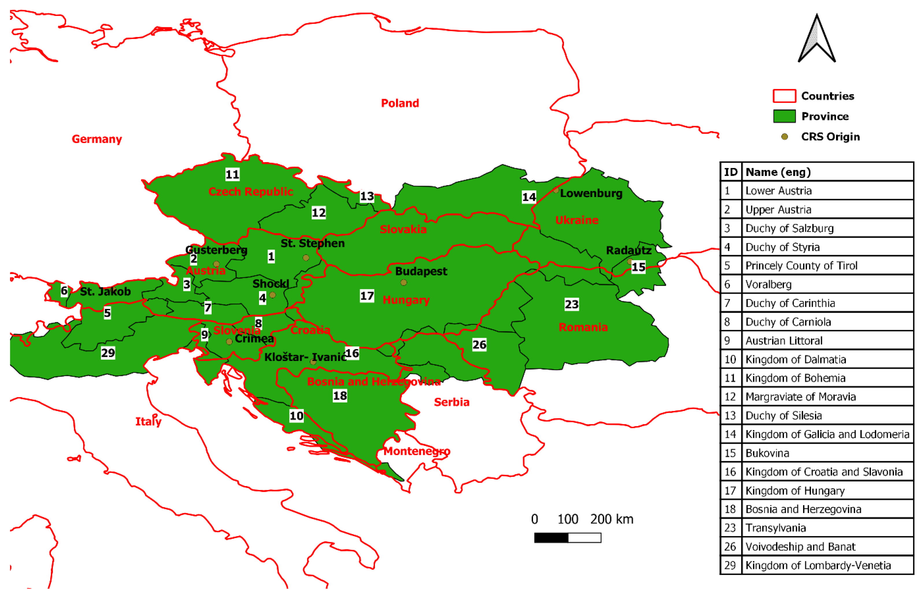
The Franciscan Cadastre, which was established in the 19th century, encompasses today’s territory of Croatia, Slovenia, Hungary, Austria, Bosnia and Herzegovina, Slovakia, Czechia and parts of the following countries: Italy, Serbia, Ukraine, Romania, Poland and Montenegro (
Figure 1).
In Austria, the digitalization of the available cadastral maps countrywide started in 1989 and was successfully completed in 2004. The data consist of different quality levels connected to different periods of data collection from the Franciscan Cadastre to the Legal Boundary Cadastre. Until 2019, 83% of the parcels still originated from Franciscan Cadastre [
35,
36]. In Croatia, the digitalization of the cadastral data started in the 1990s and was completed in 2008. Today, approximately 70% of the official cadastral data come from the period of the Franciscan Cadastre [
7,
22]. Therefore, cadastral data from the Franciscan Cadastre are important today.
2.1. Background Information
The establishment of the Franciscan Cadastre for the territory of the Monarchy began with the enactment of an imperial patent in 1817. The roots of the Franciscan Cadastre lay in the Josephian Cadastre (1785–1790), which was the first modern cadastre in the territory of the Monarchy for the purposes of the geographic research of historical landscapes. The Josephian Cadastre was not equipped with maps, but the term “cadastral municipality” with exact borders was introduced [
37].
A cadastral survey was performed in different time periods for the Austrian and Hungarian parts of the Monarchy in the Franciscan Cadastre. The cadastral survey in the Austrian part started immediately after the patent enactment and lasted until 1858, while the establishment of the cadastre in the Hungarian part started in 1847 and lasted until 1884 [
7]. Apart from the Franciscan Cadastre, there are different terms that are used by various scientists: stable, stabile, Franciscian Cadastre and others [
38].
The Monarchy was divided in the 19th century into provinces for which there were systematic works organized and performed within the cadastral survey. Because of the breakdown of the Monarchy and the historic circumstances in which it achieved independence with the formation of new countries, provinces today territorially belong to one or more country member states of the Monarchy (
Figure 1).
The land was shown in a rectangular coordinate system, as suggested by Soldner in Bavaria. To avoid deformations, the mapping areas were limited to one or more provinces, and each area was mapped to a separate coordinate system. In the Austrian part, seven rectangular coordinate systems were used, with origins in St. Stephan, Gusterberg, Krimberg, Innsbruck, Schöcklberg, Löwenburg and Radautz [
39]. In the Hungarian part, provinces were shown in coordinate systems with origins in Kloštar Ivanić and Gellérthegy [
7]. The exception was the area of Bosnia and Herzegovina, where cadastral maps were made in a polyhedral projection based on the degree division [
40].
2.2. Cadastral Documentation
The establishment of the Franciscan Cadastre was carried out by using a systematic approach in which a cadastral survey was performed for the territory of the cadastral municipality. For the purpose of the protection and storage of the documentation resulting from the cadastral survey, archives were established, and today, they are popularly called map archives [
41]. Later, archives were founded for each province in the Monarchy [
7].
The first step of the cadastral survey for the cadastral municipality was the marking and determination of its boundaries, for which a committee was established. The committee consisted of a cadastral surveyor and assistant, mayors of delimited municipalities and two representatives of each municipality to whom the course of the boundary was known.
The document that resulted from this step was called the cadastral municipality boundary demarcation record and consisted of the draft and textual description. The draft showed the cadastral municipality with boundaries, settlements, main roads and the hydrographic network. The textual description of a boundary included the exact position and description of the edge cadastral municipalities and the boundary marks on them. The record was finally signed and stamped by all the members of the commission, and if they refused, the surveyor entered the refusal into the record, which he attached in the cadastral documentation. This document was a legal document regarding the extent and boundaries of the cadastral municipality. After the survey of cadastral parcels, a record was changed or updated according to necessity. In such a case, two documents were created: the temporary and the final boundary record [
7,
42]. At this time, the borders marked on the ground were later taken as the borders of the newly formed states in most cases. More than 90% of the borders of today’s states are the borders of cadastral municipalities from the Franciscan Cadastre.
After the demarcation of the boundaries of the cadastral municipality, parcel marking by the possessors and a field survey followed. The survey was attended by a surveyor’s assistant who kept a field sketch (sometimes called an indication sketch) in which he entered data on demarcated parcels and an indication about the possessors of individual land parcels. After the field survey, during the winter period, a cadastral map was made based on a field sketch. The original cadastral maps resulting from the survey were drawn in ink and were painted. Moreover, they were signed by the cadastral surveyor and certified by the supervising surveyor.
After the preparation of cadastral maps, a list of parcels for each cadastral municipality was prepared. For the Austrian part of the Monarchy, the built and unbuilt parcels were separately numbered from 1 onwards, so they were two separate documents—a list of land parcels and a list of building parcels—while in the Hungarian part, one document was drawn up—a list of all the lands. For each parcel, the number of the parcel, the sheet of the corresponding cadastral map on which the parcel was drawn, the name and the house number of the possessor, the culture under which the parcel was located, the area of the parcel and the agricultural production capacity expressed by class were entered. The parcels were numbered using a series of numbers from 1 onwards. In addition to the list of parcels, a list of possessors was made, which contained a list of all the possessors in the cadastral municipality in the alphabetical order of their surnames.
Apart from the documents above, after the establishment of the Franciscan Cadastre, other documents, which do not form part of this study, resulted from it. There are summary tables and detailed descriptions of each village (municipality) with information about physical-geographical, social and economic situations [
43], and others.
4. Methodology and Data
The data used for this research included provinces, countries, coordinate systems, archives, catalogs, cadastral documents, services and metadata standards. The data were searched and collected on the Internet, and different methodologies were used in the research.
4.1. Methodology
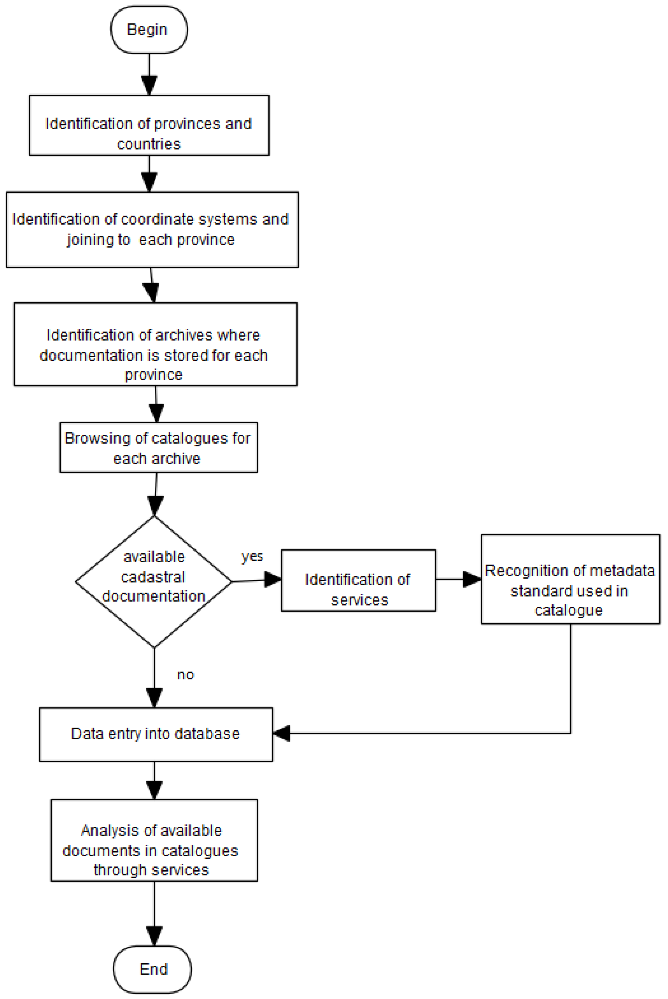
The starting point of this research included the identification of the provinces into which the Monarchy was divided in the 19th century during the establishment of the Franciscan Cadastre (
Figure 2). From the disintegration of the Monarchy until the today, new countries have been formed, so the next step included the identification of countries to which the former provinces territorially belong. The area encompassing most of today’s Central European countries was covered by the establishment of the Franciscan Cadastre in the 19th century.
The next step was to associate the rectangular coordinate system with the origin—the individual province. The provinces were mapped into rectangular coordinate systems with different origins, and most of the coordinate systems were used to map multiple provinces.
The cadastral documentation resulting from the establishment of the Franciscan Cadastre was stored in archives that were established for individual provinces. Therefore, the next step was to identify all archives in which documentation was stored and connect the archives to each province. Although one archive was initially established for each province, over time, because of the formation of new countries, new archives were established, and part of the documentation between individual archives was transferred. Therefore, today, the cadastral documentation for an individual province can be stored in several archives; the same is true for an individual country.
With the aim of increasing accessibility and use, archival cadastral documentation has been digitized and made available to users through a catalog, archive or other means. The material of a single archive can be accessed through multiple catalogs, just as a single catalog can contain material from multiple archives. Catalogs in which the documentation of all the identified archives was available were searched. The availability of documents resulting from the establishment of the Franciscan Cadastre in the catalogs was examined. The following five types of documents were defined and examined: cadastral maps, cadastral municipality boundary demarcation records (description), lists of land parcels, lists of building parcels and lists of possessors. In some catalogs, all the cadastral documentation was united, so the term general cadastral documentation (general) was introduced. If the documents were available within the catalog, the identification of services that could be accessed for each document followed. Services were identified in accordance with the INSPIRE service types. According to INSPIRE, the following types of services were defined: discovery, view, download, transformation, invoke and others [
50]. In the case of cadastral documentation, three services were used: discovery, view and download. The discovery service allowed us to find a document that was described by the metadata according to a certain standard. The view service allowed us to view an individual document, while the download service provided the ability to download a document in a certain format.
The documentation in the catalogs, which was available through the discovery service, was described by the metadata standards. We examined the applicability of geographic information metadata standards and metadata standards for archival documentation in catalogs in which cadastral documentation was found.
After all the catalogs were browsed, the collected data were entered into a database. The database was used for further analyses of the availability of cadastral documents conducted as part of the research. All the data entered in the database are described in detail in the following section.
4.2. Data
In total, 21 provinces were identified. The provinces that belonged to the Austrian part of the Monarchy were Lower Austria, Upper Austria, Duchy of Salzburg, Duchy of Styria, Princely County of Tirol, Vorarlberg, Duchy of Carinthia, Duchy of Carniola, Austrian Littoral, Kingdom of Dalmatia, Kingdom of Bohemia, Margraviate of Moravia, Duchy of Silesia, Kingdom of Galicia and Lodomeria, Bukovina and Kingdom of Lombardy-Venetia [
39]. The provinces that belonged to the Hungarian part were Kingdom of Croatia and Slavonia, Kingdom of Hungary, Bosnia and Herzegovina, Transylvania, Voivodeship and Banat. Each province was associated with a coordinate system in which the province was mapped. In all, nine rectangular coordinate systems and a polyhedral projection were used for the province of Bosnia and Herzegovina.
The data of the countries that territorially covered the area of the former provinces were also collected and analyzed. In all, there were 13 countries. The attributes of these countries were as follows: the name of the country and the numeric and alpha-2 codes in accordance with the ISO 3166 [
51] standard. The provinces were connected to the countries, and the relationship between the provinces and the countries was many-to-many.
Archives in which the documentation was stored were connected to the provinces. For each archive, the name of the archive in the native language, the city in which the archive was located and the network address of the archive institution were collected. In total, 29 archives were identified. The documentation stored in the archives was made available to users through the catalogs. Attributes assigned to the catalogs were the name of the catalog and a network address through which the documentation could be searched. In all, 17 catalogs were found, of which 15 were archival and 2—namely Open Data Austria [
52] and Mapire [
53,
54]—were not archival. Open Data Austria offers a catalog of open datasets and services from the public administration based on the open data principles. Mapire is a portal that presents historical maps of several countries. It also contains cadastral maps of the Franciscan Cadastre from the 19th century and enables users to view most of the cadastral maps for the area of the Austrian-Hungarian Monarchy. Mapire was created by a private company in cooperation with several institutions, most of which were state archives.
In total, six types of documents were defined and searched in the catalogs. The available types of documents were collected for each catalog, as well as the service which enabled the accessibility: discovery, view or download. Documents in catalogs that were available through the discovery service were described by metadata standards. In this case, the catalog was accompanied by a metadata standard that described its documents. In all, four different metadata standards were identified to which the following attributes were associated: signature, name, body which developed the standard and year of edition used. Metadata standards identified in the catalogs were as follows: Dublin Core, OGD Metadaten 2.4 [
55], ISAD(G) and SIAS [
56] standards.
5. Analysis and Results
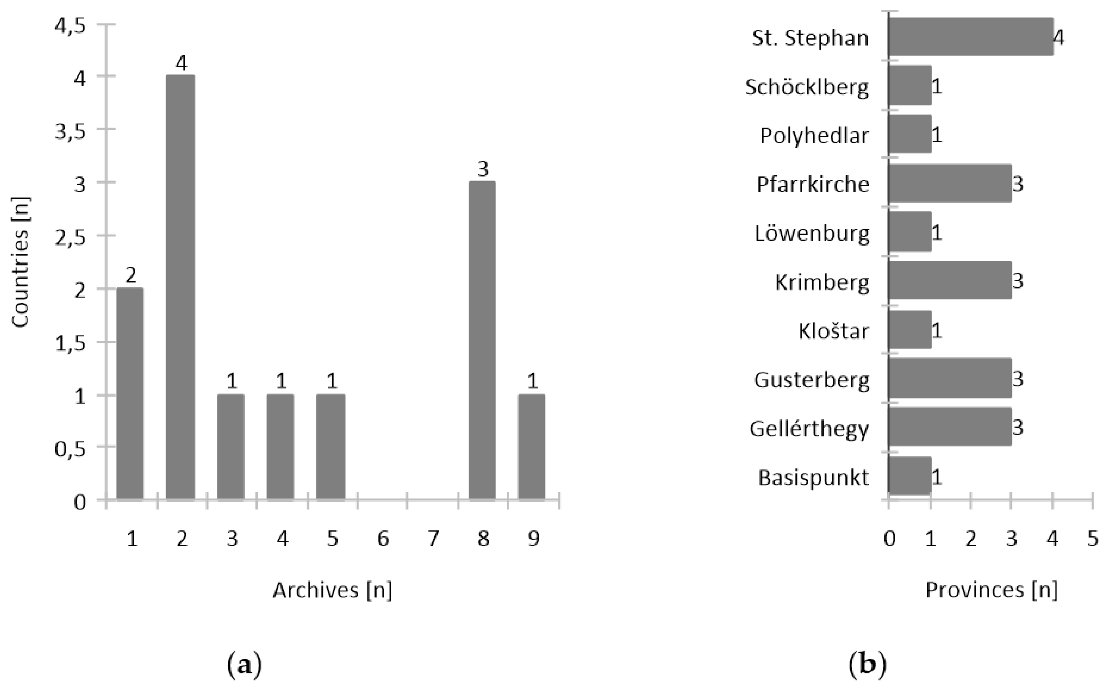
Statistical analyses were performed on the collected, structured and interpreted data. The relationship between countries and archives was analyzed first. In
Figure 3a, the total number of countries is shown in relation to the total number of archives in which cadastral documentation is stored today. The purpose of
Figure 3a is to show the dispersion of the documentation of each country in multiple archives. For most countries—a total of 11—the cadastral documentation is stored in more than one archive. The documentation for the largest number of countries—a total of four—is stored in two different archives. Initially, one archive was established for each province. Because of the formation of new countries, new archives were established, and part of the documentation was transferred between archives. Therefore, today, cadastral documentation for an individual country of the Franciscan Cadastre is stored in several archives. Only two countries have documentation stored in one archive.
The following analysis focused on the relationship between the provinces and the coordinate system (origin) used to map the area of a province (
Figure 3b). Some coordinate systems were used to map multiple provinces. The graph shows the total number of provinces according to the origin of the coordinate system. Coordinate systems with the origin St. Stephan were used to map the largest number of provinces—a total of four. Pfarrkirche, Krimberg, Gusterberg and Gellérthegy were used to map three provinces, and the remaining five systems were used to map one province.
5.1. Availability of Cadastral Documents of the Franciscan Cadastre in Catalogs
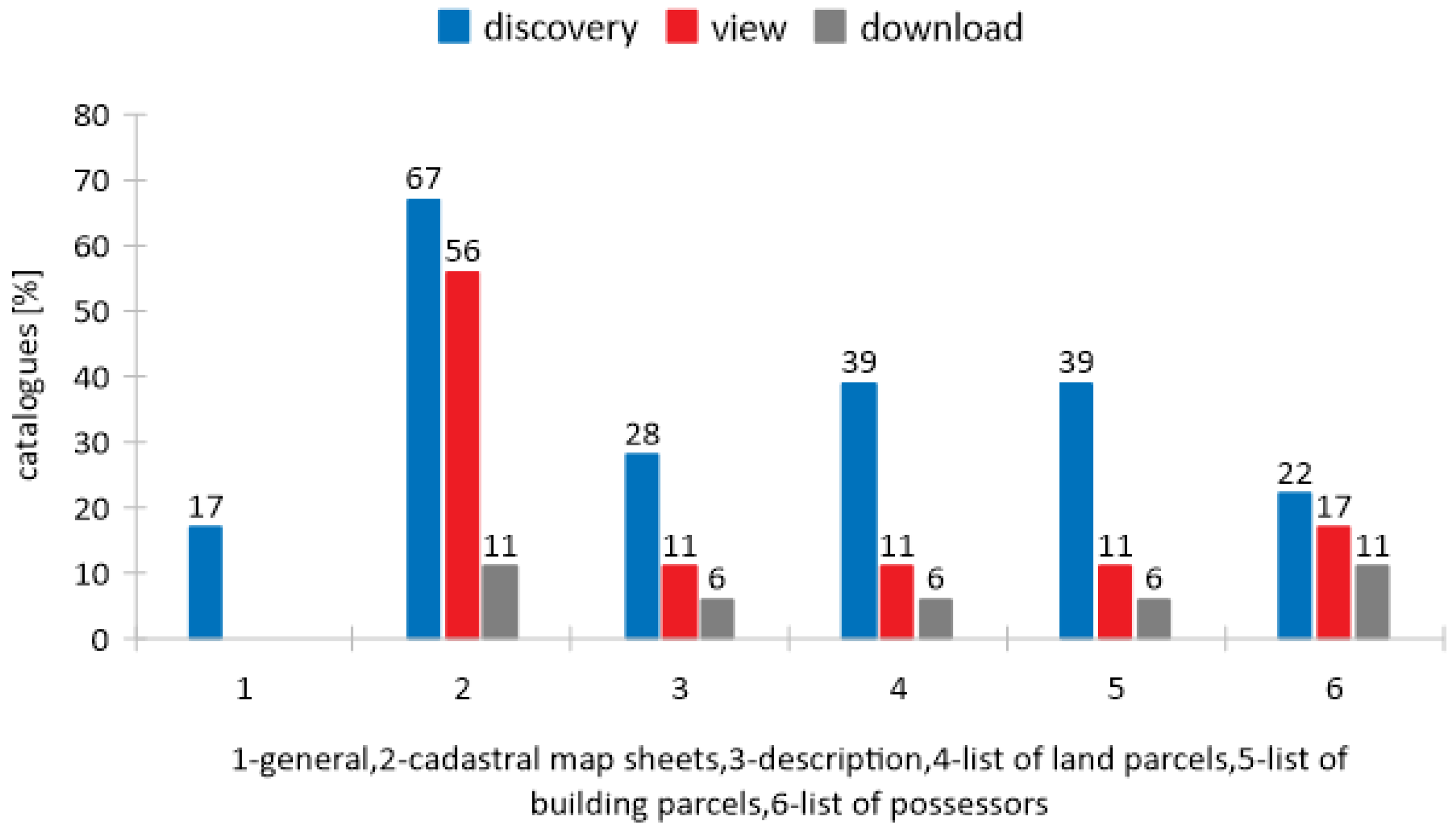
The availability of cadastral documentation was examined through the identified catalogs. Access to the documents in the researched catalogs was possible through the discovery, view and download services, depending on the type of document and the individual catalog. For each of the three services, the percentage of catalogs was analyzed according to the availability of each type of document (
Figure 4). The percentage of the total number of catalogs found according to the available type of document through the three services is shown in
Figure 4. In all, 17 catalogs were found, of which 16 had access to at least one type of document through one of the services. Only the catalog HISTORICALkat [
57] was not public, and registration was required.
The largest percentage of catalogs had access to documents through the discovery service, and the lowest percentage had access through the download service. Most of the documents available through the discovery service were cadastral map sheets, at 67% of the total number of catalogs. The least available document in the catalogs was general cadastral documentation, at 19%. The availability of documents through the view service was lower, and the most available documents were cadastral map sheets, at approximately 56%. The lowest availability of documents in the catalogs was through the download service, at approximately 6% for descriptions, lists of land parcels and lists of building parcels. Cadastral map sheets and lists of possessors were the types of documents that were the most available through the download service, comprising approximately 11% of the total number of catalogs.
As the documents were the most available materials in the catalogs through the discovery service, the next step was the analysis of the availability of documents for each province through the discovery service. The results are shown in
Table 1, and there are 19 out of 21 provinces in total for which at least one type of document was found. The column Catalog(s) contains references to the catalogs found for each province where documents were available. For the two provinces of Bosnia and Herzegovina and Voivodeship and Banat, no documentation was found. Documents of some provinces are available in several catalogs, while the others are available in the one catalog.
The most common documents in all the provinces were cadastral map sheets, and they were available for 18 provinces through the discovery service. General cadastral documentation was available for the smallest number of provinces—a total of four.
In total, nine provinces had all types of documents resulting from the establishment of the Franciscan Cadastre: cadastral map sheets, descriptions, lists of building and land parcels and lists of possessors. Four provinces had general cadastral documentation, where all the documents were described together by the metadata elements. The documentation of Duchy of Carinthia was specific because the corresponding documents were available from three catalogs. In one of the catalogs, each of the documents for Duchy of Carinthia was described by metadata elements, while in the other catalogs, general cadastral documentation was described.
5.2. Application of Metadata Standards to Catalogs
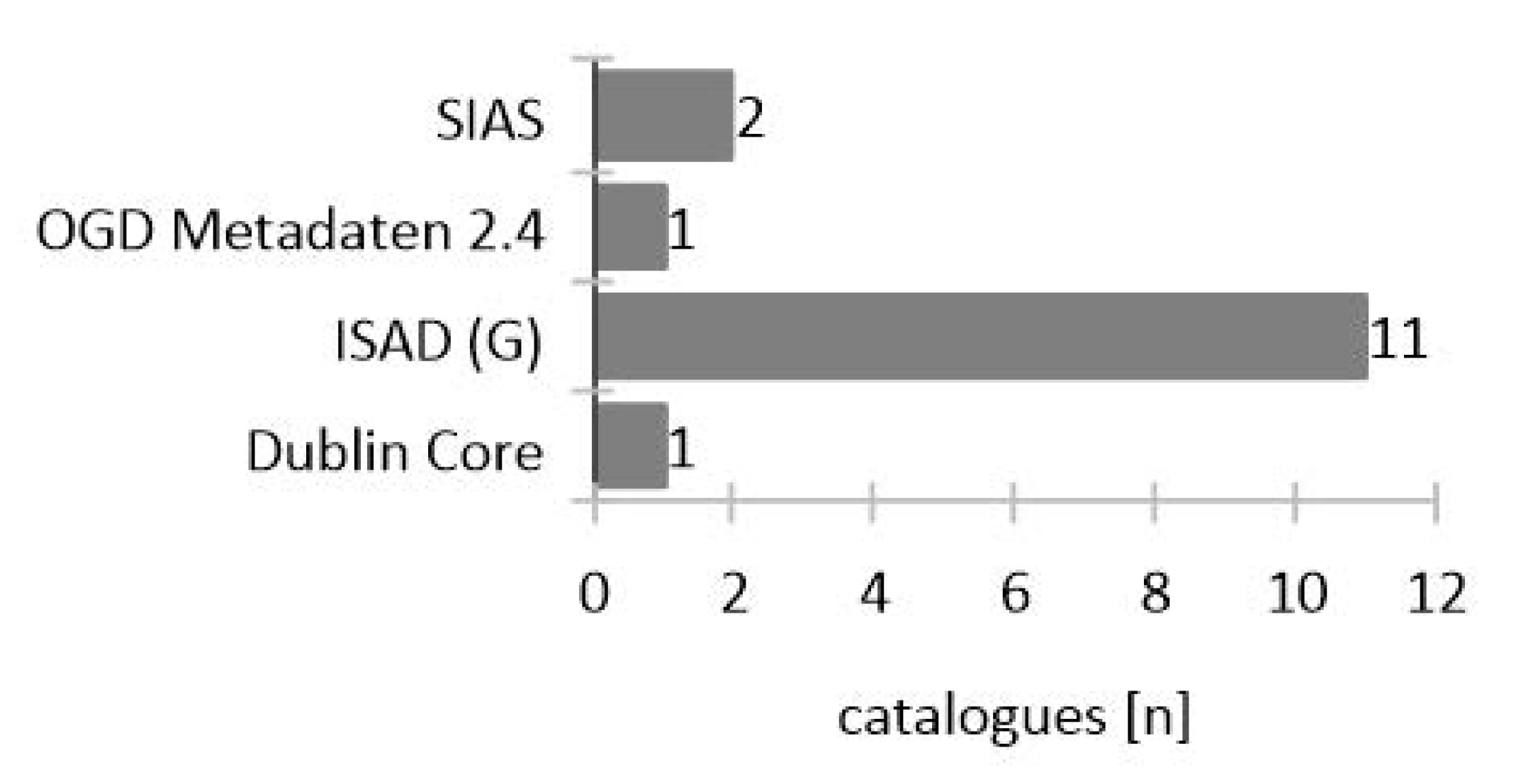
When documents were available in the catalogs through the discovery service, they were described by the metadata elements in accordance with some of the metadata standards. The study showed that ISAD(G), Dublin Core, OGD Metadaten 2.4 and SIAS were the metadata standards used to describe the cadastral documentation of the Franciscan Cadastre. The total number of catalogs in relation to the used metadata standard is shown in
Figure 5.
The most widely used standard for describing cadastral documentation was ISAD(G) (International Standard for Archival Description). ISAD(G) was used in 11 catalogs, as most of the catalogs in this study were of the archival type. After ISAD(G), SIAS was used in two catalogs; both were catalogs from Italy. Dublin Core was used in the catalog of Hungaricana, and OGD Metadaten 2.4 was used in the catalog of Open Data Austria.
An example of a catalog in which metadata standards were used is given in the following sections. The catalog of Archive of Republic of Slovenia (ARS) was chosen as an example of using ISAD(G), and the catalog of Archive of Trieste was chosen as an example of using the SIAS standard. Hungaricana was the only catalog in which Dublin Core was used. The available documents and hierarchical structure are given for all the examples of catalogs. All these catalogs had cadastral map sheets available through the discovery service. Therefore, the sheets were chosen as an example of cadastral documents to show which metadata elements of each metadata standard were used to describe the cadastral documentation. The elements of the used metadata standards were semantic mapping with the elements of ISO 19115-1: 2014 [
47]. The catalog of Open Data Austria was not included in the semantic mapping because documentation was described as general for each province and no document was described individually.
5.2.1. ISAD(G)—Archive of Republic of Slovenia (ARS)
The archive catalog of ARS is an example of catalog in which the ISAD(G) standard is used [
59]. Archive catalogs have a hierarchical structure, which implies that information is arranged in levels and descriptions proceed from the general to the specific. Some examples of levels are fonds, sub-fonds, series, sub-series, file and item. The fonds level is the highest level, and the item is the lowest level. Fonds may be described as a whole in a single description or represented as a whole and its parts with various levels of description. Thus, there may be a fonds-level description, a series-level description, a file-level description and/or an item-level description. Intermediate levels, such as sub-fonds or sub-series, may be excepted [
33].
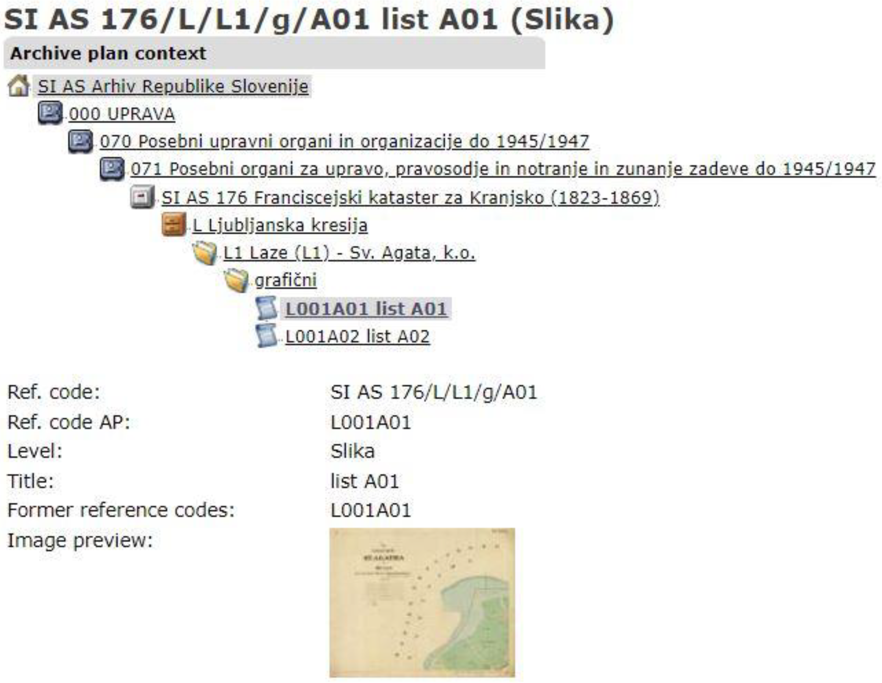
The catalog of the ARS contains the archival documentation of the Franciscan Cadastre for four provinces: Duchy of Carinthia, Duchy of Carniola, Duchy of Styria and Austrian Littoral. The hierarchical structure of the stored and description documents is in accordance with ISAD(G), and there are the following levels: fonds, sub-fonds, files and items. Series do not exist for cadastral documents. In
Figure 6, the hierarchical structure is shown for the province of Duchy of Carniola and a part of the metadata elements used to describe a cadastral map sheet as an item.
The higher-level fonds are provinces, which are described with the largest number of metadata elements. After fonds followed sub-fonds, which contained files regarding cadastral municipalities. Each cadastral municipality contained graphics (files) and listed parts (files). The graphic part contained cadastral map sheets (items), and the listed part contained the following items: descriptions, lists of land parcels, lists of building parcels and lists of possessors. Each of the levels (fond, sub-fond, file and item) was described by the metadata elements and was available through the view service. The documents were also available through the download service, except for the cadastral map sheets.
Semantic mapping between two metadata standards, namely ISAD(G) and ISO 19115-1: 2014, was performed (
Table 2).
All the metadata elements used to describe provinces were analyzed. At the highest appropriate level (provinces), elements common to the component parts were given, and they did not repeat at a lower level of description. All the ISAD(G) elements that are used to describe the documents of the Franciscan Cadastre in the catalog of ARS are given in
Table 2. Some of the elements have a different name in the catalog than in the ISAD(G) standard, so both of ISAD(G) and ARS and elements are given. The element URL was additional in the catalog.
5.2.2. Catalog of the Archive of Trieste—SIAS Standard
The catalog of the State Archive of Trieste [
58] contains a set of cadastral and cartographic sources, of different natures and origins, that have been digitally acquired since the 2000s. The data are managed by the Divenire software and in parallel by the software for the communication of archival descriptions AriannaWeb. The documentation of the Franciscan Cadastre for the province of Austrian Littoral is stored in the catalog of Trieste. All the documents defined in this study were available in the catalog through the discovery and view services: cadastral map sheets, lists of land parcels, lists of building parcels, lists of possessors and descriptions.
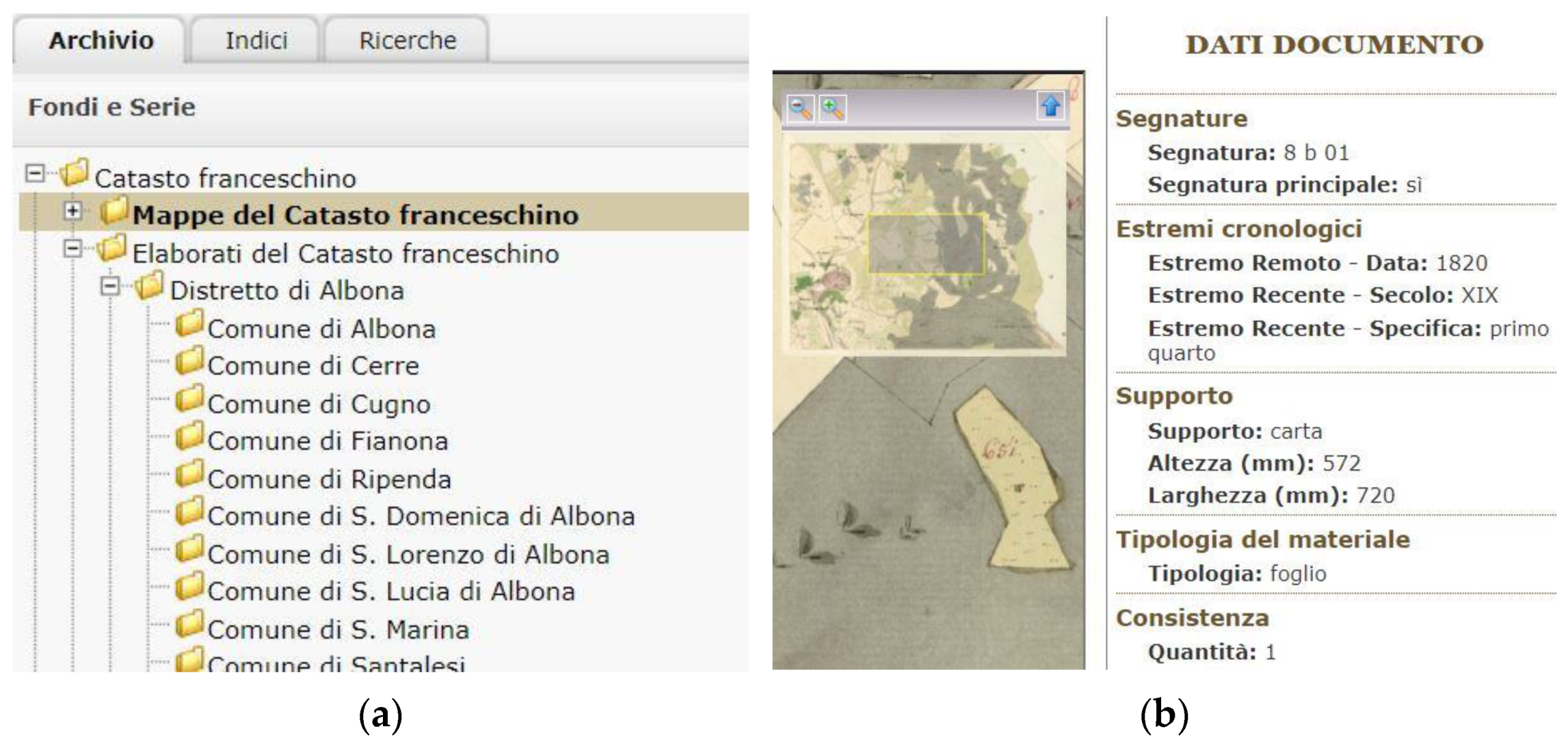
The hierarchical structure of the catalog is different than that in ARS. The documentation of the Franciscan Cadastre is divided into two parts: mappe and elaborati. Each of these is further divided by districts, containing cadastral municipalities (
Figure 7a). Each folder of a cadastral municipality contains documents: in mappe, the cadastral map sheets are included, and the other documents defined in this study are in elaborati.
Each part pf the hierarchical structure of the catalog is described by the metadata elements, as well as each document (
Figure 7b). The cadastral map sheet had the largest number of elements, so it was used as an example whose elements were semantically mapped with the elements of ISO 19115-1: 2014 (
Table 3).
In the first column of
Table 3, SIAS elements are used to describe one cadastral map sheet, and in the other column, there are semantically mapped elements of ISO 19115. Most of the elements in the catalog of Archive of Trieste have a corresponding element in the ISO 19115 standard. Each cadastral map sheet in a cadastral municipality is a unit described with the metadata elements. The same is true for all the other documents in
mappe: descriptions, lists of land parcels, lists of building parcels and lists of possessors.
5.2.3. Hungaricana—Dublin Core
Hungaricana [
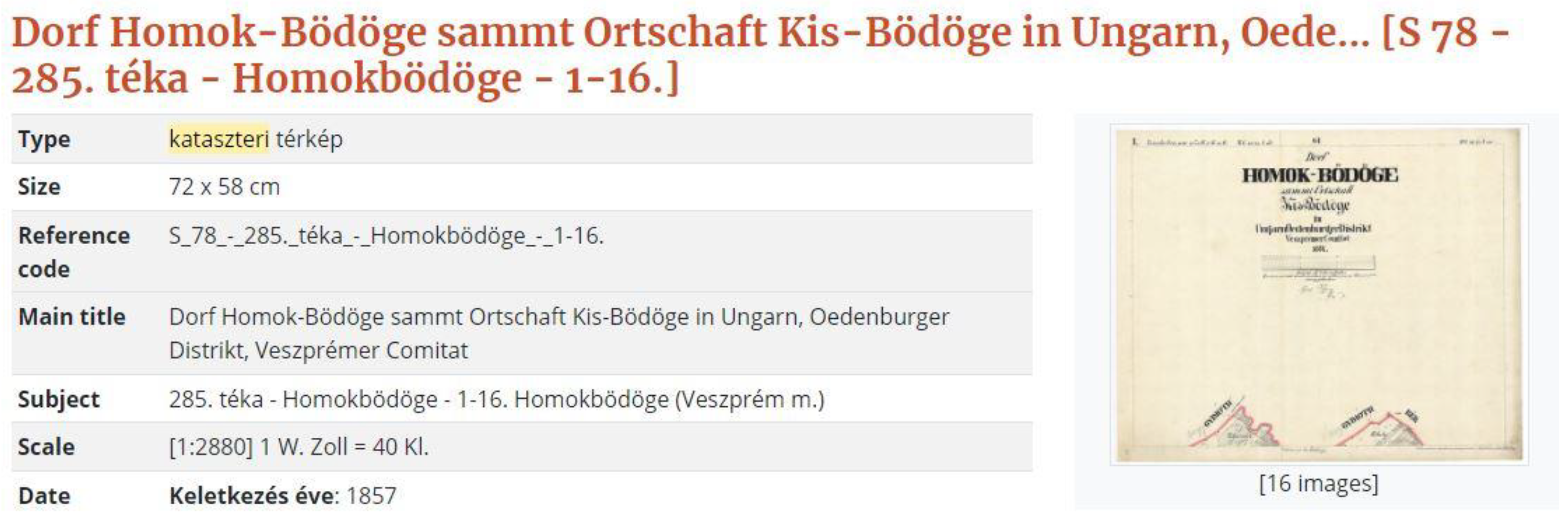
66] is a catalog that contains the cadastral map sheets of the Franciscan Cadastre for the province of Kingdom of Hungary. Hungaricana is a common website of Hungarian archives, museums and libraries, and its main goal is to publish the cultural heritage of Hungary on one site: databases, records, documents, images, maps, etc. Now, more than 100 institutes serve data, and some of them are in foreign countries. The main databases are Library, Postcards, MAPIRE, Maps, Documents and Old Hungarian Library. The cadastral map sheets are in the databases Maps and MAPIRE. In MAPIRE, the cadastral map sheets are available only through the view service, while in Documents, the cadastral map sheets are described by metadata elements in accordance with the Dublin Core metadata standard (
Figure 8).
In
Figure 8, one part of the metadata elements used to describe cadastral map sheets for a cadastral municipality is shown. The difference in the relationship to ARS and the catalog of Trieste is that in Hungaricana, all the cadastral map sheets for one cadastral municipality are described together, not individually, by the Dublin Core elements. The semantic mapping between the Dublin Core and the ISO 19115-1: 2014 elements is shown in
Table 4.
The names of some of the elements in Hungaricana are different from those of the elements in the Dublin Core standard; therefore, both names are given in
Table 4. From all of the 15 core metadata elements, nine are used to describe cadastral map sheets in Hungaricana. Scale is the only additional element. Most of the elements have a corresponding element in ISO 19115.
6. Discussion
This study was focused on the availability of cadastral documentation resulting from the establishment of the Franciscan Cadastre, which is the foundation of today’s official cadastral data in most Central European countries. A systematic approach to the establishment of the Franciscan Cadastre resulted in the following documents: cadastral maps, cadastral municipality boundary demarcation records (descriptions), lists of land parcels, lists of building parcels and lists of possessors. These five documents were defined as the key cadastral survey products of one cadastral municipality for the purpose of the establishment of a cadastre. Other cadastral documents, which were stored in the archives, resulted from the maintenance of cadastral data.
The documentation of the Franciscan Cadastre is stored in various archives established for the individual provinces into which the Monarchy was divided in the 19th century. Today, the provinces territorially belong to one or more countries, which has led to the dispersion of documentation in several archives (
Figure 3a). Through the catalogs, most of which are archival, the documentation has become available to users. The availability of documentation was examined through three services: discovery, view and download. The largest percentage of documents was available through the discovery service. The analysis indicated a different percentage of documentation availability in the catalogs. Cadastral map sheets were available through all the three services in the highest percentage of the catalogs (
Figure 4). The documents available by the discovery service were described by metadata standards. Catalogs through which documentation was available to users differed in their hierarchical structure and the metadata standards used for their description. Thus, the documentation for one cadastral municipality could be found in several catalogs, while each catalog was structured differently and described with a different metadata standard. For most of the provinces, each of the documents was described separately, while in some cases, the documentation obtained from the establishment of a cadastre was consolidated (general) and as such described by the standard (
Table 1).
As most of the catalogs were of the archival type, the most used metadata standard was ISAD(G), the international standard for describing archival documentation. From a total of 15 identified catalogs, 11 catalogs used the ISAD(G) standard to describe the Franciscan Cadastre documentation. As cadastral data are one of the basic spatial datasets, the research pointed to the lack of application of geoinformation metadata standards, except for Dublin Core, which is a general metadata standard. The international standard ISO 19115-1: 2014 could be applied for the description of cadastral documents, both for cadastral maps and for other textual documents resulting from the establishment of a cadastre. The semantic mapping of the elements of the standards used in the catalogs with the elements of the standard ISO 19115-1: 2014 presented the high percentage of semantic similarity (
Table 5). The elements used to describe a cadastral map sheet, which mainly contained all the elements used to describe the remaining documents, were analyzed.
In Hungaricana, the cadastral map sheets of one cadastral municipality are described together, while in ARS and Trieste, each cadastral map sheet is described separately. The ISAD(G) standard, used in the ARS, describes the fond (province) as the highest level, and for the lower levels, elements that are identical to elements at a higher level are not repeated. Therefore, the elements of an individual province that are valid for the lower level (item), corresponding to the lists of cadastral maps, were analyzed for the ARS. The highest percentage of compliance with ISO 19115 was exhibited by the Dublin Core standard, with a total of 100% elements. ISAD(G), as the most used standard for describing cadastral documents, showed a 95% correspondence with the ISO 19115 standard and the SIAS standard. This study did not include all the elements of the identified standards but only those used for documents resulting from the establishment of the Franciscan Cadastre. The number of elements used for description also differed in the catalogs, and the largest number was used in the catalog of archives in Trieste, with a total of 21 elements.
7. Conclusions
A systematic approach to the establishment of the Franciscan Cadastre in most Central European countries resulted in cadastral documents stored in national archives. Among the multitude of documents stored in the archives, five main documents were identified as the results of the establishment of the cadastre: cadastral map sheets, cadastral municipality boundary demarcation records (description)s, lists of land parcels, lists of building parcels and lists of possessors. Other cadastral documents in archives were the results of the maintenance of cadastral data. The dispersion of documents for each country in more archives was the result of the formation of new countries, where each country took over the documentation for their territorial area.
Documents stored in the archives were available through different catalogs; for the majority of the archives, access was enabled for users through the discovery, view and download services. The largest number of identified catalogs allowed access to documents through the discovery service, and the smallest number allowed access through the download service. The type of document represented in the largest percentage of the identified catalogs was the cadastral map sheets. In total, 67% of the catalogs allowed access to the cadastral map sheets through the discovery service, 56% through the view service, and 11% allowed access through the download service. In 17% of the identified catalogs, the Franciscan Cadastre documentation was consolidated and available through the discovery service. The documents available through the discovery service were described by the elements of the applied metadata standard. The largest number of catalogs, 11 out of 15, used ISAD(G)—the international standard for the description of archival documentation—because most of the identified catalogs were of the archival type. In addition to ISAD(G), the metadata standards used in the catalogs were Dublin Core, SIAS standard and OGD Metadaten 2.4.
In this study, we determined a lack of application of geoinformation metadata standards regarding cadastral data, which represented fundamental spatial datasets. One of the geoinformation metadata standards whose applicability was tested in this study was the international standard ISO 19115-1: 2014. The semantic mapping of the elements of the applied standards in the catalogs and the elements of ISO 19115-1: 2014 showed a considerable congruence of elements, at more than 95%. Therefore, the following conclusion was reached: it is possible to apply the ISO 19115-1: 2014 standard to documents resulting from the establishment of the Franciscan Cadastre. In addition to the analyzed documents, further research can include documents from maintenance and renewal due to the resurveying of cadastral data.