
The Spatial Effect of Administrative Division on Land-Use Intensity


Abstract
:1. Introduction
2. Theoretical Framework
3. Materials and Methods
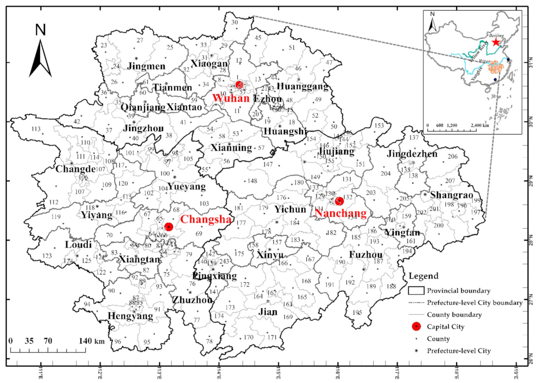
3.1. Study Area
3.2. Methods
3.2.1. Measurement on LUI and the Selection of Driving Factors
3.2.2. Model Specification
Spatial Regression Model
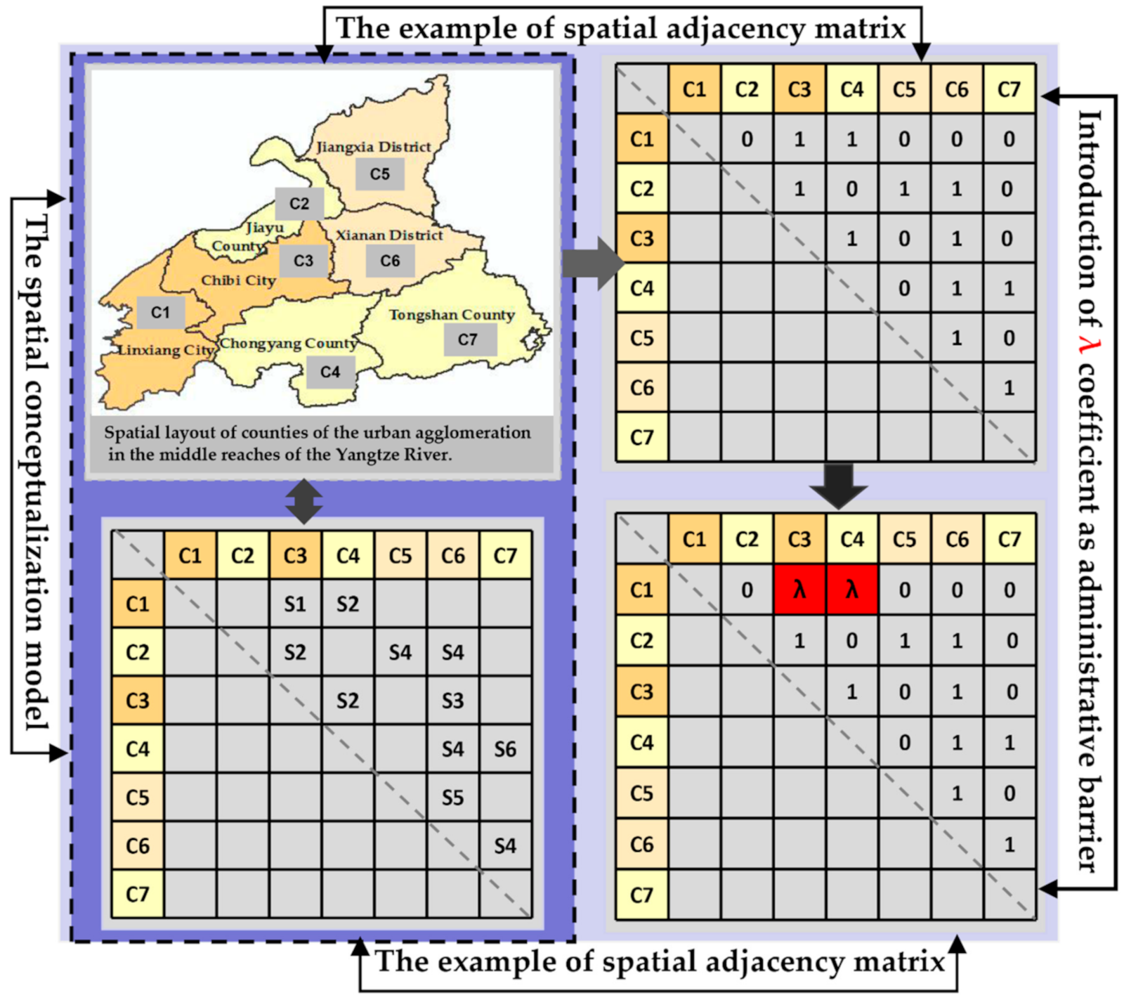
Administrative Embedded Spatial Econometric Model
4. Results
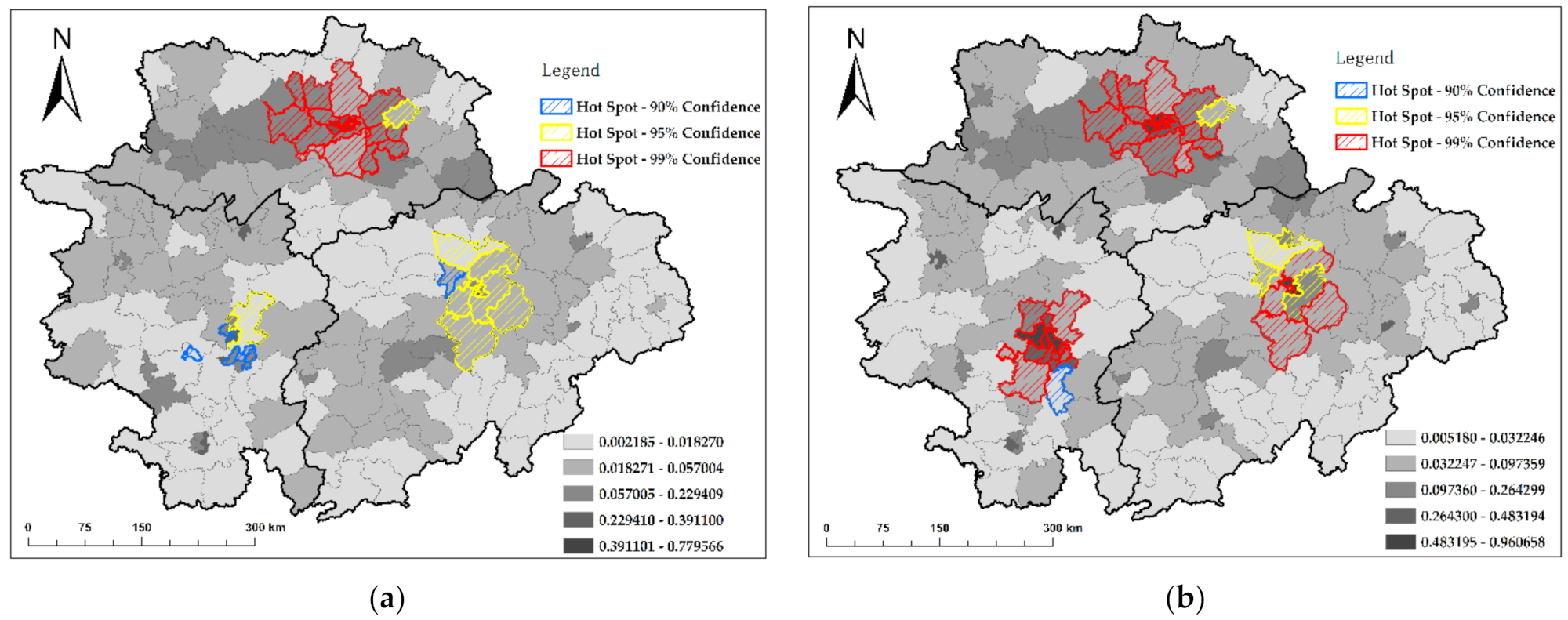
4.1. Spatio-Temporal Variability of LUI
4.2. Driving Forces of LUI
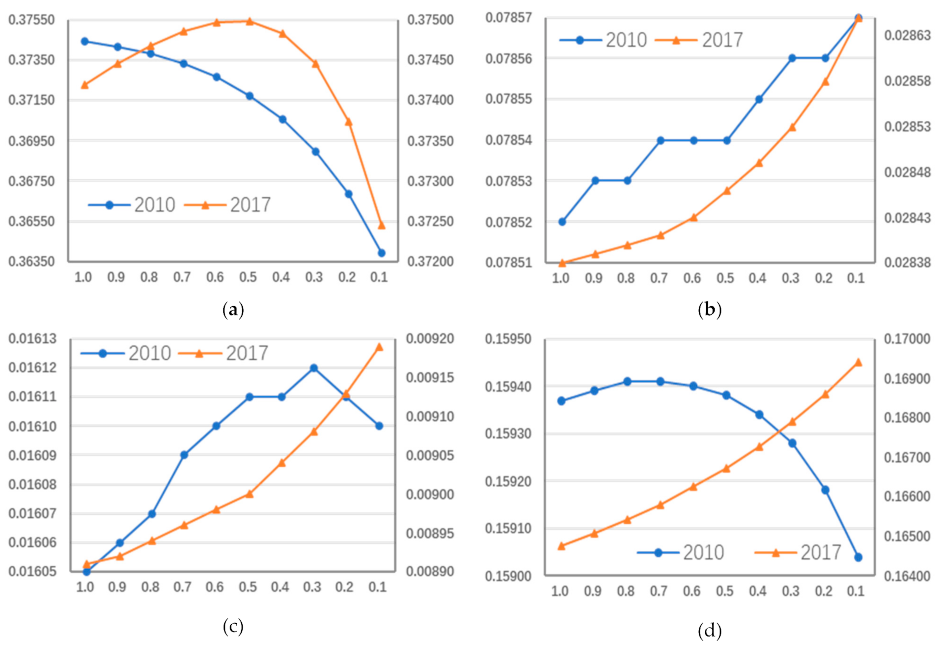
4.3. Administrative Barriers
5. Discussion
6. Conclusions
Author Contributions
Funding
Institutional Review Board Statement
Informed Consent Statement
Data Availability Statement
Acknowledgments
Conflicts of Interest
References
- Zhang, P.Y.; Yang, D.; Qin, M.Z.; Jing, W.L. Spatial heterogeneity analysis and driving forces exploring of built-up land development intensity in Chinese prefecture-level cities and implications for future Urban Land intensive use. Land Use Policy 2020, 99, 104958. [Google Scholar] [CrossRef]
- Melnychuk, A.; Gnatiuk, O. Regional identity and the renewal of spatial administrative structures: The case of Podolia, Ukraine. Morav. Geogr. Rep. 2018, 26, 42–54. [Google Scholar] [CrossRef] [Green Version]
- Colsaet, A.; Laurans, Y.; Levrel, H. What drives land take and urban land expansion? A systematic review. Land Use Policy 2018, 79, 339–349. [Google Scholar] [CrossRef]
- Quintas-Soriano, C.; Castro, A.J.; Castro, H. Impacts of land use change on ecosystem services and implications for human well-being in Spanish drylands. Land Use Policy 2016, 54, 534–548. [Google Scholar] [CrossRef]
- Cegielska, K.; Noszczyk, T.; Kukulska, A.; Szylar, M.; Hernik, J.; Dixon-Gough, R.; Jombach, T.; Valánszki, I.; Kovács, K.F. Land use and land cover changes in post-socialist countries: Some observations from Hungary and Poland. Land Use Policy 2018, 78, 1–8. [Google Scholar] [CrossRef]
- Kong, X.S.; Jiang, X.J.; Liu, Y.; Jin, Z.F. Spatiotemporal Coupling Between Territorial Space Development Intensity and Resource Environmental Carrying Capacity and Its Planning Implications: A Case Study of Jiangsu Province. China Land Sci. 2020, 34, 10–17. [Google Scholar]
- Wellmann, T.; Haase, D.; Knapp, S.; Salbach, C.; Selsam, P.; Lausch, A. Urban land use intensity assessment: The potential of spatiotemporal spectral traits with remote sensing. Ecol. Indic. 2018, 85, 190–203. [Google Scholar] [CrossRef]
- Huang, X.; Huang, X.J.; Liu, M.M.; Wang, B.; Zhao, Y.H. Spatial-temporal Dynamics and Driving Forces of Land Development Intensity in the Western China from 2000 to 2015. Chin. Geogr. Sci. 2020, 30, 16–29. [Google Scholar] [CrossRef] [Green Version]
- Salvati, L.; Carlucci, M. Patterns of sprawl: The socioeconomic and territorial profile of dispersed urban areas in Italy. Reg. Stud. 2016, 50, 1346–1359. [Google Scholar] [CrossRef]
- Song, X.P.; Hansen, M.C.; Stehman, S.V.; Potapov, P.V.; Tyukavina, A.; Vermote, E.F.; Townshend, J.R. Global land change from 1982 to 2016. Nature 2018, 560, 639–643. [Google Scholar] [CrossRef]
- Salvati, L.; Zambon, I.; Chelli, F.M.; Serra, P. Do spatial patterns of urbanization and land consumption reflect different socioeconomic contexts in Europe? Sci. Total Environ. 2018, 625, 722–730. [Google Scholar] [CrossRef]
- Shu, C.; Xie, H.L.; Jiang, J.F.; Chen, Q.R. Is Urban Land Development Driven by Economic Development or Fiscal Revenue Stimuli in China? Land Use Policy 2018, 77, 107–115. [Google Scholar] [CrossRef]
- Wang, Z.W.; Lu, C.H. Urban land expansion and its driving factors of mountain cities in China during 1990–2015. J. Geogr. Sci. 2018, 28, 1152–1166. [Google Scholar] [CrossRef] [Green Version]
- Zeng, C.; Song, Y.; Cai, D.W.; Hu, P.Y.; Cui, H.T.; Yang, J.; Zhang, H.X. Exploration on the spatial spillover effect of infrastructure network on urbanization: A case study in Wuhan urban agglomeration. Sustain. Cities Soc. 2019, 47, 101476. [Google Scholar] [CrossRef]
- Li, C.; Zhao, J.; Xu, Y. Examining spatiotemporally varying effects of urban expansion and the underlying driving factors. Sustain. Cities Soc. 2017, 28, 307–320. [Google Scholar] [CrossRef]
- Huang, H.; Wei, Y.D. Spatial inequality of foreign direct investment in China: Institutional change, agglomeration economies, and market access. Appl. Geogr. 2016, 69, 99–111. [Google Scholar] [CrossRef]
- Wang, K.Y.; Wang, F.Y. Theory and measurement model of administrative region potential from a perspective of administrative division adjustment: Taking Chongqing city as a case study. J. Geogr. Sci. 2020, 30, 1341–1362. [Google Scholar] [CrossRef]
- Yu, H.; Deng, Y.; Xu, S. Evolutionary pattern and effect of administrative division adjustment during urbanization of China: Empirical analysis on multiple scales. Chin. Geogr. Sci. 2018, 28, 758–772. [Google Scholar] [CrossRef] [Green Version]
- Feng, R.D.; Wang, K.Y. Spatiotemporal effects of administrative division adjustment on urban expansion in China. Land Use Policy 2021, 101, 105143. [Google Scholar] [CrossRef]
- Zeng, C.; Zhang, A.L.; Xu, S. Urbanization and administrative restructuring: A case study on the wuhan urban agglomeration. Habitat Int. 2016, 55, 46–57. [Google Scholar] [CrossRef]
- Hong, K.R.; Zou, Y.C.; Zhu, M.Y.; Zhang, Y.W. A Game Analysis of Farmland Expropriation Conflict in China under Multi-Dimensional Preference: Cooperation or Resistance? Land 2021, 10, 124. [Google Scholar] [CrossRef]
- Zeng, C.; Zhang, A.L.; Liu, L.; Liu, Y. Administrative restructuring and land-use intensity-A spatial explicit perspective. Land Use Policy 2017, 67, 190–199. [Google Scholar] [CrossRef]
- Li, Y.R.; Li, Y.; Karácsonyi, D.; Liu, Z.J.; Wang, Y.S.; Wang, J.Y. Spatio-temporal pattern and driving forces of construction land change in a poverty-stricken county of China and implications for poverty-alleviation-oriented land use policies. Land Use Policy 2020, 91, 104267. [Google Scholar] [CrossRef]
- Sheng, M.J.; Gu, C.L. Economic growth and development in Macau (1999–2016): The role of the booming gaming industry. Cities 2018, 75, 72–80. [Google Scholar] [CrossRef]
- Sedakov, A.A.; Sorokin, V.A. Solutions of Cooperative Games with a Major Player and a Hierarchical Structure. Autom. Remote Control. 2021, 82, 160–171. [Google Scholar] [CrossRef]
- Hilbe, C.; Šimsa, Š.; Chatterjee, K.; Nowak, M.A. Evolution of cooperation in stochastic games. Nature 2018, 559, 246–249. [Google Scholar] [CrossRef]
- Zheng, Y.T.; Zhao, S.; Huang, J.Y.; Lv, A.F. Analysis of the Spatiotemporal Pattern and Mechanism of Land Use Mixture: Evidence from China’s County Data. Land 2021, 10, 370. [Google Scholar] [CrossRef]
- Zhang, M.Y.; Chen, Q.X.; Zhang, K.W.; Yang, D.Y. Will Rural Collective-Owned Commercial Construction Land Marketization Impact Local Governments’ Interest Distribution? Evidence from Mainland China. Land 2021, 10, 209. [Google Scholar] [CrossRef]
- Ma, Y.G.; Chiu, R.L.H. Governing rural redevelopment and re-distributing land rights: The case of Tianjin. Land Use Policy 2018, 72, 533–546. [Google Scholar] [CrossRef]
- Wang, X.Z.; Qian, H.; Liu, Z.Y. The Positioning of the County-level Territorial Master Plan from the Perspective of Spatial Governance. Urban Plan. Forum 2020, 03, 65–72. [Google Scholar]
- Ma, L.B.; Chen, M.M.; Fang, F.; Che, X.L. Research on the spatiotemporal variation of rural-urban transformation and its driving mechanisms in underdeveloped regions: Gansu Province in western China as an example. Sustain. Cities Soc. 2019, 50, 101675. [Google Scholar] [CrossRef]
- Wang, J.J.; Yeh, A.G.O. Administrative restructuring and urban development in China: Effects of urban administrative level upgrading. Urban Stud. 2020, 57, 1201–1223. [Google Scholar] [CrossRef]
- Liu, Y.S.; Zhou, Y. Territory spatial planning and national governance system in China. Land Use Policy 2021, 102, 105288. [Google Scholar] [CrossRef]
- Tan, R.; Wang, R.Y.; Heerink, N. Liberalizing rural-to-urban construction land transfers in China: Distribution effects. China Econ. Rev. 2020, 60, 101147. [Google Scholar] [CrossRef]
- Wang, J.; Li, Y.R.; Wang, Q.Y.; Cheong, K.C. Urban–Rural Construction Land Replacement for More Sustainable Land Use and Regional Development in China: Policies and Practices. Land 2019, 8, 171. [Google Scholar] [CrossRef] [Green Version]
- Long, H.L.; Zhang, Y.N.; Tu, S.S. Rural vitalization in China: A perspective of land consolidation. Geogr. Sci. 2019, 29, 517–530. [Google Scholar] [CrossRef] [Green Version]
- Fan, X.; Qiu, S.N.; Sun, Y.K. Land finance dependence and urban land marketization in China: The perspective of strategic choice of local governments on land transfer. Land Use Policy 2020, 99, 105023. [Google Scholar] [CrossRef]
- Wei, S.Y.; Ju, X.; Xun, W.H. Spatial-Temporal Coupling Relationship between Land Development Intensity and Carrying Capacity of Regional Resources and Environment: A Case Study in Shenyang Economic Region. China Land Sci. 2018, 32, 58–65. [Google Scholar]
- Yang, J.; Zeng, C.; Cheng, Y.J. Spatial influence of ecological networks on land use intensity. Sci. Total Environ. 2020, 717, 137151. [Google Scholar] [CrossRef]
- Zeng, C.; Zhao, Z.; Wen, C.; Yang, J.; Lv, T.Y. Effect of Complex Road Networks on Intensive Land Use in China’s Beijing-Tianjin-Hebei Urban Agglomeration. Land 2020, 9, 532. [Google Scholar] [CrossRef]
- Lee, K.H.; Dvorak, R.G.; Schuett, M.A.; van Riper, C.J. Understanding spatial variation of physical inactivity across the continental United States. Landsc. Urban Plan. 2017, 168, 61–71. [Google Scholar] [CrossRef]
- Zhang, W.J.; Wang, M.Y.L. Spatial-temporal characteristics and determinants of land urbanization quality in China: Evidence from 285 prefecture-level cities. Sustain. Cities Soc. 2018, 38, 70–79. [Google Scholar] [CrossRef]
- Anselin, L. Local indicators of spatial association—LISA. Geogr. Anal. 1995, 27, 93–115. [Google Scholar] [CrossRef]
- Deng, Y.; Qi, W.; Fu, B.J.; Kevin, W. Geographical transformations of urban sprawl: Exploring the spatial heterogeneity across cities in China 1992–2015. Cities 2020, 105, 102415. [Google Scholar] [CrossRef]
- Jin, W.F.; Zhou, C.S.; Liu, T.; Zhang, G.J. Exploring the factors affecting regional land development patterns at different developmental stages: Evidence from 289 Chinese cities. Cities 2019, 91, 193–201. [Google Scholar]
- Liu, Y.S.; Li, J.T.; Yang, Y.Y. Strategic adjustment of land use policy under the economic transformation. Land Use Policy 2018, 74, 5–14. [Google Scholar] [CrossRef]
- Wang, J.; Lin, Y.F.; Glendinning, A.; Xu, Y.Q. Land-use changes and land policies evolution in China’s urbanization processes. Land Use Policy 2018, 75, 375–387. [Google Scholar] [CrossRef]
- Fang, L.; Tian, C.H. Construction land quotas as a tool for managing urban expansion. Landsc. Urban Plan. 2020, 195, 103727. [Google Scholar] [CrossRef]
- Xie, H.L.; He, Y.F.; Choi, Y.; Chen, Q.R.; Cheng, H. Warning of negative effects of land-use changes on ecological security based on GIS. Sci. Total Environ. 2020, 704, 135427. [Google Scholar] [CrossRef] [PubMed]
- Tong, D.; Yuan, Y.X.; Wang, X.G. The coupled relationships between land development and land ownership at China’s urban fringe: A structural equation modeling approach. Land Use Policy 2021, 100, 104925. [Google Scholar] [CrossRef]
- Liu, Y.S.; Zhang, Z.W.; Zhou, Y. Efficiency of construction land allocation in China: An econometric analysis of panel data. Land Use Policy 2018, 74, 261–272. [Google Scholar] [CrossRef]
- Wang, R.; Zameer, H.; Feng, Y.; Jiao, Z.L.; Xu, L.; Gedikli, A. Revisiting Chinese resource curse hypothesis based on spatial spillover effect: A fresh evidence. Resour. Policy 2019, 64, 101521. [Google Scholar] [CrossRef]
- Zeng, C. Spatial spillover effect on land conveyance fee-A multi-scheme investigation in Wuhan agglomeration. Land Use Policy 2019, 89, 104196. [Google Scholar] [CrossRef]


| Data | Data Type | Data Source | Year |
|---|---|---|---|
| Land use classification data (interpreted from Landsat TM/ETM images spatial resolution of 30 m) | Cropland, grassland, forest, build-up land, water and others | Geographical Information Monitoring Cloud Platform (http://www.dsac.cn/DataProduct) | 2010 and 2017 |
| Road network data | Road | Geographical Information Monitoring Cloud Platform (http://www.dsac.cn/DataProduct/Detail/201843) | 2010 and 2017 |
| Administrative division dataset | Provincial boundaries, city boundaries and county boundaries | Map World in National Platform for Common Geospatial Information Services (https://www.tianditu.gov.cn/) | 2010 and 2017 |
| Socio-economic dataset | Population, GDP, sector structure, and so on | the Statistical Yearbooks of Hubei, the Statistical Yearbooks of Hunan, and the Statistical Yearbooks of Jiangxi Province | 2011 and 2018 |
| Index | Year | Counties | Min | Max | Mean | Median | Standard Deviation |
|---|---|---|---|---|---|---|---|
| FAIL | 2010 | 206 | 46.6484 | 72,367.0973 | 3590.1510 | 455.9628 | 9843.0230 |
| 2017 | 207 | 207.5307 | 193,344.7389 | 8589.1070 | 1701.5730 | 22,850.6100 | |
| PGDP | 2010 | 206 | 0.5510 | 11.4308 | 2.5884 | 1.9200 | 1.9353 |
| 2017 | 207 | 1.5582 | 20.8306 | 5.6731 | 4.3939 | 3.6155 | |
| PTS | 2010 | 206 | 0.1211 | 0.9384 | 0.3494 | 0.3204 | 0.1375 |
| 2017 | 207 | 0.1461 | 0.9345 | 0.4197 | 0.3900 | 0.1421 | |
| LUI | 2010 | 206 | 0.0022 | 0.7796 | 0.0768 | 0.0259 | 0.1326 |
| 2017 | 207 | 0.0052 | 0.9607 | 0.1353 | 0.0533 | 0.1963 |
| Variable Scenario | Wuhan Urban Agglomeration | Changsha–Zhuzhou–Xiangtan Agglomeration | Urban Agglomeration around Poyang Lake | |||
|---|---|---|---|---|---|---|
| 2010 | 2017 | 2010 | 2017 | 2010 | 2017 | |
| LUI | 0.509 *** | 0.638 *** | 0.383 *** | 0.542 *** | 0.284 *** | 0.452 *** |
| FAIL | 0.505 *** | 0.427 *** | 0.504 *** | 0.323 *** | 0.430 *** | 0.414 *** |
| PGDP | 0.434 *** | 0.498 *** | 0.568 *** | 0.480 *** | 0.471 *** | 0.438 *** |
| PTS | 0.123 | 0.198 ** | 0.156 ** | 0.143 * | 0.046 | 0.001 |
| Variable Scenario | OLS Regression | SLM | SDM | |||
|---|---|---|---|---|---|---|
| 2010 | 2017 | 2010 | 2017 | 2010 | 2017 | |
| Moran’s I for LUI | - | - | 0.390 *** | 0.549 *** | - | - |
| LM | - | - | 10.501 *** | 46.997 *** | - | - |
| R-LM | - | - | 0.070 | 50.560 *** | - | - |
| FAIL | 8.01 × 10⁻⁶ *** | 4.47 × 10⁻⁶ *** | 6.97 × 10⁻⁶ *** | 3.15 × 10⁻⁶ *** | 7.85 × 10⁻⁶ *** | 2.84 × 10⁻⁶ *** |
| PGDP | 0.0125 *** | 0.0203 *** | 0.0090 *** | 0.0118 *** | 0.0160 *** | 0.0089 *** |
| PTS | 0.1466 *** | 0.1870 *** | 0.1429 *** | 0.1869 *** | 0.1594 *** | 0.1648 *** |
| W_FAIL | - | - | - | - | −5.21 × 10 −7 | 8.63 × 10⁻⁷ |
| W_PGDP | - | - | - | - | −0.0218 *** | 0.0128 *** |
| W_PTS | - | - | - | - | 0.0230 | −0.0060 |
| cons | −0.0357 * | −0.0965 *** | −0.0395 ** | −0.0991 *** | −0.0243 | −0.1255 *** |
| γ | - | - | 0.2878 *** | 0.5364 *** | 0.3744 *** | 0.3742 *** |
| R2 | 0.6650 | 0.7624 | 0.7394 | 0.8662 | 0.7565 | 0.8694 |
| Adj-R2 | 0.6600 | 0.7589 | 0.7369 | 0.8649 | 0.7504 | 0.8661 |
| Variable Scenario | Wuhan Urban Agglomeration | Changsha–Zhuzhou–Xiangtan Agglomeration | Urban Agglomeration around Poyang Lake | |||
|---|---|---|---|---|---|---|
| 2010 | 2017 | 2010 | 2017 | 2010 | 2017 | |
| Moran’s I for LUI | 0.509 *** | 0.638 *** | 0.383 *** | 0.542 *** | 0.284 *** | 0.441*** |
| FAIL | 1.07 × 10⁻⁵ *** | 2.00 × 10⁻⁶ *** | 3.02 × 10⁻⁶ *** | 2.08 × 10⁻⁶ *** | 1.17 × 10⁻⁶ *** | 4.05 × 10⁻⁶ *** |
| PGDP | 0.0325 *** | 0.0072 | 0.0109 ** | 0.0134 *** | 0.0185 ** | 0.0187 *** |
| PTS | 0.0750 | 0.1965 ** | 0.2048 *** | 0.2204 *** | 0.1243 | 0.1324 ** |
| W_FAIL | −2.96 × 10⁻⁶ | 5.10 × 10⁻⁷ | 1.05 × 10⁻⁶ | 3.99 × 10⁻⁶ | 2.16 × 10⁻⁶ | 4.41 × 10⁻⁶ *** |
| W_PGDP | −0.0120 | 0.0097 | −0.0055 | 0.0076 | −0.0104 | 0.0345 *** |
| W_PTS | −0.1201 | 0.3617 ** | −0.1778 | 0.0236 | 0.1373 | −0.0086 |
| cons | 0.0205 | −0.2304 *** | 0.0046 | −0.1678 | −0.0653 | −0.1960 *** |
| γ | 0.3845 ** | 0.4555 *** | 0.2639 | 0.0145 | −0.3022 | −0.6602 *** |
| R2 | 0.9025 | 0.9110 | 0.7756 | 0.9005 | 0.7730 | 0.9191 |
| Adj-R2 | 0.8937 | 0.9029 | 0.7562 | 0.8920 | 0.7579 | 0.9138 |
Publisher’s Note: MDPI stays neutral with regard to jurisdictional claims in published maps and institutional affiliations. |
© 2021 by the authors. Licensee MDPI, Basel, Switzerland. This article is an open access article distributed under the terms and conditions of the Creative Commons Attribution (CC BY) license (https://creativecommons.org/licenses/by/4.0/).
Share and Cite
Wang, P.; Zeng, C.; Song, Y.; Guo, L.; Liu, W.; Zhang, W. The Spatial Effect of Administrative Division on Land-Use Intensity. Land 2021, 10, 543. https://doi.org/10.3390/land10050543
Wang P, Zeng C, Song Y, Guo L, Liu W, Zhang W. The Spatial Effect of Administrative Division on Land-Use Intensity. Land. 2021; 10(5):543. https://doi.org/10.3390/land10050543
Chicago/Turabian StyleWang, Pengrui, Chen Zeng, Yan Song, Long Guo, Wenping Liu, and Wenting Zhang. 2021. "The Spatial Effect of Administrative Division on Land-Use Intensity" Land 10, no. 5: 543. https://doi.org/10.3390/land10050543
APA StyleWang, P., Zeng, C., Song, Y., Guo, L., Liu, W., & Zhang, W. (2021). The Spatial Effect of Administrative Division on Land-Use Intensity. Land, 10(5), 543. https://doi.org/10.3390/land10050543