
Rural Roads Are Paving the Way for Land-Use Intensification in the Uplands of Laos


1
SENS, IRD, CIRAD, UPVM, Univ Montpellier, F34080 Montpellier, France
2
Department of Geography and Information Science, Faculty of Social Sciences, National University of Laos, Vientiane, Laos
*
Author to whom correspondence should be addressed.
Land 2021, 10(3), 330; https://doi.org/10.3390/land10030330
Submission received: 15 February 2021
/
Revised: 9 March 2021
/
Accepted: 13 March 2021
/
Published: 23 March 2021
(This article belongs to the Special Issue Landscape Transformation and Changes in Land Use Intensity)
Abstract
:Road expansion has played a prominent role in the agrarian transition that marked the integration of swidden-based farming systems into the market economy in Southeast Asia. Rural roads deeply altered the landscape and livelihood structures by allowing the penetration of boom crops such as hybrid maize in remote territories. In this article, we investigate the impact of rural road developments on livelihoods in northern Laos through a longitudinal study conducted over a period of 15 years in a forest frontier. We studied adaptive management strategies of local stakeholders through the combination of individual surveys, focus group discussions, participatory mapping and remote-sensing approaches. The study revealed the short-term benefits of the maize feeder roads on poverty alleviation and rural development, but also the negative long-term effects on agroecosystem health and agricultural productivity related to unsustainable land use. Lessons learnt about the mechanisms of agricultural intensification helped understanding the constraints faced by external interventions promoting sustainable land management practices. When negotiated by local communities for their own interest, roads may provide livelihood-enhancing opportunities through access to external resources, rather than undermining them.
1. Introduction
In the last few decades, dramatic changes in landscapes and rural livelihoods have swept across montane mainland Southeast Asia. These changes are typically marked by the interwoven processes of infrastructure establishment and the introduction of cash crop production. The construction of rural roads tends to systematically precede the conversion from shifting cultivation to other land uses. The establishment of roads has thus played a prominent role in facilitating the transformation from exclusively swidden-based livelihood systems to cash crop production integrated into the market economy [1,2,3,4,5,6].
However, the impacts of roads on local livelihoods and rural development more broadly are contested [7,8,9], and it is difficult to untangle the complex relations of causality between the multiple factors at work in agrarian transition. Rigg (2002) attempted to reconcile two opposite discourses about the role of rural roads in local development. On the one hand, roads are seen as an important element of state territorialization; they ‘bring the state (and the market) to the people, and the people to the state (and market)’ [5]. Connecting montane, marginal, ethnic minority populations with the rest of the country helps securing national territories and asserting control over abundant natural resources [10]. Neoliberal discourses of the 1980s therefore largely supported road expansion in rural areas as an instrument of market integration, and consequently poverty reduction [8,11]. Roads provide access to services that have a direct impact on socioeconomic well-being such as schools, healthcare, labor markets, and credit facilities. On the other hand, some scholars warn about the unequal capacities of target populations to seize the opportunities brought by rural roads through improved accessibility and transportation [12,13,14]. Roads may exacerbate poverty and vulnerability through sudden increase in economic differentiation. Not all members of the community benefit equally from the access to roads. Rigg [5] concludes that whether roads do harm or good to local livelihoods thus depends on which stage of the local development the roads are coming in.
The rise in commercial agricultural production, especially in the form of booms in certain cash crops, is often accompanied by bursts in rural road construction. Hall [15] defines crop booms as the rapid expansion of mono-cropped production of a new commercial crop over large areas. These profound land-use transformations often happen in forest frontiers where a pioneer agricultural front progresses against forested landscapes [2,16,17]. These dynamics often happen in borderlands, periphery areas between countries, where the relative abundance of natural resources and the poor governance mechanisms catalyse booms and shape how they unfold. Li [18] describes the early phase of the crop boom as a conjuncture of local factors: cheap land and soil fertility from reclaimed forests, incoming labor from migration [15], cross-border social and/or kinship networks [19,20], loose regulatory framework in remote rural areas [21]. In the stories of pioneer fronts driven by boom crops (e.g., cassava, maize, rubber, and banana), the causality relations among these different factors are highly intricate. The commodification of agriculture triggered by the introduction of a boom crop [22], i.e., easy to grow, less labor-intensive, with a large harvest time window and broad diversity of uses, like hybrid maize or cassava, leads to commodification of the land and labor, creating intimate relationships between the crop boom and the land dynamics. The combined process of agricultural intensification and expansion disproportionately facilitates accumulation of land and capital for better-off farmers thanks to access to credit, and traps poorer farmers in cycles of debt that can easily lead to distress diversification, dispossession and their forced engagement in wage labor [16,23,24]. Farmers’ initial access to assets such as land, labor and social connections with local elites largely determines their capacity to engage in boom crop production [15,20,24,25,26]. In these crop boom stories, the focus lies on things roads facilitate, such as the introduction of commercial seeds, agrochemicals, transport to market, but roads are the foundation to all these things. In this paper, we contend that rural roads are integral to the anatomy of crop booms.
Our case study site located in northern Laos at the border with Vietnam provides a good setting for exploring the central question of this paper, i.e., whether rural roads do harm or good to local livelihoods. We address the role of roads as drivers of the maize boom. The rapid spread of hybrid maize over the region illustrates the interconnections between rural roads, crop booms, and their impacts on landscapes and livelihoods. Our underlying hypothesis is that it is possible to strike a balance between the costs and the benefits of rural road expansion.
Roads have long been at the center of how the Government of Laos (GoL) approaches development planning. An active resettlement policy was implemented in the 1990s and 2000s aimed at moving the villages to the roads wherever the roads could not reach the villages. The GoL could not financially support the high cost of roads construction to reach all remote villages in the country. During those two decades, villages throughout the country were relocated from remote hillsides to areas along the roads, sometimes voluntarily, sometimes forced, but in all cases with important negative consequences for both moving and hosting populations [27,28,29]. The resettlement policy increased agricultural pressure on land because it concentrated populations in the already densely occupied lowland areas adjacent to existing road networks [28,30]. This coincided with the restrictions imposed on shifting cultivation, leading to a dramatic increase of poverty in the Lao uplands [31,32], and inducing farmers to seek alternatives, especially through land-use intensification [21,33]. The opportunities came from the roads in the form of hybrid maize seeds that triggered a maize boom [34]. Maize expansion provides a dramatic example of relationship with rural roads. It is a heavy crop; needs to be transported, stored and processed, and requires chemical inputs such as herbicides. All of these made the maize boom reliant on roads. Roads play an important role in connecting the remote, disconnected borderlands to the market demand for maize in Vietnam and China (Figure 1). In borderlands, the Lao government allows outside actors, such as Vietnamese maize traders, to pioneer road building as the GoL lacks funds to do it itself. The village communities negotiate these foreign investments in roads, entering in a new level in road connectivity that feeds maize expansion. Once the rural roads reach the village, the maize feeder roads (narrow dirt roads allowing a truck or a hand tractor to reach maize fields) reach all corners of the village territory. Together, they enabled a massive land-use conversion from forest to maize.
2. Materials and Methods
In this paper, we investigate the processes of the land-use changes over a period of 15 years, from 2004 to 2019, through a longitudinal study conducted in a forest frontier of northeastern Laos, bordering Vietnam.
2.1. Study Site
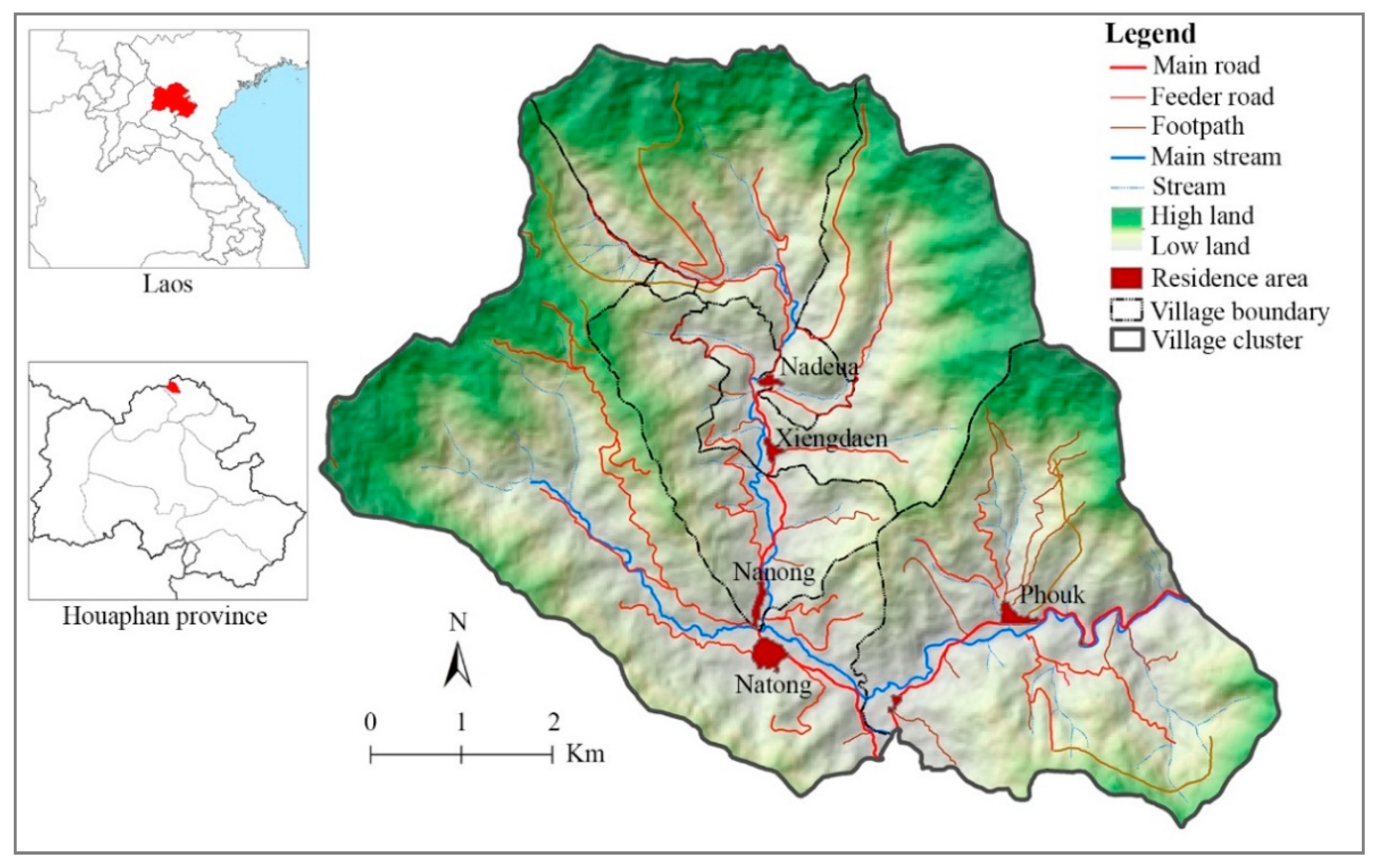
The northern uplands of Laos make up 60% of the country’s territory and are home to 35% of the national population, thereby resulting in a relatively low population density of about 20 people per km2. Huaphanh is one of the provinces belonging to the northern uplands and shares a large part of its border with Vietnam (Figure 1). It is one of the poorest provinces in the country. During the Lao civil war (1953–1975), Huaphan was at the heart of the revolutionary movement because of its remoteness and mountainous, forested landscape that provided natural protection from enemy forces. The Mekong River historically constituted the primary trade and transport route for the country, thus the population and road systems are most densely established in the Mekong Basin. Huaphan, however, is the only Lao province that does not belong to the Mekong Basin and is instead located in the northeastern part of the country bordering Vietnam. The province’s main rivers, the Sam River and the Nam River, flow east through Vietnam into the Gulf of Tonkin.
Roads connecting our study site to the district and province capitals are of poor quality but have constantly improved over the last decades. Contrary to its low domestic accessibility, the area is well connected to markets and villages in Vietnam and thus maintains strong cross-border trading ties. The study area is home to four different ethnic groups: the Tai Dam, Ksing Mool, Khmu and Yao, who make up most of the population of the Xiengkhor district, and of the neighboring district on the Vietnam side. They traditionally practice subsistence agriculture with the Tai Dam (the earliest settlers) focused on paddy rice production in the valley lowlands, and with other ethnic groups who arrived more recently focused on upland rice production through shifting cultivation of the upland hillsides [35].
2.2. Methodological Framework
We view the maize boom as the mechanism which introduced emerging capitalist relations of production in remote farming communities [24]. The boom triggers and then reinforces the processes at work in a regime shift between two different agrarian systems, i.e., from subsistence to market-oriented agricultural production [36,37]. We examine the commodity boom as a specific lens through which to investigate larger societal transformations and their complex patterns of causality [4,38,39,40]. Longitudinal studies in a set number of case study sites tracked transformations of landscapes and livelihoods along local development pathways. Together with local stakeholders, we developed narratives to explain the land-use patterns resulting from multiple processes, understood as sequences of events and conjunctures [18,24,41]. We then related these narratives with data analyses from household surveys and remote sensing to quantify the impacts of land-use changes on local livelihoods (Figure 2).
2.3. Data Collection and Analysis
Field research took place during two successive extended periods spent in the study sites in 2009 and 2016. During each period, a group of researchers and local extension agents worked and lived in the villages. The studies concentrated on changes in land uses and livelihoods, first in the 2000s and then in the 2010s. These periods were important as they corresponded to successive stages in the maize boom-bust cycle [34]. The period from 2004 to 2009 marked the first phase of maize expansion and was captured by the study conducted in 2009. The period from 2010 to 2016 coincided with a second phase of maize expansion along a feeder road network constructed in 2008–2010 to reach remote parts of the village territories. We studied this second phase in 2016. Finally, the impact of the 2016–2017 road expansion was monitored in 2019 through key informant interviews.
Data collection combined three complementary approaches: (i) land-use change analysis through remote sensing and participatory mapping, (ii) livelihood analysis through individual interviews and focus group discussions, and (iii) scenario exploration with local land-users through gaming-simulations. We used Landsat satellite images of 2003, 2008, 2013 and 2015 to generate a chronological series of land-use maps (Appendix A). In addition, we conducted ground truth surveys in 2009 and 2016 and we used a SPOT image and aerial photographs (2015) for supervised pixel classification and accuracy assessment (Appendix A).
We collected socioeconomic data through focus group discussions (stratified random sampling of 15 persons per village representative of the different ethnic groups, genders, and socioeconomic status), field observations (walking transects across village territories and measurement of selected farmers’ fields), and key informant interviews (village heads and members of the village committee, traders, and teachers). A survey of all 360 households in the five villages of Natong village cluster was conducted in 2009 and 368 households were surveyed in 2016. We collected quantitative data about household composition, agricultural practices (technical and economic performances), household assets, and income structure. Based on these data, we quantified the changes in terms of livelihood capital (financial, natural, human, social, physical) [42] and categorized farming systems through principal component analysis and clustering [35]. Then we conducted a more detailed survey on a randomly selected sample of 30% of the village households, both in 2009 and in 2016. We collected qualitative data about historical changes in land-use and especially maize cultivation dynamics, i.e., year of introduction, evolution of land, labor and capital invested in this crop production, relationships with traders, and main problems encountered. In addition, focus group discussions addressed issues related to transformations of local institutions and infrastructures, to land tenure and management, to the demise of upland rice-based swidden systems, to access to market and contract farming, construction of maize feeder roads, and local perceptions of land degradation and ecosystem services (Figure 2).
Finally, we used role-play games to investigate issues of great concern for the local population and to elicit local knowledge on, e.g., negotiations that took place for the construction of maize feeder roads (Appendix B).
3. Results
3.1. Road Construction and Land-Use Intensification
3.1.1. Influence of Government Policies on Land-Use Dynamics
The origins of the maize boom are rooted in previous rice-based land-use dynamics. Before the introduction of cash crops, lowland agriculture was the main source of wealth in the study area. As the key staple food core to the traditional livelihood systems, rice production historically received the most attention from the GoL. The Natong village cluster historically combined a tiered ethnic spatial organization and a concentric distribution between the center (Tai Dam villages) and the periphery (Ksing Mool, Khmu and Yao communities) of the watershed. Originally, Tai farmers produced rice in lowland paddy fields managed by the community and regularly redistributed among the households according to their size. This redistribution system of land-use rights buffered inequalities within communities. Besides community paddies, farmers established terraced paddy fields that were privately held. Social disparities were rooted in paddy ownership. With the terracing of paddy areas in the 1980s and 1990s, farmers reached the geographic limit of paddy expansion [35]. The improvement of the irrigation systems then increased land-use intensity, and therefore production, for some farmers. However, with population increase, the paddy area grew increasingly insufficient to meet rice needs; farmers had to produce additional upland rice through shifting cultivation.
After the end of the war in 1975, one of the first policies of the ruling Communist Party was to integrate the highlands communities by relocating them close to the valleys and promoting agricultural intensification in lowland areas. This policy led to the resettlement of the Khmu and Ksing Mool communities to the lowlands where Tai farmers traditionally lived, therefore reorganizing the spatial distribution of the different ethnic groups. The GoL attempts to collectivize agriculture at the end of the 1970s, had a very limited impact on the farming systems in Tai-dominated areas as community management of the paddy fields and labor sharing for weeding or transplanting already existed under the traditional Tai system. However, the decollectivization policy of the 1980s disrupted the muong system in the Tai villages that had previously incorporated other ethnic groups. The population density also increased throughout the 1980s; hence, the individual share of muong paddies had decreased, the de-collectivization process became a pretext to discontinue the land redistribution system and privatize the communal muong paddies.
After successive lowland policies, the government turned its attention in terms of development planning to the uplands in the mid-1990s, especially for forest protection and poverty alleviation. Government officials considered the eradication of slash-and-burn agriculture the best way to break the vicious circle of environmental degradation while lifting upland populations out of poverty [1,12,43]. With increasing population density and shortening fallow periods, the shifting cultivation system had entered a cycle of land degradation and food insecurity [31,32,35]. Development programs promoted a new wave of resettlement to move the most remote villages closer to ‘focal development areas’ equipped with markets, schools and health centers [28,30]. In line with this logic, large projects of the World Bank, the Asian Development Bank and other donor agencies supported road infrastructures as an avenue to commercial agriculture viewed as modern while shifting cultivation was considered as backward [3,44].
3.1.2. The Rural Road Brought the Maize Market
The construction of roads was the spark that ignited a wave of development changes in our study site and throughout Xienghkhor district. Like the other 46 poorest districts in Laos, Xiengkhor district received strong support from the Poverty Reduction Fund (PRF), a national agency partly financed by the World Bank. Between 2003 and 2008, the PRF improved road access, built water supplies, constructed schools, financed concrete irrigation canals, and built a small bridge across the river. These infrastructures dramatically changed local livelihoods. In line with the government policy to alleviate rural poverty, local authorities supported private companies, both domestic and foreign, to invest in maize production, leading 80% of the 62 Xiengkhor villages to generate their main income from maize [19]. For example, the Xiengkhor district governor exempted maize traders from paying taxes on foreign investment and on exports to Vietnam. He paid several visits to the governor of Yen Chau district, the district bordering Xiengkhor in Vietnam to strengthen commercial and social ties with neighboring communities. Vietnamese traders promoted alternatives to rice-based shifting cultivation called upon by the GoL, in the form of hybrid maize that was booming in Vietnam as a response to high demand from the feedstock industry.
As maize was already a successful cash crop on the other side of the border, success stories spread by word of mouth between relatives living on the other side. In 2005, yields were high and traders came to buy directly from Lao farmers. The high initial earnings of first movers in maize encouraged other farmers in the area to follow suit and plant maize, and the year 2006 saw the majority of farmers engaging in commercial maize production. The Vietnamese traders came twice a year, first to provide hybrid maize seeds (LVN10) on credit and then to collect the harvest. Once registered with the district, the traders were assigned a number of villages they could do business with through a kind of monopsony system [19,35]. They signed an exclusive contract with the village head, witnessed by the district authorities that precluded other traders from doing business in their ‘allocated villages’. These contracts also secured the market access for farmers who were afraid of cultivating crops they would not have a market for. The traders then signed contracts with village intermediaries to whom they provided large amounts of seeds (1 to 2 tons) that the intermediaries then distributed among villagers, usually without any written contracts. Maize production would first dominate the most accessible areas around the villages, after which farmers would have to travel longer distances to convert dense forests into new upland fields. The introduction of maize thus sparked a subsequent rush to the uplands. Farmers turned their swidden fallows into semi-permanent maize fields, which entailed a shift to two- to three-year rotations of maize as compared to five- to seven-year rotations for upland rice swiddens.
3.1.3. The Maize Boom through the Lens of Feeder Road Expansion
After a bountiful harvest in 2006, expectations of high income from maize led to further expansion of maize areas. Village communities decided they needed a new kind of road, maize feeder roads, to reach remote fields and ease the transportation of the maize harvest. Farmers produce about 1 t/ha upland rice compared with the initial 5 t/ha for maize, meaning the maize harvest is five times heavier and thus far more difficult to transport than upland rice. Besides, the peak in labor demand for the maize harvest coincides with the busy work calendar of upland and paddy rice. The Vietnamese traders provided a solution to this constraint to agricultural expansion: they offered to construct maize feeder roads on credit, which could be repaid through future maize harvests.
In all villages, a standard written contract is applied to the loans linking the Vietnamese trader to the village community represented by its headman. The trader provided the funds to build the road and to complete any additional repairs required during the three following years. The interest for the loans was included in the amount of the loan negotiated with the farmers. The village community had to pay back the loan within three years by selling maize exclusively to their trader at an agreed price, typically below the market price. The village council managed the communal debts directly with the farmers according to methods of calculation specific to each village. In Xiengdaene, for example, every household is paid according to the number of people in the family. This way, the road debt became a village tax engaging the whole community. In Natong, farmers’ dues depended on their maize cropping area and access to the road; for example, a farmer using a field far from the road would pay less. In this case, the road debt resembled a production tax. These maize production arrangements emerged within a few months after the road construction, and differed from village to village. We used simulation games to investigate the nature of the negotiations that took place during this period in different villages and to understand how their outcomes influenced the local management rules (Appendix B).
Finally, two main actors were involved in the construction of two road types. On the one hand, the local government supported by development agencies such as the Asian Development Bank or the World Bank, developed a network of rural roads linking villages together and with administrative centers and economic services. Rural roads aimed at reducing poverty, enhancing food production, and increasing household income. On the other hand, private investors from Vietnam provided financial (loans reimbursed in-kind) and technical (excavators and terracing engines) support to local communities to develop a dense network of narrow feeder roads that reached all corners of their village territories. Feeder roads constructed by private Vietnamese investors aimed at maximizing their profits through contract-farming arrangements, including exclusive supply of agricultural commodities to reimburse for the road construction.
3.2. Road Construction Cycles and Land Degradation
3.2.1. The Governance of Roads and Crops Expansion
On paper, the official regulatory procedure preceding the construction of a feeder road involves multiple steps. Villagers are expected to first agree on where they would like to build a road. The village head and committee then survey the area together with the trader to agree on a total fee for road construction. The village head introduces the project to three district government offices: the Department of Public Work and Transportation, the Department of Natural Resources and Environment, and the Department of Agriculture and Forestry. The district authorities may conduct another field survey to ensure that the road would not violate any regulations (e.g., run through a protected area or interfere with a government project). After receiving an official agreement from the three departments, the village head can sign a contract with the maize trader on behalf of the villagers. While these regulations apply to the construction of all feeder roads, the comparison of our field data with the official registers of the district showed that more than half of the feeder roads were not registered at the district level. The official regulations often lagged behind the rapid institutional changes (i.e., informal practices and norms on the ground) brought by the sudden need of formerly subsistence-focused communities to access markets. Most investments in road construction and related arrangements described here above happened ‘uncontrolled’ during the periods of increasing maize prices (i.e., 2007–2008 and then 2016–2017).
In 2008, the maize price fell sharply in connection with the global financial crisis and many farmers stopped growing maize. Some villages had trouble repaying their road-related debts on top of the maize production debts, as the maize price was lower than its production costs. Negotiations took place with traders to ease the terms of repayment for road construction loans, especially by expanding the credit period and allowing farmers who stopped growing maize to make cash payments instead of paying through maize sales. These debt arrangements reinforced the dependency that already existed in the monopsony contract between the traders and the village communities.
Maize stakeholders, i.e., village communities, traders, government agencies, constantly renegotiated local regulations, each village learning from the arrangements found in neighboring villages. Consequently, some roads were registered, some were not. Moreover, traders placed high pressure on some villagers to repay their debts, while in other villages, the roads were not reimbursed because of poor maintenance by the traders, which was considered a breach of the initial contract. When maize prices were high, the trader committed to providing the hybrid maize seeds, buying the whole harvest produced by the village, and repairing the feeder roads. In 2014, during a period of low maize prices, some traders did not fix the road properly; the trucks could not reach some production areas and they did not collect maize harvest in some areas, therefore increasing tensions between the traders and maize producers. For some villages, market integration brought by the roads was brutal and suddenly imposed new codes and norms upon a local economy that departed from those foundational to a subsistence economy. Ultimately, what made the difference between villages is their capacity to negotiate the road for their own interest.
3.2.2. Impacts of the Maize Boom on Landscapes and Livelihoods
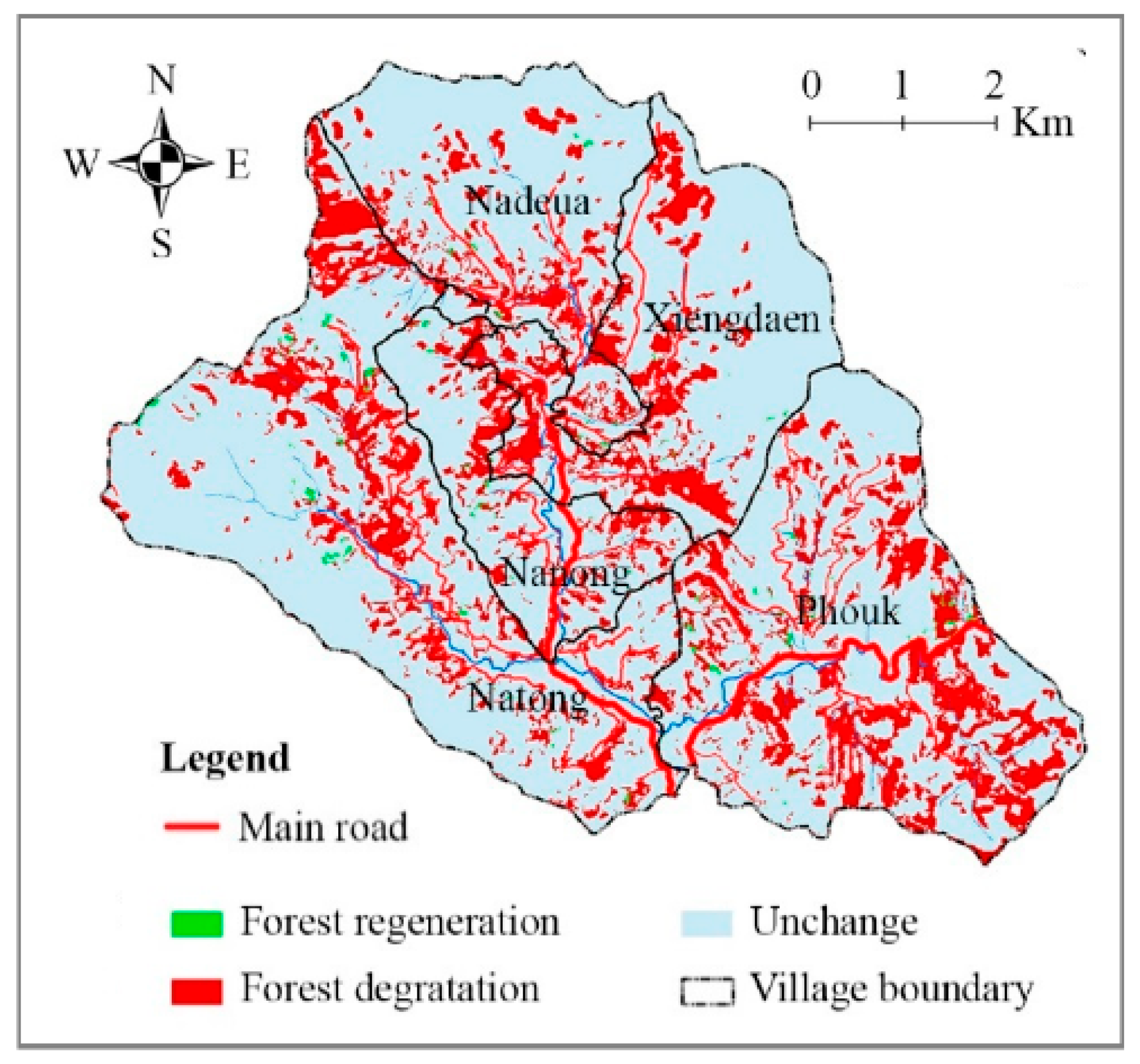
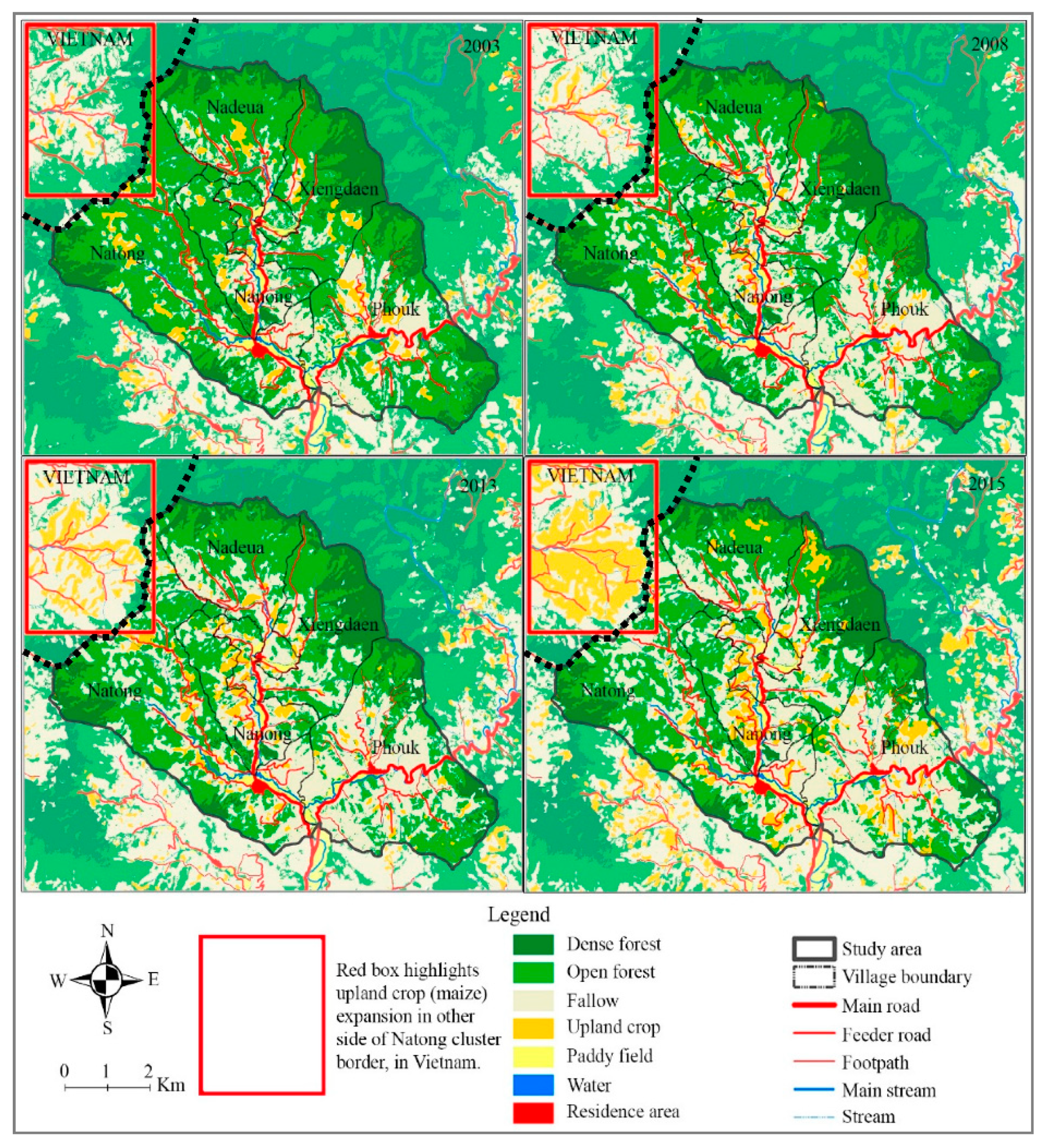
As feeder roads were reaching remote hillsides, maize gradually expanded along those roads at the expense of the forest. This destructive process broke the traditional land management rules that restricted the expansion of pioneer shifting cultivation. However, soils of old-growth forests recently cleared through slash and burn techniques were particularly fertile, which resulted in high maize yields, and consequently, the ability to rapidly repay the debts incurred for the maize roads. Maize expansion thus led to dramatic deforestation, as shown in Figure 3. Large tracts of open forests were converted (74% of the area in 2003 to 54% in 2015) to maize fields and fallows (Figure 4). However, because of the relatively low population density, farmers of Natong area had not yet reached the forest frontier in 2015, unlike their Vietnamese neighbors from the village located north-west of our study site (Figure 5).
In the study site, we observed two patterns of land-use intensity with maize grown under a rotational system that involved a short 2 or 3 years fallow, while in most accessible areas, close to the feeder roads, farmers were cropping their plots almost continuously. Land degradation grew due to these shortening fallow periods, which in turn affected maize yields [45,46]. Farmers initially offset their productivity losses by expanding the cropped area to maintain the same level of production. However, rises in weed infestation under shortening fallow period [47,48] absorbed their labor force in case of manual weeding or increased production costs in case of herbicide spraying and therefore reduced their capacity to expand the crop. Farmers started using herbicides in 2014. The first year they hired Vietnamese workers to spray, as they did not know how to do so themselves. In subsequent years, villagers began to apply herbicides themselves. Many households also started using chemical fertilizers at the same time as herbicides on both maize and upland rice.
The few households who were using animal manure as fertilizer in the paddies stopped doing so. Applying chemical fertilizer was convenient and their main source of animal manure was disappearing. Hand tractors gradually replaced buffaloes for plowing the paddy land as villagers could afford to buy machinery with the money they earned from maize. Tensions over the shrinking areas available for livestock grazing livestock and damages caused to maize by wandering livestock also led many farmers to sell their animals, therefore increasing their economic dependence on maize production.
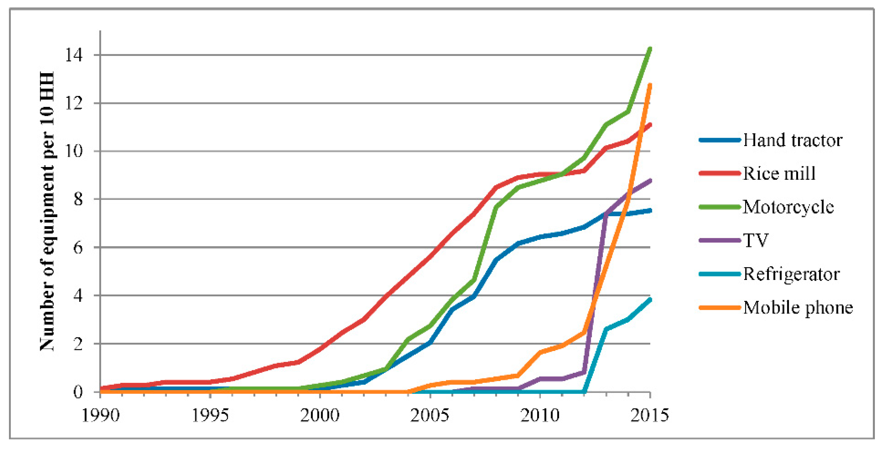
The year 2014 was a turning point in the history of the study area. Quality of life had improved thanks to maize production, as shown by increased household consumption and accumulation of assets in Figure 6, also related to the connection of the villages to the electricity grid in 2013. While all households in Natong cluster eventually became engaged in maize production, the crop had different impacts on household wealth [35]. The households that were better off even before the maize boom tended to hold considerable paddy land and were, therefore, rice-sufficient in 2005. They had engaged earlier in maize production, committed larger areas to it, and therefore made more gains in wealth than other households did. Households previously unable to produce enough rice for their own sustenance, in contrast, found that maize occupied most of their labor force, therefore, putting their food security at risk. Their economic dependency on local intermediaries for both maize input supply and rice purchase trapped them in debt and risk of losing their land in case of crop failure. Meanwhile, the better-off farmers could use the capital accumulated through maize cultivation to diversify their activities (e.g., into new livestock systems, off-farm opportunities) and hired labor from the poorer households to work across this range of activities.
Although average incomes had increased on average, some farmers had dramatically lost out while others had become far wealthier, and both groups were in search of alternatives, as they knew that maize systems were not sustainable. Indeed, the overall economic situation was worse in 2015 than in 2008 (Figure 7). Years of monocropping and focus on a single commodity had significantly reduced their economic activity portfolio, therefore affecting their capacity to recover from bad maize harvests using income from other agricultural activities (e.g., livestock, paddies, non-timber forest products). On-farm surveys combined with participatory and remote sensing mapping showed that forest and land degradation, i.e., fertility loss and weed infestation, associated with maize monocropping had reduced the performances of all cropping systems through significant yield decreases despite gradual increases in input use and production costs [35,45,46].
Off-farm activities developed as main diversification option for both the better-off farmers who were eager to reinvest their maize-earned capital, and for worse-off farmers who searched for employment with the former or migrated as strategies of distress diversification. Off-farm activities played a key role as economic buffers in times of risky innovation (Figure 7). Some farmers invested the capital they earned from maize in trading activities or opening a grocery in the village as an additional source of more regular income. The poorer households have had to work for others or move to other villages in search of seasonal agricultural work as a flexible cash earning option. Over our study period, the percentage of households working for someone else increased from 30% to 60% of the community, while the percentage of households who were rice sufficient for more than 6 months dropped from 70% to 20%.
3.2.3. Lessons Learnt from the Maize Boom
In 2016, our second extended visit in the study area coincided with the late stage of land-use intensification around the feeder roads constructed in 2007–2008. Agricultural development was at a crossroads facing the issues of land degradation and economic vulnerability in the larger context of road expansion and forest loss. Villagers clearly perceived the negative impacts of the maize system on their environment, but they had not reacted to it yet. The concept of opportunity windows characterizes these ‘expansion periods’ of the boom cycle when external interventions are constrained by the perception of local actors that the crop boom will last forever [4,34]. Despite the lessons learned from the maize bust, farmers were not clear about which direction to go.
The scenarios we explored with local stakeholders during our first diagnostic study in 2009 (e.g., conservation agriculture practices, on-site processing of maize for pig feeding), to maintain the revenue of farming households despite decreasing maize productivity had not translated into concrete behavioral changes. When digging more into the reasons for not bringing alternative practices to scale, we found that until 2014 local communities were not ready to change their practices for different reasons. The better-off farmers had adapted to the decreasing maize productivity by expanding their cropped area and hiring the labor force of other landless farmers, so absorbed surplus labor. The wealthier had the capital to absorb risk and adjust to natural/market downturns; the poorer were constantly rushing to catch up. In short, those who could turn away from maize were sheltered from the negative impacts of not doing so, and those who really could not afford the negative impacts of maize could not afford to change. The system was locked in, not sustainable but resilient.
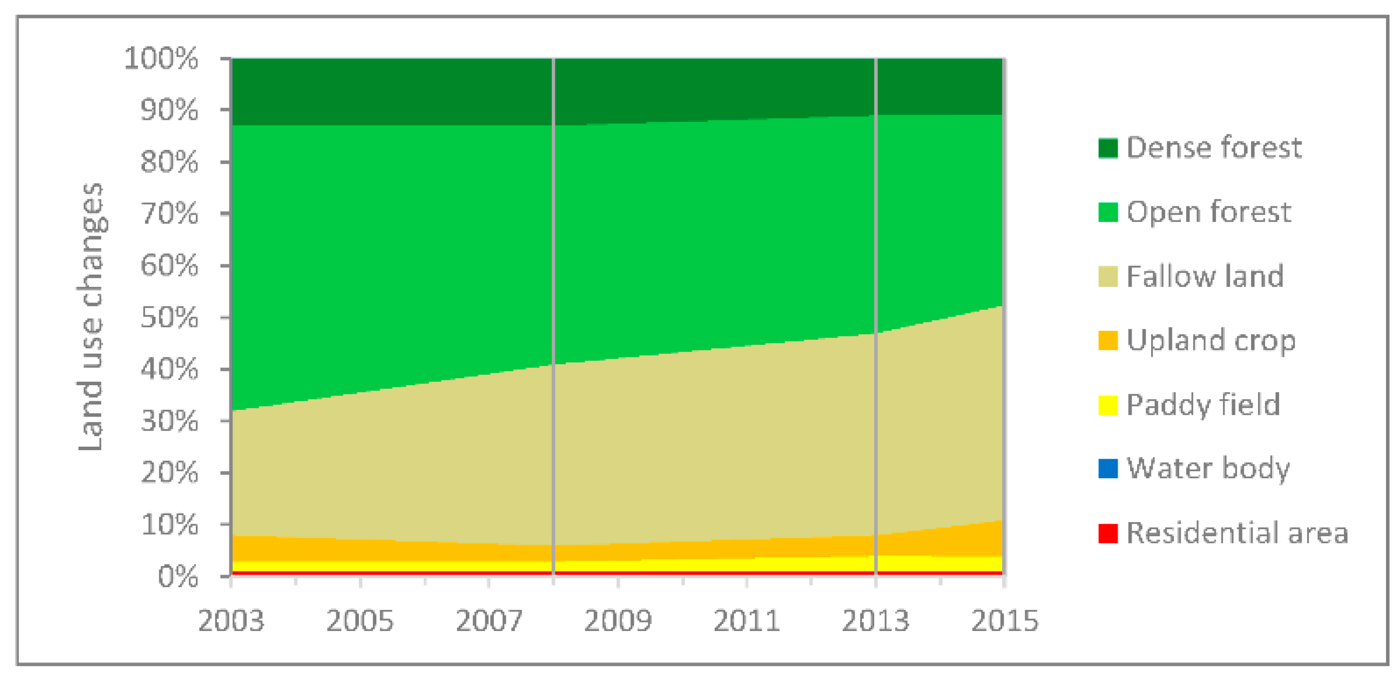
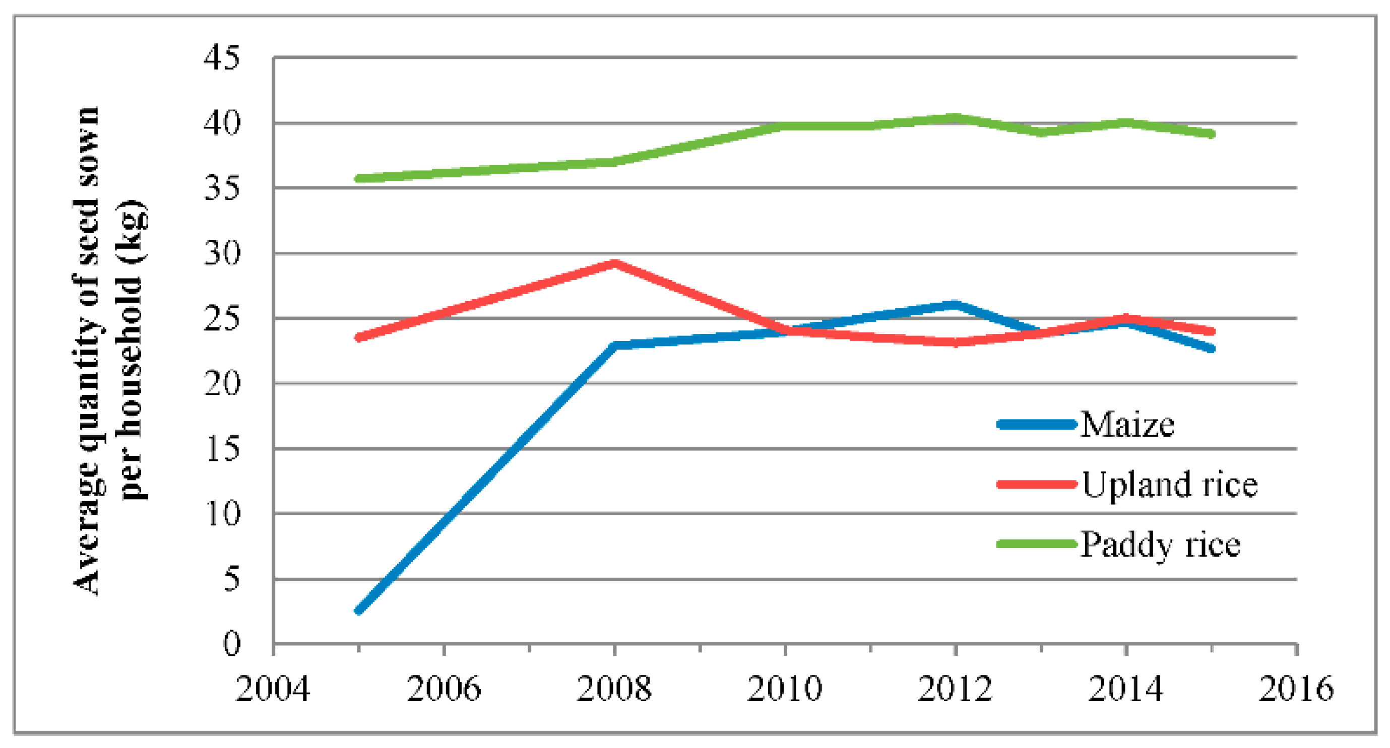
As expected, in 2016 many farmers still depended on maize cultivation to reimburse their debts. As local intermediaries were also village elites, they could negotiate extensions of the maize feeder roads in 2015 and 2016 (more than 10 km) to reach the most remote areas of the village territories. This new round of road expansion only displaced the problem of land degradation due to maize monocropping toward the forested areas newly served by the roads in the upper part of the watershed. By claiming additional agricultural land at the expense of the last forest patches, they were buying time to find alternatives practices. Even with the new roads, the total maize area remained the same (Figure 8). Farmers abandoned maize cultivation in exhausted soils close to the village and moved to the newly opened, more distant fields. There was little room for innovation as the opportunity window closed again for a while with the expansion of maize monocropping further away inside the village territories.
4. Discussion
4.1. Land-Use Intensification as a Gateway to Agrarian Capitalism
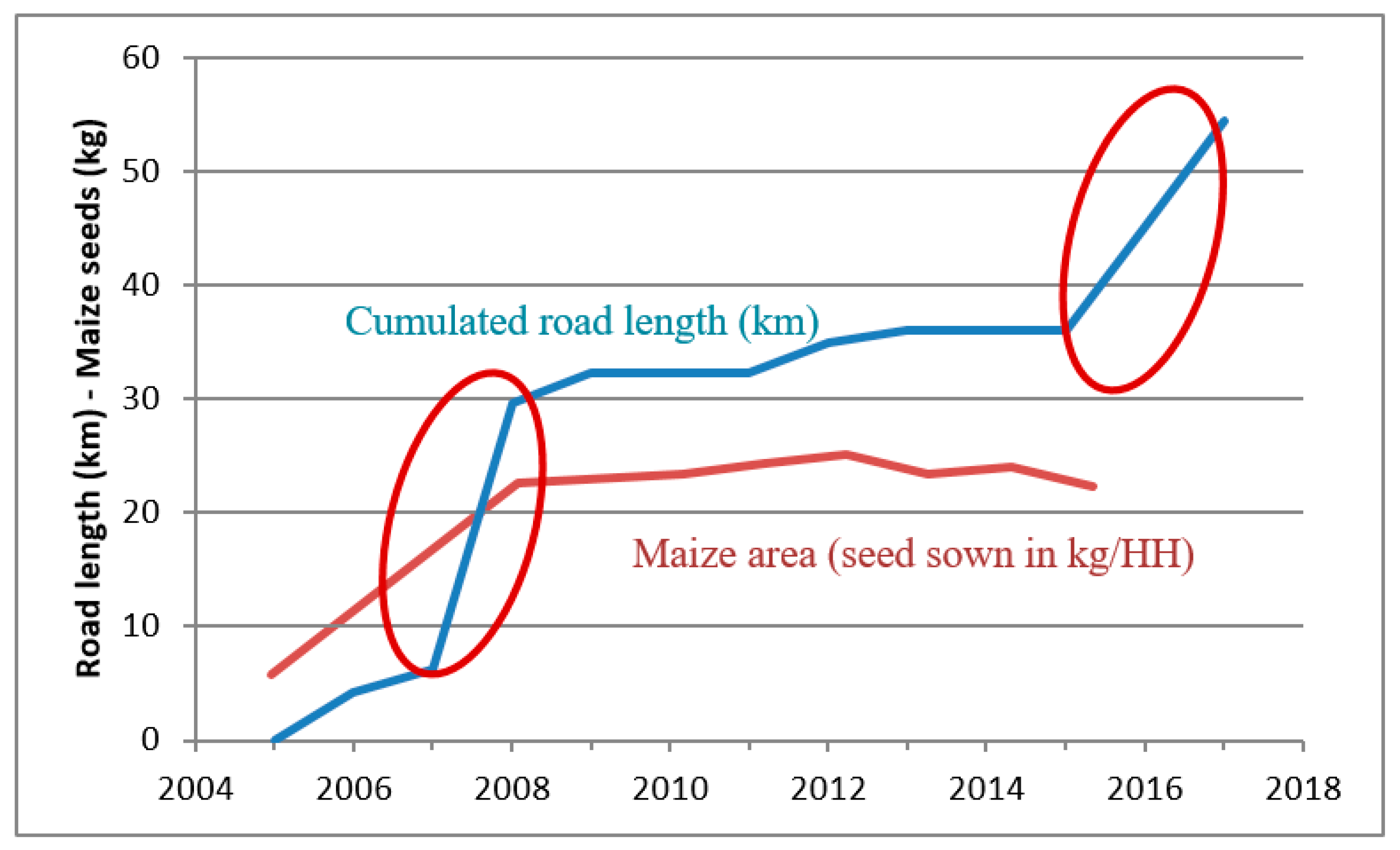
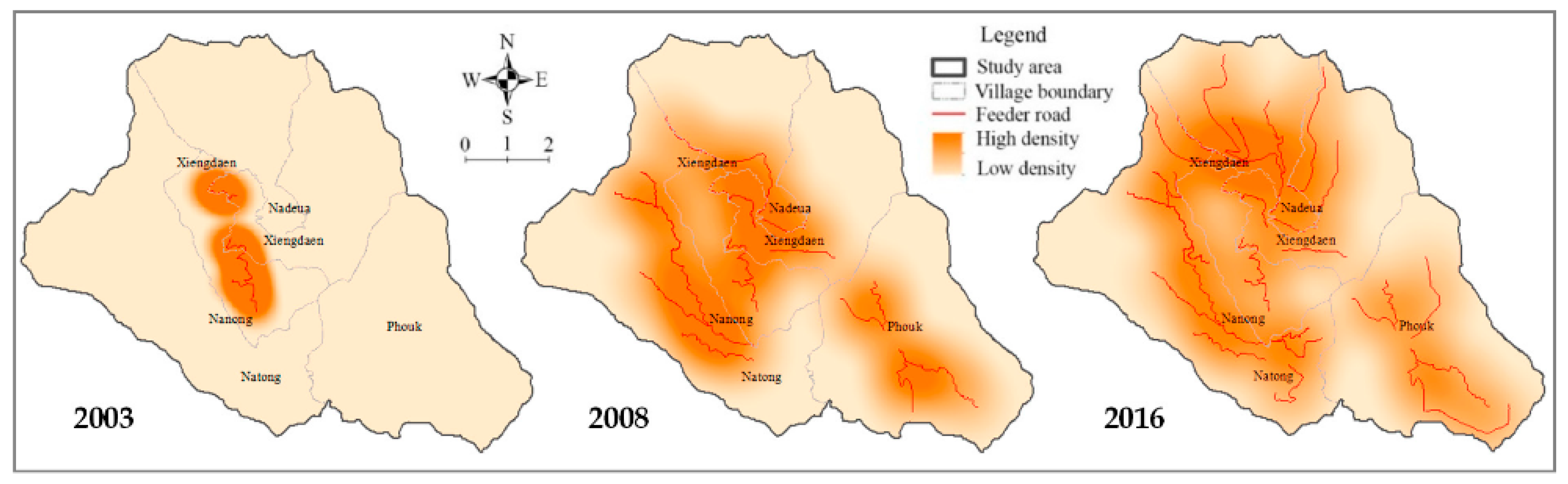
Village communities began to invest in maize feeder roads in 2007–2008, which in turn encouraged all households into maize production. In 2016–2017, a new round of road construction took place in all villages of the study area (Figure 9). The density of the feeder road network increased again (Figure 10), enabling a second wave of maize expansion, while the maize production remained stable or even decreased over the same period. Once the feeder roads had engaged former subsistence farmers into commercial maize production, turning back to shifting cultivation was not an option. To maintain their income despite decreasing maize yields, they gradually expanded the area under cultivation. Farmers’ investment in feeder roads made the land rush possible, which further increased their debts and their dependency on local intermediaries and Vietnamese traders.
This observation echoes other crop boom stories such as Mahanty & Milne (2016) in the case of cassava in Cambodia who showed how credit is creating dependence. The transition from casual market engagement to all-encompassing capitalist relations [18] brings a loss of choice at least during the time when the crop boom goes full-steam, and the opportunity window for alternatives remains closed.
This narrative is well known as the same process repeats itself all around northern Lao uplands [34,49,50] and also in neighboring countries: Myanmar [17], Cambodia [16], Vietnam [51], Thailand [46]. During our focus group discussions, participants mentioned several times that they were ready to produce whatever commodity they could market, making them easy prey for a new boom crop. Now, fully embedded in the market economy, they face large economic uncertainty that framed their risk aversion in a context of rapid changes. The perception of market stability (i.e., demand size and price volatility) became an important condition for households to invest in alternatives to maize such as tree plantation or livestock production.
The decade of integration to the market economy was associated with changes in market structures, land-use policies, prevailing development discourses, and environmental factors. The agrarian transition resulted in highly dynamic land-use changes and the emergence of new relations of production, value chains, and social network. Grasping these dynamics, underlying processes, and resulting patterns, is crucial in any effort to plan transformative action and guide development pathways towards more sustainable outcomes [52].
4.2. Land-Use Plans and Road Construction Cycles
Our case study showed that negotiations to build the feeder roads and especially land redistribution along those roads drew on deliberative processes and consensus-building (Appendix B). The outcomes of these negotiations were specific to each village depending on individual agency, imitative behaviors and social cohesion in the village communities. Local communities may use the feeder roads to restore their degraded landscapes through, e.g., domestication of non-timber forest products, afforestation of riparian areas to protect water sources. The status of the feeder roads would then change from an instrument of unregulated crop expansion to a support for spatial reorganization under a collectively negotiated land-use plan.
In contexts of forest frontiers, farmers tend to reinvest their labor productivity gains from technical innovations, e.g., herbicides, mechanization, in further expansion of the boom crop despite the constraints on forest conservation imposed by land-use plans. Under the pressure of development discourses, the regulations on feeder road construction were neither well controlled nor enforced. Land-use planning, a key instrument for managing trade-offs between policies and regulating the competition for space at the village level, faced similar pressure as road regulations [53]. However, when implemented properly, PLUP is a powerful tool to manage the trade-off between competing policies at the community level [30,54,55,56]. PLUP takes into account local specificities and peoples’ aspirations to explore sustainable development pathways and then to engage village communities in transformative landscape approaches [54,57].
Land-use planning can be used to negotiate the local trade-offs and to mitigate the negative consequences of land-use changes on fragile upland environments [30]. However, once the ‘big decisions’ are made, such as building a new road, creating a national park or an economic concession, local actors are left with only ‘small decisions’ on arrangements to, for example, protect vulnerable household groups and forest resources or preserve land-use options for future generations. In many cases, road construction plans are imposed from above and thus non-negotiable in the land-use planning process. As rural roads offer enabling conditions for crop booms to unfold, preventive measures to crop booms should include local regulation in road construction instead of using curative tools once roads are built, unregulated. We therefore advocate the inclusion of rural road negotiations in land-use planning processes.
5. Conclusions
Market integration brought by the roads was brutal in some villages as it suddenly imposed new codes and norms upon an economy of subsistence. Unpreparedness led to widening inequalities between groups within the communities. However, in the aftermath of the maize boom, when local communities are competing for scarce resources and in search of livelihood alternatives, roads and associated market integration may provide livelihood-enhancing opportunities through access to external resources (economic, social, information, education, etc.), rather than undermining them. Finally, whether roads do harm or good to local livelihoods lies in the capacity of local communities to negotiate the road for their own interest.
What makes the difference at present is that during the earlier stage in local development, the farmers have learned lessons from the crop boom. In the aftermath of the maize boom, they are fully aware of the negative impacts of the degraded status of their land that further reduces their range of opportunities. They are exploring alternative income-generating options and opportunities for innovation to open again. A large range of options that went ignored during the boom have emerged. It is thus the right time to break the vicious circle of crop booms described in this paper by exploring alternative development pathways. Communities are better equipped to turn the roads to their advantage by tapping external resources in the form of new development opportunities.
Author Contributions
Conceptualization, J.-C.C.; methodology design and data collection, J.-C.C. and S.P.; analysis of remote sensing data, S.P.; analysis of socioeconomic data, J.-C.C.; writing, J.-C.C. assisted by S.P.; project administration and funding acquisition, J.-C.C. All authors have read and agreed to the published version of the manuscript.
Funding
This research was funded by OXFAM Hong Kong, by the European Commission (EC) ‘Global Climate Change Alliance’ and the French Agency for Development (AFD).
Acknowledgments
We thank the local people in Natong area for spending their time and sharing their knowledge with us. The longitudinal research was made possible thanks to a long term partnership between NAFRI (National Agriculture and Forest Research Institute, Ministry of Agriculture and Forestry (MAF), Vientiane, Laos), DALaM (Department of Agricultural Land Management, MAF, Vientiane, Laos), CIRAD (French Agricultural Research Center for International Development, Montpellier, France) and IRD (French Research Institute for Sustainable Development, Montpellier, France). The second author gratefully acknowledges the support from Shi Guoqing from the Hohai University in China. We are especially grateful to Juliet Lu for her thorough review of an earlier version of this paper.
Conflicts of Interest
The authors declare no conflict of interest.
Appendix A. Analysis of Remote Sensing Data

Table A1.
List of remote sensing data used.
| Year | Satellite/Sensor | Acquisition Date | Sources of Images |
|---|---|---|---|
| 2003 | Landsat 7/ETM+ | 10 April 2003 | glovis.usgs.gov (accessed on 22 March 2021) |
| 2008 | Landsat 7/ETM+ | 2 January 2008 | glovis.usgs.gov (accessed on 22 March 2021) |
| 2013 | Landsat 7/ETM+ | 20 March 2013 | glovis.usgs.gov (accessed on 22 March 2021) |
| 2014 | Aerial Photo | 2014 | National Geographic Department of Laos |
| 2014 | GoogleEarth | 15 May 2014 | GoogleEarth |
| 2015 | Landsat 8/OLI | 18 March 2015 | glovis.usgs.gov (accessed on 22 March 2021) |
| 2015 | SPOT7 | 31 March 2015 | Ministry of Agriculture and Forestry, Laos |
Table A2.
Land-use and land cover categories.
| Code | Categories | Description |
|---|---|---|
| 1 | Dense forest | This refers to forestland of native species, where there are no clearly visible indications of human activities and the ecological processes are not significantly disturbed. |
| 2 | Open forest | This refers to an area of forest regenerated largely through natural processes after significant human or natural disturbance of the original forest vegetation. This category includes the areas of mixed woody with bamboo and old fallow. |
| 3 | Fallow land | This refers to vegetation types where the dominant woody elements are shrubs i.e., woody perennial plants, generally more than 0.5 m and less than 5 m in height at maturity and without a definite crown. |
| 4 | Upland crop | This category refers to land area in higher slope which is mainly used for dry cropping such as upland rice, maize, etc. |
| 5 | Paddy field | This category refers to paddy fields in both dry-season and wet-season valley-bottom fields. |
| 6 | Water body | This category includes land that is covered or saturated by water for all or part of the year and that does not fall into the forestland, cropland, grassland, or settlements categories. It includes reservoirs, natural rivers, and ponds. |
| 7 | Residential area | This category includes all developed land, including transportation infrastructure and human settlements of any visible size. |
Table A3.
Result of accuracy assessment for land-use and land cover map of 2015.
| Classified Data | Reference Data | C-Total | Num. Correct | PA (%) | UA (%) | (K^) stat. | ||||||
|---|---|---|---|---|---|---|---|---|---|---|---|---|
| DF | OF | FL | UC | PF | WB | RA | ||||||
| DF * | 30 | 3 | 1 | 0 | 0 | 0 | 0 | 34 | 30 | 96.77 | 88.24 | 0.86 |
| OF | 1 | 93 | 9 | 2 | 0 | 0 | 0 | 105 | 93 | 86.92 | 88.57 | 0.81 |
| FL | 0 | 9 | 62 | 0 | 0 | 0 | 0 | 71 | 62 | 74.70 | 87.32 | 0.81 |
| UC | 0 | 2 | 11 | 34 | 0 | 0 | 0 | 47 | 34 | 94.44 | 72.34 | 0.68 |
| PF | 0 | 0 | 0 | 0 | 15 | 0 | 1 | 16 | 15 | 100 | 93.75 | 0.93 |
| WB | 0 | 0 | 0 | 0 | 0 | 2 | 0 | 2 | 2 | 100 | 100 | 1 |
| RA | 0 | 0 | 0 | 0 | 0 | 0 | 5 | 5 | 5 | 83.33 | 100 | 1 |
| R-Total | 31 | 107 | 83 | 36 | 15 | 2 | 6 | 280 | 241 | 90.88 | 90.03 | 0.81 |
| Overall Classification Accuracy = 86.07% | ||||||||||||
* DF = Dense forest; OF = Open forest; FL = Fallow land; UC = Upland crop; PF = Paddy field; WB = Water body; RA = Residential area; R-Total = Reference Total, C-Total = Classified Total, PA = Producer Accuracy, UA = User Accuracy.
Appendix B. Role-Playing Game about the Construction of Maize Feeder Roads
Appendix B.1. Background
The narrow roads constructed along the hillsides of the Natong area contributed to the rapid increase in maize production from 2005 to 2009. These roads were built by Vietnamese traders for 1 to 1.2 million kip per km, paid by the villagers. A total of 35 km of these roads has been constructed in Natong village cluster in recent years for a total cost of 370 million kip. Vietnamese traders provided three-year loans to the farmers. How could these farming communities, which are among the poorest in the country—Xiengkhor is one of the 47 poorest districts identified by the government to target poverty alleviation interventions—afford such an expense?
A cost–benefit analysis shows that the labor constraint or labor cost involved in carrying the maize production to the village is reduced by the road, which allowed communities to expand the maize area, to increase total production and thus to reimburse the cost of the road. Who paid for the road? How was the total cost shared among the members of the village community?
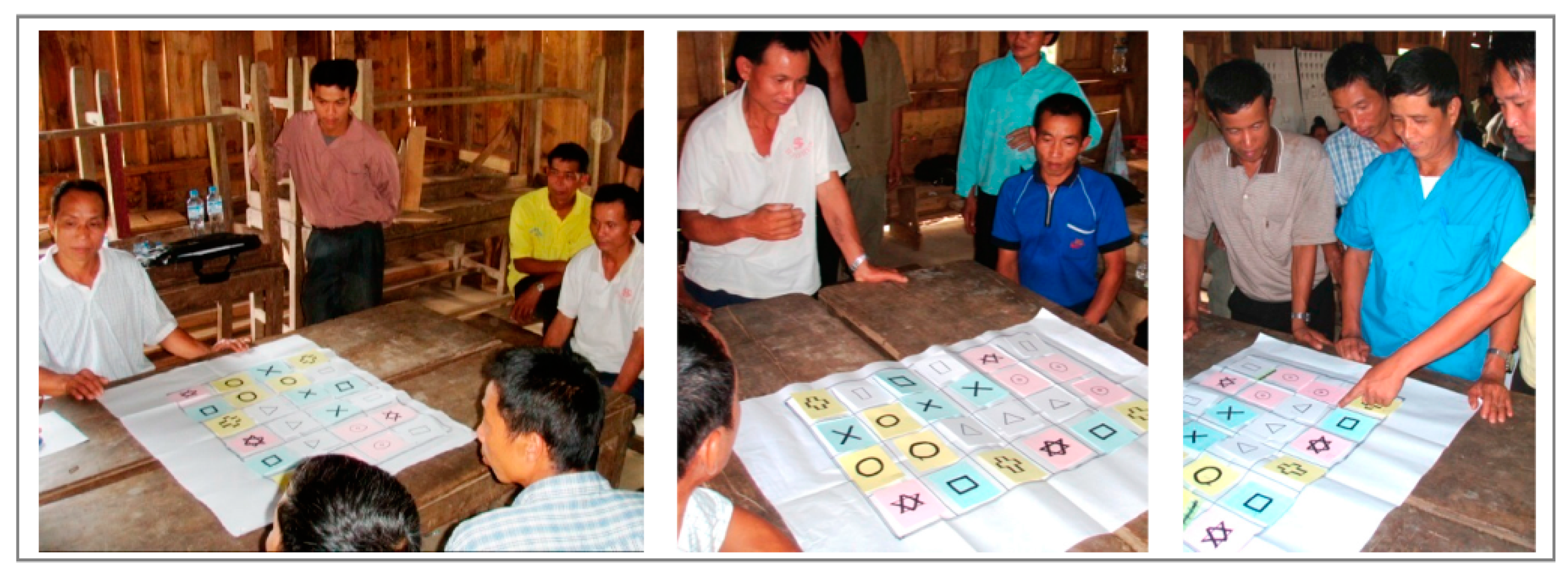
The serious game aimed at investigating the emergence of local arrangements of production in relation to maize expansion within the community.
Appendix B.2. Description of the Game
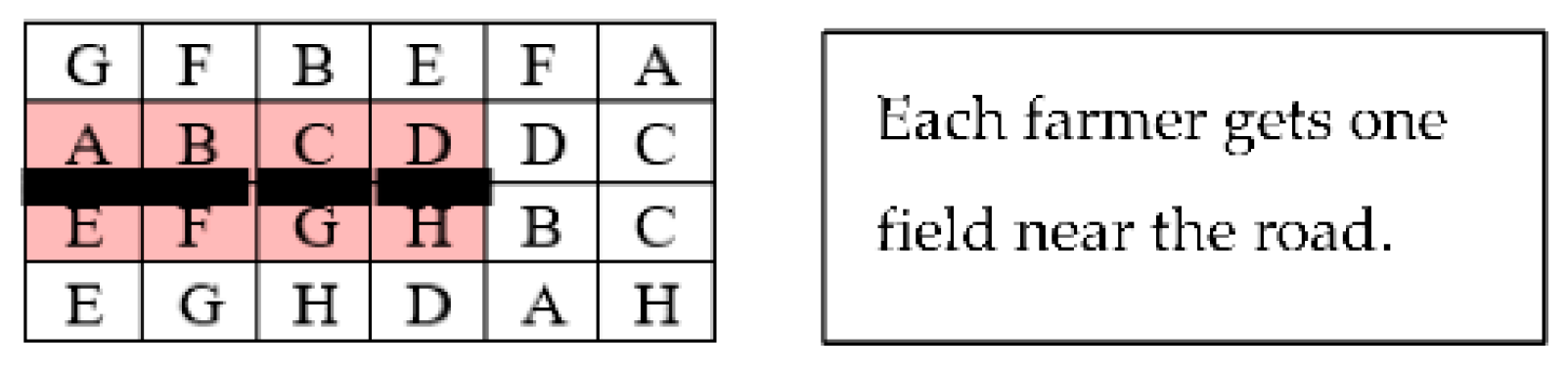
Eight farmers were selected to take part in the game so as to cover the diversity of households found in the target villages. Each player received three cards with individual marks to identify his maize plot in the area. The game board was a grid of 24 cells on which the farmers were asked to locate their maize plots. The players received long narrow cards representing road sections that were the length of the side of a grid cell. Roads could be built from the outer part of the game board (Figure A1). To represent the investment limitation, only four road sections were available. One field away from a road generates an income of 2 million kip. With a road nearby, the income could be doubled to 4 million kip. One road section costs 2 million kip shared between the two owners of the neighboring fields.
Figure A1.
Example of game board.

Appendix B.3. Group 1 (Example of Xiengdaene Village)
The players located their three maize plots in the grid cell so as to fill the game board. The village headman managed to get contiguous plots in the middle of the landscape, i.e., the area where he expected the road to pass through (Figure A2). Then, once all players had positioned their plots, the headman said the road should pass through the middle of the slope so there would be the same area above and below the road. That way, he argued, farmers would get fair access to the road. Then he told the story of their village negotiation process. Farmers exchanged plots along the maize road to get an equal share of plots with good access. He implemented the strategy on the game board and asked the other players if they agreed with the proposed plot exchanges. As everyone agreed, the game was over. The plot distribution over the landscape provided an equal share to all participants.
Figure A2.
Game board in Xiengdaene Village.
Appendix B.4. Group 2 (Example of Natong Village)
The players chose their field locations. Players A and C (the village headman and deputy of Natong) each chose three fields clustered near one side of the grid; other players chose randomly. The first attempts to build the roads came from either the A or the C side (Figure A3). Other players swiftly complained about the situation (just four players would gain access to the road). After 10 min of discussion, farmers found a compromise with four small roads giving access to the road for six players. During the discussions, the option of rearranging the land use did not arise. Even when the facilitator introduced this possibility, farmers A and C blocked the process to protect their own interests. Finally, the game ended with the last compromise leaving two farmers without access to the road.
Figure A3.
Game board in Natong Village.

Appendix B.5. Conclusions
We played the game in different villages and each time the outcomes were different (Figure A4). The village leadership was decisive in leading the negotiations toward equal or unequal distributions of land around the roads. The village heads may give up some of their advantages for the benefit of the majority or may maximize their own interest. The attitude of the village heads during the negotiation generated contrasted outcomes.
Figure A4.
Game sessions conducted in different villages.

References
- Van Vliet, N.; Mertz, O.; Heinimann, A.; Langanke, T.; Pascual, U.; Schmook, B.; Adams, C.; Schmidt-Vogt, D.; Messerli, P.; Leisz, S.; et al. Trends, drivers and impacts of changes in swidden cultivation in tropical forest-agriculture frontiers: A global assessment. Glob. Environ. Chang. 2012, 22, 418–429. [Google Scholar] [CrossRef]
- Cramb, R.A.; Colfer, C.J.P.; Dressler, W.; Laungaramsri, P.; Le, Q.T.; Mulyoutami, E.; Peluso, N.L.; Wadley, R.L. Swidden Transformations and Rural Livelihoods in Southeast Asia. Hum. Ecol. 2009, 37, 323–346. [Google Scholar] [CrossRef] [Green Version]
- Dressler, W.H.; Wilson, D.; Clendenning, J.; Cramb, R.; Keenan, R.; Mahanty, S.; Bruun, T.B.; Mertz, O.; Lasco, R.D. The impact of swidden decline on livelihoods and ecosystem services in Southeast Asia: A review of the evidence from 1990 to 2015. Ambio 2017, 46, 291–310. [Google Scholar] [CrossRef] [PubMed] [Green Version]
- Castella, J.-C. Agrarian transition and farming system dynamics in the uplands of South-East Asia. In Proceedings of the 3rd International Conference on Conservation Agriculture in Southeast Asia, Hanoi, Vietnam, 10 December 2012; pp. 4–20. [Google Scholar]
- Rigg, J. Roads, marketization and social exclusion in Southeast Asia. What do roads do to people? J. Humanit. Soc. Sci. Southeast Asia 2002, 158, 619–636. [Google Scholar] [CrossRef] [Green Version]
- Rerkasem, K.; Rerkasem, B. Montane Mainland South-East Asia: Agroecosystems in transition. Glob. Environ. Chang. 1995, 5, 313–322. [Google Scholar] [CrossRef]
- Van de Walle, D. Impact evaluation of rural road projects. J. Dev. Eff. 2009, 1, 15–36. [Google Scholar] [CrossRef]
- Demenge, J. Development theory, regional politics and the unfolding of the ‘roadscape’ in Ladakh, North India. J. Infrastruct. Dev. 2015, 7, 1–18. [Google Scholar] [CrossRef]
- Meyfroidt, P. Approaches and terminology for causal analysis in land systems science. J. Land Use Sci. 2016, 4248, 1–27. [Google Scholar] [CrossRef]
- Scott, J.C. Seeing Like a State: How Certain Schemes to Improve the Human Condition Have Failed; Yale University Press: New Haven, London, 1998. [Google Scholar]
- Warr, P. The impact of road development on poverty in the Lao PDR. Asia Pac. Dev. J. 2006, 13, 1–23. [Google Scholar]
- Heinimann, A.; Hett, C.; Hurni, K.; Messerli, P.; Epprecht, M.; Jørgensen, L.; Breu, T. Socio-Economic Perspectives on Shifting Cultivation Landscapes in Northern Laos. Hum. Ecol. 2013, 41, 51–62. [Google Scholar] [CrossRef] [Green Version]
- Epprecht, M.; Minot, N.; Dewina, R.; Messerli, P.; Heinimann, A. The Geography of Poverty and Inequality in the Lao PDR; University of Bern and International Food Policy Research Institute: Bern, Switzerland, 2008; ISBN 978-3-905835-09-0. [Google Scholar]
- Bryceson, D.F.; Bradbury, A.; Bradbury, T. Roads to Poverty Reduction? Exploring Rural Roads’ Impact on Mobility in Africa and Asia. Dev. Policy Rev. 2008, 26, 459–482. [Google Scholar] [CrossRef]
- Hall, D. Where the streets are paved with prawns: Crop booms and migration in Southeast Asia. Crit. Asian Stud. 2011, 43, 507–530. [Google Scholar] [CrossRef]
- Kong, R.; Diepart, J.C.; Castella, J.C.; Lestrelin, G.; Tivet, F.; Belmain, E.; Bégué, A. Understanding the drivers of deforestation and agricultural transformations in the Northwestern uplands of Cambodia. Appl. Geogr. 2019, 102, 84–98. [Google Scholar] [CrossRef] [Green Version]
- Vicol, M.; Pritchard, B.; Htay, Y.Y. Rethinking the role of agriculture as a driver of social and economic transformation in Southeast Asia’s upland regions: The view from Chin State, Myanmar. Land Use Policy 2018, 72, 451–460. [Google Scholar] [CrossRef]
- Li, T.M. Land’s End: Capitalist Relations on an Indigenous Frontier; Duke University Press: Durham, NC, USA, 2014; ISBN 0822357054. [Google Scholar]
- Willi, Y. Of Maize and Men. Contract Farming in the Houaphanh Province of the Lao PDR: Scale, Scope and Impacts on Peasant Livelihoods. Ph.D. Thesis, University of Bern, Bern, Switzerland, 2011. [Google Scholar]
- Junquera, V.; Grêt-Regamey, A. Crop booms at the forest frontier: Triggers, reinforcing dynamics, and the diffusion of knowledge and norms. Glob. Environ. Chang. 2019, 57, 101929. [Google Scholar] [CrossRef]
- Vongvisouk, T.; Broegaard, R.B.; Mertz, O.; Thongmanivong, S. Rush for cash crops and forest protection: Neither land sparing nor land sharing. Land Use Policy 2016, 55, 182–192. [Google Scholar] [CrossRef]
- Borras, S.M.; Franco, J.C.; Isakson, S.R.; Levidow, L.; Vervest, P. The rise of flex crops and commodities: Implications for research. J. Peasant Stud. 2016, 43, 93–115. [Google Scholar] [CrossRef] [Green Version]
- Gerber, J.-F. The role of rural indebtedness in the evolution of capitalism. J. Peasant Stud. 2014, 41, 729–747. [Google Scholar] [CrossRef]
- Mahanty, S.; Milne, S. Anatomy of a boom: Cassava as a “gateway” crop in Cambodia’s north eastern borderland. Asia Pac. Viewp. 2016, 57, 180–193. [Google Scholar] [CrossRef]
- Cramb, R.; Manivong, V.; Newby, J.C.; Sothorn, K.; Sibat, P.S. Alternatives to land grabbing: Exploring conditions for smallholder inclusion in agricultural commodity chains in Southeast Asia. J. Peasant Stud. 2017, 44, 939–967. [Google Scholar] [CrossRef]
- Taylor, P. Frontier commoditisation in post-socialist Southeast Asia. Asia Pac. Viewp. 2016, 57, 145–153. [Google Scholar] [CrossRef]
- Rigg, J. Living with Transition in Laos: Market Integration in Southeast Asia; Routledge: Oxfordshire, UK, 2005; ISBN 0415355648. [Google Scholar]
- Castella, J.-C.; Lestrelin, G.; Hett, C.; Bourgoin, J.; Fitriana, Y.R.; Heinimann, A.; Pfund, J.-L. Effects of Landscape Segregation on Livelihood Vulnerability: Moving From Extensive Shifting Cultivation to Rotational Agriculture and Natural Forests in Northern Laos. Hum. Ecol. 2013, 41, 63–76. [Google Scholar] [CrossRef]
- Boillat, S.; Stich, C.; Bastide, J.; Epprecht, M.; Thongmanivong, S.; Heinimann, A. Do Relocated Villages Experience More Forest Cover Change? Resettlements, Shifting Cultivation and Forests in the Lao PDR. Environments 2015, 2, 250–279. [Google Scholar] [CrossRef] [Green Version]
- Lestrelin, G.; Castella, J.-C.; Bourgoin, J. Territorialising Sustainable Development: The Politics of Land-use Planning in Laos. J. Contemp. Asia 2012, 42, 581–602. [Google Scholar] [CrossRef]
- Ducourtieux, O.; Laffort, J.-R.; Sacklokham, S. Land Policy and Farming Practices in Laos. Dev. Chang. 2005, 36, 499–526. [Google Scholar] [CrossRef]
- Thongmanivong, S.; Fujita, Y. Recent Land Use and Livelihood Transitions in Northern Laos. Mt. Res. Dev. 2006, 26, 237–244. [Google Scholar] [CrossRef] [Green Version]
- Lestrelin, G.; Vigiak, O.; Pelletreau, A.; Keohavong, B.; Valentin, C. Challenging established narratives on soil erosion and shifting cultivation in Laos. Nat. Resour. Forum 2012, 36, 63–75. [Google Scholar] [CrossRef]
- Ornetsmüller, C.; Castella, J.-C.; Verburg, P.H. A multiscale gaming approach to understand farmer’s decision making in the boom of maize cultivation in Laos. Ecol. Soc. 2018, 23, art35. [Google Scholar] [CrossRef] [Green Version]
- Viau, J.; Keophosay, A.; Castella, J.-C. Impact of Maize Expansion on Traditional Rice Production Systems in Northern Lao PDR. A Case Study in Xiengkhor District, Huaphan Province; Catch-Up Programme, NAFRI-IRD-CIFOR: Vientiane, Laos, 2009. [Google Scholar]
- Ramankutty, N.; Coomes, O.T. Land-use regime shifts: An analytical framework and agenda for future land-use research. Ecol. Soc. 2016, 21, art1. [Google Scholar] [CrossRef] [Green Version]
- Müller, D.; Sun, Z.; Vongvisouk, T.; Pflugmacher, D.; Xu, J.; Mertz, O. Regime shifts limit the predictability of land-system change. Glob. Environ. Chang. 2014, 28, 75–83. [Google Scholar] [CrossRef]
- Cramb, R.A.; Gray, G.D.; Gummert, M.; Haefele, S.M.; Lefroy, R.D.B.; Newby, J.C.; Stür, W.; Warr, P. Trajectories of Rice-Based Farming Systems in Mainland Southeast Asia; Australian Centre for International Agricultural Research: Canberra, Australia, 2015; ISBN 9712201007. [Google Scholar]
- Ingalls, M.L.; Diepart, J.-C.; Truong, N.; Hayward, D.; Niel, T.; Sem, T.; Phomphakdy, M.; Bernhard, R.; Fogarizzu, S.; Epprecht, M.; et al. The Mekong State of Land; Centre for Development and Environment, University of Bern: Bern, Switzerland; Mekong Region Land Governance: Vientiane, Laos, 2018; ISBN 978-3-906813-78-3. [Google Scholar]
- Kelly, P.F. Migration, agrarian transition, and rural change in Southeast Asia. Crit. Asian Stud. 2011, 43, 479–506. [Google Scholar] [CrossRef]
- De Alban, J.; Prescott, G.; Woods, K.; Jamaludin, J.; Latt, K.; Lim, C.; Maung, A.; Webb, E.; De Alban, J.D.T.; Prescott, G.W.; et al. Integrating Analytical Frameworks to Investigate Land-Cover Regime Shifts in Dynamic Landscapes. Sustainability 2019, 11, 1139. [Google Scholar] [CrossRef] [Green Version]
- Scoones, I. Sustainable Rural Livelihoods: A Framework for Analysis; IDS: Brighton, MI, USA, 1998. [Google Scholar]
- Fox, J.; Truong, D.M.; Rambo, A.T.; Tuyen, N.P.; Cuc, L.T.; Leisz, S. Shifting Cultivation: A New Old Paradigm for Managing Tropical Forests. Bioscience 2000, 50, 521–528. [Google Scholar] [CrossRef] [Green Version]
- Bruun, T.B.; de Neergaard, A.; Lawrence, D.; Ziegler, A.D. Environmental consequences of the demise in Swidden cultivation in Southeast Asia: Carbon storage and soil quality. Hum. Ecol. 2009, 37, 375–388. [Google Scholar] [CrossRef]
- Fujisao, K.; Khanthavong, P.; Oudthachit, S.; Matsumoto, N.; Homma, K.; Asai, H.; Shiraiwa, T. A study on the productivity under the continuous maize cultivation in Sainyabuli Province, Laos I. Yield trend under continuous maize cultivation. Field Crop. Res. 2018, 217, 167–171. [Google Scholar] [CrossRef]
- Bruun, T.B.; de Neergaard, A.; Burup, M.L.; Hepp, C.M.; Larsen, M.N.; Abel, C.; Aumtong, S.; Magid, J.; Mertz, O. Intensification of Upland Agriculture in Thailand: Development or Degradation? Land Degrad. Dev. 2017, 28, 83–94. [Google Scholar] [CrossRef] [Green Version]
- Kameda, C.; Nawata, E. Relationship between fallow period, forest vegetation and weeds in swidden agriculture in northern Laos. Agrofor. Syst. 2017, 91, 553–564. [Google Scholar] [CrossRef]
- Roder, W.; Keoboulapha, B.; Phengchanh, S.; Prot, J.C.; Matias, D. Effect of residue management and fallow length on weeds and rice yield. Weed Res. 1998, 38, 167–174. [Google Scholar] [CrossRef]
- Hepp, C.M.; Bech Bruun, T.; de Neergaard, A. Transitioning towards commercial upland agriculture: A comparative study in Northern Lao PDR. NJAS Wagening. J. Life Sci. 2019, 88, 57–65. [Google Scholar] [CrossRef]
- Ornetsmüller, C.; Castella, J.-C.; Thanichanon, P.; Lestrelin, G.; Verburg, P.H. Modelling the location and spatial pattern of a crop boom. A case study from Laos. Environ. Sci. Policy 2019, 99, 58–71. [Google Scholar] [CrossRef]
- Keil, A.; Saint-Macary, C.; Zeller, M. Maize boom in the uplands of northern Vietnam: Economic importance and environmental implications. In Proceedings of the Tropentag 2009, University of Hamburg, Hamburg, Germany, 6–8 October 2009. [Google Scholar]
- Zaehringer, J.G.; Llopis, J.C.; Latthachack, P.; Thein, T.T.; Heinimann, A. A novel participatory and remote-sensing-based approach to mapping annual land use change on forest frontiers in Laos, Myanmar, and Madagascar. J. Land Use Sci. 2018, 1–16. [Google Scholar] [CrossRef] [Green Version]
- Broegaard, R.B.; Vongvisouk, T.; Mertz, O. Contradictory Land Use Plans and Policies in Laos: Tenure Security and the Threat of Exclusion. World Dev. 2016. [Google Scholar] [CrossRef]
- Castella, J.-C.; Bourgoin, J.; Lestrelin, G.; Bouahom, B. A model of the science–practice–policy interface in participatory land-use planning: Lessons from Laos. Landsc. Ecol. 2014, 29, 1095–1107. [Google Scholar] [CrossRef]
- Suhardiman, D.; Keovilignavong, O.; Kenney-Lazar, M. The territorial politics of land use planning in Laos. Land Use Policy 2019, 83, 346–356. [Google Scholar] [CrossRef]
- Bourgoin, J.; Castella, J.-C.; Hett, C.; Lestrelin, G.; Heinimann, A. Engaging Local Communities in Low Emissions Land-Use Planning: A Case Study from Laos. Ecol. Soc. 2013, 18, art9. [Google Scholar] [CrossRef] [Green Version]
- Opdam, P.; Nassauer, J.I.; Wang, Z.; Albert, C.; Castella, J. Science for action at the local landscape scale. Landsc. Ecol. 2013, 28, 1439–1445. [Google Scholar] [CrossRef]
Figure 1.
Location of the study site.

Figure 2.
Methodological framework.
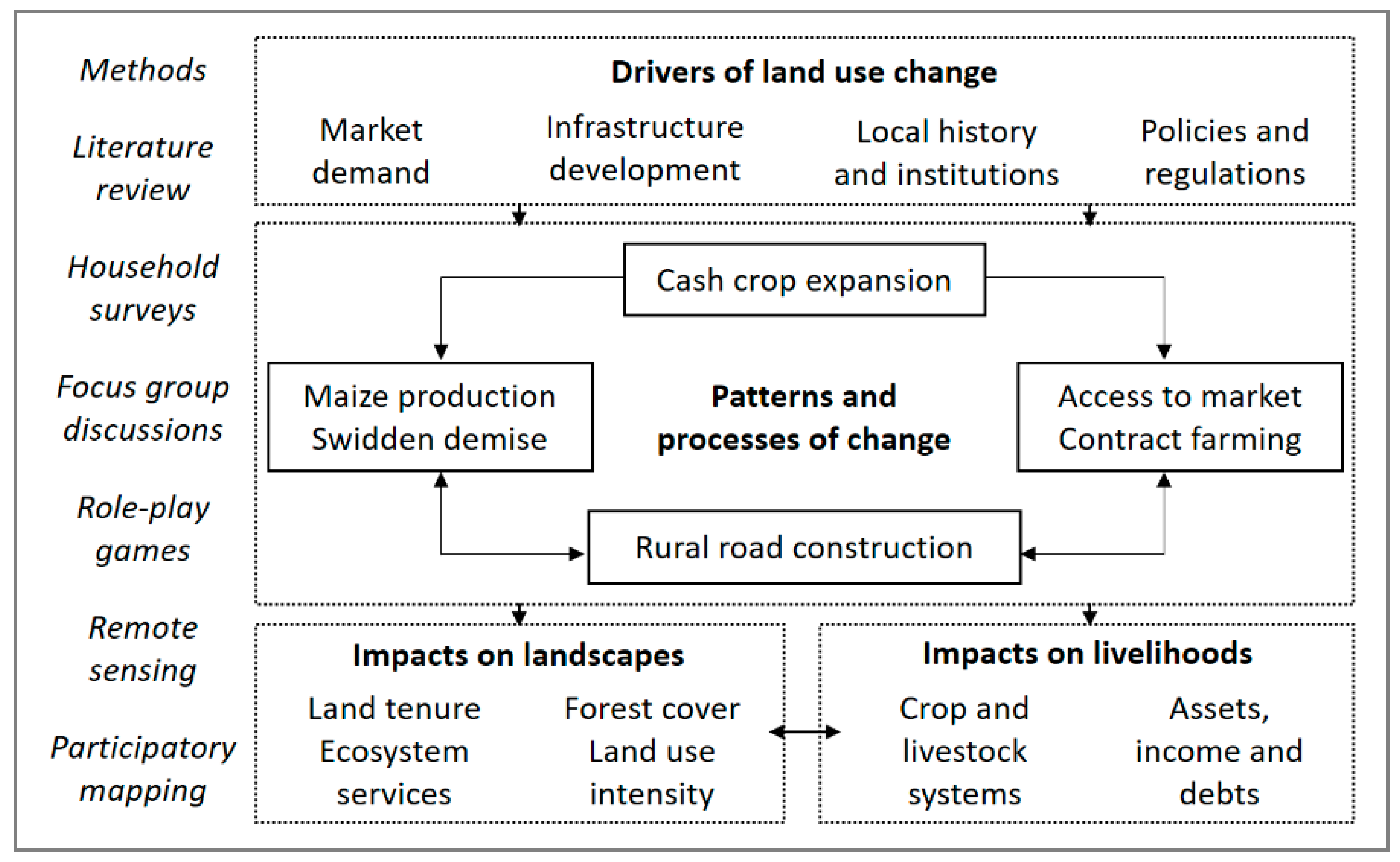
Figure 3.
Forest changes 2003–2015.

Figure 4.
Land-use change in the Natong area, Xiengkhor District, Huaphan Province from 2003 to 2015.
Figure 4.
Land-use change in the Natong area, Xiengkhor District, Huaphan Province from 2003 to 2015.

Figure 5.
Land-use changes in the Natong area from chronological series of remote sensing data.

Figure 6.
Time of equipment purchase by households (HH) in the study area (cumulative values).

Figure 7.
Income composition of the same 73 households surveyed in 2009 and 2016.
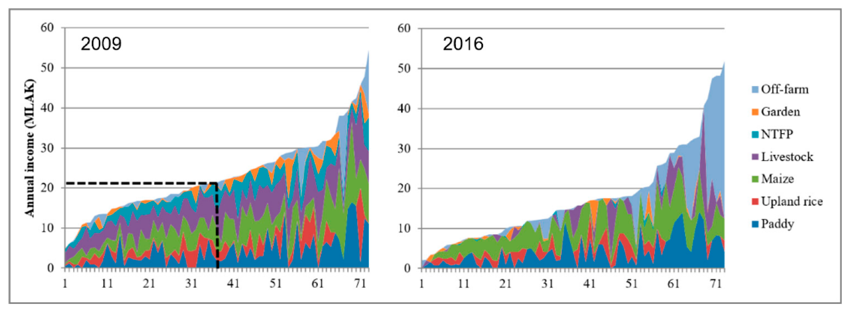
Figure 8.
Change in the three main crops from 2005 to 2015.

Figure 9.
Cumulative length of feeder roads and expansion of maize areas.

Figure 10.
Feeder road expansion.
Publisher’s Note: MDPI stays neutral with regard to jurisdictional claims in published maps and institutional affiliations. |
© 2021 by the authors. Licensee MDPI, Basel, Switzerland. This article is an open access article distributed under the terms and conditions of the Creative Commons Attribution (CC BY) license (http://creativecommons.org/licenses/by/4.0/).
Share and Cite
MDPI and ACS Style
Castella, J.-C.; Phaipasith, S. Rural Roads Are Paving the Way for Land-Use Intensification in the Uplands of Laos. Land 2021, 10, 330. https://doi.org/10.3390/land10030330
AMA Style
Castella J-C, Phaipasith S. Rural Roads Are Paving the Way for Land-Use Intensification in the Uplands of Laos. Land. 2021; 10(3):330. https://doi.org/10.3390/land10030330
Chicago/Turabian StyleCastella, Jean-Christophe, and Sonnasack Phaipasith. 2021. "Rural Roads Are Paving the Way for Land-Use Intensification in the Uplands of Laos" Land 10, no. 3: 330. https://doi.org/10.3390/land10030330
Note that from the first issue of 2016, this journal uses article numbers instead of page numbers. See further details here.