
Relationships between Morphostructural/Geological Framework and Landslide Types: Historical Landslides in the Hilly Piedmont Area of Abruzzo Region (Central Italy)


Abstract
1. Introduction
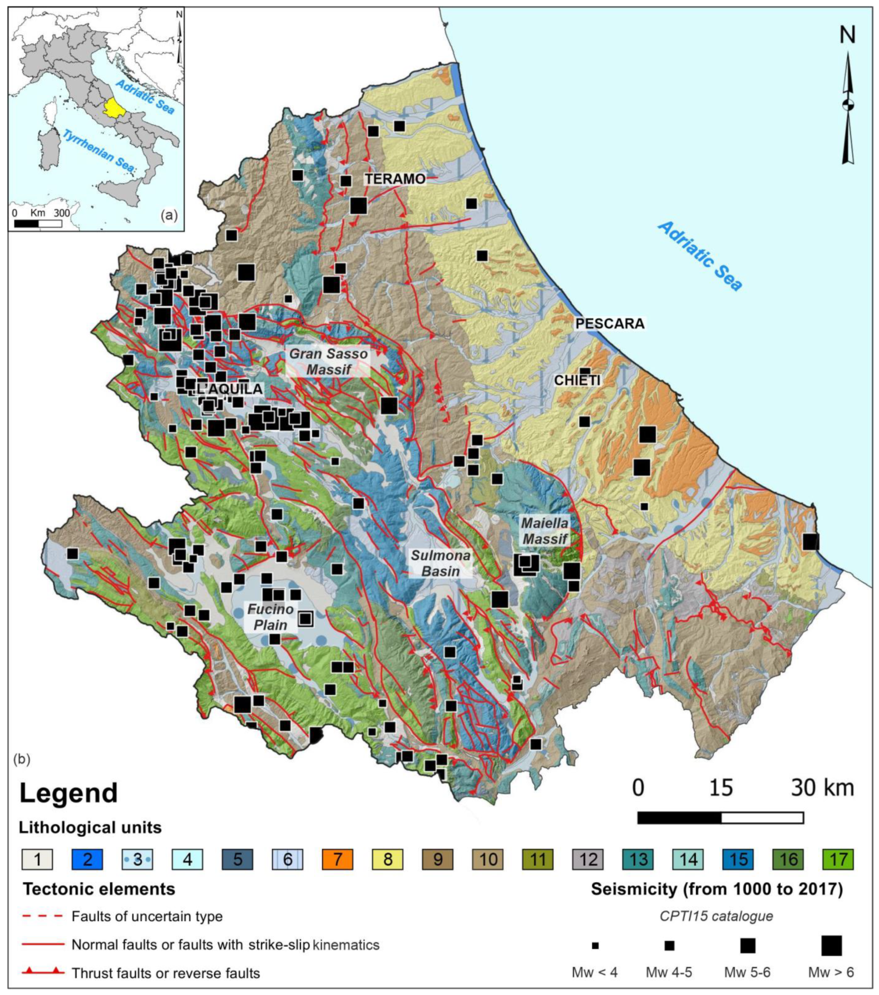
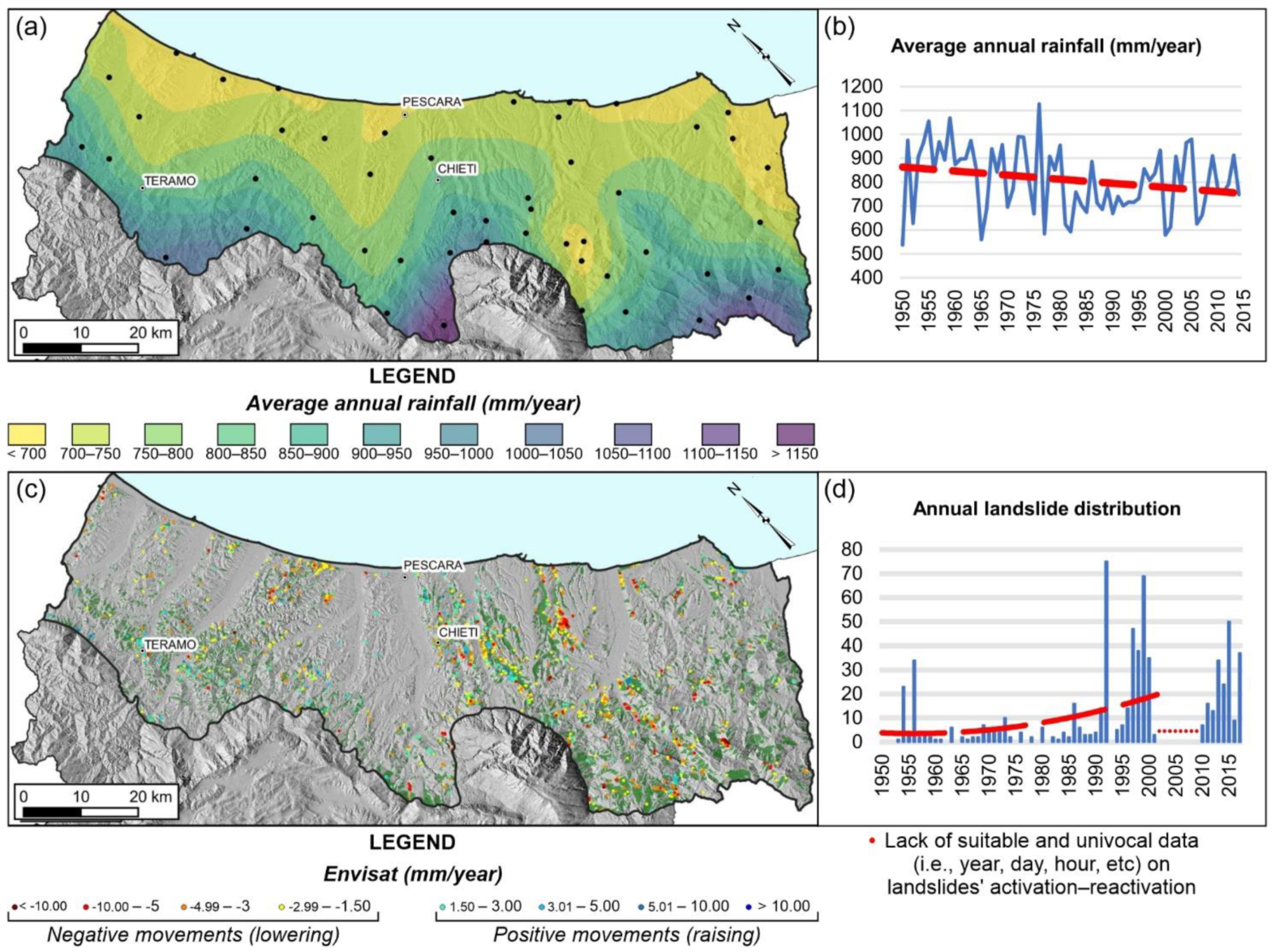
2. Study Area
3. Materials and Methods
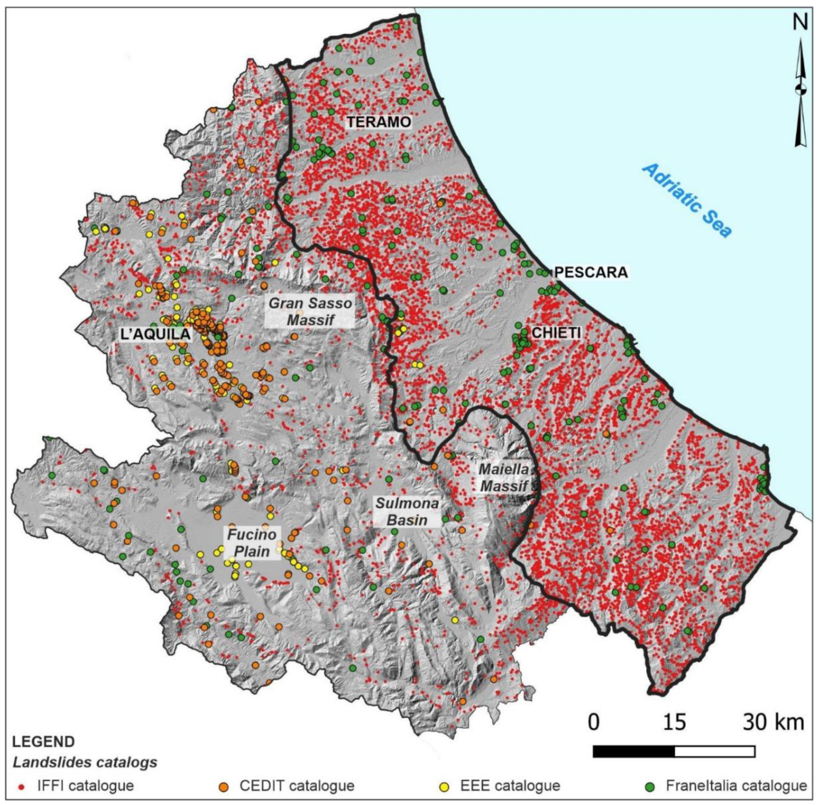
3.1. Landslide Inventory Maps and Database Analysis
3.2. Statistical Analysis of the Relationships between Landslides and Lithological Units
3.3. Detailed Multitemporal and Multidisciplinary Analysis
4. Results
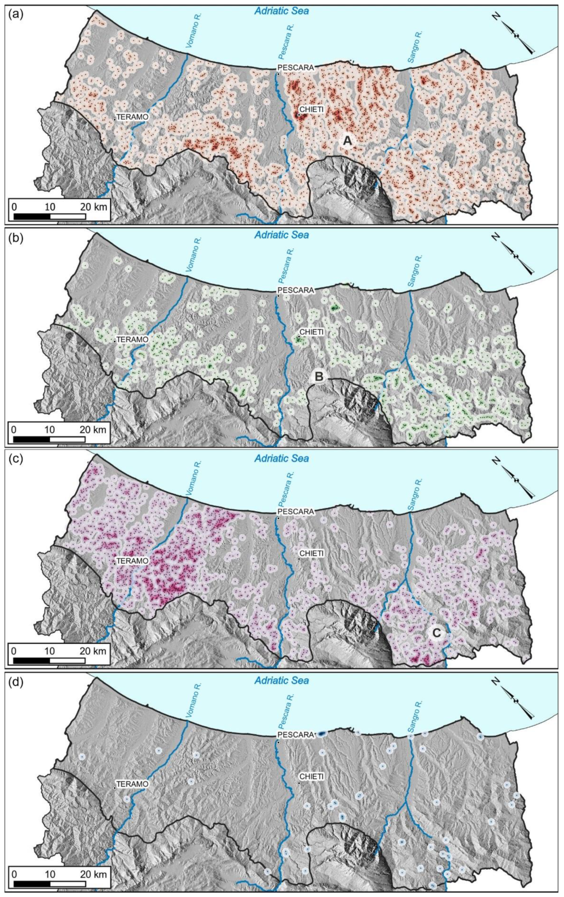
4.1. Density Maps (Heatmaps) of Landslide Types over Abruzzo Hilly Piedmont Area
- (A).
- San Martino sulla Marruccina landslide;
- (B).
- Roccamontepiano landslide;
- (C).
- Montebello sul Sangro landslide.
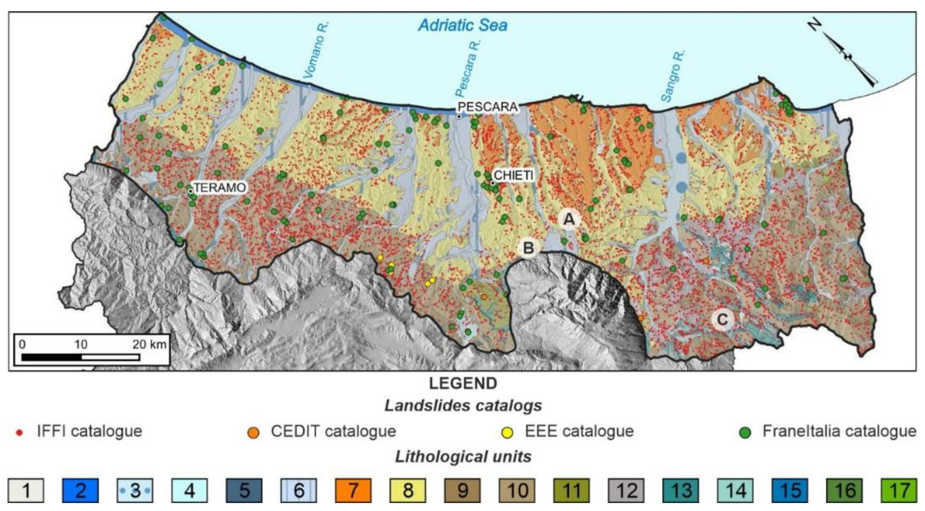
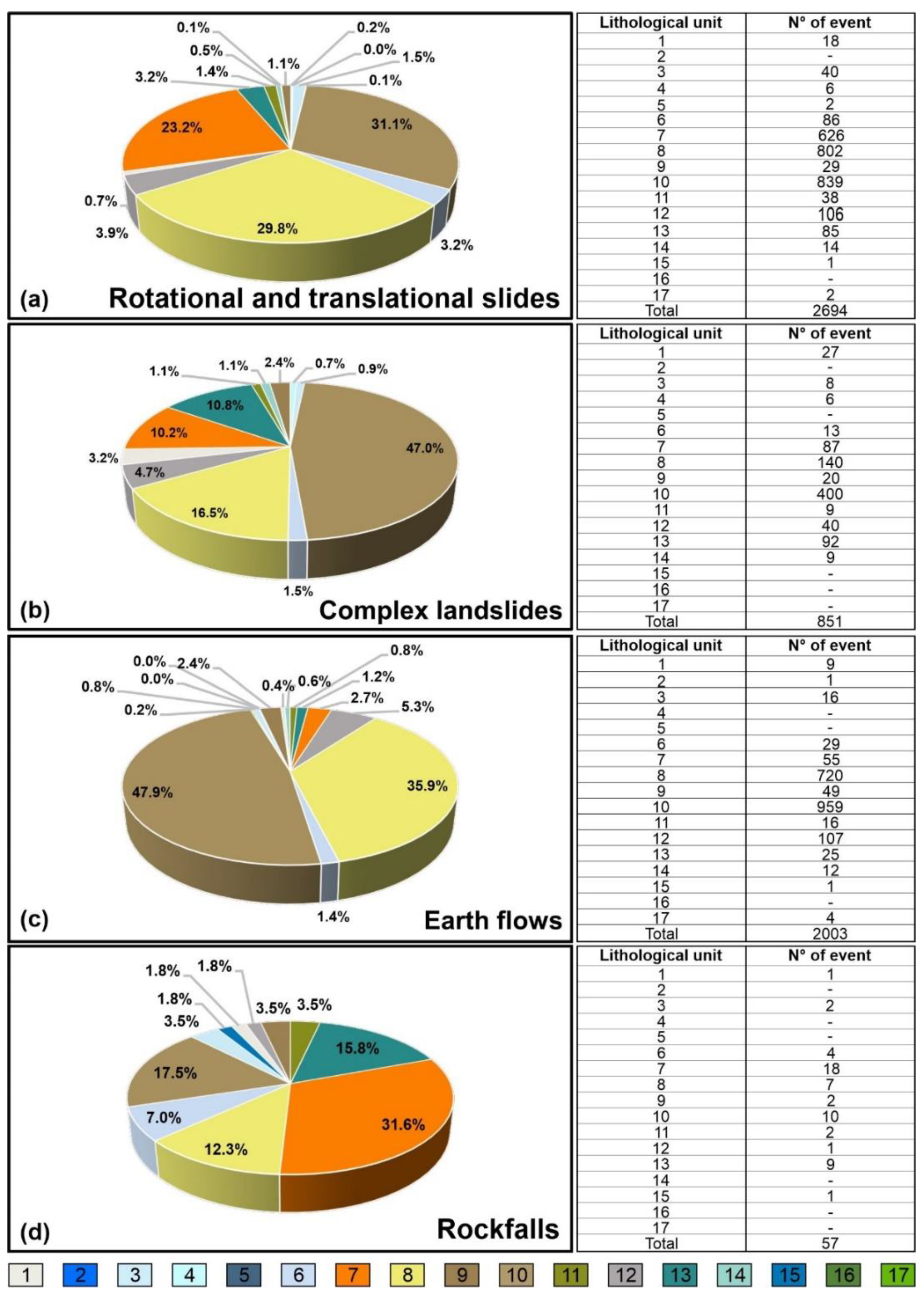
4.2. Relationship between Lithology and Spatial Distribution of Landslide Types
4.3. Selected Landslide Case Studies
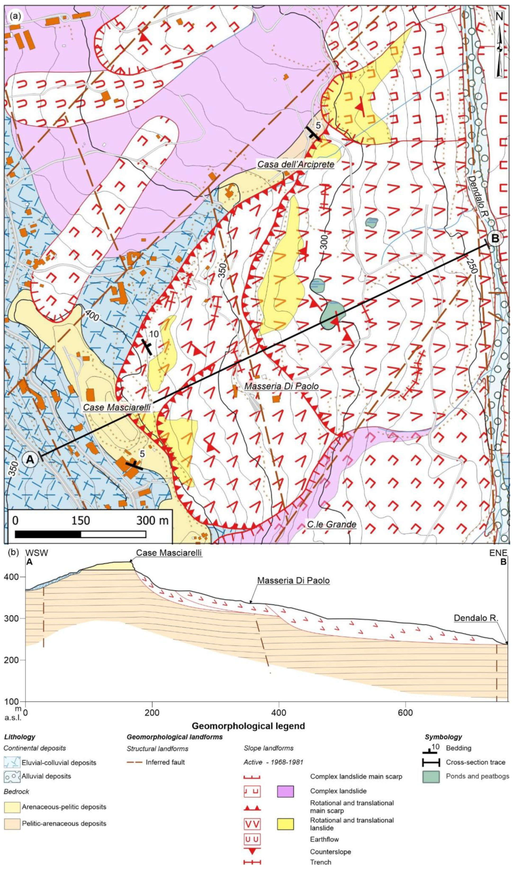
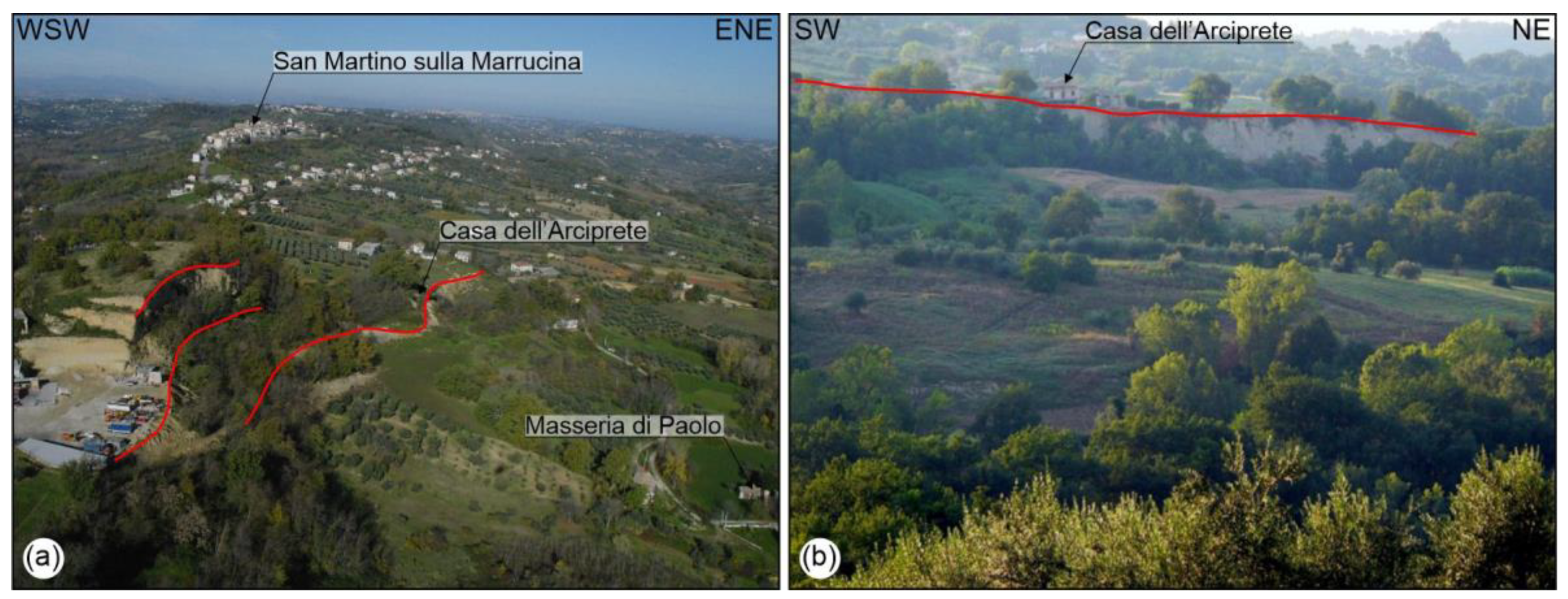
4.3.1. San Martino Sulla Marruccina Landslide
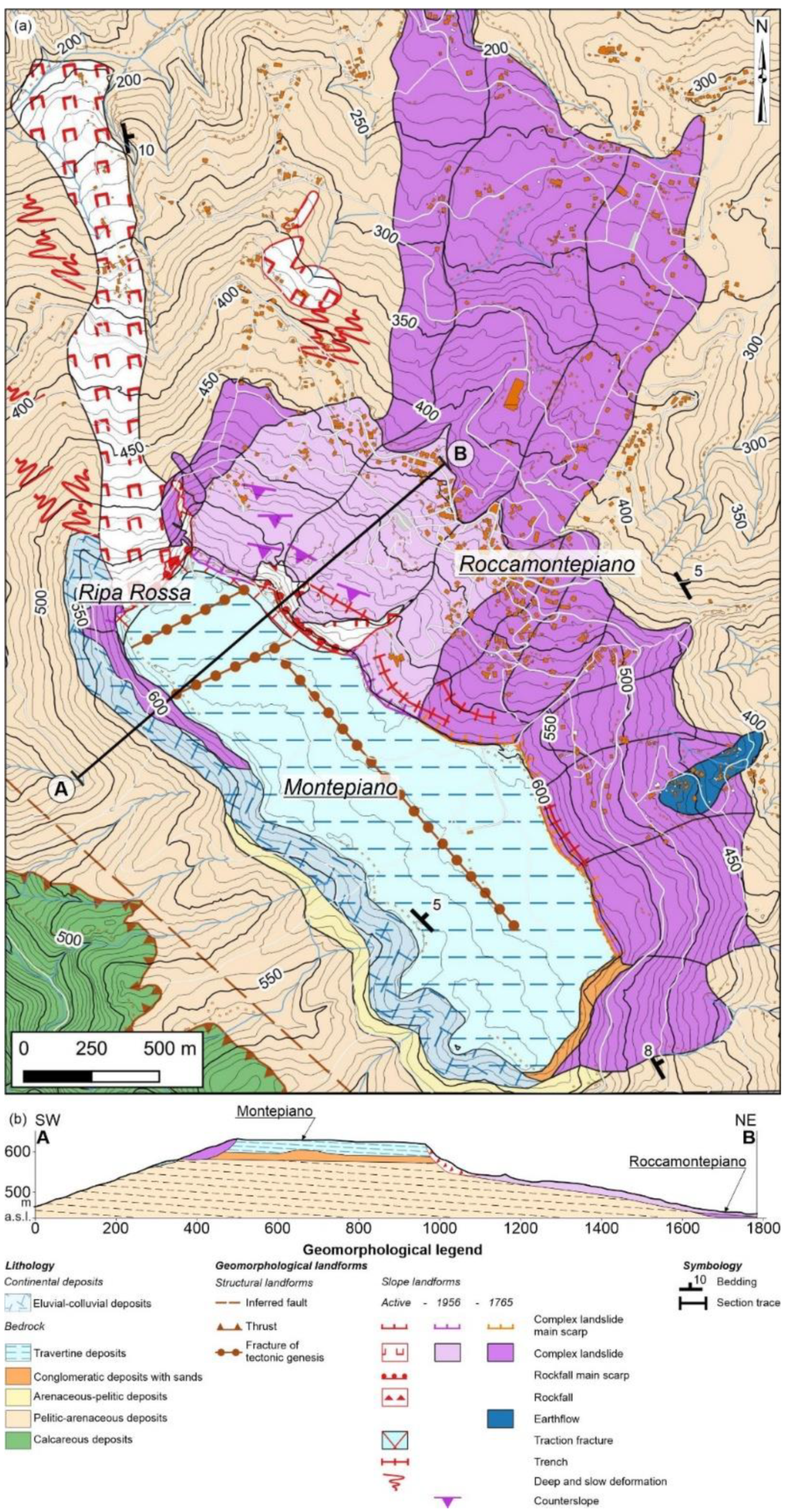
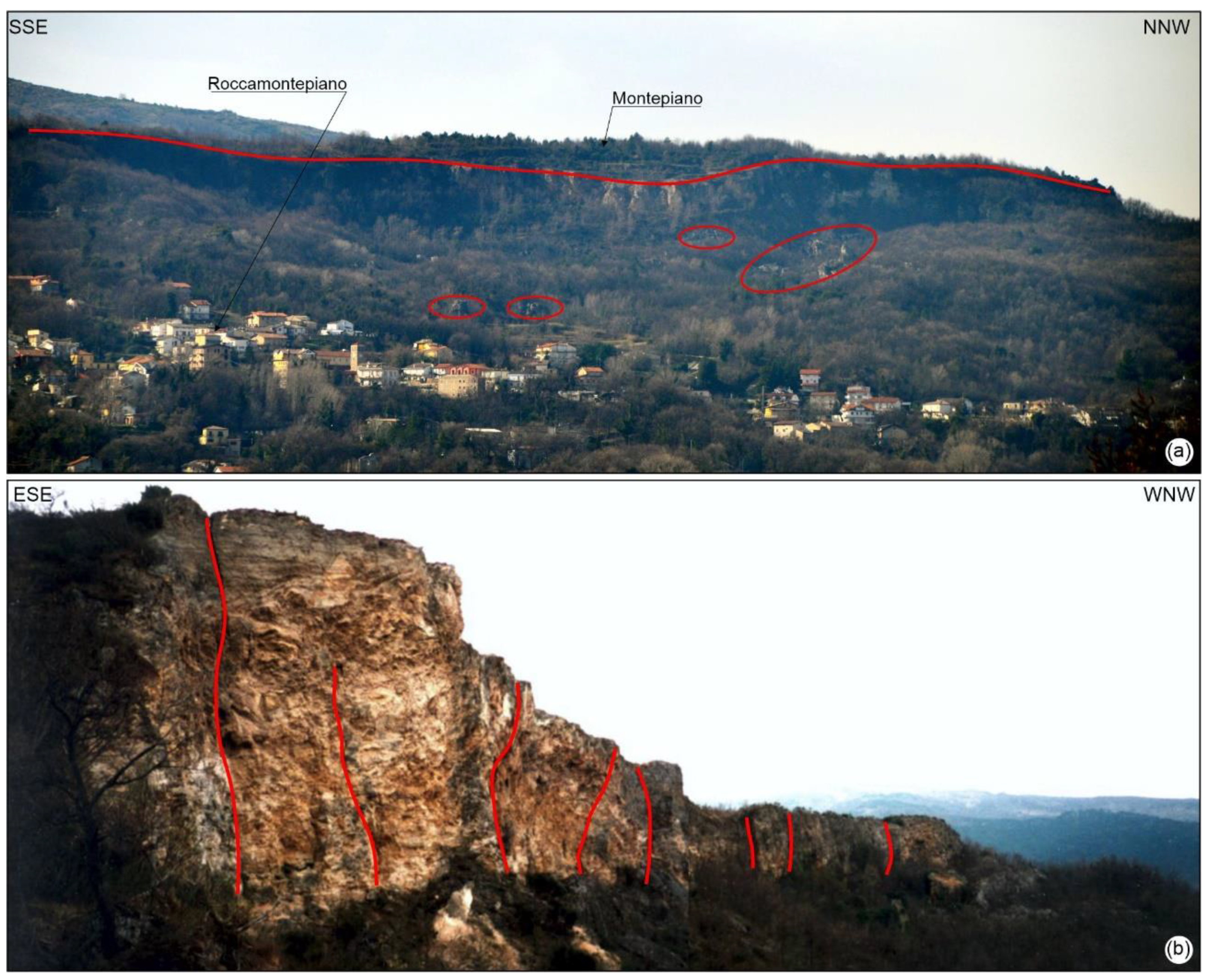
4.3.2. Roccamontepiano Landslide
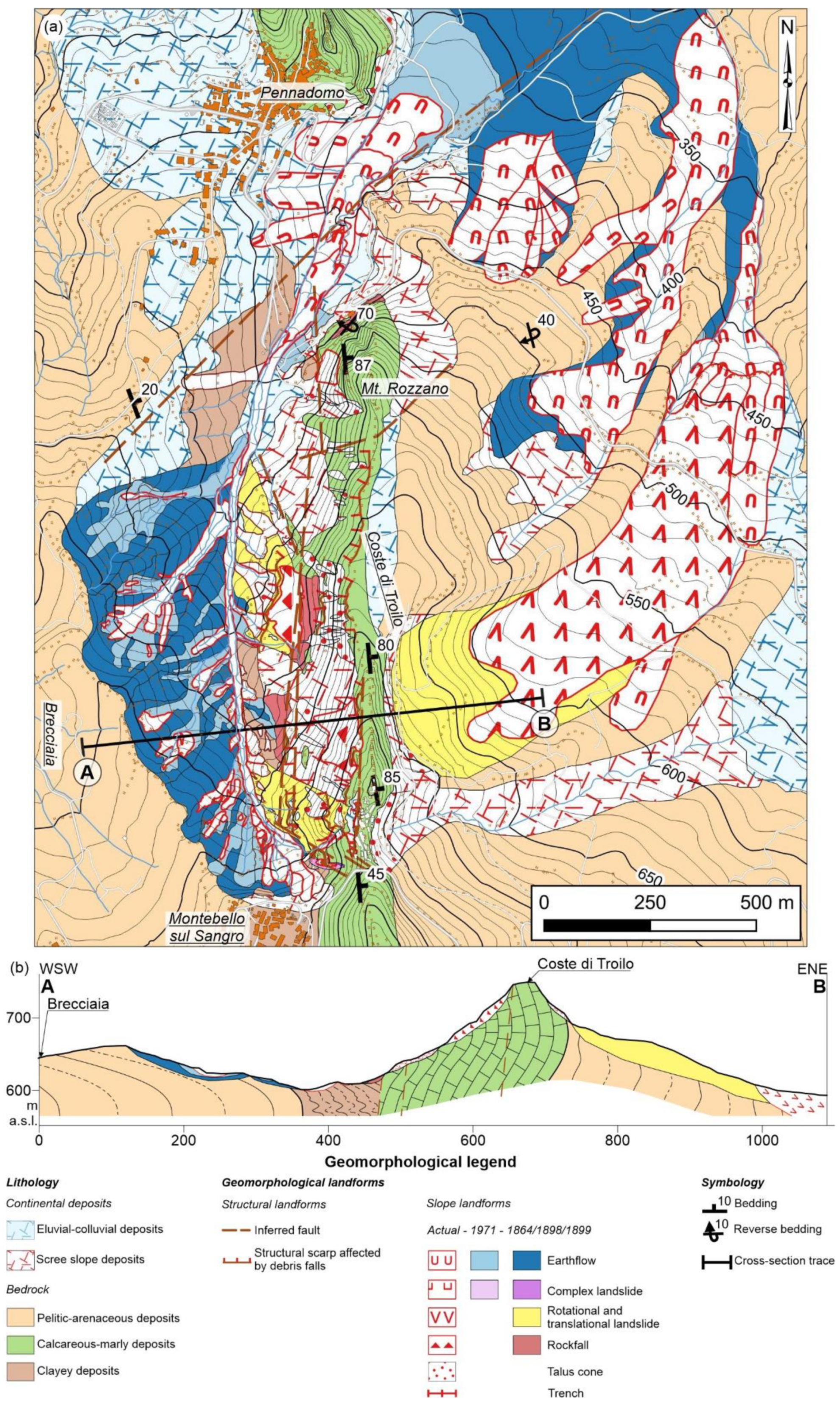
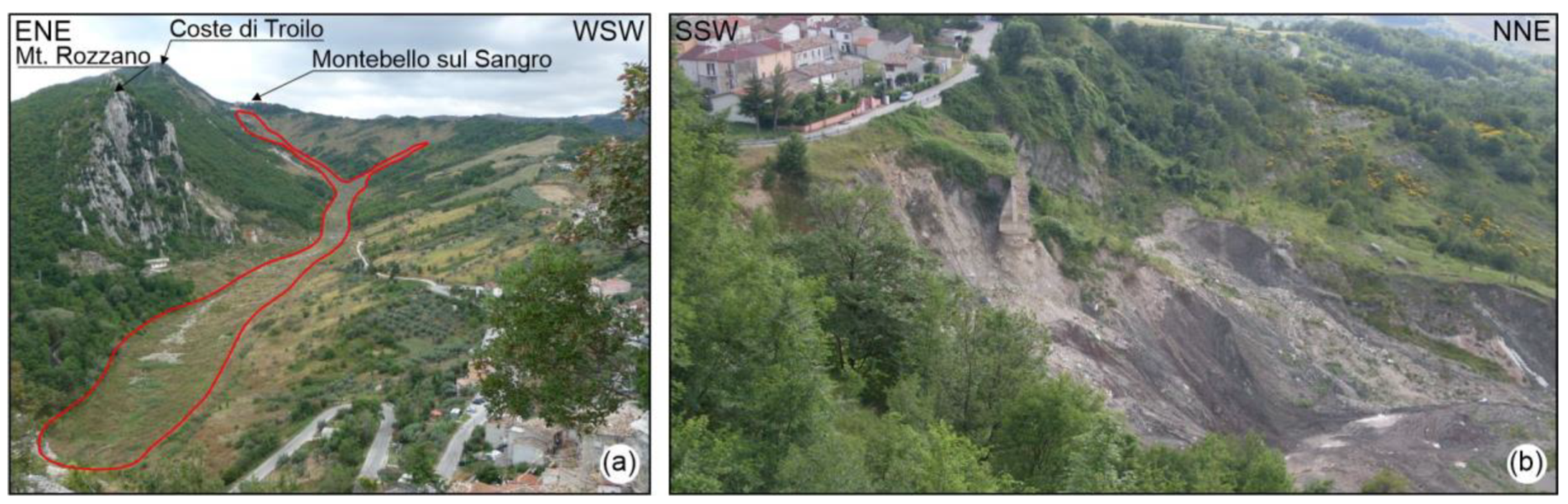
4.3.3. Montebello sul Sangro Landslide
5. Discussion
6. Conclusions
Author Contributions
Funding
Institutional Review Board Statement
Informed Consent Statement
Data Availability Statement
Acknowledgments
Conflicts of Interest
References
- Haque, U.; Blum, P.; da Silva, P.F.; Andersen, P.; Pilz, J.; Chalov, S.R.; Malet, J.P.; Auflič, M.J.; Andres, N.; Poyiadji, E.; et al. Fatal landslides in Europe. Landslides 2016, 13, 1545–1554. [Google Scholar] [CrossRef]
- Marsala, V.; Galli, A.; Paglia, G.; Miccadei, E. Landslide susceptibility assessment of Mauritius Island (Indian ocean). Geosciences 2019, 9, 493. [Google Scholar] [CrossRef]
- Miccadei, E.; Mascioli, F.; Ricci, F.; Piacentini, T. Geomorphology of soft clastic rock coasts in the mid-western Adriatic Sea (Abruzzo, Italy). Geomorphology 2019, 324, 72–94. [Google Scholar] [CrossRef]
- Calista, M.; Menna, V.; Mancinelli, V.; Sciarra, N.; Miccadei, E. Rockfall and Debris Flow Hazard Assessment in the SW Escarpment of Montagna del Morrone Ridge (Abruzzo, Central Italy). Water 2020, 12, 1206. [Google Scholar] [CrossRef]
- Aleotti, P.; Chowdhury, R. Landslide hazard assessment: Summary review and new perspectives. Bull. Eng. Geol. Environ. 1999, 58, 21–44. [Google Scholar] [CrossRef]
- Kjekstad, O.; Highland, L. Economic and social impacts of landslides. In Landslides—Disaster Risk Reduction; Sassa, K., Canuti, P., Eds.; Springer: Berlin/Heidelberg, Germany; Tokyo, Japan, 2009; pp. 573–587. [Google Scholar] [CrossRef]
- Petley, D. Global patterns of loss of life from landslides. Geology 2012, 40, 927–930. [Google Scholar] [CrossRef]
- Rossi, M.; Guzzetti, F.; Salvati, P.; Donnini, M.; Napolitano, E.; Bianchi, C. A predictive model of societal landslide risk in Italy. Earth-Sci. Rev. 2019, 196, 102849. [Google Scholar] [CrossRef]
- Segoni, S.; Piciullo, L.; Gariano, S.L. A review of the recent literature on rainfall thresholds for landslide occurrence. Landslides 2018, 15, 1483–1501. [Google Scholar] [CrossRef]
- Carabella, C.; Miccadei, E.; Paglia, G.; Sciarra, N. Post-Wildfire Landslide Hazard Assessment: The Case of The 2017 Montagna Del Morrone Fire (Central Apennines, Italy). Geosciences 2019, 9, 175. [Google Scholar] [CrossRef]
- Farabollini, P.; De Pari, P.; Discenza, M.E.; Minnillo, M.; Carabella, C.; Paglia, G.; Miccadei, E. Geomorphological evidence of debris flows and landslides in the Pescara del Tronto area (Sibillini Mts, Marche Region, Central Italy). J. Maps 2020. [Google Scholar] [CrossRef]
- Piacentini, T.; Calista, M.; Crescenti, U.; Miccadei, E.; Sciarra, N. Seismically induced snow avalanches: The central Italy case. Front. Earth Sci. 2020, 8, 1–27. [Google Scholar] [CrossRef]
- Piacentini, T.; Miccadei, E.; Di Michele, R.; Sciarra, N.; Mataloni, G. Geomorphological analysis applied to rock falls in Italy: The case of the san venanzio gorges (Aterno river, Abruzzo, Italy). Ital. J. Eng. Geol. Environ. 2013, 6, 467–479. [Google Scholar]
- D’Alessandro, L.; Miccadei, E.; Piacentini, T. Morphostructural elements of central-eastern Abruzzi: Contributions to the study of the role of tectonics on the morphogenesis of the Apennine chain. Quat. Int. 2003, 101–102, 115–124. [Google Scholar] [CrossRef]
- Kumar, V.; Gupta, V.; Sundriyal, Y.P. Spatial interrelationship of landslides, litho-tectonics, and climate regime, Satluj valley, Northwest Himalaya. Geol. J. 2019, 54, 537–551. [Google Scholar] [CrossRef]
- Zhou, C.H.; Lee, C.F.; Li, J.; Xu, Z.W. On the spatial relationship between landslides and causative factors on Lantau Island, Hong Kong. Geomorphology 2002, 43, 197–207. [Google Scholar] [CrossRef]
- Safaei, M.; Omar, H.; Huat, B.K.; Yousof, Z.B.M. Relationship between lithology factor and landslide occurrence based on information value (IV) and frequency ratio (FR) approaches—Case study in north of Iran. Electron. J. Geotech. Eng. 2012, 17, 79–90. [Google Scholar]
- Guzzetti, F.; Cardinali, M.; Reichenbach, P. The influence of structural setting and lithology on landslide type and pattern. Environ. Eng. Geosci. 1996, 2, 531–555. [Google Scholar] [CrossRef]
- Marchesini, I.; Santangelo, M.; Guzzetti, F.; Cardinali, M.; Bucci, F. Assessing the influence of morpho-structural setting on landslide abundance. Georisk 2015, 9, 261–271. [Google Scholar] [CrossRef]
- Benzougagh, B.; Meshram, S.G.; Baamar, B.; Dridri, A.; Boudad, L.; Sadkaoui, D.; Mimich, K. Relationship between landslide and morpho-structural analysis: A case study in Northeast of Morocco. Appl. Water Sci. 2020, 10, 175. [Google Scholar] [CrossRef]
- D’Amato Avanzi, G.; Giannecchini, R.; Puccinelli, A. The influence of the geological and geomorphological settings on shallow landslides. An example in a temperate climate environment: The 19 June 1996 event in northwestern Tuscany (Italy). Eng. Geol. 2004, 73, 215–228. [Google Scholar] [CrossRef]
- Wang, G.; Chen, X.; Chen, W. Spatial prediction of landslide susceptibility based on GIS and discriminant functions. ISPRS Int. J. Geo-Inf. 2020, 9, 144. [Google Scholar] [CrossRef]
- Fell, R.; Whitt, G.; Miner, T.; Flentje, P. Guidelines for landslide susceptibility, hazard and risk zoning for land use planning. Eng. Geol. 2008, 102, 83–84. [Google Scholar] [CrossRef]
- Gariano, S.L.; Guzzetti, F. Landslides in a changing climate. Earth-Sci. Rev. 2016, 162, 227–252. [Google Scholar] [CrossRef]
- Alvioli, M.; Melillo, M.; Guzzetti, F.; Rossi, M.; Palazzi, E.; von Hardenberg, J.; Brunetti, M.T.; Peruccacci, S. Implications of climate change on landslide hazard in Central Italy. Sci. Total Environ. 2018, 630, 1528–1543. [Google Scholar] [CrossRef]
- Coe, J.A.; Godt, J.W. Review of approaches for assessing the impact of climate change on landslide hazards. In Landslides and Engineered Slopes: Protecting Society through Improved Understanding, Proceedings of the 11th International and 2nd North American Symposium on Landslides and Engineered Slopes, Banff, AB, Canada, 3–8 June 2012; Eberhardt, E., Froese, C., Turner, A.K., Leroueil, S., Eds.; Taylor & Francis Group: London, UK, 2012; pp. 371–377. ISBN 9780415621236. [Google Scholar]
- Ciervo, F.; Rianna, G.; Mercogliano, P.; Papa, M.N. Effects of climate change on shallow landslides in a small coastal catchment in southern Italy. Landslides 2017, 14, 1043–1055. [Google Scholar] [CrossRef]
- Canuti, P.; Casagli, N.; Ermini, L.; Fanti, R.; Farina, P. Landslide activity as a geoindicator in Italy: Significance and new perspectives from remote sensing. Environ. Geol. 2004, 45, 907–919. [Google Scholar] [CrossRef]
- Guzzetti, F. Landslide fatalities and the evaluation of landslide risk in Italy. Eng. Geol. 2000, 58, 89–107. [Google Scholar] [CrossRef]
- Melis, M.T.; Pelo, S.D.; Erbì, I.; Loche, M.; Deiana, G.; Demurtas, V.; Meloni, M.A.; Dessì, F.; Funedda, A.; Scaioni, M.; et al. Thermal remote sensing from UAVs: A review on methods in coastal cliffs prone to landslides. Remote Sens. 2020, 12, 1971. [Google Scholar] [CrossRef]
- Lundmark, A.M.; Augland, L.E.; Jørgensen, S.V. Digital fieldwork with Fieldmove—How do digital tools influence geoscience students’ learning experience in the field? J. Geogr. High. Educ. 2020, 44, 427–440. [Google Scholar] [CrossRef]
- Reddy, G.P.O. Remote Sensing and GIS for Geomorphological Mapping. In Geospatial Technologies in Land Resources Mapping, Monitoring and Management; Reddy, G., Singh, S., Eds.; Spinger: Cham, Switzerland, 2018; pp. 223–252. [Google Scholar] [CrossRef]
- Melelli, L.; Gregori, L.; Mancinelli, L. The Use of Remote Sensed Data and GIS to Produce a Digital Geomorphological Map of a Test Area in Central Italy. In Remote Sensing of Planet Earth; Chemin, Y., Ed.; InTech: London, UK, 2012; pp. 97–116. [Google Scholar] [CrossRef]
- Jaboyedoff, M.; Oppikofer, T.; Abellán, A.; Derron, M.H.; Loye, A.; Metzger, R.; Pedrazzini, A. Use of LIDAR in landslide investigations: A review. Nat. Hazards 2012, 61, 5–28. [Google Scholar] [CrossRef]
- Antonielli, B.; Mazzanti, P.; Rocca, A.; Bozzano, F.; Cas, L.D. A-DInSAR performance for updating landslide inventory in mountain areas: An example from lombardy region (Italy). Geosciences 2019, 9, 364. [Google Scholar] [CrossRef]
- Herrera, G.; Mateos, R.M.; García-Davalillo, J.C.; Grandjean, G.; Poyiadji, E.; Maftei, R.; Filipciuc, T.C.; Jemec Auflič, M.; Jež, J.; Podolszki, L.; et al. Landslide databases in the Geological Surveys of Europe. Landslides 2018, 15, 359–379. [Google Scholar] [CrossRef]
- Trigila, A.; Iadanza, C.; Bussettini, M.; Lastoria, B. Dissesto Idrogeologico in Italia: Pericolosità e Indicatori di Rischio—Edizione 2018; ISPRA: Rome, Italy, 2018; ISBN 9788844809010. [Google Scholar]
- Parotto, M.; Cavinato, G.P.; Miccadei, E.; Tozzi, M. Line CROP 11: Central Apennines. In CROP Atlas: Seismic Reflection Profiles of the Italian Crust; Scrocca, D., Doglioni, C., Innocenti, F., Manetti, P., Mazzotti, A., Bertelli, L., Burbi, L., D’Offizi, S., Eds.; Memorie Descrittive della Carta Geologica d’Italia: Rome, Italy, 2004; pp. 145–153. [Google Scholar]
- Miccadei, E.; Carabella, C.; Paglia, G.; Piacentini, T. Paleo-drainage network, morphotectonics, and fluvial terraces: Clues from the verde stream in the middle Sangro river (central italy). Geosciences 2018, 8, 337. [Google Scholar] [CrossRef]
- Miccadei, E.; Piacentini, T.; Buccolini, M. Long-term geomorphological evolution in the Abruzzo area, Central Italy: Twenty years of research. Geol. Carpathica 2017, 68, 19–28. [Google Scholar] [CrossRef]
- Ascione, A.; Cinque, A.; Miccadei, E.; Villani, F.; Berti, C. The Plio-Quaternary uplift of the Apennine chain: New data from the analysis of topography and river valleys in Central Italy. Geomorphology 2008, 102, 105–118. [Google Scholar] [CrossRef]
- Ori, G.; Serafini, G.; Visentin, C.; Ricci Lucchi, F.; Casnedi, R.; Colalongo, M.L.; Mosna, S. The Pliocene-Pleistocene Adriatic foredeep (Marche and Abruzzo, Italy): An integrated approach to surface and subsurface geology. In Proceedings of the 3rd EAPG Conference, Adriatic Foredeep Field Trip Guide Book, Firenze, Italy, 26–30 May 1991; p. 85. [Google Scholar]
- Carabella, C.; Buccolini, M.; Galli, L.; Miccadei, E.; Paglia, G.; Piacentini, T. Geomorphological analysis of drainage changes in the NE Apennines piedmont area: The case of the middle Tavo River bend (Abruzzo, Central Italy). J. Maps 2020, 16, 222–235. [Google Scholar] [CrossRef]
- Bigi, S.; Cantalamessa, G.; Centamore, E.; Didaskalou, P.; Dramis, F.; Farabollini, P.; Gentili, B.; Invernizzi, C.; Micarelli, A.; Nisio, S.; et al. La fascia periadriatica marchigiano-abruzzese dal pliocene medio ai tempi attuale: Evoluzione tettonico-sedimentaria e geomorfologica. Stud. Geol. Camerti 1995, 37–49. [Google Scholar] [CrossRef]
- Parlagreco, L.; Mascioli, F.; Miccadei, E.; Antonioli, F.; Gianolla, D.; Devoti, S.; Leoni, G.; Silenzi, S. New data on Holocene relative sea level along the Abruzzo coast (central Adriatic, Italy). Quat. Int. 2011, 232, 179–186. [Google Scholar] [CrossRef]
- Carabella, C.; Boccabella, F.; Buccolini, M.; Ferrante, S.; Pacione, A.; Gregori, C.; Pagliani, T.; Piacentini, T.; Miccadei, E. Geomorphology of landslide–flood-critical areas in hilly catchments and urban areas for EWS (Feltrino Stream and Lanciano town, Abruzzo, Central Italy). J. Maps 2020. [Google Scholar] [CrossRef]
- Piacentini, T.; Galli, A.; Marsala, V.; Miccadei, E. Analysis of soil erosion induced by heavy rainfall: A case study from the NE Abruzzo Hills Area in Central Italy. Water 2018, 10, 1314. [Google Scholar] [CrossRef]
- Miccadei, E.; Piacentini, T.; Daverio, F.; Di Michele, R. Geomorphological Instability Triggered by Heavy Rainfall: Examples in the Abruzzi Region (Central Italy). In Studies on Environmental and Applied Geomorphology; Piacentini, T., Miccadei, E., Eds.; InTech: London, UK, 2012; pp. 45–62. [Google Scholar] [CrossRef]
- Rovida, A.; Locati, M.; Camassi, R.; Lolli, B.; Gasperini, P.; Antonucci, A. The Italian Earthquake Catalogue CPTI15—Version 3.0; Istituto Nazionale di Geofisica e Vulcanologia (INGV): Rome, Italy, 2021. [Google Scholar] [CrossRef]
- ISIDe Working Group. Italian Seismological Instrumental and Parametric Database (ISIDe); Istituto Nazionale di Geofisica e Vulcanologia (INGV): Rome, Italy, 2007. [Google Scholar] [CrossRef]
- Fazzini, M.; Giuffrida, A. Une nouvelle proposition quantitative des régimes pluviométriques dans le territoire de Italie: Premiers résultats. In Proceedings of the Climat Urbain, Ville et Architecture—Actes XVIII Colloque Internationale de Climatologie, Genova, Italy, 7–11 September 2005; pp. 361–364. [Google Scholar]
- Peel, M.C.; Finlayson, B.L.; McMahon, T.A. Updated world map of the Köppen-Geiger climate classification. Spatial Data Access Tool (SDAT)OGC Standards-based Geospatial Data Visualization/Download. Hydrol. Earth Syst. 2007, 11, 1633–1644. [Google Scholar] [CrossRef]
- Di Lena, B.; Antenucci, F.; Mariani, L. Space and time evolution of the Abruzzo precipitation. Ital. J. Agrometeorol. 2012, 1, 5–20. [Google Scholar]
- Mariani, L.; Parisi, S.G. Extreme rainfalls in the mediterranean area. In Storminess and Environmental Change; Diodato, N., Bellocchi, G., Eds.; Springer: London, UK, 2014; pp. 17–37. [Google Scholar] [CrossRef]
- Scorzini, A.R.; Leopardi, M. Precipitation and temperature trends over central Italy (Abruzzo Region): 1951–2012. Theor. Appl. Climatol. 2019, 135, 959–977. [Google Scholar] [CrossRef]
- Accordi, B.; Carbone, F. Carta delle litofacies del Lazio-Abruzzi ed aree limitrofe. CNR—Progetto Finalizzato “Geodinamica”: Rome, Italy. Quad. Ric. Sci. 1988, 114, 223. [Google Scholar]
- Vezzani, L.; Ghisetti, F. Carta Geologica Dell’Abruzzo—Scala 1:100,000; SELCA: Firenze, Italy, 1998. [Google Scholar]
- Guzzetti, F.; Mondini, A.C.; Cardinali, M.; Fiorucci, F.; Santangelo, M.; Chang, K.T. Landslide inventory maps: New tools for an old problem. Earth-Sci. Rev. 2012, 112, 42–66. [Google Scholar] [CrossRef]
- Trigila, A.; Iadanza, C.; Spizzichino, D. Quality assessment of the Italian Landslide Inventory using GIS processing. Landslides 2010, 7, 455–470. [Google Scholar] [CrossRef]
- ISPRA. Progetto IFFI (Inventario dei Fenomeni Franosi in Italia) Dipartimento Difesa del Suolo-Servizio Geologico d’Italia–Regione Abruzzo. 2007. Available online: https://idrogeo.isprambiente.it/app/iffi?@=41.55172525894153,12.57350148381829,1 (accessed on 24 October 2020).
- Fortunato, C.; Martino, S.; Prestininzi, A.; Romeo, R.W. New release of the italia catalogue of earthquake-induced ground failures (CEDIT). Ital. J. Eng. Geol. Environ. 2012, 2, 63–74. [Google Scholar] [CrossRef]
- Martino, S.; Bozzano, F.; Caporossi, P.; D’Angiò, D.; Della Seta, M.; Esposito, C.; Fantini, A.; Fiorucci, M.; Giannini, L.M.; Iannucci, R.; et al. Impact of landslides on transportation routes during the 2016–2017 Central Italy seismic sequence. Landslides 2019, 16, 1221–1241. [Google Scholar] [CrossRef]
- Martino, S.; Bozzano, F.; Caporossi, P.; D’Angiò, D.; Della Seta, M.; Esposito, C.; Fantini, A.; Fiorucci, M.; Giannini, L.M.; Iannucci, R.; et al. Ground Effects triggered by the 24 August 2016, Mw 6.0 Amatrice (Italy) earthquake: Surveys and inventorying to update the cebit catalogue. Geogr. Fis. Din. Quat. 2017, 40, 77–95. [Google Scholar] [CrossRef]
- Guerrieri, L. Earthquake Environmental Effect for seismic hazard assessment: The ESI intensity scale and the EEE Catalogue. Mem. Descr. Della Cart. Geol. Italia 2015, 97, 181. [Google Scholar]
- Calvello, M.; Pecoraro, G. FraneItalia: A catalog of recent Italian landslides. Geoenviron. Disasters 2018, 5, 16. [Google Scholar] [CrossRef]
- Peruccacci, S.; Brunetti, M.T.; Luciani, S.; Vennari, C.; Guzzetti, F. Lithological and seasonal control on rainfall thresholds for the possible initiation of landslides in central Italy. Geomorphology 2012, 139–140, 79–90. [Google Scholar] [CrossRef]
- Henriques, C.; Zêzere, J.L.; Marques, F. The role of the lithological setting on the landslide pattern and distribution. Eng. Geol. 2015, 189, 17–31. [Google Scholar] [CrossRef]
- Smith, M.J.; Paron, P.; Griffiths, J. Geomorphological Mapping, Methods and Applications; Elsevier Science: Oxford, UK, 2011; ISBN 9780444534460. [Google Scholar]
- ISPRA. AIGEO Aggiornamento ed Integrazione delle Linee Guida della Carta Geomorfologica D’italia in Scala 1:50,000. In Quaderni Serie III; Servizio Geologico d’Italia: Rome, Italy, 2018. [Google Scholar]
- Gustavsson, M.; Kolstrup, E.; Seijmonsbergen, A.C. A new symbol-and-GIS based detailed geomorphological mapping system: Renewal of a scientific discipline for understanding landscape development. Geomorphology 2006, 77, 90–111. [Google Scholar] [CrossRef]
- Seijmonsbergen, A.C. The Modern Geomorphological Map. In Treatise on Geomorphology; Elsevier: Amsterdam, The Netherlands, 2013; pp. 35–52. [Google Scholar] [CrossRef]
- D’Alessandro, L.; De Pippo, T.; Donadio, C.; Mazzarella, A.; Miccadei, E. Fractal dimension in Italy: A geomorphological key to interpretation. Z. Geomorphol. 2006, 50, 479–499. [Google Scholar] [CrossRef]
- Pasculli, A.; Palermi, S.; Sarra, A.; Piacentini, T.; Miccadei, E. A modelling methodology for the analysis of radon potential based on environmental geology and geographically weighted regression. Environ. Model. Softw. 2014, 54, 165–181. [Google Scholar] [CrossRef]
- Crosetto, M.; Monserrat, O.; Cuevas-González, M.; Devanthéry, N.; Crippa, B. Persistent Scatterer Interferometry: A review. ISPRS J. Photogramm. Remote Sens. 2016, 115, 78–89. [Google Scholar] [CrossRef]
- Bozzano, F.; Mazzanti, P.; Perissin, D.; Rocca, A.; De Pari, P. Basin scale assessment of landslides geomorphological setting by advanced InSAR analysis. Remote Sens. 2017, 9, 267. [Google Scholar] [CrossRef]
- Miccadei, E.; Paron, P.; Piacentini, T. The SW escarpment of Montagna del Morrone (Abruzzi, Central Italy): Geomorphology of a fault-generated mountain front. Geogr. Fis. Din. Quat. 2004, 27, 55–87. [Google Scholar]
- Calista, M.; Mascioli, F.; Menna, V.; Miccadei, E.; Piacentini, T. Recent geomorphological evolution and 3d numerical modelling of soft clastic rock cliffs in the mid-western Adriatic Sea (Abruzzo, Italy). Geosciences 2019, 9, 309. [Google Scholar] [CrossRef]
- ISPRA. Geological Map of Italy, Scale 1:50,000, Sheet 361 “Chieti”. Available online: http://www.isprambiente.gov.it/Media/carg/361_CHIETI/Foglio.html (accessed on 22 September 2020).
- Bozzano, F.; Carabella, C.; De Pari, P.; Discenza, M.E.; Fantucci, R.; Mazzanti, P.; Miccadei, E.; Rocca, A.; Romano, S.; Sciarra, N. Geological and geomorphological analysis of a complex landslides system: The case of San Martino sulla Marruccina (Abruzzo, Central Italy). J. Maps 2020, 16, 126–136. [Google Scholar] [CrossRef]
- Buccolini, M.; D’Alessandro, L.; Miccadei, E.; Sciarra, N. Susceptibility assessment of an area subject to a large landslide: The case of San Martino sulla Marrucina (Chieti province—Central Italy). In Proceedings of the IV international conference on computer simulation in risk analysis and hazard mitigation, Rome, Italy, 28–30 September 2021; WIT Press: Southampton, UK, 2004; pp. 245–255, ISSN 14706326. [Google Scholar]
- Damiano, E.; Giordan, D.; Allasia, P.; Baldo, M.; Sciarra, N.; Lollino, G. Multitemporal study of the San Martino sulla Marrucina landslide (Central Italy). In Landslide Science and Practice: Early Warning, Instrumentation and Monitoring; Margottini, C., Canuti, P., Sassa, K., Eds.; Springer: Berlin, Germany, 2013; pp. 257–263. [Google Scholar] [CrossRef]
- Crescenti, U.; D’Alessandro, L.; Genevois, R. La Ripa di Montepiano (Abruzzo): Un primo esame delle caratteristiche geomorfologiche in rapporto alla stabilità. Mem. Della Soc. Geol. Ital. 1987, 37, 775–787. [Google Scholar]
- D’Alessandro, L.; Genevois, R.; Berti, M.; Urbani, A.; Tecca, P.R. Geomorphology, stability analises and stabilization works on the Montepiano travertinous cliff (Central Italy). In Applied Geomorphology: Theory and Practice; Allison, R.J., Ed.; John Wiley & Sons Ltd.: Chichester, UK, 2002; pp. 21–38. [Google Scholar]
- Pasculli, A.; Sciarra, N. A 3D landslide analyses with constant mechanical parameters compared with the results of a probabilistic approach assuming selected heterogeneities at different spatial scales. G. Geol. Appl. 2006, 3, 269–280. [Google Scholar] [CrossRef]
- Almagià, R. La grande frana di Roccamontepiano (prov. Di Chieti). 24 giugno 1765. Riv. Abruzz. 1910, 25, 337–346. [Google Scholar]
- Guzzetti, F.; Cardinali, M.; Reichenbach, P. The AVI project: A bibliographical and archive inventory of landslides and floods in Italy. Environ. Manage. 1994, 18, 623–633. [Google Scholar] [CrossRef]
- Calista, M.; Miccadei, E.; Pasculli, A.; Piacentini, T.; Sciarra, M.; Sciarra, N. Geomorphological features of the Montebello sul Sangro large landslide (Abruzzo, Central Italy). J. Maps 2016, 12, 882–891. [Google Scholar] [CrossRef]
- Almagià, R. Studi Geografici Sulle Frane in Italia; Società Geografica Italiana: Rome, Italy, 1910. [Google Scholar]
- D’Alessandro, L.; Genevois, R.; Prestinizi, A. Preliminary report on an earthflow in the Sangro valley (Central Italy). In Polish-Italian Seminar, Superficial Mass Movements in Mountain Region, Szymbark; Theme 3: Analysis of the stability of the rocks slopes; Instytut Meteorologii i Gospodarki Wodnej: Warszawa, Poland, 1979; pp. 174–189. [Google Scholar]
- D’Alessandro, L.; Pantaleone, A. Caratteristiche geomorfologiche e dissesti nell’Abruzzo sud-orientale. Mem. Della Soc. Geol. Ital. 1991, 37, 805–821. [Google Scholar]
- Buccolini, M.; Crescenti, U.; Sciarra, N. Interazione fra dinamica dei versanti ed ambienti costruiti: Alcuni esempi in Abruzzo. Alp. Mediterr. Quat. 1994, 7, 179–196. [Google Scholar]
- Piacentini, D.; Troiani, F.; Daniele, G.; Pizziolo, M. Historical geospatial database for landslide analysis: The Catalogue of Landslide OCcurrences in the Emilia-Romagna Region (CLOCkER). Landslides 2018, 15, 811–822. [Google Scholar] [CrossRef]


| Lithological Unit | Unit Description | Area (km2) | % of Area |
|---|---|---|---|
| 1 | Eluvial–colluvial deposits | 57.998 | 1.310 |
| 2 | Sandy shore deposits | 49.622 | 1.121 |
| 3 | Recent fluvio-lacustrine deposits | 347.175 | 7.842 |
| 4 | Travertine deposits | 11.571 | 0.261 |
| 5 | Morainic deposits | 2.333 | 0.053 |
| 6 | Old fluvio-lacustrine deposits | 464.892 | 10.501 |
| 7 | Conglomeratic deposits | 380.776 | 8.601 |
| 8 | Clayey–sandy deposits | 1450.528 | 32.763 |
| 9 | Sandy turbidites | 38.679 | 0.874 |
| 10 | Pelitic turbidites | 1228.908 | 27.757 |
| 11 | Carbonate deposits in conglomeratic and calcarenitic facies | 53.939 | 1.218 |
| 12 | Allochthonous pelagic deposits | 189.460 | 4.279 |
| 13 | Carbonate ramp limestones | 125.675 | 2.839 |
| 14 | Basin limestones and marls | 13.672 | 0.309 |
| 15 | Slope limestone | 2.127 | 0.048 |
| 16 | Open carbonate shelf-edge limestones | 0.000 | 0.000 |
| 17 | Carbonate shelf limestones and dolomites | 9.976 | 0.225 |
Publisher’s Note: MDPI stays neutral with regard to jurisdictional claims in published maps and institutional affiliations. |
© 2021 by the authors. Licensee MDPI, Basel, Switzerland. This article is an open access article distributed under the terms and conditions of the Creative Commons Attribution (CC BY) license (http://creativecommons.org/licenses/by/4.0/).
Share and Cite
Esposito, G.; Carabella, C.; Paglia, G.; Miccadei, E. Relationships between Morphostructural/Geological Framework and Landslide Types: Historical Landslides in the Hilly Piedmont Area of Abruzzo Region (Central Italy). Land 2021, 10, 287. https://doi.org/10.3390/land10030287
Esposito G, Carabella C, Paglia G, Miccadei E. Relationships between Morphostructural/Geological Framework and Landslide Types: Historical Landslides in the Hilly Piedmont Area of Abruzzo Region (Central Italy). Land. 2021; 10(3):287. https://doi.org/10.3390/land10030287
Chicago/Turabian StyleEsposito, Gianluca, Cristiano Carabella, Giorgio Paglia, and Enrico Miccadei. 2021. "Relationships between Morphostructural/Geological Framework and Landslide Types: Historical Landslides in the Hilly Piedmont Area of Abruzzo Region (Central Italy)" Land 10, no. 3: 287. https://doi.org/10.3390/land10030287
APA StyleEsposito, G., Carabella, C., Paglia, G., & Miccadei, E. (2021). Relationships between Morphostructural/Geological Framework and Landslide Types: Historical Landslides in the Hilly Piedmont Area of Abruzzo Region (Central Italy). Land, 10(3), 287. https://doi.org/10.3390/land10030287