Implications of Bioenergy Cropping for Soil: Remote Sensing Identification of Silage Maize Cultivation and Risk Assessment Concerning Soil Erosion and Compaction


Abstract
1. Introduction
2. Materials and Methods
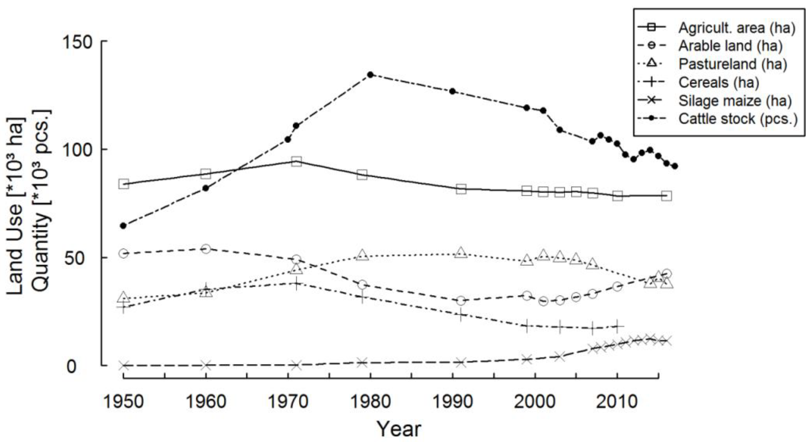
2.1. Characterization of the Study Area
2.2. Remote Sensing Based Classification of Maize Fields
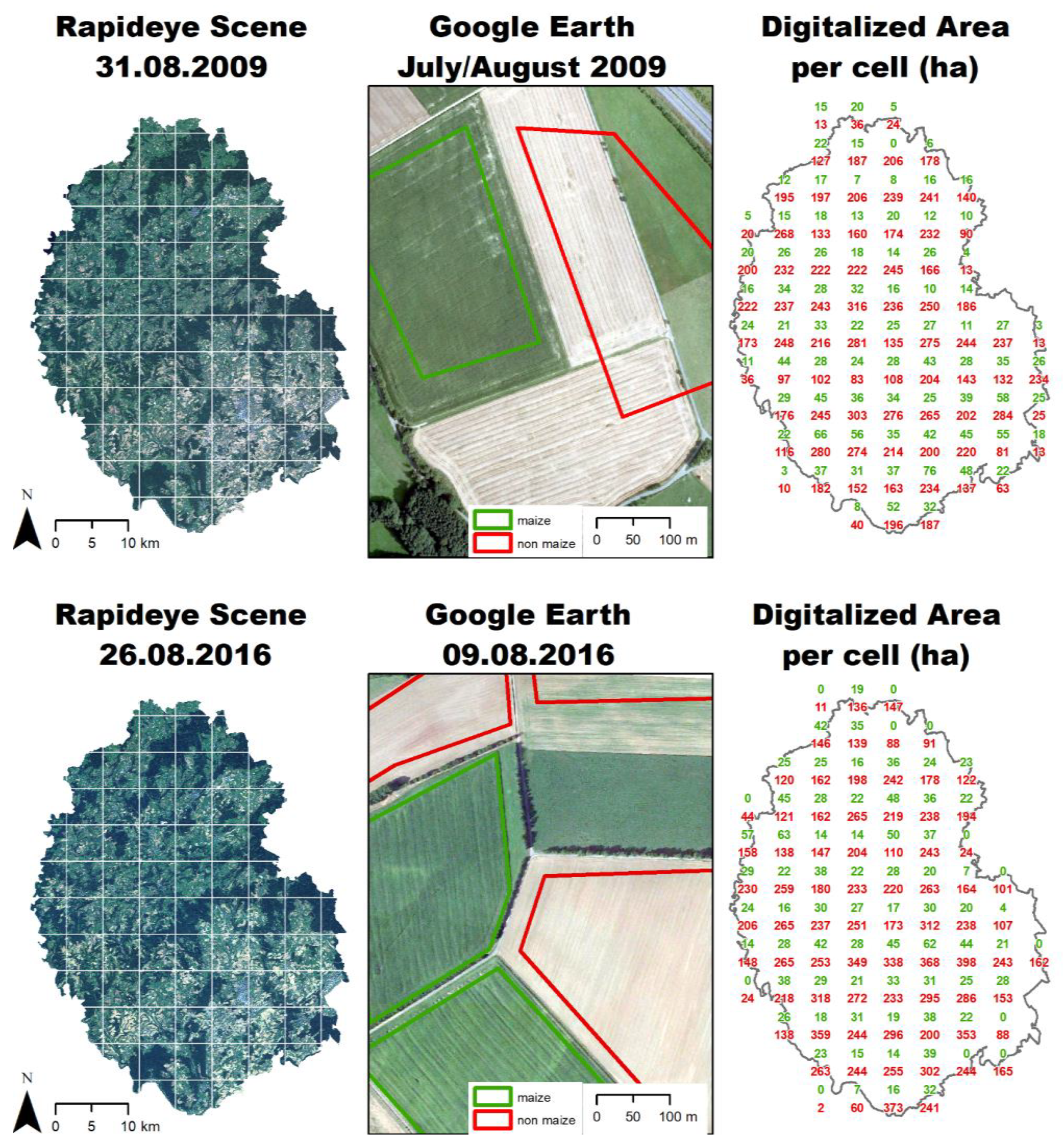
2.2.1. Selection and Pre-Processing of Remote Sensing Data
2.2.2. Preparation of Reference Data
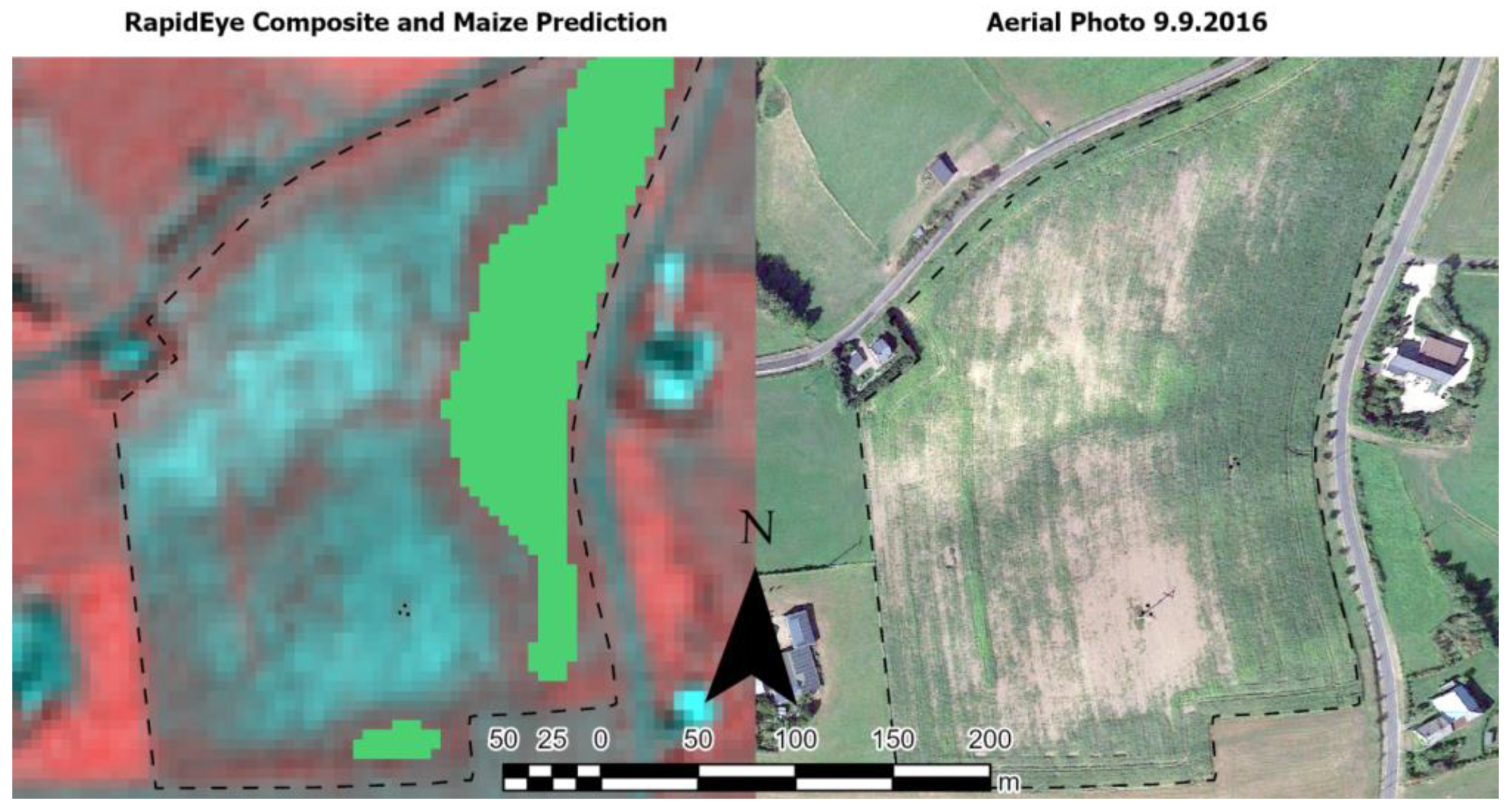
2.2.3. Pixel-Based Classification of Imagery
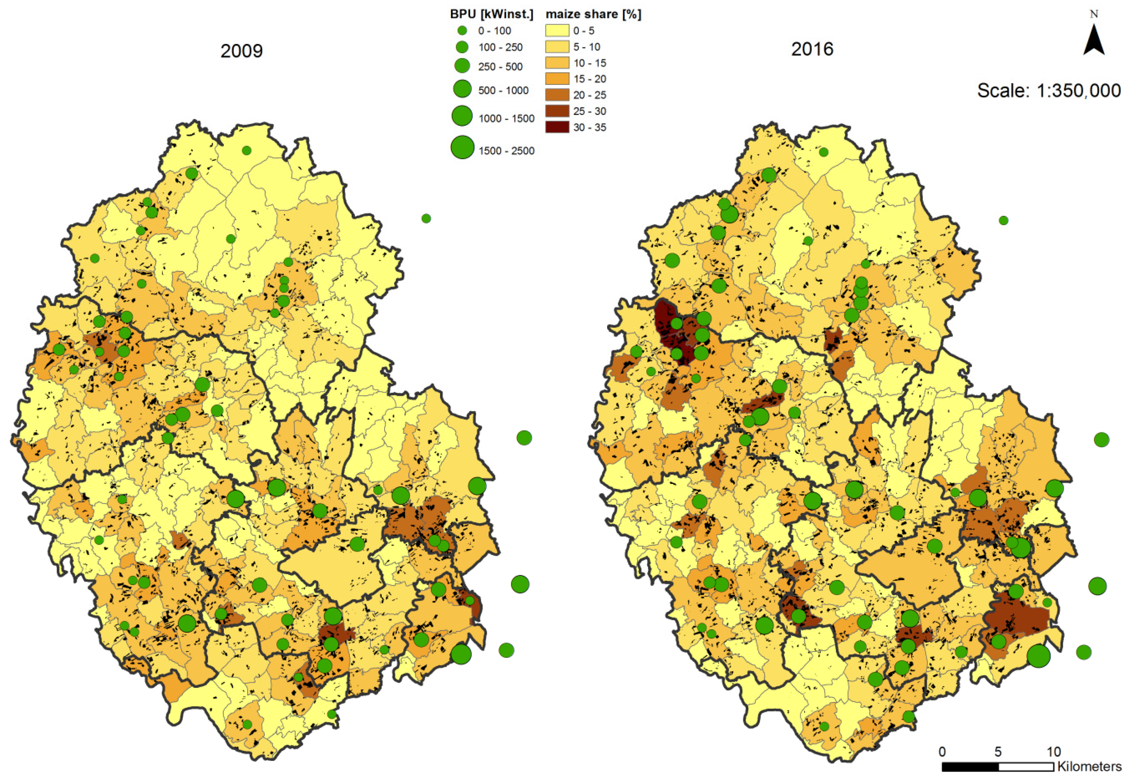
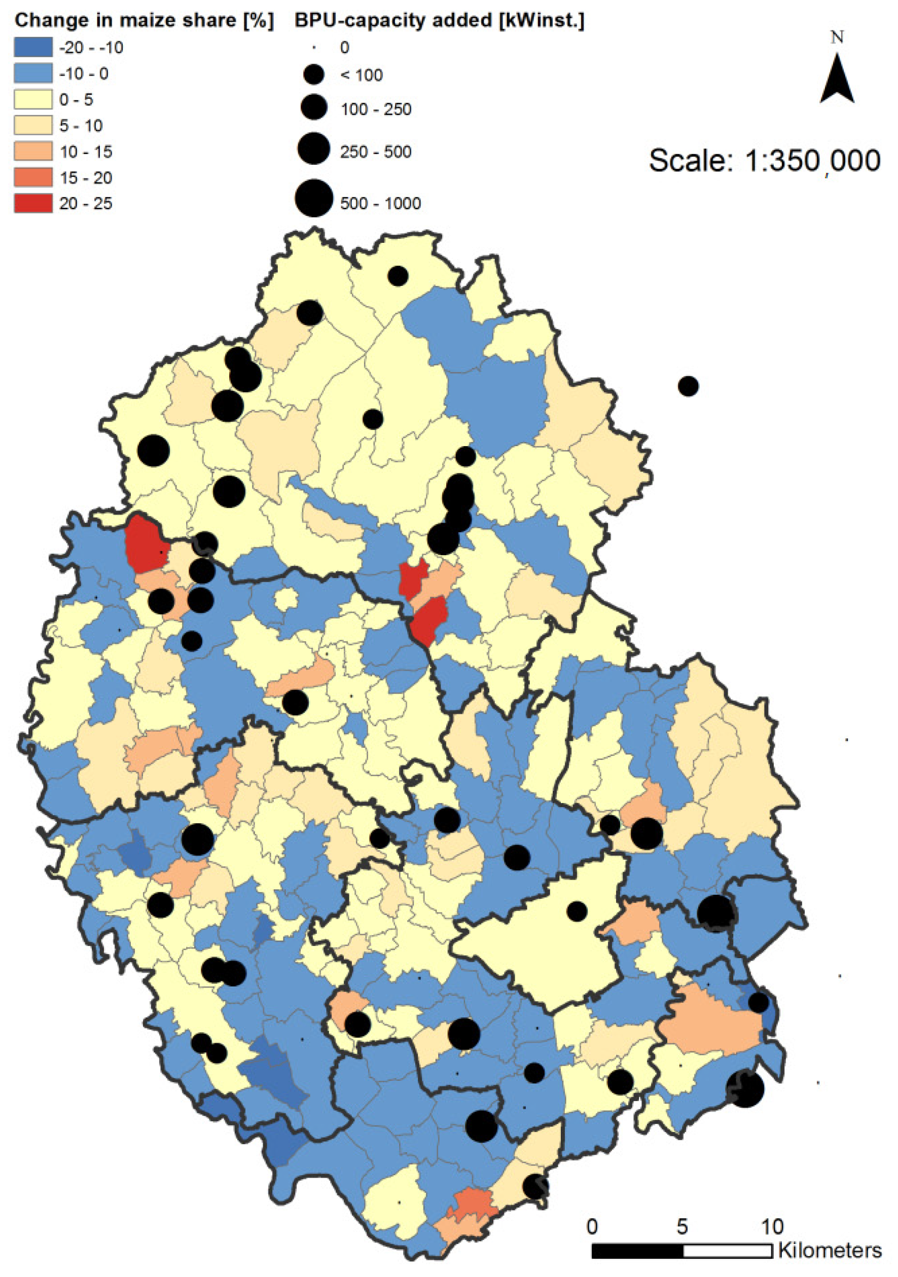
2.3. Agricultural Biogas Producing Units
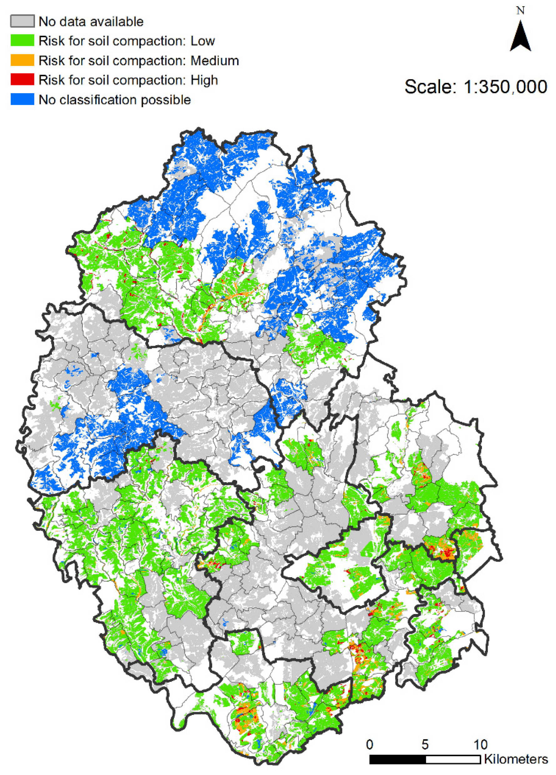
2.4. Determining of Pedotopes Susceptible for Compaction during Maize Harvesting
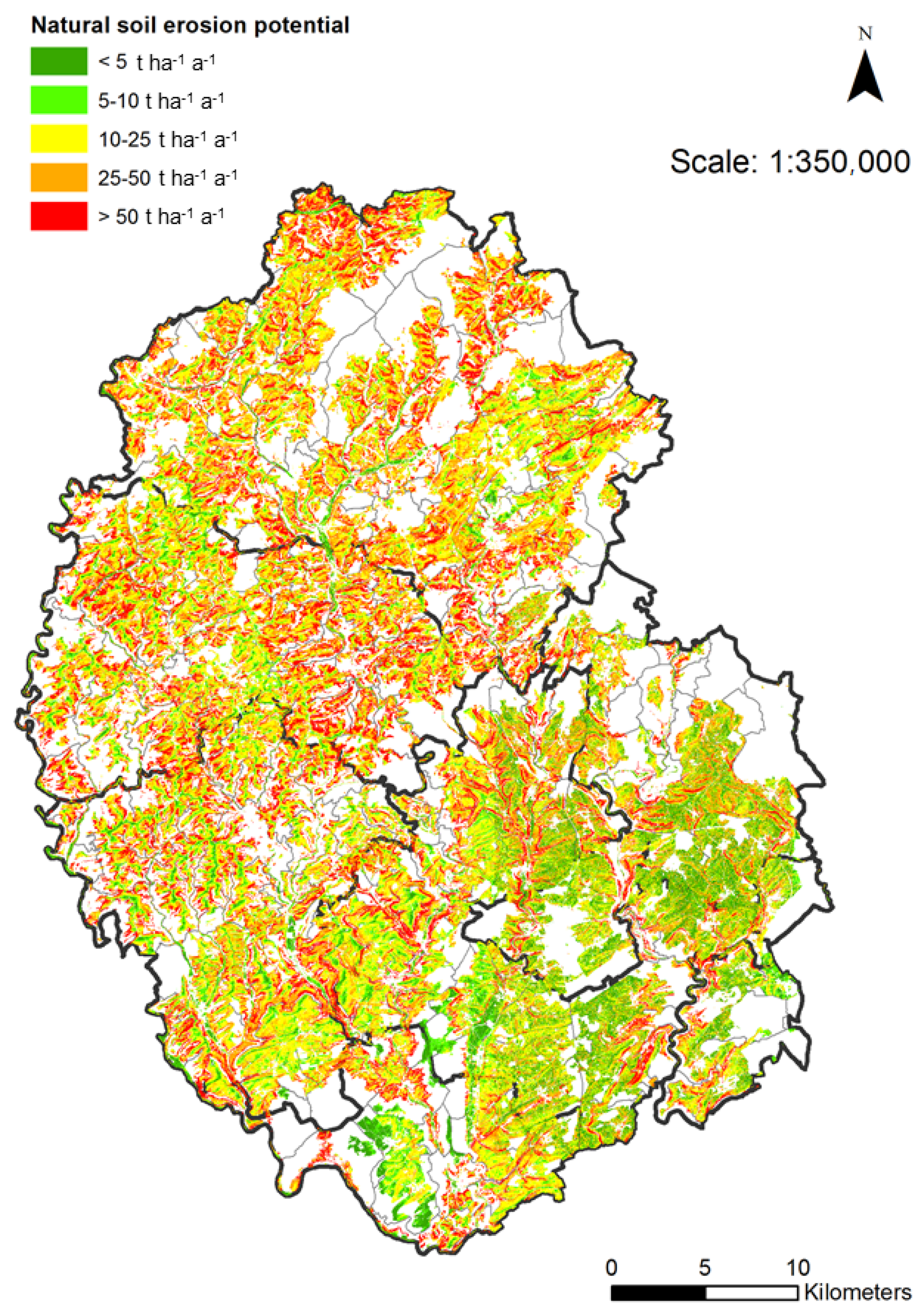
2.5. Determining of Site-Specific Susceptibility for Soil Erosion by Water
- Soil erodibility factor (K): Derived from the soil texture of the topsoil determined in the framework of the German land appraisal. Textures were then assigned to K factors and corrected by soil skeleton and organic carbon contents using Equations (3)–(6), given in [33]. Values of the K factor for the study area with a raster resolution of 5 m by 5 m were provided by the State Office for Geology and Mining Rhineland Palatinate.
- Rainfall and runoff factor (R): R factors were calculated using the following regression equation: R = 0.0788 * mean annual precipitation (in mm) * −2.82 which was valid for the Federal Republic of Germany. Values of the R factor for the study area with a raster resolution of 1 km by 1 km were provided by the State Office for Geology and Mining Rhineland Palatinate.
2.6. Data Analysis and Mapping
3. Results and Discussions
3.1. Maize Classification
3.2. Extent and Changes in Silage Maize Cultivation in the Study Area
3.3. Maize Cultivation on Pedotopes Susceptible for Soil Compaction
3.4. Natural Susceptibility of the Soils for Erosion and Threats to Soil Due to Maize Cultivation
4. Conclusions
Supplementary Materials
Author Contributions
Funding
Data Availability Statement
Acknowledgments
Conflicts of Interest
References
- Braun, R.; Weiland, P.; Wellinger, A. Biogas from Energy Crop Digestion. IEA Bioenergy Task 37: Energy from Biogas and Landfill Gas. 2010. Available online: http://task37.ieabioenergy.com/files/daten-redaktion/download/energycrop_def_Low_Res.pdf (accessed on 12 September 2018).
- Lupp, G.; Albrecht, J.; Darbi, M.; Bastian, O. Ecosystem services in energy crop production: A concept for regulatory measures in spatial planning? J. Landsc. Ecol. 2011, 4, 49–66. [Google Scholar] [CrossRef]
- Erneuerbare-Energien-Gesetz (EEG), Gesetz für den Ausbau Erneuerbarer Energien vom 21. Juli 2014 (BGBl. I S. 1066, Berlin), das Durch Artikel 2 des Gesetzes vom 22. Dezember 2016 (BGBl. I S. 3106, Berlin) Geändert Worden Ist. Available online: https://www.gesetze-im-internet.de/eeg_2014/BJNR106610014.html (accessed on 14 September 2020).
- Deutsches Biomasseforschungszentrum (DBFZ). Anlagenbestand Biogas und Biomethan—Biogaserzeugung und–Nutzung in Deutschland; Report Nr. 30; DBFZ: Leipzig, Germany, 2017. [Google Scholar]
- Fachagentur Nachwachsende Rohstoffe (FNR). Basisdaten Bioenergie Deutschland 2014. Festbrennstoffe, Biokraftstoffe, Biogas; Bestell-Nr. 469; FNR: Gülzow-Prüzen, Germany, 2014. [Google Scholar]
- Fachagentur Nachwachsende Rohstoffe (FNR). Basisdaten Bioenergie Deutschland 2018. Festbrennstoffe, Biokraftstoffe, Biogas; FNR: Gülzow-Prüzen, Germany, 2018; Available online: http://www.fnr.de/fileadmin/allgemein/pdf/broschueren/Basisdaten_Bioenergie_2018.pdf (accessed on 11 September 2018).
- KTBL (Kuratorium für Technik und Bauwesen in der Landwirtschaft e.V.). Energiepflanzen. Daten für die Planung des Energiepflanzenanbaus, 2nd ed.; KTBL: Darmstadt, Germany, 2012. [Google Scholar]
- Weiland, P. Biogas production: Current state and perspectives. Appl. Microbiol. Biotechnol. 2010, 85, 849–860. [Google Scholar] [CrossRef] [PubMed]
- Adler, P.R.; Del Grosso, S.J.; Parton, W.J. Life-cycle assessment of the net greenhouse-gas flux for bioenergy cropping systems. Ecol. Appl. 2007, 17, 675–691. [Google Scholar] [CrossRef] [PubMed]
- Blanco-Canqui, H. Energy crops and their implications on soil and environment. Agron. J. 2010, 102, 403–419. [Google Scholar] [CrossRef]
- Herrmann, A. Biogas production from maize: Current state, challenges and prospects. 2. Agronomic and environmental aspects. BioEnergy Resear. 2013, 6, 372–387. [Google Scholar]
- Immerzeel, D.J.; Verweij, P.A.; van der Hilst, F.; Faaij, A.P.C. Biodiversity impacts of bioenergy crop production: A state-of-the-art review. Glob. Chang. Biol. Bioenergy 2014, 6, 183–209. [Google Scholar] [CrossRef]
- Statistisches Landesamt Rheinland-Pfalz (Statistical Office Rhineland-Palatinate). Statistisches Jahrbuch 2017, Rheinland-Pfalz; Statistisches Landesamt Rheinland-Pfalz: Sinzig, Germany, 2017. [Google Scholar]
- DLR Mosel, Daten zum Silomaisanbau in der Region Trier und in Rheinland-Pfalz. 2018. Available online: http://www.dlr-mosel.rlp.de/Internet/global/themen.nsf/d0e5087e9e1e8b79c1257abf0060c5df/b7c65bbd218ffd94c1257c1c004c2c99?OpenDocument (accessed on 12 September 2018).
- Statistisches Landesamt Rheinland-Pfalz (Statistical Office Rhineland-Palatinate). Statistische Bände: Die Landwirtschaft mit Vergleichszahlen seit 1949; Statistisches Landesamt Rheinland-Pfalz: Bad Ems, Germany, 1949; multiple years. [Google Scholar]
- Von Francken-Welz, H.; Wenghoefer, V.; Hamilton, V. Biogasanlagen in Rheinland-Pfalz 2017. 5. Betriebserhebung Biogas. Dienstleistungszentrum Ländlicher Raum Eifel (publ.), Germany. 2017. Available online: http://www.dlreifel.rlp.de/Internet/global/themen.nsf/3377acc1e3e31fb8c12579f000322e61/c661a290b8aef10ec12581f300343635/$FILE/Biogaserhebung2017_final.pdf (accessed on 18 July 2018).
- Landesamt für Vermessung und Geobasisinformation Rheinland-Pfalz (LVermGeo). Digital Elevation Model with a Grid Width of 5 m (DEM5); Landesamt für Vermessung und Geobasisinformation Rheinland-Pfalz (LVermGeo): Koblenz, Germany, 2018. [Google Scholar]
- Steingötter, K. Geologie von Rheinland-Pfalz. Landesamt für Geologie und Bergbau Rheinland-Pfalz (Hrsg.); E. Schweitzerbart’sche Verlagsbuchhandlung (Nägele u. Obermiller): Stuttgart, Germany, 2005. [Google Scholar]
- German Meteorological Service, Climate Data Center. Available online: ftp://ftp-cdc.dwd.de/pub/CDC/observations_germany/climate/multi_annual/mean_81-10/ (accessed on 20 July 2018).
- Landesamt für Geologie und Bergbau Rheinland-Pfalz (LGB-RLP) (State Office for Geology and Mining Rhineland-Palatinate): Geologische Übersichtskarte von Rheinland-Pfalz: Online Karte GÜK 300. 2018. Available online: http://www.lgbrlp.de/karten-und-produkte/online-karten/online-karte-guek-300.html (accessed on 18 July 2018).
- Landesamt für Geologie und Bergbau Rheinland-Pfalz (LGB-RLP) (State Office for Geology and Mining Rhineland-Palatinate) Bodenflächendaten 1:200,000. 2018. Available online: http://www.lgb-rlp.de/karten-und-produkte/wms-dienste.html (accessed on 18 July 2018).
- Wagner, W.; Negendank, J.F.W.; Fuchs, G.; Mittmeyer, H.G. Geologische Übersichtskarte: Rheinisches Schiefergebirge SW-Teil 1:100,000; Geologisches Landesamt Rheinland-Pfalz, Ed.; Geologisches Landesamt Rheinland-Pfalz: Mainz, Germany, 1983. [Google Scholar]
- Tanré, D.; Deroo, C.; Duhaut, P.; Herman, M.; Morcrette, J.J.; Perbos, J.; Deschamps, P.Y. Technical note. Description of a computer code to simulate the satellite signal in the solar spectrum: The 5S code. Int. J. Remote Sens. 1990, 11, 659–668. [Google Scholar] [CrossRef]
- Hill, J.; Sturm, B. Radiometric correction of multitemporal Thematic Mapper data for use in agricultural land-cover classification and vegetation monitoring. Int. J. Remote Sens. 1991, 12, 1471–1491. [Google Scholar] [CrossRef]
- Hill, J.; Mehl, W.; Radeloff, V. Improved forest mapping by combining corrections of atmospheric and topographic effects in Landsat TM imagery. In Sensors and Environmental Applications of Remote Sensing, Proceedings of the 14th EARSel Symposium, Goteborg, Sweden, 6–8 June 1994; Askne, J., Ed.; Chalmers University of Technology: Göteburg, Sweden, 1995; pp. 143–151. [Google Scholar]
- R Core Team. R: A Language and Environment for Statistical Computing; R Foundation for Statistical Computing: Vienna, Austria, 2016; Available online: https://www.R-project.org/ (accessed on 19 January 2021).
- Wright, M.N.; Ziegler, A. Ranger: A fast implementation of random forests for high dimensional data in C++ and R. J. Stat. Softw. 2017, 77, 1–17. [Google Scholar] [CrossRef]
- Breiman, L. Random Forests. Mach. Learn. 2001, 45, 5–32. [Google Scholar] [CrossRef]
- Belgiu, M.; Draăgut, L. Random forest in remote sensing: A review of applications and future directions. ISPRS J. Photogramm. Remote Sens. 2016, 114, 24–31. [Google Scholar] [CrossRef]
- Ad-hoc-AG Boden. Bodenkundliche Kartieranleitung, 5th ed.; E. Schweizerbart’sche Verlagsbuchhandlung: Stuttgart, Germany, 2005. [Google Scholar]
- Food and Agriculture Organization of the United Nations (FAO). Guidelines for Soil Description, 4th ed.; FAO: Rome, Italy, 2006. [Google Scholar]
- Bodenschätzungsgesetz (BodSchätzG), Gesetz zur Schätzung des landwirtschaftlichen Kulturbodens vom 20. Dezember 2007 (Bundesgesetzblatt I S. 3150, 3176, Berlin), das durch Artikel 232 der Verordnung vom 31. August 2015 (Bundesgesetzblatt I S. 1474, Berlin) Geändert Worden ist. Available online: http://www.gesetze-im-internet.de/bodsch_tzg_2008/BodSchätzG.pdf (accessed on 14 September 2020).
- Deutsches Institut für Normung (DIN). 19708:2017-08: Soil Quality: Predicting Soil Erosion by Water by Means of the USLE (Bodenbeschaffenheit: Ermittlung der Erosionsgefährdung von Böden Durch Wasser Mithilfe der ABAG); Beuth-Verlag: Berlin, Germany, 2017. [Google Scholar]
- Wischmeier, W.; Smith, D. Predicting Rainfall Erosion Losses: A Guide to Conservation Planning; Agriculture Handbook No. 537; U.S. Department of Agriculture: Hyattsville, MD, USA, 1978.
- Blume, H.-P.; Brümmer, G.W.; Fleige, H.; Horn, R.; Kandeler, E.; Kögel-Knabner, I.; Kretzschmar, R.; Stahr, K.; Wilke, B.-M. Scheffer/Schachtschabel. Soil Science; Springer: Berlin/Heidelberg, Germany, 2016. [Google Scholar]
- Zech, W.; Schad, P.; Hintermaier-Erhard, G. Böden der Welt. Ein Bildatlas, 2nd ed.; Springer Spektrum: Berlin/Heidelberg, Germany, 2014. [Google Scholar]
- Kuhwald, M.; Dörnhöfer, K.; Oppelt, N.; Duttmann, R. Spatially explicit soil compaction risk assessment of arable soils at regional scale: The SaSCiA-Model. Sustainability 2018, 10, 1618. [Google Scholar] [CrossRef]
- Lebert, M. Entwicklung Eines Prüfkonzeptes zur Erfassung der tatsächlichen Verdichtungsgefährdung Landwirtschaftlich Genutzter Böden. UBA-Texte 51/2010, Förderkennzeichen: 370771202. Available online: https://www.umweltbundesamt.de/sites/default/files/medien/461/publikationen/4027.pdf (accessed on 1 April 2019).
- Ruf, T.; Audu, V.; Holzhauser, K.; Emmerling, C. Bioenergy from periodically waterlogged cropland in Europe: A first assessment of the potential of five perennial energy crops to provide biomass and their interactions with soil. Agronomy 2019, 9, 374. [Google Scholar] [CrossRef]
- Schoo, B.; Schroetter, S.; Kage, H.; Schittenhelm, S. Root traits of cup plant, maize and lucerne grass grown under different soil and soil moisture conditions. J. Agron. Crop Sci. 2017, 203, 345–359. [Google Scholar]
- Saggau, P.; Bug, J.; Gocht, A.; Kruse, K. Aktuelle Bodenerosionsgefährdung durch Wind und Wasser in Deutschland. Bodenschutz 2017, 22, 120–125. [Google Scholar]
- European Union. EU Regulation No 1306/2013, Regulation of the European Parliament and of the Council of 17 December 2013 on the Financing, Management and Monitoring of the Common Agricultural Policy and Repealing Council Regulations (EEC) No 352/78, (EC) No 165/94, (EC) No 2799/98, (EC) No 814/2000, (EC) No 1290/2005 and (EC) No 485/2008; EU: Brussels, Belgium, 2013. [Google Scholar]
- AgrarZahlVerpflG Gesetz zur Regelung der Einhaltung von Anforderungen und Standards im Rahmen Unionsrechtlicher Vorschriften über Agrarzahlungen. Agrarzahlungen-Verpflichtungengesetz vom 2. Dezember 2014 (Bundesgesetzblatt I S. 1928, Berlin). Available online: https://www.gesetze-im-internet.de/agrarzahlverpflg/AgrarZahlVerpflG.pdf (accessed on 14 September 2020).
- AgrarZahlVerpflV Verordnung über die Einhaltung von Grundanforderungen und Standards im Rahmen Unionsrechtlicher Vorschriften über Agrarzahlungen. Agrarzahlungen-Verpflichtungenverordnung vom 17. Dezember 2014 (BAnz AT 23.12.2014 V1, Berlin), die Zuletzt Durch Artikel 2 der Verordnung vom 27. September 2018 (BAnz AT 28.09.2018 V1, Berlin) Geändert Worden ist. Available online: https://www.gesetze-im-internet.de/agrarzahlverpflv/AgrarZahlVerpflV.pdf (accessed on 14 September 2020).
- Auerswald, K.; Fischer, F.K.; Kistler, M.; Treisch, M.; Maier, H.; Brandhuber, R. Behavior of farmers in regard to erosion by water as reflected by their farming practices. Sci. Total Environ. 2018, 613–614, 1–9. [Google Scholar] [CrossRef]
- Panagos, P.; Borrelli, P.; Meusburger, K.; Alewell, C.; Lugato, E.; Montanarella, L. Estimating the soil erosion cover-management factor at the European scale. Land Use Policy 2015, 48, 38–50. [Google Scholar] [CrossRef]
- Schwertmann, U.; Vogl, W.; Kainz, M. Bodenerosion Durch Wasser. Vorhersage des Abtrags und Bewertung von Gegenmaßnahmen; Verlag Eugen Ulmer: Stuttgart, Germany, 1987. [Google Scholar]
- European Environmental Agency (EEA). Climate Change, Impacts and Vulnerability in Europe 2016: An Indicator-Based Report (EEA Report No 1/2017); European Environment Agency: Copenhagen, Denmark, 2017.
- Sauerborn, P. Die Erosivität der Niederschläge in Deutschland—Ein Beitrag zur quantitativen Prognose der Bodenerosion durch Wasser in Mitteleuropa. In Bonner Bodenkundliche Abhandlungen; Band 13; Universität Bonn: Bonn, Germany, 1994. [Google Scholar]
- Auerswald, K.; Fischer, F.K.; Winterrath, T.; Brandhuber, R. Rain erosivity map for Germany derived from contiguous radar rain data. Hydrol. Earth Syst. Sci. 2019, 23, 1819–1832. [Google Scholar] [CrossRef]
- Rogler, H.; Schwertmann, U. Erosivität der Niederschläge und Isoerodentkarte Bayerns. Z. Kult. Flurberein. 1981, 22, 99–112. [Google Scholar]
- Auerswald, K.; Fischer, F.; Winterrath, T.; Elhaus, D.; Maier, H.; Brandhuber, R. Klimabedingte Veränderung der Regenerosivität seit 1960 und Konsequenzen für Bodenabtragsschätzungen. In Bodenschutz, Ergänzbares Handbuch der Maßnahmen und Empfehlungen für Schutz, Pflege und Sanierung von Böden, Landschaft und Grundwasser (Loseblattsammlung); Bachmann, G., König, W., Utermann, J., Eds.; Erich Schmidt Verlag: Berlin, Germany, 2019. [Google Scholar]
- Gilcher, M.; Ruf, T.; Emmerling, C.; Udelhoven, T. Remote sensing based binary classification of maize. Dealing with residual autocorrelation in sparse sample situations. Remote Sens. 2019, 11, 2172. [Google Scholar] [CrossRef]


| Year | Sensitivity | Specificity | Kappa |
|---|---|---|---|
| 2009 | >0.99 | ~0.97 | ~0.97 |
| 2016 | >0.99 | ~0.91 | ~0.93 |
| Susceptibility for Soil Compaction | Soil Types |
|---|---|
| High | Stagnosols, Planosols |
| Medium |
|
| Low | All other soil types |
| Soil Erosion Potential | Soil Loss acc. to Enat |
|---|---|
| t ha−1 a−1 | |
| Very low | <5 |
| Low | 5–10 |
| Medium | 10–25 |
| High | 25–50 |
| Very high | >50 |
| Year | Remote-Sensing Based Approach | Statistical Data | Difference between stat. Data and Remote-Sensing Based Approach | |
|---|---|---|---|---|
| ha | ha | ha | % | |
| 2009 | 7305 | 9147 | −1842 | −20.1 |
| 2016 | 8447 | 11496 | −3049 | −26.5 |
| Agricultural Area | Maize 2009 | Maize 2016 | |||||
|---|---|---|---|---|---|---|---|
| ha | % | ha | % | ha | % | ||
| Total | 87,422 | 100 | 7305 | 100 | 8447 | 100 | |
| Classifiable | 31,706 | 36.3 | 2867 | 39.2 | 3249 | 38.5 | |
| Vulnerability for soil compaction | Low | 28,758 | 90.7 | 2567 | 89.5 | 2997 | 92.2 |
| Medium | 2226 | 7.0 | 252 | 8.8 | 195 | 6.0 | |
| High | 722 | 2.3 | 48 | 1.7 | 57 | 1.8 | |
| Erosion Potential | Agricultural Area | 2009 | 2016 | |||||||
|---|---|---|---|---|---|---|---|---|---|---|
| Maize | Non-Maize | Maize | Non-Maize | |||||||
| ha | % | ha | % | ha | % | ha | % | ha | % | |
| Very low | 8335 | 9.5 | 724 | 10.4 | 7611 | 9.5 | 791 | 9.7 | 7545 | 9.5 |
| Low | 9268 | 10.6 | 1034 | 14.8 | 8233 | 10.2 | 1147 | 14.1 | 8121 | 10.2 |
| Medium | 29,414 | 33.7 | 3045 | 43.6 | 26,369 | 32.8 | 3508 | 43.2 | 25,906 | 32.7 |
| High | 25,126 | 28.8 | 1846 | 26.5 | 23,280 | 29.0 | 2249 | 27.7 | 22,877 | 28.9 |
| Very high | 15,256 | 17.5 | 330 | 4.7 | 14,926 | 18.6 | 426 | 5.3 | 14830 | 18.7 |
Publisher’s Note: MDPI stays neutral with regard to jurisdictional claims in published maps and institutional affiliations. |
© 2021 by the authors. Licensee MDPI, Basel, Switzerland. This article is an open access article distributed under the terms and conditions of the Creative Commons Attribution (CC BY) license (http://creativecommons.org/licenses/by/4.0/).
Share and Cite
Ruf, T.; Gilcher, M.; Udelhoven, T.; Emmerling, C. Implications of Bioenergy Cropping for Soil: Remote Sensing Identification of Silage Maize Cultivation and Risk Assessment Concerning Soil Erosion and Compaction. Land 2021, 10, 128. https://doi.org/10.3390/land10020128
Ruf T, Gilcher M, Udelhoven T, Emmerling C. Implications of Bioenergy Cropping for Soil: Remote Sensing Identification of Silage Maize Cultivation and Risk Assessment Concerning Soil Erosion and Compaction. Land. 2021; 10(2):128. https://doi.org/10.3390/land10020128
Chicago/Turabian StyleRuf, Thorsten, Mario Gilcher, Thomas Udelhoven, and Christoph Emmerling. 2021. "Implications of Bioenergy Cropping for Soil: Remote Sensing Identification of Silage Maize Cultivation and Risk Assessment Concerning Soil Erosion and Compaction" Land 10, no. 2: 128. https://doi.org/10.3390/land10020128
APA StyleRuf, T., Gilcher, M., Udelhoven, T., & Emmerling, C. (2021). Implications of Bioenergy Cropping for Soil: Remote Sensing Identification of Silage Maize Cultivation and Risk Assessment Concerning Soil Erosion and Compaction. Land, 10(2), 128. https://doi.org/10.3390/land10020128