
An Analysis of an Area’s Vulnerability to the Emergence of Land-Use Conflicts


Abstract
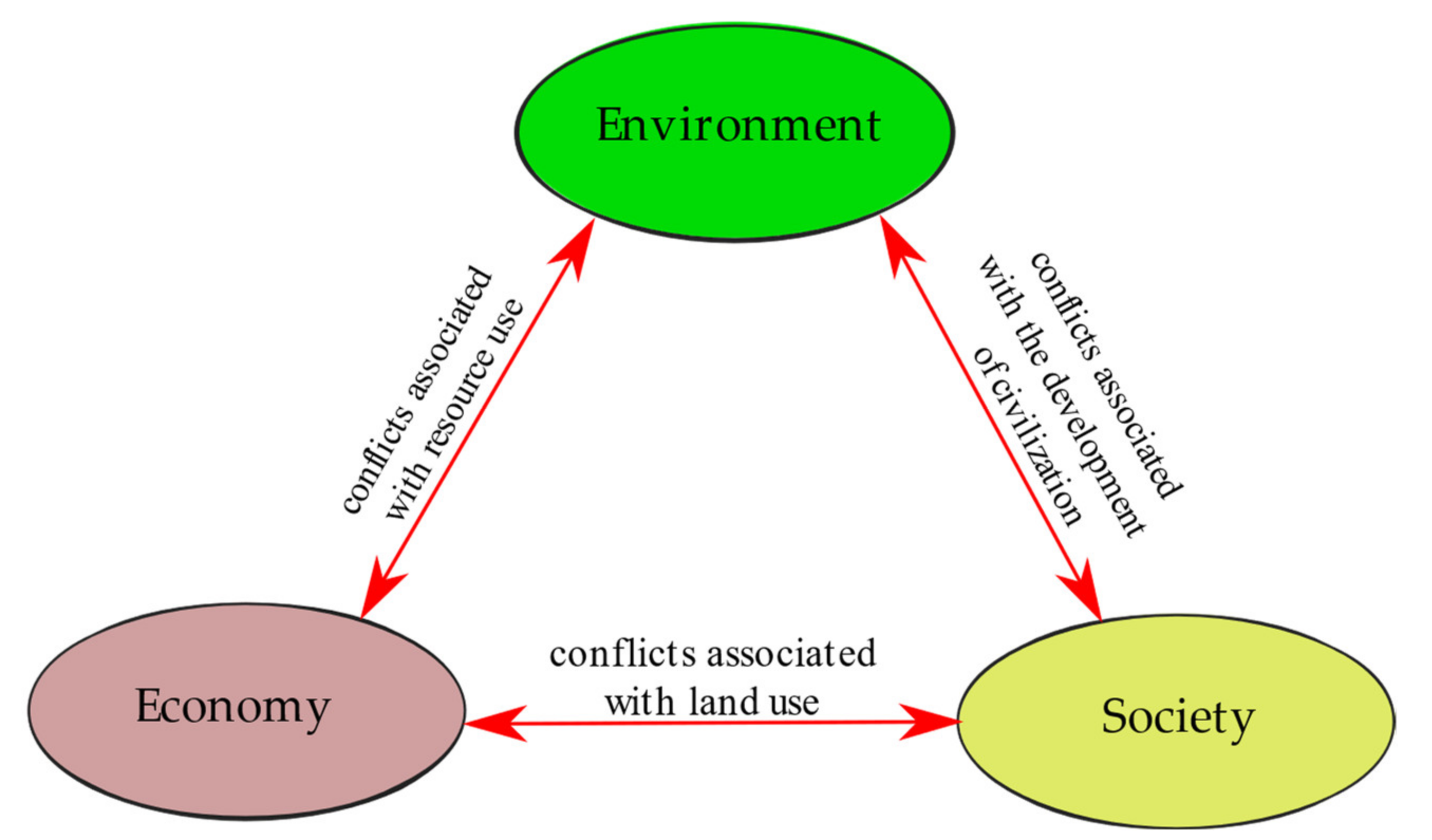
1. Introduction
- 1.
- Value system factors:
- 1.1.
- The parties have different values and aims;
- 1.2.
- The parties take different measures to represent their aims;
- 1.3.
- The parties have different preference hierarchies (for example, by applying different weights for different solutions);
- 2.
- Effect distribution factors:
- 2.1.
- The parties can incur different costs and derive various indirect benefits associated with the anticipated effects of their actions;
- 2.2.
- The breakdown of costs and benefits is perceived as uneven and unfair;
- 3.
- Uncertainty factors:
- 3.1.
- The parties cannot reach agreement on the probable effects of actions;
- 3.2.
- The parties are not certain of the effects of their actions;
- 3.3.
- The evidence and the rationale behind the effects of their actions may be insufficient or incomprehensible;
- 3.4.
- The parties may have doubts about the associations between the effects of an action and other actions;
- 4.
- Process factors:
- 4.1.
- The parties find it difficult to exchange information about their values, aims, criteria, preferences, and expectations.
- -
- space in the geodetic sense:
- cadastral plot;
- building;
- property boundaries.
- -
- land-use rights:
- ownership, perpetual usufruct, co-ownership;
- other rights to derive income from land: easement, lease, tenure, etc.;
- specific land-use (land management) rights.
- -
- space in the geographic sense:
- immediate space (own—private);
- local space (neighborhood, municipality);
- regional and ethnic space;
- national space;
- global space.
- -
- high population density;
- -
- major cultural and political differences among local community members;
- -
- number of households;
- -
- differences in educational attainment.
- -
- land prices;
- -
- unemployment;
- -
- differences in economic status;
- -
- sources of income (different types of employment).
- -
- real estate prices;
- -
- fragmentation of ownership (fragmentation of cadastral plots);
- -
- development density;
- -
- building height;
- -
- length of property boundaries;
- -
- diverse land-use types in the immediate neighborhood;
- -
- large area of ecologically valuable land.
2. Materials and Methods
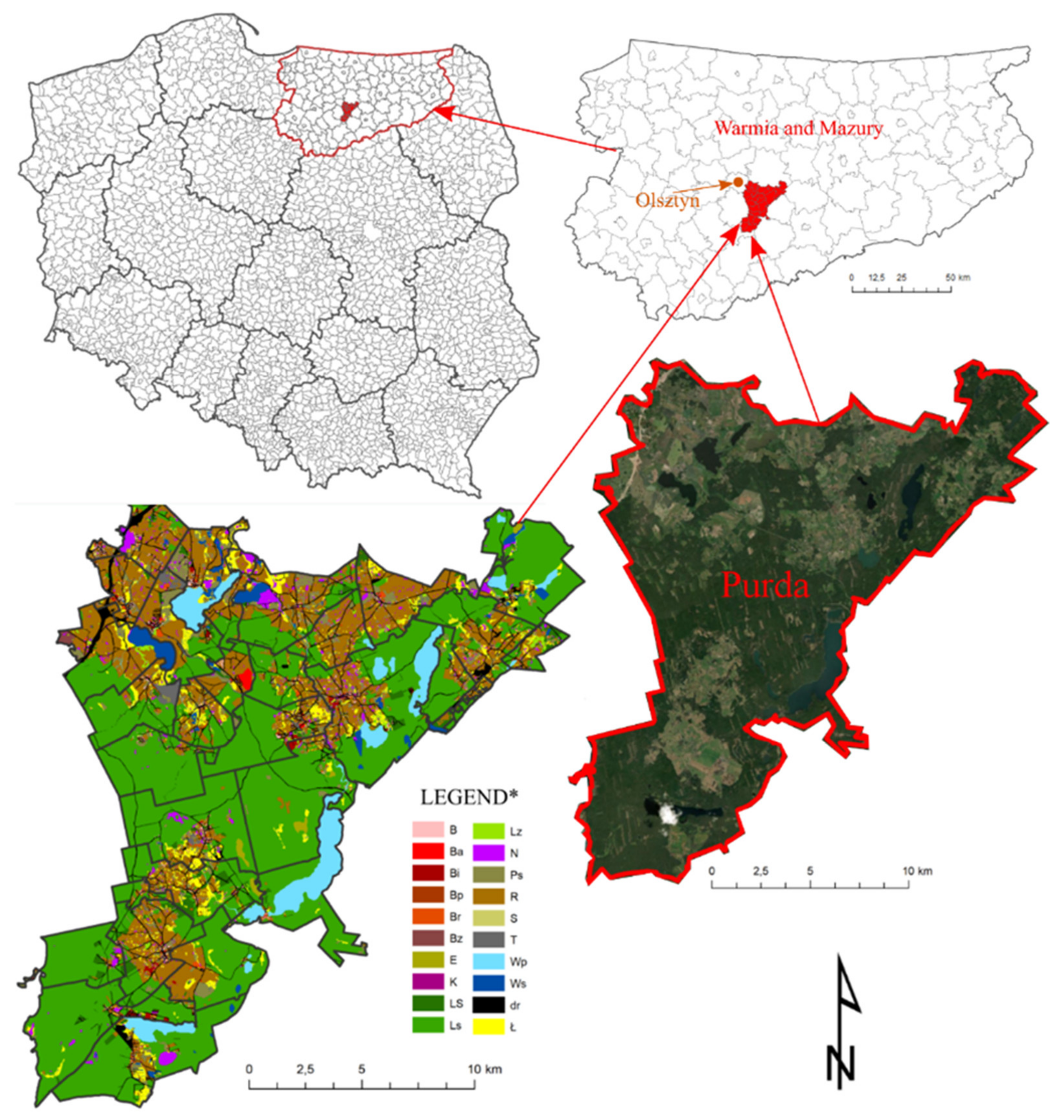
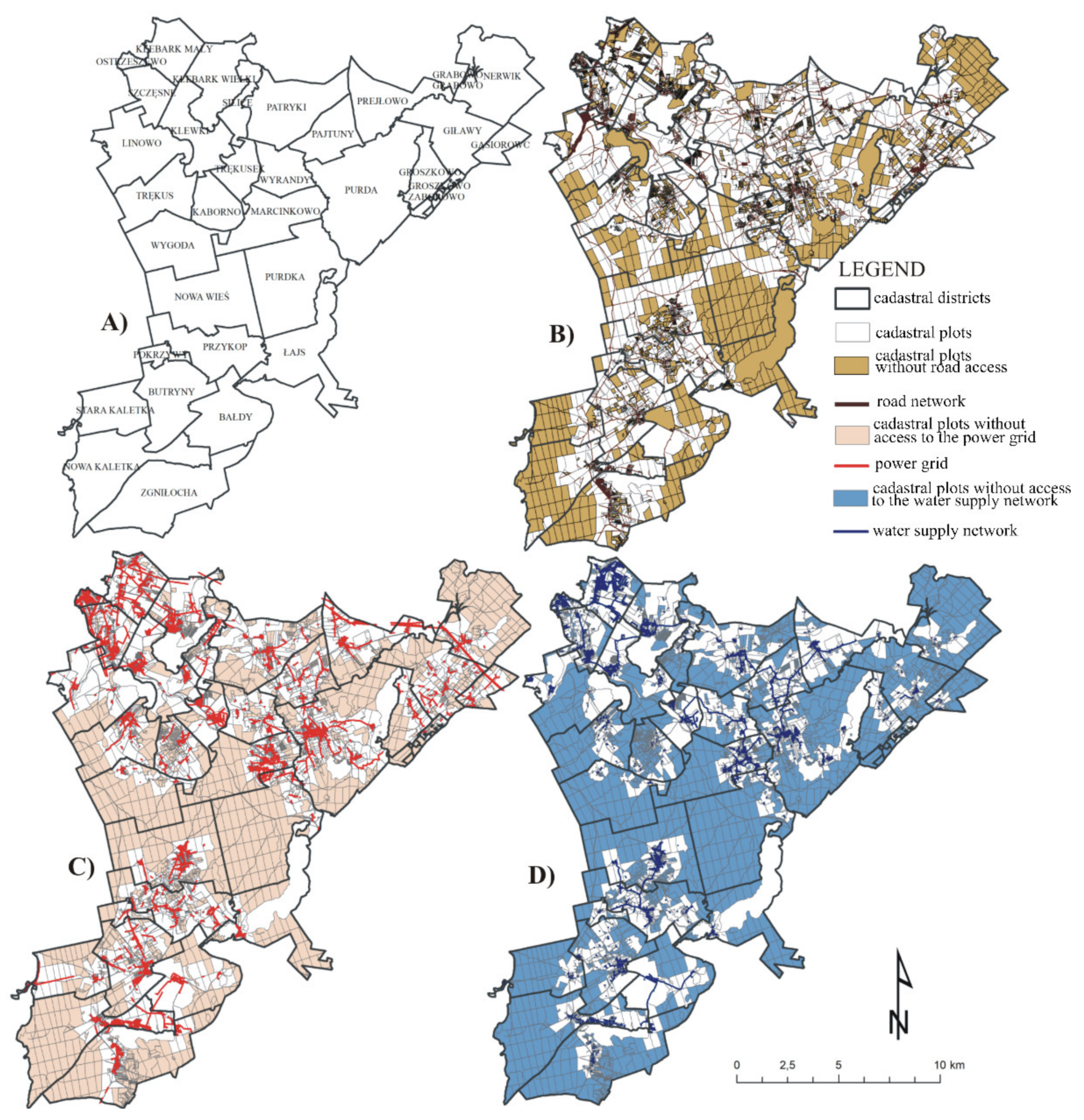
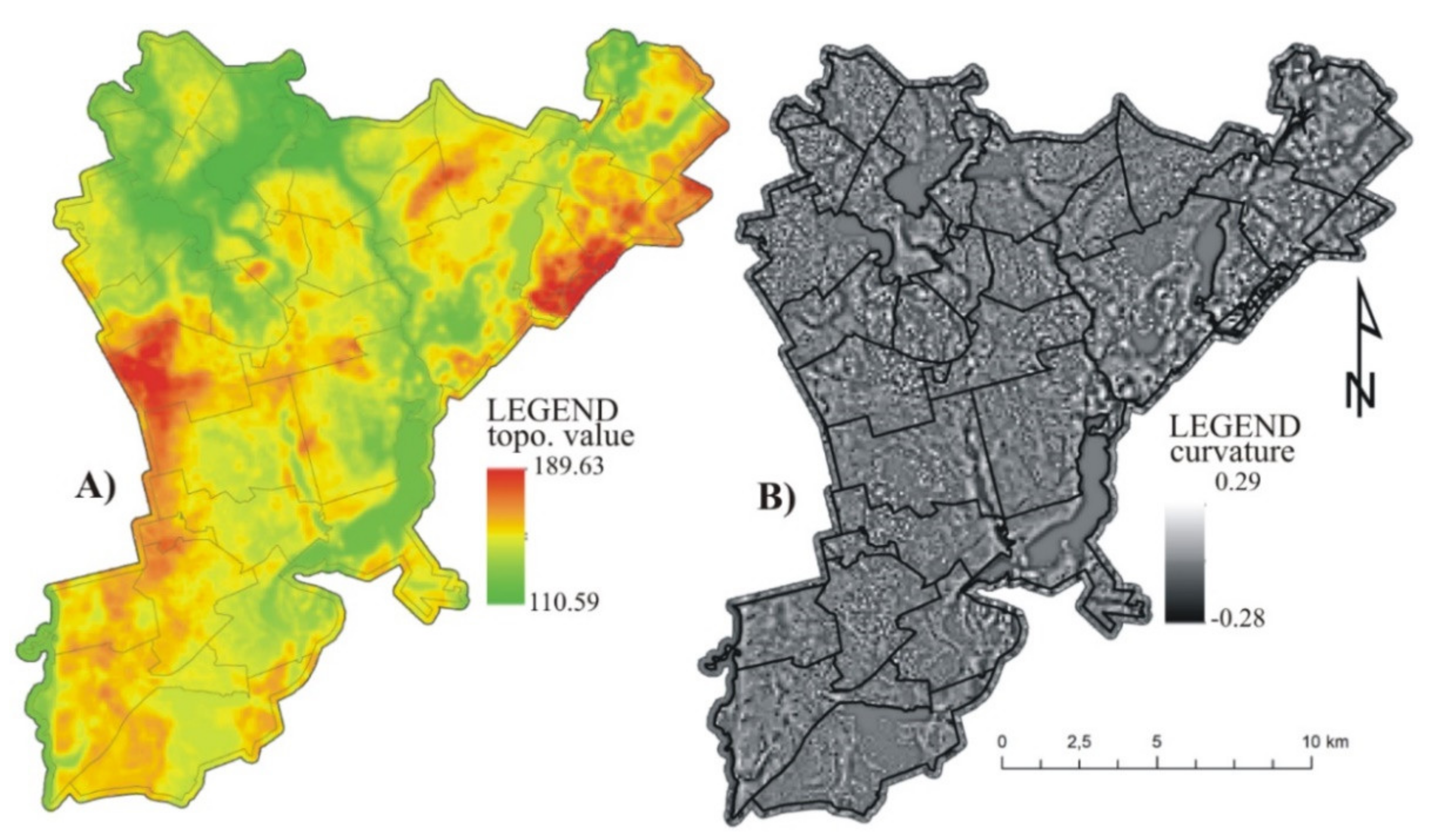
2.1. Study Area and Data
2.2. Methodology
3. Results and Discussion
4. Conclusions
Author Contributions
Funding
Conflicts of Interest
References
- Mucha, J. Konflikt I Społeczeństwo: Z Problematyki Konfliktu Społecznego We Współczesnych Teoriach Zachodnich; PWN: Warszawa, Poland, 1978. [Google Scholar]
- Pietrzak, H. Agresja, Konflikt, Społeczeństwo; College of Socio-Economics: Tyczyn, Poland, 2000. [Google Scholar]
- Bogetoft, P.; Pruzan, P. Planning with Multiple Criteria: Investigation, Communication and Choice; Copenhagen Business School Press: Copenhagen, Denmark, 1997. [Google Scholar]
- Cieślak, I. Spatial conflicts: Analyzing a burden created by differing land use. Acta Geogr. Slov. 2019, 59, 43–57. [Google Scholar] [CrossRef]
- Hite, J. Land Use Conflicts on the Urban Fringe: Causes and Potential Resolution; Strom Thurmond Institute, Clemson University: Clemson, SC, USA, 1998. [Google Scholar]
- De Groot, R. Function-analysis and valuation as a tool to assess land use conflicts in planning for sustainable, multi-functional landscapes. Landsc. Urban Plan. 2006, 75, 175–186. [Google Scholar] [CrossRef]
- Pawlewicz, K. Differences in development levels of urban gminas in the Warmińsko-Mazurskie voivodship in view of the main components of sustainable development. Bull. Geogr. Socio-Econ. Ser. 2015, 29, 93–102. [Google Scholar] [CrossRef][Green Version]
- Renigier-Bilozor, M.; Biłozor, A.; Wisniewski, R. Rating engineering of real estate markets as the condition of urban areas assessment. Land Use Policy 2017, 61, 511–525. [Google Scholar] [CrossRef]
- Cieślak, I.; Pawlewicz, K.; Pawlewicz, A. Sustainable Development in Polish Regions: A Shift-Share Analysis. Pol. J. Environ. Stud. 2018, 28, 565–575. [Google Scholar] [CrossRef]
- Wehrmann, B. Land Conflicts: A Practical Guide to Dealing with Land Disputes; Deutsche Gesellschaft für Technische Zusammenarbeit: Eschborn, Germany, 2008. [Google Scholar]
- Imbusch, P.; Zoll, R. (Eds.) Friedens- Und Konfliktforschung; Springer: Berlin, Germany, 2006. [Google Scholar]
- Renigier-Biłozor, M.; Biłozor, A. Optimization of the variables selection in the process of real estate markets rating. Oeconomia Copernic. 2015, 6, 139. [Google Scholar] [CrossRef]
- Von der Dunk, A.; Grêt-Regamey, A.; Dalang, T.; Hersperger, A. Defining a typology of peri-urban land-use conflicts—A case study from Switzerland. Landsc. Urban Plan. 2011, 101, 149–156. [Google Scholar] [CrossRef]
- Lehtovuori, P. Experience and Conflict: The Production of Urban Space; Routledge: London, UK, 2016. [Google Scholar]
- Most, B.A.; Starr, H. Diffusion, Reinforcement, Geopolitics, and the Spread of War. Am. Polit. Sci. Rev. 1980, 74, 932–946. [Google Scholar] [CrossRef]
- Flyvbjerg, B.; Richardson, T. Planning and Foucault: In search of the dark side of planning theory. In Planning Futures: New Directions for Planning Theory; Allmendinger, P., Tewdwr-Jones, M., Eds.; Routledge: London, UK, 2002; pp. 44–62. [Google Scholar]
- Nolon, S.; Ferguson, O.; Field, P. Land in Conflict: Managing and Resolving Land Use Disputes; Lincoln Institute of Land Policy: Cambridge, UK, 2013. [Google Scholar]
- Karakostas, S.M. Land-use planning via enhanced multi-objective evolutionary algorithms: Optimizing the land value of major Greenfield initiatives. J. Land Use Sci. 2016, 11, 595–617. [Google Scholar] [CrossRef]
- Arndt, C. Information Measures: Information and Its Description in Science and Engineering; Springer Science & Business Media: Berlin, Germany, 2004. [Google Scholar] [CrossRef]
- Gray, R.M. Entropy and Information; Springer: New York, NY, USA, 1990; pp. 21–55. [Google Scholar]
- O’Lear, S.; Gray, A. Asking the right questions: Environmental conflict in the case of Azerbaijan. Area 2006, 38, 390–401. [Google Scholar] [CrossRef]
- Santorineou, A.; Hatzopoulos, J.; Siakavara, K.; Davos, C. Spatial Conflict Management in Urban Planning. In Proceedings of the International Conference on Studying, Modeling & Sense Making of Planet Earth, Lesvos, Greece, 1–6 June 2008. [Google Scholar]
- Hersperger, A.M.; Oliveira, E.; Pagliarin, S.; Palka, G.; Verburg, P.; Bolliger, J.; Grădinaru, S.R. Urban land-use change: The role of strategic spatial planning. Glob. Environ. Change 2018, 51, 32–42. [Google Scholar] [CrossRef]
- Stojanovic, D. Space, Territory and Sovereignty: Critical Analysis of Concepts. Nagoya Univ. J. Law Politics 2017, 275, 111–185. [Google Scholar]
- Cherry, K. Hierarchy of Needs. Retrieved 16 August 2014. Available online: http://blogs.jefftwp.org/wordpress/rzegas/files/2014/02/Maslow-Reading.pdf (accessed on 30 August 2019).
- Brennan, R.E. The conservation “myths” we live by: Reimagining human–nature relationships within the Scottish marine policy context. Area 2018, 50, 159–168. [Google Scholar] [CrossRef]
- O’Lear, S. Resource concerns for territorial conflict. GeoJournal 2005, 64, 297–306. [Google Scholar] [CrossRef]
- Basiago, A.D. Economic, social, and environmental sustainability in development theory and urban planning practice. Environmentalist 1998, 19, 145–161. [Google Scholar] [CrossRef]
- Campbell, S. Green Cities, Growing Cities, just Cities? Urban Planning and the Contradictions of Sustainable Development. Class. Read. Urban Plan. 2018, 62, 308–326. [Google Scholar] [CrossRef]
- Reuveny, R. Economic Growth, Environmental Scarcity, and Conflict. Glob. Environ. Politics 2002, 2, 83–110. [Google Scholar] [CrossRef]
- Dmochowska-Dudek, K. Konflikty społeczno-przestrzenne związane z rozwojem infrastruktury technicznej na obszarach wiejskich w ujęciu funkcjonalnym i społecznym. Studia Obsz. Wiej. 2014, 35, 109–120. [Google Scholar]
- Borell, K. Westermark, Åsa Siting of human services facilities and the not in my back yard phenomenon: A critical research review. Community Dev. J. 2016, 53, 246–262. [Google Scholar] [CrossRef]
- Giddings, B.; Hopwood, B.; O’Brien, G. Environment, economy and society: Fitting them together into sustainable development. Sustain. Dev. 2002, 10, 187–196. [Google Scholar] [CrossRef]
- Chmielewski, J.M. Teoria Urbanistyki W Projektowaniu I Planowaniu Miast; Oficyna Wydawnicza Politechniki Warszawskiej: Warszawa, Poland, 2005. [Google Scholar]
- Glasson, J.; Marshall, T. Regional Planning; Routledge: London, UK, 2007. [Google Scholar]
- Ene, C.M.; Gheorghiu, A.; Burghelea, C.; Gheorghiu, A. The conflict between economic development and planetary ecosystem in the context of sustainable development. arXiv 2011, arXiv:1102.5747. [Google Scholar]
- Goetz, S.J.; Shortle, J.S.; Bergstrom, J.C. (Eds.) Land Use Problems and Conflicts: Causes, Consequences and Solutions; Routledge: London, UK, 2005. [Google Scholar]
- Cieślak, I. Wieloaspektowa Analiza Konfliktów Przestrzennych; Wydawnictwo Uniwersytetu Warmińsko-Mazurskiego: Olsztyn, Poland, 2018. [Google Scholar]
- Zhou, H.; Chen, Y.; Tian, R. Land-Use Conflict Identification from the Perspective of Construction Space Expansion: An Evaluation Method Based on ‘Likelihood-Exposure-Consequence’. ISPRS Int. J. Geo-Inf. 2021, 10, 433. [Google Scholar] [CrossRef]
- Norcliffe, G.B. Inferential Statistics for Geographers; John Wiley & Sons: New York, NY, USA, 1977. [Google Scholar]
- Ye, Q.; Wei, R.; Zhang, P. A Conflict Identification Method of Urban, Agricultural and Ecological Spaces Based on the Space Conversion Matrix. Sustainability 2018, 10, 3502. [Google Scholar] [CrossRef]
- Dietz, K.; Engels, B. Analysing land conflicts in times of global crises. Geoforum 2020, 111, 208–217. [Google Scholar] [CrossRef]
- Rawal, N. Social Inclusion and Exclusion: A Review. Dhaulagiri J. Sociol. Anthr. 2008, 2, 161–180. [Google Scholar] [CrossRef]
- Waller-Hunter, J.; Jones, T. Globalisation and sustainable development. Int. Rev. Environ. Strateg. 2002, 3, 53–62. [Google Scholar]
- Wehrmann, B. Understanding, Preventing and Solving Land Conflicts. A Practical Guide and Toolbox; Schleunungdruck GmbH: Eltertstr, Germany, 2017; Volume 27, p. 97828. [Google Scholar]
- Cieślak, I.; Szuniewicz, K. Analysis of the investment potential of location using the AHP method. Géod. Vestnik 2018, 62, 279–292. [Google Scholar] [CrossRef]
- Biłozor, A.; Cieślak, I.; Czyża, S. An Analysis of Urbanisation Dynamics with the Use of the Fuzzy Set Theory—A Case Study of the City of Olsztyn. Remote Sens. 2020, 12, 1784. [Google Scholar] [CrossRef]
- Cieślak, I.; Biłozor, A.; Szuniewicz, K. The Use of the CORINE Land Cover (CLC) Database for Analyzing Urban Sprawl. Remote Sens. 2020, 12, 282. [Google Scholar] [CrossRef]
- Graham, S.; Healey, P. Relational concepts of space and place: Issues for planning theory and practice. Eur. Plan. Stud. 1999, 7, 623–646. [Google Scholar] [CrossRef]
- Frey, W.H.; Zimmer, Z. Defining the City. In Handbook of Urban Studies; SAGE Publications Ltd.: London, UK, 2012; pp. 14–35. [Google Scholar]
- Cieślak, I. Identification of areas exposed to land use conflict with the use of multiple-criteria decision-making methods. Land Use Policy 2019, 89, 104225. [Google Scholar] [CrossRef]
- Strumiłło-Rembowska, D.; Bednarczyk, M.; Cieślak, I. Data generation of vector maps using a hybrid method of analysis and selection of geodata necessary to optimize the process of spatial planning. In Proceedings of the 9th International Conference Environmental Engineering, Vilnius, Lithuania, 22–23 May 2014; Volume 9. [Google Scholar] [CrossRef]
- Szuniewicz, K.; Cieślak, I.; Czyża, S. The Use of Webgis Services in Public Administration in Poland. In Proceedings of the 15th International Multidisciplinary Scientific GeoConference SGEM2015, Ecology, Economics, Education And Legislation, Albena, Bulgaria, 18–24 June 2015; Volume 2, pp. 891–898. [Google Scholar] [CrossRef]
- Renigier-Bilozor, M.; Janowski, A.; Walacik, M. Geoscience Methods in Real Estate Market Analyses Subjectivity Decrease. Geosciences 2019, 9, 130. [Google Scholar] [CrossRef]
- Pasto, I.D. Spatial Planning as Co-Evolution: Linking Expectations, Uncertainties and Conflicts; Wageningen University: Wageningen, The Netherlands, 2009. [Google Scholar]
- Zou, L.; Liu, Y.; Wang, J.; Yang, Y.; Wang, Y. Land use conflict identification and sustainable development scenario simulation on China’s southeast coast. J. Clean. Prod. 2019, 238, 238. [Google Scholar] [CrossRef]
- Kim, I.; Arnhold, S. Mapping environmental land use conflict potentials and ecosystem services in agricultural watersheds. Sci. Total. Environ. 2018, 630, 827–838. [Google Scholar] [CrossRef]
- Brown, G.; Raymond, C. Methods for identifying land use conflict potential using participatory mapping. Landsc. Urban Plan. 2014, 122, 196–208. [Google Scholar] [CrossRef]
- Hersperger, A.M.; Ioja, C.; Steiner, F.; Tudor, C.A. Comprehensive consideration of conflicts in the land-use planning process: A conceptual contribution. Carpathian J. Earth Environ. Sci. 2015, 10, 5–13. [Google Scholar]
- Biłozor, A.; Kowalczyk, A.M.; Bajerowski, T. Theory of Scale-Free Networks as a New Tool in Researching the Structure and Optimization of Spatial Planning. J. Urban Plan. Dev. 2018, 144, 04018005. [Google Scholar] [CrossRef]
- McLeod, P.; Martin, A.; Crompvoets, J. Spatial Data Infrastructure (SDI) Manual for the Americas. In Global Spatial Data Infrastructures Association; PC-IDEA SDI Manual for the Americas: Addis Ababa, Ethiopia, 2013. [Google Scholar]
- Rudnicki, R.; Męczekalski, M.; Dubownik, A. Obręb geodezyjny jako jednostka przestrzenna badań geograficznoturystycznych–przykład powiatu suwalskiego In Uwarunkowania I Plany Rozwoju Turystyki; Młynarczyk, Z., Zajadacz, A., Eds.; Bogucki Wydawnictwo Naukowe: Poznań, Poland, 2015; Volume 15, pp. 33–52. [Google Scholar]
- Available online: Codgik.gov.pl/index.php/darmowe-dane/nmt-100.htmldatadostępu (accessed on 30 October 2017).
- Cieślak, I.; Szuniewicz, K.; Gerus-Gościewska, M. Evaluation of the Natural Value of Land Before and after Planning Procedures. Rural. Dev. 2013, 6, 3. [Google Scholar]
- Cieślak, I.; Szuniewicz, K.; Czyża, S.; Ogrodniczak, M. Location of the forest complexes endangered by the vicinity to diverse form of land management. Sylwan 2019, 163, 300–310. [Google Scholar]
- Cieślak, I.; Biłozor, A.; Źróbek-Sokolnik, A.; Zagroba, M. The Use of Geographic Databases for Analyzing Changes in Land Cover—A Case Study of the Region of Warmia and Mazury in Poland. ISPRS Int. J. Geo-Inf. 2020, 9, 358. [Google Scholar] [CrossRef]
- Pawlewicz, K.; Olsztynie, U.W.-M. w relationships between social capital and socio-economic development based on rural communes in the warmińsko-mazurskie voivodeship. J. Agribus. Rural. Dev. 2016, 10, 373–381. [Google Scholar] [CrossRef]
- Drobne, S.; Lisec, A. Multi-attribute decision analysis in GIS: Weighted linear combination and ordered weighted averaging. Informatica 2009, 33, 459–474. [Google Scholar]
- Biłozor, A.; Renigier-Biłozor, M. Procedure of Assessing Usefulness of the Land in the Process of Optimal Investment Location for Multi-family Housing Function. Proc. Eng. 2016, 161, 1868–1873. [Google Scholar] [CrossRef]
- Biłozor, A.; Renigier-Biłozor, M. Optimization and polioptimization in the management of land. In Proceedings of the SGEM2015 GeoConference on Informatics, Geoiformatics and Remote Sensing, Albena, Bulgaria, 18–24 June 2015; Volume 2, pp. 1011–1018, ISBN 978-619-7105-35-3. [Google Scholar]
- Marzęcki, W. Ciągłość kulturowa w kształtowaniu przestrzeni miejskiej: Charakterystyka i metoda oceny jakości i zmienności tej przestrzeni [Cultural continuity in shaping urban space: Characteristics and method of assessing the quality and variability of this space]. Inst. Archit. I Plan. Przestrz. Pr. Nauk. Politech. Szczecińskiej 2000, 564, 5–214. [Google Scholar]
- Shannon, C.E. A Mathematical Theory of Communication. Bell Syst. Tech. J. 1948, 27, 379–423. [Google Scholar] [CrossRef]
- Ge, Q.; Fukuda, D. Updating origin–destination matrices with aggregated data of GPS traces. Transp. Res. Part C Emerg. Technol. 2016, 69, 291–312. [Google Scholar] [CrossRef]
- Massoudi, M. A Possible Ethical Imperative Based on the Entropy Law. Entropy 2016, 18, 389. [Google Scholar] [CrossRef]
- Al-Sharhan, S.; Karray, F.; Gueaieb, W.; Basir, O. Fuzzy entropy: A brief survey. In Proceedings of the 10th IEEE International Conference on Fuzzy Systems. (Cat. No.01CH37297), Melbourne, VIC, Australia, 2–5 December 2001; pp. 1135–1139. [Google Scholar] [CrossRef]
- Tang, C.M.; Leung, A.Y.; Lam, K.C. Entropy Application to Improve Construction Finance Decisions. J. Constr. Eng. Manag. 2006, 132, 1099–1113. [Google Scholar] [CrossRef]
- Chen, T.-Y.; Li, C.-H. Determining objective weights with intuitionistic fuzzy entropy measures: A comparative analysis. Inf. Sci. 2010, 180, 4207–4222. [Google Scholar] [CrossRef]
- Li, D. TOPSIS Based Nonlinear Programming Methodology for Multiattribute Decision Making with Interval-Valued Intuitionistic Fuzzy Sets. IEEE Trans. Fuzzy Syst. 2010, 18, 299–311. [Google Scholar] [CrossRef]
- Zhang, Y.; Li, P.; Wang, Y.; Ma, P.; Su, X. Multiattribute Decision Making Based on Entropy under Interval-Valued Intuitionistic Fuzzy Environment. Math. Probl. Eng. 2013, 2013, 1–8. [Google Scholar] [CrossRef]
- Zhang, Y.; Wang, Y.; Wang, J. Objective Attributes Weights Determining Based on Shannon Information Entropy in Hesitant Fuzzy Multiple Attribute Decision Making. Math. Probl. Eng. 2014, 2014, 1–7. [Google Scholar] [CrossRef]
- Jacquemin, A.P.; Berry, C.H. Entropy Measure of Diversification and Corporate Growth. J. Ind. Econ. 1979, 27, 359. [Google Scholar] [CrossRef]
- Kobryń, A. Wielokryterialne Wspomaganie Decyzji W Gospodarowaniu Przestrzenią [Multi-Criteria Decision Support in Space Management]; Difin SA: Warsaw, Poland, 2014. [Google Scholar]


| FEATURES * | |||||||||||||
|---|---|---|---|---|---|---|---|---|---|---|---|---|---|
| District | A.1 | A.2 | A.3 | A.4 | A.5 | A.6 | A.7 | A.8. | A.9 | E.1 | E.2 | E.3 | |
| i | 1 | 2 | 3 | 4 | 5 | 6 | 7 | 8. | 9 | 10 | 11 | 12 | |
| j | |||||||||||||
| 1 | Bałdy | 63.11 | 0.73 | 8.21 | 0.12 | 13.89 | 0.99 | 0.31 | 0.34 | 0.31 | 0.35 | 21.80 | 41.78 |
| 2 | Butryny | 146.50 | 2.42 | 1.60 | 0.63 | 29.79 | 0.96 | 0.20 | 0.24 | 0.31 | 0.29 | 14.68 | 58.07 |
| 3 | Gąsiorowo | 161.52 | 2.46 | 1.69 | 0.59 | 22.18 | 0.99 | 0.34 | 0.23 | 0.58 | 0.38 | 29.47 | 123.32 |
| 4 | Giławy | 135.24 | 1.98 | 2.86 | 0.35 | 14.83 | 0.98 | 0.32 | 0.31 | 0.63 | 0.49 | 25.91 | 82.14 |
| 5 | Grabowo | 3362.40 | 12.23 | 0.27 | 1.88 | 0.00 | 1.00 | 0.17 | 1.00 | 1.00 | 0.05 | 912.47 | 0.00 |
| 6 | Groszkowo | 96.01 | 2.18 | 3.06 | 0.33 | 11.02 | 0.99 | 0.21 | 0.24 | 0.30 | 0.53 | 14.13 | 132.96 |
| 7 | Kaborno | 191.10 | 3.71 | 1.12 | 0.89 | 19.74 | 0.99 | 0.43 | 0.43 | 0.68 | 0.41 | 62.98 | 61.67 |
| 8 | Klebark Mały | 217.56 | 4.97 | 0.74 | 1.35 | 44.43 | 0.97 | 0.54 | 0.05 | 0.08 | 0.26 | 16.98 | 55.40 |
| 9 | Klebark W. | 157.61 | 2.80 | 1.23 | 0.81 | 32.52 | 0.37 | 0.43 | 0.19 | 0.28 | 0.31 | 41.09 | 7.81 |
| 10 | Klewki | 130.99 | 3.37 | 1.15 | 0.87 | 46.49 | 0.87 | 0.15 | 0.12 | 0.25 | 0.35 | 38.58 | 60.22 |
| 11 | Łajs | 67.10 | 0.99 | 6.52 | 0.15 | 5.22 | 0.83 | 0.75 | 0.36 | 0.40 | 0.48 | 19.10 | 37.07 |
| 12 | Linowo | 71.23 | 1.16 | 5.28 | 0.19 | 7.51 | 0.43 | 0.17 | 0.19 | 0.35 | 0.35 | 17.98 | 40.25 |
| 13 | Marcinkowo | 146.40 | 3.04 | 1.25 | 0.81 | 33.79 | 0.95 | 0.38 | 0.19 | 0.20 | 0.49 | 23.08 | 46.17 |
| 14 | Nerwik | 91.04 | 1.66 | 4.85 | 0.21 | 4.24 | 0.95 | 0.45 | 0.50 | 0.69 | 0.40 | 35.27 | 118.69 |
| 15 | Nowa Kaletka | 91.33 | 1.43 | 2.22 | 0.45 | 17.59 | 0.94 | 0.23 | 0.16 | 0.19 | 0.33 | 4.83 | 56.69 |
| 16 | Nowa Wieś | 117.55 | 1.78 | 2.35 | 0.43 | 22.06 | 0.88 | 0.32 | 0.30 | 0.34 | 0.36 | 16.83 | 53.10 |
| 17 | Ostrzeszewo | 508.80 | 14.56 | 0.22 | 4.57 | 270.18 | 0.96 | 0.40 | 0.02 | 0.02 | 0.18 | 33.02 | 3.96 |
| 18 | Pajtuny | 172.19 | 2.95 | 1.58 | 0.63 | 18.53 | 0.99 | 0.35 | 0.37 | 0.46 | 0.28 | 27.35 | 57.37 |
| 19 | Patryki | 146.83 | 2.56 | 1.85 | 0.54 | 19.67 | 0.92 | 0.33 | 0.29 | 0.37 | 0.37 | 37.51 | 55.72 |
| 20 | Pokrzywy | 135.96 | 1.66 | 3.07 | 0.33 | 21.29 | 1.00 | 0.18 | 0.20 | 0.23 | 0.23 | 0.00 | 81.95 |
| 21 | Prejłowo | 106.38 | 1.72 | 2.10 | 0.47 | 27.24 | 0.94 | 0.27 | 0.17 | 0.21 | 0.27 | 23.40 | 51.56 |
| 22 | Przykop | 141.55 | 2.38 | 1.73 | 0.58 | 19.08 | 0.93 | 0.27 | 0.20 | 0.32 | 0.31 | 23.78 | 79.78 |
| 23 | Purda | 121.11 | 2.52 | 1.86 | 0.54 | 21.25 | 0.85 | 0.30 | 0.19 | 0.30 | 0.56 | 27.82 | 87.01 |
| 24 | Purdka | 72.54 | 0.89 | 6.24 | 0.16 | 5.72 | 0.83 | 0.44 | 0.53 | 0.68 | 0.46 | 9.85 | 46.60 |
| 25 | Silice | 145.20 | 3.16 | 1.11 | 0.90 | 24.93 | 0.99 | 0.34 | 0.42 | 0.54 | 0.32 | 26.92 | 38.26 |
| 26 | Stara Kaletka | 91.56 | 1.13 | 4.55 | 0.22 | 7.63 | 1.00 | 0.32 | 0.34 | 0.51 | 0.27 | 0.79 | 60.25 |
| 27 | Szczęsne | 224.58 | 5.77 | 0.61 | 1.65 | 77.83 | 0.97 | 0.37 | 0.08 | 0.19 | 0.27 | 30.64 | 10.01 |
| 28 | Trękus | 135.05 | 2.04 | 2.18 | 0.46 | 16.09 | 0.87 | 0.43 | 0.30 | 0.44 | 0.34 | 15.59 | 60.23 |
| 29 | Trękusek | 163.54 | 2.82 | 1.22 | 0.82 | 124.92 | 0.38 | 0.42 | 0.23 | 0.28 | 0.34 | 14.83 | 50.59 |
| 30 | Wygoda | 75.35 | 0.86 | 6.60 | 0.15 | 5.40 | 0.99 | 0.25 | 0.53 | 0.67 | 0.40 | 1.08 | 48.84 |
| 31 | Wyrandy | 126.34 | 2.03 | 2.89 | 0.35 | 27.69 | 1.00 | 0.30 | 0.26 | 0.37 | 0.29 | 19.59 | 107.36 |
| 32 | Zaborowo | 203.20 | 2.75 | 2.53 | 0.40 | 12.87 | 1.00 | 0.13 | 0.34 | 0.40 | 0.40 | 33.13 | 74.21 |
| 33 | Zgniłocha | 110.37 | 1.51 | 2.50 | 0.40 | 9.68 | 0.95 | 0.31 | 0.49 | 0.53 | 0.32 | 37.06 | 45.52 |
| DISTRICT | A.1 | A.2 | A.3 | A.4 | A.5 | A.6 | A.7 | A.8. | A.9 | E.1 | E.2 | E.3 | |
|---|---|---|---|---|---|---|---|---|---|---|---|---|---|
| i | 1 | 2 | 3 | 4 | 5 | 6 | 7 | 8. | 9 | 10 | 11 | 12 | |
| j | |||||||||||||
| 1 | Bałdy | 0.01 | 0.01 | 0.00 | 0.01 | 0.01 | 0.03 | 0.03 | 0.03 | 0.02 | 0.03 | 0.01 | 0.02 |
| 2 | Butryny | 0.02 | 0.02 | 0.02 | 0.03 | 0.03 | 0.03 | 0.02 | 0.02 | 0.02 | 0.03 | 0.01 | 0.03 |
| 3 | Gąsiorowo | 0.02 | 0.03 | 0.02 | 0.03 | 0.02 | 0.03 | 0.03 | 0.02 | 0.04 | 0.03 | 0.02 | 0.06 |
| 4 | Giławy | 0.02 | 0.02 | 0.01 | 0.02 | 0.01 | 0.03 | 0.03 | 0.03 | 0.05 | 0.04 | 0.02 | 0.04 |
| 5 | Grabowo | 0.42 | 0.12 | 0.15 | 0.08 | 0.00 | 0.03 | 0.02 | 0.10 | 0.08 | 0.00 | 0.55 | 0.00 |
| 6 | Groszkowo | 0.01 | 0.02 | 0.01 | 0.01 | 0.01 | 0.03 | 0.02 | 0.02 | 0.02 | 0.05 | 0.01 | 0.07 |
| 7 | Kaborno | 0.02 | 0.04 | 0.04 | 0.04 | 0.02 | 0.03 | 0.04 | 0.04 | 0.05 | 0.04 | 0.04 | 0.03 |
| 8 | Klebark Mały | 0.03 | 0.05 | 0.05 | 0.06 | 0.04 | 0.03 | 0.05 | 0.00 | 0.01 | 0.02 | 0.01 | 0.03 |
| 9 | Klebark W. | 0.02 | 0.03 | 0.03 | 0.03 | 0.03 | 0.07 | 0.04 | 0.02 | 0.02 | 0.03 | 0.02 | 0.00 |
| 10 | Klewki | 0.02 | 0.03 | 0.03 | 0.04 | 0.04 | 0.03 | 0.01 | 0.01 | 0.02 | 0.03 | 0.02 | 0.03 |
| 11 | Łajs | 0.01 | 0.01 | 0.01 | 0.01 | 0.01 | 0.03 | 0.07 | 0.04 | 0.03 | 0.04 | 0.01 | 0.02 |
| 12 | Linowo | 0.01 | 0.01 | 0.01 | 0.01 | 0.01 | 0.06 | 0.02 | 0.02 | 0.03 | 0.03 | 0.01 | 0.02 |
| 13 | Marcinkowo | 0.02 | 0.03 | 0.03 | 0.03 | 0.03 | 0.03 | 0.04 | 0.02 | 0.02 | 0.04 | 0.01 | 0.02 |
| 14 | Nerwik | 0.01 | 0.02 | 0.01 | 0.01 | 0.00 | 0.03 | 0.04 | 0.05 | 0.05 | 0.03 | 0.02 | 0.06 |
| 15 | Nowa Kaletka | 0.01 | 0.01 | 0.02 | 0.02 | 0.02 | 0.03 | 0.02 | 0.02 | 0.01 | 0.03 | 0.00 | 0.03 |
| 16 | Nowa Wieś | 0.01 | 0.02 | 0.02 | 0.02 | 0.02 | 0.03 | 0.03 | 0.03 | 0.03 | 0.03 | 0.01 | 0.03 |
| 17 | Ostrzeszewo | 0.06 | 0.15 | 0.18 | 0.20 | 0.26 | 0.03 | 0.04 | 0.00 | 0.00 | 0.02 | 0.02 | 0.00 |
| 18 | Pajtuny | 0.02 | 0.03 | 0.03 | 0.03 | 0.02 | 0.03 | 0.03 | 0.04 | 0.04 | 0.02 | 0.02 | 0.03 |
| 19 | Patryki | 0.02 | 0.03 | 0.02 | 0.02 | 0.02 | 0.03 | 0.03 | 0.03 | 0.03 | 0.03 | 0.02 | 0.03 |
| 20 | Pokrzywy | 0.02 | 0.02 | 0.01 | 0.01 | 0.02 | 0.03 | 0.02 | 0.02 | 0.02 | 0.02 | 0.00 | 0.04 |
| 21 | Prejłowo | 0.01 | 0.02 | 0.02 | 0.02 | 0.03 | 0.03 | 0.03 | 0.02 | 0.02 | 0.02 | 0.01 | 0.03 |
| 22 | Przykop | 0.02 | 0.02 | 0.02 | 0.02 | 0.02 | 0.03 | 0.03 | 0.02 | 0.02 | 0.03 | 0.01 | 0.04 |
| 23 | Purda | 0.02 | 0.03 | 0.02 | 0.02 | 0.02 | 0.03 | 0.03 | 0.02 | 0.02 | 0.05 | 0.02 | 0.04 |
| 24 | Purdka | 0.01 | 0.01 | 0.01 | 0.01 | 0.01 | 0.03 | 0.04 | 0.05 | 0.05 | 0.04 | 0.01 | 0.02 |
| 25 | Silice | 0.02 | 0.03 | 0.04 | 0.04 | 0.02 | 0.03 | 0.03 | 0.04 | 0.04 | 0.03 | 0.02 | 0.02 |
| 26 | Stara Kaletka | 0.01 | 0.01 | 0.01 | 0.01 | 0.01 | 0.03 | 0.03 | 0.03 | 0.04 | 0.02 | 0.00 | 0.03 |
| 27 | Szczęsne | 0.03 | 0.06 | 0.07 | 0.07 | 0.08 | 0.03 | 0.03 | 0.01 | 0.01 | 0.02 | 0.02 | 0.01 |
| 28 | Trękus | 0.02 | 0.02 | 0.02 | 0.02 | 0.02 | 0.03 | 0.04 | 0.03 | 0.03 | 0.03 | 0.01 | 0.03 |
| 29 | Trękusek | 0.02 | 0.03 | 0.03 | 0.04 | 0.12 | 0.07 | 0.04 | 0.02 | 0.02 | 0.03 | 0.01 | 0.03 |
| 30 | Wygoda | 0.01 | 0.01 | 0.01 | 0.01 | 0.01 | 0.03 | 0.02 | 0.05 | 0.05 | 0.03 | 0.00 | 0.03 |
| 31 | Wyrandy | 0.02 | 0.02 | 0.01 | 0.01 | 0.03 | 0.03 | 0.03 | 0.03 | 0.03 | 0.03 | 0.01 | 0.06 |
| 32 | Zaborowo | 0.03 | 0.03 | 0.02 | 0.02 | 0.01 | 0.03 | 0.01 | 0.03 | 0.03 | 0.04 | 0.02 | 0.04 |
| 33 | Zgniłocha | 0.01 | 0.02 | 0.02 | 0.02 | 0.01 | 0.03 | 0.03 | 0.05 | 0.04 | 0.03 | 0.02 | 0.02 |
| DISTRICT | A.1 | A.2 | A.3 | A.4 | A.5 | A.6 | A.7 | A.8. | A.9 | E.1 | E.2 | E.3 | |
| j | 1 | 2 | 3 | 4 | 5 | 6 | 7 | 8 | 9 | 10 | 11 | 12 | |
| i | nij lnnij | ||||||||||||
| 1 | Bałdy | −0.04 | −0.04 | −0.03 | −0.03 | −0.06 | −0.09 | −0.10 | −0.12 | −0.09 | −0.11 | −0.06 | −0.08 |
| 2 | Butryny | −0.07 | −0.09 | −0.09 | −0.10 | −0.10 | −0.10 | −0.07 | −0.09 | −0.09 | −0.09 | −0.04 | −0.11 |
| 3 | Gąsiorowo | −0.08 | −0.09 | −0.09 | −0.09 | −0.08 | −0.09 | −0.11 | −0.09 | −0.14 | −0.11 | −0.07 | −0.18 |
| 4 | Giławy | −0.07 | −0.08 | −0.06 | −0.06 | −0.06 | −0.09 | −0.10 | −0.11 | −0.15 | −0.14 | −0.07 | −0.13 |
| 5 | Grabowo | −0.36 | −0.26 | −0.28 | −0.20 | 0.00 | −0.09 | −0.06 | −0.23 | −0.20 | −0.02 | −0.33 | 0.00 |
| 6 | Groszkowo | −0.05 | −0.08 | −0.06 | −0.06 | −0.05 | −0.09 | −0.08 | −0.09 | −0.09 | −0.14 | −0.04 | −0.18 |
| 7 | Kaborno | −0.09 | −0.12 | −0.12 | −0.13 | −0.08 | −0.09 | −0.13 | −0.14 | −0.15 | −0.12 | −0.12 | −0.11 |
| 8 | Klebark Mały | −0.10 | −0.15 | −0.16 | −0.17 | −0.14 | −0.10 | −0.15 | −0.03 | −0.03 | −0.09 | −0.05 | −0.10 |
| 9 | Klebark W. | −0.08 | −0.10 | −0.11 | −0.12 | −0.11 | −0.18 | −0.13 | −0.08 | −0.08 | −0.10 | −0.09 | −0.02 |
| 10 | Klewki | −0.07 | −0.12 | −0.12 | −0.12 | −0.14 | −0.10 | −0.06 | −0.05 | −0.07 | −0.11 | −0.09 | −0.11 |
| 11 | Łajs | −0.04 | −0.05 | −0.03 | −0.03 | −0.03 | −0.11 | −0.18 | −0.12 | −0.11 | −0.13 | −0.05 | −0.08 |
| 12 | Linowo | −0.04 | −0.05 | −0.04 | −0.04 | −0.04 | −0.17 | −0.07 | −0.08 | −0.10 | −0.11 | −0.05 | −0.08 |
| 13 | Marcinkowo | −0.07 | −0.11 | −0.11 | −0.12 | −0.11 | −0.10 | −0.12 | −0.08 | −0.06 | −0.14 | −0.06 | −0.09 |
| 14 | Nerwik | −0.05 | −0.07 | −0.04 | −0.04 | −0.02 | −0.10 | −0.13 | −0.15 | −0.16 | −0.12 | −0.08 | −0.17 |
| 15 | Nowa Kaletka | −0.05 | −0.06 | −0.07 | −0.08 | −0.07 | −0.10 | −0.08 | −0.07 | −0.06 | −0.10 | −0.02 | −0.10 |
| 16 | Nowa Wieś | −0.06 | −0.07 | −0.07 | −0.07 | −0.08 | −0.10 | −0.10 | −0.11 | −0.09 | −0.11 | −0.05 | −0.10 |
| 17 | Ostrzeszewo | −0.18 | −0.28 | −0.31 | −0.32 | −0.35 | −0.10 | −0.12 | −0.01 | −0.01 | −0.06 | −0.08 | −0.01 |
| 18 | Pajtuny | −0.08 | −0.11 | −0.09 | −0.10 | −0.07 | −0.09 | −0.11 | −0.12 | −0.12 | −0.09 | −0.07 | −0.10 |
| 19 | Patryki | −0.07 | −0.10 | −0.08 | −0.09 | −0.08 | −0.10 | −0.11 | −0.10 | −0.10 | −0.11 | −0.09 | −0.10 |
| 20 | Pokrzywy | −0.07 | −0.07 | −0.06 | −0.06 | −0.08 | −0.09 | −0.07 | −0.08 | −0.07 | −0.08 | 0.00 | −0.13 |
| 21 | Prejłowo | −0.06 | −0.07 | −0.08 | −0.08 | −0.10 | −0.10 | −0.09 | −0.07 | −0.07 | −0.09 | −0.06 | −0.10 |
| 22 | Przykop | −0.07 | −0.09 | −0.09 | −0.09 | −0.07 | −0.10 | −0.09 | −0.08 | −0.09 | −0.10 | −0.06 | −0.13 |
| 23 | Purda | −0.06 | −0.09 | −0.08 | −0.09 | −0.08 | −0.10 | −0.10 | −0.08 | −0.09 | −0.15 | −0.07 | −0.14 |
| 24 | Purdka | −0.04 | −0.04 | −0.03 | −0.03 | −0.03 | −0.11 | −0.13 | −0.16 | −0.15 | −0.13 | −0.03 | −0.09 |
| 25 | Silice | −0.07 | −0.11 | −0.12 | −0.13 | −0.09 | −0.09 | −0.11 | −0.14 | −0.13 | −0.10 | −0.07 | −0.08 |
| 26 | Stara Kaletka | −0.05 | −0.05 | −0.04 | −0.04 | −0.04 | −0.09 | −0.10 | −0.12 | −0.13 | −0.09 | 0.00 | −0.11 |
| 27 | Szczęsne | −0.10 | −0.17 | −0.18 | −0.19 | −0.19 | −0.10 | −0.12 | −0.04 | −0.06 | −0.09 | −0.07 | −0.03 |
| 28 | Trękus | −0.07 | −0.08 | −0.07 | −0.08 | −0.06 | −0.10 | −0.13 | −0.11 | −0.11 | −0.10 | −0.04 | −0.11 |
| 29 | Trękusek | −0.08 | −0.10 | −0.11 | −0.12 | −0.26 | −0.18 | −0.13 | −0.09 | −0.08 | −0.10 | −0.04 | −0.10 |
| 30 | Wygoda | −0.04 | −0.04 | −0.03 | −0.03 | −0.03 | −0.09 | −0.09 | −0.16 | −0.15 | −0.12 | 0.00 | −0.09 |
| 31 | Wyrandy | −0.07 | −0.08 | −0.06 | −0.06 | −0.10 | −0.09 | −0.10 | −0.10 | −0.10 | −0.09 | −0.05 | −0.16 |
| 32 | Zaborowo | −0.09 | −0.10 | −0.07 | −0.07 | −0.05 | −0.09 | −0.05 | −0.12 | −0.11 | −0.12 | −0.08 | −0.13 |
| 33 | Zgniłocha | −0.06 | −0.06 | −0.07 | −0.07 | −0.04 | −0.10 | −0.10 | −0.15 | −0.13 | −0.10 | −0.08 | −0.09 |
| SUM | −2.61 | −3.19 | −3.03 | −3.10 | −2.88 | −3.44 | −3.43 | −3.33 | −3.36 | −3.45 | −2.16 | −3.34 | |
| Ej | 0.75 | 0.91 | 0.87 | 0.89 | 0.82 | 0.98 | 0.98 | 0.95 | 0.96 | 0.99 | 0.62 | 0.95 | |
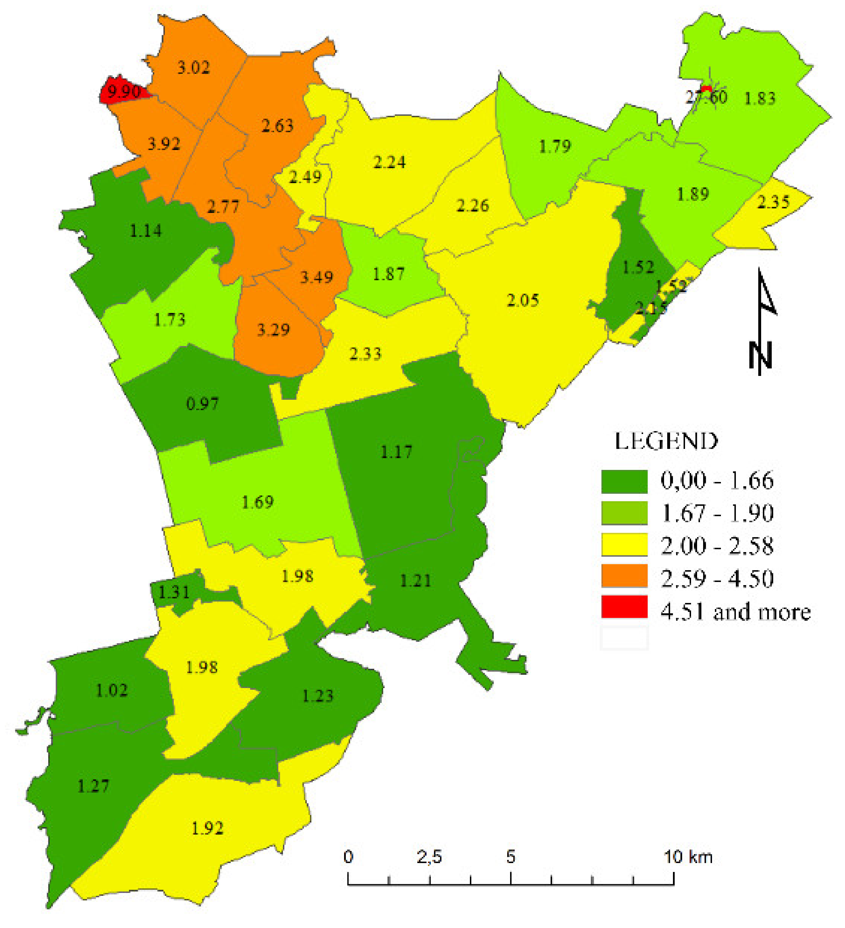
| DISTRICT | A.1 | A.2 | A.3 | A.4 | A.5 | A.6 | A.7 | A.8. | A.9 | E.1 | E.2 | E.3 | SUM | Vi | |
| j | 1 | 2 | 3 | 4 | 5 | 6 | 7 | 8. | 9 | 10 | 11 | 12 | r = 12 | ||
| i | nij wj | ||||||||||||||
| 1 | Bałdy | 0.0015 | 0.0005 | 0.0005 | 0.0004 | 0.0018 | 0.0003 | 0.0004 | 0.0013 | 0.0007 | 0.0003 | 0.0038 | 0.0008 | 0.0123 | 1.23 |
| 2 | Butryny | 0.0035 | 0.0016 | 0.0025 | 0.0023 | 0.0039 | 0.0003 | 0.0003 | 0.0009 | 0.0007 | 0.0003 | 0.0026 | 0.0010 | 0.0198 | 1.98 |
| 3 | Gąsiorowo | 0.0039 | 0.0017 | 0.0024 | 0.0022 | 0.0029 | 0.0003 | 0.0004 | 0.0009 | 0.0013 | 0.0003 | 0.0051 | 0.0022 | 0.0235 | 2.35 |
| 4 | Giławy | 0.0033 | 0.0013 | 0.0014 | 0.0013 | 0.0019 | 0.0003 | 0.0004 | 0.0011 | 0.0014 | 0.0004 | 0.0045 | 0.0015 | 0.0189 | 1.89 |
| 5 | Grabowo | 0.0811 | 0.0082 | 0.0147 | 0.0069 | 0.0000 | 0.0003 | 0.0002 | 0.0037 | 0.0022 | 0.0000 | 0.1587 | 0.0000 | 0.2760 | 27.60 |
| 6 | Groszkowo | 0.0023 | 0.0015 | 0.0013 | 0.0012 | 0.0014 | 0.0003 | 0.0003 | 0.0009 | 0.0007 | 0.0005 | 0.0025 | 0.0024 | 0.0152 | 1.52 |
| 7 | Kaborno | 0.0046 | 0.0025 | 0.0036 | 0.0033 | 0.0026 | 0.0003 | 0.0006 | 0.0016 | 0.0015 | 0.0004 | 0.0110 | 0.0011 | 0.0329 | 3.29 |
| 8 | Klebark M. | 0.0052 | 0.0033 | 0.0054 | 0.0049 | 0.0058 | 0.0003 | 0.0007 | 0.0002 | 0.0002 | 0.0002 | 0.0030 | 0.0010 | 0.0302 | 3.02 |
| 9 | Klebark W. | 0.0038 | 0.0019 | 0.0032 | 0.0030 | 0.0042 | 0.0008 | 0.0006 | 0.0007 | 0.0006 | 0.0003 | 0.0071 | 0.0001 | 0.0263 | 2.63 |
| 10 | Klewki | 0.0032 | 0.0023 | 0.0035 | 0.0032 | 0.0060 | 0.0003 | 0.0002 | 0.0004 | 0.0005 | 0.0003 | 0.0067 | 0.0011 | 0.0277 | 2.77 |
| 11 | Łajs | 0.0016 | 0.0007 | 0.0006 | 0.0006 | 0.0007 | 0.0003 | 0.0010 | 0.0013 | 0.0009 | 0.0004 | 0.0033 | 0.0007 | 0.0121 | 1.21 |
| 12 | Linowo | 0.0017 | 0.0008 | 0.0008 | 0.0007 | 0.0010 | 0.0007 | 0.0002 | 0.0007 | 0.0008 | 0.0003 | 0.0031 | 0.0007 | 0.0114 | 1.14 |
| 13 | Marcinkowo | 0.0035 | 0.0020 | 0.0032 | 0.0030 | 0.0044 | 0.0003 | 0.0005 | 0.0007 | 0.0004 | 0.0004 | 0.0040 | 0.0008 | 0.0233 | 2.33 |
| 14 | Nerwik | 0.0022 | 0.0011 | 0.0008 | 0.0008 | 0.0005 | 0.0003 | 0.0006 | 0.0018 | 0.0015 | 0.0004 | 0.0061 | 0.0021 | 0.0183 | 1.83 |
| 15 | Nowa Kal. | 0.0022 | 0.0010 | 0.0018 | 0.0016 | 0.0023 | 0.0003 | 0.0003 | 0.0006 | 0.0004 | 0.0003 | 0.0008 | 0.0010 | 0.0127 | 1.27 |
| 16 | Nowa Wieś | 0.0028 | 0.0012 | 0.0017 | 0.0016 | 0.0029 | 0.0003 | 0.0004 | 0.0011 | 0.0007 | 0.0003 | 0.0029 | 0.0010 | 0.0169 | 1.69 |
| 17 | Ostrzeszewo | 0.0123 | 0.0098 | 0.0184 | 0.0167 | 0.0350 | 0.0003 | 0.0005 | 0.0001 | 0.0000 | 0.0002 | 0.0057 | 0.0001 | 0.0990 | 9.90 |
| 18 | Pajtuny | 0.0042 | 0.0020 | 0.0025 | 0.0023 | 0.0024 | 0.0003 | 0.0005 | 0.0014 | 0.0010 | 0.0003 | 0.0048 | 0.0010 | 0.0226 | 2.26 |
| 19 | Patryki | 0.0035 | 0.0017 | 0.0022 | 0.0020 | 0.0025 | 0.0003 | 0.0004 | 0.0011 | 0.0008 | 0.0003 | 0.0065 | 0.0010 | 0.0224 | 2.24 |
| 20 | Pokrzywy | 0.0033 | 0.0011 | 0.0013 | 0.0012 | 0.0028 | 0.0003 | 0.0002 | 0.0007 | 0.0005 | 0.0002 | 0.0000 | 0.0015 | 0.0131 | 1.31 |
| 21 | Prejłowo | 0.0026 | 0.0012 | 0.0019 | 0.0017 | 0.0035 | 0.0003 | 0.0004 | 0.0006 | 0.0005 | 0.0003 | 0.0041 | 0.0009 | 0.0179 | 1.79 |
| 22 | Przykop | 0.0034 | 0.0016 | 0.0023 | 0.0021 | 0.0025 | 0.0003 | 0.0004 | 0.0007 | 0.0007 | 0.0003 | 0.0041 | 0.0014 | 0.0198 | 1.98 |
| 23 | Purda | 0.0029 | 0.0017 | 0.0021 | 0.0020 | 0.0028 | 0.0003 | 0.0004 | 0.0007 | 0.0007 | 0.0005 | 0.0048 | 0.0016 | 0.0205 | 2.05 |
| 24 | Purdka | 0.0017 | 0.0006 | 0.0006 | 0.0006 | 0.0007 | 0.0003 | 0.0006 | 0.0019 | 0.0015 | 0.0004 | 0.0017 | 0.0008 | 0.0117 | 1.17 |
| 25 | Silice | 0.0035 | 0.0021 | 0.0036 | 0.0033 | 0.0032 | 0.0003 | 0.0005 | 0.0016 | 0.0012 | 0.0003 | 0.0047 | 0.0007 | 0.0249 | 2.49 |
| 26 | Stara Kal.. | 0.0022 | 0.0008 | 0.0009 | 0.0008 | 0.0010 | 0.0003 | 0.0004 | 0.0013 | 0.0011 | 0.0003 | 0.0001 | 0.0011 | 0.0102 | 1.02 |
| 27 | Szczęsne | 0.0054 | 0.0039 | 0.0066 | 0.0060 | 0.0101 | 0.0003 | 0.0005 | 0.0003 | 0.0004 | 0.0002 | 0.0053 | 0.0002 | 0.0392 | 3.92 |
| 28 | Trękus | 0.0033 | 0.0014 | 0.0018 | 0.0017 | 0.0021 | 0.0003 | 0.0006 | 0.0011 | 0.0010 | 0.0003 | 0.0027 | 0.0011 | 0.0173 | 1.73 |
| 29 | Trękusek | 0.0039 | 0.0019 | 0.0033 | 0.0030 | 0.0162 | 0.0008 | 0.0006 | 0.0009 | 0.0006 | 0.0003 | 0.0026 | 0.0009 | 0.0349 | 3.49 |
| 30 | Wygoda | 0.0018 | 0.0006 | 0.0006 | 0.0006 | 0.0007 | 0.0003 | 0.0003 | 0.0020 | 0.0015 | 0.0004 | 0.0002 | 0.0009 | 0.0097 | 0.97 |
| 31 | Wyrandy | 0.0030 | 0.0014 | 0.0014 | 0.0013 | 0.0036 | 0.0003 | 0.0004 | 0.0010 | 0.0008 | 0.0003 | 0.0034 | 0.0019 | 0.0187 | 1.87 |
| 32 | Zaborowo | 0.0049 | 0.0018 | 0.0016 | 0.0015 | 0.0017 | 0.0003 | 0.0002 | 0.0013 | 0.0009 | 0.0004 | 0.0058 | 0.0013 | 0.0215 | 2.15 |
| 33 | Zgniłocha | 0.0027 | 0.0010 | 0.0016 | 0.0015 | 0.0013 | 0.0003 | 0.0004 | 0.0018 | 0.0011 | 0.0003 | 0.0064 | 0.0008 | 0.0192 | 1.92 |
Publisher’s Note: MDPI stays neutral with regard to jurisdictional claims in published maps and institutional affiliations. |
© 2021 by the authors. Licensee MDPI, Basel, Switzerland. This article is an open access article distributed under the terms and conditions of the Creative Commons Attribution (CC BY) license (https://creativecommons.org/licenses/by/4.0/).
Share and Cite
Cieślak, I.; Biłozor, A. An Analysis of an Area’s Vulnerability to the Emergence of Land-Use Conflicts. Land 2021, 10, 1173. https://doi.org/10.3390/land10111173
Cieślak I, Biłozor A. An Analysis of an Area’s Vulnerability to the Emergence of Land-Use Conflicts. Land. 2021; 10(11):1173. https://doi.org/10.3390/land10111173
Chicago/Turabian StyleCieślak, Iwona, and Andrzej Biłozor. 2021. "An Analysis of an Area’s Vulnerability to the Emergence of Land-Use Conflicts" Land 10, no. 11: 1173. https://doi.org/10.3390/land10111173
APA StyleCieślak, I., & Biłozor, A. (2021). An Analysis of an Area’s Vulnerability to the Emergence of Land-Use Conflicts. Land, 10(11), 1173. https://doi.org/10.3390/land10111173