Article

The Influence of Strip-City Street Network Structure on Spatial Vitality: Case Studies in Lanzhou, China

1
School of Architecture and Urban Planning, Lanzhou Jiaotong University, Lanzhou 730070, China
2
School of Traffic and Transportation, Lanzhou Jiaotong University, Lanzhou 730070, China
*
Author to whom correspondence should be addressed.
Land 2021, 10(11), 1107; https://doi.org/10.3390/land10111107
Submission received: 22 September 2021 / Revised: 17 October 2021 / Accepted: 18 October 2021 / Published: 20 October 2021
(This article belongs to the Topic Architectures, Materials and Urban Design)

Abstract

:
In the context of China’s recent urbanization, the agglomeration and diffusion of the strip-city spatial network are gradually being reconstructed. The ways in which the street network structure affects the underlying logic of economic and social development is worthy of in-depth consideration. This study takes Lanzhou (a typical strip city in China) as a case study, using dynamic, geographic, big data and spatial syntactic-theory models to explore the influence of street network accessibility and structure on the spatial and temporal distribution of strip-city spatial vitality. We use Hotspot Analysis (Getis-Ord Gi*) to analyze the dispersal characteristics of street space vitality. In addition, the spatial and temporal heterogeneity characteristics and mechanism of the influence of street accessibility on spatial vitality are evaluated using the spatial Durbin model (SDM). The results show that: the temporal and spatial performance of urban vitality on weekdays and weekends conforms to people’s daily activities, offering similar spatial agglomeration and dispersion effects; accessibility and pedestrian-friendly streets have better urban spatial vitality clustering; street network integration significantly affects the reshaping of urban vitality, but there is apparent temporal heterogeneity in the degree of impact.

1. Introduction

China has experienced nearly 40 years of rapid urbanization, attracting many people into the cities, and high-density urban space has brought unprecedented development to Chinese towns. With the rapid expansion of urban infrastructure, the road network density has increased year by year. By 2020, the road network density of 36 major cities in China will reach an average of 6.1 km/km2 [1,2]. However, the urban traffic conditions have not been improved significantly. Primarily, it is the city center that generally shows increasingly severe congestion [3] and reduced road capacity [4], and the contradiction between urban street network efficiency and vitality reshaping has become more prominent [5]. Belt-shaped cities are restricted mainly by natural conditions such as rivers and valleys [6]. Most urban streets are distributed horizontally with traffic arteries as the main skeleton, and various urban functional facilities are distributed along the central axis. The belt-shaped layout increases the organization of the inner space of the city. The difficult fragility of the urban transportation network has exacerbated the problem of reconstruction of the urban spatial network [7,8]. These factors are related to the contradiction between the city’s spatial efficiency and its vitality [9,10,11,12,13,14,15,16]. As the critical index to evaluate the sustainable development of a city, the coordination and interaction between the efficiency and vitality of the street network in city space is helpful in improving the city’s competitiveness and attraction. Discovering and understanding the order of urban spatial development, and grasping the internal operating mechanism of urban network structure characteristics are crucial to activating economic and social vitality and finding the ideal street network structure.
Spatial vitality is the degree of satisfaction related to humans’ basic movements while living and producing, and exploring their surroundings [4]. The human’s daily activity relies on the street spaces. Hence, recognizing residents’ daily spatial movement is an intense focus that needs attention, in order to rebuild human-oriented spatial vitality. Many scholars have tried to evaluate the vitality of cities via different aspects of street spaces. Thorough research has found that crowd gathering mainly relates to street type, density, variety, and traveling environment, and it complies with Jacob’s vitality framework. Moreover, many scholars have evaluated the idea that streets impact the distribution of city vitality from aspects of city features (for instance, street accessibility, landscaping, crossing, and public transportation stops), travel methods (for example, walking, shared bicycles, and taxi accessibility), and from a time point of view (such as working day, weekends, evenings, and mornings) [17,18,19,20,21].
The material space that affects urban vitality is closely related to the network structure of urban streets. The characteristics are closely related and widely recognized [22]. Moreover, the street network structure differences associated with the urban form and the level of spatial vitality are also different [23]. It is necessary to explore the reconstruction of urban space from the relationship between the urban street network structure characteristics of a specific form and the urban vitality.
The street spatial network not only functions as the carrier to the places of city public activities and pedestrian flow, having both material and social attributes, but it also posesses apparent features of adjustability and complexity. It can reveal the position of majority-component factors of a city and the limitation of population flow in the city to a large extent. This perspective has been acknowledged in articles [24]. Street accessibility can effectively measure the location advantage of urban spatial activities through intuitive, structural feature indicators [25]. The spatial vitality distribution of the nine streets in the old city of Nanjing, China, have found that efficient and convenient street accessibility is an essential condition for the formation of street vitality [18,26]. A study on the distribution of vitality in Johor Bahru and Shenzhen found that people prefer to spend their leisure time in commercial centers with high accessibility [15,27]. The travel environment is also a key factor affecting the distribution of urban vitality. According to the travel needs of urban residents, an exemplary infrastructure configuration can provide the basis for night city vitality [28]. The spatial characteristics of urban vitality at different times within a week showed that the vitality distribution has prominent spatial-cluster characteristics, especially in a bicycle travel environment. This feature will change significantly throughout the day [29] under different travel scales. Streets with convenient transportation and high accessibility are more attractive to pedestrians [30]. Under the travel characteristics of a compact city, the accessibility of public transportation services and parking facilities is significantly and positively correlated with urban spatial vitality [14]; thus, the complex network centrality of streets has a positive impact on reshaping of urban vitality [31]. Different modes of travel such as driving, cycling, and walking, show significant differences in shaping urban vitality. In addition, some studies have verified the conditions for the vitality of Jacobs’s six cities through geographic-information big data [32]. Further, it has been confirmed that the urban street network structure during travel time, aggregation scale, functional mixing degree, and appropriate traffic organization are vital factors affecting spatial vitality [33,34]. Under the background of sustainable development of the city in the future, modern planners eagerly need to utilize the city’s complicated network by profoundly analyzing the city’s spatial structure, to promote the ordered organization of the lower social–physical environment. Therefore, current research must measure street network configurations from multiple dimensions in time and space, and compare spatial vitality related to street network structures at different geographic scales.
First, the vitality of urban space usually consists of points of interest (POI), social media comments, etc., such as catering businesses and corporate offices (Yelp, Dianping, Weibo sign-in), among others [15,28,35]. The fluidity differences in the gathering and scattering of urban residents have often been neglected. Over time, the spatial vitality is consistently maintained in streets with higher levels of population concentrations, which is associated with appropriate building density and street functions [36,37]. Secondly, most studies use linear correlation analysis methods, such as the Pearson correlation coefficient, to test the relationship between street network and spatial vitality [9,38]. Spatial vitality is a typical, spatial, autocorrelation geographic event, so it is impossible to pinpoint the influence of street accessibility alone. Thirdly, the existing research on the relationship between urban-space vitality and streets has a small research scope. Most of the studies take microscopic streets or residential blocks as the research objects without considering the city’s overall spatial and temporal heterogeneity [18,26,39]. This research expands the scope of research based on previous work. It considers the lack of comparison of the vitality of workdays and weekends, and the lack of human perception in the existing research. Finally, the difference in the distribution of urban form and spatial vitality is a gap in existing research. In response to these problems, this study selects Lanzhou, a typical strip city in China, and uses Baidu heatmap data to express spatial-vitality distribution characteristics during weekdays and weekends, and constructs a street network accessibility evaluation index based on spatial syntax. Lastly, we use the spatial Durbin model to explore the relationship between urban vitality and road network accessibility under different travel times and modes, to evaluate the impact of accessibility on urban vitality.
This research contributes to the literature in the following three aspects. First of all, this research aims to measure the spatial vitality of a specific form (strip city) using geospatial dynamic big data. Secondly, this research applied Axwoman software based on space syntax theory to measure the accessibility of street network topology. Thirdly, since the existing research rarely fully considers the effects of time and space when calculating the street configuration, this study combines the time and space perspective with the street network to study the time and space correlation between the street network accessibility and structure and the spatial vitality. We hope to provide helpful information for planning and design practices, and provide references for future research.

2. Regions and Dataset

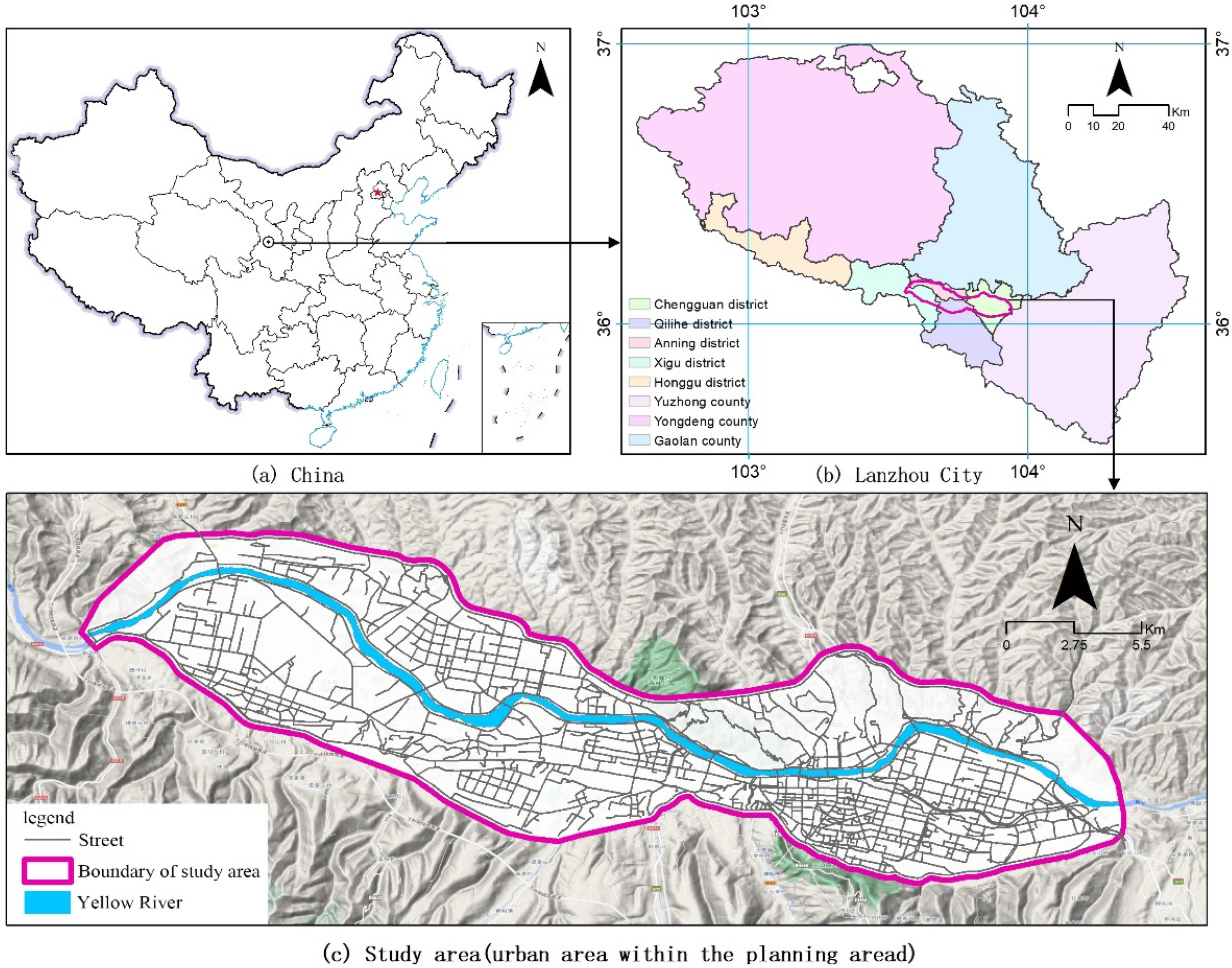
2.1. Regional Overview

Lanzhou (92°13′–108°46′ E, 32°11′–42°57′ N.) City is located in the geometric center of mainland China’s land area and the central part of Gansu Province. It is an important provincial capital city in Northwest China and a significant node city along the Silk Road Economic Belt [7]. Lanzhou has become a modern metropolis with high attractiveness and international influence as a comprehensive transportation hub for the New Eurasian Continental Bridge to open Central Asia and West Asia. Lanzhou is the most typical representative of China’s 43 prefecture-level strip cities. As shown in Figure 1, the city is located in a mountainous valley with mountains on both north and south sides. The Yellow River crosses the central city from west to east. The city’s north-to-south expansion is restricted by the mountain river valley, forming the typical strip city (Lanzhou) that grows horizontally from east to west along the Yellow River. The length is about 34 km from east to west, and the width is 7.3 km at the widest point and 2.1 km at the narrowest point from north to south, also the average length–width ratio is 7.23:1. The characteristic of the street network in the form of a strip city is that the number of vertical arterial roads is limited, and the number of horizontal connecting roads is large. The traffic flow of the perpendicular arterial roads is concentrated, and there is a particular mismatch between the limited vertical traffic resources and the considerable traffic demand. As of 2020, Lanzhou has built a skeleton road network system with 1428.68 km, essentially forming a mature street network covering the central city and also across the Yellow River.
This paper selects the built-up area in the center of Lanzhou as the study area. This area has the highest population density and urbanization in Lanzhou, with a total area of about 230.34 square kilometers. As of 2020, the permanent population is 2.676 million, and the population density is 11,600 per square kilometer.

2.2. Dataset

2.2.1. Dataset of Streets

The network data of the streets in the downtown area of Lanzhou were collected from the shapefile vector format data of the open OSM platform (https://www.openstreetmap.org/. Collected on 5 January 2020) [40]. The original street network dataset contains many details and double-line redundancy. We used ArcGIS 10.8 to convert double-line to single-line processing, interrupted urban interchanges, and eliminated internal roads in residential quarters. A total of 668 street data were obtained. Then, based on the topological isolation check of the street network data, the urban street network dataset was constructed to calculate the spatial syntax variable value.

2.2.2. Point of Interest Data

The POI dataset contains latitude, longitude, name, and address information and is a spatial abstraction of geographic entities [41]. The POI data of this study comes from Amap (https://www.amap.com/. Collected on 15 January 2020), 39,029 valid data are selected at the street level, and the specific classification is shown in Table 1. The superposition of POI and streets can accurately reflect the functional diversity of streets [5].

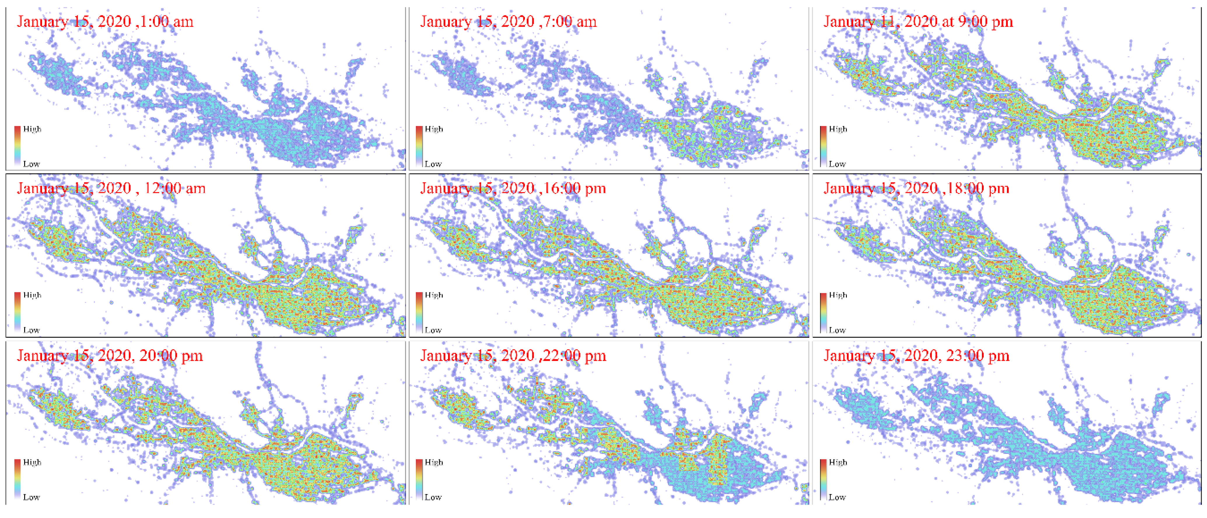
2.2.3. Baidu Heatmap Data

The Baidu heatmaps are based on the geographic data of mobile-phone users on the LBS platform, which can display the continuous time span and the changes of population aggregation in different regions. It is considered one of the most effective dynamic expressions of spatial vitality [36]. The heatmap data of this study use the open API interface called Baidu Map. We used Python programming language to build an ArcGIS model toolbox to obtain 168 heatmap raster data of the study area from 12 January to 17 January 2021, for one week, with a time interval of 1 h and a spatial resolution of 25 × 25 m. Figure 2 shows some examples of Baidu heatmaps on 15 January 2020.

3. Methods

3.1. Street Network Accessibility Evaluation

As a typical graph-theory-based analysis method, spatial syntax usually constructs an axis model and line segment model to analyze urban road structures [42,43]. This paper uses the line segment model of the Arcgis plug-in Axwoman, in order to build a city street topology network. Street intersections are represented as nodes, and road segments are represented as edges with lengths connecting the nodes [44,45]. The line segment model considers the uninterrupted section of the road as an element in the topology calculation, and considers the spatial scale for more accurate results. We use Axwoman software to calculate the Connect, Control, Depth, and aggregation values of each street to measure the accessibility structure of the street network [46].
Connect value: the better the spatial permeability of the street. The formula of Ci for street i is:
C i = k
k is the number of other elements connected to the i street element.
Control Value: indicates the degree of control of the street on the space intersected with it, reflecting the degree of control of the section on other streets, generally expressed in ctrli
c t r l i = j = 1 k 1 C j
where k is the number of direct connections to the i street; Cj is the connection value of the j street. The higher the control value, the more critical the street is.
Depth value: indicates the minimum number of connection steps for a street to reach all other streets in the street network. Assuming that the minimum number of connections is d (d is an integer, 1 ≤ ds), and the number of connected routes is Nd, the formula is:
D d = d = 1 n d × N d
When d = 1, representing the number of elements directly connected with the specified street, the depth value is a one-step depth value, namely, the depth value is equal to the Connect value;
When the step distance increases gradually, the depth value also increases gradually, and the depth value is the local depth value.
When d = s, the depth value is the TotalDepth value. The specific application of the MeanDepth value is commonly used. The formula is:
D ¯ i = D i n 1
where n is the number of streets in the network to be examined, and n1 reflects the fact that there are, at most, n1 streets connected to the specified streets in the examined dataset.
Integration value: the degree of aggregation or dispersion between a street and other street spaces in the road network. It can be divided into global integration value (GIi) and local integration value (LIi). The international degree of integration represents the topological relationship between a road and all other roads, while the local degree of integration represents the interrelationship between a road and the streets within a few steps (usually three steps) from it, which is calculated as
I i = ( n 2 ) / 2 ( D i ¯ 1 ) L I i = n [ log 2 n + 2 3 1 ] + 1 ( n 1 ) ( D i ¯ 1 ) }
For an urban travel distance, we consider that the number of steps required to traverse from the origin to the destination is related to the mode of transport. It is evident that to reach a distance of more than three steps on urban roads, the travel mode will be more inclined towards car travel, while a distance of less than three steps represents walking travel. Streets with high local integration facilitate walking when considering the accessibility of the urban road network [47], while global integration is more appropriate to explain the mobility characteristics of human driving patterns in the city [48].

3.2. Spatial Vitality Measurement

According to Jacob’s urban vitality theory [5,16], a vibrant city manifests human psychological behavior in space and the diversity generated by the interaction between human activities and metropolitan areas, including streets, diverse functions, a specific population density, and mixing of environments. We use the population-vitality Baidu heatmap data to process [49] the heat value, use the grid calculator to calculate it, and then reclassify the population heat value into 1–7 levels as the quantitative value of urban spatial vitality. To observe the spatial distribution of characteristics of urban vitality, a block vitality intensity model was constructed to calculate the urban spatial vitality intensity values (Block Vitality intensity) at different periods on weekdays and rest days. The calculation formula is:
V i n t = i = 1 n V i n
Vint represents the vitality intensity value of the block; i represents different moments, i = 1, 2, 3 ⋯, n, n is the number of moments involved in the calculation; Vi represents the heat value level of a particular spatial unit at the time i.
The vitality intensity value reflects the clustering degree of people in a certain period within a spatial unit. The larger the vitality intensity value, the higher the clustering of people in the block during the period and the stronger the vitality. The time of participation in the calculation is different, which characterizes the intensity of vitality at different periods.

3.3. Hotspot Analysis (Getis-Ord Gi*)

Getis-Ord Gi* analysis is essential for geospatial identification of statistically significant hot and cold spots [50]. It can be better applied to analyze the cluster distribution characteristics of street vitality intensity, reflect the distribution of hot and cold spots in the local space of the research object, and accurately identify high-value clusters and low-value clusters. The positive and negative Gi* statistics with high absolute values correspond to the high-value aggregation area and low-value aggregation area of spatial vitality, respectively. Negative Gi* indicates an aggregation trend with a shorter duration of vitality. Gi* values close to 0 show a random distribution of observed spatial events.

3.4. Relevance Exploration

The temporal and spatial patterns of crowd activities determine the continuity and dynamics of street vitality [51]. We focus on the influencial mechanism of street network accessibility and structure on spatial vitality changes. First, we convert the data of street network (line segment) and spatial vitality (surface) into the same analysis cell by creating a 100 m×100 m square grid network with the fishing net tool in ArcMap. A total of 23,557 spatial grid cells were obtained. Then, we utilized Global Moran’s I test to obtain the significance of autocorrelation between urban street network structure and urban-space vitality.
I = i = 1 n j = 1 n w i j ( x i x ¯ ) ( x j x ¯ ) S 2 i = 1 n j = 1 n w i j
xi and xj denote the attribute values on grid i and j geographic cells; x is the average of the attribute values in each region; wij is spatial weight matrix, indicating the proximity relationship between i and j; n is the number of measured regions; S2 is the sample variance.
Moran’s I > 0 represents a positive spatial correlation, the larger the value, the more pronounced the spatial correlation. Moran’s I < 0 indicates a negative spatial correlation, and the smaller the value, the more discrete in space. Moran’s I = 0 means that the space is random.
We also used Spearman and Kendall’s tau-b coefficients to explore the preliminary linear correlation between urban vitality and street centrality to explain the non-normal distribution of numerical variables.

3.5. Spatial Doberman Model

Linear regression analysis did not consider the spatial autocorrelation of vitality or the spatial distribution of built environment factors. It is challenging to reveal further the spatial impact of the street-built environment on urban vitality [52]. This paper uses a spatial autoregressive model to display the effect of the built environment on urban vitality. It considers the temporal and spatial impacts of urban vitality. The formula is
y = ρ W 1 y + β 1 X + μ μ = λ W 2 μ + ε ε : N ( 0 , δ 2 I ) }
where y is the dependent variable; ρ is the W1y coefficient of the spatial lag term; X is the independent variable; β is the regression coefficient of the independent variable; μ is the random error term; ε is the random error subject to a mean value of 0 and a variance of δ2; W1 and W2 are the weight matrices of the spatial trend of the dependent variable and the residual, respectively; λ is the regression coefficient of the spatial error term. According to the different parameter settings in Formula (3), three spatial autoregressive models can be generated, including the spatial lag regression model, spatial error model, and spatial Durbin model.
(1) When ρ≠0 and λ = 0, it is a spatial lag model (SLM). The spatial lag regression model considers the spatial correlation of dependent variables. In this article, this means the spatial vitality of the street is not only affected by related driving factors but also affected by the vitality of the surrounding streets, that is, considering the spatial autocorrelation of vitality.
(2) When ρ = 0 and λ ≠ 0, it is a spatial error model (SEM). The spatial error model considers the spatial correlation of fitting errors. In this article, this means that the spatial vitality of the street is not only affected by the relevant driving factors but also affected by the fitting error of the surrounding street vitality.
(3) When ρ≠0 and λ ≠ 0, it is a spatial Durbin model (SDM). The spatial Durbin model considers the spatial autocorrelation of the dependent variable and error and incorporates the independent variable’s spatial trend effect into the model. The formula is:
y = ρ W 1 y + β 1 X + λ W 2 μ + W 3 X β 2 + ε ε : N ( 0 , δ 2 I ) }
The parameters in the formula are consistent with those in Formula (3), thus W3 is the weight matrix of the spatial trend of the independent variable; β2 is the regression coefficient of this item.

4. Results

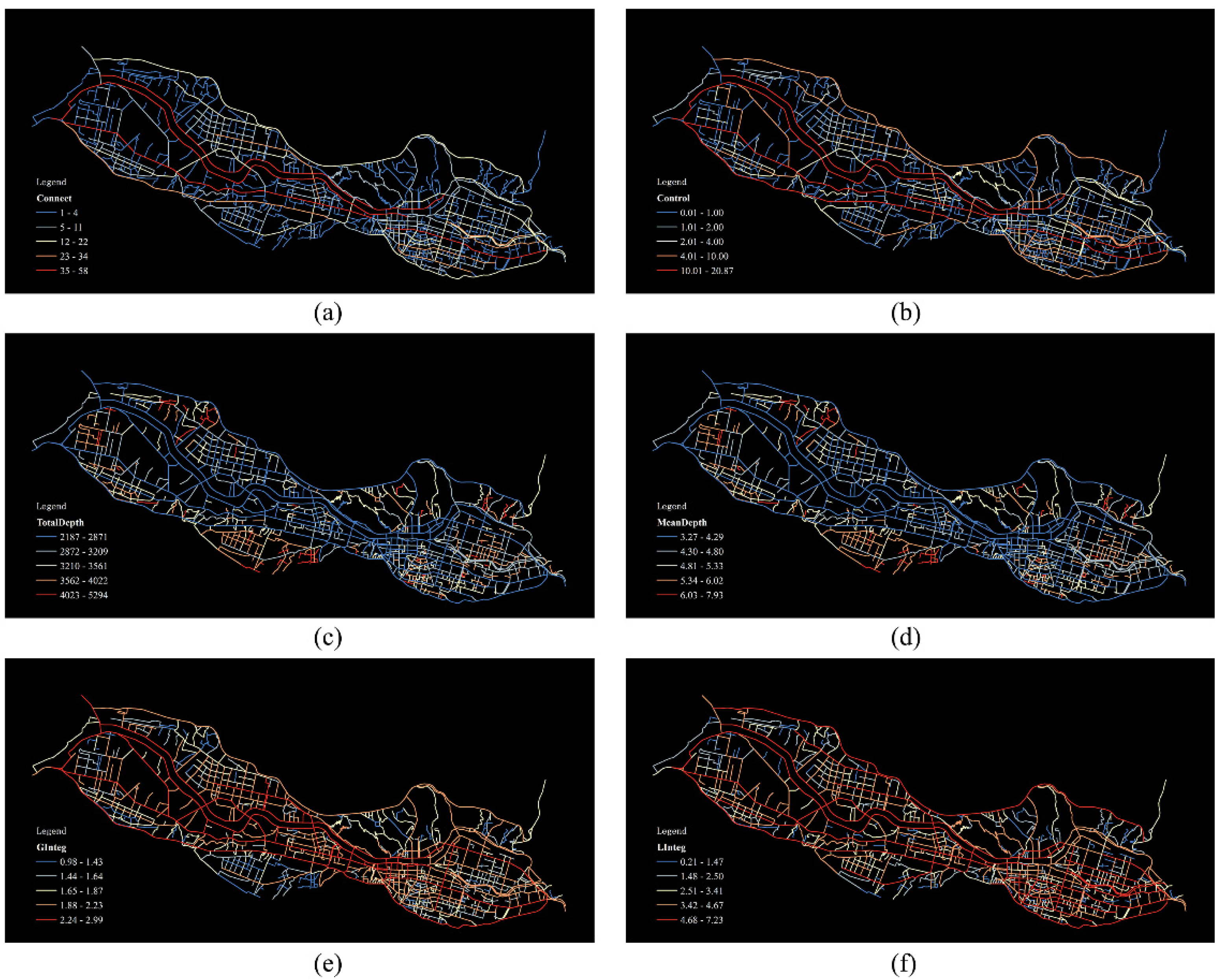
4.1. Street Network Structure Based on Space Syntax

In this paper, the Axwoman software is used to calculate the accessibility index of each street, as shown in Figure 3.
Table 2 shows the network structure index statistics of Lanzhou streets based on spatial syntax. The Connect value reflects the number of connections between the street space and other adjacent streets. The higher the Connect value, the better the spatial permeability of the street. The street with the largest Connect value, Xijin Road, is connected with 58 other streets and is the leading traffic road connecting the east–west direction of Lanzhou City. The standard deviation of the Connect value is 5.17. The control value indicates the degree of control of the street to the intersecting space; the maximum value is 20.88, the minimum value is 0.02, and the standard deviation is 1.72. The higher the control value, the more critical the street is. The depth value represents the minimum number of connected steps for a road in the street network to reach all other roads. The calculated standard deviations of the TotalDepth value and the MeanDepth value are 462.09 and 0.69, respectively. The standard deviation of the TotalDepth value is too large and does not have statistics. The academic value is eliminated, and the MeanDepth value is used as the practical value. The integration value reflects the degree of aggregation or dispersion between a particular road and other roads in the road network. The higher the integration degree, the better the accessibility of the road section. The global integration degree (GInteg) represents the topological relationship between a road and all other roads. However, the local integration degree (LInteg) describes the relationship between a particular road and the road within a few steps (usually three steps) away from it. The standard deviations are 0.31 and 1.16, respectively.

4.2. Temporal and Spatial Distribution Characteristics of Spatial Vitality

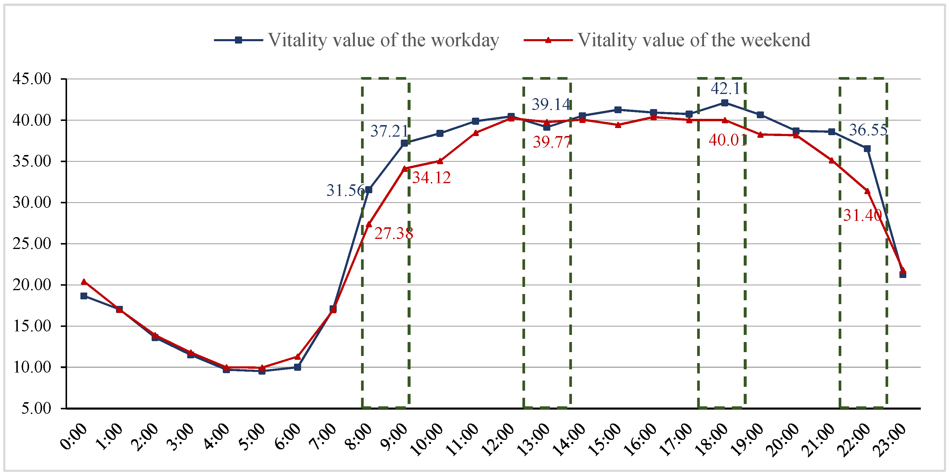
4.2.1. Temporal Characteristics of Spatial Vitality

Figure 3 shows the temporal characteristics of spatial vitality. The changing trend of urban vitality is in line with the rhythm of daily human life. The vitality value rises sharply during the morning peak time and significantly decreases during sleep time. Vitality gathers into a high-value gathering trend. Whether on weekdays or weekends, the city begins to wake up after 7:00 in the morning, and the city’s vitality drops significantly after 22:00, and people start to stop outdoor activities. On weekdays, during the commute time from 8:00 to 9:00 in the morning, the vitality builds up and remains stable, forming the first wave of spatial vitality around noon. It can be inferred that in the morning, as people commute from home to work, the degree of population concentration increases rapidly, reaching the first peak of workday gathering, which is coordinated with the commuting schedule of workdays.
At 1:00 pm, the vitality dropped slightly and formed a trough. It is inferred that part of the population return home during the lunch break, resulting in a decline in population concentration. At 3:00 pm and 6:00 pm, there are two peaks of population gathering, and at 6:00 pm, the peak of workday gathering is formed, and it drops rapidly in a short time, as people return home. After 7:00 am on weekends, the degree of vitality gradually increased, and the overall vitality was slightly lower than that of working days, reaching a peak at noon and approaching working days, indicating that people have more free time at their disposal on weekends. There are apparent fluctuations until 6:00 pm when the vitality of the population gathering gradually decreases, and there is a small peak of vitality at 8:00 pm showing the city’s night vitality.
By comparing the temporal characteristics of urban spatial vitality on working days and nonworking days (Figure 4), we find that:
  • On weekdays and weekends, based on spatial vitality, the concentration of vitality during the day is significantly greater than that at night. This is in line with common sense that the concentration of people in residential areas is lower than that of areas with public activities, thus providing the facial validity of our research results.
  • Regarding the degree of population concentration, the vitality value of the city center during workdays is generally higher than that on weekends, and the crowd on workdays is more concentrated than on weekends. After 11:00 pm, the trend of gathering vitality on weekends is higher than that on weekdays. The vitality of streets at night mainly comes from weekend activities.
  • Comparing the volatility of the vitality aggregation curve, the volatility of most working days is greater than that of the weekend, which is related to urban commuting. Comparing the curvature of the morning and afternoon curves shows that people gather and disperse faster on weekdays than on weekends.

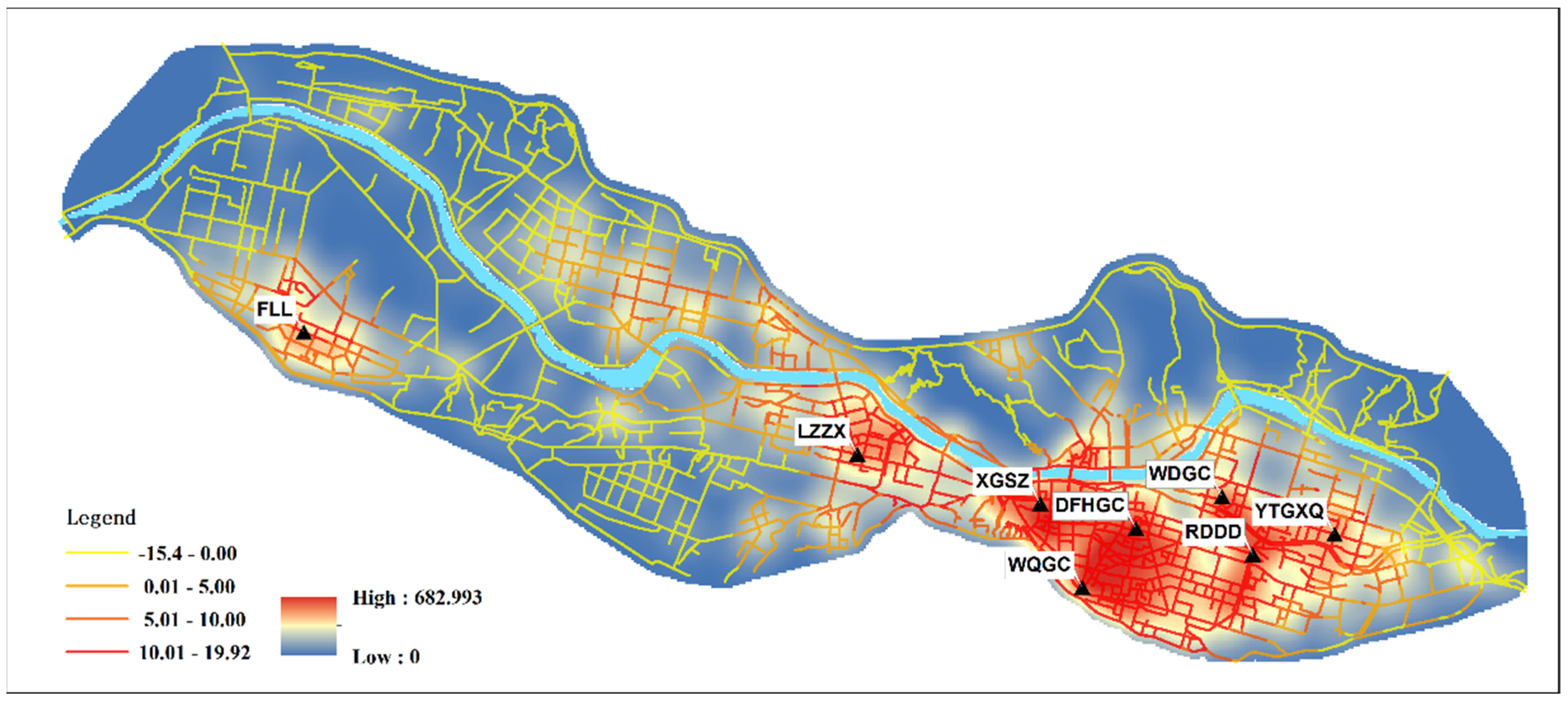
4.2.2. Spatial Characteristics of Urban Vitality

The statistics of Hotspot Analysis (Getis-Ord Gi*) are used to identify the statistically significant spatial-vitality clusters in the two time periods of weekdays and weekends. The classification of high clusters and low clusters uses the average value of street spatial vitality. Cool and warm colors are used to indicate the degree of vitality gathering, where warmer colors indicate higher vitality gathering.
As shown in Figure 5, the spatial distribution of urban vitality in the study area is highly consistent with the gathering features on weekdays and weekends, and the spatial distribution is highly uneven. Superimposed comparison with POI core density shows that the streets with a high concentration of vitality in the main urban area are mainly concentrated in shopping malls, commercial office areas, leisure and entertainment areas in Chengguan District (such as Dongfang Hong Square, Wuquan Square, Ruide Avenue, Wanda Mall, and Yan Tan High-Tech Zone), Lanzhou Center, Xiguan Cross, etc., squares and shopping malls in Qilihe District, and commercial areas and parks in Xigu District. Anning District, the main university gathering area, is not a prominent gathering vitality area. It is worth noting that obvious gathering vitality is created on both sides of the urban traffic beehive belt in Qilihe District and Chengguan District, while the beehive itself forms a cold zone, and the heavy traffic and busy streets are not conducive to the formation and gathering of vitality. Through the clustering of hotspots, it is found that the urban areas with high urban vitality in Lanzhou are distributed in a “multi-center cluster”, mainly close to the intersections of the main streets. In addition, the streets along the Yellow River are connected through bridges and streets with high levels of vitality form vitality clusters that cross the river. However, most river-crossing areas are limited by the number and scale of bridges and other connections, and they do not provide any high vitality clustering areas. The blocking effect of the river on the urban spatial vitality distribution is noticeable. It is inferred from this that good traffic accessibility is conducive to the formation and gathering of vitality around street facilities.
To explore the influence of street network functions on the distribution of urban vitality, we conducted regression analysis on the urban vitality on weekdays and weekends and the vitality of POI (points of interest) facilities, in order to reveal the impact of street-function accessibility on spatial vitality. Because of the mixed nature of each street type, we regard the POI facility type with the most significant cumulative number as the primary street-function type. There are apparent differences in the intensity of the influence of various street function elements on city vitality on weekdays and weekends. When considering street accessibility under the characteristics of working day trips, the top five rankings are: shopping services (0.2572) > company businesses (0.2356) > catering services (0.2084) > life services (0.1754) > transportation services (0.1689). When considering street accessibility under weekend travel characteristics, the top five rankings are: shopping services (0.2338) > catering services (0.1976) > corporate businesses (0.1855) > life services (0.1792) > leisure and entertainment (0.1754). The results show that shopping, employment, services, and traffic factors are essential variables for street accessibility. They affect the spatial distribution of urban vitality to a large extent. In contrast, educational facilities (schools/universities), residential areas (houses/apartments), and accommodation service facilities (hotels) have relatively little impact on urban vitality.

4.3. Correlation Analysis of Street Accessibility and Spatial Vitality

The Baidu heat value of urban spatial vitality is a quantitative variable, and the street network accessibility index is a categorical continuous variable. This article analyzes two sets of variables. The global Moran index tests the index, and the values are 0.663, 0.675, 0.826, 0.821, and 0.735, which are all greater than 0, indicating that the accessibility of the urban street network structure has the characteristics of aggregation correlation with the level of urban vitality. Through the p-value test, both are found to be significant at the 0.001 level and pass the hypothesis test. Therefore, the accessibility of the street network structure can affect the distribution of spatial vitality to a certain extent. In terms of the existence of urban spatial vitality hotspots, there is a significant difference between street grid units with high accessibility and street grid units with low accessibility [26]. At different times, streets with increased accessibility and network units with high urban vitality appear simultaneously in space.
Although the Moran Index test reflects the correlation between urban spatial vitality and street network accessibility, it cannot quantitatively explain its correlation from a statistical point of view. We need further statistical analysis to reflect the relationship between urban spatial vitality and street accessibility. The correlations between the results are shown in Table 3. The correlation coefficients of Pearson, tau-b, and Spearman show consistent directions and similar amplitudes. The five street network accessibility indexes are significantly correlated with urban vitality at the 0.05 level, and the MeanDepth value is significantly negatively associated with spatial vitality. Specifically, for street accessibility under the characteristics of urban working days, the positive correlation between integration degree and spatial vitality is the most significant, followed by the Connect value and Control value, and the average depth is significantly negatively correlated with spatial vitality. On weekends, integration and Connect values are positively associated with spatial vitality, while MeanDepth values and Control values negatively correlate with urban vitality. The correlation of the Control value under the correlation test at different periods is inconsistent, and the maximum absolute value of the correlation coefficient is only 0.125, indicating that the Control value does not have a significant effect on the distribution of spatial vitality, but people are more affected by the travel demand at different periods.

4.4. The Influencing Mechanism of Street Accessibility on Space Vitality

To obtain a more reliable estimate of the significance and direction of the impact of street network accessibility on urban vitality, we conducted a further spatial autoregressive analysis. Ordinary Least Squares (OLS) is a classic regression model, but it cannot solve the spatial autocorrelation effect [29]. Therefore, spatial autoregressive model analysis is used to fill this deficiency. To better compare the results of different spatial autoregressive models, we use the spatial Durbin model (SDM), spatial lag model (SLM), and spatial error model (SEM) for analysis. Considering the characteristics of the horizontal distribution of the strip-city street network along the main roads, and the influence of street accessibility under different travel time environments on the spatial vitality [8], we carried out two sets of variable spatial regression analyses on weekdays and weekends, respectively. Table 4 and Table 5, respectively show the spatial relationships between street network accessibility and urban vitality distribution during weekdays and weekends. The model’s variance expansion coefficient was verified, and the largest variance expansion factor (VIF) of all parameters was 4.95, which was within the acceptable range, and there was no serious multicollinearity. According to the Log-likelihood function value of the variable index, Akaike information criterion and R2 comparison, it was found that for the likelihood function value and R2, the higher the value, the better the performance; for the Akaike information criterion, the lower the value, the better the performance. What is essential is that the components of the urban street network are organically connected, and the street accessibility of a block is likely to be related to the street network of its neighboring blocks. In view of the potential exogenous and endogenous spatial interaction effects, the comparison of the log-likelihood function values and R2, and the results of the robust Lagrangian multiplier test, prove that SDM is more suitable for our research.

4.4.1. Overall Spatial Effect

Table 4 and Table 5 show the analysis results of the influence of street network accessibility and structure on spatial vitality intensity during weekdays and weekends. The R2 of the four models are all high, and the constants of the two periods are 0.9053 and 0.9231, respectively, showing a clear positive correlation, indicating that streets with high connectivity have a positive impact on the vitality of the city. From the well-fitted spatial Durbin model (SDM) analysis, there are differences in the main factors affecting the vitality of the street accessibility index. The Connect value and the LInteg value have influence coefficients of 0.1423 and 0.0191 on weekdays and weekends. They are significantly positively correlated, with 0.1409 and 0.0125 at the 0.05 level, indicating that street intersections and pedestrian-friendly streets positively impact urban vitality. The two indexes of Control value and MeanDepth value are significantly negatively correlated with urban vitality at the 0.05 level, and the influence coefficients are 0.1514, 0.1264 and 0.1446, 0.1562, respectively. It can be inferred that the main roads in cities with a high degree of control over the surrounding streets are more dependent on pedestrians. Vehicles, bicycles, and other means of transportation cross these streets and do not stay for a long time, proving that streets with insufficient travel convenience are not conducive to urban formation and continuation of urban vitality [14]. The above results show that other streets connected to the street itself impact the vitality of the city. The magnitude of the impact is significantly positively correlated with street network connectivity and pedestrian-friendly streets, and significantly negatively correlated with controlled traffic streets.

4.4.2. Temporal Heterogeneity Effect

Looking at the longitudinal comparison of SDM regression results in Table 4 and Table 5, the general results of the Connect value, Control value, MeanDepth value, and local integration value of urban street accessibility have similar correlation results on weekdays and weekends. Among them, traffic streets with high Control values have higher transfer steps. Highstreets are not conducive to the gathering of vitality, showing a consistent negative correlation. The relationship between the GInteg and city vitality in the two time periods of weekdays and weekends is manifested as temporal heterogeneity. It is mainly reflected in the positive correlation of the GInteg on weekdays, with a correlation value of −0.1476, and a weekend correlation of 0.2252. This is significant at the 0.05 level, further verifying that the temporal and spatial distribution of urban vitality is related to the accessibility of the street network and is closely related to residents’ travel. Secondly, there is a slight difference in the size of the β coefficient of the SDM model on weekdays and weekends. The travel scale of the overall street network is more densely distributed on weekdays than on weekends, indicating that street accessibility structure and leisure time have a greater impact on urban vitality. People who commute are more inclined to work nearby to avoid long-distance traffic travel. The global accessibility of the city is more likely to affect the gathering of urban vitality.
We deconstructed the urban vitality duration of weekdays and weekends (9:00 am to 6:00 pm) into a regression of accessibility indicators during peak hours within a day, and the results are consistent with existing studies [34,36]. Nevertheless, we can observe more detailed changes in the relationship between street network accessibility and urban spatial vitality at different times in a day. The city is composed of interactions that flow through a network of streets. The degree of influence in different periods reveals the potential interaction between street accessibility and population flow, which is worthy of further exploration. In addition, this article does not clearly distinguish the values in walking and vehicle travel environments. Furthermore, it only indicates the GInteg and the LInteg.

5. Discussion and Conclusions

Urban streets are public open areas. They function as transportation facilitators for society and provide spaces for civilians’ daily activities, such as recreation, exercise, communication, and information exchanging. This research explores reshaping the network structure and spatial vitality of strip-city streets. This study is based on human street space. It is assumed that the built environment of the street can attract people to the street to a certain extent. At the street level, it can meet citizens’ social and economic needs such as communication, shopping, walking, and entertainment. We used heatmaps to explore the temporal and spatial distribution characteristics of urban population vitality. Secondly, based on tests of correlation between street-network structure and accessibility and the spatial vitality of Lanzhou, a typical strip city, it is determined that street accessibility can affect urban vitality. Finally, the spatial Durbin model is used to evaluate the mechanism and direction of the influence of street accessibility indicators on urban vitality. We provide a theoretical basis and guidance for the optimization of the strip-city street structure.
The main findings of this study can be summarized as follows:
  • The temporal distribution of urban vitality is consistent with the law of crowd activities, showing highly similar spatial aggregation and dispersion, and the spatial distribution of vitality mostly coincides with the location of street intersections.
  • At the level of urban spatial neighborhoods, the better the connectivity of the street network, the more vibrantly the city gathers. For streets with high controllability, and with more transfer steps, the more scattered the urban vitality is. Certain factors, for instance shopping and services in the spatial dimension, have influenced urban vitality to a large extent.
  • According to travel habits on weekdays and weekends, the GInteg and LInteg are significantly related to urban vitality, but there is a temporal heterogeneity effect.
This research has significance for policymaking, as the network configuration of related streets plays a crucial role in city distribution. The accessibility of the city is related to the distribution of the city’s spatial vitality. It also reflects that the characteristic of population aggregation of citizens’ travelling on working days and weekends is essential to scientific city planning. City planners and city administrators can conduct environmental design by using the advantages of accessibility of the street network, leading strip-city gathering from single-center to multicenter. Further, according to the pattern of population aggregation and distribution, increasing the density of branchways and alleys, applying sidewalks or bike routes to streets, and utilizing the bus-stop and parking-facility layouts are effective measures to promote street accessibility and vitality. This research also provides a new exploration idea and rational basis for quantitative optimization of constructing the urban “narrow roads and dense road network” structure.
Although this study has stated the influence and relationship between the accessibility structure and spatial vitality of the street network of a strip city, some limitations need to be addressed subsequently. First, this article used the space syntax description to describe the accessibility of the street topology network, which is feasible at a macro level. In contrast, there is a gap between the simplified street network and the existing street network, and less consideration is given to travel direction, meaning there is a certain tolerance for the spatial movement of people. Secondly, for the built environment factors, this research only considered the street-related material environment. Other factors also affect the spatial vitality, for instance, the city square which draws crowds, the accessibility of public service areas and presence of green land. Future research can use big data, such as Weibo signing-in, street-view images, and night lighting to resolve this problem. Furthermore, the complexity of characteristics of the street network can finely depict the geometric details of the street network. In the meantime, revealing the relationships between the street configuration and spatial vitality is worth studying further.

Author Contributions

Writing and editing, X.L. and X.W.; conceptualization, X.L., Y.Q. and J.Z.; methodology, J.Z. and X.W.; funding acquisition, Y.Q., J.Z. and X.G. All authors have read and agreed to the published version of the manuscript.

Funding

This research was funded by the National Social Science Foundation of China, grant number 15BJY037 and 14CJY052, “Double-First Class” Major Research Programs, Educational Department of Gansu Province, grant number GSSYLXM-04, Gansu Province Key R&D Program-Industry, grant number 21YF5GA052, 2021 Gansu Higher Education Industry Support Plan, grant number 2021CYZC-60, and Lanzhou Jiaotong University—Tianjin University Joint Innovation Fund project, grant number 2021057.

Data Availability Statement

The data that support the findings of this study are available from the corresponding author upon reasonable request.

Acknowledgments

The authors would like to thank all the editor and anonymous reviewers for their valuable insights and suggestions.

Conflicts of Interest

The authors declare no conflict of interest.

References

  1. Zhao, P. Sustainable urban expansion and transportation in a growing megacity: Consequences of urban sprawl for mobility on the urban fringe of Beijing. Habitat Int. 2010, 34, 236–243. [Google Scholar] [CrossRef]
  2. Shi, G.; Shan, J.; Ding, L.; Ye, P.; Li, Y.; Jiang, N. Urban road network expansion and its driving variables: A case study of Nanjing City. Int. J. Environ. Res. Public Health 2019, 16, 2318. [Google Scholar] [CrossRef] [PubMed] [Green Version]
  3. Tang, T.Q.; Shi, W.F.; Yang, X.B.; Wang, Y.P.; Lu, G.Q. A macro traffic flow model accounting for road capacity and reliability analysis. Phys. A Stat. Mech. Its Appl. 2013, 392, 6300–6306. [Google Scholar] [CrossRef]
  4. Barton, H.; Grant, M.; Guise, R. Shaping Neighbourhoods: A Guide for Health, Sustainability and Vitality; Taylor & Francis: London, UK, 2003. [Google Scholar]
  5. Montgomery, J. Making a city: Urbanity, vitality and urban design. J. Urban Des. 1998, 3, 93–116. [Google Scholar] [CrossRef]
  6. Qian, Y.S.; Wang, M.; Kang, H.X.; Zeng, J.W.; Liu, Y.F. Study on the road network connectivity reliability of valley city based on complex network. Math. Probl. Eng. 2012, 2012, 430785. [Google Scholar] [CrossRef] [Green Version]
  7. Teng, L.; Yang, Y. The study on the traffic problems of valley-city—A case study of Lanzhou City. Econ. Geogr. 2002, 22, 72–75. [Google Scholar]
  8. Jacobs, A.B. Great Streets; The MIT Press: Cambridge, MA, USA, 1993; ISBN 9780262100489. [Google Scholar]
  9. Fang, C.; He, S.; Wang, L. Spatial Characterization of Urban Vitality and the Association With Various Street Network Metrics From the Multi-Scalar Perspective. Front. Public Health 2021, 9, 677910. [Google Scholar] [CrossRef]
  10. Guo, X.; Chen, H.; Yang, X. An Evaluation of Street Dynamic Vitality and Its Influential Factors Based on Multi-Source Big Data. ISPRS Int. J. Geo-Inf. 2021, 10, 143. [Google Scholar] [CrossRef]
  11. Fuentes, L.; Miralles-Guasch, C.; Truffello, R.; Delclòs-Alió, X.; Flores, M.; Rodríguez, S. Santiago de Chile through the eyes of Jane Jacobs. Analysis of the conditions for urban vitality in a Latin American metropolis. Land 2020, 9, 498. [Google Scholar] [CrossRef]
  12. Cafuta, M.R. Open Space Evaluation Methodology and Three Dimensional Evaluation Model as a Base for Sustainable Development Tracking. Sustainability 2015, 7, 13690–13712. [Google Scholar] [CrossRef] [Green Version]
  13. Liu, S.; Zhang, L.; Long, Y.; Long, Y.; Xu, M. A New Urban Vitality Analysis and Evaluation Framework Based on Human Activity Modeling Using Multi-Source Big Data. ISPRS Int. J. Geo-Inf. 2020, 9, 617. [Google Scholar] [CrossRef]
  14. Bardhan, R.; Kurisu, K.; Hanaki, K. Does compact urban forms relate to good quality of life in high density cities of India? Case of Kolkata. Cities 2015, 48, 55–65. [Google Scholar] [CrossRef]
  15. Ye, Y.; Li, D.; Liu, X. How block density and typology affect urban vitality: An exploratory analysis in Shenzhen, China. Urban Geogr. 2018, 39, 631–652. [Google Scholar] [CrossRef]
  16. Jacobs, J. The Death and Life of Great American Cities, 1st ed.; Vintage Books: New York, NY, USA, 1961. [Google Scholar]
  17. Dong, Y.-H.; Peng, F.-L.; Guo, T.-F. Quantitative assessment method on urban vitality of metro-led underground space based on multi-source data: A case study of Shanghai Inner Ring area. Tunn. Undergr. Space Technol. 2021, 116, 104108. [Google Scholar] [CrossRef]
  18. Xu, X.; Xu, X.; Guan, P.; Ren, Y.; Wang, W.; Xu, N. The cause and evolution of urban street vitality under the time dimension: Nine cases of streets in Nanjing City, China. Sustainability 2018, 10, 2797. [Google Scholar] [CrossRef] [Green Version]
  19. Zeng, J.; Qian, Y.; Ren, Z.; Xu, D.; Wei, X. Road Landscape Morphology of Valley City Blocks under the Concept of “Open Block”—Taking Lanzhou City as an Example. Sustainability 2019, 11, 6258. [Google Scholar] [CrossRef] [Green Version]
  20. Zakerhaghighi, K. Urban vitality evaluation in vali asr crossroad on the basis of activity patterns. Bagh-E Nazar 2019, 16, 5–18. [Google Scholar]
  21. Yang, Y.; Ma, Y.; Jiao, H. Exploring the Correlation between Block Vitality and Block Environment Based on Multisource Big Data: Taking Wuhan City as an Example. Land 2021, 10, 984. [Google Scholar] [CrossRef]
  22. Lunecke, M.G.H.; Mora, R. The layered city: Pedestrian networks in downtown Santiago and their impact on urban vitality. J. Urban Des. 2018, 23, 336–353. [Google Scholar] [CrossRef]
  23. Oliveira, V. Morpho: A methodology for assessing urban form. Urban Morphol. 2013, 17, 21–33. [Google Scholar]
  24. Yue, H.; Zhu, X.; Ye, X.; Hu, T.; Kudva, S. Modelling the effects of street permeability on burglary in Wuhan, China. Appl. Geogr. 2018, 98, 177–183. [Google Scholar] [CrossRef]
  25. Rui, Y.K.; Ban, Y.F. Exploring the relationship between street centrality and land use in Stockholm. Int. J. Geogr. Inf. Sci. 2014, 28, 1425–1438. [Google Scholar] [CrossRef]
  26. Huajian, H. Influence of Street Traffic Accessibility on Street Vitality: A Case Study of Some Life Service Streets in Nanchang City. J. Landsc. Res. 2020, 12, 114–116. [Google Scholar]
  27. Rastegar, N.; Ahmadi, M.; Malek, M. Factors affecting the vitality of streets in downtown Johor Bahru city. Indian J. Sci. Res. 2014, 7, 361–374. [Google Scholar]
  28. Samadi, R.; Khakpour, B.A.; Rahnama, M.R.; Kharazmi, O.A. Planning and preparing strategies for the realization of night city in Mashhad metropolis, with emphasis on urban vitality indicators. Geogr. Plan. Space 2020, in press. [Google Scholar]
  29. Zeng, P.; Wei, M.; Liu, X. Investigating the spatiotemporal dynamics of urban vitality using bicycle-sharing data. Sustainability 2020, 12, 1714. [Google Scholar] [CrossRef] [Green Version]
  30. Kang, C.-D. Measuring the effects of street network configurations on walking in Seoul, Korea. Cities 2017, 71, 30–40. [Google Scholar] [CrossRef]
  31. Yue, H.; Zhu, X. Exploring the relationship between urban vitality and street centrality based on social network review data in Wuhan, China. Sustainability 2019, 11, 4356. [Google Scholar] [CrossRef] [Green Version]
  32. Sung, H.; Lee, S. Residential built environment and walking activity: Empirical evidence of Jane Jacobs’ urban vitality. Transp. Res. D Transp. Environ. 2015, 41, 318–329. [Google Scholar] [CrossRef]
  33. Kang, C.; Fan, D.; Jiao, H. Validating activity, time, and space diversity as essential components of urban vitality. Environ. Plan. B Urban Anal. City Sci. 2021, 48, 1180–1197. [Google Scholar] [CrossRef]
  34. Yu, Y.; Zhuang, Y. A Hypothesis of Urban Morphogenesis and Urban Vitality in Newly Built-up Areas: Analyses Based on Street Accessibility, Building Density and Functional Mixture. Urban Plan. Int. 2017, 32, 43–49. [Google Scholar] [CrossRef]
  35. Jin, X.; Long, Y.; Sun, W.; Lu, Y.; Yang, X.; Tang, J. Evaluating cities’ vitality and identifying ghost cities in China with emerging geographical data. Cities 2017, 63, 98–109. [Google Scholar] [CrossRef]
  36. Shi, P.; Xiao, Y.; Zhan, Q. A Study on Spatial and Temporal Aggregation Patterns of Urban Population in Wuhan City based on Baidu Heatmap and POI Data. Int. Rev. Spat. Plan. Sustain. Dev. 2020, 8, 101–121. [Google Scholar]
  37. Feng, D.; Tu, L.; Sun, Z. Research on Population Spatiotemporal Aggregation Characteristics of a Small City: A Case Study on Shehong County Based on Baidu Heat Maps. Sustainability 2019, 11, 6276. [Google Scholar] [CrossRef] [Green Version]
  38. Porta, S.; Strano, E.; Iacoviello, V.; Messora, R.; Latora, V.; Cardillo, A.; Wang, F.; Scellato, S. Street centrality and densities of retail and services in Bologna, Italy. Environ. Plan. B Plan. Des. 2009, 36, 450–465. [Google Scholar] [CrossRef] [Green Version]
  39. Jalaladdini, S.; Oktay, D. Interrogating vitality of the streets in two Cypriot Towns. Asian J. Environ. -Behav. Stud. 2018, 3, 119–127. [Google Scholar] [CrossRef]
  40. Haklay, M. How good is volunteered geographical information? A comparative study of Open Street Map and Ordnance Survey datasets. Environ. Plan. B: Plan. Des. 2010, 37, 682–703. [Google Scholar] [CrossRef] [Green Version]
  41. Batty, M. Big data, smart cities and city planning. Dialogues Hum. Geogr. 2013, 3, 274–279. [Google Scholar] [CrossRef]
  42. Hillier, B. Space Is the Machine: A Configurational Theory of Architecture; Space Syntax, UCL: London, UK, 2007. [Google Scholar]
  43. Turner, A. From axial to road-centre lines: A new representation for space syntax and a new model of route choice for transport network analysis. Environ. Plan. B Plan. Des. 2007, 34, 539–555. [Google Scholar] [CrossRef] [Green Version]
  44. Jiang, B. Ranking spaces for predicting human movement in an urban environment. Int. J. Geogr. Inf. Sci. 2009, 23, 823–837. [Google Scholar] [CrossRef] [Green Version]
  45. Sun, X. Tutorial for automatically generating axial lines. Department of Technology and Built Environment, Division of Geomatics University of Gävle. Available online: http://giscience.hig.se/binjiang/Axwoman/Tutorial4AutoGeneratingAxiallines10PDF.pdf (accessed on 20 September 2021).
  46. Jiang, B. Living structure down to earth and up to heaven: Christopher Alexander. Urban Sci. 2019, 3, 96. [Google Scholar] [CrossRef] [Green Version]
  47. Koohsari, M.J.; Sugiyama, T.; Mavoa, S.; Villanueva, K.; Badland, H.; Giles-Corti, B.; Owen, N. Street network measures and adults’ walking for transport: Application of space syntax. Health Place 2016, 38, 89–95. [Google Scholar] [CrossRef] [PubMed]
  48. Sharmin, S.; Kamruzzaman, M. Meta-analysis of the relationships between space syntax measures and pedestrian movement. Transp. Rev. 2018, 38, 524–550. [Google Scholar] [CrossRef]
  49. Zhou, Y. Spatial-Temporal Dynamics of Population Aggregation during the Spring Festival Based on Baidu Heatmap in Central Area of Chengdu City, China. Mod. Appl. Sci. 2020, 14. [Google Scholar] [CrossRef] [Green Version]
  50. Manepalli, U.R.R.; Bham, G.H.; Kandada, S. Evaluation of hotspots identification using kernel density estimation (K) and Getis-Ord (Gi*) on I-630. In Proceedings of the 3rd International Conference on Road Safety and Simulation, Indianapolis, IN, USA, 14–16 September 2011; pp. 14–16. [Google Scholar]
  51. Wu, C.; Ye, X.; Ren, F.; Du, Q. Check-in behaviour and spatio-temporal vibrancy: An exploratory analysis in Shenzhen, China. Cities 2018, 77, 104–116. [Google Scholar] [CrossRef]
  52. Xia, C.; Zhang, A.; Yeh, A.G.O. The Varying Relationships between Multidimensional Urban Form and Urban Vitality in Chinese Megacities: Insights from a Comparative Analysis. Ann. Am. Assoc. Geogr. 2021, 1–26. [Google Scholar] [CrossRef]
Figure 1. Location of the study area.
Land 10 01107 g001
Figure 2. Baidu heatmaps of the study area.
Land 10 01107 g002
Figure 3. Street network accessibility metrics calculated by Axwoman. (a) Connect, (b) Control, (c) TotalDepth, (d) MeanDepth, (e) GInteg, (f) LInteg.
Land 10 01107 g003
Figure 4. Characteristics of the Temporal Distribution of Spatial Vitality.
Land 10 01107 g004
Figure 5. Spatial Distribution Characteristics of Vitality. Note: FLL = Fuli Road, LZZX = Lanzhou Center, XGSZ = Xiguan Cross, DFHGC = Dongfang Hong Square, WQGC = Wuquan Square, RDDD = Ruide Avenue, WDGC = Wanda Mall, YTGXQ = Yan Tan High-Tech Zone.
Land 10 01107 g005
Table 1. POI Types and Numbers.
CategoryType DescriptionCounting
HealthcareHospitals/Healthcare services/Clinics/Accessible facilities2331
RecreationSports and leisure services /Tourist attractions/Cultural facilities/Place name and address information2729
Life ServicesLiving Services/Car Sales/Public Facilities/Indoor Facilities/Gazette and Address Information3055
Company BusinessOffice facilities/Place name and address information3280
Transportation ServicesTransportation facilities and services/Subway stations/Bus stops/Place name address information2254
Car ServiceAuto repair/Parking/Place name address information2545
Financial ServicesFinancial and insurance services/Security facilities1929
Catering ServicesCatering Services3188
Shopping ServiceShopping services/Car or motorcycle sales/Access to facilities/Place name and address information13,800
Accommodation ServicesLodging Services/Hotels1896
Educational FacilitiesElementary School/High School/University/Other Schools128
Residential areasBusiness Residence/Apartments1894
Table 2. Statistics Table of Street Network Structure Accessibility Index.
NMAXAVGMIXS.DANOV
Connect66858.004.041.005.1726.73
Control66820.881.000.021.722.96
TotalDepth6685294.003337.732187.00462.09213,525.55
MeanDepth6687.935.003.270.690.48
GInteg6683.001.760.980.310.09
LInteg6687.222.760.211.161.35
Table 3. Correlation of Spatial Syntactic Variables With Vitality.
ConnectControlMeanDepthGIntegLInteg
workdaypearson0.145 **0.006 **−0.256 **0.321 **0.333 **
tau-b0.182 **0.023 **−0.308 **0.208 **0.310 **
Spearman0.220 **0.106 **−0.263 **0.363 **0.466 **
weekendpearson0.024 *−0.012 **−0.231 **0.194 **0.411 **
tau-b0.273 **−0.015 *−0.394 **0.094 **0.398 **
Spearman0.107 **−0.125 *−0.245 **0.345 **0.450 **
Note: *. Significant correlation at 0.05 level. **. Significant correlation at 0.01 level.
Table 4. Workday spatial autocorrelation regression results.
VariableModel
OSLSLMSEMSDM
ρ-0.8932 **(0.0046) 0.8936 **(0.0047)
λ--0.9053 **(0.0044)0.9053 **(0.0025)
Constant7.3714 **(0.8896)0.2718(0.4240)2.6146*(0.5973)1.1332*(0.6215)
Connect0.1498 **(0.0110)0.0155 *(0.0052)0.0095 **(0.0066)0.1423 **(0.0085)
Control−0.5270 **(0.0276)−0.0856 **(0.0132)−0.0713 **(0.0174)−0.1514 **(0.0205)
MeanDepth−0.7167 **(0.1034)−0.0539 *(0.0492)−0.0667 * (0.0715)−0.1264 *(0.0707)
GInteg−1.0927 **(0.1988)−0.0689(0.0946)−0.0390 *(0.1333)−0.1476 *(0.1381)
LInteg0.2241 **(0.0341)0.1411 **(0.0162)0.1848 **(0.0247)0.0191 *(0.0252)
Log-likelihood−21,314.4−14,534.5−14,522.97−14,641.9
Mean dependent var2.641672.641672.6416692.64167
Akaike info criterion42,640.729,08329,057.929,297.8
0.07690.79140.79400.7872
Robust Lagrange multiplier test 13,559.76 (p: 0.000)13,582.77 (p: 0.000)13,011.02 (p: 0.000)
Breusch–Pagan test88.5621 (p-value: 0.000)64.50 (p: 0.000)65.7735 (p: 0.000)102.93 (p: 0.000)
Note: *. Significant correlation at 0.05 level. **. Significant correlation at 0.01 level. Standard error in parentheses.
Table 5. Weekend Spatial Autocorrelation Regression Results.
VariableModel
OSLSLMSEMSDM
ρ-0.8966 ***(0.0045) 0.8965 ***(0.0046)
λ--0.9074 ***(0.0044)0.9231 ***(0.0038)
Constant7.7901 ***(0.8715)0.2493(0.4093)2.1232 ***(0.5777)1.4183 *(0.5995)
Connect0.1456 ***(0.0107)0.0133 **(0.0050)0.0052(0.0064)0.1409 ***(0.0081)
Control−0.5089 ***(0.0271)−0.07843 ***(0.0128)−0.0607 ***(0.0169)−0.1446 ***(0.01971)
MeanDepth−0.7514 ***(0.1013)−0.04548(0.0476)−0.0107(0.0692)−0.1562 *(0.0682)
GInteg1.2782 ***(0.19475)−0.07140(0.0913)0.0155(0.1289)0.2252 *(0.1332)
LInteg0.2124 ***(0.0334)0.1312 ***(0.0157)0.1807 ***(0.0239)0.0125 *(0.0243)
Log-likelihood−21,093.7−14,173.3−14,168.6−14,254.5
Mean dependent var2.50862.50862.50862.5086
Akaike info criterion42,199.428,360.628,349.128,523.1
0.0710.79610.79820.793
Robust Lagrange multiplier test 13,840.81 (p: 0.000)13,850.29 (p: 0.000)13,338.72 (p: 0.000)
Breusch–Pagan test83.94 (p: 0.000)54.78 (p: 0.000)54.06 (p: 0.000)100.67 (p: 0.000)
Note: *. Significant correlation at 0.05 level. **. Significant correlation at 0.01 level. ***. Significant correlation at 0.001 level. Standard error in parentheses.
Publisher’s Note: MDPI stays neutral with regard to jurisdictional claims in published maps and institutional affiliations.

