Accuracy of the Digital Terrain Model and Its Impact on the Results of Hydraulic Modelling in Floodplains

 and
and
Abstract
1. Introduction
2. Materials and Methods
- The first step is the preparation and comparison of three DTMs, namely, DTM4G, DTM5G, and DTMCG. A short description of their characteristics, methods of elaboration, and expected accuracy is mentioned below.
- A two-dimensional (2D) shallow flow model is then applied for hydraulic flood modelling and further processing; i.e., comparing the effect of DTM accuracy.
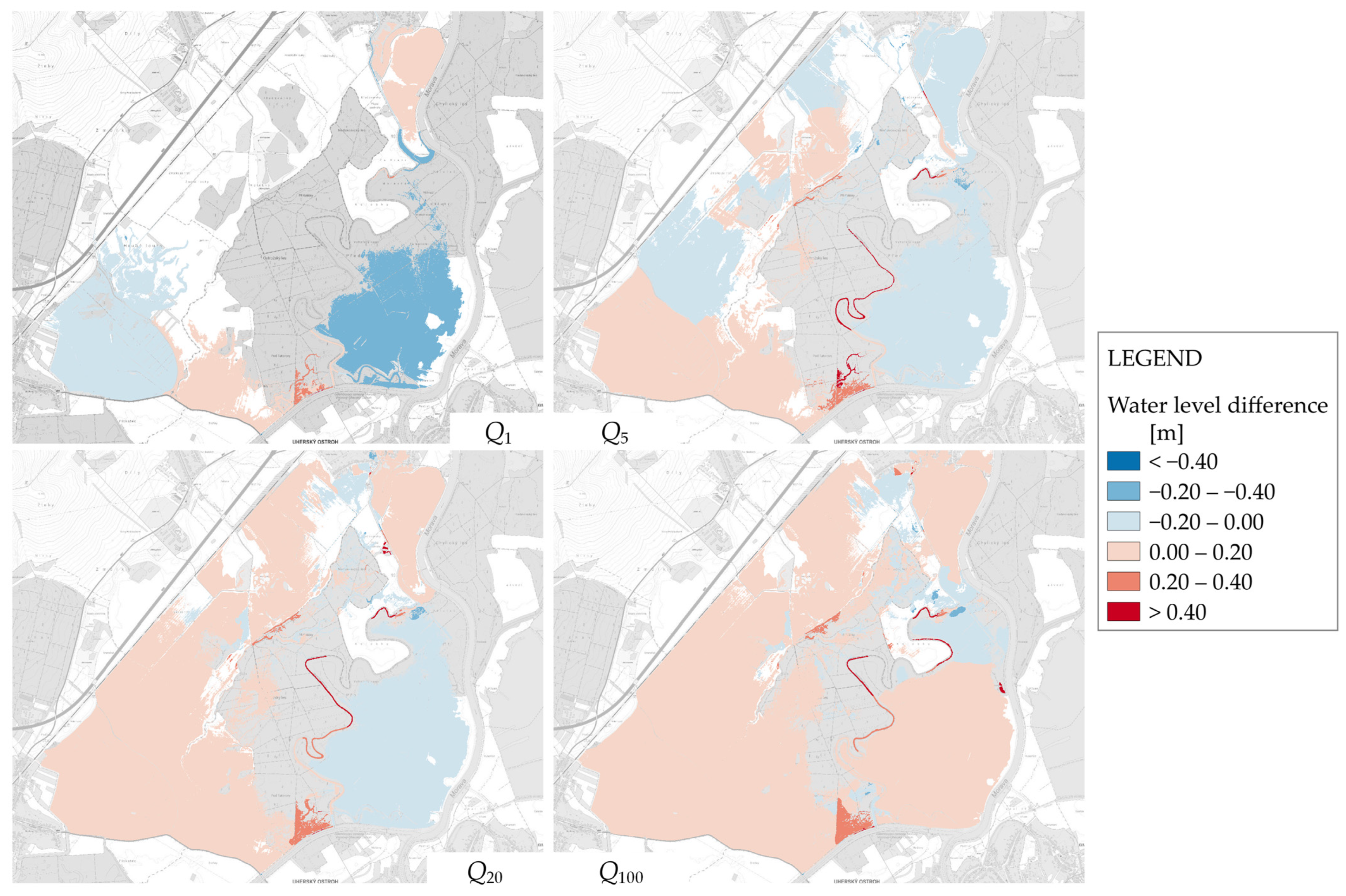
- The hydraulic modelling results are compared in terms of the obtained flooded areas and water levels. Maps of the inundation extent and water level differences are elaborated, and comparisons in selected sections are also carried out.
2.1. Description, Preparation, and Comparison of Applied DTMs
2.1.1. Description of DTMs
DTM4G
DTM5G
DTMCG
2.1.2. Preparation of DTMs
2.1.3. Comparison Between DTMs
2.1.4. DTM Adaptation for Hydraulic Modelling
2.2. Hydraulic Modelling
- Model setup;
- Model calibration;
- Steady-state hydraulic simulations for selected flood scenarios and DTM surfaces.
2.2.1. Model Setup
2.2.2. Model Calibration
2.2.3. Simulations
2.3. Comparison of Hydraulic Modelling Results
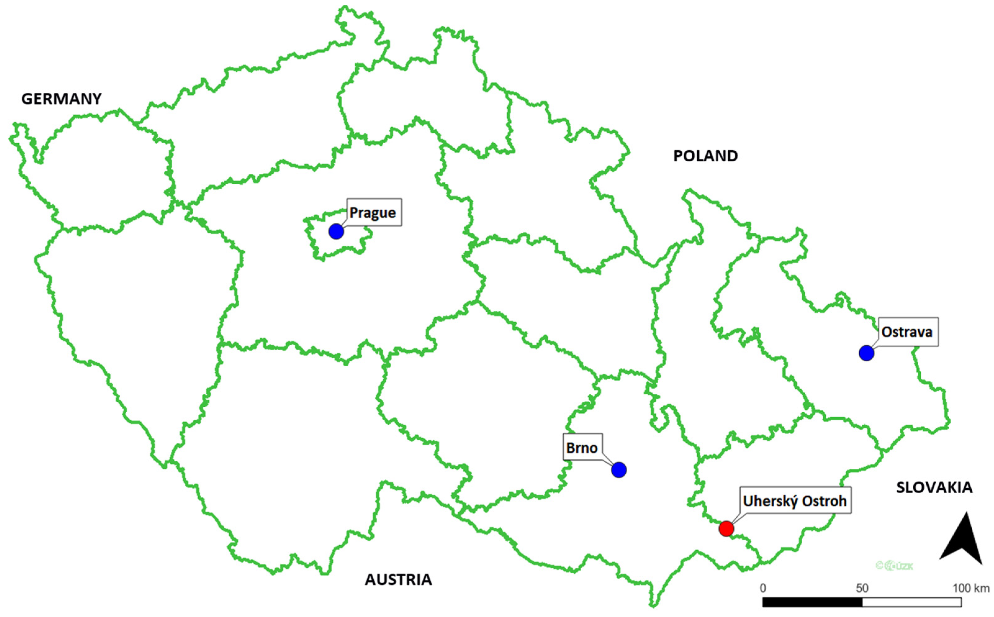
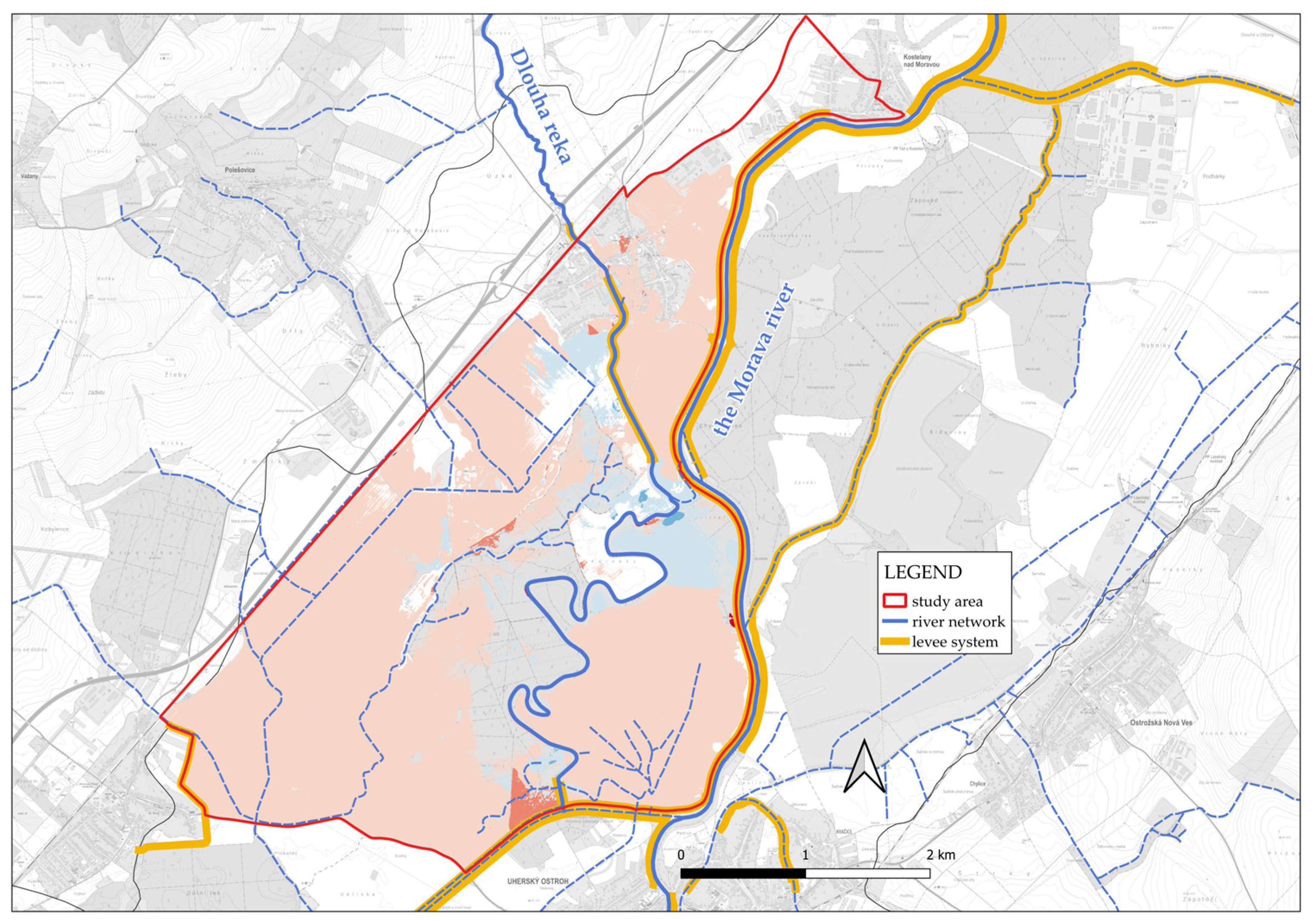
3. Study Area
4. Analysis, Results, and Discussion
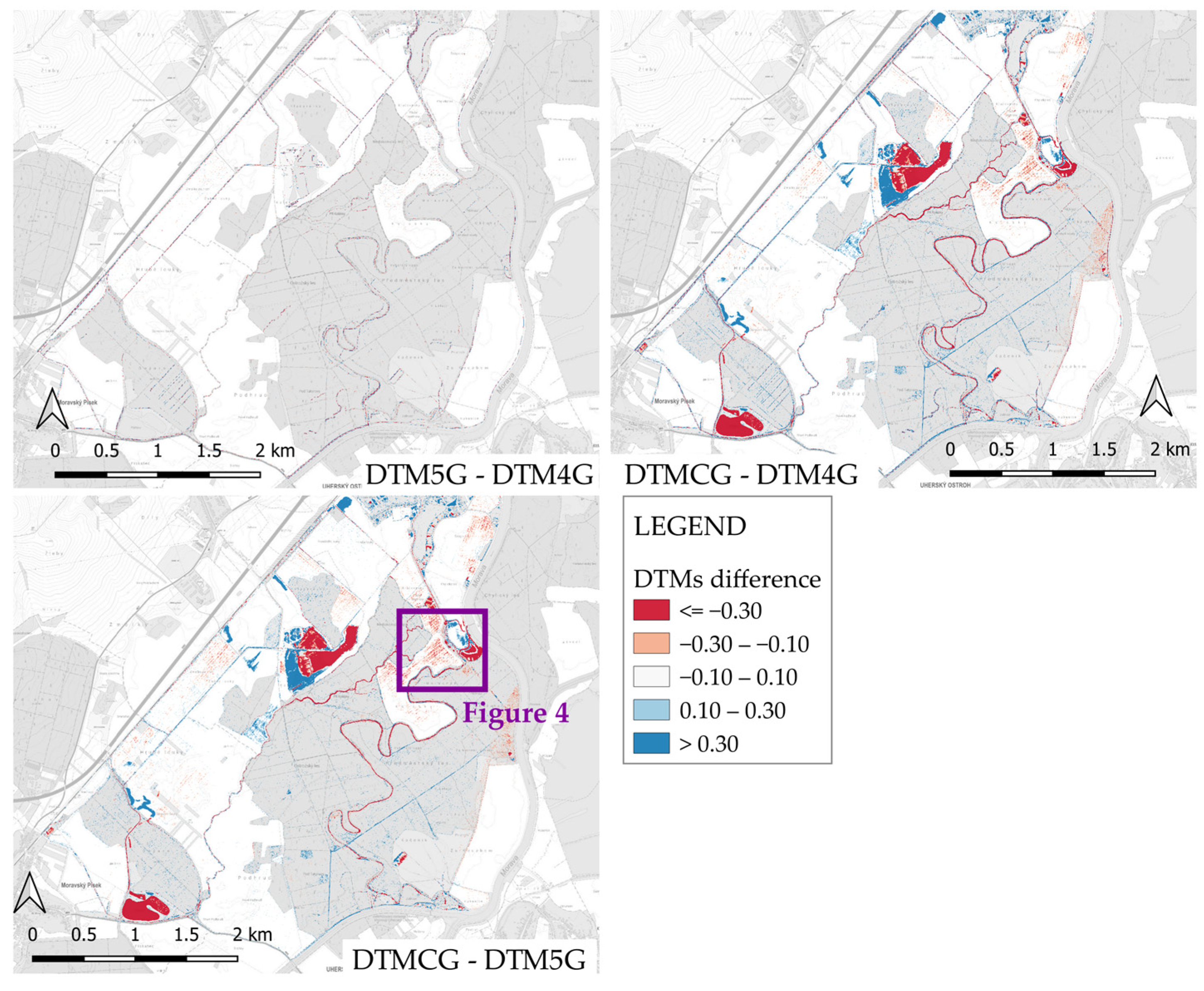
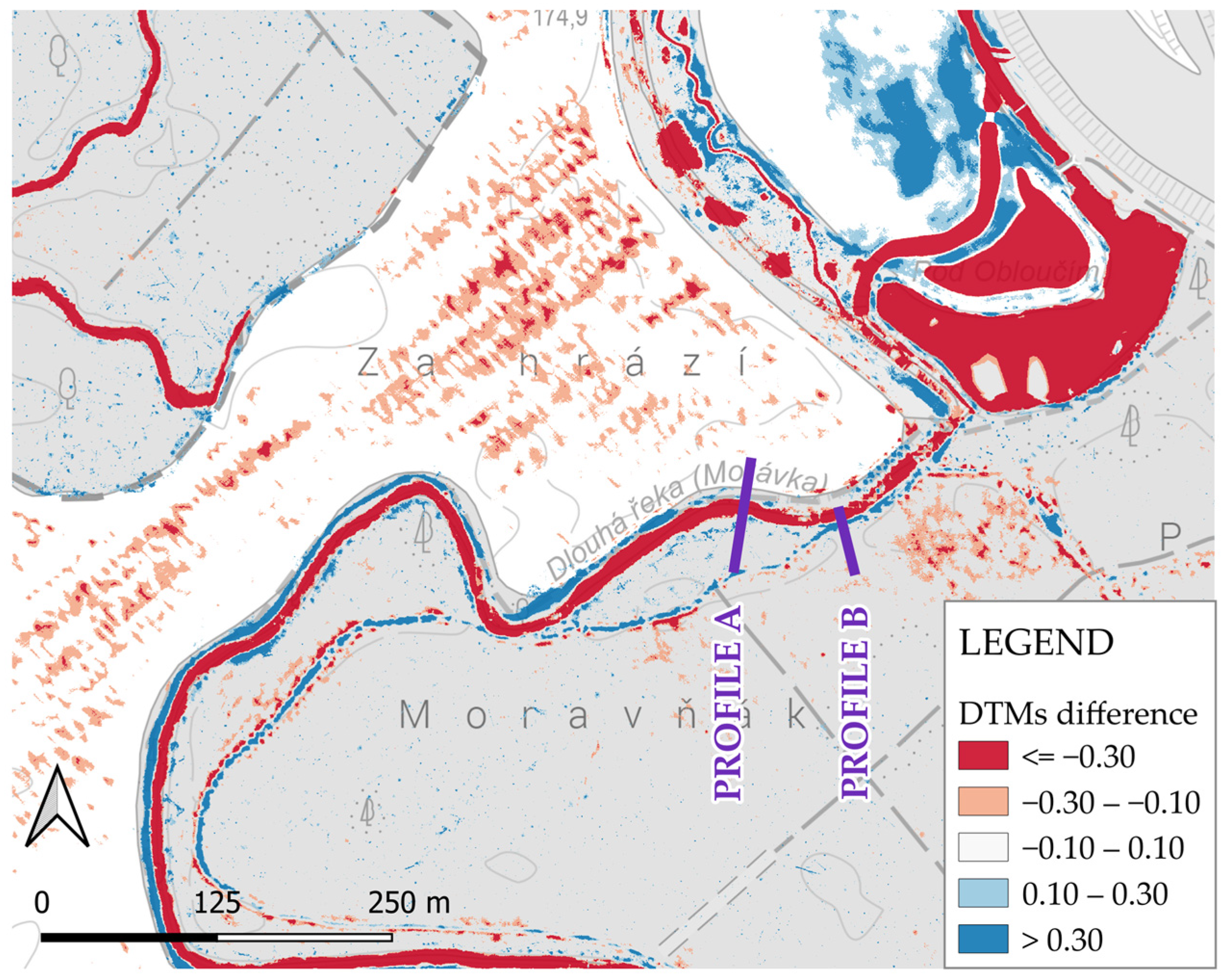
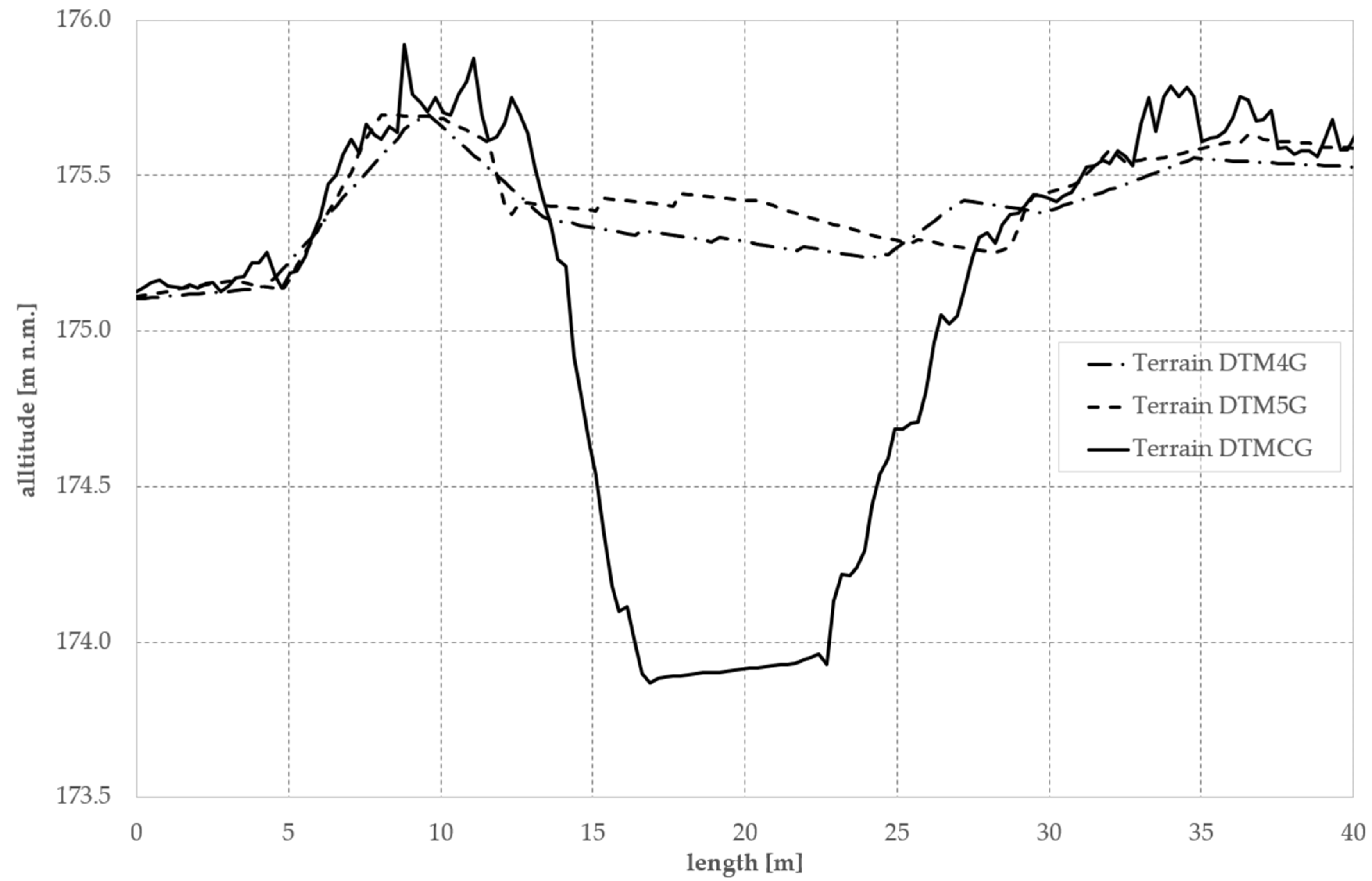
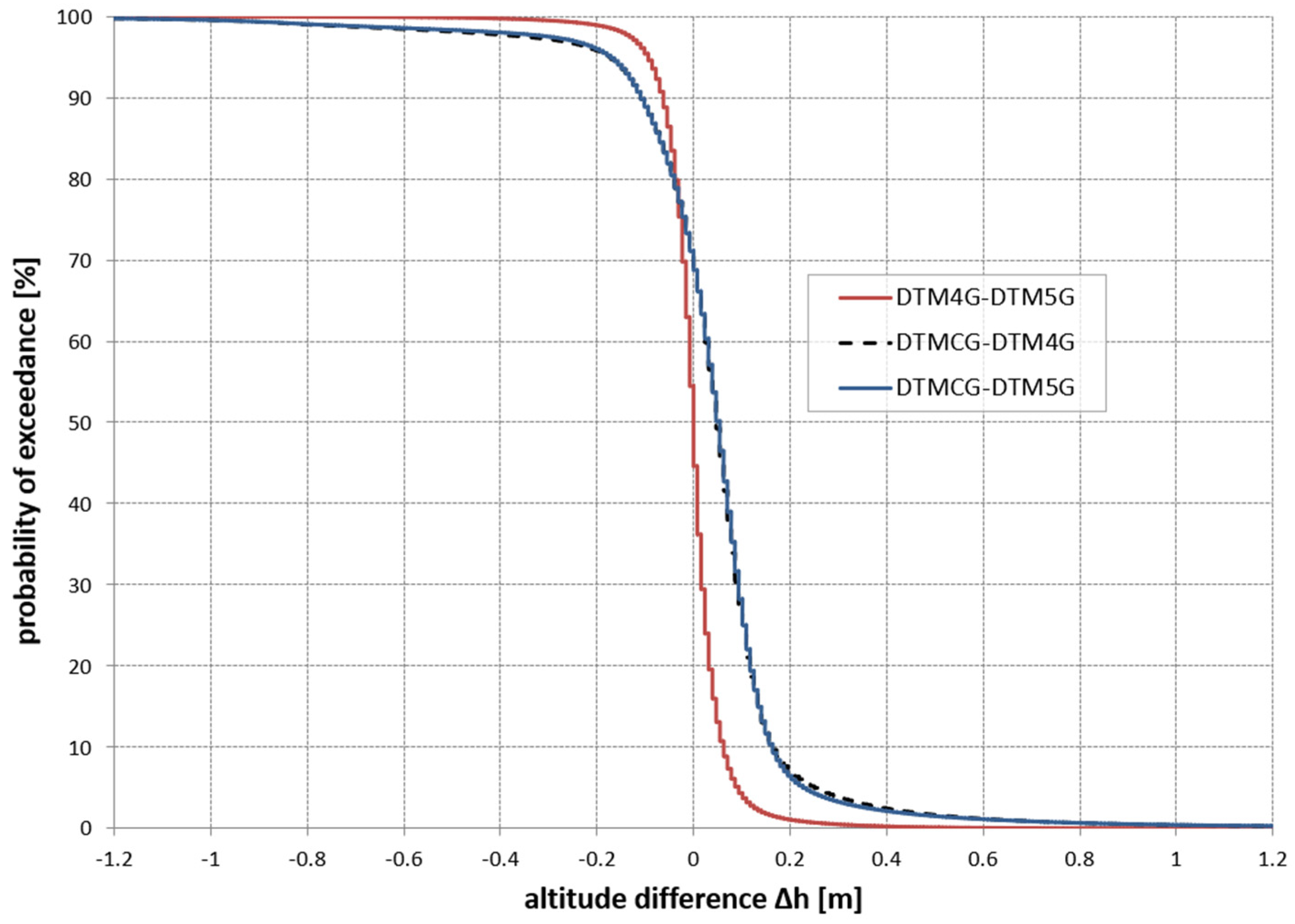
4.1. Comparison of DTMs
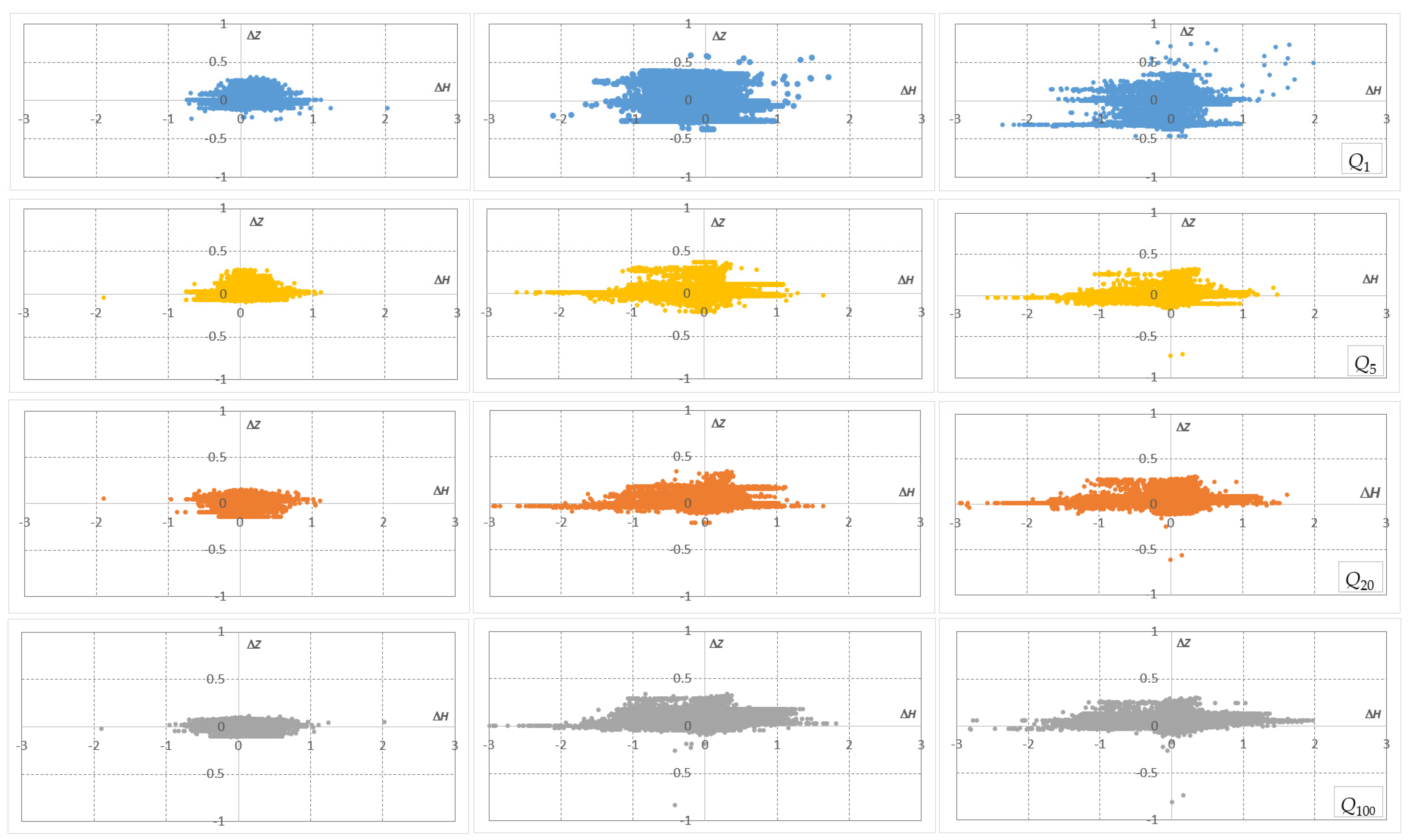
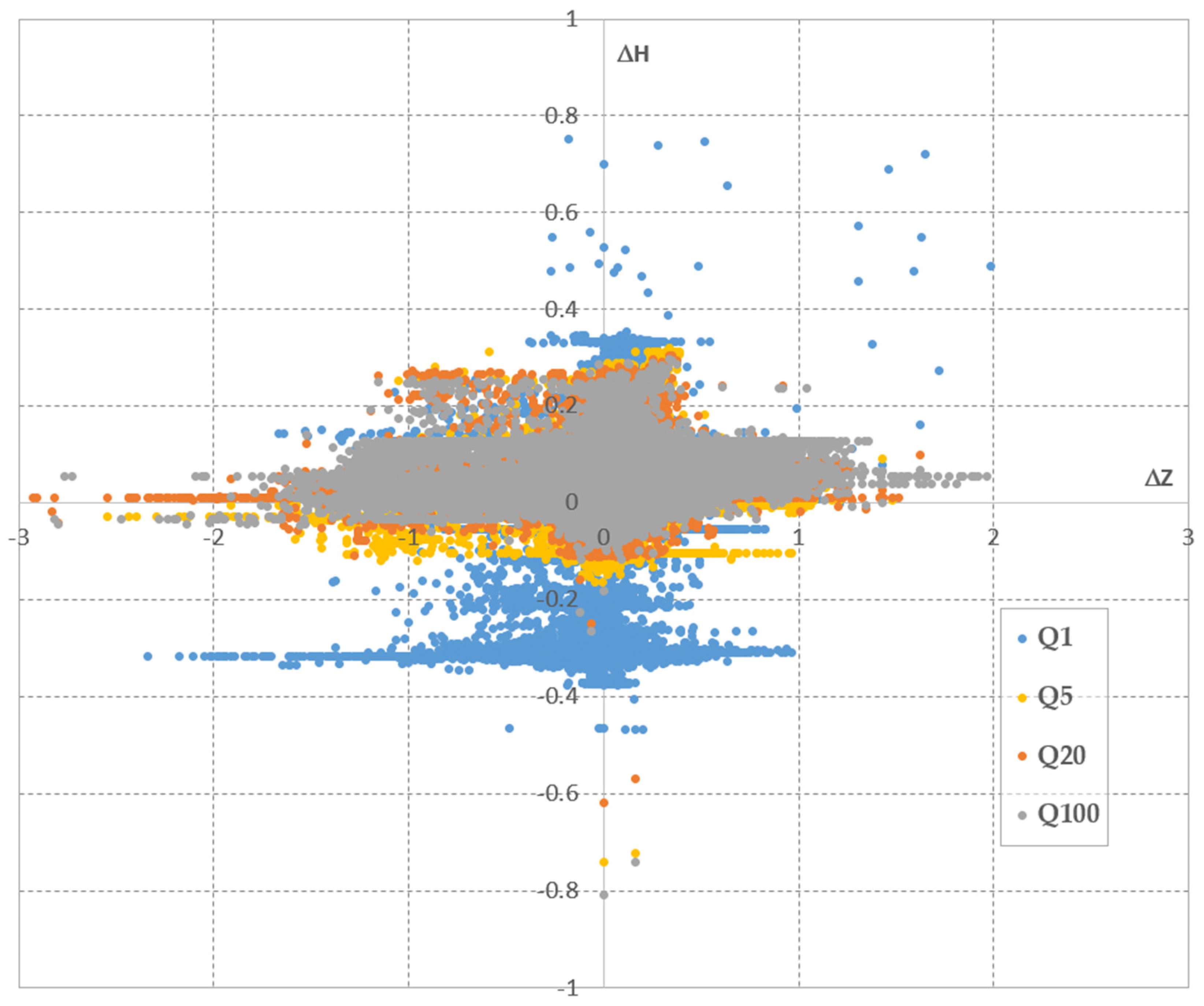
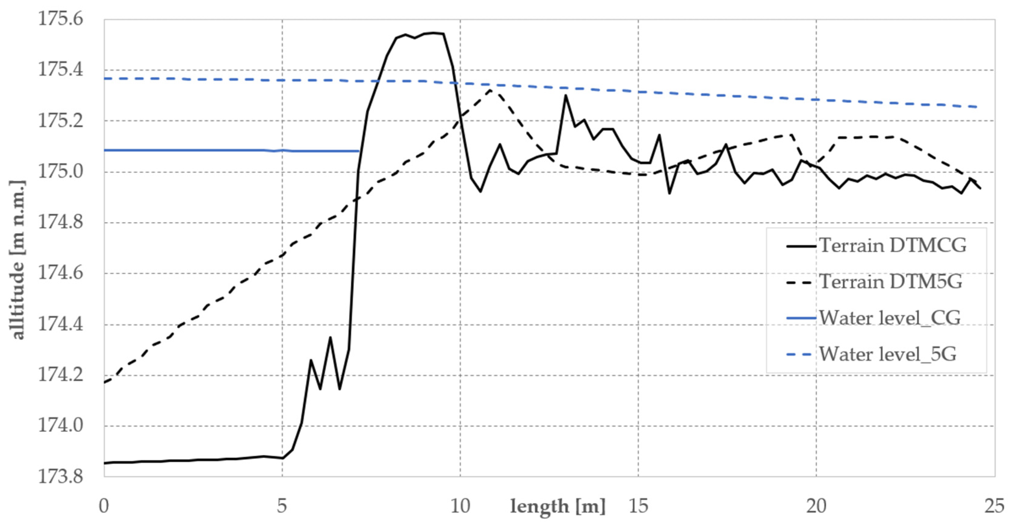
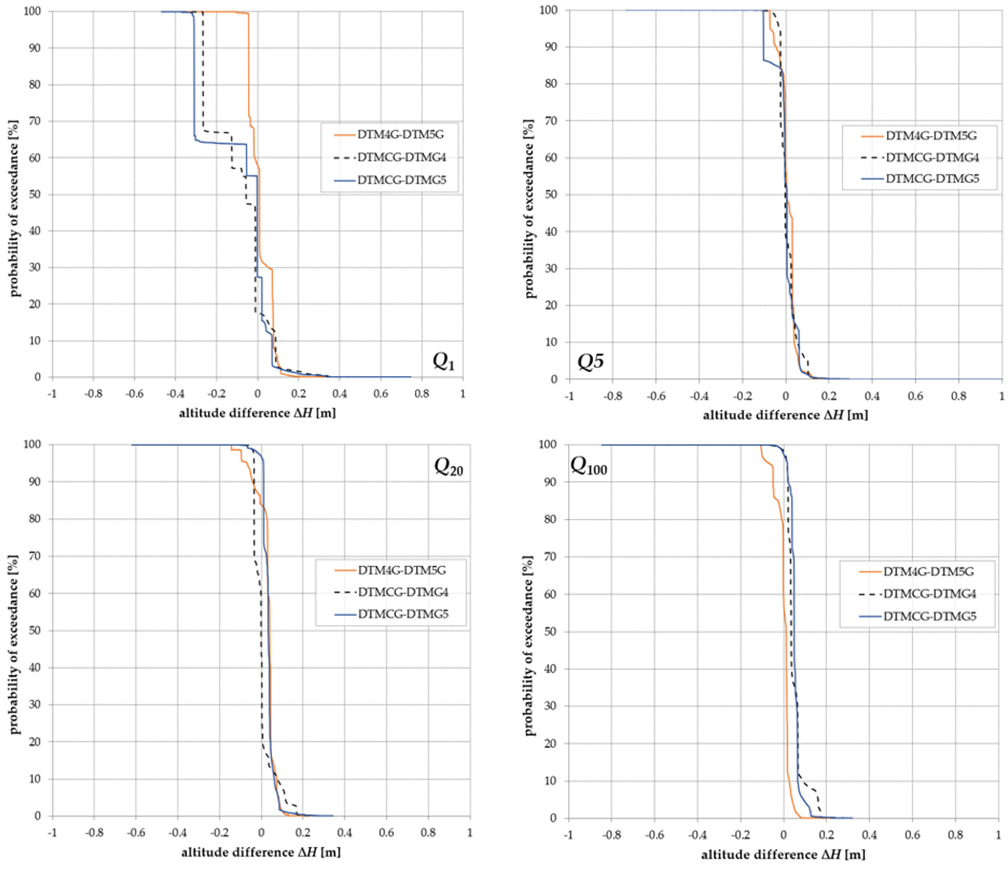
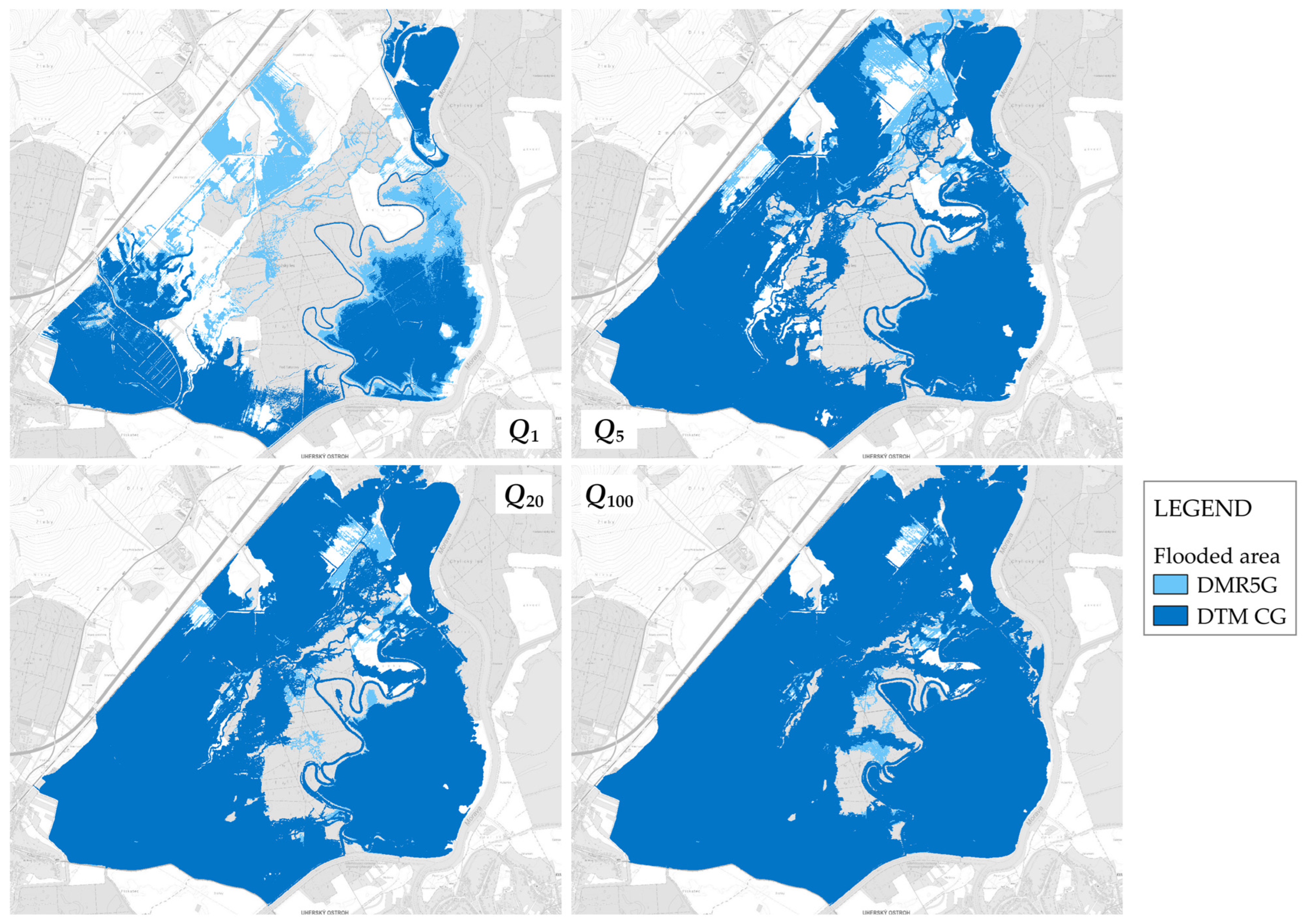
4.2. Comparison of Hydraulic Modelling Results
5. Conclusions
- There is no direct correlation between the inaccuracy of DTMs and errors in water levels obtained via hydraulic modelling.
- The differences in water levels obtained via hydraulic modelling (due to DTM inaccuracy) reduce with increasing flood discharge.
- Minor DTM differences manifesting in local terrain rises can obstruct the flow in the hydraulic model, influence the backwater upstream, and increase water levels over a large area. Conversely, a missing levee or depression in a less-accurate DTM may cause an underestimation of water levels in areas with a reasonable fit between DTMs.
- The error in the calculated water level exceeded 0.75 m for Q1 and approximately 0.33 m for Q100. This error should not be generalised and depends on the morphology and segmentation of the floodplain, the configuration of the hydraulic model, local changes and human interventions in the area, and the DTMs used, as well as their accuracy and resolution.
- The higher point cloud density when using DTMCG is associated with approximately double computational cost during pre-processing, specifically in TIN and raster generation (compared to DTM4G and DTM5G data), which should be considered in large-scale applications.
Author Contributions
Funding
Data Availability Statement
Acknowledgments
Conflicts of Interest
References
- European Parliament and Council. Directive 2007/60/EC of the European Parliament and of the Council of 23 October 2007 on the Assessment and Management of Flood Risks. Official Journal of the European Union, L 288, pp. 27–34. Available online: https://eur-lex.europa.eu/eli/dir/2007/60/oj (accessed on 25 May 2026).
- European Commission. Biodiversity Strategy 2030: Barrier Removal for River Restoration. 2021. Publications Office of the European Union. Available online: https://op.europa.eu/en/publication-detail/-/publication/0146a7ba-2f20-11ed-975d-01aa75ed71a1 (accessed on 25 May 2026).
- Casas, A.; Benito, G.; Thorndycraft, V.R.; Rico, M. The topographic data source of digital terrain models as a key element in the accuracy of hydraulic flood modelling. Earth Surf. Process. Landf. 2006, 31, 444–456. [Google Scholar] [CrossRef]
- Alho, P.; Hyyppä, H.; Hyyppä, J. Consequence of DTM Precision for Flood Hazard Mapping: A Case Study in SW Finland. Nord. J. Surv. Real Estate Res. 2009, 6, 21–39. [Google Scholar]
- Horritt, M.S.; Bates, P.D. Evaluation of 1D and 2D numerical models for predicting river flood inundation. J. Hydrol. 2002, 268, 87–99. [Google Scholar] [CrossRef]
- Shen, D.; Wang, J.; Cheng, X.; Rui, Y.; Ye, S. Integration of 2-D hydraulic model and high-resolution lidar-derived DEM for floodplain flow modeling. Hydrol. Earth Syst. Sci. 2015, 19, 3605–3616. [Google Scholar] [CrossRef]
- Bures, L.; Roub, R.; Sychova, P.; Gdulova, K.; Doubalova, J. Comparison of bathymetric data sources used in hydraulic modelling of floods. J. Flood Risk Manag. 2018, 12, e12495. [Google Scholar] [CrossRef]
- Luppichini, M.; Favalli, M.; Isola, I.; Nannipieri, L.; Giannecchini, R.; Bini, M. Influence of Topographic Resolution and Accuracy on Hydraulic Channel Flow Simulations: Case Study of the Versilia River (Italy). Remote Sens. 2019, 11, 1630. [Google Scholar] [CrossRef]
- Sanders, B.F. Evaluation of on-line DEMs for flood inundation modeling. Adv. Water Resour. 2007, 30, 1831–1843. [Google Scholar] [CrossRef]
- Xu, K.; Fang, J.; Fang, Y.; Sun, Q.; Wu, C.; Liu, M. The Importance of Digital Elevation Model Selection in Flood Simulation and a Proposed Method to Reduce DEM Errors: A Case Study in Shanghai. Int. J. Disaster Risk Sci. 2021, 12, 890–902. [Google Scholar] [CrossRef]
- Al-Ghosoun, A.; El Moçayd, N.; Seaid, M. A surrogate model for efficient quantification of uncertainties in multilayer shallow water flows. Environ. Model. Softw. 2021, 144, 105176. [Google Scholar] [CrossRef]
- Malekhosseini, S.H.; Khorshidi, H.; Szymkiewicz, R. Uncertainty analysis of simplified 1D and 2D shallow water equations via the Karhunen–Loéve expansion and Monte Carlo simulations. Stoch. Environ. Res. Risk Assess. 2023, 38, 1051–1070. [Google Scholar] [CrossRef]
- Machado, G.L. Numerical Simulation of Uncertainty Quantification for Shallow Water Models. Bachelor’s Thesis, Rijksuniversiteit Groningen, Groningen, The Netherlands, 2025. [Google Scholar]
- Reutebuch, S.E.; McGaughey, R.J.; Andersen, H.E.; Carson, W.W. Accuracy of a high-resolution lidar terrain model under a conifer forest canopy. Can. J. Remote Sens. 2003, 29, 527–535. [Google Scholar] [CrossRef]
- Müller, J.; Gärtner-Roer, I.; Thee, P.; Ginzler, C. Accuracy assessment of airborne photogrammetrically derived high-resolution digital elevation models in a high mountain environment. ISPRS J. Photogramm. Remote Sens. 2014, 98, 58–69. [Google Scholar] [CrossRef]
- Höhle, J.; Höhle, M. Accuracy assessment of digital elevation models by means of robust statistical methods. ISPRS J. Photogramm. Remote Sens. 2009, 64, 398–406. [Google Scholar] [CrossRef]
- Garrote, J. Free Global DEMs and Flood Modelling—A Comparison Analysis for the January 2015 Flooding Event in Mocuba City (Mozambique). Water 2022, 14, 176. [Google Scholar] [CrossRef]
- Javas, J.; Roesbianto, A.S.B.; Sihombing, Y.I.; Farid, M.; Adityawan, M.B.; Kuntoro, A.A.; Suwarman, R.; Yosa, I.M. Open-access digital elevation model (DEM) selection for flood inundation modelling using HEC-RAS in Capital City of Nusantara. IOP Conf. Ser. Earth Environ. Sci. 2024, 1343, 012036. [Google Scholar] [CrossRef]
- Caletka, M. Možnosti extrapolace digitálního modelu terénu z rastru DMR 5G [Possibilities of extrapolation of a digital terrain model from the DMR 5G grid]. Vodohospod. Tech.-Ekon. Inf. 2017, 59, 18–23. [Google Scholar]
- Sidek, L.M.; Jaafar, A.S.; Majid, W.H.A.W.A.; Basri, H.; Marufuzzaman, M.; Fared, M.M.; Moon, W.C. High-Resolution Hydrological-Hydraulic Modeling of Urban Floods Using InfoWorks ICM. Sustainability 2021, 13, 10259. [Google Scholar] [CrossRef]
- He, J.; Zhang, S.; Cui, X.; Feng, W. Remote sensing for shallow bathymetry: A systematic review. Earth-Sci. Rev. 2024, 258, 104957. [Google Scholar] [CrossRef]
- Tompalski, P.; Coops, N.C.; White, J.C.; Wulder, M.A.; Yuill, A. Characterizing streams and riparian areas with airborne laser scanning data. Remote Sens. Environ. 2017, 192, 73–86. [Google Scholar] [CrossRef]
- Ettritch, G.; Hardy, A.; Bojang, L.; Cross, D.; Bunting, P.; Brewer, P. Enhancing digital elevation models for hydraulic modelling using flood frequency detection. Remote Sens. Environ. 2018, 217, 506–522. [Google Scholar] [CrossRef]
- Čubanová, L.; Rumann, J.; Rutzká, A.; Vidová, A.; Dušička, P. Verification of the Manning’s Roughness Coefficient of Fish Pass Riverbeds Using Drone-Based Photogrammetry. Water 2025, 17, 1409. [Google Scholar] [CrossRef]
- CUZK. DMR 5G Technical Report; CUZK: Prague, Czech Republic, 2016. [Google Scholar]
- Knapík, J. Technical Report to the Digital Terrain Models of the 4th and 5th Generation (DTM4G, DTM5G); Land-Surveying Administration: Pardubice, Czech Republic, 2025.
- Delaunay, B. Sur la Sphère Vide. A la Mémoire de Georges Voronoï. Bulletin de l’Académie des Sciences de l’URSS. Classe des Sciences Mathématiques et Naturelles. Leningrad, USSR, 1934, No. 6, pp. 793–800. Available online: http://mi.mathnet.ru/eng/im4937 (accessed on 25 May 2026).
- Brunner, G.W. HEC-RAS Hydraulic Reference Manual; U.S. Army Corps of Engineers: Washington, DC, USA, 2020.
- Vreugdenhil, C.B. Numerical Methods for Shallow-Water Flow; Kluwer Academic Publishers: Dordrecht, The Netherlands, 1998. [Google Scholar]





| Flood Scenario–Return Period N [Years] | Flood Discharge [m3/s] | Digital Terrain Model | ||
|---|---|---|---|---|
| DTM4G | DTM5G | DTMCG | ||
| 1 | 4.1 | X | X | X |
| 5 | 10.1 | X | X | X |
| 20 | 20.6 | X | X | X |
| 100 | 41.8 | X | X | X |
| Surface Type | Data Source | No. of Points | min_ΔZ [m] | max_ΔZ [m] | CH [m] | RMSE [m] |
|---|---|---|---|---|---|---|
| Levees without trees | DTM4G | 2844 | −1.012 | 0.276 | −0.184 | 0.255 |
| DTM5G | 2844 | −0.910 | 0.352 | 0.029 | 0.103 | |
| DTM CG | 2844 | −0.163 | 0.314 | 0.048 | 0.062 | |
| Solid open surface | DTM4G | 18 | −0.307 | −0.013 | −0.109 | 0.132 |
| DTM5G | 18 | −0.300 | 0.026 | −0.119 | 0.144 | |
| DTM CG | 18 | −0.003 | 0.045 | 0.020 | 0.024 | |
| Levees partially shaded by trees | DTM4G | 114 | −0.325 | 0.042 | −0.130 | 0.153 |
| DTM5G | 114 | −0.296 | 0.086 | −0.047 | 0.028 | |
| DTM CG | 114 | −0.033 | 0.136 | 0.051 | 0.055 |
| Flooded Area/Difference in Flooded Area [m2] | ||||
|---|---|---|---|---|
| Q1 | Q5 | Q20 | Q100 | |
| ADTM4G | 6,879,830 | 8,646,124 | 10,014,045 | 11,792,796 |
| ADTM5G | 6,128,987 | 8,159,452 | 9,523,307 | 11,657,731 |
| ADTMCG | 4,501,616 | 7,625,233 | 9,427,562 | 11,767,930 |
| ∆A4-5 | 750,843 | 486,672 | 490,738 | 135,065 |
| ∆ACG-4 | −2,378,214 | −1,020,891 | −586,483 | −24,866 |
| ∆ACG-5 | −1,627,371 | −534,219 | −95,745 | 110,199 |
| Flood Scenario | Differences | min_ΔZ [m] | max_ΔZ [m] | min_ΔH [m] | max_ΔH [m] | MAE [m] |
|---|---|---|---|---|---|---|
| Q1 | ∆Z4-5; ∆H4-5 | −0.742 | 1.117 | −0.251 | 0.299 | 0.057 |
| ∆ZCG-4; ∆HCG-4 | −2.109 | 1.711 | −0.383 | 0.585 | 0.183 | |
| ∆ZCG-5; ∆HCG-5 | −2.336 | 1.984 | −0.467 | 0.752 | 0.191 | |
| Q5 | ∆Z4-5; ∆H4-5 | −1.891 | 1.117 | −0.095 | 0.281 | 0.050 |
| ∆ZCG-4; ∆HCG-4 | −2.578 | 1.648 | −0.216 | 0.364 | 0.119 | |
| ∆ZCG-5; ∆HCG-5 | −2.547 | 1.484 | −0.163 | 0.319 | 0.117 | |
| Q20 | ∆Z4-5; ∆H4-5 | −1.891 | 1.117 | −0.143 | 0.146 | 0.059 |
| ∆ZCG-4; ∆HCG-4 | −2.938 | 1.648 | −0.215 | 0.343 | 0.105 | |
| ∆ZCG-5; ∆HCG-5 | −2.930 | 1.625 | −0.159 | 0.305 | 0.105 | |
| Q100 | ∆Z4-5; ∆H4-5 | −1.891 | 2.031 | −0.109 | 0.109 | 0.047 |
| ∆ZCG-4; ∆HCG-4 | −2.984 | 1.813 | −0.196 | 0.330 | 0.101 | |
| ∆ZCG-5; ∆HCG-5 | −3.797 | 1.969 | −0.117 | 0.297 | 0.096 |
Disclaimer/Publisher’s Note: The statements, opinions and data contained in all publications are solely those of the individual author(s) and contributor(s) and not of MDPI and/or the editor(s). MDPI and/or the editor(s) disclaim responsibility for any injury to people or property resulting from any ideas, methods, instructions or products referred to in the content. |
© 2026 by the authors. Licensee MDPI, Basel, Switzerland. This article is an open access article distributed under the terms and conditions of the Creative Commons Attribution (CC BY) license.
Share and Cite
Říha, J.; Julínek, T.; Skokan, J.; Duchan, D.; Jelínková, I.; Pikl, M.; Zemek, F. Accuracy of the Digital Terrain Model and Its Impact on the Results of Hydraulic Modelling in Floodplains. Water 2026, 18, 1312. https://doi.org/10.3390/w18111312
Říha J, Julínek T, Skokan J, Duchan D, Jelínková I, Pikl M, Zemek F. Accuracy of the Digital Terrain Model and Its Impact on the Results of Hydraulic Modelling in Floodplains. Water. 2026; 18(11):1312. https://doi.org/10.3390/w18111312
Chicago/Turabian StyleŘíha, Jaromír, Tomáš Julínek, Jiří Skokan, David Duchan, Iva Jelínková, Miroslav Pikl, and František Zemek. 2026. "Accuracy of the Digital Terrain Model and Its Impact on the Results of Hydraulic Modelling in Floodplains" Water 18, no. 11: 1312. https://doi.org/10.3390/w18111312
APA StyleŘíha, J., Julínek, T., Skokan, J., Duchan, D., Jelínková, I., Pikl, M., & Zemek, F. (2026). Accuracy of the Digital Terrain Model and Its Impact on the Results of Hydraulic Modelling in Floodplains. Water, 18(11), 1312. https://doi.org/10.3390/w18111312