Article

Hydrochemical Characteristics and Formation Mechanisms of Waters in the Xianglaqu Basin, a Typical Endorheic Basin of the Tibetan Plateau

1
College of Geosciences and Engineering, North China University of Water Resources and Electric Power, Zhengzhou 450003, China
2
Institute of Hydrogeology & Environmental Geology, Chinese Academy of Geological Sciences, Shijiazhuang 050061, China
3
Key Laboratory of Groundwater Remediation of Hebei Province and China Geological Survey, Shijiazhuang 050061, China
*
Author to whom correspondence should be addressed.
Water 2026, 18(10), 1180; https://doi.org/10.3390/w18101180
Submission received: 29 March 2026 / Revised: 29 April 2026 / Accepted: 10 May 2026 / Published: 13 May 2026
(This article belongs to the Special Issue Assessment of Groundwater Quality and Pollution Remediation)

Abstract

The Xianglaqu River Basin, a major recharge area of the Xiagacuo endorheic lake basin on the Tibetan Plateau, provides an ideal setting for investigating hydrochemical evolution in alpine arid closed basins. In this study, 27 groundwater, spring-water, and surface-water samples collected from June to August 2023 were analyzed using correlation analysis, Piper diagrams, Gibbs diagrams, and ion-ratio methods. The results show that groundwater, spring water, and most surface water are predominantly of the HCO3–Ca·Mg type, indicating overall hydrochemical consistency across the basin. However, marked spatial differentiation occurs along the flow system: upstream waters are relatively simple and stable, whereas downstream and terminal surface waters show pronounced increases in Na+, Cl, SO42−, and TDS, and some samples exhibit a tendency toward HCO3–Na facies. These patterns reflect progressive solute accumulation and terminal enrichment in the closed basin. Hydrochemical evolution is controlled mainly by water–rock interaction, with carbonate weathering as the dominant source of major ions, while silicate weathering, minor local saline-mineral dissolution, cation exchange, and evaporation concentration further influence water chemistry. Overall, the basin is characterized by local weathering release, along-path solute accumulation, and terminal evaporative enrichment.

1. Introduction

The Tibetan Plateau, known as the “Roof of the World” and the “Asian Water Tower”, is crucial for water security and ecological conservation in Asia. Since the 1950s, the Plateau has experienced marked warming and humidification, with temperature increases exceeding the global average, overall increasing precipitation, cryospheric degradation, and growing imbalances in water resources [1], posing serious challenges to ecological and environmental protection in surrounding regions. Hydrogeochemistry is an effective tool for understanding water–rock interactions, solute migration and transformation, and environmental change within river basins. Endorheic lake basins, developed in closed or relatively closed drainage systems, are mainly recharged by basin-internal precipitation, snow and ice meltwater, surface runoff, and groundwater, with water ultimately converging in lakes or depressions and being depleted through evaporation and seepage. These systems are therefore characterized by pronounced internal water–salt cycling and solute enrichment, making them ideal natural laboratories for investigating hydrochemical evolution and lake salinization in high-cold arid regions. However, studies on the hydrochemical characteristics of endorheic lake basins on the Tibetan Plateau and their hydrological implications remain limited.
Groundwater and surface water within the same basin commonly exhibit varying degrees of hydraulic connection, and their chemical compositions continuously respond to environmental changes during recharge, runoff, and discharge [2]. Thus, major-ion compositions can reflect carbonate weathering, silicate weathering, evaporation concentration, and ion exchange, while also indicating interactions among different water bodies and basin-scale solute migration. Previous studies have shown that the hydrochemical evolution of groundwater and river water is generally controlled by rock weathering, water–rock interaction, and cation exchange. For example, Zhao Nayan et al. [3] showed that groundwater solutes in the plain area of the Tizinafu River Basin in Xinjiang mainly originate from rock weathering and are also affected by cation exchange. Jin Zengcheng et al. [4] concluded from Gibbs diagrams that river-water ion concentrations are related to rock weathering. Sheng Huibin et al. [5] found that groundwater hydrochemistry in the Futuan River Basin of Rizhao is mainly controlled by water–rock interaction and cation exchange. Although these studies provide useful references, systematic understanding of the hydrochemical evolution of different water bodies and its hydrological significance remains insufficient for endorheic basins in the high-cold arid regions of the Tibetan Plateau, especially within integrated flow systems linking recharge, runoff, and terminal accumulation zones.
The Xianglaqu River Basin, located within the Xiagacuo endorheic lake basin, is an important recharge area with hydrogeological characteristics typical of a high-cold arid closed basin. The coexistence of groundwater, spring water, and surface water provides favorable conditions for investigating hydrochemical differentiation and its controlling mechanisms. Therefore, this study aims to undertake the following: (1) clarify the hydrochemical composition characteristics and spatial differentiation patterns of groundwater, spring water, and surface water; (2) identify the main processes controlling hydrochemical evolution in the basin, including water–rock interaction, evaporation concentration, and ion exchange; and (3) explore the indicative significance of hydrochemical characteristics for surface water–groundwater interactions and solute accumulation in the endorheic basin. The results provide a scientific basis for understanding hydrochemical evolution, lake-basin salinization, water-resource assessment, and ecological-environmental monitoring in typical endorheic basins on the Tibetan Plateau.

2. Materials and Methods

2.1. Overview of the Study Area

Xiagacuo Lake, into which the lower reaches of the Xianglaqu River discharge, is located in the southern part of Geze County, Ali Prefecture, Tibet Autonomous Region (Figure 1C), at approximately 84°05′ E and 32°29′ N. It lies about 20 km from the county seat, with National Highway 317 extending along the lakeshore. The lake has a surface elevation of approximately 4460 m and an area of about 21.6 km2, the lake has a relatively high degree of mineralization. Among the collected surface water samples, the maximum TDS value reached 3740 mg/L, indicating that it can be classified as saline water according to the salinity classification. Situated within the Bangong Co–Nujiang Suture Zone, Xiagacuo is an inland saline lake on the Tibetan Plateau and forms a typical hydrological system of an endorheic lake basin in the plateau interior. It is also an important component of the Qiangtang National Nature Reserve and a key geographic landmark along the transportation route in southern Geze County.
The Xianglaqu River is one of the major recharge rivers of Xiagacuo Lake Basin, with its watershed located in the western part of the basin (Figure 1A). The study area lies in the Tibet Autonomous Region of the People’s Republic of China (Figure 1B). Xiagacuo Lake, which receives discharge from the lower reaches of the Xianglaqu River, is situated in southern Ali Prefecture, Tibet Autonomous Region (Figure 1C). The basin is characterized by a high-elevation hilly plateau landscape (Figure 1D), covering an area of 420.77 km2, with a perimeter of 109.3 km and an elevation range of 4325–5630 m. Topographically, the region is generally higher in the central and northwestern parts and lower in the southeast. The principal geomorphic units include the high-elevation hilly plateau, river valleys, and the low-elevation lake basin. This topographic framework strongly controls the unidirectional hydrological pathway of the Xianglaqu River system, which flows from the northwestern and central highlands toward the southeastern lake basin, forming an integrated hydrological continuum of “high-elevation recharge area–valley runoff zone–low-elevation catchment area”.
The study area is located in a semi-arid-to-arid plateau climatic zone. According to data from the Geze Meteorological Station (Station No. 55248) for 1973–2023, the mean monthly precipitation, evaporation, and air temperature are 15.45 mm, 172.79 mm, and 0.59 °C, respectively, with mean monthly evaporation being 11.18 times greater than precipitation. The maximum monthly precipitation was 201 mm in July 2017, while the maximum monthly evaporation was 385 mm in June 1995. In the year when the maximum monthly precipitation was recorded, the annual precipitation totaled 370.2 mm, accounting for only 22.75% of the annual evaporation. The highest recorded temperature was 16.4 °C in July 2024, and the lowest was −22 °C in December 1978. Overall, the study area is characterized by a dry climate with scarce precipitation and evaporation far exceeding precipitation, which strongly influences the basin’s hydrological cycle and hydrochemical evolution.

2.2. Sampling

From June to August 2023, field reconnaissance and sampling were carried out in the Xianglaqu River Basin. A total of 27 water samples were collected, including 12 groundwater samples (GW01–GW12), 8 spring-water samples (SPW01–SPW08), and 7 surface-water samples (SUW01–SUW07) (Figure 1A). All groundwater samples were collected from domestic wells used by local residents, with water table depths ranging from 1.9 to 25.54 m and temperatures of 7.3–11.4 °C. Spring water temperatures ranged from 6.9 to 16.3 °C. Surface water samples were mainly collected from the main river channel, with temperatures ranging from 9.5 to 15.7 °C. Only sample SUW07 was taken from the river–lake confluence zone, where the river discharges into the lake. Its TDS value reached 3740 mg/L, significantly higher than those of the other sampling sites. Parameters such as pH, water temperature (T), total dissolved solids (TDSs), redox potential (Eh), and dissolved oxygen (DO) were measured in situ using a portable multiparameter analyzer (DZB-712, Leici, Shanghai, China). Water samples were collected in 500 mL polyvinyl chloride plastic bottles, filled completely, protected from light, and transported to the laboratory for further analysis.
The sampling strategy in this study was designed to capture the major hydrogeomorphic positions and water types within the Xianglaqu endorheic basin rather than to provide a probabilistic statistical survey. The 27 samples collected during June–August 2023 are therefore considered representative for identifying first-order hydrochemical differences and along-path evolution within the basin-scale flow system. The sampling sites were selected to represent the main hydrogeomorphic units of the basin, including upstream recharge areas, valley runoff zones, spring discharge sites, and downstream/terminal accumulation zones. Groundwater samples mainly represent the shallow local groundwater system, spring water was treated as a discharge expression of groundwater, and surface water represents the main river and terminal waters. Because all samples were collected within the same season, the dataset is more appropriate for evaluating spatial hydrochemical differentiation than seasonal variation. The groundwater samples in this study mainly represent the shallow local groundwater circulation system of the Xianglaqu Basin, including fractured groundwater in the mountainous area and its transition into Quaternary porous groundwater in valleys and the lake-basin margin. Spring water represents local discharge of this same shallow flow system. Thus, the main purpose of the sampling layout was to compare hydrochemical relationships among groundwater, spring water, and surface water within a basin-scale shallow flow framework, rather than among different deep aquifer systems.
The hydrochemical analytical results were provided by the Institute of Hydrogeology and Environmental Geology, the Chinese Academy of Geological Sciences (Groundwater, Mineral Water and Environmental Monitoring Center, Ministry of Natural Resources of the People’s Republic of China, Institutional address: No. 92, East Zhongshan Road, Zhengding County, Shijiazhuang, China). Concentrations of K+, Na+, Ca2+, and Mg2+ were determined using an inductively coupled plasma optical emission spectrometer (ICP-OES; Avio 550 Max, PerkinElmer, Waltham, MA, USA) in accordance with <<Water Quality—Determination of 32 Elements—Inductively Coupled Plasma Optical Emission Spectrometry>> (HJ 776-2015). Concentrations of CO32−, Cl, SO42−, and HCO3 were determined by titration using a 25 mL acid burette following <<Methods for Analysis of Groundwater Quality, Part 49: Determination of Carbonate, Bicarbonate, and Hydroxide Ions—Titration Method>> (DZ/T 0064.49-2021). The concentration of NO3 was measured using an ion chromatograph (Metrohm 930, Helisau, Switzerland) according to <<Water Quality—Determination of Inorganic Anions (F, Cl, NO2, Br, NO3, PO43−, SO32−, and SO42−)—Ion Chromatography>> (H J 84-2016).

2.3. Sampling and Chemical Analysis

This study employs correlation analysis [6], Piper trilinear diagrams [7], Gibbs diagrams [8], ion-ratio end-member diagrams [9], and ion-ratio plots [10,11] to examine the hydrogeochemical characteristics of the basin. Based on these approaches, the hydrochemical ionic features of basin waters and their evolutionary causes are qualitatively analyzed, with the aim of providing insight into the characteristics of inflow rivers in typical endorheic lake basins on the Tibetan Plateau.
Preliminary data processing was performed using Excel for the preparation of the required figures. ArcGIS 10.8 was used to generate the map showing the location of the study area and the distribution of sampling points. Omap 10.5.6 was employed to delineate the study area and extract shapefiles of the sampling locations. Origin 2024 was used to prepare diagrams of ionic characteristics and to conduct related data analysis, whereas IBM SPSS Statistics 25 was used for multivariate statical analysis.

3. Results

3.1. Statistical Hydrochemical Characteristics

The three water types in the basin display a distinct hydrochemical gradient (Table 1). Groundwater has the lowest mean ion concentrations among the three, with mean HCO3, Ca2+, and Cl concentrations of 203.73 mg/L, 39.52 mg/L, and 10.62 mg/L, respectively. The coefficients of variation (CV) for all ions are below 0.33, indicating weak to moderately weak variability, and its ionic composition is characterized by Ca2+ as the dominant cation and HCO3 as the dominant anion. The mean values of the integrated parameters are 7.89 for pH (CV = 0.02), 263.92 mg/L for TDS (CV = 0.20), 5.11 mg/L for DO (CV = 0.21), and 144.17 mV for Eh (CV = 0.16), all with CVs below 0.21. The overall low variability in major ions and integrated indicators suggests that groundwater chemistry is relatively stable. Together with its relatively low DO and moderate Eh, this indicates that groundwater is less susceptible to external disturbance than surface water, and that its hydrochemical composition primarily records water–rock interaction during hydrological circulation [12].
Spring water in the basin represents a transitional water type between groundwater and surface water. Its mean ion concentrations are generally intermediate between those of groundwater and surface water, with mean HCO3, Na+, SO42−, and NO3 concentrations of 330.13, 46.56, 43.26, and 6.02 mg/L, respectively. The coefficients of variation (CVs) for most ions fall within the range of 0.3–1.0, indicating moderate variability. The mean values of the integrated parameters are 7.94 for pH (CV = 0.06), 379 mg/L for TDS (CV = 0.51), 6.20 mg/L for DO (CV = 0.23), and 120.38 mV for Eh (CV = 0.44), with overall variability between that of groundwater and surface water. Notably, spring water shows markedly higher concentrations of Na+, Mg2+, and SO42− than groundwater. This moderate variability is likely related to differences in recharge depth and flow paths among spring outlets. As a transitional water body formed by the local discharge of groundwater, spring water preserves some hydrochemical characteristics inherited from groundwater water–rock interaction, while also being affected by exposure to the surface environment and a certain degree of evaporation after emergence.
Surface water in the basin is characterized by mean HCO3, Na+, Cl, and SO42− concentrations of 640.04, 393.72, 150.38, and 202.11 mg/L, respectively. Several ions show strong variability (CV > 1.0), especially Na+ (CV = 1.49), Cl (CV = 1.50), and SO42− (CV = 1.28). Na+ is the dominant cation, whereas Cl and SO42− are the principal anions. The mean values of the integrated parameters are 8.30 for pH (CV = 0.09), 1321 mg/L for TDS (CV = 1.21, about five times that of groundwater), 6.72 mg/L for DO (CV = 0.13), and 91.27 mV for Eh (CV = 0.30), although most TDS values remain below 1000 mg/L. Compared with groundwater and spring water, surface water has markedly higher major-ion concentrations and exhibits strong variability in Na+, Cl, and SO42−. Its mean TDS is likewise much higher, largely due to the exceptionally high values at SUW05 and SUW07, which substantially increase the overall mean and variability. These features indicate pronounced spatial heterogeneity in surface-water hydrochemistry and significant solute enrichment at terminal sites.
The strong co-variation in TDS and ionic concentrations, together with the weak variability in the remaining physical parameters, suggests that surface water occurs in an open oxidizing environment with relatively high DO and pH values. In this closed basin, the absence of an external drainage outlet favors salt retention, making evaporation concentration the dominant process responsible for the high ion concentrations and strong variability. The exposed strata in the study area cover a wide geological age range, mainly comprising the Quaternary, Cretaceous, and Jurassic systems. The Quaternary is the most widely distributed unit and forms the dominant surface cover in the study area. It can be subdivided into the Upper Pleistocene and Holocene, and includes several genetic types, such as alluvial–pluvial, lacustrine, pluvial, slope–pluvial, and marsh deposits. Lithologically, these deposits are mainly composed of muddy gravel, muddy pebble, sand, silty clay, and sub-clay, with local occurrences of silt and organic-rich sediments. The Cretaceous strata are lithologically diverse, consisting mainly of basalt, conglomerate, gravelly sandstone, sandstone, and limestone. The Jurassic strata are characterized primarily by siltstone, silty shale, and thin-bedded sandstone., intensified weathering of carbonate and silicate rocks further contributes to solute accumulation. Differences in recharge sources and evaporation intensity among river reaches and lake waters are therefore the key controls on the spatial heterogeneity of ionic composition and mineralization.

3.2. Hydrochemical Types and Spatial Distribution Characteristics

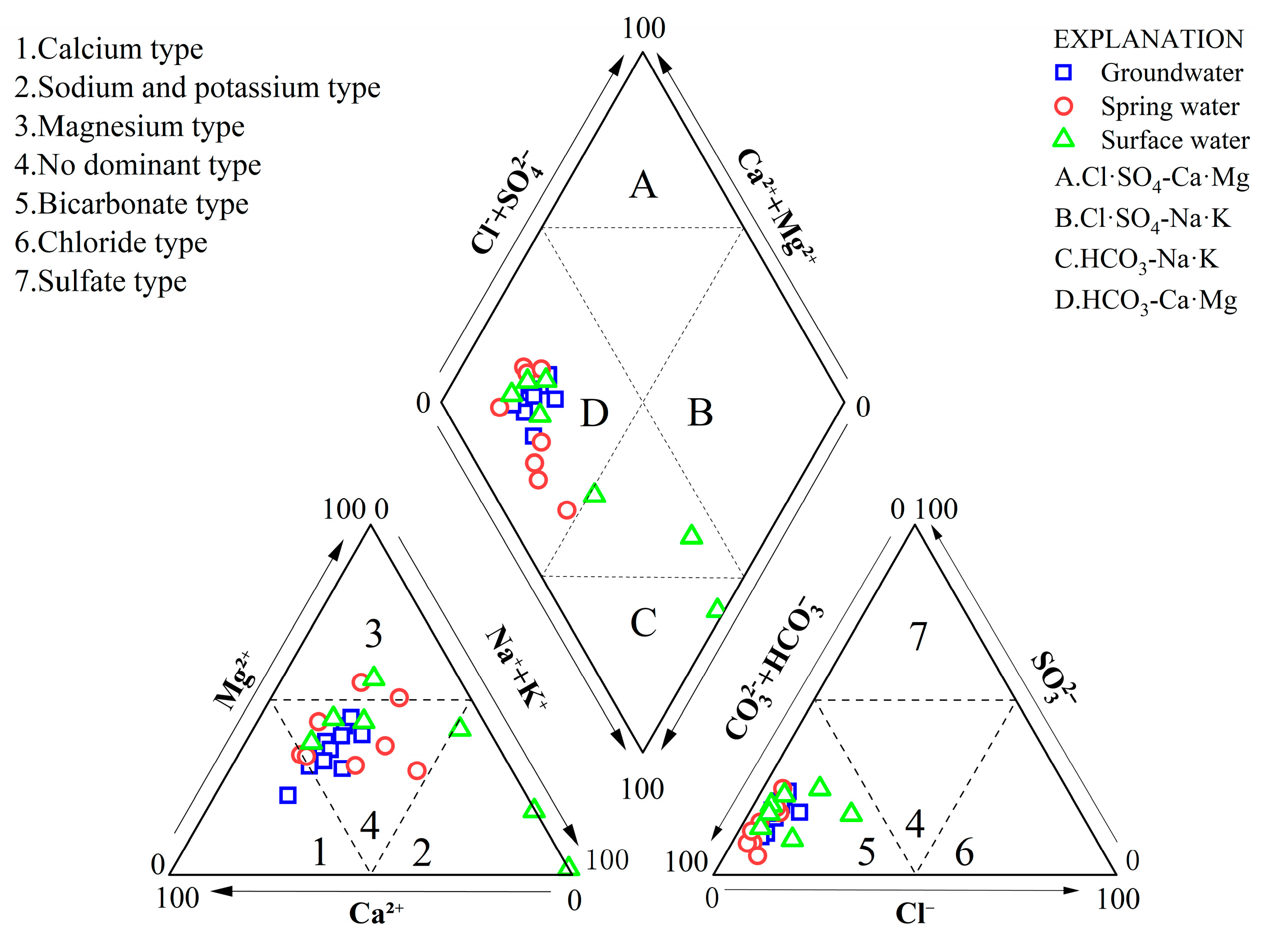
Piper trilinear diagrams are widely used to distinguish hydrochemical water types and to visually identify the dominant ionic composition of water bodies [13,14,15]. The Piper diagram indicates that groundwater, spring water, and most surface-water samples are distributed in relatively concentrated and overlapping fields, suggesting that the three water types share similar hydrochemical characteristics and are all dominated by HCO3 as the principal anion [16]. Groundwater is mainly characterized by Ca2+ as the dominant cation, whereas spring water contains relatively higher proportions of Mg2+ and Na+. Surface water remains generally dominated by Ca·Mg, although a few samples affected more strongly by evaporation concentration show a shift toward the Na+ type. Overall, the differences in hydrochemical type among the three water bodies are minor, reflecting a strong degree of consistency and continuity across the study area.
Using the Shukarev classification, the water samples were categorized by dividing the diamond field of the Piper diagram into four zones, namely A, B, C, and D. Overall, groundwater, spring water, and surface water are all of the HCO3-Ca·Mg type. Only a very few surface-water samples plot in Zone C, where the chemical characteristics are marked by carbonate alkalinity exceeding 50%, and the hydrochemical type is mainly controlled by alkali metals and weak acids. In general, because the hydrological circulation pathways are short and the processes are relatively simple, the hydrochemical types of the three water bodies in the study area do not differ greatly. Combined with the hydrochemical characteristics shown by the Piper diagram (Figure 2), it can be inferred that the overall hydrochemical composition of waters in the study area is primarily controlled by water–rock interaction, while the downstream surface-water sites of the Xianglaqu River are significantly affected by evaporation concentration.
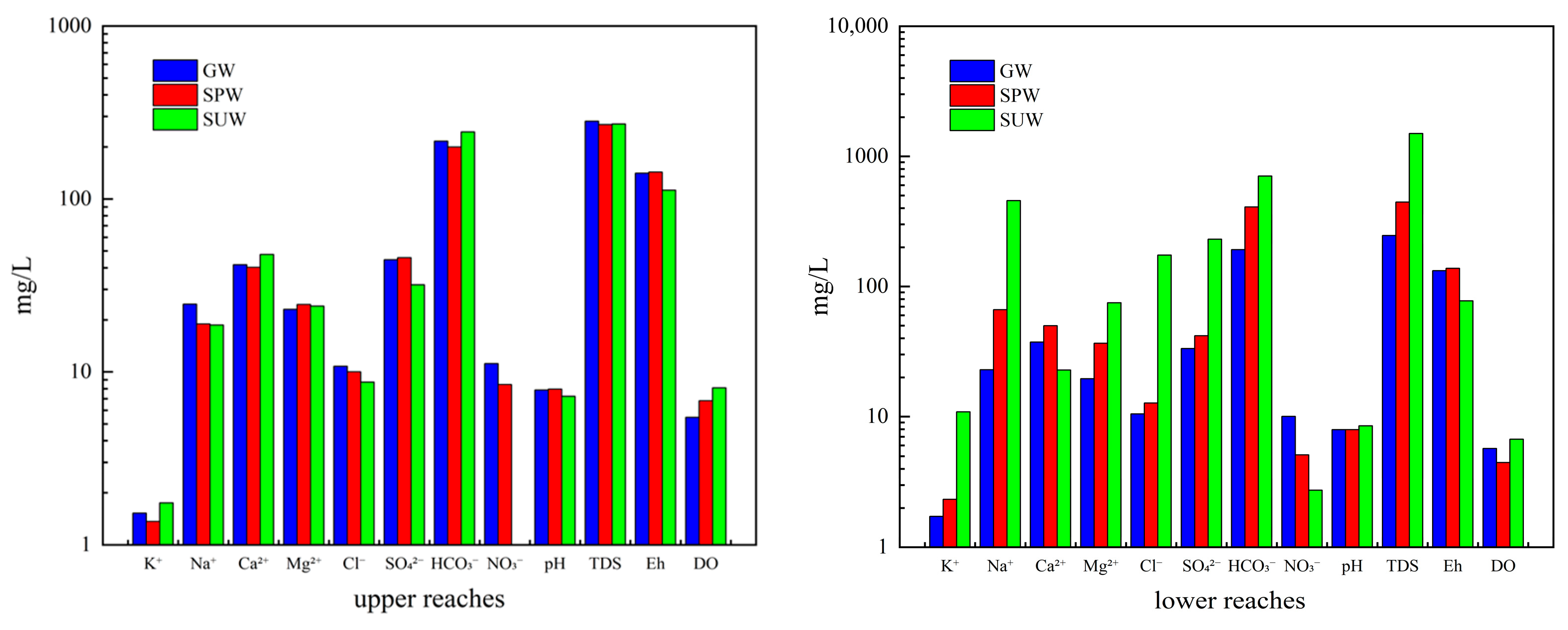
At the regional scale, the concentrations of various ions in the water bodies exhibit pronounced spatial differentiation. In the upstream area, TDS and pH show only minor differences, and all three water types are dominated by Ca2+ and HCO3, with broadly similar ionic compositions. In the downstream area, although pH remains relatively stable, the differentiation in ion concentrations becomes much more pronounced, especially in surface water, where Na+, K+, Cl, SO42−, and HCO3 are significantly higher than those in groundwater and spring water. Overall, these results indicate that the hydrochemical composition of waters in the study area evolves from relatively simple to more complex along the flow direction, accompanied by a trend of solute enrichment, with the most pronounced enrichment occurring in terminal surface water (Figure 3).
Significant differences in ionic concentrations are observed among the various downstream water bodies. Surface water contains much higher concentrations of K+, Na+, Mg2+, Cl, SO42−, and HCO3 than groundwater and spring water, with the greatest differentiation occurring in K+, Na+, Cl, and SO42−.
The Xianglaqu River Basin is a closed endorheic lake-basin system. Groundwater in the mountainous area is mainly stored in local fractured aquifers, laterally flows into the lake basin and valleys where it occurs in Quaternary porous aquifers, and locally emerges as spring water. It then either recharges or discharges into the Xianglaqu River and ultimately drains into Xiagacuo Lake. Therefore, groundwater chemistry is mainly controlled by water–rock interaction and primarily reflects dissolved mineral inputs acquired along local flow paths, whereas basin-scale salt accumulation is not evident.
In contrast, surface water integrates recharge from groundwater, spring water, and hillslope runoff throughout the basin, continuously accumulating ions released by rock weathering and mineral dissolution along the flow path. Under the region’s dry semi-arid-to-arid plateau climate, where evaporation far exceeds precipitation, surface water becomes progressively concentrated as it flows downstream toward Xiagacuo Lake. Because the basin lacks an external drainage outlet, salts are retained and continuously enriched in the water body.
Conservative and highly soluble ions such as K+, Na+, and Cl are not readily removed by precipitation or adsorption and therefore show the strongest enrichment. SO42− is enriched not only by evaporation but also by additional inputs from gypsum dissolution and sulfide oxidation within the basin. By contrast, Ca2+ is more easily removed through carbonate precipitation under conditions of higher pH and HCO3, so its enrichment is less pronounced. Although Mg2+ may also be involved in dolomite precipitation, continued supply from the weathering of Mg-bearing clay minerals makes its enrichment weaker than that of conservative ions.
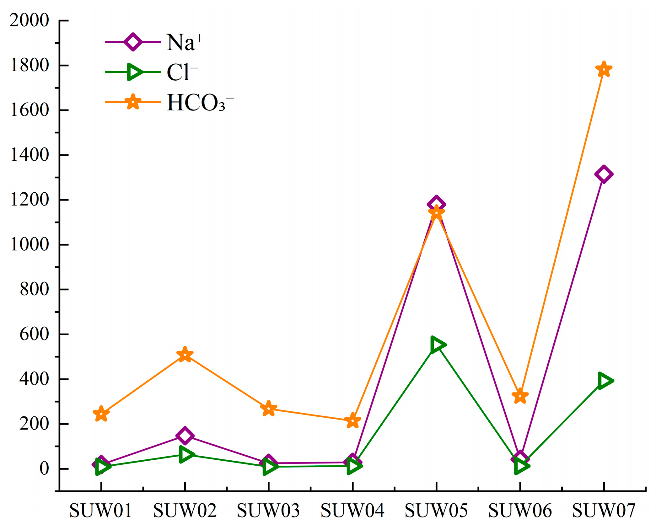
Longitudinal variations in individual surface-water samples show that Na+, Cl, and HCO3 all increase toward the lake, indicating progressive solute accumulation under closed-basin convergence and strong evaporation. Among them, Na+ and Cl show more pronounced enrichment, consistent with the conservative behavior of these ions during terminal concentration, whereas HCO3, although also increasing, is jointly influenced by continued water–rock interaction and by terminal-stage processes such as CO2 degassing and carbonate precipitation. As a result, the relative contribution of HCO3 may decrease in terminal waters even when its absolute concentration still rises (Figure 4).

3.3. Pearson Correlation Analysis

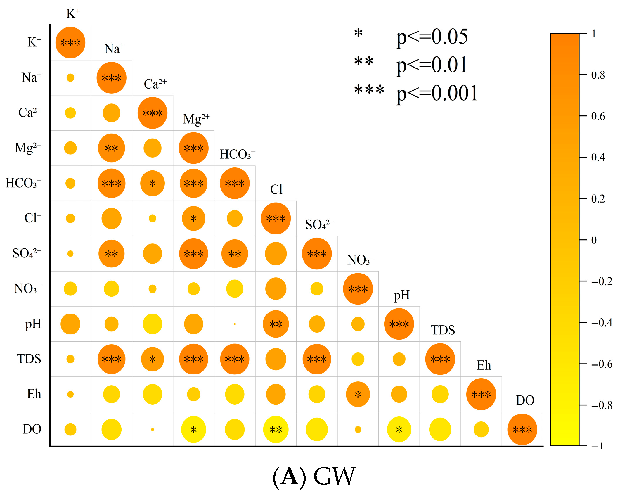
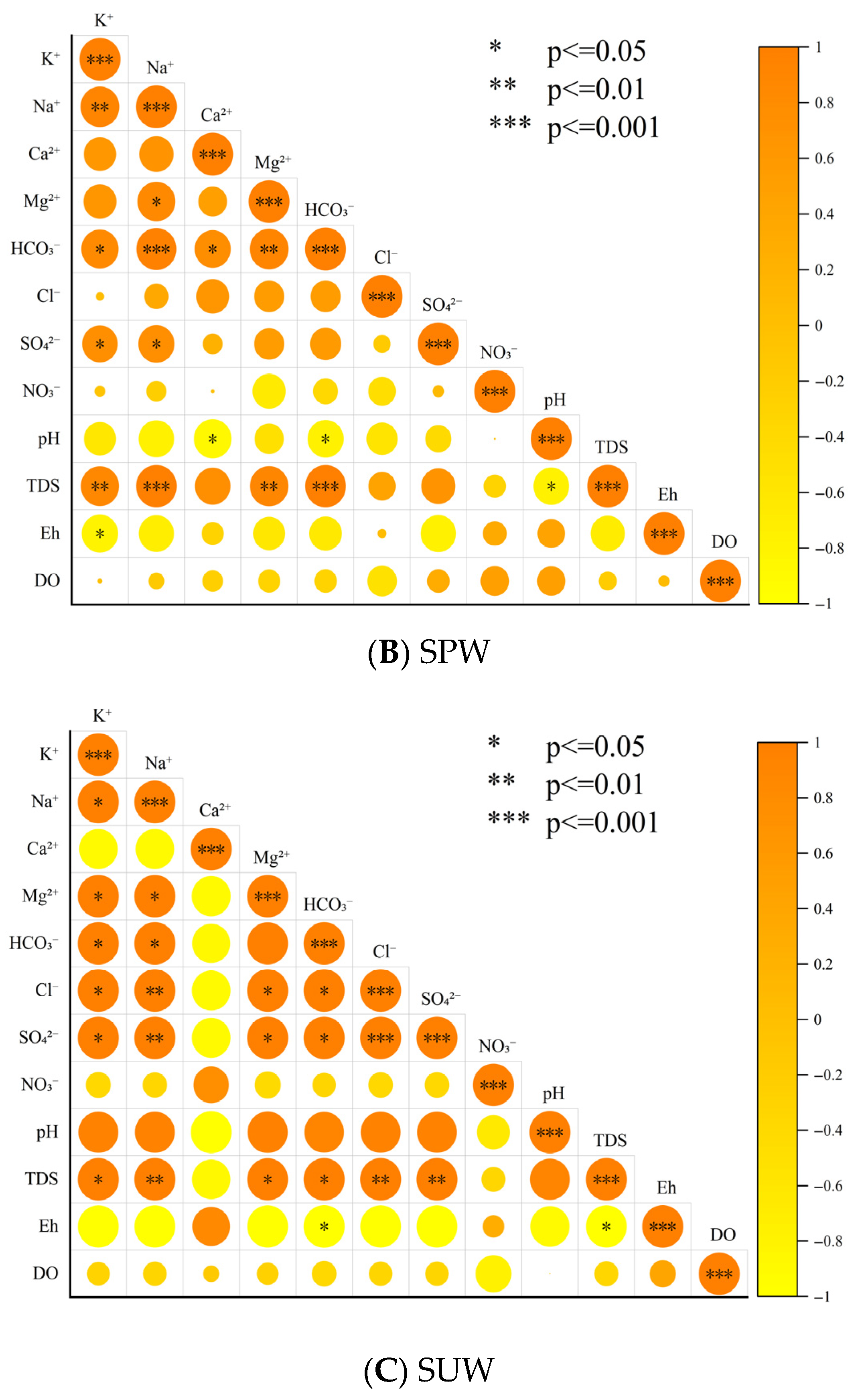
Dissolved oxygen (DO) in groundwater is significantly negatively correlated with Cl and negatively correlated with Mg2+. The relatively low DO and Eh values suggest that groundwater occurs in a comparatively closed environment with weaker oxidation than surface water. Cl and Mg2+ are mainly derived from water–rock interaction processes, including halite dissolution, dolomite weathering, and cation exchange in clay minerals. By contrast, DO is introduced only through atmospheric reoxygenation during recharge and lacks a continuous replenishment source thereafter. It is progressively consumed by microbial respiration and the oxidation of reducing minerals. Thus, more extensive water–rock interaction is associated with stronger ion enrichment and more pronounced DO depletion.
Dissolved oxygen (DO) in groundwater is significantly negatively correlated with Cl and negatively correlated with Mg2+. The relatively low DO and Eh values indicate that groundwater exists in a comparatively closed environment with weaker oxidation conditions than surface water. Cl and Mg2+ are mainly derived from water–rock interactions, including halite dissolution, dolomite weathering, and cation exchange involving clay minerals. In contrast, DO is introduced primarily through atmospheric reoxygenation during recharge and is not subsequently replenished. Instead, it is continuously consumed by microbial respiration and the oxidation of reducing minerals. Therefore, more intense water–rock interaction corresponds to greater ion enrichment and stronger DO depletion.
In surface water, HCO3 is significantly positively correlated with Na+ and K+, indicating that its hydrochemical composition is mainly controlled by silicate weathering and carbonation. During the carbonation of silicate minerals such as feldspars, Na+ and K+ are released simultaneously with the production of HCO3, implying a strongly coupled origin of these ions and highlighting water–rock interaction as the dominant source of major ions in surface water. Meanwhile, SO42− and Cl exhibit an extremely significant positive correlation, suggesting a common external input source (Figure 5). In general, carbonate dissolution, such as the weathering of calcite and dolomite, together with silicate weathering, such as the carbonation of albite and K-feldspar, constitutes the core processes controlling ionic composition, whereas carbonic acid (H2CO3)-mediated dissolution is the principal mechanism driving ion generation in the different water bodies.

4. Discussion

4.1. Controlling Factors of Hydrochemistry

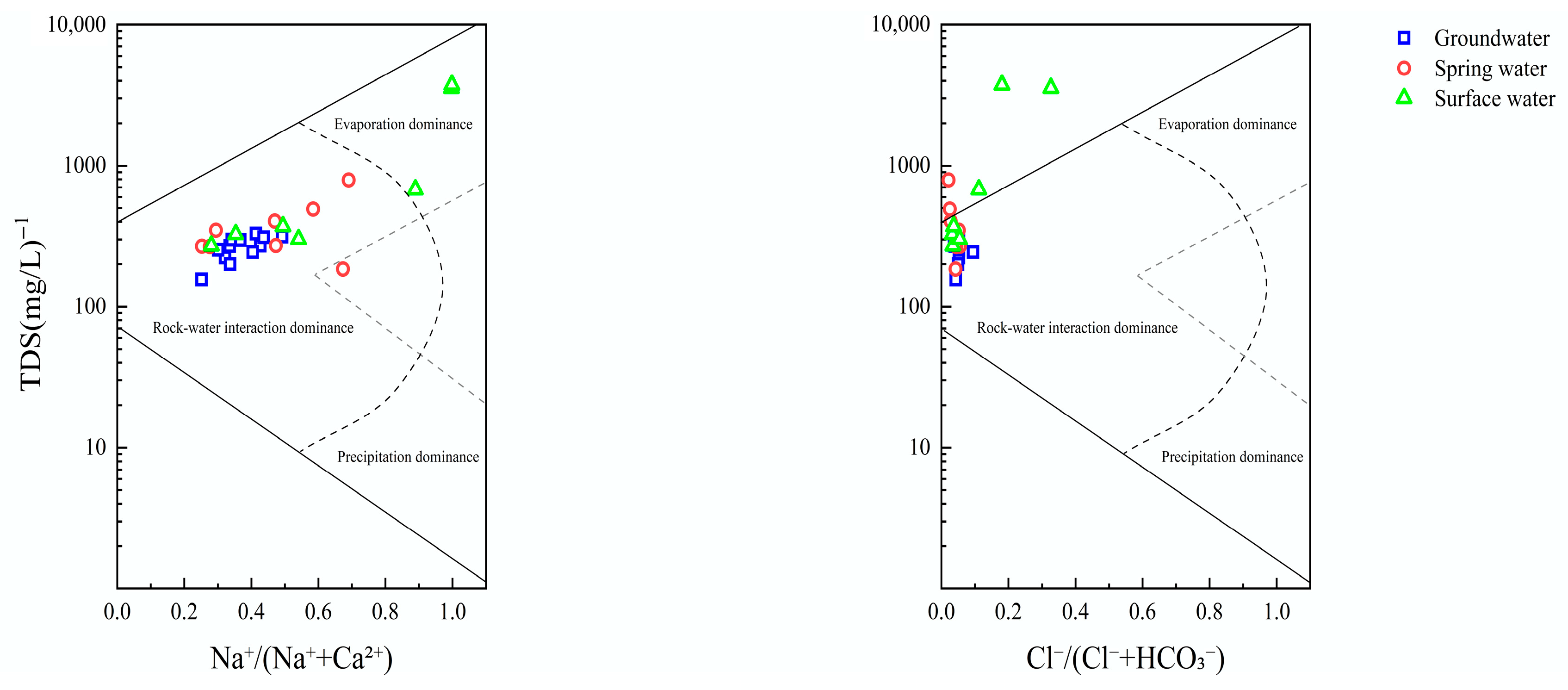
Gibbs diagrams are useful for distinguishing whether water chemistry is mainly controlled by atmospheric precipitation, rock weathering, or evaporation–crystallization [17,18,19]. As shown in Figure 6, groundwater, spring water, and most surface-water samples from the study area fall within the rock-weathering control field, indicating that water–rock interaction is the dominant process controlling basin hydrochemistry. In contrast, the two lake-water samples, SUW05 and SUW07, plot in the evaporation–crystallization control field and show markedly higher TDS values than the other samples, indicating strong solute enrichment. These two samples are located in the downstream terminal lake area of the Xianglaqu River, where surface water converges and groundwater is locally discharged, favoring solute accumulation. In addition, because the basin is endorheic and lacks an external drainage outlet, dissolved salts are readily retained within the system. Under the high-cold arid climatic conditions, strong evaporation further intensifies water loss and salt concentration. Therefore, SUW05 and SUW07 reflect enhanced evaporative concentration in the terminal zone of the basin.

4.2. Ion Ratio Analysis

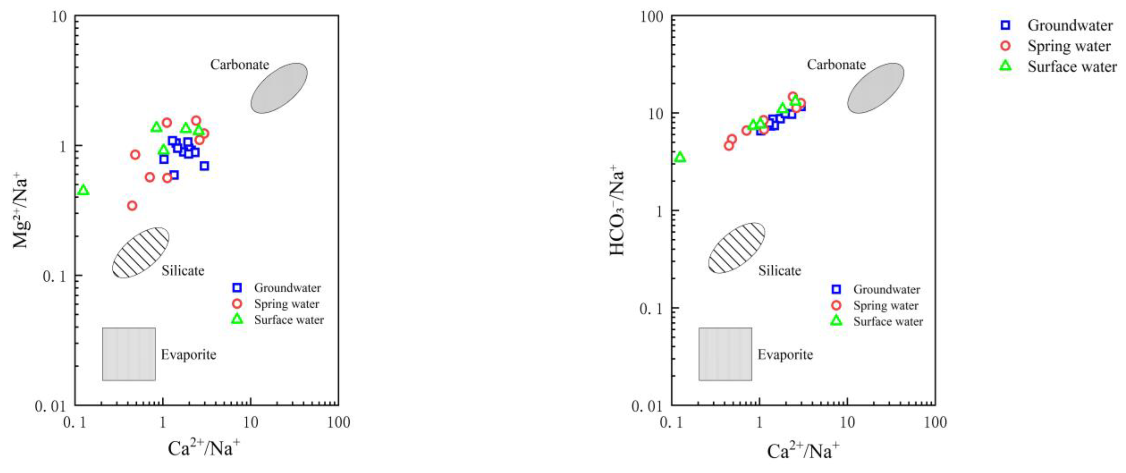
The ion-ratio method uses ionic equivalent concentration ratios (meq/L) to further identify the sources and origins of hydrochemical constituents and to qualitatively assess the influence of rock weathering on groundwater chemistry [20,21]. As shown in Figure 7, the relationships of Ca2+/Na+ versus Mg2+/Na+ and HCO3/Na+ among groundwater, spring water, surface water, and three representative lithologic end-members indicate that most samples plot between the carbonate and silicate end-members. This suggests that dissolved solutes in the study area are derived mainly from the weathering of carbonate and silicate rocks, whereas evaporites are not the dominant source at the regional scale [22]. Compared with groundwater, some spring-water samples from the central basin plot closer to the silicate end-member, implying a locally stronger influence of silicate weathering on spring-water chemistry.
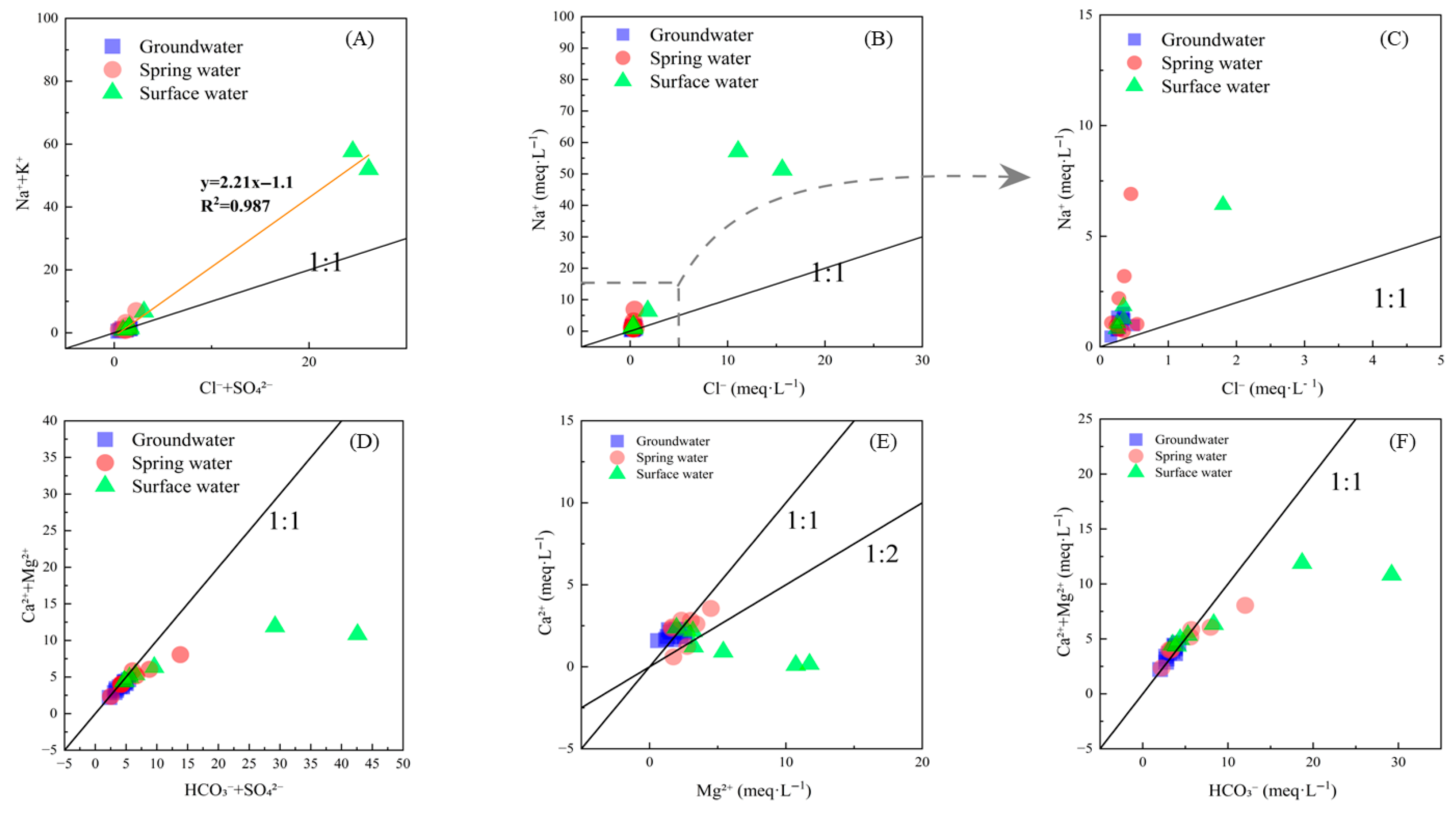
The ion-ratio plots in Figure 8 show that the fitted relationship for (Na+ + K+)/(Cl + SO42−) in groundwater, spring water, and surface water from the Xianglaqu River Basin is y = 2.21x − 1.1 (R2 = 0.987). Except for two samples strongly influenced by evaporation concentration, most samples have (Na+ + K+)/(Cl + SO42−) ratios close to 1 (Figure 8A), suggesting a common source of these ions. This consistency implies similar solute sources and hydrochemical evolution among the three water types and supports a close hydraulic connection between surface water and groundwater. Although Cl and SO42− are commonly associated with evaporite dissolution, evaporites are scarce in the basin, indicating that K+ and SO42− in river water and groundwater are more likely derived mainly from silicate weathering and dissolution [23].Moreover, most samples plot near the 1:1 line for (Ca2+ + Mg2+)/(HCO3 + SO42−), with only a few falling below it (Figure 8D), indicating that carbonate dissolution dominates in the basin, whereas silicate weathering exerts only a minor influence at a few sites.
As shown in Figure 8B,C, most samples plot close to the theoretical 1:1 line for Na+/Cl, with only two samples showing obvious deviation. The near-1:1 relationship suggests that some samples may have been influenced by local saline-mineral dissolution. However, combined with the end-member diagrams, the overall hydrochemistry of the study area is still interpreted to be controlled mainly by carbonate and silicate weathering, rather than by evaporites. The Na+ enrichment in the deviating samples is attributed partly to strong evaporative concentration at SUW05 and SUW07, which elevates the concentrations of all ions, and partly to enhanced dissolution of silicate minerals such as albite and K-feldspar in silty shale or quartz siltstone near the sampling sites. Such dissolution may preferentially release Na+ and thus disturb the Na+–K+ balance. In general, basin hydrochemistry is dominated by carbonate–silicate weathering, with evaporative concentration and minor evaporite dissolution superimposed only at local or terminal sites.
Figure 8E shows that most groundwater and spring-water samples cluster near the theoretical 1:1 Ca2+/Mg2+ line, suggesting that carbonate weathering, particularly dolomite dissolution, exerts an important control on their hydrochemical composition. In contrast, several surface-water samples deviate from this line and plot toward relative Mg2+ enrichment (Ca2+ < Mg2+), indicating that their Ca2+/Mg2+ ratios are no longer controlled solely by simple dolomite dissolution. This deviation is more likely the result of multiple processes acting during downstream evolution. On the one hand, longer flow paths and stronger interaction with silty shale and other Mg-bearing lithologies may enhance the weathering of clay minerals and silicate phases, thereby providing additional Mg2+ to surface water. On the other hand, cation exchange may promote relative Ca2+ depletion through the removal of Ca2+ from solution and the release of Mg2+ and/or Na+ from the solid phase. In addition, under downstream alkaline conditions, preferential removal of Ca2+ by carbonate precipitation may further strengthen this offset. Therefore, the departure of some surface-water samples from the 1:1 line reflects the combined effects of water–rock interaction, cation exchange, and downstream hydrochemical evolution, rather than a single dissolution process.
Theoretically, the molar ratio of (Ca2+ + Mg2+)/HCO3 is 1/2. However, the (Ca2+ + Mg2+)/HCO3 plot (Figure 8F) shows that most samples deviate from the theoretical relationship for simple carbonate dissolution, indicating that hydrochemical evolution in the study area is governed by multiple processes rather than a single control. These processes likely include carbonate weathering, silicate weathering, evaporation concentration, and ion exchange. Some surface-water samples show distribution patterns distinct from those of groundwater and spring water, suggesting differences in environmental setting and hydrochemical evolution among water types. Combined analysis of Figure 8E,F shows that several samples with excess alkalinity are marked by Ca2+ depletion and Mg2+ enrichment, a pattern more consistent with cation exchange than with simple calcite precipitation. In addition to carbonate and silicate weathering, cation exchange is therefore an important control on the hydrochemical evolution of some waters in the study area. Overall, these patterns suggest that basin hydrochemistry results from the coupled effects of carbonate dissolution, HCO3 degassing and precipitation, cation exchange in clay minerals, and silicate dissolution, while also clearly indicating environmental differentiation among water bodies. Samples near the 1:1 line correspond to relatively stagnant groundwater and spring-water settings, whereas those below the line represent open-flow surface-water environments.

4.3. PHREEQC-Based Verification of Solute Sources

To further verify the sources of solutes and the hydrogeochemical evolution of basin waters from the perspective of thermodynamic equilibrium between mineral dissolution and precipitation, PHREEQC was used to calculate the saturation indices (SIs) of typical minerals in groundwater (GW), spring water (SPW), and surface water (SUW) in the basin [24,25]. An SI value greater than 0 indicates supersaturation and a thermodynamic tendency toward mineral precipitation, whereas an SI value less than 0 indicates undersaturation and the potential for continued mineral dissolution [26,27]. The calculated results are shown in Table 2.
The saturation index (SI) results show clear differences among water types in the Xianglaqu River Basin. Calcite and aragonite are generally close to saturation or slightly oversaturated in most samples (Table 2). Their median SI values increase from groundwater (0.21 and 0.06, respectively) to spring water (0.43 and 0.28) and surface water (0.55 and 0.41), indicating progressively stronger carbonate saturation along the flow path. Dolomite shows greater variability, but spring water and surface water are generally oversaturated, with median SI values of 1.10 and 1.61, respectively, whereas groundwater shows strong internal heterogeneity. In contrast, halite is strongly undersaturated in all water types, with median SI values ranging from −8.13 to −7.85, indicating that halite precipitation is unlikely under present hydrochemical conditions. Gypsum is also undersaturated in groundwater and spring water, with median SI values of −2.12 and −2.13, but surface water shows much higher SI values, with a maximum of 3.57 and a median of 1.61, suggesting that evaporative concentration significantly enhances sulfate mineral saturation in terminal waters.

5. Conclusions

In this study, we reached the following conclusions:
  • The Xianglaqu Basin, an important recharge area of a typical endorheic lake basin in the Tibetan Plateau, shows overall hydrochemical continuity among groundwater, spring water, and surface water. Most samples are predominantly of the HCO3–Ca·Mg type, whereas downstream and terminal surface waters show marked increases in Na+, Cl, SO42−, and TDS, with some samples evolving toward HCO3–Na facies. This pattern reflects progressive solute accumulation and terminal enrichment in the closed basin.
  • Hydrochemical evolution is controlled mainly by water–rock interaction, with carbonate weathering being the dominant source of major ions and silicate weathering as an important supplementary process. Evaporation concentration, local saline-mineral dissolution, and cation exchange further affect some waters, especially in downstream and terminal zones. Saturation-index results support this interpretation, showing increasing carbonate saturation along the flow path, persistent halite undersaturation, and enhanced gypsum saturation in terminal surface water.
  • The systematic spatial evolution and overall compositional similarity among the three water types suggest hydrochemical continuity within the basin-scale shallow flow system and likely surface water–groundwater linkage. Overall, hydrochemical evolution in the Xianglaqu Basin can be summarized as local weathering release, along-path solute accumulation, and terminal evaporative enrichment. These findings provide useful references for understanding salinization processes, water-resource assessment, solute migration identification, and environmental monitoring in similar alpine arid endorheic basins.

Author Contributions

Conceptualization, S.H.; Methodology, S.H. and G.Y.; Software, S.H.; Validation, S.H.; Formal analysis, S.H.; Investigation, S.H., Y.Q., S.Z., W.L. and W.C.; Data curation, S.H.; Writing—original draft, S.H. and Y.Q.; Writing—review & editing, S.H. and Y.Q.; Visualization, S.H.; Supervision, Y.Q.; Project administration, Y.Q., S.Z., C.G., C.Y., W.L. and W.C.; Funding acquisition, Y.Q. All authors have read and agreed to the published version of the manuscript.

Funding

China’s Land and Resources Survey Project, No. DD20230423.

Data Availability Statement

The original contributions presented in this study are included in the article. Further inquiries can be directed to the corresponding author.

Acknowledgments

We would like to thank the anonymous reviewers and editors for their constructive comments on this manuscript.

Conflicts of Interest

The authors declare no conflicts of interest.

References

  1. Zhang, J.Y.; Xie, K.; Jin, J.L.; Li, D.; Wang, G.Q.; Liu, C.S.; Liu, Y.L.; Bao, Z.X.; Ma, T.; He, R.M. Runoff variations on the Tibetan Plateau: Analysis and discussion. Adv. Water Sci. 2025, 36, 907–916. (In Chinese) [Google Scholar] [CrossRef]
  2. Appelo, C.A.J.; Postma, D. Geochemistry, Groundwater and Pollution; CRC Press: Boca Raton, FL, USA, 2004. [Google Scholar]
  3. Zhao, N.Y.; Zhou, J.L.; Jiang, F.; Ding, Q.Z. Chemical characteristics and influencing factors of groundwater in the plain area of Tizinafu River Basin, Xinjiang. South-to-North Water Transf. Water Sci. Technol. 2025, 23, 421–432. (In Chinese) [Google Scholar] [CrossRef]
  4. Jin, Z.C.; Wang, S.Y.; He, X.B.; Wu, Y.Q.; Ding, Y.J. Hydrochemical Characteristics and Controlling Factors of River Water in the Buqu River Basin, Source Region of the Yangtze River. Acta Geogeraphica Sin. 2025, 80, 2450–2467. (In Chinese) [Google Scholar] [CrossRef]
  5. Sheng, H.B.; Teng, Y.; Zhang, W.Q.; Gao, Z.J.; Dou, B.; Liu, W. Hydrochemical characteristics and pollution source analysis of groundwater in the Futuan River Basin of Rizhao City. Tianjin Norm. Univ. (Nat. Sci. Ed.) 2025, 45, 50–59. [Google Scholar] [CrossRef]
  6. Wei, X.; Yu, Y.L.; Li, W.Y.; Lyu, C.; Huo, W. Hydrochemistry and isotopic characteristics of Guishui River Basin and their indicative significance. Environ. Sci. Technol. 2024, 47, 135–145. [Google Scholar] [CrossRef]
  7. Piper, A.M. A graphic procedure in the geochemical interpretation of water analyses. Eos Trans. Am. Geophys. Union. 1944, 25, 914–928. [Google Scholar] [CrossRef] [Scilit]
  8. Gibbs, R.J. Mechanisms controlling world water chemistry. Science 1970, 170, 1088–1090. [Google Scholar] [CrossRef] [Scilit] [PubMed]
  9. He, B.Y. Hydrogeochemical Characteristics and Groundwater Discharge in the Buha River Basin of Qinghai Lake. Master’s thesis, University of Chinese Academy of Sciences (Qinghai Institute of Salt Lakes, Chinese Academy of Sciences), Xining, China, 2022. [Google Scholar]
  10. Han, S.B.; Zhou, Y.Z.; Zheng, Y.; Zhou, J.-L.; Li, C.-Q.; Han, Q.-Q.; Li, F.-C. Formation mechanism and source apportionment of hydrochemical components in groundwater in the Yinchuan Plain. Environ. Sci. 2024, 45, 4577–4588. [Google Scholar] [CrossRef] [Scilit]
  11. Xu, D.Q. Studies on the Characteristics and Controlling Factors of Hydrochemical Evolution in Suxian Mining Area. Master’s thesis, Hefei University of Technology, Hefei, China, 2017. [Google Scholar]
  12. Hao, Y.R.; Wang, P.; Zhang, M.Z.; Zhang, J.; Li, D.; Pang, Y. Hydrochemical characteristics and its driving force of groundwater in the covered karst in Pearl River Basin. Ecol. Environ. Sci. 2020, 29, 337–344. [Google Scholar] [CrossRef]
  13. Liu, J.; Peng, Y.; Li, C.; Gao, Z.; Chen, S. Characterization of the hydrochemistry of water resources of the Weibei Plain, Northern China, as well as an assessment of the risk of high groundwater nitrate levels to human health. Environ. Pollut. 2021, 268, 115947. [Google Scholar] [CrossRef] [Scilit]
  14. Li, Z.; Li, C.X.; Hua, K.; Li, Z. Groundwater chemistry characteristics and analysis of influencing factors in the Luochuan Loess Tablelands. Environ. Sci. 2019, 40, 3559–3567. [Google Scholar] [CrossRef]
  15. Ren, X.Z.; Yang, X.P. Hydrochemical composition and genesis of natural waters in the Ordos Sandy Region. Acta Geogr. Sin. 2021, 76, 2224–2239. (In Chinese) [Google Scholar] [CrossRef]
  16. Shi, L.Q.; Shi, Y.D.; Qiu, M.; Guo, Z.A.; Yang, J.F.; Jiang, H.B. Identification of fault water source based on Piper diagram, grey correlation degree and 3D high-density electric method. Chin. Sci. Pap. 2022, 17, 1. [Google Scholar] [CrossRef]
  17. Galy, A.; France-Lanord, C. Weathering processes in the Ganges–Brahmaputra Basin and the riverine alkalinity budget. Chem. Geol. 1999, 159, 31–60. [Google Scholar] [CrossRef] [Scilit]
  18. Li, J.; Zhou, Y.Z.; Zhou, J.L.; Sun, Y.; Zeng, Y.; Ding, Q. Hydrogeochemical evidence for fluoride sources and enrichment in desert groundwater: A case study of Cherchen River Basin, northwestern China. Contam. Hydrol. 2023, 259, 104270. [Google Scholar] [CrossRef] [Scilit]
  19. Marandi, A.; Shand, P. Groundwater chemistry and the Gibbs diagram. Appl. Geochem. 2018, 97, 209–212. [Google Scholar] [CrossRef] [Scilit]
  20. Gong, Y.B.; Gong, X.L.; Xu, S.G.; Tang, X.; Su, D.; Wu, X. Hydrochemical characteristics and evolution of groundwater in Southern Jiangsu. Geol. Rev. 2022, 68, 2207–2218. (In Chinese) [Google Scholar] [CrossRef]
  21. Jin, A.F.; Yin, X.L.; Li, C.Q.; Li, W.J.; Pang, J.M.; Jin, X.M. Hydrochemical characteristics and genesis mechanism of groundwater in the dry period in the Zhangjiakou area. Environ. Sci. 2024, 45, 826–836. [Google Scholar] [CrossRef] [Scilit]
  22. Wu, C.; Xuan, Y.X.; Zhang, H.; Dun, Y.; Wu, G.; Cao, Y. Groundwater hydrochemical characteristics and cause analysis in an arid and semi-arid area. South-to-North Water Transf. Water Sci. Technol. 2022, 20, 525–535. (In Chinese) [Google Scholar] [CrossRef]
  23. Xiao, J.; Jin, Z.; Zhang, F.; Wang, J. Major ion geochemistry of shallow groundwater in the Qinghai Lake catchment, NE Qinghai-Tibet Plateau. Environ. Earth Sci. 2012, 67, 1331–1344. [Google Scholar] [CrossRef] [Scilit]
  24. Ahusborde, E.; Tabrizinejadas, S. A sequential approach for multiphase reactive transport: Coupling PHREEQC with hydrological modeling. Environ. Earth Sci. 2025, 84, 564. [Google Scholar] [CrossRef] [Scilit]
  25. Parkhurst, D.L.; Appelo, C.A.J. Description of Input and Examples for PHREEQC Version 3: A Computer Program for Speciation, Batch-Reaction, One-Dimensional Transport, and Inverse Geochemical Calculations; U.S. Geological Survey: Reston, VA, USA, 2013. [Google Scholar]
  26. Cai, P.; Yan, H.; Sedighi, M.; Jivkov, A.; Xiong, Q.; Wang, H. Peridynamic theory coupled with PHREEQC for reactive transport modeling in heterogeneous and discontinuous porous media. Comput. Geotech. 2025, 188, 107579. [Google Scholar] [CrossRef] [Scilit]
  27. Zhang, J.; Coker, V.S.; Mosselmans, J.F.W.; Goût, T.L.; de Carvalho, L.A.B.; Shaw, S. Insights from XAS, FTIR, and PHREEQC into mono- and poly-vanadate (V(V)O43−) adsorption to Hematite. Chem. Geol. 2026, 702, 123228. [Google Scholar] [CrossRef] [Scilit]
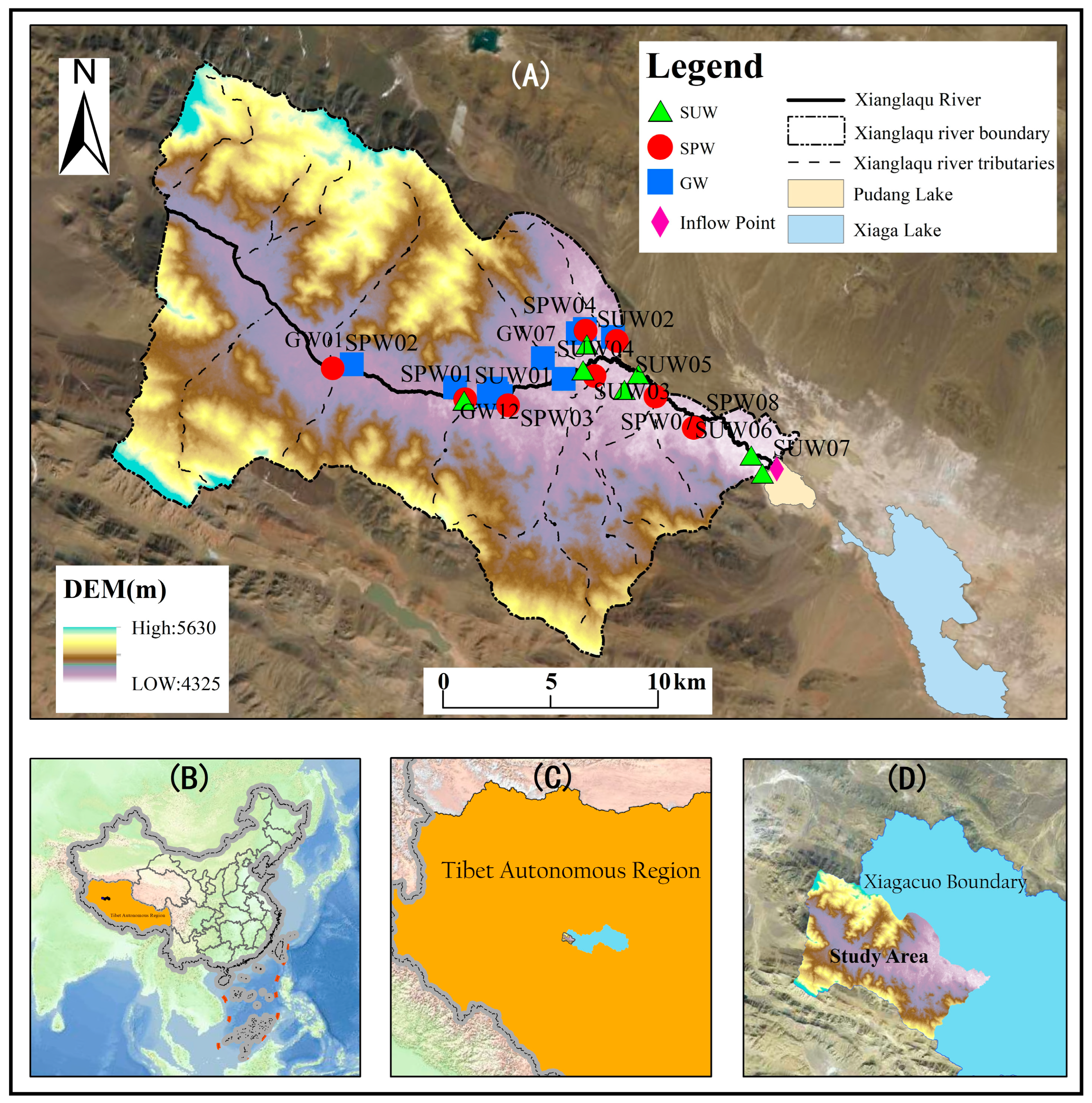
Figure 1. Location of the study area and distribution of sampling points.
Water 18 01180 g001
Figure 2. Piper diagram of water samples in the study area.
Water 18 01180 g002
Figure 3. Bar Chart of Ion Concentrations in Water Samples from Upstream and Downstream Reaches.
Water 18 01180 g003
Figure 4. Along-flow variation in Na+, Cl, and HCO3 among individual surface-water sampling sites.
Water 18 01180 g004
Figure 5. Correlation analysis among hydrochemical parameters in the study area.
Water 18 01180 g005aWater 18 01180 g005b
Figure 6. Gibbs diagrams of water samples in the study area.
Water 18 01180 g006
Figure 7. Endmember diagram of ion proportions of water samples in the study area.
Water 18 01180 g007
Figure 8. Ion ratio relationship diagram of all sampling sites in the study area.
Water 18 01180 g008
Table 1. Hydrochemistry statistical characteristic of Xianglaqu River Basin.
NameStatisticsK+Na+Ca2+Mg2+HCO3Cl
GWMax3.0035.3445.8931.22255.7017.46
Min0.8810.7532.017.47125.10 5.59
Mean1.6323.7539.5221.27203.7310.62
SD0.517.005.197.0138.802.89
CV0.320.29 0.13 0.330.190.27
SPWMax4.42159.0071.33 54.69733.4019.21
Min0.3116.4512.1619.72134.905.94
Mean1.9748.5646.2732.06330.1311.70
SD1.4348.7718.9412.27198.814.30
CV0.721.000.410.380.600.37
SUWMax26.401314.0047.76 142.601782.00553.60
Min1.75 18.65 2.01 24.01 213.60 8.73
Mean9.56 393.72 26.32 67.66 640.04 150.38
SD10.23 585.84 19.49 48.85 598.58 226.23
CV1.07 1.49 0.74 0.72 0.94 1.50
NameStatisticsSO42−NO3pHTDSEhDO
GWMax60.96 15.63 8.16 330.00 191.40 6.55
Min13.12 7.56 7.71 156.00 104.20 3.45
Mean38.92 10.59 7.89 263.92 144.17 5.11
SD15.14 2.44 0.13 51.71 22.66 1.05
CV0.39 0.23 0.02 0.20 0.16 0.21
SPWMax86.24 13.14 8.90 792.00 196.70 8.26
Min14.73 1.46 7.25 185.00 42.40 3.92
Mean43.26 6.02 7.94 378.75 120.38 6.20
SD22.65 4.17 0.49 192.30 53.44 1.45
CV0.52 0.69 0.06 0.51 0.44 0.23
SUWMax643.90 5.04 9.42 3740.00 121.00 8.08
Min31.84 1.26 7.22 271.00 52.10 5.68
Mean202.11 2.74 8.30 1320.57 91.27 6.72
SD257.71 2.02 0.77 1595.91 27.60 0.89
CV1.28 0.74 0.09 1.21 0.30 0.13
Table 2. Summary of Saturation Indices for Different Water Bodies in the Basin.
NameStatisticsCalciteDolomiteGypsumHaliteAragonite
GWMax0.38 8.98 −2.03 −7.92 0.23
Min−0.21 −2.65 −2.66 −8.75 −0.36
Median0.21 −2.57 −2.12 −8.13 0.06
Mean0.18 0.30 −2.22 −8.18 0.03
SPWMax0.66 1.54 −1.79 −7.18 0.52
Min0.00 −0.11 −3.06 −8.36 −0.15
Median0.43 1.10 −2.13 −8.07 0.28
Mean0.39 0.91 −2.23 −7.97 0.24
SUWMax0.78 3.57 3.57 −4.85 0.64
Min−0.28 −0.56 −0.56 −8.34 −0.42
Median0.55 1.61 1.61 −7.85 0.41
Mean0.41 1.67 1.67 −6.98 0.27
Disclaimer/Publisher’s Note: The statements, opinions and data contained in all publications are solely those of the individual author(s) and contributor(s) and not of MDPI and/or the editor(s). MDPI and/or the editor(s) disclaim responsibility for any injury to people or property resulting from any ideas, methods, instructions or products referred to in the content.