Article

Modeling the River Health and Environmental Scenario of the Decaying Saraswati River, West Bengal, India, Using Advanced Remote Sensing and GIS

1
Department of Earth Sciences and Remote Sensing, JIS University, Kolkata 700109, West Bengal, India
2
Department of Geography and Environmental Sustainability, College of Humanities and Social Sciences, Princess Nourah bint Abdulrahman University, P.O. BOX 84428, Riyadh 11671, Saudi Arabia
3
Amity Institute of Geoinformatics and Remote Sensing (AIGIRS), Amity University, Sector 125, Noida 201313, Uttar Pradesh, India
4
Public Works Engineering Department, Faculty of Engineering, Mansoura University, Mansoura 35516, Egypt
*
Author to whom correspondence should be addressed.
Water 2025, 17(7), 965; https://doi.org/10.3390/w17070965
Submission received: 1 February 2025 / Revised: 21 March 2025 / Accepted: 24 March 2025 / Published: 26 March 2025

Abstract

:
This study assesses the environmental status and water quality of the Saraswati River, an ancient and endangered waterway in Bengal, using an integrated approach. By combining traditional knowledge, advanced geospatial tools, and field analysis, it examines natural and human-induced factors driving the river’s degradation and proposes sustainable restoration strategies. Tools such as the Garmin Global Positioning System (GPS) eTrex10, Google Earth Pro, Landsat imagery, ArcGIS 10.8, and Google Earth Engine (GEE) were used to map the river’s trajectory and estimate its water quality. Remote sensing-derived indices, including the Normalized Difference Water Index (NDWI), Modified Normalized Difference Water Index (MNDWI), Normalized Difference Salinity Index (NDSI), Normalized Difference Turbidity Index (NDTI), Floating Algae Index (FAI), and Normalized Difference Chlorophyll Index (NDCI), Total Dissolved Solids (TDS), were computed to evaluate parameters such as the salinity, turbidity, chlorophyll content, and water extent. Additionally, field data from 27 sampling locations were analyzed for 11 critical water quality parameters, such as the pH, Total Dissolved Solids (TDS), Electrical Conductivity (EC), Dissolved Oxygen (DO), Biochemical Oxygen Demand (BOD), and microbial content, using an arithmetic weighted water quality index (WQI). The results highlight significant spatial variation in water quality, with WQI values ranging from 86.427 at Jatrasudhi (indicating relatively better conditions) to 358.918 at Gobra Station Road (signaling severe contamination). The pollution is primarily driven by urban solid waste, industrial effluents, agricultural runoff, and untreated sewage. A microbial analysis revealed the presence of harmful species, including Escherichia coli (E. coli), Bacillus, and Entamoeba, with elevated concentrations in regions like Bajra, Chinsurah, and Chandannagar. The study detected heavy metals, fertilizers, and pesticides, highlighting significant anthropogenic impacts. The recommended mitigation measures include debris removal, silt extraction, riverbank stabilization, modern hydraulic structures, improved waste management, systematic removal of water hyacinth and decomposed materials, and spoil bank design in spilling zones to restore the river’s natural flow.

1. Introduction

Surface water (rivers, ponds, lakes, reservoirs) fulfils water needs in domestic, agricultural, and industrial fields [1,2]. People are more concerned about surface water quality nowadays. The main polluting agents come from industrial and municipal wastewater, as well as pesticides and fertilizers from agricultural fields [3]. Organic pollutants come from solid waste, crops, and food waste [4]. Microbial contents come from decomposing dead human and animal bodies [5]. Phosphorus and nitrogen come to the river from detergents and fertilizers, which are responsible for algal and phytoplankton growth that causes eutrophication [6]. Determining the causes and sources of pollution in a river is very important [7]. In this research, we are concerned about the river Saraswati, which has importance in the history of Bengal. It is a distributary of the Bhagirathi Hooghly River. At present, this river is a dead river. Notably, it was an important river in West Bengal in the far past, that is, during the time span from the 13th to 17th centuries [8]. However, due to the partitioning of Bhagirathi in the 17th century, and mainly because of the construction of the Damodar Valley Corporation canal, the water supply in this river has decreased and the amount of sediment in this river has increased. This has caused the river to dry up [9]. At present, the channel is dry in most parts, but that portion of the Saraswati River which is attached to the Hooghly River, and its adjoining areas, contains water. The river now extends from Triveni town in Hooghly district to Sankrail town in Howrah district [10]. The river flows through Triveni, Mogra, Adisaptagram, Debanandapur, Bandel, Chinsurah, Chandannagar, Mankundu, Singur, Nasibpur, Baruipara, Dankuni, Domjur, Andul, and Sankrail. The current length of the river is about 79.4 km. With the progress of civilization, the river is constantly being damaged by anthropogenic activities [11]. The present condition of the river is very poor, and the river must be given special maintenance attention, both for its rejuvenation and for the well-being of that percentage of the population that use the river water for their day-to-day activities. Presently, the river is used as a dumping site. This makes the water unhygienic for human and animal use. Apart from this, the construction of buildings for both trade and living on the bank of the river adds to the volume of waste material being dumped into the river and is a threat to the river becoming choked. A study on the geography of the Saraswati Basin provides an example of how a large river has been destroyed by the interaction of physical and cultural forces and has become moribund in subsequent stages.
A significant component of the research involves depicting the current environmental scenario and investigating how both natural and anthropogenic factors contribute to the river’s degradation. By understanding these influences, this study endeavors to recommend sustainable solutions to counter the ongoing deterioration. However, this objective presents numerous challenges. In several locations, the river is so severely degraded that its channel is barely discernible. This makes it difficult to trace its historical course or study its current state. Accessibility issues further exacerbate the problem, as many areas within the river basin are hard to reach, posing logistical difficulties for field investigations.
River ecology is an emerging scientific field focusing on the ecological dynamics of rivers, with GIS and remote sensing (RS) playing a crucial role in studying river ecosystems, including land use, vegetative dynamics, deforestation, and water quality monitoring [12]. In China, RS methods for water quality evaluation rely on ground object spectrometers to track water color indicators such as chlorophyll-a and suspended solids, with semi-empirical methods being commonly used for data inversion [13]. Addressing water pollution, RS facilitates calculations of turbidity, total suspended solids (TSS), and chlorophyll-A through indices like the Normalized Difference Turbidity Index (NDTI) and Normalized Difference Chlorophyll Index (NDCI), enabling efficient and rapid assessments [14]. Remote sensing-based ecological indices (RSEIs) have been used in the Erhai Lake Basin to analyze ecological changes from 1999 to 2019, revealing trends of ecological decline and recovery linked to urbanization and tourism, with spatial patterns confirmed using Global Moran’s I values [15]. Similarly, in the Middle Yangtze River Basin, GEE-based analyses utilized Landsat data and cloud removal techniques to calculate water extent variations, achieving classification accuracies between 86% and 93% [16]. In the Thirumanimuthar River Basin, RS methods employing Landsat 5 TM data accurately retrieved water quality parameters such as algae, turbidity, and nutrient concentrations, demonstrating strong correlations with ground measurements for slightly polluted waters [17]. Remote sensing’s transformative role in monitoring pollutants, including chemical, physical, and biological contaminants, was further highlighted through a systematic review of 132 studies using multispectral and hyperspectral imaging, machine learning, and statistical models [18]. In the Hudson River, Landsat 8 OLI-TIRS data combined with AI models like MARS and GEP were used to effectively estimate the WQI, showcasing the potential of satellite imagery and AI for resource-efficient monitoring [19]. Additionally, in the Ebinur Lake Basin, RS techniques revealed poor water quality with a WQI of 4000, and the spectral derivative method enhanced the correlation between water reflectivity and the WQI, supporting the integration of multi-source spectral data for accurate assessments in arid regions [20].
Multi-criteria-based modeling is a powerful decision-making approach for scenarios where a single parameter is insufficient. By integrating multiple factors, it enhances evaluation, optimizes solutions, and balances conflicting objectives. Widely used in environmental management and resource allocation, techniques like the Analytic Hierarchy Process (AHP), Technique for Order of Preference by Similarity to Ideal Solution (TOPSIS), and Weighted Sum Model (WSM) help prioritize criteria and improve the decision accuracy, ensuring a more comprehensive and reliable analysis [21,22,23].
Remote sensing-based indices are highly effective in identifying endangered surface water bodies on Earth. By utilizing satellite imagery and spectral analysis, these indices provide valuable insights into the water quality, extent, and degradation trends. They enable large-scale monitoring, detect changes over time, and support conservation efforts by offering accurate and timely assessments of water body health [24].
The analysis of physicochemical and biological properties of water bodies is crucial for assessing their overall health. It provides valuable insights into water quality, ecosystem stability, and potential environmental threats, aiding in effective conservation and management efforts [25].
Geospatial methods, including GIS and remote sensing, play a crucial role in assisting planners with informed decision-making by analyzing environmental hazards. The integration of GIS with Multi-Criteria Decision Analysis (MCDA), particularly using the AHP, enables the identification of suitable locations for assessing environmental quality. This approach enhances spatial analysis, prioritizes key factors, and supports sustainable environmental management [26,27,28].
For environmental health assessment, various indices based on remote sensing (RS) and GIS are utilized to evaluate and monitor environmental conditions. The integration of the AHP enhances decision-making by systematically prioritizing factors, enabling a comprehensive and accurate determination of environmental health [29].
Assessing water quality is essential for the conservation of the Saraswati River, a distributary of the Ganga in Hooghly, West Bengal, which is experiencing significant degradation due to pollution. To evaluate its condition, ten water quality parameters were monitored monthly and compared with those for a reference pond. The WQI was determined using the Canadian Council of Ministers of Environment WQI (CCMEWQI) and the weighted arithmetic WQI methods, while forecasting techniques, including exponential smoothing, autoregressive integrated moving average (ARIMA), and artificial neural networks, were employed to predict WQI trends over a two-year period. The findings identified free CO2, dissolved oxygen, and turbidity as key indicators of pollution, with a marked decline in water quality signaling severe environmental degradation. Immediate intervention by stakeholders is imperative to implement a comprehensive river management strategy and mitigate further deterioration [30].
The key novelty of this research lies in its comprehensive integration of advanced remote sensing technologies, GEE, and Multi-Criteria Decision-Making (MCDM) techniques for an in-depth assessment of river health. Unlike conventional studies that focus on isolated aspects of river monitoring, this research adopts a holistic and interdisciplinary approach by incorporating physicochemical, biological, and environmental parameters. This ensures a more accurate and meaningful evaluation of river conditions, providing a more complete understanding of the factors influencing river health.
A significant advancement introduced in this study is the identification and delineation of river tracks that are no longer prominent or visible on conventional maps. Many river systems, especially those in regions affected by anthropogenic activities and climate change, experience degradation and may disappear from traditional cartographic records. To address this issue, this research employs high-resolution satellite imagery, geospatial analysis, and extensive ground-truth validation. The combination of satellite-based monitoring and direct field verification enhances the accuracy and reliability of river mapping, ensuring that lost or degraded river tracks can be identified with greater precision. By conducting extensive field surveys and investigations, this research provides critical ground-truth data that support and validate remote sensing analyses, offering a more robust and scientifically grounded approach for river restoration efforts.
Another key contribution of this study is the implementation of an MCDM-based approach for water quality assessment. Unlike traditional water quality assessments that rely on single-variable analyses or simplistic ranking methods, this research employs a structured, systematic, and multi-criteria framework that allows for a more objective evaluation of river health. By utilizing MCDM techniques, this study prioritizes various water quality parameters based on their relative importance in determining river health. This methodological advancement ensures a more informed decision-making process for water resource management, enabling policymakers and environmental scientists to identify and address the most critical pollutants and degradation factors affecting the river system.
This research further extends beyond conventional water quality monitoring by analyzing the key anthropogenic and environmental factors contributing to river degradation. By examining land use changes, industrial discharges, agricultural runoff, and natural hydrological alterations, this study provides a comprehensive understanding of the root causes of river deterioration. This multidimensional assessment is crucial for developing long-term conservation strategies, as it highlights both the direct and indirect pressures on the river system. By documenting the present state of river health, this research offers valuable insights into how human activities and environmental changes interact to impact freshwater ecosystems over time.
Although this research is specifically applied to the Saraswati River, its findings have far-reaching implications for river restoration and management worldwide. The methodologies developed in this study can be replicated and adapted for assessing other river systems facing similar challenges. This makes it a valuable reference for policymakers, environmental scientists, and water resource managers seeking effective strategies for sustainable water management. This study provides a science-driven framework that can be used to enhance water conservation efforts, improve decision-making processes, and restore degraded river networks.
Ultimately, this research sets a new benchmark for river health assessment by integrating cutting-edge remote sensing technology, field-based validation, and decision-support methodologies. By addressing the challenges of river degradation, lost river track identification, and comprehensive water quality assessment, this study contributes significantly to the scientific understanding and practical management of surface water bodies. Through its holistic, data-driven, and scalable approach, this research lays the foundation for more effective, science-based, and sustainable river conservation efforts, ensuring the long-term health and resilience of surface water bodies worldwide.

2. Study Area

The Saraswati River primarily flows through the Hooghly and Howrah districts in West Bengal, India. A significant portion of the river lies within Hooghly district, extending from 22°58′59.10″ N, 88°24′6.07″ E in the north to 22°33′30.69″ N, 88°13′59.97″ E in the south (Figure 1). As a tributary of the Hooghly River, the Saraswati holds historical, cultural, and ecological significance in the region.
The Saraswati River Basin supports a diverse range of settlements, each exhibiting distinct land use patterns, economic activities, and environmental conditions. Key locations within the basin include Jatrasudhi, Sankhanagar, Dakshin Hazipur, Manushpur, S. Naldanga, Binoypalli, Bhushnara, Kolupukur Kumarpara, Chandannagar, Paschim Para, Bagdanga, Subhipur, Purushattampur, Diara Bora, Kapashanria, Humbirpara, Chikrand, Gobra Station Road, Champadanga Station Road, Jotgiri, Joychanditala, Karuripara, Purbannapara, Andul, and Sakrail. These areas illustrate the complex human–environment interactions shaping the river basin.
The river traverses a mix of urban, peri-urban, and rural landscapes. Urban centers like Chandannagar and Andul contrast with smaller villages such as Subhipur and Bagdanga, where agriculture remains the primary livelihood. Industrial zones, particularly around Purbannapara and Gobra Station Road, contribute to significant anthropogenic pressures, including industrial discharge and urban waste. Additionally, agricultural runoff from areas like Manushpur and Purushattampur impacts the river’s water quality.
This research focuses on the Saraswati River Basin, situated in southwestern West Bengal. The basin boasts diverse land resources, including surface water, fertile plains, and a large workforce, making it a potential hub for economic development. Agriculture dominates the region, and its proximity to Kolkata—a major commercial center—enhances its strategic importance. However, the eastern section of the basin faces immense population pressure, leading to resource overexploitation and environmental degradation. Despite this, the region remains underdeveloped in terms of infrastructure and accessibility, contributing to its socioeconomic challenges.
A key aspect of this study is the analysis of changing land use patterns within the basin. Understanding these transformations provides valuable insights into the region’s economic conditions and highlights areas where sustainable development initiatives could be implemented. This research is particularly relevant for planning interventions aimed at promoting economic growth while ensuring the sustainable management of natural resources.

3. Materials and Methods

3.1. Present Environmental Scenario Assessment of the River

Water scarcity in the Saraswati River has made it a significant challenge to accurately trace its course. A combination of local knowledge and satellite data was used to determine the river’s actual channel for the river health analysis (Figure 2). Local inhabitants were consulted to provide insights into the river’s historical and current paths. In addition, modern technologies, including the Garmin GPS eTrex10 device, Google Earth Pro, Landsat imagery, ArcGIS 10.8 software, and Google Earth Engine (GEE), played an instrumental role. Despite the reduced water flow, which complicated traditional mapping techniques, these tools facilitated the precise delineation of the river’s course. Temporal surveys were conducted over time to gain a deeper understanding of the challenges affecting the Saraswati River, particularly focusing on the changes in its flow and water quality. Geo-tagged photographs were taken to document the river’s condition and serve as evidence of the ongoing issues. Beyond satellite- and survey-based methods, physical monitoring of the river was also essential in obtaining a more comprehensive understanding of its current state. The on-the-ground monitoring efforts involved identifying discharge points, such as waste outlets and sewage discharge locations, along the river channel. Samples were collected from these critical points to assess the extent of contamination, with a particular emphasis on identifying areas with significant pollution. This hands-on approach proved crucial for pinpointing specific locations in need of intervention and remediation efforts.
To assess the water quality of the river, advanced methods like electrolysis and microbial identification were employed, as these are vital techniques for water quality analysis [31]. Electrolysis, in particular, was carried out using a specialized apparatus designed for water quality testing. The water electrolyzer, recognized by the Food and Drug Administration (FDA) of the United States as one of the simplest and most effective tools for water quality testing, helps identify various impurities in water based on the colors it displays. Each color corresponds to a particular type of contamination. Yellow indicates the presence of acid chloride and organic matter, while green suggests contamination by heavy metals such as arsenic, mercury, lead, copper, and sodium. Blue indicates the presence of bacteria, viruses, carcinogens, chemical fertilizers, and pesticides. Red suggests contamination from iron, rust, and bacteria, while white points to the presence of heavy metals like lead, zinc, and mercury. A black coloration indicates the presence of dirt and heavy metals other than those mentioned above. These color-coded results provide a straightforward and effective means for quickly assessing water quality, making electrolysis a valuable tool for ongoing efforts to monitor and improve the water quality of the Saraswati River. This combination of advanced technological tools and field-based monitoring methods offers a holistic approach to understanding and addressing the challenges faced by the river.

3.2. WQI Using Google Earth Engine (GEE) and Advanced Remote Sensing

The methodology for assessing the WQI using GEE and advanced remote sensing techniques begins with the collection of satellite imagery and remotely sensed data. Sources such as Landsat, MODIS, and Sentinel satellites provide the necessary spatial resolution and temporal coverage to analyze the water quality of rivers over large geographical areas. Google Earth Engine (GEE) is utilized to access, process, and analyze vast amounts of satellite imagery, enabling efficient monitoring of water quality in real time. The use of GEE makes it possible to handle extensive datasets and conduct spatiotemporal analysis, which is vital for monitoring and assessing water quality.
To assess the water quality, various water quality parameters are derived from the remote sensing dataset. These include indicators such as Total Dissolved Solids (TDS), the NDSI, the NDTI, the Floating Algae Index (FAI), the NDCI, the Modified Normalized Difference Water Index (MNDWI), the Modified Water Index (MWI), and the Normalized Difference Water Index (NDWI). Each of these parameters is critical in evaluating different aspects of water quality. For instance, TDS is estimated based on reflectance values in the near-infrared spectrum, which are affected by the concentration of dissolved solids in the water. The NDSI helps detect salinity variations, while the NDTI is used to measure water turbidity, which is influenced by suspended particles. The FAI and NDCI help assess algal blooms and chlorophyll concentrations, which are indicators of biological productivity and potential eutrophication. The MNDWI, NDWI, and MWI focus on detecting and monitoring water bodies by analyzing changes in spectral reflectance, which reveal information about the presence and quality of water surfaces.
These indices provide a comprehensive assessment of water quality and were derived using Landsat 8 OLI (SR PAN, MSS 30 m, Path/Row: 138-44) and Sentinel-2A images, which offer a spatial resolution of 10 m. The satellite imagery used for this study spanned from 1 January 2024 to 31 December 2024, ensuring that all indices were calculated based on data within this timeframe.
Total Dissolved Solids (TDS) can be approximated from Electrical Conductivity (EC) using the following formula:
T D S = k × E C
where TDS represents Total Dissolved Solids in milligrams per liter (mg/L), EC is the Electrical Conductivity in micro siemens per centimeter (µS/cm), and k is an empirical coefficient that typically ranges between 0.5 and 0.7, depending on the water type. This equation is widely used in water quality assessment, as higher EC values often indicate a greater concentration of dissolved salts and minerals in the water.
For remote sensing applications, TDS can be estimated from Landsat satellite reflectance values using the following equation:
T D S = a × R N I R + b × R R e d + c
where RNIR and RRed are reflectance values in the near-infrared (NIR) and red bands, respectively, while a, b, and c are empirical constants derived through regression analysis. This approach allows for large-scale water quality monitoring using remote sensing techniques.
The Normalized Difference Salinity Index (NDSI) is used to estimate salinity levels in water bodies and soil and is given by
N D S I = R G r e e n R N I R R G r e e n + R N I R
where RGreen is the reflectance in the green band and RNIR is the reflectance in the near-infrared (NIR) band. A higher NDSI value indicates increased salinity levels, making it useful for monitoring coastal areas, salt-affected soils, and estuarine environments.
The Normalized Difference Turbidity Index (NDTI) is an essential index for assessing water turbidity and is expressed as
N D T I = R R e d R g r e e n R R e d + R G r e e n
where RRed and RGreen are reflectance values in the red and green bands, respectively. Higher NDTI values indicate increased water turbidity, often caused by suspended sediments, organic matter, or pollutants. This index is useful for monitoring water quality in lakes, rivers, and reservoirs.
The Floating Algae Index (FAI) helps identify floating algae in water bodies and is computed using the following formula:
F A I = R N I R ( R R e d + R S W I R 1 R R e d λ S W I R 1 λ R e d × λ N I R λ R e d )
where RNIR, RRed, and RSWIR1 represent reflectance values in the near-infrared (NIR), red, and shortwave infrared 1 (SWIR1) bands, respectively. λNIR, λRed, and λSWIR1 are the wavelengths of the respective bands. This index is particularly useful for detecting algal blooms, which can indicate water quality deterioration due to eutrophication.
The Normalized Difference Chlorophyll Index (NDCI) is used to estimate the chlorophyll concentration in aquatic systems and is defined as
N D C I = R R e d E d g e R r e d R R e d E d g e + R R e d
where RRedEdge and RRed represent the reflectance in the red edge and red bands, respectively. Higher NDCI values suggest increased chlorophyll-a concentrations, making this index useful for monitoring phytoplankton and primary productivity in water bodies.
The Modified Normalized Difference Water Index (MNDWI) enhances water body extraction by differentiating water from built-up land and vegetation using
M N D W I = R G r e e n R S W I R 1 R G r e e n + R S W I R 1
where RGreen and RSWIR1 represent the reflectance in the green and shortwave infrared 1 (SWIR1) bands, respectively. This index is particularly effective for detecting open water surfaces while reducing interference from built-up land and vegetation.
The Modified Water Index (MWI) is used to delineate water bodies with improved accuracy and is given by
M W I = R N I R R S W I R 1 R N I R + R S W I R 1
where RNIR and RSWIR1 represent the reflectance in the near-infrared (NIR) and shortwave infrared 1 (SWIR1) bands, respectively. The MWI helps in detecting surface water by distinguishing it from other land features.
The Normalized Difference Water Index (NDWI) is widely used for water body delineation and monitoring and is expressed as
N D W I = R G r e e n R N I R R G r e e n + R N I R
where RGreen and RNIR represent reflectance values in the green and near-infrared (NIR) bands, respectively. A higher NDWI value indicates the presence of water, making it useful for monitoring reservoirs, lakes, rivers, and flood extent.
These indices and formulas provide essential insights into the quality, turbidity, salinity, and chlorophyll concentration of water, as well as water body delineation, using remote sensing data. They enable large-scale, cost-effective water resource management, particularly in areas where field measurements are challenging. The integration of satellite-derived indices with in situ observations enhances decision-making for sustainable water management.
After the water quality parameters are obtained, the next step involves determining the relative importance of each criterion. This is achieved using the Analytic Hierarchy Process (AHP), which helps assign appropriate weights to each water quality parameter (Table 1). The AHP methodology involves constructing a pairwise comparison matrix, where experts or decision-makers assess the relative importance of each criterion in terms of its impact on water quality. The process allows for the systematic evaluation of each parameter’s significance, ensuring that more critical factors, such as turbidity or algal concentrations, are given a higher weight in the final assessment. The outcome of the AHP is a set of weights that reflect the importance of each parameter in determining the overall water quality of the river.
Once the weights are assigned, each water quality parameter is multiplied by its respective weight. This weighted value is used to assess the overall quality of the water, with each parameter contributing proportionally to the final WQI. The weighted overlay sum is then calculated, where all the weighted water quality parameters are combined into a single layer. This sum represents the overall water quality of the river, which is then mapped spatially to show the variations across the study area. The individual water quality parameters are rescaled to a common scale, usually ranging from 0 to 100, where higher values indicate better water quality. This approach ensures that each water quality index contributes to the final WQI in a way that accurately reflects its importance.
To visualize the results, the final WQI map is created using Google Earth Engine. The map highlights areas of concern where the water quality is poor, making it easier to identify critical zones that require intervention. By integrating these spatial data layers, decision-makers can prioritize areas in need of remediation and take action accordingly. This mapping process not only helps in monitoring the current state of the river’s water quality but also allows for temporal analyses, showing changes over time. The use of GEE for spatial mapping and data processing is advantageous in tracking the health of the river, and it provides a powerful tool for ongoing water quality management.
The final WQI is the composite score that reflects the overall quality of water in the river. The WQI is computed by combining the weighted values of all water quality parameters, resulting in a single numerical score for each location along the river. This score serves as a comprehensive indicator of the water’s health and usability. Lower WQI values suggest poor water quality, signaling the need for targeted intervention to improve the conditions. By using GEE and advanced remote sensing techniques, this methodology provides an efficient and accurate way to assess and monitor water quality over large areas, enabling timely decision-making and better management of river systems.

3.3. WQI Computation Using an Arithmetic Weighted Index

Numerous studies have explored the water quality of rivers in India, shedding light on the environmental challenges and health implications of water pollution [32,33,34,35]. In this study, water samples were collected from 27 different locations along the Saraswati River to conduct a comprehensive water quality assessment. The sampling points were selected based on strategic factors such as proximity to pollution sources (industrial, agricultural, and urban areas), hydrological variations, accessibility, and historical significance to ensure a comprehensive water quality assessment. These samples were analyzed for 11 key parameters: pH, TDS, EC, Dissolved Oxygen (DO), Biochemical Oxygen Demand (BOD), total coliforms, sulfates, total hardness, calcium, magnesium, and nitrites. These parameters were chosen for their critical role in evaluating water quality, contamination levels, and overall river health.
Data collection was carried out during the pre-monsoon (summer) period from April to June 2024, as higher temperatures during this time lead to increased evaporation and a higher concentration of dissolved solids, making it ideal for assessing extreme water quality conditions. Additionally, sampling was conducted in the early morning, when oxygen levels are typically at their lowest due to overnight respiration by aquatic organisms and minimal photosynthetic activity. This timing ensures a more accurate assessment of oxygen depletion. Furthermore, early morning sampling helps maintain data consistency, as the water temperature remains stable and disturbances from human activities are minimal, leading to more representative results.
Globally, the WQI approach has been widely employed to assess the quality of river water [36,37,38,39,40,41,42]. The WQI methodology evaluates both individual water quality parameters and their collective impact, providing a comprehensive understanding of a region’s overall water quality [43].
The WQI serves as an effective tool for quantifying the overall condition of water resources by integrating multiple physicochemical and biological parameters. Its calculation typically follows the arithmetic weighted index method proposed in [44]. The process begins with the selection of key parameters that reflect water’s health and usability. Frequently chosen parameters include pH, TDS, EC, DO, BOD, total coliforms, sulfates, total hardness, calcium, magnesium, and nitrites. These parameters are selected for their relevance to ecological sustainability and human health, as well as the availability of accurate measurement techniques.
Next, each parameter is assigned a weight (Wi) reflecting its relative significance to water quality. Parameters with a greater impact on health and the environment, such as DO or nitrites, are given higher weights. The total sum of the weights is normalized to equal 1, ensuring a proportional representation of each parameter in the final index.
For each parameter, a quality rating (Qi) is then calculated. This rating measures the deviation of the observed values from ideal or permissible limits, defined by standards such as those set by the WHO or local regulatory bodies (Table 2). The formula for calculating Qi involves comparing the observed value (Vi) to both the ideal value (V ideal) and the permissible limit (V standard) and expressing this as a percentage.
The quality ratings are multiplied by their respective weights to compute a weighted sub-index (SIi = Wi × QiSIᵢ = Wᵢ) for each parameter. These sub-indices are summed to determine the overall WQI:
W Q I = Σ ( S I ) = Σ ( W × Q )
This aggregated value provides a single numerical representation of water quality.
The computed WQI is interpreted using a classification scale, categorizing water into grades such as excellent (0–25), good (26–50), fair (51–75), poor (76–100), and very poor (above 100). This classification simplifies the communication of complex water quality data to stakeholders and decision-makers.
Finally, the WQI can be mapped and visualized using Geographic Information Systems (GISs), allowing for the display of spatial variations across the study area. These visual tools help identify critical zones that require management and intervention, thus facilitating informed decision-making and resource prioritization. This methodology provides a standardized and comprehensive approach to assessing and monitoring water quality.
The inverse distance weighted (IDW) interpolation technique is employed for water quality mapping. IDW is a deterministic spatial interpolation method commonly used in geostatistical data analysis. This approach calculates cell values by averaging a set of sample points, with the weights assigned inversely based on the distance between the sample points and the interpolated location. The technique uses a uniform combination of nearby sample points to estimate values, with the weights decreasing as the distances increase [45]. IDW is one of the simplest interpolation methods, where the user controls various settings such as the neighborhood size (defined by either a radius or a fixed number of points) and the type of mathematical weighting function used [46]. Water quality characteristics are mapped using this IDW interpolation technique in conjunction with the WQI to provide a detailed spatial representation of water quality across the study area.

3.4. Methods Used for Validation

To enhance the accuracy of remotely sensed water quality indices, the NDCI and NDTI are correlated with in situ water quality parameters, specifically the BOD and TDS, using Pearson correlation analysis. The BOD is a key indicator of organic pollution, as it measures the oxygen required for microbial decomposition of organic matter, which is closely linked to chlorophyll-a concentrations detected by the NDCI due to algal growth. Similarly, TDS represents the concentration of dissolved substances affecting water clarity and is a crucial parameter influencing turbidity, making it relevant for validating the NDTI. Pearson correlation quantifies the linear relationship between these variables, with a positive correlation indicating a direct association, a negative correlation suggesting an inverse relationship, and a near-zero value implying no significant correlation. Strong correlations between NDCI-BOD and NDTI-TDS validate the effectiveness of remote sensing in water quality assessment, ensuring reliable large-scale monitoring through satellite-derived indices.
This research utilizes ROC-AUC analysis and Pearson correlation to cross-verify water quality measurements derived using remote sensing from GEE with the ground truth. The ROC-AUC technique evaluates the accuracy of classification by graphing the True Positive Rate against the False Positive Rate, with AUC values trending towards 1 indicating high credibility. Pearson correlation also evaluates linear correlations between remotely sensed indices and measured water quality parameters. These methods together present a strong validation framework for remote sensing methods in water quality monitoring.
Pearson correlation analysis determines the direction and the strength of association between remotely sensed and ground-truth water quality factors. The range of the correlation coefficient, r, is from −1 to +1, where positive numbers indicate a positive relationship, negative numbers indicate an inverse relationship, and numbers around zero indicate no relationship. Pearson correlation is employed in the current study to determine the agreement between remotely sensed and field-measured water quality values.

4. Results and Discussion

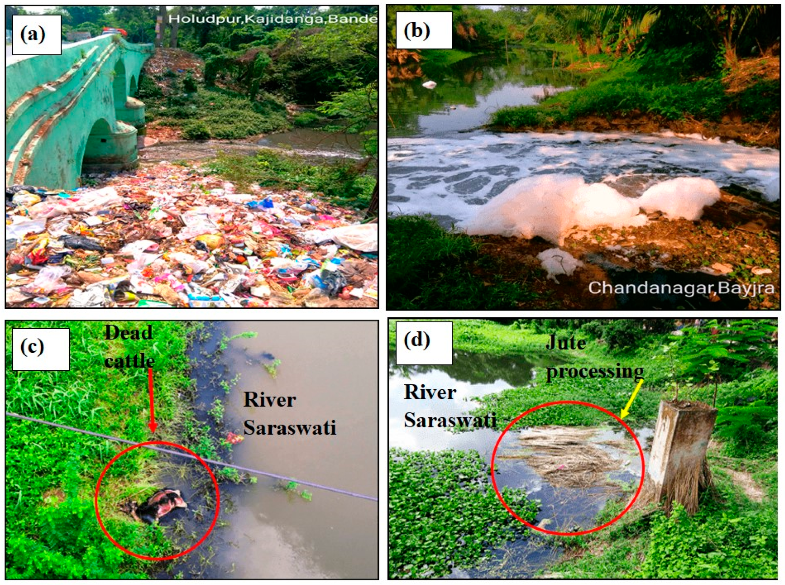
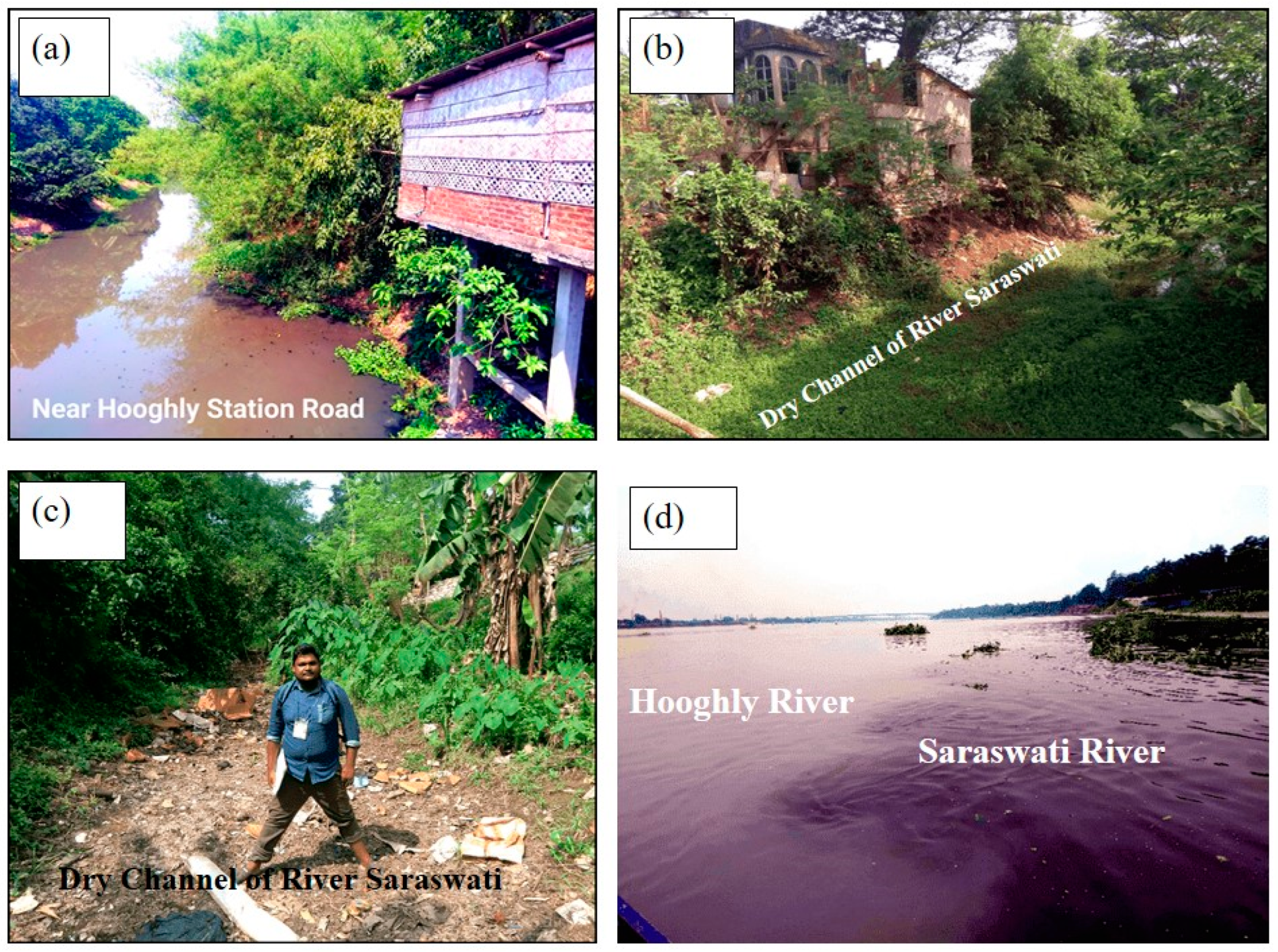
4.1. Anthropogenic and Environmental Factors Causing River Degradation

Anthropogenic and environmental factors have significantly contributed to the degradation of the historic Saraswati River in Bengal, a region known as the “land of rivers” [47]. Once a vibrant distributary of the Bhagirathi River, active until around the 16th century AD, the Saraswati has now dwindled into an insignificant stream, the “Saraswati Nala”, due to a combination of natural and human-induced interventions [48]. Over time, sections of the river have vanished from the surface, likely owing to natural causes, though these are beyond the scope of this study. Recent attempts to rejuvenate the river through initiatives like the Mahatma Gandhi National Rural Employment Guarantee Act (MGNREGA) Scheme reflect growing concern for its declining health. The river’s deterioration is primarily attributed to pollution from various point and non-point sources [49]. Urban solid wastes, including industrial and domestic refuse such as plastics, biomedical waste, rubber tires, thermocol, foam sheets, and broken glass, are frequently dumped along its banks. In areas like Saptagram, Bandel, Kestopur, and Chandannagar, polluted water from soap factories, spirit factories, and urban sewage mixes with river water. Dead animals, cremation ashes, and decomposing jute fibers further exacerbate contamination, promoting the growth of microorganisms, germs, and mosquitoes in stagnant waters (Figure 3). Rapid urbanization and infrastructural development since 1947 have also contributed to the river’s decline [50]. The construction of major transportation networks such as G.T. Road and the Eastern and South-Eastern Railways spurred urban encroachment along the riverbanks (Figure 4). Fertile alluvia attracted settlements and industrial activities like the use of brick kilns, transforming the Saraswati Basin into a hub of trade and commerce. This encroachment shifted land use patterns, further straining the river’s ecological balance. Channel modifications by the Damodar Valley Corporation (DVC) have also played a critical role. In efforts to renovate the region’s water channels, distributaries such as Ghia, Kana Damodar, and Kausiki were connected, diverting the Saraswati’s flow into alternative channels and causing heavy siltation in the main channel. This siltation, combined with the diversion of water from the Damodar River due to neo tectonic activity, has reduced Saraswati’s discharge, leaving it in a moribund state [51]. Continuous siltation and waterlogging further disrupt the river’s normal flow. Field observations indicate that during the rainy season, water from the DVC channels inundates the upper catchment of the Saraswati, creating wetlands and exacerbating waterlogging. This seasonal flooding deposits sediments on the banks, shrinking the channel and worsening the river’s condition. Eutrophication, driven by fertilizers, detergents, and bio-organisms, has compounded the problem, depleting oxygen levels and leading to excessive algae and plant growth in the river’s remnants. Collectively, these factors highlight the urgent need for comprehensive management and restoration efforts to revive the Saraswati River and mitigate its degradation.

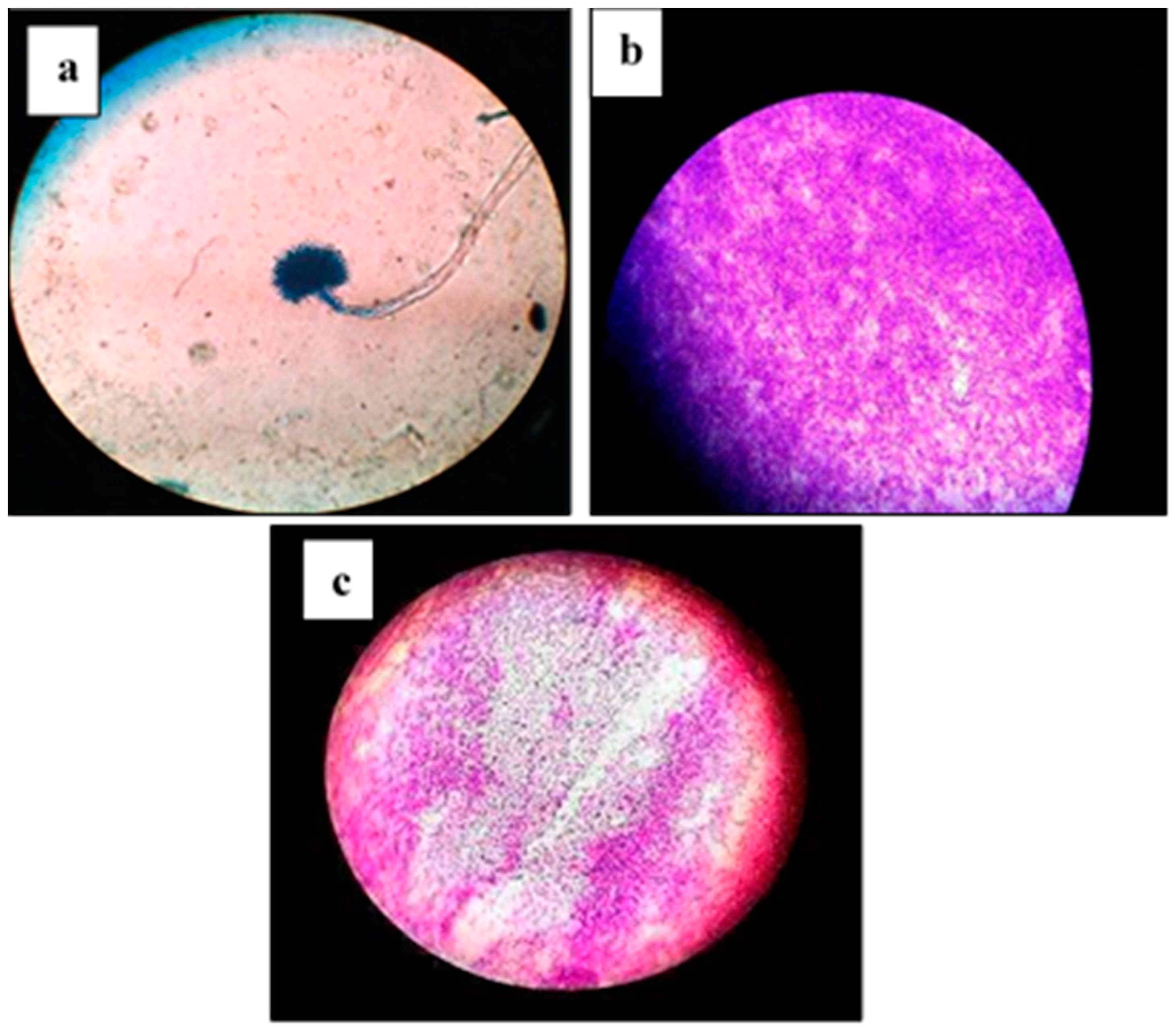
4.2. Microbial Properties Analysis of River Water

The presence of various types of bacteria in water significantly impacts its usability for diverse purposes, as noted in [52]. The Saraswati River is heavily contaminated with microbial pollutants, which raises serious concerns regarding its suitability for domestic, agricultural, and industrial applications. An analysis of the collected water samples revealed the presence of multiple microbial species, reflecting the extent of contamination. Among these, substantial bacterial growth was observed predominantly in the Bajra, Hooghly, Chinsurah, Jatilashwar Tala, and Chandannagore areas. These regions exhibited high concentrations of dominant microbial groups, including yeast, Escherichia coli (E. coli), Bacillus, Aspergillus, and Entamoeba (Figure 5). The presence of these microorganisms at various points along the river underscores the critical need for monitoring and managing microbial contamination to ensure the health and safety of the surrounding communities and ecosystems. This finding highlights the ongoing degradation of the river’s water quality, which is likely exacerbated by anthropogenic factors such as sewage discharge, industrial effluents, and agricultural runoff.

4.3. Electrolysis for Water Contamination Assessment

Table 3 presents the results of an electrolysis experiment conducted on eight water samples to evaluate their contamination levels. The table highlights changes in water color after the experiment and provides a detailed discussion on the pollutants identified in each sample. Observations include the presence of heavy metals, chemicals, fertilizers, pesticides, bacteria, viruses, acids, and organic matter, with sample temperatures during the experiment indicating varying levels of impurity. These findings reveal significant pollution across all samples, with notable differences in the types and intensity of contaminants (Table 3).

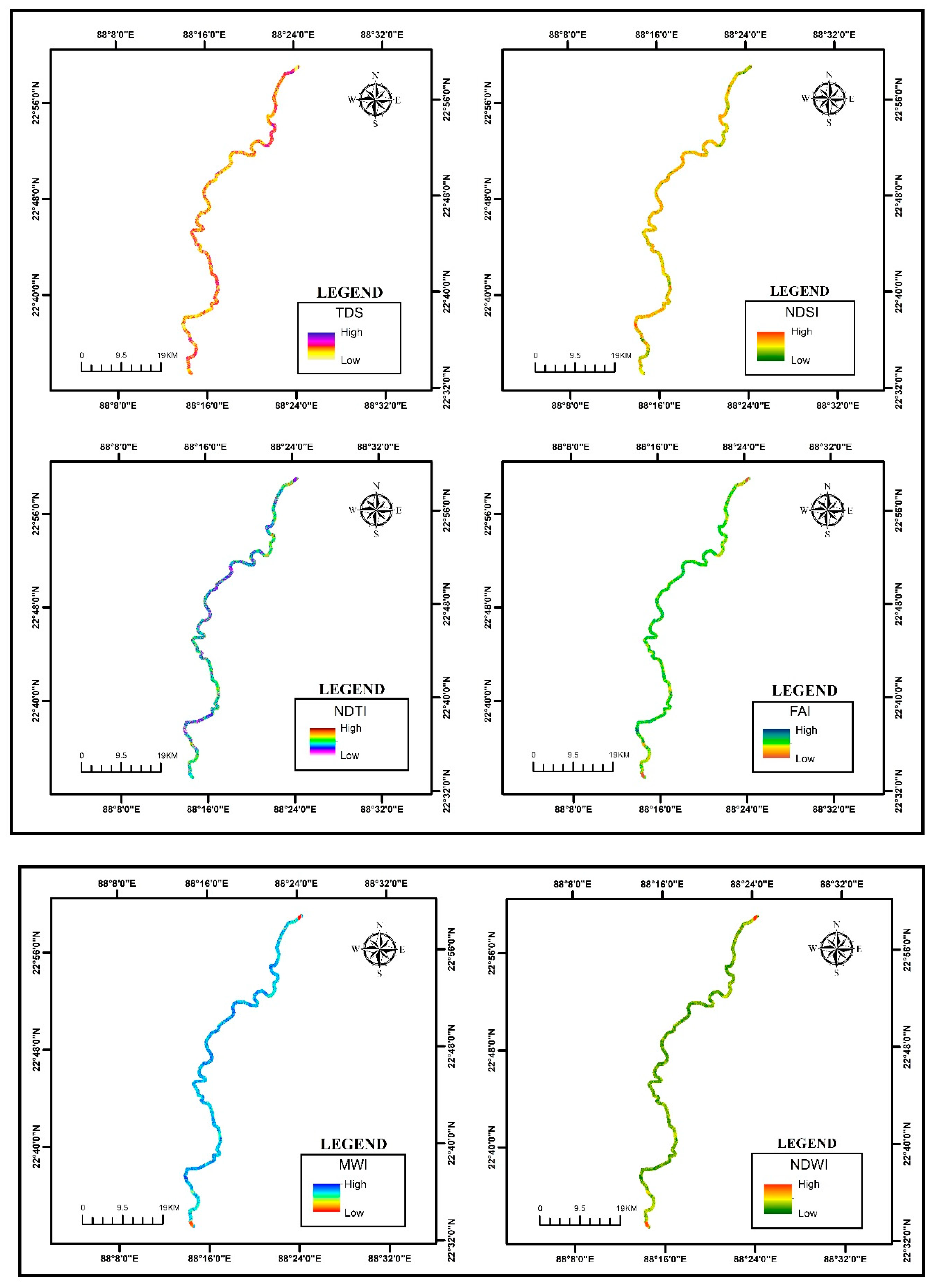
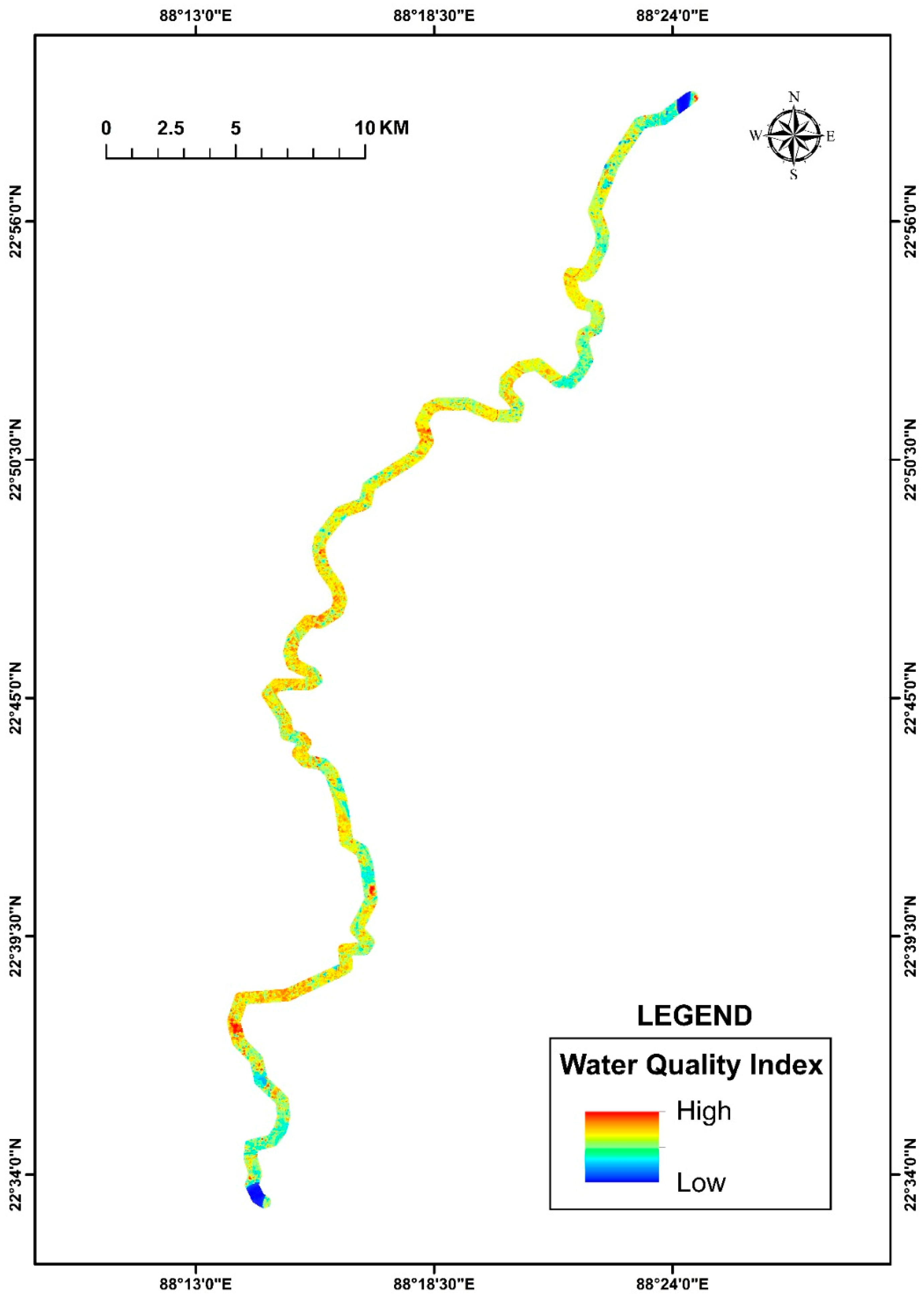
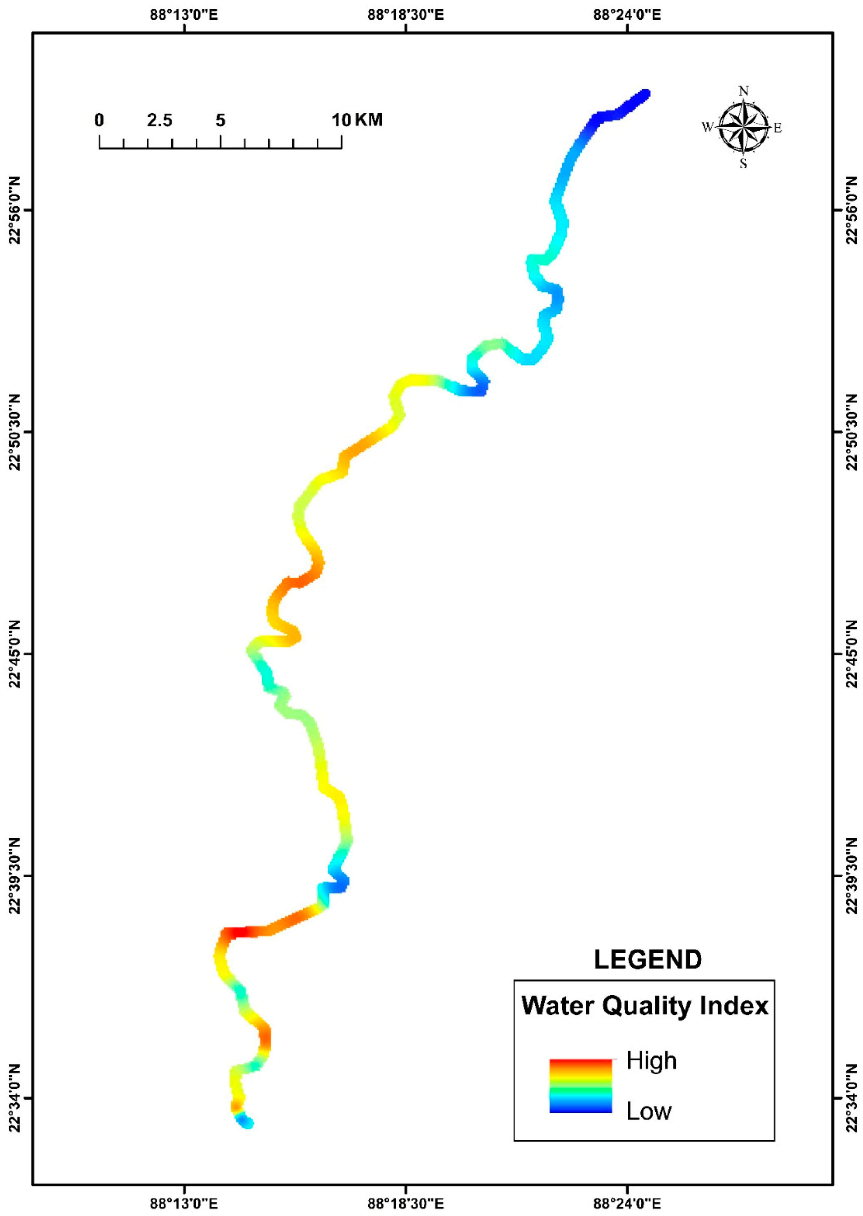
4.4. Water Quality Estimation Using Google Earth Engine (GEE) and Advanced Remote Sensing

TDS refers to the total concentration of dissolved substances in water, including minerals, salts, and organic compounds, and is measured in milligrams per liter (mg/L) or parts per million (ppm). This parameter is a key indicator of water quality and is particularly significant for assessing the Saraswati River. In urban areas such as Dakshin Hazipur, TDS levels are notably high due to urban sewage discharge, road salts, and runoff from developed areas. On the other hand, regions like Purbannapara, characterized by forested landscapes, exhibit lower TDS levels due to natural filtration and minimal anthropogenic impact. The NDSI serves as a valuable tool for detecting soil salinity, which is crucial for agricultural management and monitoring soil health. By analyzing light reflectance from the shortwave infrared (SWIR) and red wavelengths, the NDSI highlights areas of high salinity. For example, Hambirpur shows elevated NDSI values, primarily due to low soil moisture and exposed, vegetation-free soil. In contrast, Bhushnara has low NDSI values, attributed to its dense vegetation and higher soil moisture levels. Water turbidity, or cloudiness caused by suspended particles, is effectively measured using the NDTI. This index is pivotal for tracking pollution, studying aquatic ecosystems, and monitoring water quality. In Dakshin Hazipur, high NDTI values reflect the presence of suspended sediments, algae, and industrial runoff. Conversely, Hambirpara demonstrates lower NDTI values due to its dense vegetation, which minimizes sediment and particle loads in the water. The FAI identifies floating algae, such as harmful cyanobacterial blooms, which pose serious environmental and public health risks. Hambirpara registers high FAI values, indicating the prevalence of algal blooms fueled by turbid water conditions. Meanwhile, Jatrasudhi, located near the mouth of the Hooghly River, has lower FAI values due to the constant influx of fresh water, which dilutes nutrient concentrations and limits algal growth. Similarly, the NDCI estimates chlorophyll-a concentrations, a key marker of phytoplankton abundance and water quality. In Hambirpara, high NDCI values correspond to the elevated presence of floating algae, whereas in Jatrasudhi, low NDCI values reflect limited phytoplankton activity, consistent with its lower FAI levels. The MNDWI enhances the detection of water bodies in areas with significant vegetation or urban development. This index uses SWIR bands to effectively differentiate water from surrounding land features. Andul, with numerous lakes and water bodies, exhibits the highest MNDWI values. In contrast, Subhipur, with its mix of vegetation and urban structures, shows lower MNDWI values. The MWI, another advanced tool for water body detection, improves upon traditional indices by combining green and SWIR bands. This approach ensures better differentiation between water and surrounding features like vegetation and urban landscapes. Jatrasudhi records high MWI values due to its abundance of water bodies, while Kolupukur Kumarpara registers lower values due to the absence of significant water coverage. Lastly, using satellite imagery, the NDWI helps identify and track water bodies. This index is instrumental in monitoring flood events, water levels, and aquatic environments. Jatrasudhi, situated near the Hooghly River’s mouth, shows high NDWI values due to its proximity to abundant water. Conversely, Purbannapara has low NDWI values due to a limited water body presence and the dominance of urban areas (Figure 6).
The water quality of the Saraswati River shows significant spatial variation, influenced by a combination of natural, quasi-natural, and human factors. At Jatrasudhi, the WQI is relatively low, indicating better water quality, while at Purbannapara, the index rises dramatically to 202.544, signaling severe water quality deterioration. This stark contrast arises from various environmental and anthropogenic influences. Industrial discharges and agricultural runoff contribute heavily to pollution levels, introducing hazardous chemicals and nutrients into the water. Urbanization further exacerbates the issue by increasing waste generation and untreated sewage discharge into the river. Variations in water flow and sedimentation patterns also play a role in the spatial differences, as pollutants tend to accumulate in areas with reduced flow or increased sediment load. Seasonal factors, particularly the monsoon cycle, influence water quality by altering flow rates and washing additional contaminants into the river. Proximity to groundwater sources adds another layer of complexity, as interactions between surface and subsurface waters can alter the chemical composition of the river (Figure 7).

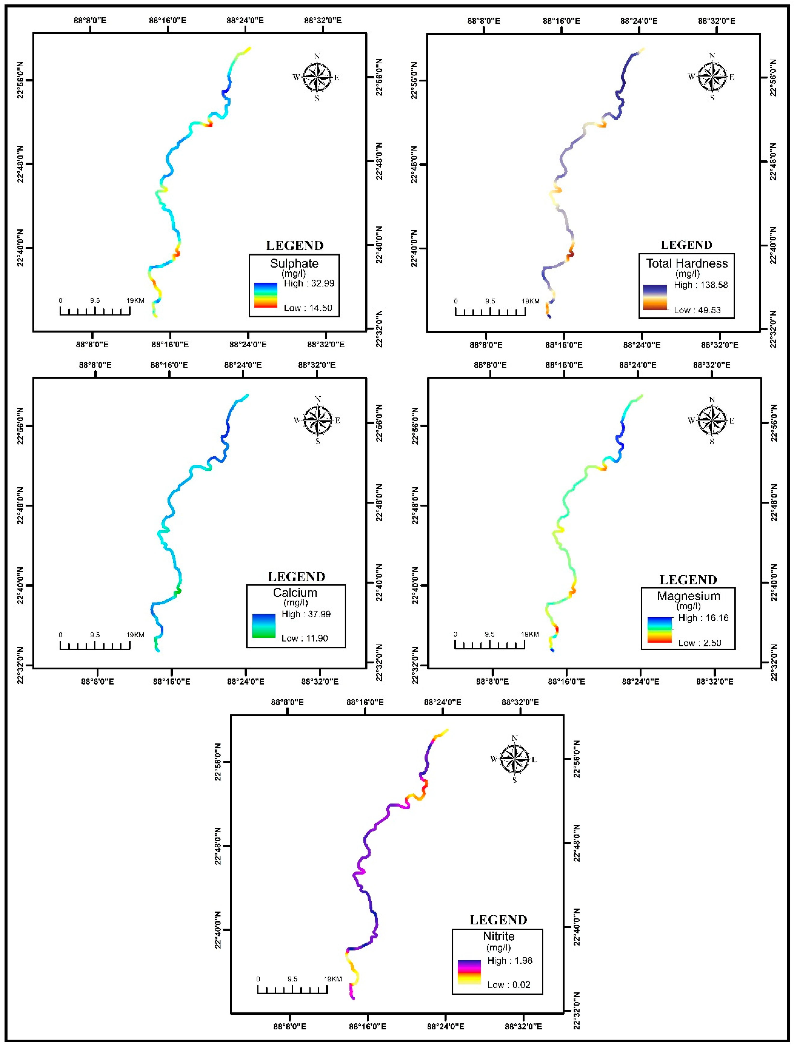
4.5. WQI Using Field Data and Arithmetic Weighted Index
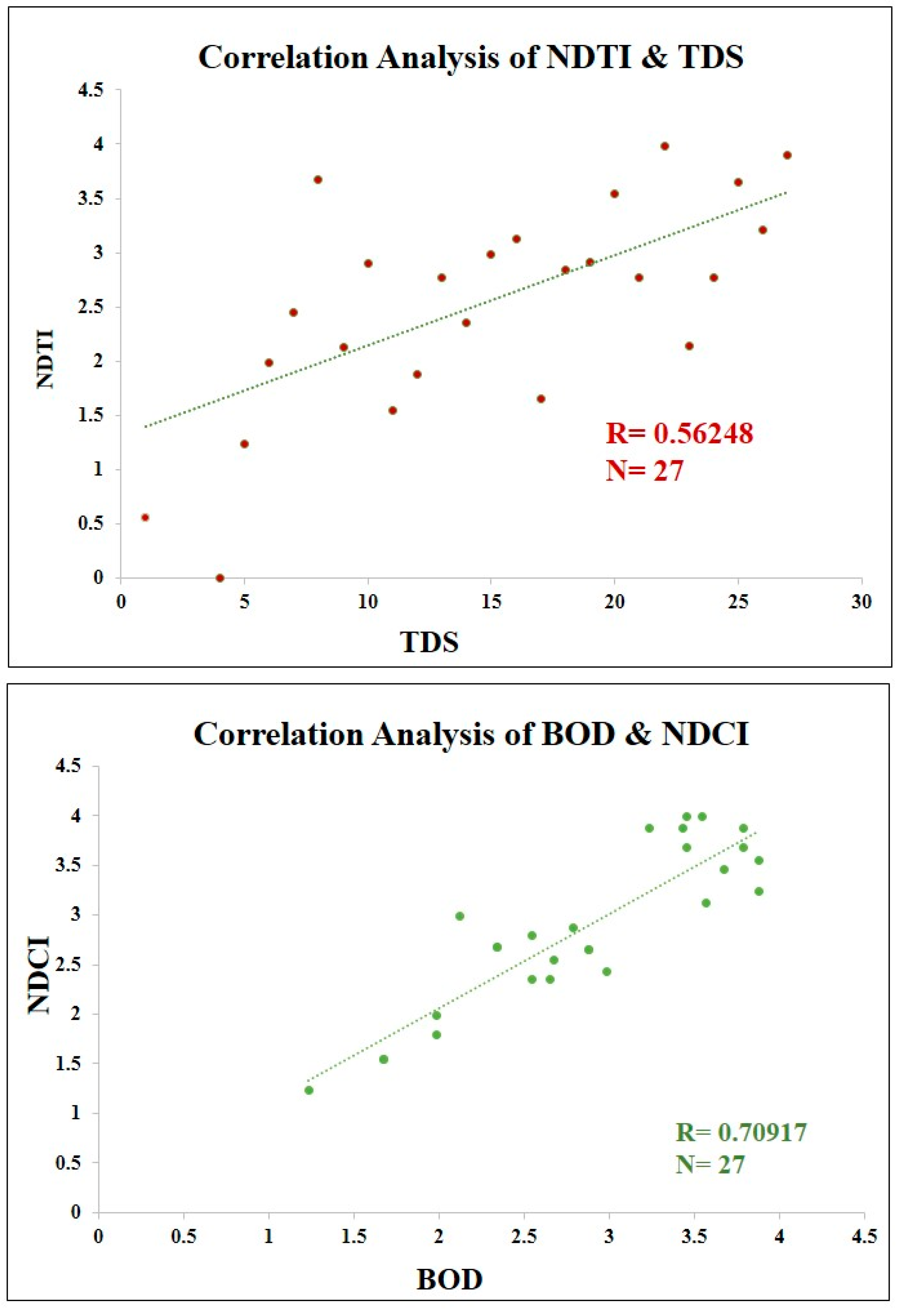
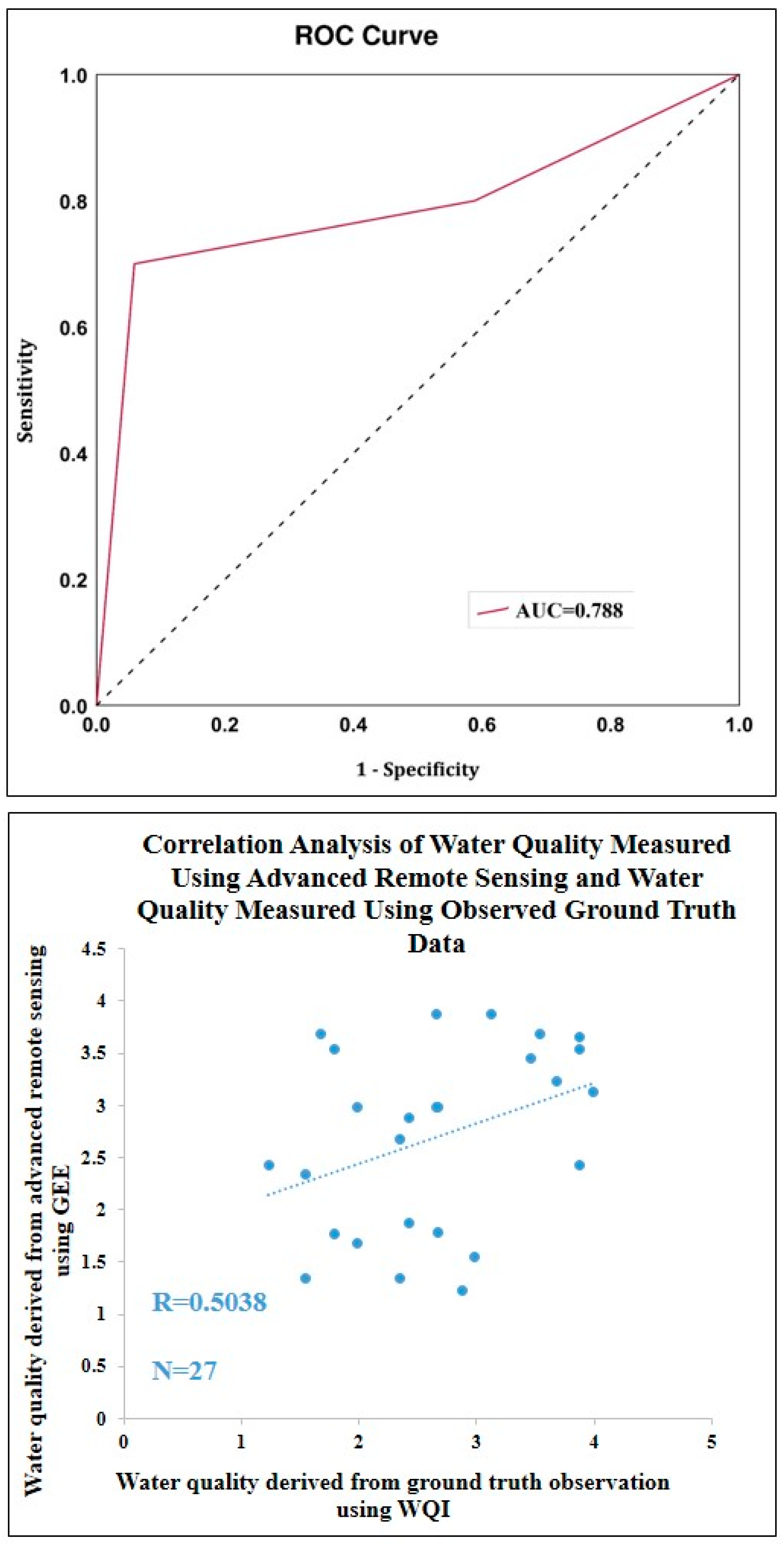
Water quality parameters, including pH, TDS, EC, DO, BOD, total coliform, sulfate, total hardness, calcium, magnesium, and nitrite levels, are vital indicators of aquatic ecosystem health influenced by various anthropogenic and natural factors. Twenty-seven sampling stations observed the data used for the WQI calculation. In this study, the WQI was computed using field data and an arithmetic weighted index. The mean individual quality parameters and the water quality index (WQI) are presented in Table 4. The pH, a measure of acidity or alkalinity ranging from 0 to 14, was highest in Binoypalli and Joychanditala at 8 and lowest in Purbannapara at 7.1, with elevated values linked to alkaline substances such as cleaning agents, industrial discharges, or agricultural runoff containing lime or fertilizers. TDS, representing the total concentration of dissolved solids in water, ranged from 680 mg/L in Karuripara to 188 mg/L in Jatrasudhi, with variations attributed to agricultural runoff, urban runoff, and industrial effluents or dilution by rainwater and advanced filtration processes. EC, which measures water’s ability to conduct an electrical current, was highest in Manushpara at 1313 µS/cm and lowest in Jatrasudhi at 376 µS/cm, influenced by saline water intrusion, road salt washoff, and agricultural runoff, while dilution by freshwater and reduced pollution lowered the EC. DO, crucial for aquatic life, ranged from 7.01 mg/L in Subhipur to 1.66 mg/L in Joychanditala, with higher values linked to aquatic plant photosynthesis and wind action and lower values caused by eutrophication and organic waste disposal. The BOD, reflecting the oxygen consumed to decompose organic matter, was highest in Joychanditala at 21 mg/L and lowest in Jatrasudhi and Sankhanagar at 3 mg/L, with variations due to organic pollution, industrial discharge, and wastewater treatment efficiency. The total coliforms, a bacterial indicator of water safety, ranged from 2450 MPN/100 mL in Manushpur to 600 MPN/100 mL in Kolupukur Kumarpara, influenced by fecal contamination and poor sanitation or effective water treatment. Sulfates ranged from 33 mg/L in South Naldanga to 14.49 mg/L in Sakrail, linked to industrial discharge and sulfate-based fertilizers or efficient purification processes. The total hardness, a measure of dissolved calcium and magnesium ions, was highest in Andul at 139.62 mg/L and lowest in Sakrail at 49.51 mg/L, affected by evaporation rates, industrial runoff, and agricultural activity or rainfall and water treatment. Calcium, contributing to hardness, ranged from 38 mg/L in Manushpur to 11.9 mg/L in Sakrail, with high levels due to agricultural runoff and industrial pollution, and magnesium ranged from 16 mg/L in Manushpara to 2.5 mg/L in Joychanditala, influenced by saltwater intrusion, industrial effluents, or minimal pollution. Nitrites, measured as nitrates, were highest in South Naldanga at 1.9 mg/L and lowest in Jotgiri at 0.02 mg/L, with elevated levels linked to improper wastewater treatment or animal waste contamination, while effective nitrification and proper ecosystem balance maintained lower concentrations (Figure 8).
The WQI results revealed even sharper disparities. For instance, Gobra Station Road exhibited a WQI of 358.918, highlighting critical pollution levels, while Jatrasudhi maintained a lower value of 86.427, reflecting relatively better conditions. These variations are further compounded by quasi-natural factors, such as human-induced modifications to riverbanks and flow patterns, which alter the natural dynamics of the river system. Local practices, including improper waste disposal and the indiscriminate release of untreated sewage, significantly contribute to the deterioration of water quality in specific areas. The interplay of these diverse factors underscores the urgent need for comprehensive water management strategies. Addressing industrial pollution, promoting sustainable agricultural practices, and improving urban wastewater treatment systems are essential steps to mitigate these challenges. Understanding the complex interactions between natural and human influences is crucial for preserving the ecological health of the Saraswati River and ensuring its long-term sustainability (Figure 9).
The degradation of the Bengal Saraswati River is a multi-faceted problem with both environmental and human causes. Human activities of urbanization, industrialization, and the development of infrastructure have transformed the natural flow of the river in a radical manner, while pollution, sedimentation, and ecological imbalance have further contributed to its degradation. A holistic management and restoration strategy involving scientific interventions, policy measures, and community participation is necessary to overcome the above challenges. Proper river management is crucial to prevent degradation, and stringent policies are required to regulate industrial effluents, sewage disposal, and riverbank encroachment. Environmental legislation enforcement and monitoring on a regular basis can prevent further pollution, while effective waste disposal systems, sewage treatment facilities, and eco-friendly agricultural practices can minimize pollution levels. Local community involvement through cleanliness drives, education programs, and awareness generation builds a sense of responsibility and ownership, further augmenting conservation efforts. Green infrastructure, buffer zones, and regulated land use along riverbanks within sustainable urban planning can restrain the impact of urbanization on the river system.
Restoring the Saraswati River requires a combination of engineering solutions, ecological interventions, and nature-based approaches. Desiltation and dredging can remove excess sediment deposits, improve river flow, and prevent stagnation. Replanting native vegetation along riverbanks helps control erosion, enhances water retention, and supports diverse aquatic and terrestrial ecosystems. Additionally, regulated water releases from the upper catchment and controlled inflows from the Damodar Valley Corporation (DVC) channels can restore the river’s natural hydrological cycle.
Bioremediation and phytoremediation, utilizing biological agents such as bacteria, algae, and aquatic plants, can help eliminate pollutants and improve water quality. Remote sensing technologies, including Google Earth Engine (GEE), can monitor water quality fluctuations, sedimentation rates, and land use changes, enabling data-driven decision-making for sustainable restoration efforts. Integrating traditional ecological knowledge with modern scientific expertise is essential for a holistic restoration plan. Indigenous water management practices, historical hydrological records, and cultural perspectives on river conservation provide valuable insights for sustainable strategies, while GIS mapping, hydrological modeling, and artificial intelligence-based monitoring ensure long-term success.
Sustained efforts and interdisciplinary collaboration are crucial for rejuvenating the Saraswati River. Institutionalizing policy frameworks, strengthening governance mechanisms, and fostering public–private partnerships for funding restoration activities are key to achieving long-term success. Advancing scientific research to enhance water quality and hydrological restoration techniques will further support these efforts. Additionally, promoting eco-tourism and sustainable livelihoods linked to river conservation can generate economic benefits while preserving the environment. A comprehensive strategy—combining policy measures, technological innovations, and community engagement—can effectively restore the Saraswati River, ensuring ecological balance and the sustainable management of water resources for future generations. This study faced several challenges due to the near-extinct state of the Saraswati River, making the tracing of its historical course a highly complex and labor-intensive task. The low water levels in many sections of the river further complicated sample collection, requiring careful planning and precise timing to ensure reliable data acquisition. Additionally, while specific indicators were used for assessing the river quality, certain important parameters could not be incorporated due to constraints on funding and time, as well as infrastructural limitations.

4.6. Validation

The accuracy of the NDCI and NDTI was validated by correlating them with relevant observed (ground-truth) water quality parameters using Pearson correlation. The analysis revealed a strong positive correlation between the NDCI and BOD (R = 0.7092), indicating that higher NDCI values are associated with increased BOD levels. Similarly, a moderate positive correlation was observed between the NDTI and TDS (R = 0.5625), suggesting that the NDTI can effectively reflect variations in organic pollution levels. These results highlight the potential of remote sensing-based indices for water quality assessment; however, further validation and calibration are necessary to enhance their accuracy and applicability across diverse water bodies (Figure 10).
The validation of water quality assessments using advanced remote sensing in GEE against actual measured water quality data (ground truth) was performed through ROC-AUC analysis and Pearson correlation. The ROC-AUC method assessed the classification accuracy of remotely sensed water quality indices, where higher AUC values indicate stronger predictive reliability. The obtained AUC value of 0.788 suggests a good level of classification performance, indicating that remote sensing-derived indices can effectively distinguish between different water quality conditions. This implies that the remote sensing approach has substantial potential for water quality monitoring, although some misclassification may still occur due to variations in environmental conditions and sensor limitations. Additionally, Pearson correlation (R = 0.5039, n = 27) demonstrated a moderate positive relationship between remote sensing-derived indices and in situ water quality parameters, indicating reasonable agreement (Figure 11).

5. Conclusions

The Saraswati River, an important historical waterway in Bengal, has faced severe ecological decline due to both natural and anthropogenic influences. This research aimed to assess the river’s current condition, identify the contributing factors to its degradation, and propose strategies for its restoration. The study utilized a blend of local knowledge, satellite data, and field observations to trace the river’s course, which is increasingly difficult due to its degraded state and limited accessibility. Technologies such as Garmin GPS, Google Earth Pro, Landsat imagery, and GEE facilitated the identification of the river’s path and supported the analysis of water quality using various remote sensing indices. Furthermore, water samples were collected at 27 locations along the river, where parameters like pH, TDS, EC, and microbial contamination were analyzed. Electrolysis and microbial identification methods were used to assess the extent of contamination, revealing high levels of pollutants such as heavy metals, agricultural chemicals, and bacteria.
The results showed significant water quality variations. For instance, locations like Jatrasudhi had a WQI of 86.427, indicating relatively better quality, while highly polluted areas such as Gobra Station Road had an alarmingly high WQI of 358.918. These variations were largely influenced by industrial discharges, agricultural runoff, and urban waste. High concentrations of harmful microorganisms such as E. coli, Bacillus, and Aspergillus were found in contaminated areas, especially in Bajra, Hooghly, and Chandannagar. These microorganisms correlate with the increased levels of pollution, demonstrating the severe impact of untreated sewage and industrial waste. Additionally, the presence of heavy metals and organic contaminants further contributed to the deteriorating health of the river, threatening aquatic life and posing health risks to local communities.
The findings highlight the urgent need for comprehensive restoration measures. To address the degradation, key interventions such as debris and silt removal, riverbank stabilization, and the construction of spoil banks should be implemented. The removal of pollutants, especially in the Tribeni outfall, will restore the natural flow and reduce stagnation. Strengthening the riverbanks using modern hydraulic structures will prevent erosion and flooding, while the reconstruction of damaged structures will improve the river’s capacity to manage water flow. Moreover, this study emphasizes the need for effective waste management and the treatment of industrial effluents and sewage to reduce pollutant levels. Addressing microbial contamination through wastewater treatment will also help improve the water quality and public health.
In conclusion, the Saraswati River’s degradation is a result of both historical changes and contemporary human activities. The combination of advanced remote sensing techniques and field-based sampling has provided an in-depth assessment of the river’s health. This study underscores the importance of sustainable management practices, including improved waste disposal, riverbank restoration, and infrastructure development, to rejuvenate the river. With the implementation of these recommendations, it is possible to mitigate further degradation and restore the ecological balance of the Saraswati River, allowing it to once again thrive as a key component of the region’s ecosystem.

Author Contributions

Conceptualization, A.D., M.B. and M.Z.; Methodology, S.K.; Software, S.D.; Validation, A.D., S.K. and S.D.; Formal analysis, R.R.; Investigation, M.B. and M.Z.; Resources, S.K.; Data curation, S.K.; Writing—original draft preparation, A.D.; Writing—review and editing, A.D., F.F.B.H., V.N.M. and M.Z.; Visualization, S.D.; Project administration, M.Z. All authors have read and agreed to the published version of the manuscript.

Funding

This research was funded by Princess Nourah bint Abdulrahman University Researchers Supporting Project number (PNURSP2025R675), Princess Nourah bint Abdulrahman University, Riyadh, Saudi Arabia.

Data Availability Statement

The datasets used and/or analyzed during the current study are available from the corresponding author on reasonable request.

Acknowledgments

The authors extend their appreciation to Princess Nourah bint Abdulrahman University Researchers Supporting Project number (PNURSP2025R675), Princess Nourah bint Abdulrahman University, Riyadh, Saudi Arabia. For information on the Saraswati River and Hooghly district, the authors are thankful to the Central Ground Water Board (CGWB), State Water Investigation Directorate (SWID), Central Water Commission (CWC), West Bengal Pollution Control Board (WBPCB), agro-irrigation authorities, Block Development Office of Hooghly, and local indigenous peoples. The authors also thank the anonymous reviewers for their insightful criticism and suggestions.

Conflicts of Interest

The authors declare no conflict of interest.

References

  1. Shil, S.; Singh, U.K.; Mehta, P. Water quality assessment of a tropical river using water quality index (WQI), multivariate statistical techniques and GIS. Appl. Water Sci. 2019, 9, 168. [Google Scholar] [CrossRef]
  2. Bera, A.; Das, S. Water resource management in semi-arid Purulia district of West Bengal, in the context of sustainable development goals. In Groundwater and Society; Springer: Cham, Switzerland, 2021; pp. 501–519. [Google Scholar] [CrossRef]
  3. Jarvie, H.P.; Whitton, B.A.; Neal, C. Nitrogen and phosphorus in east coast British rivers: Speciation, sources and biological significance. Sci. Total Environ. 1998, 210, 79–109. [Google Scholar] [CrossRef]
  4. Finnveden, G.; Hauschild, M.Z.; Ekvall, T.; Guinée, J.; Heijungs, R.; Hellweg, S.; Annette Koehler, A.; Pennington, D.; Suh, S. Recent developments in life cycle assessment. J. Environ. Manag. 2009, 91, 1–21. [Google Scholar] [CrossRef]
  5. Stoate, C.; Baldi, A.; Beja, P.; Boatman, N.D.; Herzon, I.; Van Doorn, A.; de Snoo, G.R.; Ramwell, C. Ecological impacts of early 21st century agricultural change in Europe—A review. J. Environ. Manag. 2009, 91, 22–46. [Google Scholar] [CrossRef]
  6. Khan, M.Y.A.; Gani, K.M.; Chakrapani, G.J. Assessment of surface water quality and its spatial variation. A case study of Ramganga River, Ganga Basin, India. Arab. J. Geosci. 2016, 9, 28. [Google Scholar] [CrossRef]
  7. Nasrabadi, T.; Ruegner, H.; Schwientek, M.; Bennett, J.; Fazel Valipour, S.; Grathwohl, P. Bulk metal concentrations versus total suspended solids in rivers: Time-invariant & catchment-specific relationships. PLoS ONE 2018, 13, e0191314. [Google Scholar] [CrossRef]
  8. Mahata, H.K.; Maiti, R. Evolution of Damodar Fan Delta in the Western Bengal Basin, West Bengal. J. Geol. Soc. India 2019, 93, 645–656. [Google Scholar] [CrossRef]
  9. Ghosh, S. The impact of the Damodar valley project on the environmental sustainability of the lower Damodar basin in West Bengal, Eastern India. OIDA Int. J. Sustain. Dev. 2014, 7, 47–54. [Google Scholar]
  10. Patra, D.; Bandyopadhyay, S. River and Environmental Movement. Indian Anthropol. 2019, 49, 57–73. [Google Scholar]
  11. Gregory, K.J. The human role in changing river channels. Geomorphology 2006, 79, 172–191. [Google Scholar] [CrossRef]
  12. Singh, A.; Vyas, V. A Review on remote sensing application in river ecosystem evaluation. Spat. Inf. Res. 2022, 30, 759–772. [Google Scholar] [CrossRef]
  13. Wang, X.; Yang, W. Water quality monitoring and evaluation using remote sensing techniques in China: A systematic review. Ecosyst. Health Sustain. 2019, 5, 47–56. [Google Scholar] [CrossRef]
  14. Dasi, A.; Vani, K.S.; Reddybathina, V.; Charpe, A.; Tadikonda, U.K. Estimation of Water Quality Parameters Using Water Indices and GEE. In Proceedings of the 2023 IEEE International Conference on Contemporary Computing and Communications (InC4), Bangalore, India, 21–22 April 2023; IEEE: New York, NY, USA, 2023; Volume 1, pp. 1–6. [Google Scholar] [CrossRef]
  15. Xiong, Y.; Xu, W.; Lu, N.; Huang, S.; Wu, C.; Wang, L.; Kou, W. Assessment of spatial–temporal changes of ecological environment quality based on RSEI and GEE: A case study in Erhai Lake Basin, Yunnan province, China. Ecol. Indic. 2021, 125, 107518. [Google Scholar] [CrossRef]
  16. Wang, C.; Jia, M.; Chen, N.; Wang, W. Long-term surface water dynamics analysis based on Landsat imagery and the Google Earth Engine platform: A case study in the middle Yangtze River Basin. Remote Sens. 2018, 10, 1635. [Google Scholar] [CrossRef]
  17. Subramani, T.; Someswari, P. Identification and Analysis of Pollution in Thirumani Muthar River Using Remote Sensing. Int. J. Eng. Res. Appl. 2014, 4, 198–207. [Google Scholar]
  18. Kaplan, G.; Yalcinkaya, F.; Altıok, E.; Pietrelli, A.; Nastro, R.A.; Lovecchio, N.; Tsipa, A. The role of remote sensing in the evolution of water pollution detection and monitoring: A comprehensive review. Phys. Chem. Earth Parts A B C 2024, 136, 103712. [Google Scholar] [CrossRef]
  19. Najafzadeh, M.; Basirian, S. Evaluation of river water quality index using remote sensing and artificial intelligence models. Remote Sens. 2023, 15, 2359. [Google Scholar] [CrossRef]
  20. Zhang, F.; Chan, N.W.; Liu, C.; Wang, X.; Shi, J.; Kung, H.T.; Cao, N. Water Quality Index (WQI) as a Potential Proxy for Remote Sensing Evaluation of Water Quality in Arid Areas. Water 2021, 13, 3250. [Google Scholar] [CrossRef]
  21. Hachoł, J.; Hämmerling, M.; Bondar-Nowakowska, E. Applying the Analytical Hierarchy Process (AHP) into the effects assessment of river training works. J. Water Land Dev. 2017, 35, 63–72. [Google Scholar] [CrossRef]
  22. Zhran, M.; Ghanem, K.; Tariq, A.; Alshehri, F.; Jin, S.; Das, J.; Mousa, A. Exploring a GIS-based analytic hierarchy process for spatial flood risk assessment in Egypt: A case study of the Damietta branch. Environ. Sci. Eur. 2024, 36, 184. [Google Scholar] [CrossRef]
  23. Dutta, A.; Banerjee, M.; Ray, R. Land capability assessment of Sali watershed for agricultural suitability using a multi-criteria-based decision-making approach. Environ. Monit. Assess. 2024, 196, 237. [Google Scholar] [CrossRef] [PubMed]
  24. Wei, W.; Guo, Z.; Xie, B.; Zhou, J.; Li, C. Spatiotemporal evolution of environment based on integrated remote sensing indexes in arid inland river basin in Northwest China. Environ. Sci. Pollut. Res. 2019, 26, 13062–13084. [Google Scholar] [CrossRef] [PubMed]
  25. Dutta, A.; Dutta, A.; Nandi, D.; Banerjee, M.; K Das, H.; Chandra, S. Physicochemical and Biological Properties of Land and Water Bodies Surrounding Major Dumpsites in Kolkata. Int. J. Civ. Environ. Agric. Eng. 2024, 6, 45–59. [Google Scholar] [CrossRef]
  26. Mondal, S.; Parveen, M.T.; Alam, A.; Rukhsana; Islam, N.; Calka, B.; Zhran, M. Future Site Suitability for Urban Waste Management in English Bazar and Old Malda Municipalities, West Bengal: A Geospatial and Machine Learning Approach. ISPRS Int. J. Geo-Inf. 2024, 13, 388. [Google Scholar] [CrossRef]
  27. Barman, J.; Ali, S.S.; Nongrem, T.; Biswas, B.; Rao, K.S.; Pramanik, M.; Zhran, M. Comparing the effectiveness of landslide susceptibility mapping by using the frequency ratio and hybrid MCDM models. Results Eng. 2024, 24, 103205. [Google Scholar] [CrossRef]
  28. Dutta, A.; Ray, R.; Banerjee, M. Multi-criteria-based decision making approach for soil erosion susceptibility modelling of Sali River Basin, Bankura, India. Environ. Dev. Sustain. 2024, 1–26. [Google Scholar] [CrossRef]
  29. Chakrabortty, R.; Kumar, A.; Mishuk, S.R.; Pramanik, M.; Avtar, R.; Manna, H.; Zhran, M. Assessment of urban environment quality using analytical hierarchical process and multi-dimensional decomposition analysis for Mumbai metropolitan region, India. Adv. Space Res. 2025, 75, 2792–2809. [Google Scholar] [CrossRef]
  30. Pramanik, S.; Biswas, J.K.; Kaviraj, A.; Saha, S. Assessment of the present state and future fate of River Saraswati, India: Water quality indices and forecast models as diagnostic and management tools. CLEAN–Soil Air Water 2023, 51, 2200321. [Google Scholar] [CrossRef]
  31. Kadave, P.T.; Bhor, M.B.; Bhor, A.B.; Bhosale, M.S. Physicochemical analysis of open well water Samples near Industrial Area of Niphad, Nashik District,(Maharashtra), India. J. Environ. Sci. Toxicol. Food Technol. 2012, 1, 01–04. [Google Scholar] [CrossRef]
  32. Dhar, I.; Biswas, S.; Mitra, A.; Pramanick, P.; Mitra, A. COVID-19 Lockdown phase: A boon for the River Ganga water quality along the city of Kolkata. NUJS J. Regul. Stud. 2020, 5, 53. [Google Scholar]
  33. Chakraborty, S.; Mitra, A.; Pramanick, P.; Zaman, S.; Mitra, A. Scanning the water quality of lower Gangetic delta during COVID-19 lockdown phase using Dissolved Oxygen (DO) as proxy. NUJS J. Regul. Stud. 2020, 69–74. [Google Scholar]
  34. Mukherjee, P.; Pramanick, P.; Zaman, S.; Mitra, A. Eco-restoration of River Ganga water quality during COVID-19 lockdown period using Total Coliform (TC) as proxy. NUJS J. Regul. Stud. Spec. Issue 2020, 75–82. [Google Scholar]
  35. Chowdhury, P.; Mukhopadhyay, B.P.; Nayak, S.; Bera, A. Hydro-chemical characterization of groundwater and evaluation of health risk assessment for fluoride contamination areas in the eastern blocks of Purulia district, India. Environ. Dev. Sustain. 2022, 24, 11320–11347. [Google Scholar] [CrossRef]
  36. Swami, P.K.; Tyagi, A. Describing water quality with aggregate index. J. Environ. Eng. 2000, 126, 451–455. [Google Scholar]
  37. Dwivedi, S.L.; Pathak, V. A preliminary assignment of water quality index to Mandakini River, Chitrakoot. Indian J. Environ. Prot. 2007, 27, 1036–1038. [Google Scholar]
  38. Mukherjee, D.; Dora, S.L.; Tiwary, R.K. Evaluation of water quality index for drinking purposes in the case of Damodar River, Jharkhand and West Bengal Region, India. J. Bioremediation Biodegrad. 2012, 3, 161. [Google Scholar] [CrossRef]
  39. Selvam, S.; Manimaran, G.; Sivasubramanian, P.; Balasubramanian, N.; Seshunarayana, T. GIS-based evaluation of water quality index of groundwater resources around Tuticorin coastal city, South India. Environ. Earth Sci. 2014, 71, 2847–2867. [Google Scholar] [CrossRef]
  40. Kanakiya, R.S.; Singh, S.K.; Sharma, J.N. Determining the water quality index of an urban water body Dal Lake, Kashmir, India. IOSR J. Environ. Sci. Toxicol. Food Technol. 2014, 8, 64–71. [Google Scholar]
  41. Hou, W.; Sun, S.; Wang, M.; Li, X.; Zhang, N.; Xin, X.; Jia, R. Assessing water quality of five typical reservoirs in lower reaches of Yellow River, China: Using a water quality index method. Ecol. Indic. 2016, 61, 309–316. [Google Scholar] [CrossRef]
  42. Rana, R.; Ganguly, R.; Gupta, A.K. Indexing method for assessment of pollution potential of leachate from non-engineered landfill sites and its effect on ground water quality. Environ. Monit. Assess. 2018, 190, 46. [Google Scholar] [CrossRef]
  43. Chakraborty, B.; Roy, S.; Bera, A.; Adhikary, P.P.; Bera, B.; Sengupta, D.; Bhunia, G.S.; Shit, P.K. Cleaning the river Damodar (India): Impact of COVID-19 lockdown on water quality and future rejuvenation strategies. Environ. Dev. Sustain. 2021, 23, 11975–11989. [Google Scholar] [CrossRef] [PubMed]
  44. Brown, R.M.; McClelland, N.I.; Deininger, R.A.; Tozer, R.G. A Water Quality Index: Do We Dare? Water Sew. Work. 1970, 117, 339–343. [Google Scholar]
  45. Madhloom, H.M.; Al-Ansari, N.; Laue, J.; Chabuk, A. Modeling spatial distribution of some contamination within the lower reaches of Diyala River using IDW interpolation. Sustainability 2017, 10, 22. [Google Scholar] [CrossRef]
  46. Kumar, S.; Sangeetha, B. Assessment of ground water quality in Madurai city by using geospatial techniques. Groundw. Sustain. Dev. 2020, 10, 100297. [Google Scholar] [CrossRef]
  47. Rudra, K. Rivers of the Ganga-Brahmaputra-Meghna Delta: A Fluvial Account of Bengal; Springer: Berlin/Heidelberg, Germany, 2018. [Google Scholar] [CrossRef]
  48. Panigrahi, A.K.; Pattnaik, S. Water pollution effects of river Saraswati and Kunti on livelihood: A case study of fishermen communities in Tribeni and Kuntighat, Hooghly, West Bengal. J. Fish. 2020, 8, 928–934. [Google Scholar] [CrossRef]
  49. Mandal, B. Decay of Saraswati River with special emphasis on its environmental issues Hooghly & Howrah district, West Bengal. Open Access Int. J. Sci. Eng. 2017, 2, 13–22. [Google Scholar]
  50. Chakraborty, B.; Roy, S.; Bera, A.; Adhikary, P.P.; Bera, B.; Sengupta, D.; Bhunia, G.S.; Shit, P.K. Eco-restoration of river water quality during COVID-19 lockdown in the industrial belt of eastern India. Environ. Sci. Pollut. Res. 2021, 28, 25514–25528. [Google Scholar] [CrossRef]
  51. Chakraborty, A.; Bera, A.; Mukherjee, A.; Basak, P.; Khan, I.; Mondal, A.; Roy, A.; Bhattacharyya, A.; Sen Gupta, S.; Roy, D.; et al. Changing bacterial profile of Sundarbans, the world heritage mangrove: Impact of anthropogenic interventions. World J. Microbiol. Biotechnol. 2015, 31, 593–610. [Google Scholar] [CrossRef]
  52. Woutersen, M.; Belkin, S.; Brouwer, B.; Van Wezel, A.P.; Heringa, M.B. Are luminescent bacteria suitable for online detection and monitoring of toxic compounds in drinking water and its sources? Anal. Bioanal. Chem. 2011, 400, 915–929. [Google Scholar] [CrossRef]
Figure 1. Location of the study area.
Water 17 00965 g001
Figure 2. Methodological flow chart of the study.
Water 17 00965 g002
Figure 3. Various sources of pollution: (a) open dumping on the riverside near Bandel; (b) urban sewage water combining with river water at Chandannagar; (c) dead cattle are thrown into the river near Debanandapur, Hooghly; (d) jute stirs in the river water near Debanandapur, Hooghly.
Water 17 00965 g003
Figure 4. Present scenario: (a,b) anthropogenic interception (house on river channel near Bandel and Nasibpur, Hooghly); (c) dry river channel; (d) confluence of River Saraswati and River Hooghly.
Water 17 00965 g004
Figure 5. Microscopic views of (a) Aspergillus, (b) E. coli, and (c) Bacillus.
Water 17 00965 g005
Figure 6. Quality mapping of individual parameters in the present scenario using Google Earth Engine (GEE): Total Dissolved Solids (TDS), the Normalized Difference Salinity Index (NDSI), the Normalized Difference Turbidity Index (NDTI), the Floating Algae Index (FAI), the Normalized Difference Chlorophyll Index (NDCI), the Modified Normalized Difference Water Index (MNDWI), the Modified Water Index (MWI), and the Normalized Difference Water Index (NDWI).
Water 17 00965 g006
Figure 7. Overall water quality mapping using Google Earth Engine (GEE) and advanced remote sensing.
Water 17 00965 g007
Figure 8. Quality mapping of individual parameters collected in the field: pH, TDS, EC, DO, BOD, total coliforms, sulfates, total hardness, calcium, magnesium, and nitrites.
Water 17 00965 g008aWater 17 00965 g008b
Figure 9. Water quality index using field-tested data and arithmetic weighted index method.
Water 17 00965 g009
Figure 10. Correlation analysis of NDTI with TDS and NDCI with BOD levels.
Water 17 00965 g010
Figure 11. Receiver operating characteristic (ROC) curve and correlation analysis for validation.
Water 17 00965 g011
Table 1. AHP weight calculations and comparison matrix.
Total Dissolved Solids (TDS)Normalized Difference Salinity Index (NDSI)Normalized Difference Turbidity Index (NDTI)Floating Algae Index (FAI)Normalized Difference Chlorophyll Index (NDCI)Modified Normalized Difference Water Index (MNDWI)Modified Water Index (MWI)Normalized Difference Water Index (NDWI)
11222345
11122346
0.51112456
0.50.5111235
0.50.50.511124
0.3330.3330.250.51112
0.250.250.20.3330.5113
0.20.1660.1660.20.250.50.3331
AHP weights0.2230.2040.1890.1310.1010.0650.0540.029
Consistency Ratio (CR): 0.020
Table 2. Allowable limits of water quality parameters according to the Bureau of Indian Standards (BIS).
As per the Bureau of Indian Standards (BIS) Class ‘C’ (Drinking Water Source After Conventional Treatment)
Value
pH8.5
DO (mg/mL4
BOD (mg/mL) (5 days, 20 °C)3
Total Coliform Organisms (MPN/100 mL)5000
TDS (mg/L)1500
Sulfates (mg/L)400
Nitrates (as NO3) (mg/L)50
Total Hardness (mg/L) 200
Calcium (mg/L)75
Magnesium (mg/L)30
EC (µS/cm)500
Table 3. Electrolysis experiment results.
Sample no.Water Color after the ExperimentDiscussion
1Greenish yellowFrom this experiment, it is clear that this sample was highly polluted with heavy metals (arsenic, mercury, lead, copper, and sodium), acids, and organic matter, but the level of pollution was lower than that in other samples. During the experiment, the sample temperature reached 42 °C, which also indicated that the water was contaminated.
2BlueishThe sample was highly polluted with chemicals, fertilizers, pesticides, bacteria, and viruses. During the experiment, the sample temperature reached 52 °C, indicating sample impurities.
3Greenish blueThe sample was highly polluted with chemicals, fertilizers, pesticides, heavy metals (arsenic, mercury, lead, copper, and sodium), bacteria, and viruses. During the experiment, the sample temperature reached 60 °C, indicating sample impurities.
4Whiteish greenThe sample was highly polluted with heavy metals (arsenic, mercury, lead, copper, sodium, zinc, and mercury) and with bacteria and viruses that are highly affected by inorganic substances. During the experiment, the sample temperature reached 75 °C, indicating that the sample was highly impure in nature.
5YellowishThe sample was highly contaminated by acids, fluoride, and other organic matter. During the experiment, the sample temperature reached 45 °C, which also indicated that the water was impure.
6Blueish yellowThe sample was highly polluted with chemicals, fertilizers, pesticides, bacteria, and viruses; fluoride and acids were also present. During the experiment, the sample temperature reached 41 °C, which also indicated that the water was contaminated.
7Blueish yellowThe sample was highly polluted with chemicals, fertilizers, pesticides, bacteria, and viruses; fluoride and acids were also present. During the experiment, the sample temperature reached 42 °C, which also indicated that the water was impure.
8Greenish blueThe sample was highly polluted with chemicals, fertilizers, pesticides, heavy metals (arsenic, mercury, lead, copper, and sodium), bacteria, and viruses. During the experiment, the sample temperature reached 50 °C, indicating sample impurities.
Table 4. Mean individual quality parameters and WQI.
Sample No.pHTDS (mg/mL)EC (µS/cm)DO (mg/mL)BOD (mg/mL)Total Coliforms (MPN/100 mL)Sulfates (mg/L)Total Hardness (mg/L)Calcium (mg/L)Magnesium (mg/L)Nitrites (mg/L)WQI
17.81883763.4399020.890.92590.3886.42751
27.83346683.93105022.6512328100.6890.93435
37.638677147200025129.732111.9148.8886
47.86561313.004.98245030.2138.638161.8171.9309
57.84258084.8102309331293715.31.9199.2705
684508804.5620002912831160.9140.0327
77.82024564.2817002712133140.7165.3216
87.63506384.31260028.511036110.6222.5919
97.63968216.0814.00124325.9097.1125.909.091.73265.0762
107.85129376.9416.25141829.54110.7829.5410.371.60304.8411
117.74859106.7412.00137728.69107.5828.6910.071.80242.2821
127.66229477.0118.00143429.88112.0329.8810.481.70330.1181
137.62506755.0017.00102221.2979.8421.297.471.42298.7371
147.33667915.869.00119724.9493.5224.948.751.67191.2476
157.54568816.5311.00133427.79104.2227.799.751.86225.8285
167.75869116.7514.00137928.73107.7328.7310.081.92270.9204
177.24929176.7918.00138828.92108.4428.9210.151.93327.5279
187.8520945720.00143029.79111.7229.7910.451.99358.9186
197.44328493.131192016.64108.9127.289.270.71198.2169
207.54408573.11692022.65118.8233.738.110.02269.5482
2186189351.662192020.4189.1235.722.50.3329.4884
227.36808971.8812240030.2118.8127.7811.580.21202.6836
237.16049213.914.75240021.6369.3115.886.951.5256.804
247.26548714.5918240025.169.3115.886.951.3308.909
257.65409574.296240021.22138.6227.7816.221.6137.7026
267.35389553.95160014.4969.3119.844.641.5117.6808
277.45589752.93692015.5149.5111.94.641.7124.1218
Parameters:pHTDS (mg/mL) EC (µS/cm) DO (mg/mL)BOD (mg/mL)Total Coliforms (MPN/100 mL) Sulfates (mg/L)Total Hardness (mg/L) Calcium (mg/L)Magnesium (mg/L) Nitrites (mg/L) WQI
Max8.00 68.00 1313.00 7.01 21.00 2450.00 33.00 138.62 38.00 16.22 1.99358.92
Min7.10188.00376.001.663.00600.0014.4949.5111.902.500.0286.43
Mean7.59471.85846.744.7411.701525.9625.17105.0027.829.991.31221.71
Disclaimer/Publisher’s Note: The statements, opinions and data contained in all publications are solely those of the individual author(s) and contributor(s) and not of MDPI and/or the editor(s). MDPI and/or the editor(s) disclaim responsibility for any injury to people or property resulting from any ideas, methods, instructions or products referred to in the content.

