

Benefits of an Airborne Electromagnetic Survey of Former Opencast Lignite Mining Areas in Lusatia, Germany


Abstract
1. Introduction
2. Materials and Methods
2.1. Geology and Hydrogeology of the Survey Area
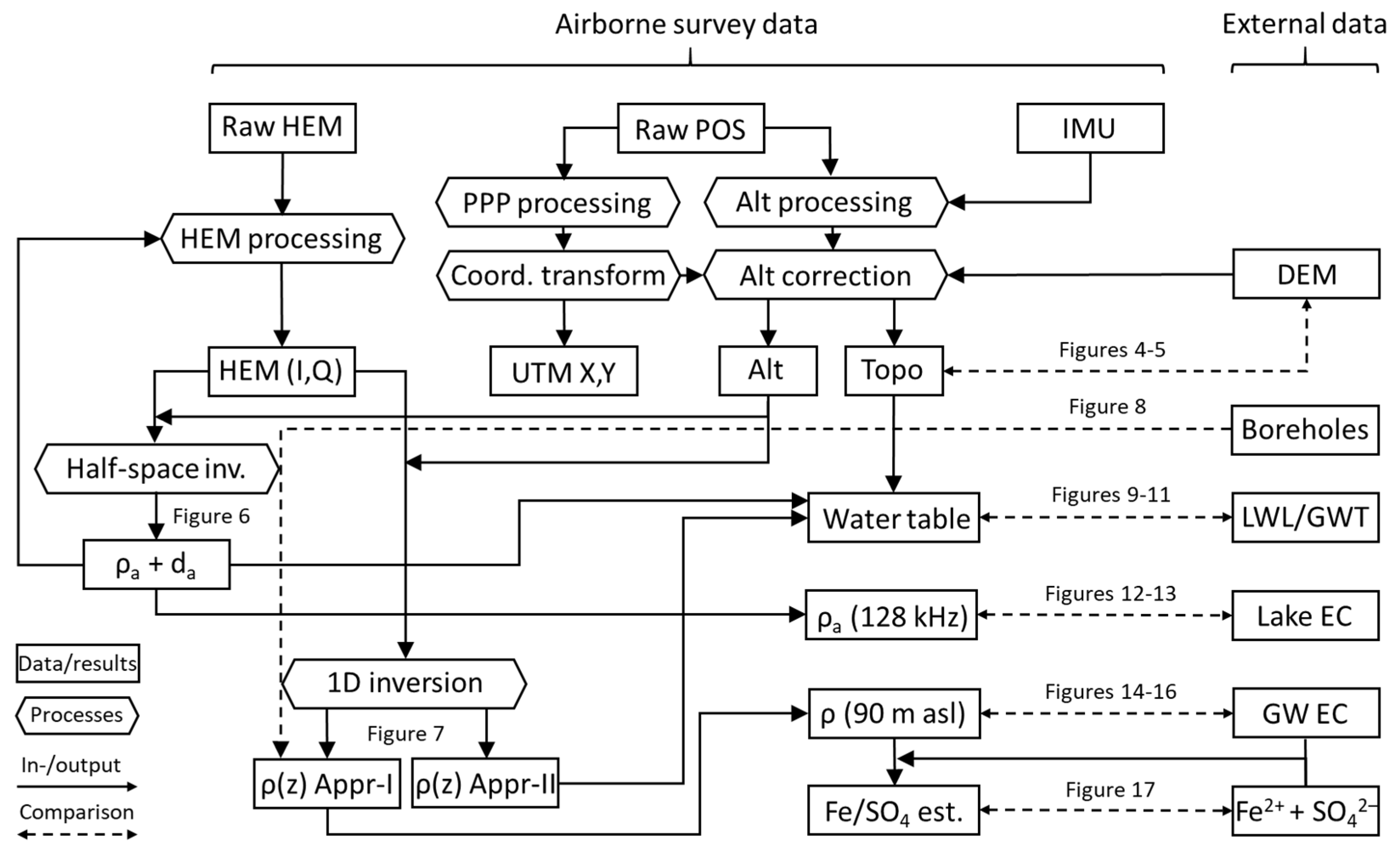
2.2. Airborne Geophysical Survey
2.3. Airborne Data
2.3.1. Position Data Processing
2.3.2. HEM Data Processing
2.3.3. HEM Data Inversion
2.4. External Material
2.5. Interpretation of HEM Data
2.5.1. Water Table Estimation
2.5.2. Water Quality Estimation
3. Results
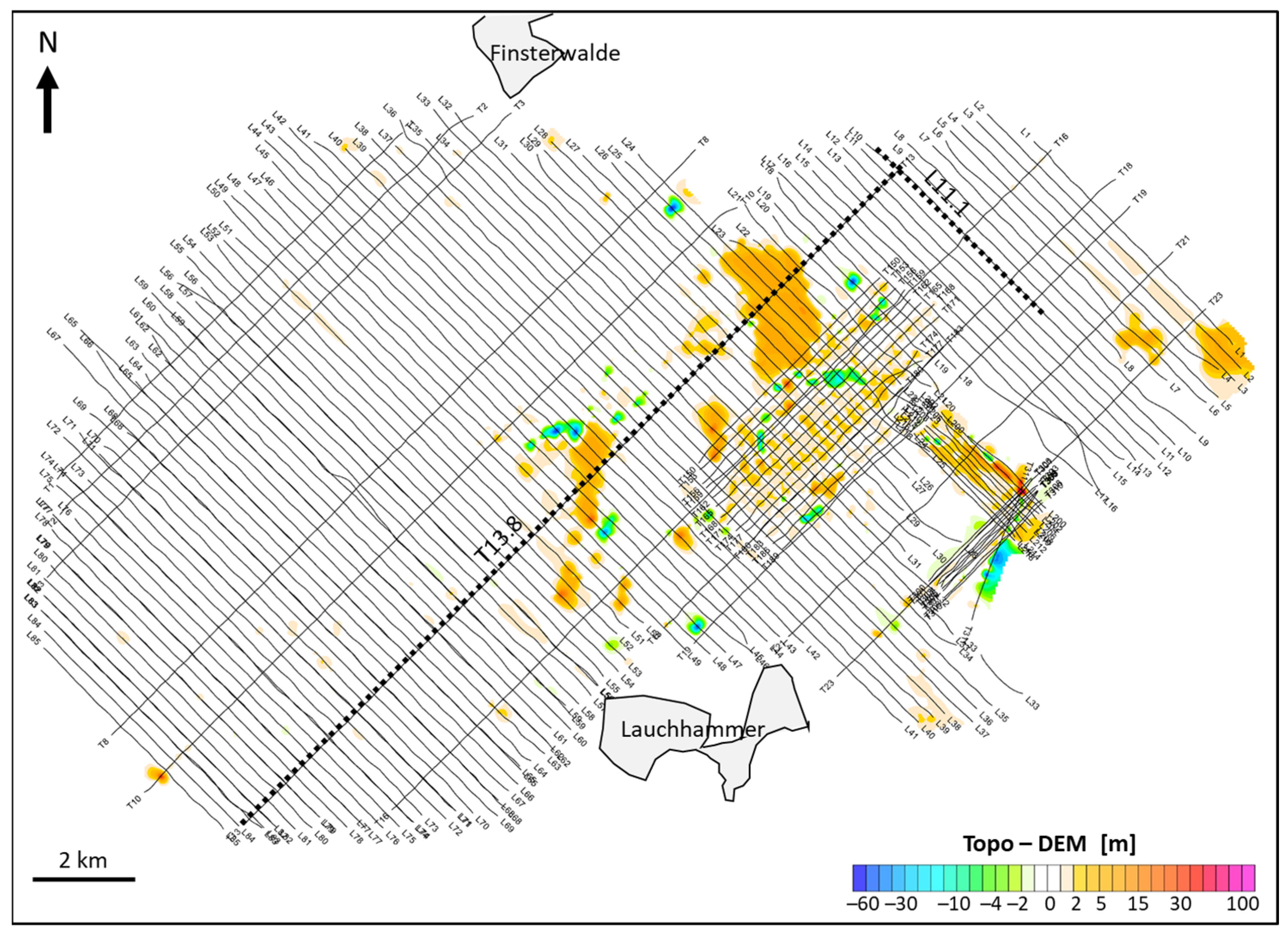
3.1. Terrain Elevation
3.2. General HEM Results
3.3. Special HEM Results
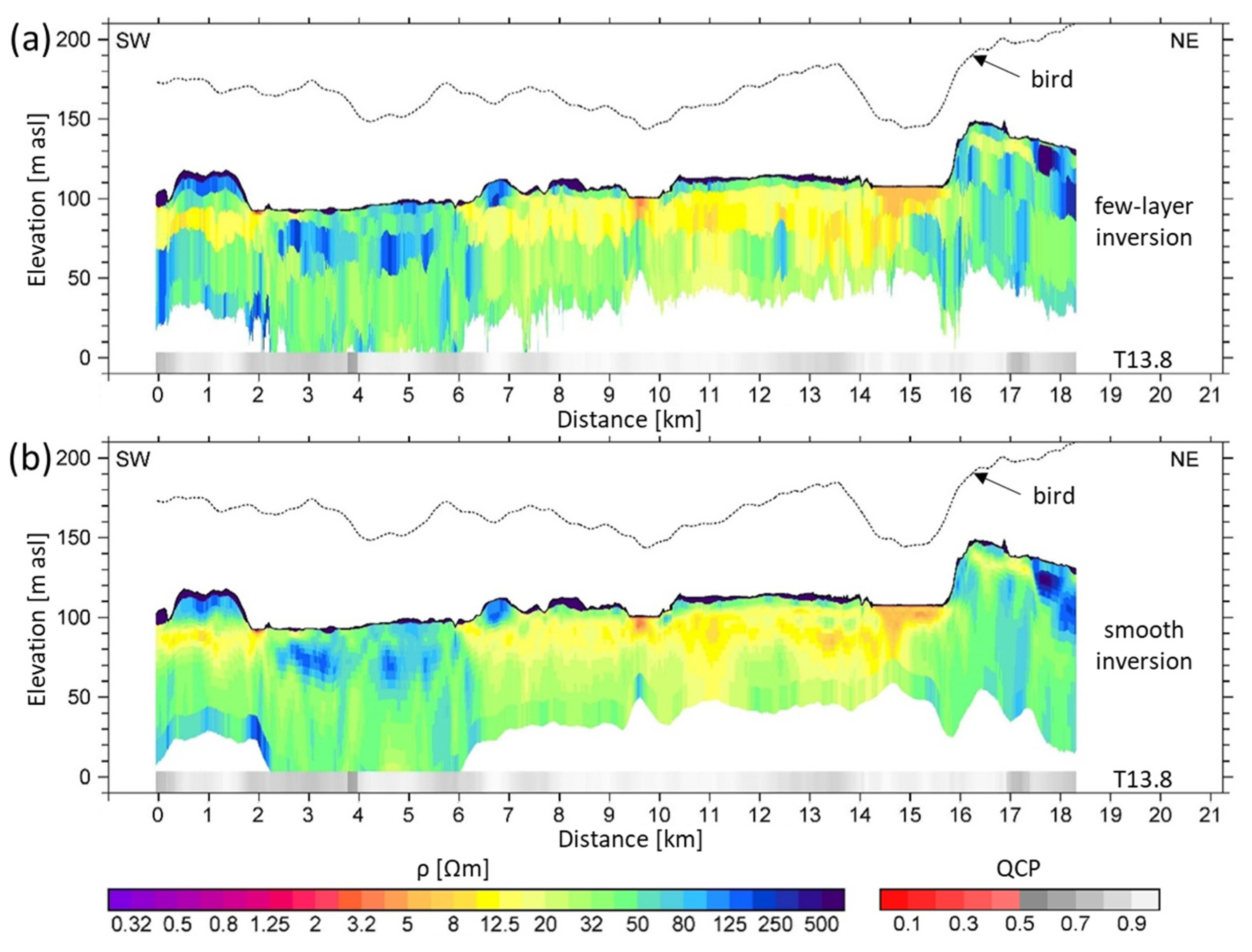
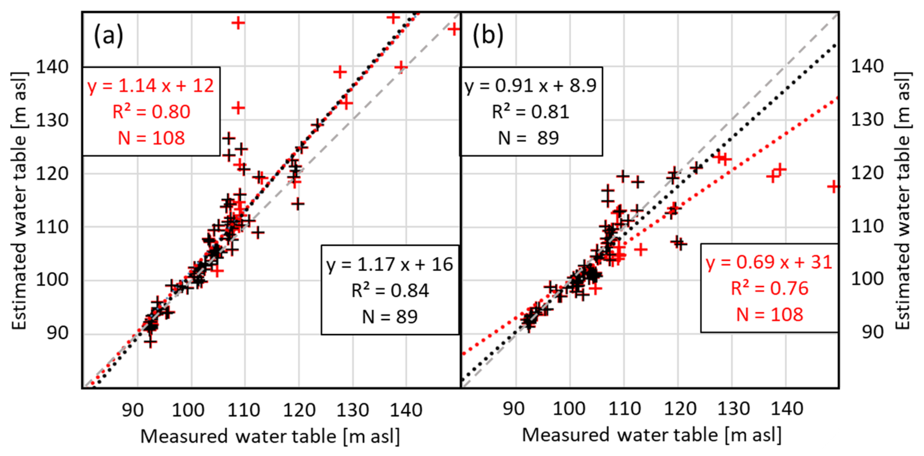
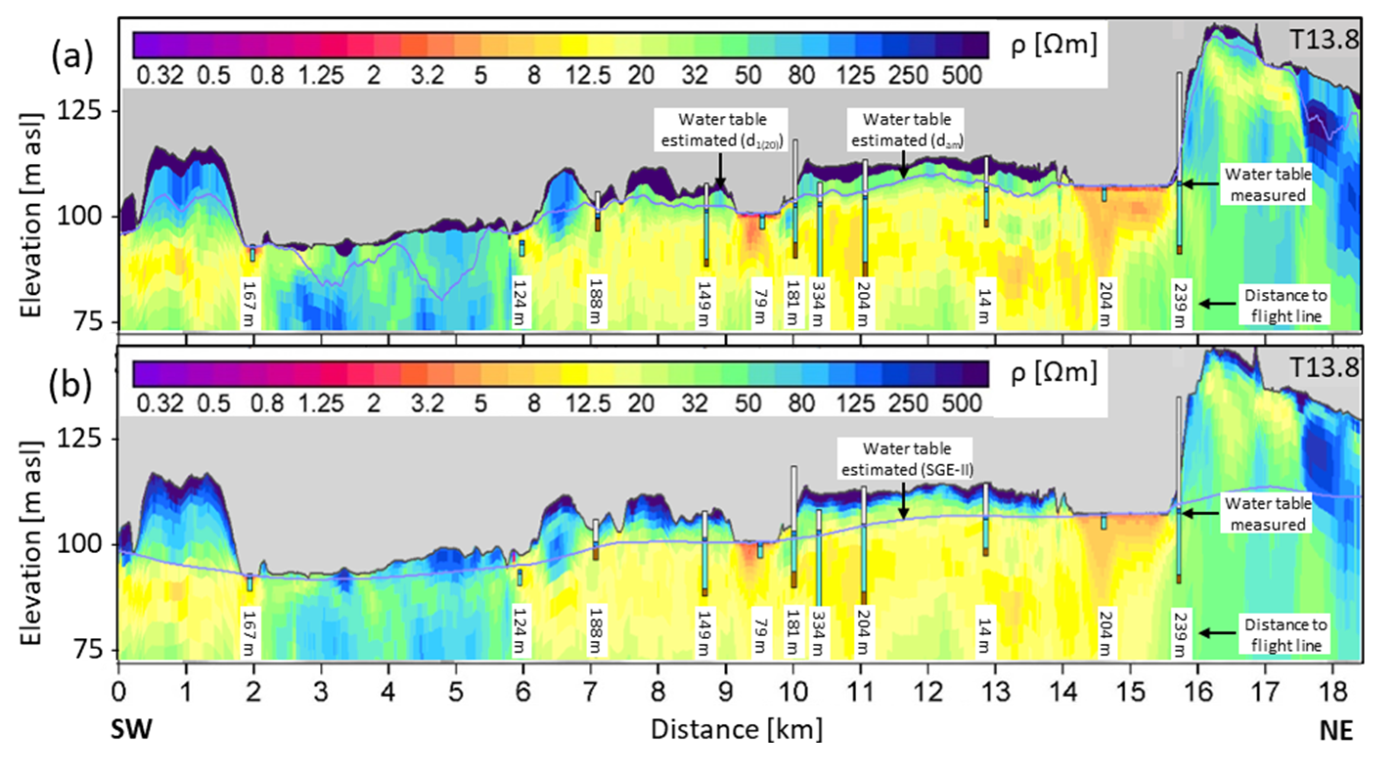
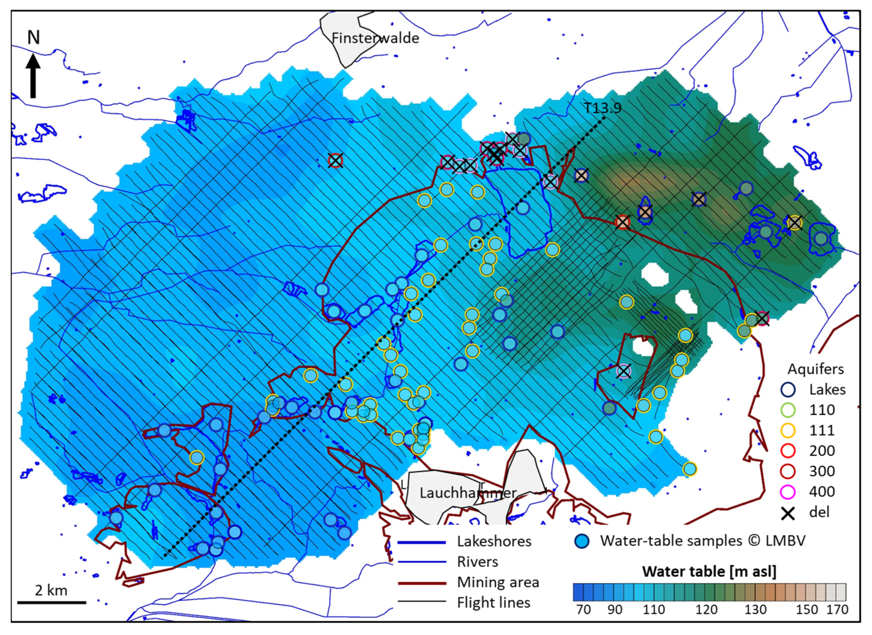
3.3.1. Water Table
3.3.2. Lake Water EC
3.3.3. Groundwater EC
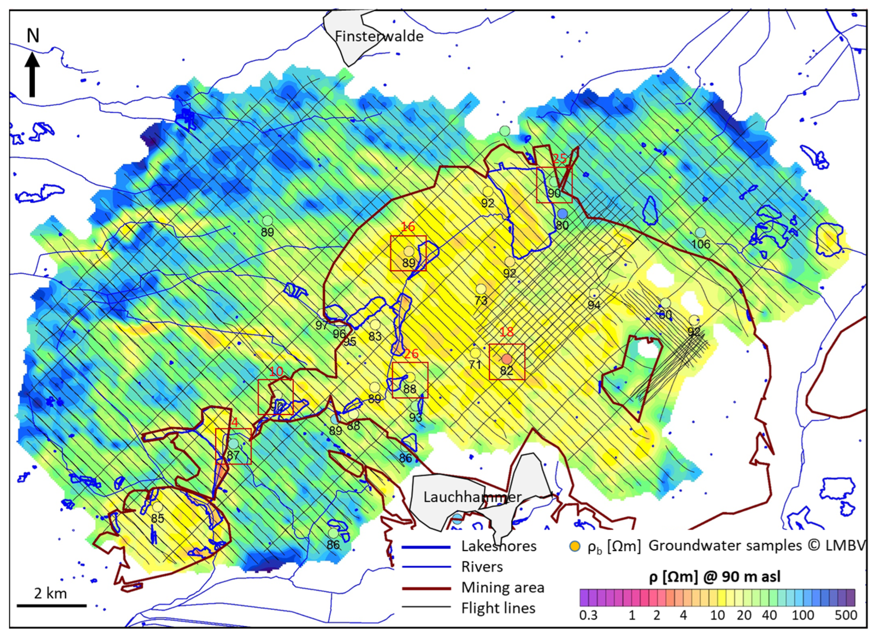

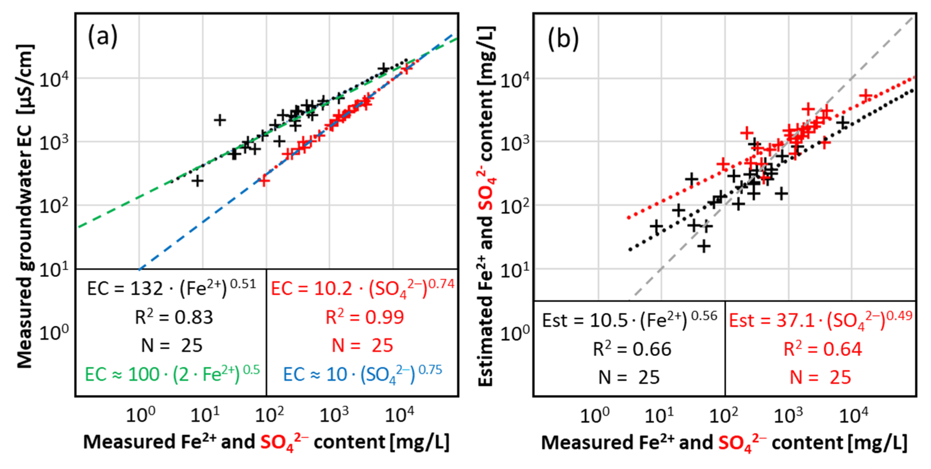
3.3.4. Groundwater Fe2+ and SO42− Content
4. Discussion
4.1. Methodological Validation
4.1.1. Positioning and Elevations
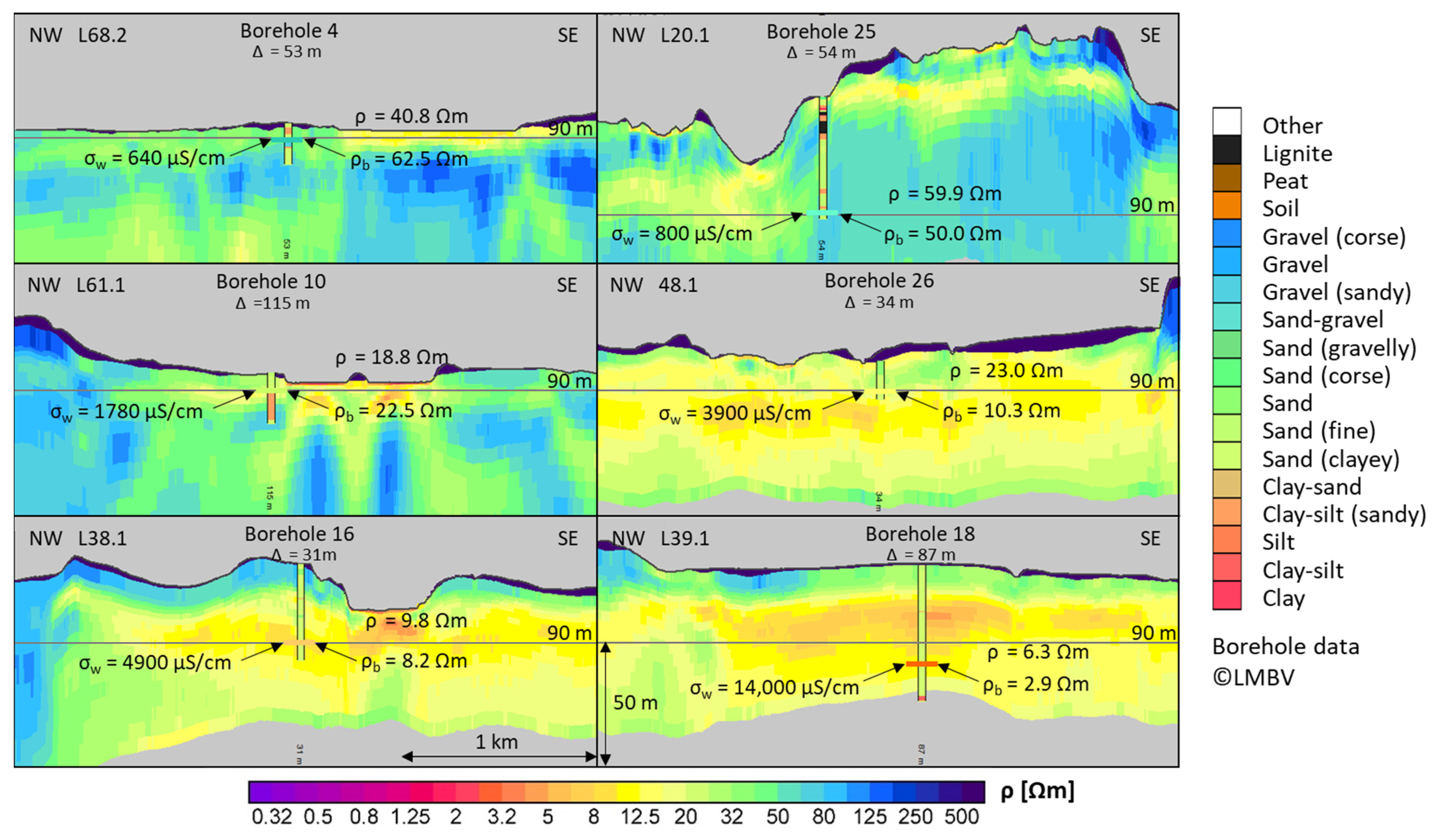
4.1.2. Resistivity Distribution
4.1.3. Water Table Estimation
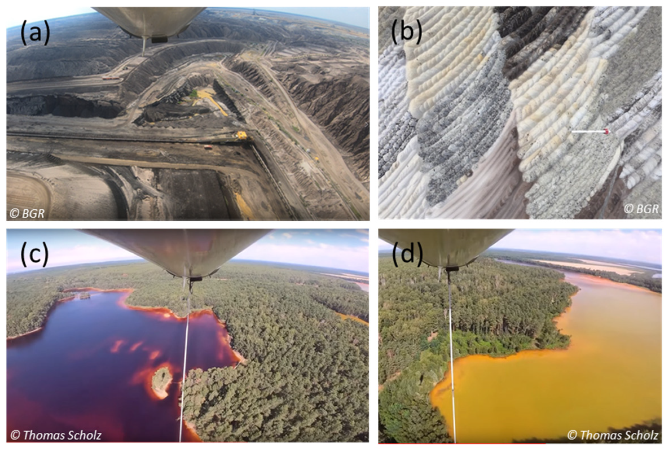
4.1.4. Contamination of Lakes and Groundwater
4.2. Comparison with Ground Data
5. Conclusions
- The regional water table was derived from the HEM resistivity models, which could be verified by measurements in lakes and boreholes.
- Significant variations in the water conductivity of the post-mining lakes were mapped using the apparent resistivities at the highest system frequency. For the larger lakes, the results are in good agreement with the conductivity measurements in the lakes. For smaller lakes, however, more detailed measurements (reduced flight line separation) and complex evaluations (modeling) are required.
- Water analyses in the study area showed that the electrical conductivity in the groundwater correlates with the content of dissolved Fe2+ and SO42−. This content could be estimated from airborne resistivity data at 90 m asl within the entire area of the former mining site. The results using a formation factor of F = 4 can be improved with the help of—if available—more borehole data (lithology) and improved techniques (e.g., machine learning), in order to better take into account the contribution of lithology to electrical conductivity and the distribution of the formation factor. However, here we have focused on using the borehole data only to verify the airborne results.
- The airborne results can also be used to close data gaps between boreholes, where information on the (hydro-)geological subsurface is often limited.
- The results of non-invasive airborne surveys are well suited for the (hydro-)geological description of post-mining landscapes. Once the airborne geophysical results have been evaluated, a uniform and extensive dataset is available that can be used to obtain valuable information on the (hydro-)geological subsurface conditions.
- The data resulting from the geophysical investigations can also be used as baseline data for further evaluation, interpretation, and modeling.
Supplementary Materials
Author Contributions
Funding
Data Availability Statement
Acknowledgments
Conflicts of Interest
Abbreviations
| AEM | Airborne Electromagnetic; |
| AMD | Acid Mine Drainage; |
| BGR | Bundesanstalt für Geowissenschaften und Rohstoffe; |
| BKG | Bundesamt für Kartographie und Geodäsie; |
| DEM | Digital Elevation Model; |
| EC | Electrical Conductivity; |
| GNSS | Global Navigation Satellite System; |
| GPS | Global Positioning System; |
| HEM | Helicopter-borne Electromagnetic; |
| IMU | Inertial Measurement Unit; |
| I, Q | In-phase, Quadrature of HEM data; |
| LBGR | Landesamt für Bergbau, Geologie und Rohstoffe Brandenburg; |
| LfU | Landesamt für Umwelt Brandenburg; |
| LMBV | Lausitzer und Mitteldeutsche Bergbau-Verwaltungsgesellschaft mbH; |
| PPP | Precise Point Positioning; |
| SG(E) | Depth (Elevation) of Steepest Gradient; |
| Topo | Terrain elevation. |
Appendix A
Appendix A.1

| Lake No | Northing [UTM33] | Easting [UTM33] | Water Level [m asl] | Est. Water Table Appr. I [m asl] | Est. Water Table Appr. II [m asl] |
|---|---|---|---|---|---|
| 1 | 416080 | 5714196 | 107.58 | 107.27 | 107.60 |
| 2 | 424875 | 5713288 | 119.02 | 113.61 | 119.15 |
| 3 | 409268 | 5708310 | 92.94 | 90.76 | 93.39 |
| 4 | 407034 | 5705210 | 92.52 | 88.76 | 92.41 |
| 5 | 408457 | 5708023 | 92.61 | 88.63 | 93.36 |
| 6 | 411421 | 5711155 | 101.29 | 97.97 | 98.89 |
| 7 | 410508 | 5711137 | 101.56 | 94.59 | 99.07 |
| 8 | 413098 | 5712787 | 102.66 | 102.72 | 102.81 |
| 9 | 423244 | 5713485 | 119.34 | 119.53 | 120.15 |
| 10 | 408881 | 5708436 | 92.67 | 91.25 | 93.53 |
| 11 | 412380 | 5710877 | 100.56 | 100.61 | 100.54 |
| 12 | 412320 | 5709099 | 99.33 | 93.81 | 98.66 |
| 13 | 411036 | 5708434 | 97.44 | 93.48 | 98.10 |
| 14 | 407034 | 5707796 | 92.52 | 91.83 | 92.72 |
| 15 | 405223 | 5705871 | 94.20 | 91.66 | 94.88 |
| 16 | 404084 | 5705046 | 96.32 | 93.43 | 98.76 |
| 17 | 419691 | 5714071 | 138.94 | 113.21 | 120.83 |
| 18 | 418632 | 5708286 | 119.80 | 107.02 | 107.28 |
| 19 | 409946 | 5708173 | 93.70 | 90.80 | 94.88 |
| 20 | 407158 | 5706486 | 92.52 | 89.54 | 92.09 |
| 21 | 412738 | 5707365 | 104.84 | 95.52 | 100.85 |
| 22 | 407088 | 5704322 | 92.21 | 86.46 | 91.98 |
| 23 | 405510 | 5707631 | 92.52 | 90.23 | 92.80 |
| 24 | 422670 | 5714770 | 123.43 | 122.12 | 121.07 |
| 25 | 410822 | 5704602 | 92.62 | 89.73 | 93.22 |
| 26 | 410414 | 5704994 | 92.65 | 87.82 | 92.59 |
| 27 | 413004 | 5708472 | 103.81 | 93.12 | 101.80 |
| 28 | 406637 | 5704145 | 91.99 | 88.82 | 92.70 |
| 29 | 421273 | 5714449 | 128.81 | 123.17 | 122.73 |
| 30 | 415396 | 5711040 | 109.43 | 107.57 | 110.52 |
| 31 | 417806 | 5715149 | 148.84 | 111.91 | 117.54 |
| 32 | 416107 | 5716223 | 120.51 | 104.89 | 106.81 |
| 33 | 410156 | 5711775 | 102.43 | 94.71 | 97.34 |
| 34 | 414676 | 5713710 | 105.02 | 101.66 | 105.59 |
| 35 | 414254 | 5709584 | 105.59 | 101.00 | 104.21 |
| 36 | 417106 | 5710541 | 110.74 | 107.71 | 111.20 |
| 37 | 415594 | 5711462 | 112.43 | 107.27 | 113.10 |
Appendix A.2
| Well No | Northing [UTM33] | Easting [UTM33] | Water Table [m asl] | Est. Water Table Appr. I [m asl] | Est. Water Table Appr. II [m asl] |
|---|---|---|---|---|---|
| 1 | 407023 | 5704111 | 92.22 | 86.50 | 91.98 |
| 2 | 419641 | 5708364 | 106.83 | 100.66 | 106.21 |
| 3 | 424099 | 5713756 | 127.58 | 120.44 | 123.11 |
| 4 | 414530 | 5715447 | 107.94 | 104.46 | 104.06 |
| 5 | 410553 | 5715591 | 104.76 | 94.80 | 98.46 |
| 6 | 415273 | 5713126 | 107.62 | 102.52 | 108.03 |
| 7 | 415112 | 5712697 | 107.62 | 102.73 | 108.95 |
| 8 | 415018 | 5712387 | 107.94 | 103.53 | 109.61 |
| 9 | 414585 | 5711045 | 107.20 | 106.06 | 109.33 |
| 10 | 419025 | 5713775 | 137.56 | 112.89 | 119.45 |
| 11 | 411577 | 5708382 | 101.33 | 94.84 | 99.76 |
| 12 | 414748 | 5714660 | 107.32 | 103.37 | 104.80 |
| 13 | 413295 | 5712061 | 105.08 | 102.99 | 104.12 |
| 14 | 412903 | 5711042 | 103.17 | 102.08 | 101.47 |
| 15 | 419053 | 5709379 | 108.73 | 109.60 | 112.57 |
| 16 | 419143 | 5711416 | 112.57 | 111.13 | 118.39 |
| 17 | 414495 | 5710654 | 106.78 | 105.21 | 107.88 |
| 18 | 420117 | 5708736 | 106.53 | 99.50 | 110.15 |
| 19 | 413001 | 5707117 | 104.56 | 95.40 | 100.84 |
| 20 | 411980 | 5710188 | 101.67 | 99.24 | 100.64 |
| 21 | 415455 | 5711643 | 109.08 | 106.84 | 112.89 |
| 22 | 421008 | 5706491 | 101.12 | 97.71 | 97.92 |
| 23 | 412607 | 5708680 | 101.82 | 93.18 | 101.16 |
| 24 | 412471 | 5709368 | 101.19 | 95.25 | 100.80 |
| 25 | 420643 | 5709384 | 106.99 | 103.85 | 114.87 |
| 26 | 420764 | 5709708 | 106.97 | 106.10 | 116.85 |
| 27 | 420878 | 5710433 | 109.81 | 111.34 | 119.50 |
| 28 | 413024 | 5707640 | 104.00 | 95.28 | 101.24 |
| 29 | 413166 | 5707696 | 103.65 | 95.37 | 101.29 |
| 30 | 413156 | 5708749 | 103.78 | 92.45 | 102.02 |
| 31 | 412858 | 5708433 | 102.58 | 93.32 | 101.64 |
| 32 | 416956 | 5712960 | 109.29 | 110.77 | 113.02 |
| 33 | 420006 | 5707440 | 104.28 | 96.67 | 100.63 |
| 34 | 414595 | 5709969 | 106.87 | 104.34 | 106.98 |
| 35 | 413139 | 5707506 | 104.24 | 95.52 | 101.11 |
| 36 | 411046 | 5708197 | 100.46 | 93.50 | 98.87 |
| 37 | 412786 | 5711663 | 103.37 | 102.20 | 102.45 |
| 38 | 413659 | 5713096 | 104.85 | 103.71 | 104.49 |
| 39 | 412188 | 5709852 | 101.28 | 98.54 | 100.87 |
| 40 | 422617 | 5710566 | 118.71 | 108.86 | 112.60 |
| 41 | 415409 | 5715924 | 109.15 | 104.58 | 104.84 |
| 42 | 410853 | 5708987 | 100.60 | 93.58 | 99.67 |
| 43 | 411371 | 5708068 | 101.25 | 94.61 | 99.53 |
| 44 | 411588 | 5708093 | 101.64 | 95.32 | 99.98 |
| 45 | 411386 | 5708190 | 101.19 | 94.55 | 99.58 |
| 46 | 413141 | 5707709 | 103.70 | 95.31 | 101.31 |
| 47 | 413204 | 5707818 | 104.73 | 95.28 | 101.43 |
| 48 | 413145 | 5707679 | 103.68 | 95.36 | 101.27 |
| 49 | 413132 | 5707357 | 104.62 | 95.51 | 101.01 |
| 50 | 412394 | 5707406 | 103.48 | 96.22 | 100.37 |
| 51 | 423133 | 5710928 | 119.15 | 107.73 | 113.56 |
| 52 | 422836 | 5710873 | 119.51 | 108.67 | 113.48 |
| 53 | 407584 | 5704631 | 92.36 | 85.82 | 91.37 |
| 54 | 410542 | 5708154 | 98.27 | 92.17 | 97.05 |
| 55 | 413862 | 5715540 | 107.88 | 104.37 | 104.01 |
| 56 | 415780 | 5716217 | 113.08 | 104.50 | 105.76 |
| 57 | 415998 | 5715885 | 109.08 | 105.48 | 106.19 |
| 58 | 413181 | 5714410 | 106.65 | 104.08 | 105.41 |
| 59 | 416897 | 5714958 | 108.69 | 108.69 | 110.60 |
| 60 | 414212 | 5715417 | 107.90 | 104.57 | 103.80 |
| 61 | 413837 | 5714737 | 107.36 | 103.85 | 103.90 |
| 62 | 409822 | 5709248 | 97.95 | 94.19 | 97.00 |
| 63 | 415025 | 5715942 | 108.89 | 104.17 | 104.00 |
| 64 | 415244 | 5715783 | 109.10 | 104.53 | 104.63 |
| 65 | 415224 | 5715781 | 109.06 | 104.51 | 104.60 |
| 66 | 415310 | 5715647 | 108.90 | 104.74 | 104.88 |
| 67 | 406466 | 5706827 | 93.75 | 90.24 | 93.64 |
| 68 | 414708 | 5713135 | 107.13 | 101.88 | 107.04 |
| 69 | 408711 | 5708486 | 95.73 | 91.70 | 94.67 |
| 70 | 408724 | 5708346 | 95.34 | 90.79 | 94.59 |
| 71 | 408688 | 5708253 | 93.63 | 90.20 | 94.02 |
Appendix A.3
| Lake No | Northing [UTM33] | Easting [UTM33] | EC [µS/cm] | ρw [Ωm] | ρa (Grid) [Ωm] | ρa (Line) [Ωm] | Distance [m] | Width [m] |
|---|---|---|---|---|---|---|---|---|
| 1 | 415912 | 5714464 | 2010 | 4.98 | 5.01 | 4.90 | 450 | 1200 |
| 2 | 413203 | 5712690 | 3110 | 3.22 | 4.11 | 3.50 | 100 | 600 |
| 3 | 412405 | 5711200 | 3240 | 3.09 | 2.59 | 2.90 | 250 | 500 |
| 4 | 411918 | 5711480 | 3240 | 3.09 | 6.41 | 3.20 | 100 | 400 |
| 5 | 410759 | 5710952 | 2730 | 3.66 | 24.99 | 4.20 | 50 | 200 |
| 6 | 412058 | 5709196 | 3330 | 3.00 | 7.82 | 3.00 | 50 | 400 |
| 7 | 414015 | 5709624 | 1350 | 7.41 | 27.71 | 13.60 | 50 | 140 |
| 8 | 410774 | 5708228 | 3370 | 2.97 | 14.63 | 4.00 | 50 | 140 |
| 9 | 413041 | 5708671 | 945 | 10.58 | 21.13 | 21.90 | 50 | 100 |
| 10 | 407217 | 5708036 | 788 | 12.69 | 13.86 | 13.50 | 250 | 800 |
| 11 | 405861 | 5707732 | 671 | 14.90 | 19.43 | 18.90 | 70 | 120 |
| 12 | 408857 | 5708066 | 2600 | 3.85 | 16.57 | 5.10 | 10 | 180 |
| 13 | 408717 | 5708140 | 3120 | 3.21 | 16.95 | 7.20 | 10 | 100 |
| 14 | 408007 | 5707465 | 3200 | 3.12 | 21.12 | 15.00 | 10 | 60 |
| 15 | 407218 | 5706502 | 2980 | 3.36 | 3.13 | 3.20 | 130 | 350 |
| 16 | 407043 | 5705132 | 2530 | 3.95 | 4.73 | 4.10 | 250 | 300 |
| 17 | 405060 | 5705669 | 2730 | 3.66 | 15.60 | 6.30 | 50 | 120 |
| 18 | 406960 | 5704493 | 2370 | 4.22 | 10.75 | 11.00 | 10 | 60 |
| 19 | 419735 | 5714201 | 379 | 26.39 | 29.07 | 27.00 | 100 | 400 |
| 20 | 424912 | 5713076 | 2070 | 4.83 | 4.14 | 4.50 | 240 | 600 |
| 21 | 423374 | 5713202 | 908 | 11.01 | 25.60 | 12.40 | 50 | 450 |
| 22 | 412847 | 5707389 | 2380 | 4.20 | 7.70 | 4.10 | 10 | 400 |
Appendix A.4
| Well No | Northing [UTM33] | Easting [UTM33] | EC [µS/cm] | ρw [Ωm] | ρ (90 m asl) [Ωm] | Fe2+ [mg/L] | SO42− [mg/L] | Est. Fe2+ [mg/L] | Est. SO42− [mg/L] |
|---|---|---|---|---|---|---|---|---|---|
| 1 | 412857 | 5708433 | 1029 | 9.43 | 27.82 | 162 | 511 | 103 | 753 |
| 2 | 420131 | 5711427 | 1853 | 5.46 | 16.74 | 138 | 1030 | 285 | 1483 |
| 3 | 420965 | 5710926 | 3000 | 3.37 | 15.05 | 318 | 2000 | 353 | 1709 |
| 4 | 421150 | 5713476 | 764 | 13.16 | 26.89 | 67 | 329 | 111 | 788 |
| 5 | 407545 | 5707330 | 638 | 15.62 | 40.77 | 32 | 257 | 48 | 453 |
| 6 | 408541 | 5713823 | 993 | 10.31 | 41.58 | 51 | 381 | 46 | 441 |
| 7 | 411677 | 5710796 | 2920 | 3.44 | 17.56 | 470 | 2040 | 259 | 1391 |
| 8 | 414595 | 5709969 | 3650 | 2.78 | 14.87 | 535 | 2550 | 362 | 1736 |
| 9 | 411046 | 5708197 | 2400 | 4.20 | 19.21 | 282 | 1610 | 217 | 1234 |
| 10 | 408817 | 5708747 | 1790 | 5.62 | 18.80 | 287 | 1100 | 226 | 1270 |
| 11 | 418061 | 5711706 | 2620 | 3.77 | 20.51 | 181 | 1380 | 190 | 1131 |
| 12 | 410132 | 5711115 | 2120 | 4.88 | 22.97 | 285 | 1330 | 152 | 972 |
| 13 | 410638 | 5710867 | 2200 | 4.69 | 30.97 | 19 | 1280 | 83 | 653 |
| 14 | 410935 | 5710643 | 1260 | 7.87 | 24.47 | 87 | 690 | 134 | 894 |
| 15 | 412659 | 5712930 | 4810 | 2.04 | 9.75 | 1390 | 4050 | 842 | 3048 |
| 16 | 414757 | 5711834 | 3020 | 3.33 | 9.33 | 296 | 2040 | 919 | 3233 |
| 17 | 415511 | 5709795 | 14150 | 0.71 | 6.34 | 7160 | 16600 | 1990 | 5411 |
| 18 | 405339 | 5705494 | 2540 | 4.00 | 16.11 | 245 | 1410 | 308 | 1561 |
| 19 | 411662 | 5708975 | 2600 | 3.85 | 15.96 | 534 | 1760 | 314 | 1580 |
| 20 | 410526 | 5708046 | 650 | 17.54 | 17.79 | 30 | 221 | 253 | 1367 |
| 21 | 414960 | 5714673 | 3740 | 2.70 | 13.51 | 435 | 2790 | 438 | 1973 |
| 22 | 415597 | 5712629 | 4360 | 2.33 | 11.69 | 803 | 3590 | 585 | 2393 |
| 23 | 417129 | 5714026 | 247 | 41.49 | 41.57 | 8 | 93 | 46 | 441 |
| 24 | 416896 | 5714959 | 802 | 12.50 | 59.92 | 47 | 405 | 22 | 271 |
| 25 | 412690 | 5709263 | 3870 | 2.56 | 23.05 | 770 | 3730 | 151 | 968 |
References
- von Bismarck, F. Land in motion–opencast restoration and recultivation in Lusatia. In Post-Mining Landscape, Conference Documentation; Internationale Bauausstellung (IBA) Fürst-Pückler-Land, Ed.; Jovis: Berlin, Germany, 2010; pp. 37–41. ISBN 978-3-86859-043-2. [Google Scholar]
- Krümmelbein, J.; Bens, O.; Raab, T.; Anne Naeth, M. A history of lignite coal mining and reclamation practices in Lusatia, eastern Germany. Can. J. Soil Sci. 2012, 92, 53–66. [Google Scholar] [CrossRef]
- Drebenstedt, C.; Kuyumcu, M. (Eds.) Braunkohlesanierung: Grundlagen, Geotechnik, Wasserwirtschaft, Brachflächen, Rekultivierung, Vermarktung; Springer: Berlin/Heidelberg, Germany, 2014. [Google Scholar] [CrossRef]
- Benthaus, F.-C.; Totsche, O. The groundwater raise in lignite mining induced areas in Lusatia–actions taken to reduce the follows ups. Min. Rep. 2015, 151, 522–530. Available online: https://mining-report.de/wp-content/uploads/2015/11/MiRe_1506_Grundwasserwiederanstieg_151124.pdf (accessed on 12 February 2025).
- Frei, S.; Klostermann, L.; Gilfedder, B.S. Iron retention in Lusatia: A spatially differentiated analysis of the Spree. Grundwasser 2024, 29, 213–228. [Google Scholar] [CrossRef]
- Schultze, M.; Pokrandt, K.-H.; Hille, W. Pit lakes of the Central German lignite mining district: Creation, morphometry and water quality aspects. Limnologica 2010, 40, 148–155. [Google Scholar] [CrossRef]
- Gläßer, C.; Groth, D.; Frauendorf, J. Monitoring of hydrochemical parameters of lignite mining lakes in Central Germany using airborne hyperspectral casi-scanner data. Int. J. Coal Geol. 2011, 86, 40–53. [Google Scholar] [CrossRef]
- Bamisaiye, O.A. Subsurface mapping: Selection of best interpolation method for borehole data analysis. Spat. Inf. Res. 2018, 26, 261–269. [Google Scholar] [CrossRef]
- Gondolfo, O.C.B. Determination of water table depth using geophysical methods. Braz. J. Geophys. 2022, 40, 1–15. [Google Scholar] [CrossRef]
- King, A.R.; Hynes, T. Applications of geophysical methods for monitoring acid mine drainage. In Proceedings of the International Land Reclamation and Mine Drainage Conference and the Third International Conference on the Abatement of Acidic Drainage, Pittsburgh, PA, USA, 24 April 1994; pp. 317–326. [Google Scholar] [CrossRef]
- Shokri, B.J.; Ardejani, F.D.; Ramazi, H.; Moradzadeh, A. Predicting pyrite oxidation and multi-component reactive transport processes from an abandoned coal waste pile by comparing 2D numerical modeling and 3D geo-electrical inversion. Int. J. Coal Geol. 2016, 164, 13–24. [Google Scholar] [CrossRef]
- Moreira, C.A.; Casagrande, M.F.S.; Büchi, F.M.S.; Targa, D.A. Hydrogelogical characterization of a waste rock pile and bedrock affected by acid mine drainage from geophysical survey. SN Appl. Sci. 2020, 2, 1236. [Google Scholar] [CrossRef]
- Kirsch, R. (Ed.) Groundwater Geophysics—A Tool for Hydrogeology; Springer: Berlin, Heidelberg, Germany, 2006. [Google Scholar] [CrossRef]
- Paine, J.G.; Minty, B.R.S. Airborne hydrogeophysics. In Hydrogeophysics; Rubin, Y., Hubbard, S.S., Eds.; Springer: Dordrecht, The Netherlands, 2005; pp. 333–357. [Google Scholar] [CrossRef]
- Siemon, B.; Ibs-von Seht, M.; Steuer, A.; Deus, N.; Wiederhold, H. Airborne electromagnetic, magnetic, and radiometric surveys at the German North Sea coast applied to groundwater and soil investigations. Remote Sens. 2020, 12, 1629. [Google Scholar] [CrossRef]
- Harrison, E.J.; Baranwal, V.C.; Pfaffhuber, A.A.; Christensen, C.W.; Skurdal, G.H.; Rønning, J.S.; Anschütz, H.; Brönner, M. AEM in Norway: A Review of the Coverage, Applications and the State of Technology. Remote Sens. 2021, 13, 4687. [Google Scholar] [CrossRef]
- Knight, R.; Smith, R.; Asch, T.; Abraham, J.; Cannia, J.; Viezzoli, A.; Fogg, G. Mapping aquifer systems with airborne electromagnetics in the Central Valley of California. Groundwater 2018, 56, 893–908. [Google Scholar] [CrossRef]
- Jørgensen, F.; Møller, M.M.; Nebel, L.; Jensen, N.-P.; Christiansen, A.V.; Sandersen, P.B.E. A method for cognitive 3D geological voxel modelling of AEM data. Bull. Eng. Geol. Environ. 2023, 72, 421–432. [Google Scholar] [CrossRef]
- Høyer, A.-S.; Jørgensen, F.; Foged, N.; He, X.; Christiansen, A.V. Three-dimensional geological modelling of AEM resistivity data—A comparison of three methods. J. Appl. Geophys. 2015, 115, 65–78. [Google Scholar] [CrossRef]
- Marker, P.A.; Foged, N.; He, X.; Christiansen, A.V.; Refsgaard, J.C.; Auken, E.; Bauer-Gottwein, P. Performance evaluation of groundwater model hydrostratigraphy from airborne electromagnetic data and lithological borehole logs. Hydrol. Earth Syst. Sci. 2015, 19, 3875–3890. [Google Scholar] [CrossRef]
- King, J.; Mulder, T.; Essink, G.O.; Bierkens, M.F.P. Joint estimation of groundwater salinity and hydrogeological parameters using variable-density groundwater flow, salt transport modelling and airborne electromagnetic surveys. Adv. Water Res. 2022, 160, 104118. [Google Scholar] [CrossRef]
- Siemon, B.; Christiansen, A.V.; Auken, E. A review of helicopter-borne electromagnetic methods for groundwater exploration. Near Surf. Geophys. 2009, 7, 629–646. [Google Scholar] [CrossRef]
- Auken, E.; Boesen, T.; Christiansen, A.V. Chapter Two—A review of airborne electromagnetic methods with focus on geotechnical and hydrological applications from 2007 to 2017. Adv. Geophys. 2017, 58, 47–93. [Google Scholar] [CrossRef]
- Hammack, R.; Love, E.; Veloski, G.; Ackman, T.; Harbert, W. Using helicopter electromagnetic surveys to identify environmental problems at coal mines. Mine Water Environ. 2003, 22, 80–84. [Google Scholar] [CrossRef]
- Love, E.; Hammack, R.; Harbert, W.; Sams, J.; Veloski, G.; Ackman, T. Using airborne thermal infrared imagery and helicopter EM conductivity to locate mine pools and discharges in the Kettle Creek watershed, north-central Pennsylvania. Geophysics 2005, 70, B73–B91. [Google Scholar] [CrossRef]
- Demirel, N.; Emil, M.K.; Duzgun, H.S. Surface coal mine area monitoring using multi-temporal high-resolution satellite imagery. Int. J. Coal Geol. 2011, 86, 3–11. [Google Scholar] [CrossRef]
- Schroeter, L.; Gläβer, C. Analyses and monitoring of lignite mining lakes in Eastern Germany with spectral signatures of Landsat TM satellite data. Int. J. Coal Geol. 2011, 86, 27–39. [Google Scholar] [CrossRef]
- Siemon, B.; Ibs-von Seht, M.; Pielawa, J. Gebietsbericht D-AERO-Finsterwalde HEM/HMG/HRD-Befliegung 191 Finsterwalde Mai/Juli 2021; Bundesanstalt für Geowissenschaften und Rohstoffe: Hannover, Germany, 2022. [Google Scholar] [CrossRef]
- LBGR. Geologische Übersichtskarte 1:100000 (GÜK100); Landesamt für Bergbau, Geologie und Rohstoffe: Cottbus, Germany, 2015; Available online: https://geo.brandenburg.de/?page=Geologische-Karten (accessed on 11 November 2024).
- BKG. Digitale Topographische Karte 1:1000000 (DTK1000); Bundesamt für Kartographie und Geodäsie: Frankfurt, Germany, 2021; Topographic Map Generated From: Spatial Data Base: ©GeoBasis-DE/BKG (2021); Available online: https://gdz.bkg.bund.de/index.php/default/catalog/product/view/id/1454/s/digitale-topographische-karte-1-100-000-dtk100 (accessed on 11 November 2024).
- LfU. Gewässernetz; Landesamt für Umwelt Brandenburg: Potsdam, Germany, 2024; Available online: https://data.geobasis-bb.de/geofachdaten/Wasser/Hydrologie/gewnet25.zip (accessed on 11 November 2024).
- LMBV. Bergbaufolgeseen; Lausitzer und Mitteldeutsche Bergbau-Verwaltungsgesellschaft mbH: Senftenberg, Germany, 2024; Available online: https://lmbv.maps.arcgis.com/apps/webappviewer/index.html?id=64068d71103d40a9a0a07f6b0682db1c&extent=1425029.5094%2C6647119.0691%2C1718547.698%2C6795254.0299%2C102100&showLayers=Wasser_View_5083%3BUeberleiter_View_2598 (accessed on 11 November 2024).
- LMBV. Landinanspruchnahme; Lausitzer und Mitteldeutsche Bergbau-Verwaltungsgesellschaft mbH: Senftenberg, Germany, 2024; Available online: https://geodatenportal-lmbv.hub.arcgis.com/maps/62bfad18b48244eebc81bca44f337cb8 (accessed on 11 November 2024).
- Standke, G.; Rascher, J.; Volkmann, N. Lowstand cycles and coal formation in paralic environments: New aspects in sequence statigraphy. In Northern European Cenozoic Stratigraphy—Proceedings of the 8th Biannual Meeting of the RCNNS/RCNPS; Guers, K., Ed.; Landesamt für Natur und Umwelt des Landes Schleswig-Holstein: Flintbek, Germany, 2002; pp. 153–161. [Google Scholar]
- Barth, W.; Bönisch, R.; Krentz, O.; Kühner, R.; Lapp, M.; Petzold, H.; Schneider, W.; Schulze, H.; Seibel, B.; Standke, G. Die geologische Entwicklung der Lausitz; Vattenfall Europe Mining AG: Cottbus, Germany, 2010. [Google Scholar]
- Stackebrandt, W.; Franke, D. Geologie von Brandenburg; Schweizerbart Science Publishers: Stuttgart, Germany, 2015; ISBN 978-3-510-65295-2. [Google Scholar]
- LfU. Grundwassermessnetz; Landesamt für Umwelt Brandenburg: Potsdam, Germany; Available online: https://maps.brandenburg.de/WebOffice/synserver?project=GWM_www_CORE (accessed on 14 February 2025).
- Christiansen, A.V.; Auken, E. A global measure for depth of investigation. Geophysics 2012, 77, WB171–WB177. [Google Scholar] [CrossRef]
- Tølbøll, R.J.; Christensen, N.B. Sensitivity functions of frequency-domain magnetic dipole-dipole systems. Geophysics 2007, 72, F45–F56. [Google Scholar] [CrossRef]
- Siemon, B.; van Baaren, E.; Dabekaussen, W.; Delsman, J.; Dubelaar, W.; Karaoulis, M.; Steuer, A. Automatic identification of fresh-saline groundwater interfaces from airborne electromagnetic data in Zeeland, the Netherlands. Near Surf. Geophys. 2019, 17, 3–25. [Google Scholar] [CrossRef]
- Siemon, B.; Steuer, A.; Ullmann, A.; Vasterling, M.; Voß, W. Application of frequency-domain helicopter-borne electromagnetics for groundwater exploration in urban areas. Phys. Chem. Earth 2011, 36, 1373–1385. [Google Scholar] [CrossRef]
- Siemon, B. Improved and new resistivity-depth profiles for helicopter electromagnetic data. J. Appl. Geophys. 2001, 46, 65–76. [Google Scholar] [CrossRef]
- Sengpiel, K.-P.; Siemon, B. Advanced inversion methods for airborne electromagnetic exploration. Geophysics 2000, 65, 1983–1992. [Google Scholar] [CrossRef]
- Annetts, A.; George, R.; Munday, T.; Ibrahimi, T.; Cahill, K.; Paul, R.; Davis, A. The application of AEM to mapping sea-water intrusion at La Grange, WA. In Proceedings of the ASEG-PESA 2015, Perth, Australia, 15–18 February 2015. [Google Scholar] [CrossRef]
- BKG. Digitales Geländemodel (DGM25); Bundesamt für Kartographie und Geodäsie: Frankfurt, Germany, 2021; Spatial Data Base: ©GeoBasis-DE/BKG (2021); Available online: https://gdz.bkg.bund.de (accessed on 1 February 2012).
- LMBV. Lithology Data, Water Table Data, Hydrochemical Data; Personal communication; adapted with permission from LMBV (27 January 2025); Lausitzer und Mitteldeutsche Bergbau-Verwaltungsgesellschaft mbH: Senftenberg, Germany, 2022. [Google Scholar]
- Kang, S.; Knight, R.; Greene, T.; Buck, C.; Fogg, G. Exploring the model space of airborne electromagnetic data to delineate largescale structure and heterogeneity within an aquifer system. Water Resour. Res. 2021, 57, e2021WR029699. [Google Scholar] [CrossRef]
- Archie, G.E. The electrical resistivity log as an aid in determining some reservoir characteristics. Trans. AIME 1942, 146, 54–62. [Google Scholar] [CrossRef]
- Yin, C.-C.; Ren, X.-Y.; Liu, Y.-H.; Qi, Y.-F.; Qiu, C.-K.; Cai, J. Review on airborne electromagnetic inverse theory and applications. Geophysics 2015, 80, W17–W31. [Google Scholar] [CrossRef]
- Brodie, R.; Sambridge, M. Holistic inversion of frequency-domain airborne electromagnetic data with minimal prior information. Explor. Geophys. 2009, 40, 8–16. [Google Scholar] [CrossRef]


| Dataset | Reference | Type | Extent | Resolution | Time |
|---|---|---|---|---|---|
| DEM | BKG [45] | Grid | Germany | 25 m | 2012 |
| Topography | BKG [30] | Polylines | Germany | - | |
| Water table/level | LMBV [46] | Points | Local | - | 2021-07 |
| Water quality | LMBV [46] | Points | Local | - | 2021-07 |
| Stream topography | LfU [31] | Polylines | Brandenburg | - | |
| Lake topography | LMBV [32] | Polygons | Brandenburg | - | |
| Mining area | LMBV [33] | Polylines | Brandenburg | - | |
| Borehole/well data | LMBV [46] | Points | Brandenburg | - |
| Elevation Parameter | Number | Lakes Δ [m] | σ [m] | Number | Wells Δ [m] | σ [m] | Number | Total Δ [m] | σ [m] | ||
|---|---|---|---|---|---|---|---|---|---|---|---|
| da | 37 | 0.80 | 1.71 | 71 | 7.36 | 8.42 | 108 | 5.11 | 7.56 | ||
| da_sel | 34 | 0.67 | 1.54 | 55 | 5.66 | 6.44 | 89 | 3.75 | 5.68 | ||
| dam | 37 | 0.32 | 1.97 | 71 | 3.87 | 6.69 | 108 | 2.65 | 5.78 | ||
| dam_sel | 34 | 0.25 | 1.89 | 55 | 2.69 | 4.56 | 89 | 1.76 | 3.94 | ||
| d1(6) | 37 | 1.26 | 2.03 | 71 | 7.78 | 8.06 | 108 | 5.54 | 7.32 | ||
| d1(6)_sel | 34 | 1.10 | 1.81 | 55 | 6.14 | 6.45 | 89 | 4.22 | 5.73 | ||
| d1(20) | 37 | 1.19 | 1.74 | 71 | 6.74 | 7.61 | 108 | 4.83 | 6.77 | ||
| d1(20)_sel | 34 | 0.79 | 1.91 | 55 | 6.05 | 6.49 | 89 | 4.04 | 5.81 |
| Elevation Parameter | Number | Lakes Δ [m] | σ [m] | Number | Wells Δ [m] | σ [m] | Number | Total Δ [m] | σ [m] | ||
|---|---|---|---|---|---|---|---|---|---|---|---|
| SGE-I | 37 | −5.71 | 7.22 | 71 | −5.39 | 3.88 | 108 | −5.50 | 5.24 | ||
| SGE-I_sel | 34 | −4.20 | 3.59 | 55 | −5.19 | 3.12 | 89 | −4.81 | 3.32 | ||
| SGE-II | 37 | −2.44 | 6.56 | 71 | −1.39 | 3.92 | 108 | −1.75 | 4.98 | ||
| SGE-II_sel | 34 | −1.02 | 3.43 | 55 | −0.47 | 3.21 | 89 | −0.68 | 3.29 | ||
| Topo-SE | 37 | 1.11 | 1.82 | 71 | −0.04 | 3.75 | 108 | 0.35 | 3.26 | ||
| Topo-SE_sel | 34 | 1.01 | 1.69 | 55 | 0.48 | 2.51 | 89 | 0.68 | 2.24 |
Disclaimer/Publisher’s Note: The statements, opinions and data contained in all publications are solely those of the individual author(s) and contributor(s) and not of MDPI and/or the editor(s). MDPI and/or the editor(s) disclaim responsibility for any injury to people or property resulting from any ideas, methods, instructions or products referred to in the content. |
© 2025 by the authors. Licensee MDPI, Basel, Switzerland. This article is an open access article distributed under the terms and conditions of the Creative Commons Attribution (CC BY) license (https://creativecommons.org/licenses/by/4.0/).
Share and Cite
Siemon, B.; Cortés Arroyo, O.; Janetz, S.; Nixdorf, E. Benefits of an Airborne Electromagnetic Survey of Former Opencast Lignite Mining Areas in Lusatia, Germany. Water 2025, 17, 1000. https://doi.org/10.3390/w17071000
Siemon B, Cortés Arroyo O, Janetz S, Nixdorf E. Benefits of an Airborne Electromagnetic Survey of Former Opencast Lignite Mining Areas in Lusatia, Germany. Water. 2025; 17(7):1000. https://doi.org/10.3390/w17071000
Chicago/Turabian StyleSiemon, Bernhard, Olaf Cortés Arroyo, Silvio Janetz, and Erik Nixdorf. 2025. "Benefits of an Airborne Electromagnetic Survey of Former Opencast Lignite Mining Areas in Lusatia, Germany" Water 17, no. 7: 1000. https://doi.org/10.3390/w17071000
APA StyleSiemon, B., Cortés Arroyo, O., Janetz, S., & Nixdorf, E. (2025). Benefits of an Airborne Electromagnetic Survey of Former Opencast Lignite Mining Areas in Lusatia, Germany. Water, 17(7), 1000. https://doi.org/10.3390/w17071000