1. Introduction
Climate change and rapid urbanization have exacerbated flood risks in the complex street networks of urban areas, thereby endangering lives in coastal cities [
1]. In this context, the concept of flood vulnerability has gained significant attention for its utility in providing insights from the perspective of the affected entities, thereby informing disaster prevention and mitigation management. Policymakers and researchers worldwide are consequently striving to enhance urban resilience and post-disaster recovery capacities [
2]. China has experienced numerous disasters throughout its history, including floods. Urban areas, in particular, face heightened flood risks due to increasingly extreme weather events and anthropogenic activities [
3]. As a vital and economically dynamic city in Zhejiang Province, Wenzhou requires enhanced flood resilience in its highly vulnerable zones, supplementing traditional disaster prevention measures to manage its escalating flood risk.
Flood risk is generally defined as a function of hazard, exposure, and vulnerability [
4]. Each of these components is subject to various uncertainties, stemming from input data, spatialization processes, and model structures [
5,
6]. While numerous studies have explored the spatiotemporal variations in hazards and exposure at local, regional, and global scales, the understanding of flood vulnerability remains limited and requires further refinement [
3,
7,
8]. Constructing a vulnerability framework necessitates the selection of multiple appropriate indices tailored to regional specificities. Even within an identical assessment framework, indices may vary across studies from different regions, as the first law of geography dictates that regional characteristics, data availability, and computational complexity are inherently spatial-dependent [
9]. Although flood risk has been studied for decades, a consensus on its assessment methodology remains elusive. Current flood risk assessment methods can be categorized into five groups: those based on historical flood maps, scenario-based numerical simulations, remote sensing, machine learning, and indices. Among these, index-based methods are the most widely used due to their simplicity and feasibility in characterizing risk across different scales [
10,
11]. However, while straightforward and efficient for rapid assessment, these methods often lack the capacity to evaluate flood risk impacts from multiple perspectives. The convergence of disciplines and the open-source sharing of data have now made the integrated application of the above methods possible, demonstrating considerable potential. Owing to diverse perceptions of flood risk, researchers have proposed various index systems and frameworks to explain it from different angles [
12,
13]. For example, Wang et al. [
14] coupled statistical methods, machine learning models, and clustering algorithms to investigate landslide susceptibility in Ningnan County, Liangshan Mountain; Yin et al. [
15] assessed the hydrological resilience of a sub-city area in Beijing by coupling the MIKE21 model; and Xu et al. [
16] developed a framework for assessing dynamic flood risk indicators by integrating the Telemac2D hydrodynamic model with statistical methods such as TOPSIS, CRITIC, and GIS. Consequently, there is a pressing need to synergize and integrate existing methodologies to establish a comprehensive framework for reducing street-level flood risk in urban areas.
Current vulnerability assessment practices often operate at a significantly coarser resolution than the scale at which actual impacts occur. This discrepancy introduces substantial uncertainty into the estimates, whereas finer-resolution data have been shown to markedly improve the overall accuracy of risk assessments [
17,
18]. Given the complexity of flood initiation and propagation, simplistic vulnerability index methods may be inadequate for capturing the spatial nuances of vulnerability. Hydrodynamic modeling, in contrast, facilitates the mechanistic simulation of flood disasters. It can chain simulations across the causation, development, and propagation stages to generate quantitative indicators—such as water depth and flow velocity—at a higher spatiotemporal resolution. Leveraging these advantages, a growing body of research has applied hydrodynamic models to flood resilience and risk assessment [
2,
19,
20]. Therefore, it is imperative to develop a more scientifically robust flood vulnerability assessment framework for complex coastal city streets, building upon previous studies and incorporating hydrodynamic modeling.
Vulnerability serves as a core element in allocating flood control resources and provides crucial data support for the decision-making process [
21]. Existing studies generally concur that flood vulnerability can intuitively reflect a region’s susceptibility to flooding and its potential adverse impacts [
22]. As a decision-making reference, vulnerability assessments can effectively guide the implementation of flood control measures and optimize the allocation of resources [
23,
24]. Through accurate vulnerability assessment, targeted measures can be deployed during the disaster prevention phase to reduce casualties and property losses, which aligns with the core objective of modern flood management [
25]. Currently, some studies are attempting to allocate flood control resources based on vulnerability quantitatively. For example, Jun. J. et al. [
26] utilized a flood vulnerability index to prioritize flood control investments, ensuring equity in fund distribution, while W. Yang et al. [
27] allocated flood control funds based on multidimensional vulnerability to improve usage efficiency. Zhong et al. [
28] quantitatively allocated flood prevention funds based on social vulnerability assessments under historical conditions, spatialized the allocated funds and their generated benefits, and evaluated the effectiveness of different disaster prevention measures. However, in constructing their vulnerability frameworks, many existing studies on quantitative resource allocation characterize the flood hazard by relying primarily on long-term time series or static spatial indicators (e.g., using average annual precipitation as a proxy for flood intensity or topography alone to infer flood susceptibility) [
27]. While valuable for regional screening, such approaches often neglect the intrinsic, dynamic characteristics of a flood process, such as spatially and temporally varying water depth and velocity resulting from a specific rainfall event. In contrast, hydrodynamic models can quantitatively describe flood dynamics at a fine granularity (such as water depth and flow velocity) [
16], revealing more fundamental flood characteristics while clearly illustrating the interactions between flood processes and disaster prevention measures. Furthermore, most studies are constrained by historical conditions and overlook the future evolution of flood dynamics over time. To address this issue, the development of future land-use prediction models (e.g., PLUS, FLUS) [
29,
30] now enables pre-disaster flood prevention fund allocation from a future-oriented perspective. This approach not only allows for more accurate responses to changes in flood hazards but also strongly supports sustainable urban development, helping cities achieve their sustainability goals [
31].
This study integrates high-resolution hydrodynamic modeling with future land-use scenarios to achieve dynamic flood vulnerability assessment, thereby enabling a forward-looking and dynamic optimization of flood prevention fund allocation that considers both current urban flood vulnerability and future urban development. Specific objectives include: (1) Establishing a hydrological–hydrodynamic model tailored to urban characteristics by integrating future land-use scenarios; (2) Developing a flood vulnerability assessment framework using the hydrodynamic model to evaluate vulnerability from both current and future perspectives; (3) Constructing a dynamic funding allocation optimization model integrating future vulnerability projections to quantitatively evaluate optimized flood control resource allocation. This ensures disaster prevention resources address current risks while building long-term resilience against future flood threats. This end-to-end methodology, spanning mechanism simulation and forward-looking financial planning, provides scientifically rigorous and sustainable strategies for urban flood risk management.
5. Conclusions
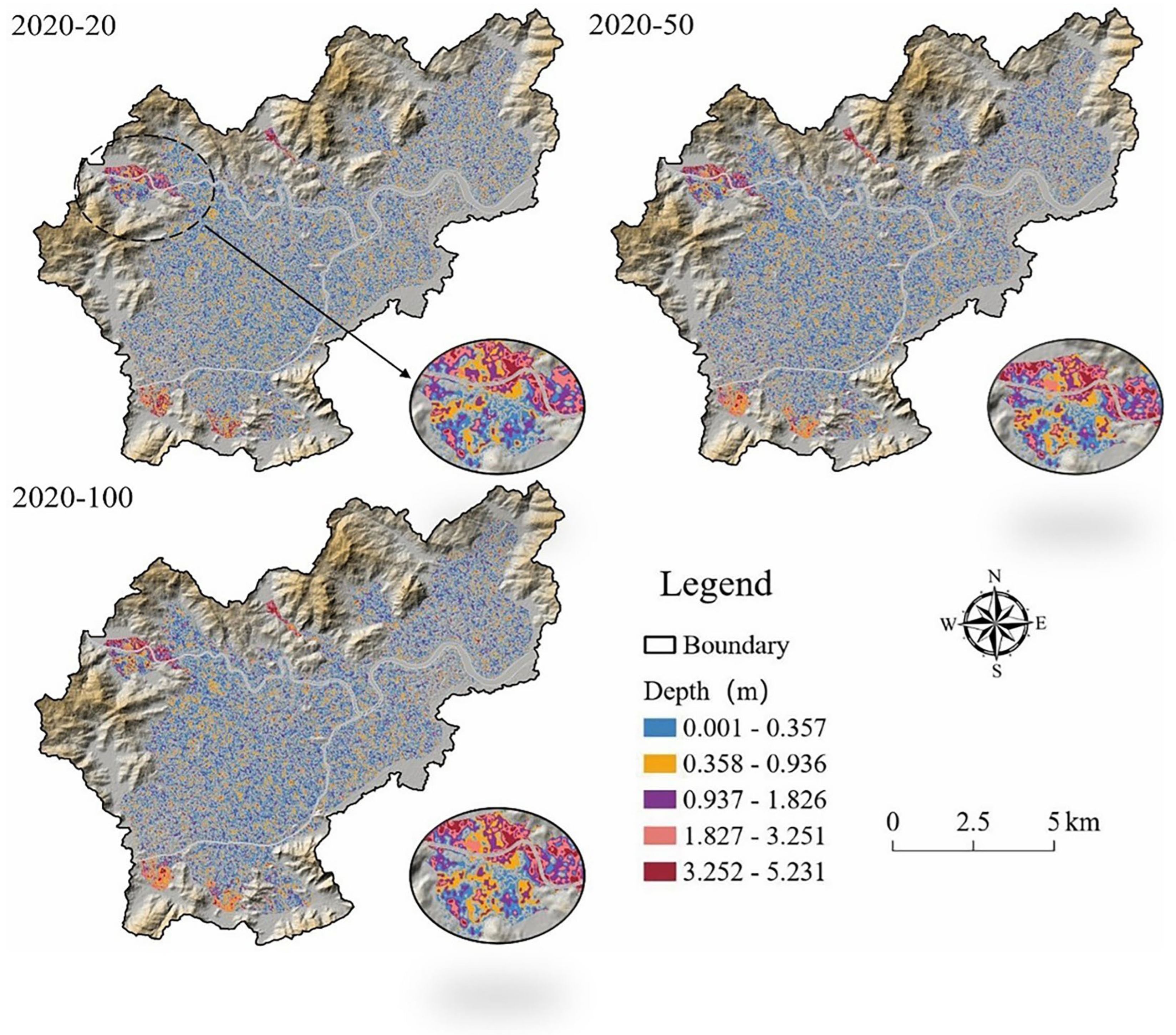
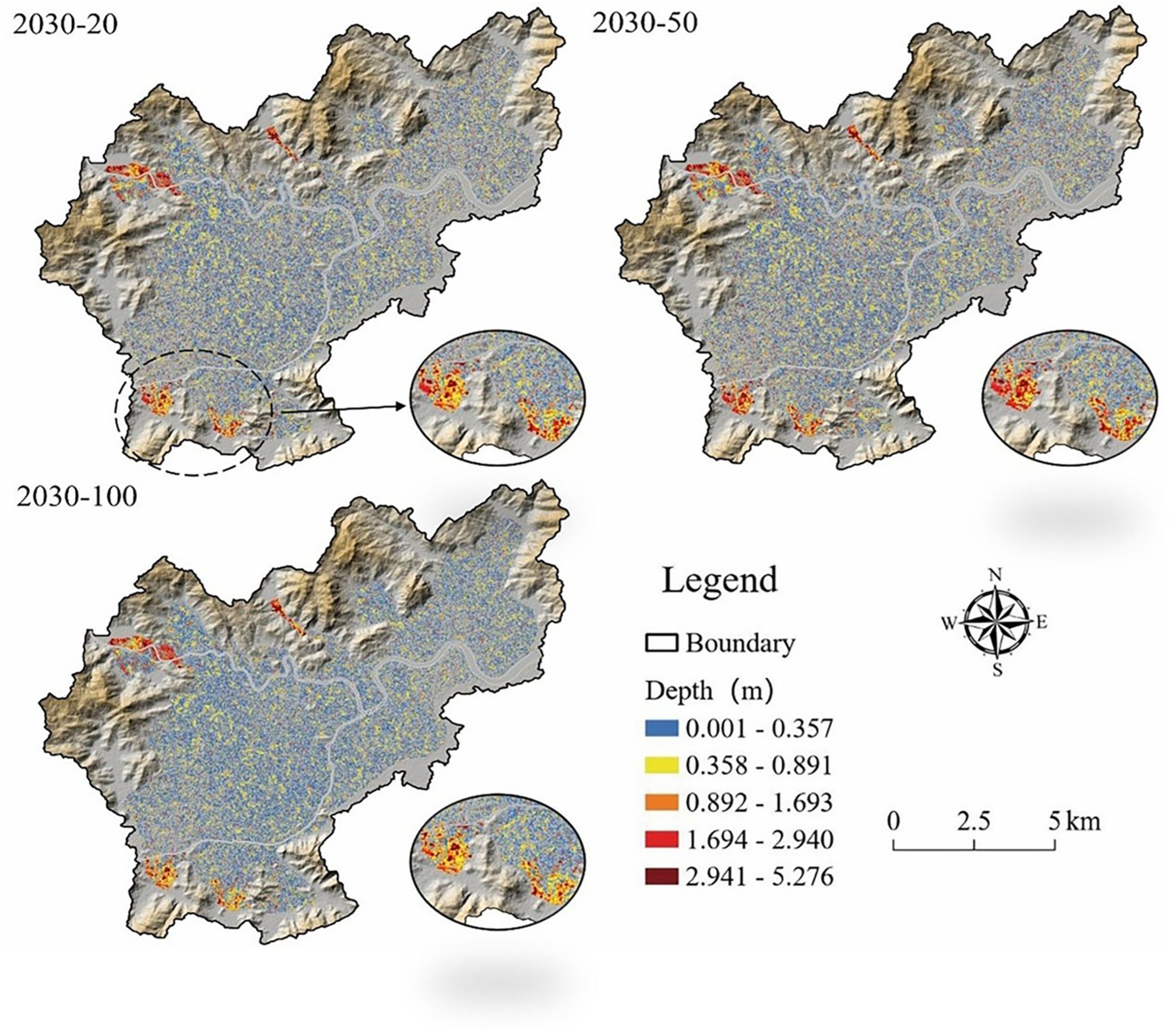
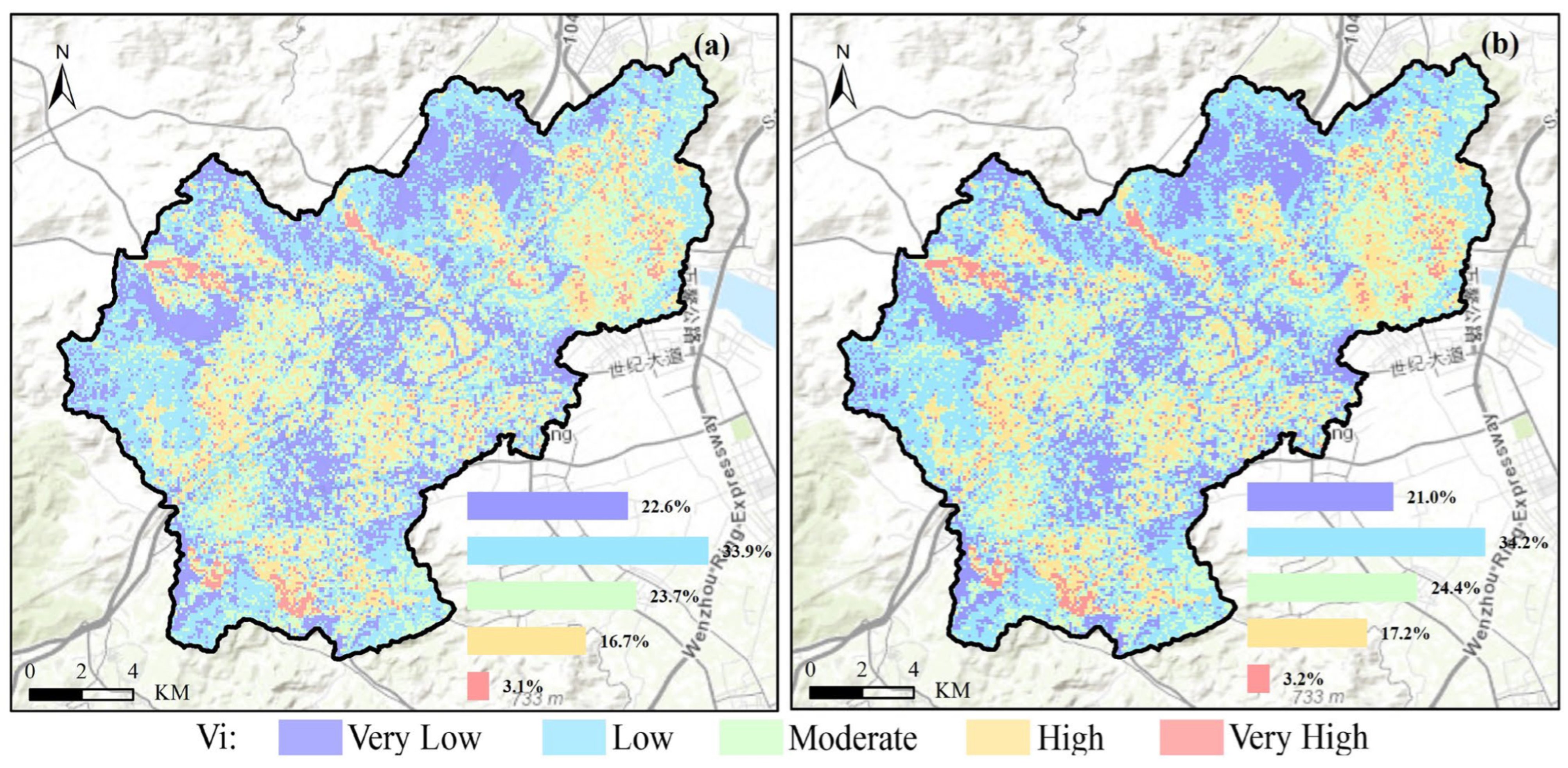
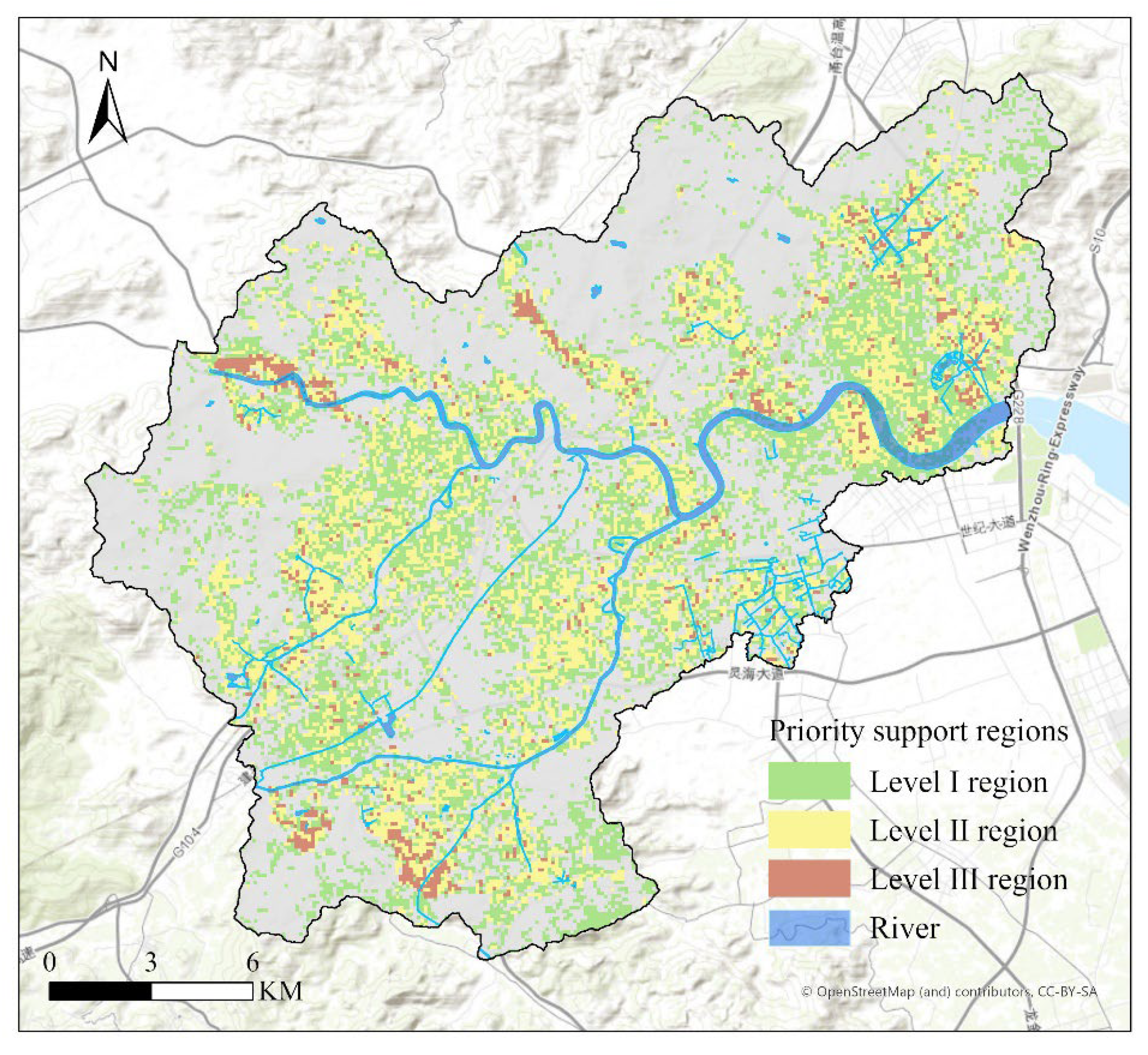
The study analyzed the spatial heterogeneity of flood vulnerability based on social vulnerability to floods (VHCF) combined with hydrodynamic modeling, and explored the changes in vulnerability areas between 2020 and 2030. The results show that the very high vulnerability areas are mainly concentrated in riverine towns, while the high vulnerability areas are mainly distributed in dense urban areas. Specifically, the very high vulnerability areas in 2020 are mainly concentrated in riverine towns and low-lying areas in the southern, northwestern, and northern parts of the study area, which are usually densely populated, with many buildings and fragile infrastructures, and are exposed to a higher risk of flood inundation. With the accelerated urbanization and the impact of climate change, the proportion of high vulnerability areas will increase in 2030, which suggests that the risk of flooding will increase in the future.
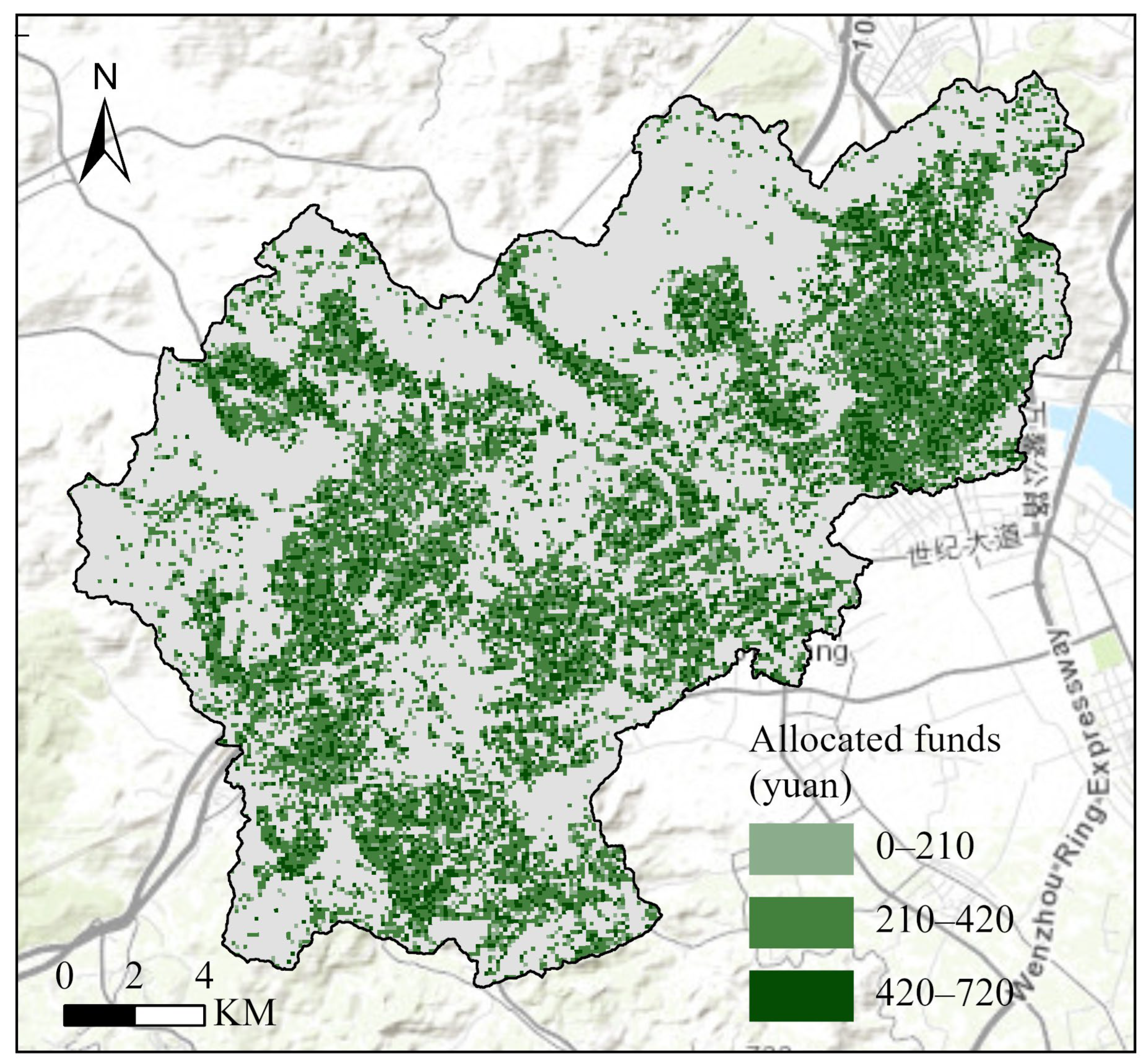
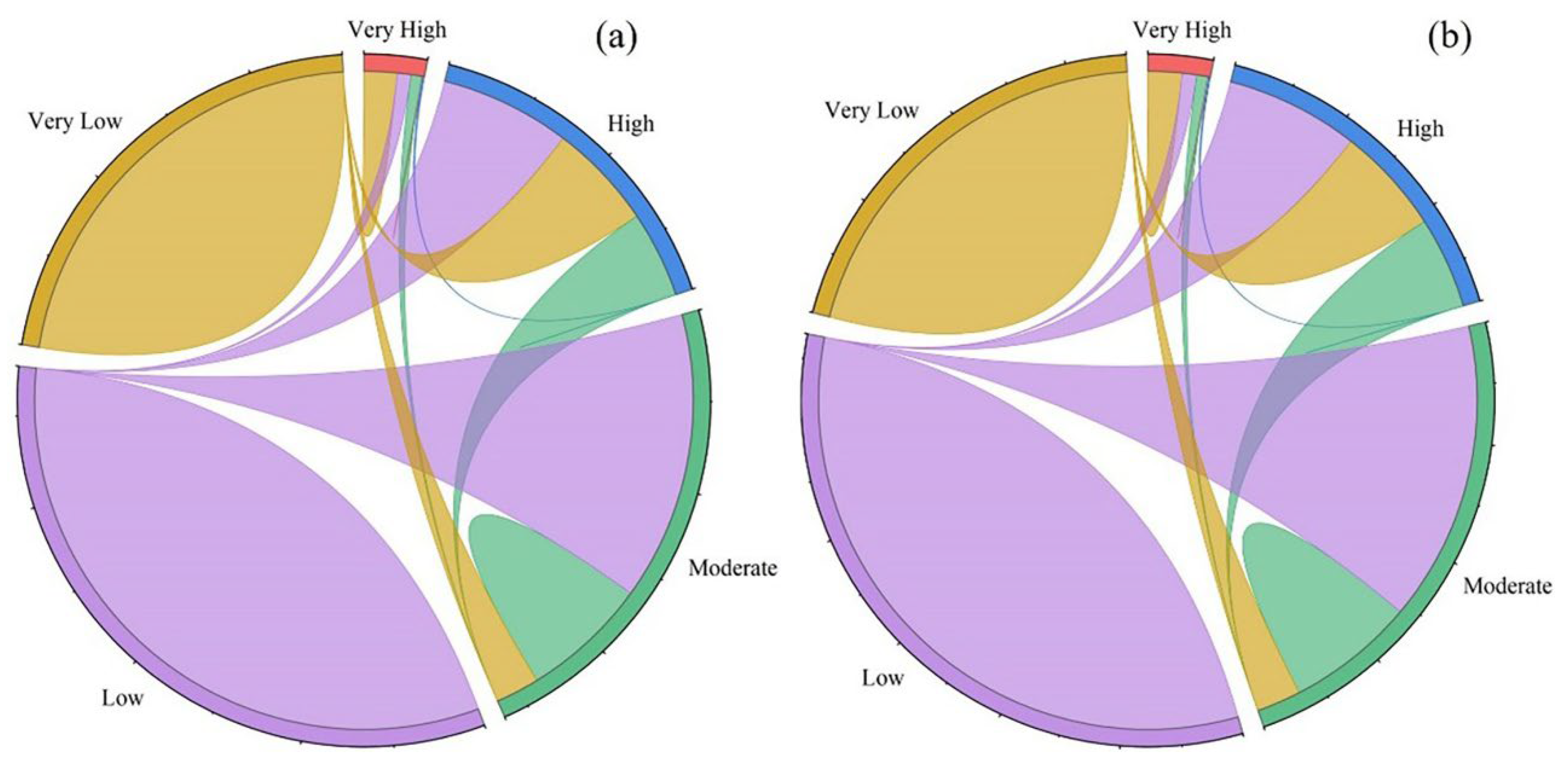
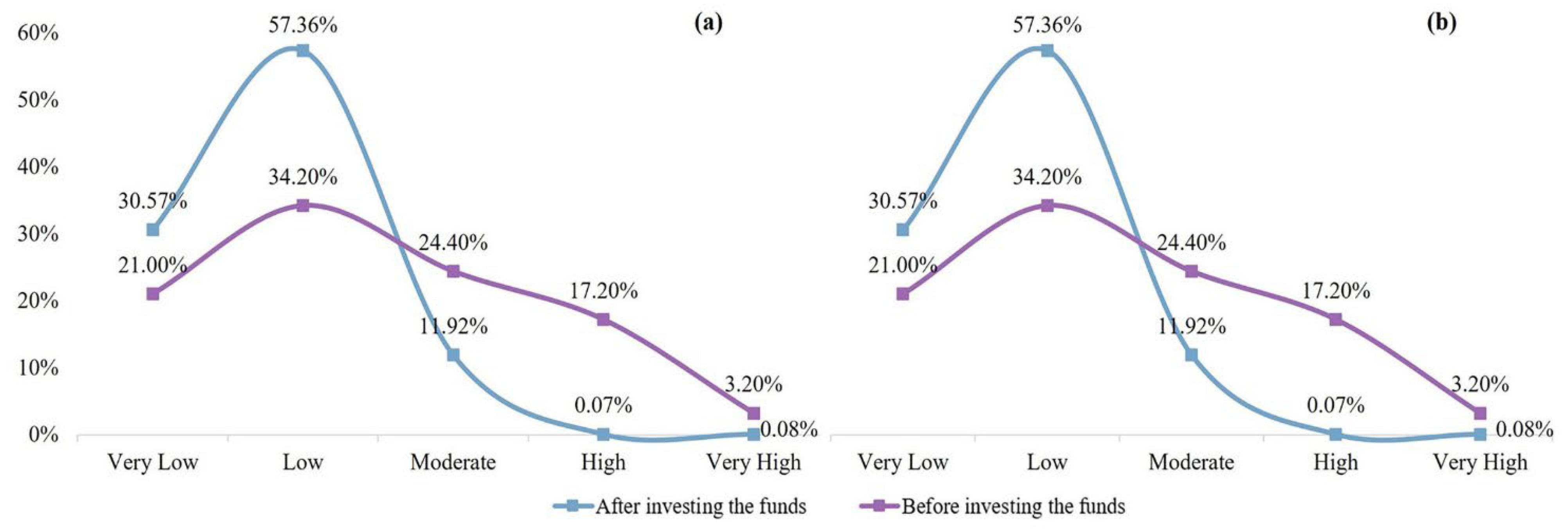
A pre-disaster funding allocation model is proposed based on VHCF by combining the vulnerability assessment of hydrological and hydrodynamic processes, aiming to optimize the allocation of disaster prevention resources and maximize the benefits of disaster prevention measures. The results show that the current and future vulnerability assessments can effectively identify highly vulnerable areas and provide a scientific basis for funding allocation. The optimized current and future perspectives account for 88.29% and 87.93% of the number of low and very low vulnerability areas, respectively. By introducing the future perspective, the VHCF-FAOM model not only improves the current flood prevention capacity but also ensures that future disaster prevention resources can effectively respond to changing climate conditions and disaster risks. In conclusion, the integration of current and future perspectives in disaster prevention fund allocation was shown to not only improve the efficiency of fund utilization and avoid wastage of resources but also promote the sustainable enhancement of urban disaster resilience.
However, there are some limitations of this study, mainly in terms of data availability and modeling complexity. Future studies could consider introducing more indicators and higher spatial resolution to provide a more refined reference for funding optimization. A more comprehensive analysis could provide decision-makers with more targeted recommendations to more effectively address the challenges posed by flood hazards.

