Article

Renaturalization Drives Hydromorphological Recovery in Degraded Gravel-Bed Streams in Poland

Institute of Nature Conservation, Polish Academy of Sciences, Al. A. Mickiewicza 33, 31-120 Kraków, Poland
Water 2025, 17(22), 3315; https://doi.org/10.3390/w17223315
Submission received: 19 October 2025 / Revised: 13 November 2025 / Accepted: 18 November 2025 / Published: 20 November 2025

Abstract

The systematic regulation of Polish gravel-bed watercourses, notably intensified in the latter half of the 20th century, coupled with extensive gravel extraction, have become one of the main factors leading to severe channel incision and degradation of hydromorphological features. This paper investigates river renaturalization as a pivotal strategy to restore channel-riparian water connectivity in incised gravel-bed streams of Southern Poland. The river restoration projects were categorized into passive and active techniques. Passive methods, though less common, involve cost-effective methods like the restoration of erodible corridors, island-braided channel patterns, and woody debris presence, while active methods include mainly fish passes, check dam lowering, and artificial riffles. A total of 27 major activities carried out on rivers of Southern Poland were assessed, revealing a trend towards comprehensive renaturalization in collaboration with scientists, pro-environment organizations, and local authorities and communities. Despite the lack of long-term data for most projects, results demonstrated sustained improvements in hydromorphological features, including the shallowing and stabilization of deeply incised channels. Using a natural section of the Czarny Dunajec river, a brief case study was presented to explain the mechanism of spontaneous river renaturalization. It was also shown that a good restoration project should take into account the views of all river stakeholders, anticipate possible development trajectories of a freely migrating river, and assess the potential benefits for both nature and people. Increased deposition of macroplastics together with woody debris in naturally widened river sections, as well as the possible remobilization of pollutants previously trapped in bank sediments, presents an additional challenge for future projects.

1. Introduction

Rivers in dynamic equilibrium, free from transverse hydraulic structures like dams or weirs, exhibit three-dimensional connectivity within their ecosystems: along the river’s course, with the riparian zone, and with the hyporheic zone, which includes the permanently water-saturated alluvium [1,2]. This connectivity can be restored through various modifications to river channels and riparian zones, aiming to enhance the geomorphic, hydrological, and ecological characteristics of degraded watersheds [3,4].
In recent years, researchers and practitioners have identified effective approaches for river restoration, tailored to the size of catchments and the specific features targeted for restoration [5]. Nearly one and a half thousand significant interventions have been documented on European rivers [6]. These figures do not include the many local initiatives driven by angling or environmental communities. However, these actions are often misunderstood by local water authorities, who tend to prioritize the maintaining of an existing regulation infrastructure. Additionally, local communities often envision “river revitalization” as regulating rivers to prevent overflow during significant floods or making the riparian zone simply “pleasing to the eye”. Consequently, the core principle of river restoration—achieving rivers safe from flooding and in good hydromorphological and ecological condition—is sometimes overlooked.
River regulations in Poland, both ad hoc and lacking legal regulations, have been documented since the 17th century [7]. Since the latter half of the 19th century onward, systematic efforts were initiated, primarily directed towards inland navigation, irrigation, agricultural land acquisition, as well as mills and sawmills [8]. In the second half of the 20th century, increasing anthropogenic pressure on river areas was expressed through permanent, heavy regulation of river channels, removal of live vegetation and woody debris, changes in catchment usage, and uncontrolled large-scale gravel extraction [9]. This quickly led to a number of detrimental effects, such as (i) increase in flood peaks [10], (ii) loss of geomorphic dynamic equilibrium [11], (iii) reduced complexity of riparian habitats [12], and (iv) deterioration in fish biocoenoses [13].
Recent studies show also that in inhabited areas these ecosystems are heavily contaminated with macroplastics (plastic particles > 5 mm) [14,15]. This pollution can harm riverine organisms through ingestion and entanglement and reduce the aesthetic value of mountain river landscapes. The presence of macroplastics in river channels also accelerates their fragmentation, producing secondary microplastics that pollute mountain water resources [16]. Moreover, macroplastics are deposited together with wood debris in wide, multi-stream sections of rivers, which are exceptionally valuable habitats [15]. As a result, the benefits that mountain rivers provide to nearby human populations may be diminished [17]. The problem is particularly acute in populated sections of mountain catchments, where residential and transport infrastructure is concentrated along flat valley floors, creating multiple sources of macroplastic emissions and facilitating their entry into river channels [18].
Rapid erosion of sediments carries another serious risk—the release of hazardous substances trapped in them. For example, a release of chemicals or organic matter into water would further affect already disturbed (fragmented) biota assemblages [19]. Waste stored in the rivers fragments during floods and releases another portion of harmful substances entering living organisms or polluting water intakes. Pollution from watersheds, especially from large cities and agricultural areas, affects water chemistry and suspended sediments, limiting river ecosystem services [20]. More than half of the world’s river basins have undergone major anthropogenic changes impacting fish biodiversity [20]. Additionally, there are a number of studies confirming the negative impact of pollutants released from rivers on the reproduction of organisms, e.g., Ref. [21].
Undoubtedly, the most dangerous phenomenon is river incision, which has been observed in every Carpathian watercourse and ranges from 1.0 to nearly 4.0 m [11]. This process continues to occur today and, in addition to the previously mentioned effects, it causes headward and lateral erosion (posing a threat to hydraulic structures), destruction of the hyporheic zone (which functions within the gravel riverbed), and the lowering of the surface water table (Figure 1).
In the second half of the 20th century, when the consequences of these issues were recognized, a wide range of river restoration techniques was developed. As a result, Polish mountain rivers, especially those heavily impacted by human activity, have experienced (and still continue to experience) improvements in hydromorphological and biotic parameters. These improvements have been achieved through projects partly adapted from those used on rivers in Eastern Europe and North America and partly developed specifically for the conditions of Polish rivers. Existing publications present in detail the results of individual remedial actions on rivers.
The incentive to implement the above-mentioned projects is the implementation of the provisions of the EU Water Framework Directive (WFD), which has the primary goal to achieve good ecological and chemical status for all surface and groundwater bodies, including rivers, within the shortest possible timeframe—initially by 2015, and in justified cases by 2027. Water management is organized at the level of river basin districts through River Basin Management Plans, which define environmental objectives, corrective measures, and implementation schedules. The approach goes beyond reducing chemical pollution; it also emphasizes improving ecological conditions by restoring natural hydromorphological processes such as river meandering and enabling the migration of aquatic organisms. Effective river governance requires integration with other sectors—agriculture, forestry, transport, and spatial planning—since the state of water bodies depends on a range of environmental and economic factors. Continuous monitoring of water quality and quantity, regular progress assessments, and the periodic revision of management plans are essential, alongside strict prevention of further deterioration. River management under the WFD prioritizes the preservation and restoration of natural river functions, avoiding excessive channel regulation, renaturalizing floodplains, and maintaining ecological flows that support aquatic life. All actions must follow the principle of sustainable development, ensuring that present generations use water resources without compromising their availability and quality for the future. In exceptional cases where achieving good status within the prescribed timeframe is not feasible, the Directive allows justified exemptions—provided that remedial actions are implemented and the public is actively involved in the planning process.
The current condition of Polish rivers, however, remains poor. According to WWF Poland (Warsaw, Poland), only about 3% of rivers are in good ecological status, while European Commission data indicate that approximately 8.4% of all surface waters in Poland meet the “good status” criteria [22]. The Supreme Audit Office of Poland (Warsaw, Poland)) further reports that, by the end of 2021, as many as 99.5% of surface water bodies had not achieved good status [23]. This means that only a small fraction of Polish rivers currently comply with the WFD’s objectives, and improving their ecological and chemical quality remains one of the country’s most pressing environmental challenges. Due to the lack of existing publications summarizing comprehensively the restoration actions undertaken on the rivers in Southern Poland, this paper aims to present the types of revitalization and renaturalization techniques (including self-renaturalization) currently being undertaken on these watercourses, as well as to assess future perspectives for further improving their condition. Contemporary threats to Carpathian rivers and potential ways of preventing them were also presented. This paper may additionally serve as a useful reference for the future evaluation of river restoration projects.

2. Materials and Methods

2.1. River Revitalization and Renaturalization

The concepts of river revitalization and river renaturalization (commonly named ‘river restoration’) are often used interchangeably, although each has distinct focuses and methodologies. Generally, most authors adopt the term ‘renaturalization’ as a superior concept, returning a river system to a state as close as possible to its natural, pre-disturbance conditions [24,25], while ‘revitalization’ rather includes urban and community-oriented goals, such as improving recreational opportunities, aesthetics, and economic benefits alongside ecological health [26]. On the other hand, according to the US Environmental Protection Agency (Washington, DC, USA), the term revitalization is overarching [27]. According to the currently applicable standard PN-EN 14614 [28], river restoration is understood as the restoration of natural features not only within the channel (as per the previous law), but especially of the riparian corridor, generally much wider than the channel itself [29,30]. The application of this new standard has recently allowed for replacing the standard description of reference channels developed by Rosgen [31] with a more comprehensive hydromorphological characterization of river channel size and type, main-channel bed, channel margins, and floodplains [29].

2.2. Analyzed Projects

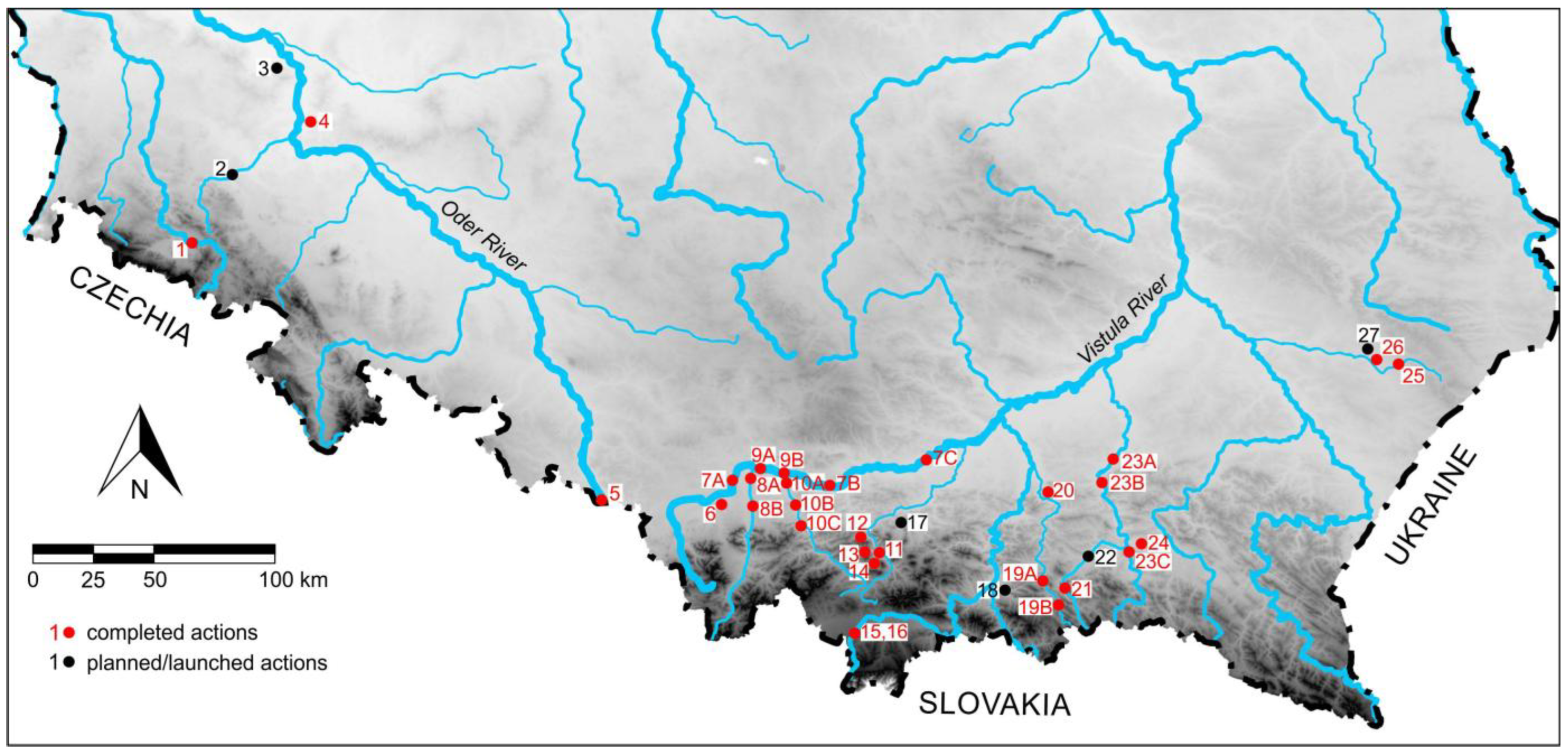
For the analysis, all major projects conducted on the rivers of Southern Poland were collected and classified based on their impact on the river as either ‘revitalization’ (local action) or ‘renaturalization’ (more comprehensive action within the river corridor). Locations of the analyzed actions are shown in Figure 2, and their characteristics are shown in Table 1. Regardless of the above criterion, the projects were assigned to two groups:
(i)
Passive restoration techniques, e.g., erodible corridor, restoring the presence of vegetated islands, woody debris, and multi-thread channel patterns;
(ii)
Active restoration techniques, e.g., check dam/concrete weirs lowering, construction of fish passes, artificial riffles, roughened riffles and honeycomb-shape riffles, and reactivation of blocked braids.
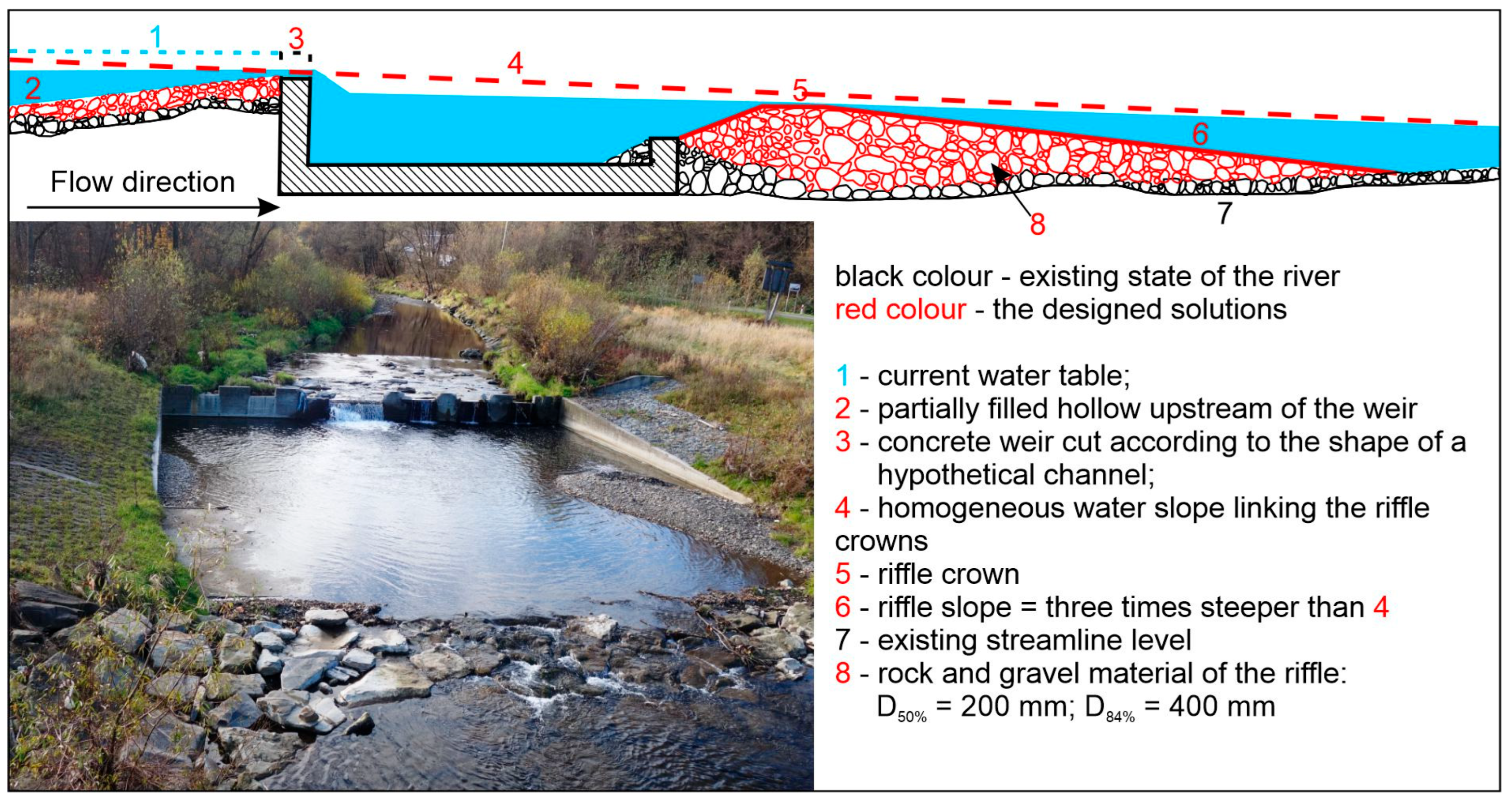
Examples of and techniques for actions taken within the above groups were presented, and their impact on the abiotic and biotic parameters of the given stream was assessed. The use of artificial riffles in river restoration was discussed in more detail, with their design following the river equilibrium equations according to Thorne and Hey [32]. The equilibrium equations of Thorne and Hey, transformed according to the studies by Jeleński [33], and Jeleński and Wyżga [34], allow for determining the critical slope (S), width, and depth of the balanced river channel (W) and (di), as well as the distance between the crowns of riffles (z) for the assumed bankfull discharge (QB), riffle grain size (Di), and sediment transport rate (Qs) (Figure 3). Additionally, the unit stream power (ω) is provided to illustrate the energy of the water flow present under these conditions. Calculations are performed for different sediment grain size scenarios.

2.3. Different Project Scales—One Goal

Even a cursory knowledge of river restoration shows that these projects are carried out on various scales, often very locally. Undoubtedly, restoration goals under the EU Water Framework Directive can only be achieved when measures address the root causes of degradation across the basin, not just the visible symptoms in a single reach.
In practice, however, large-scale, comprehensive restoration initiatives are relatively rare in Poland. Major projects aimed at removing high migration barriers, creating free migration corridors, or constructing fish passes require multi-million euro funding and are typically supported through external European programs (e.g., Polish–Swiss or Polish–Norwegian initiatives). When successful, these projects allow rivers to regain their natural character—at least for the duration of the project’s maintenance period.
The vast majority of activities, however, consist of smaller, more localized projects, often grassroots initiatives undertaken by NGOs and other river stakeholders. After positive evaluation, they are carried out with limited support from external funds or local water authorities whose budgets are usually very constrained. The value of such local restoration interventions lies in their multiplicity—combining dispersed actions over time into a broader, cumulative outcome—and in their long-term sustainability, fostered by the commitment of local nature enthusiasts and angling associations.

2.4. Case Study on the Czarny Dunajec River

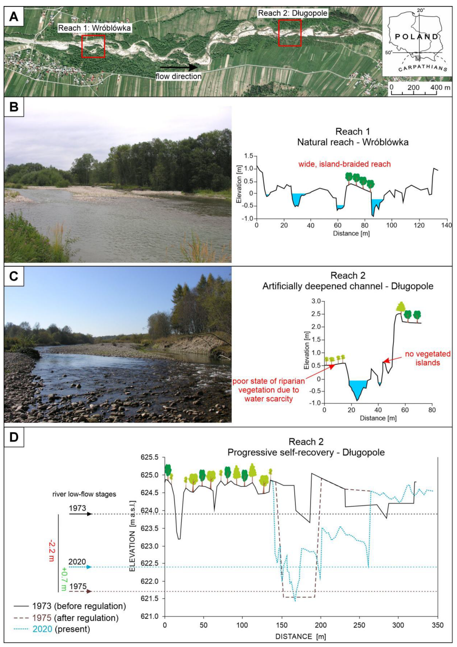
Additionally, an analysis was conducted on the impact of artificial deepening of the Czarny Dunajec riverbed in its multi-thread Wróblówka-Długopole section on the water level and the condition of riverine and riparian vegetation. For this purpose, a comparison of contemporary cross-sectional analyses (2020) with those performed during regulatory works in the 1970s was carried out. The construction plan for the river channelization [35] presented planform geometry of the pre- and post-regulation channels together with their cross-sections. The contemporary geometry of the river channel and floodplain in the cross-section was then surveyed with a level. The surveying also allowed us to determine in greater detail the morphology of the left-bank terrace overgrown with riparian forest that has not changed since the river channelization in the mid-1970s. The formation of the artificially incised channel caused the cessation of overbank flows in the channelized reach, evidenced by the lack of fine-grained overbank sediments above the gravelly sediments deposited in the channel active before the river channelization. The existence of these exposed sediments from the regulation period allowed for an easy comparison of the riverbed levels before regulation, after regulation, and in the present day. For contrast, one cross-section through a natural, multi-thread section upstream of the regulated site was measured and presented.

2.5. Restoration Requires True Interdisciplinarity

Professional river restoration projects demand a high level of interdisciplinary collaboration and careful planning supported by extensive field measurements. Advanced computer models are used to simulate hydrological and geomorphological processes, predict river behavior, and optimize restoration designs. However, these models rely on accurate field data. Therefore, detailed topographic and bathymetric surveys are carried out using GPS, total stations, and drones equipped with LiDAR or photogrammetric cameras to capture the shape of the river channel and floodplain. Flow velocity and discharge are measured with current meters or acoustic Doppler devices (ADCP), while sediment samples are collected to analyze grain size and transport dynamics. Water quality parameters—such as temperature, dissolved oxygen, and nutrient concentrations—are also monitored to assess ecological conditions.
Fluvial geomorphologists interpret these data to understand sediment transport, erosion, and deposition patterns, ensuring that the restored river system remains stable and functions naturally. Biologists evaluate aquatic and riparian habitats to enhance biodiversity and ecological resilience. Designers translate scientific insights into practical, visually coherent, and environmentally sensitive restoration plans. Contractors implement these plans in the field, often adjusting to real-time conditions. Finally, the involvement of the local community is crucial—their knowledge of the river, their needs, and their long-term engagement contribute to the project’s acceptance, maintenance, and lasting success. All this is preceded by careful planning and project preparation, securing funding, and holding discussions with NGOs and local residents. These early stages often include allocating space for the river’s natural dynamics and ensuring access routes for heavy equipment.

3. Results

Among the 27 presented restoration efforts, 7 were classified as comprehensive renaturalization efforts, while 20 represented more localized revitalization activities (Table 1). The high density of restoration measurements in some regions (e.g., “The Upper Raba River Spawning Grounds” project restoring the Raba river, including its important tributaries) reflects the successful collaboration between NGOs and scientists with local water authorities in implementing restoration projects co-financed by national and European funds. The hydrological regime of all presented rivers is pluvial-nival with rapid, short-lived floods after storms or snowmelt during spring to autumn and typical low-flows during winter and late summer. A description of the actions taken along with a brief outline of the hydrological characteristics is presented in Table 1.

3.1. Passive Restoration Activities Conducted in Southern Poland

This type of pro-environmental solution is the least invasive for the river and provides the greatest benefits, but it is also the least commonly used due to the significant distance required between protected valley structures (houses, roads, etc.) and the riverbed, or its costly protection. This category includes the following:

3.1.1. Erodible Corridor

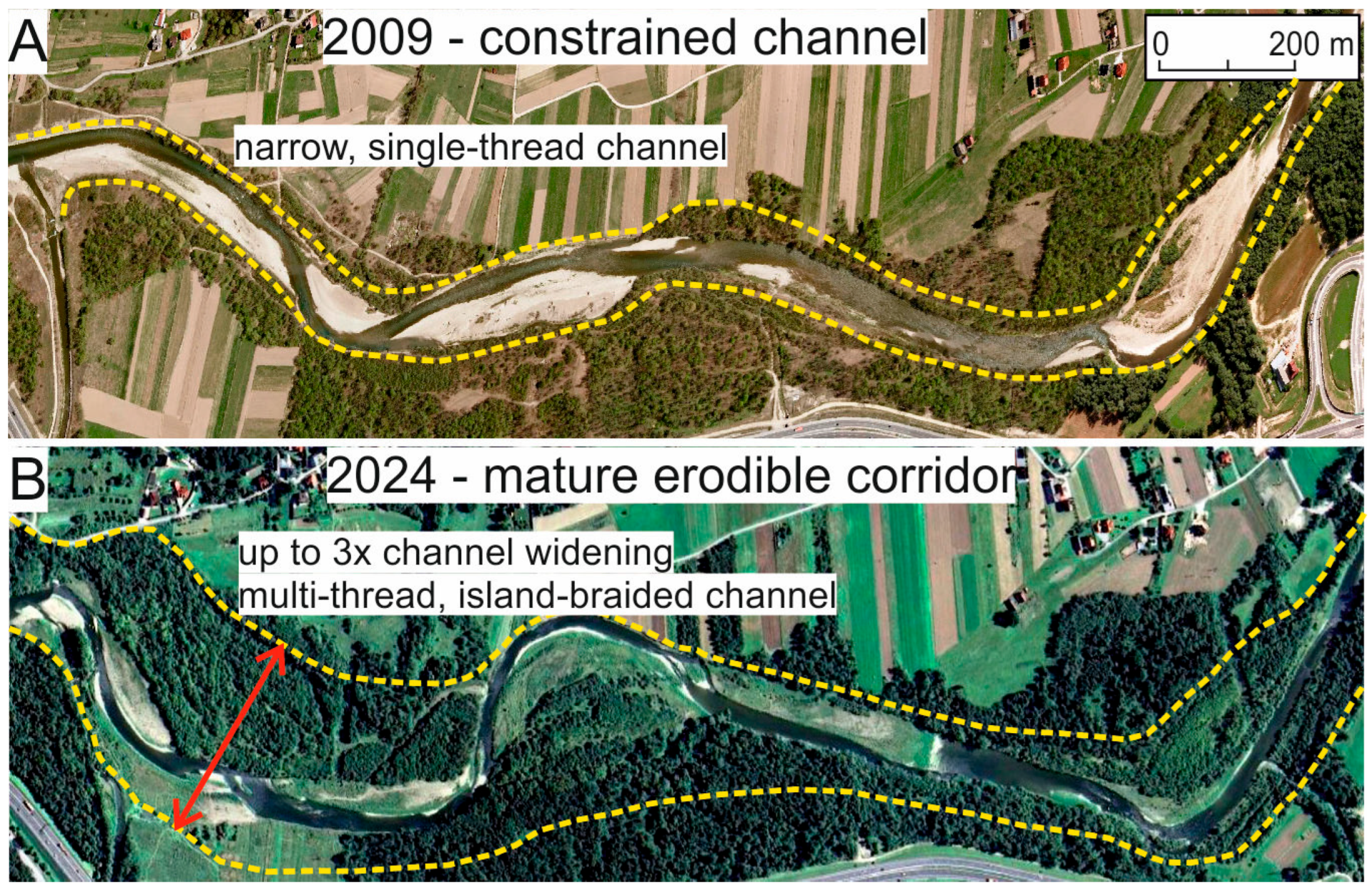
Erodible corridor is a well-known measurement which involves allowing the river to freely shape its channel along with bank erosion and gravel accumulation throughout the migration zone. The projects completed so far are ‘Oder border meanders’ on the Oder river (Figure 2, number 4); Biała Tarnowska river (Figure 2, number 19); and Raba river (Figure 2, number 4; Figure 4). Studies conducted on the Biała river confirmed that improving river hydromorphology (through an erodible corridor) is the appropriate restoration measure for degraded physical habitats [36].

3.1.2. Restoration of Multi-Thread Channel Pattern, with Bar-Braided or Island-Braided Morphology

It is considered as an effortless and effective way to improve the hydromorphological characteristics and physical habitat conditions of any gravel-bed river. In Poland, typical locations for these actions are erodible corridors or “Nature 2000” protected areas found in sections flowing within intermontane or foothill basins (Figure 2, numbers 11, 15). Studies on the Raba river conducted between 2011 and 2017 [37] can be a good example. Here, the abandonment of channelization structures along a 2.3 km reach within a forested corridor led to significant channel widening during floods with 30- and 35-year recurrence intervals in 2010 and 2014, followed by the re-establishment of a multi-thread channel pattern and the formation of islands. The study indicated that, in the early stages of island reestablishment in a mountain river recovering from channelization and channel incision, the contribution of islands to the overall species richness of the riparian corridor can vary greatly depending on hydraulic and hydrological conditions [37]. This contrasts with the situation in the vertically stable, multi-thread reach of the Czarny Dunajec river, where numerous well-established islands serve as an efficient source of propagules, and the presence of a relatively shallow channel facilitates their deposition on islands during floods [38].

3.1.3. Restoration of Large Woody Debris

Large wood is a common component of any natural river. Under natural conditions, LW is delivered to the river channel as a result of bank erosion. However, the proximity of human settlements modifies this process so that trees growing on the concave riverbanks are cut down in advance, thereby limiting LW delivery practically to major floods. The presence of LW serves many beneficial roles for both the river itself and its resident fauna. In recent years, it has begun to be used by water authorities and local communities in many Carpathian streams for the ad hoc protection against bank erosion near threatened development. The beneficial role of the large wood occurrence was studied on the Czarny Dunajec, Biała Tarnowska and Raba rivers (Figure 2, numbers 11, 15, 19).

3.1.4. Spontaneous River Renaturalization

The Czarny Dunajec river in Długopole (Figure 5A) underwent deepening and straightening in the 1970s, which increased its slope from 0.0054 m/m to 0.0081 m/m and lowered the riverbed by about 2.3 m. As shown in Figure 5D, the combined area of the three original braided channels was 69.6 m2, whereas the regulated channel expanded to 160.5 m2, 2.3 times larger. The new channel bed was lowered by 2.35 m relative to the average bed elevation of the former channels and by 1.99 m relative to their deepest points, causing a significant drop in water stages: minimum and mean annual stages fell by over 2.1 m, and the average maximum annual stage decreased by 1.95 m. Before channelization, maximum annual discharge flooded most of the island with the studied forest, but afterward, it remained 1 m below the surface. The minimum annual stage, previously less than 1 m below the island, dropped to 3 m below it after regulation. The river regulation works were carried out on a one-off basis and were not maintained later.
By 2020, forty years later, the channel width and slope at cross-section AB remained nearly unchanged from shortly after construction, while the median grain size of the bed material became much coarser, reflecting hydraulic adjustment. The channel developed low-flow threads and gravel bars up to 1.5 m above the deepest point, increasing bed roughness and raising the minimum annual stage by 0.35 m compared to immediately after regulation, though it remained 1.8 m lower than pre-regulation. The mean annual stage rose by 0.58 m yet was still 1.55 m below the pre-regulation level, and the stage at average maximum annual discharge increased by 0.67 m but remained 1.28 m lower than before, indicating both active channel adjustments and the formation of a new, low-lying floodplain. Some of the excavated material was leveled on the right bank to create new agricultural land, resulting in water-deprived soils unsuitable for cultivation, the destruction of the multi-channel riverbed system, and very impoverished riparian vegetation (Figure 5B). In contrast, a section of the river in Wróblówka, 2 km upstream and unaffected by regulatory works, maintained an exemplary island-braided channel pattern with consistent water availability for the riparian zone (Figure 5C). It can be treated as a model example of a natural gravel-bed Carpathian river.

3.2. Active Restoration Techniques

The vast majority of restoration actions carried out on the rivers of Southern Poland required active intervention in the riverbed or riparian zone and were mainly justified by the need to remove/unblock migration barriers for fish and by environmentally safe methods of erosion protection for the banks. This includes the following more important activities:

3.2.1. Check Dam/Concrete Weirs Lowering

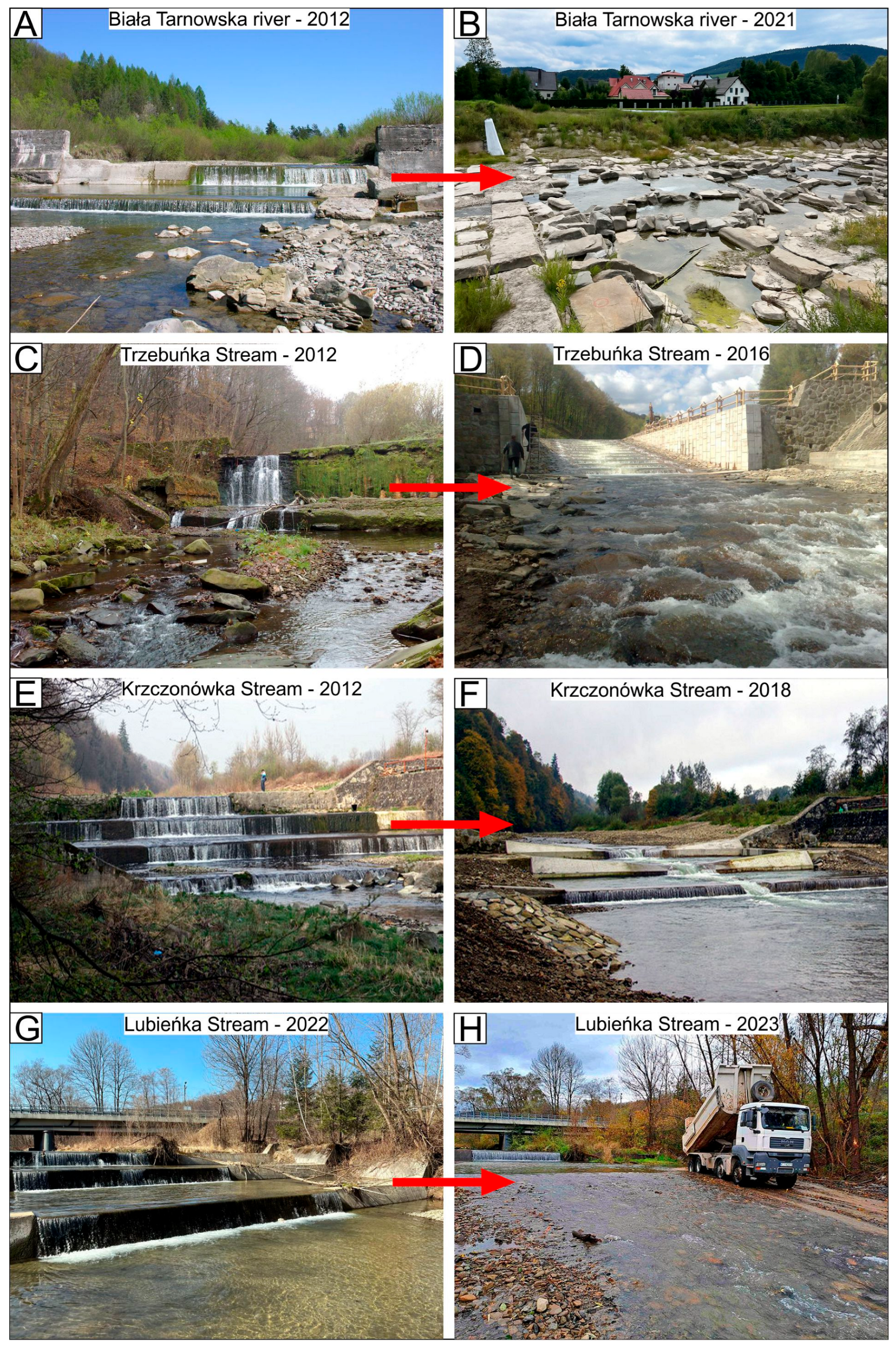
Neutralization of existing concrete dams was carried out as part of Polish–Swiss projects on two flysch streams, Krzczonówka and Trzebuńka (Figure 2, numbers 12, 13). In these cases, the high barriers were replaced with nature-like solutions in the form of pool-type fish passes. In the Krzczonówka Stream, a major flood occurred during the demolition of a concrete weir, which unexpectedly allowed for a rapid assessment of the project’s impact on river functioning. The project demonstrated that block ramps are effective at trapping bed material in an incised mountain stream. This restoration measure may be particularly useful for reducing excessive flow capacity in streams where there is no riparian forest or where the channel is wider than the height of riparian trees—conditions that prevent the natural formation of wood dams or the installation of constructed ones. A key factor in the success of this method is the availability of bed material that can be retained by the block ramps. In the Krzczonówka, such material was supplied from the reservoir of the lowered check dam, leading to rapid channel aggradation [39].
A significant increase in the taxonomic richness of benthic macroinvertebrates was inversely related to changes in bankfull channel depth at individual cross-sections. Although fish species richness and the abundance of subadult and adult individuals did not increase, the fish community structure shifted toward a more natural composition. Evaluations of restoration effects on ecological stream quality using the invertebrate-based BMWP-PL index and the European Fish Index produced contrasting results: the former indicated a marked improvement, while the latter showed no change in quality [40].
Restoration of the stream longitudinal continuity by neutralizing weirs and steps along the entire length of the river is currently taking place on the Kamienica Nawojowska and Sękówka streams (Figure 2, numbers 18, 22). It was also planned for the Kaczawa river (Figure 2, number 2), but no implementation plans have been made yet.

3.2.2. Construction of Fish Passes

Localized actions that did not remove obstacles but merely enabled relatively free fish migration were carried out on the Wisła, Skawa, Soła, Ropa, Wisłoka, and Jasiołka rivers (Figure 2, numbers 8–10, 23–24). Some of these are being monitored, providing a basis for evaluating their effectiveness. Fish passes are expensive and technically challenging hydraulic structures, and the decision to build them is usually taken only on large Polish rivers, where removing a dam or weir is not feasible. These installations address the issue of fish migration barriers to some extent, but the main problem—the interruption of sediment transport and the resulting sediment deficit—remains unresolved.

3.2.3. Reactivation of Blocked Braids/Side Channels

One example comes from the Czarny Dunajec river. After the 2010 flood, erosion of a bend in the main channel approached a local road by 50 m. Water authorities initially planned to cut a ditch through the forested neck of the bend, reinforce its banks, and block the main channel with a boulder groyne (estimated cost EUR ~60,000). Because this would have channelized a valuable multithread reach, degraded its ecological status, and increased downstream flood risk, an alternative solution was proposed. In 2011, inlets to inactive side braids near the bend were reopened (estimated cost EUR ~9000). Restoring flow in these steeper low-flow channels was expected to trigger cutoff and abandonment of the main channel during future floods. Gravel deflectors were built below the inlets to direct water into the side channels and limit flow into the main channel. Hydraulic measurements taken before and after implementation showed that the main current—with the highest velocity and bed shear stress—shifted from the braid closest to the road to the most distant one. Surveys of fish and benthic macroinvertebrates found increased abundance and taxonomic richness due to flow reactivation. The solution was not only less expensive but also improved ecological functions, enhanced habitat diversity, and maintained the reach’s role as a woody debris trap [13].

3.2.4. Artificial Riffles

Artificial riffles projected according to Thorne–Hey equilibrium equations [32] use rock–gravel material that simulates the natural bed of the stream. Their applicability in the rivers of Southern Poland is broad: vertical stabilization of deepened regulated channels; elimination of potholes and migration barriers on old, unmaintained concrete weirs; regulation of water levels for crop irrigation; creation of spawning grounds in rivers and streams lacking natural bed material; and prevention of sand and silt accumulation in channel structures in streams dominated by fine-grained material. So far, these methods have been mainly applied to the Bóbr, Tanew, and Ropa rivers, as well as the Sopot, Krzczonówka, Trzebuńka, and Lubieńka streams (Figure 2, numbers 1, 12–14, 18, 21, 22). They have also been designed for many subsequent locations, such as those seen in Figure 2, numbers 2, 17, and 27.
Figure 6 presents an example application of artificial riffles designed to mitigate the harmful impact of old concrete weirs on the Krzyworzeka Stream (Figure 2, number 17). With relatively little effort, exclusively within the framework of maintenance works, it is possible to restore the longitudinal continuity of the stream. An additional advantage is “river feeding” with much-needed and scarce rock–alluvial material in the form of a mixture from local gravel pits and quarries. Sediment replenishment is used not only in large rivers impounded by dams, where the downstream channel is sediment starved, but such measures are also undertaken locally in small mountain and upland streams that have either become excessively incised or contain bed material that is too fine—neither in dynamic equilibrium with current channel parameters nor suitable as spawning habitat for fish. A field example of successfully completed work using this technique is the filling of concrete thresholds on the Krzczonówka and Lubieńka streams with appropriately granulated and compacted gravel (Figure 7E–H).

3.2.5. Roughened Riffles and Honeycomb-Shape Riffles

These nature-like solutions were applied to eliminate concrete weirs that prevented fish migration by replacing them with the structures resembling high-gradient riffles with sediment sizes much coarser than those naturally occurring in the river. This applies to prevent erosion in high-energy mountain rivers where lateral channel migration during floods is unacceptable. During the restoration project carried out between 2017 and 2021 on the Biała Tarnowska river (with very large flow fluctuations, ranging up to 1000 times between the lowest and highest recorded flows; Figure 2, number 19), old concrete weirs were replaced with
  • Stone riffles of the “honeycomb” type (Figure 7A,B), consisting of interconnected pools of irregular shape. Their walls are built from large, heavy boulders and include gaps and overflow sections that allow for migration;
  • Cascade riffles, which, similarly to the structures mentioned above, are constructed from natural materials such as boulders and stone riprap. Their design consists of chambers separated by weir-like steps with gaps that enable migration;
  • A cascade of progressively lowered barriers reducing impoundment, involving partial lowering of the step structure and the provision of appropriate migration conditions through the construction of a series of barriers with slots allowing the passage of aquatic organisms.
  • Trzebuńka Stream, blocked by high check dam since 1935, was subjected to restoration within the project “The Upper Raba river spawning grounds” (Figure 7C,D). An 8 m-high dam was replaced with a 95 m-long structure, 65 m of which were built using so-called “grouted rock,” designed to resemble a natural rocky riverbed. The final design ensures full accessibility for people and all animal species, allowing unhindered migration along the stream. The structure can convey floodwaters and transport bedload, and its channel is dimensioned to accommodate very low, low, average, and high flows. During each of these flow conditions, the structure appears as though it were specifically designed for that state. It meets the requirements for stability, flood control, environmental compatibility, and enhanced amenity value.

3.2.6. Other Activities

Other measurements involved the local restoration of the river’s lateral continuity by reactivating oxbow lakes of the Vistula river (Figure 2, numbers 7A–C) and widening the river embankment, which also allowed for temporary valley water retention and increased its capacity. This group of measures also includes reducing the channel capacity of small watercourses, allowing them to overflow cyclically during discharges greater than Q10%, and—ideally—those exceeding Q50%. In protected areas, it is also important to maintain an appropriate species composition of riparian vegetation by restoring its natural character and removing invasive species. Local interventions are also being designed to reduce stream power by increasing channel sinuosity and recreating natural gravel-bed channels with suitable grain size.

4. Discussion

Despite extensive efforts to restore thousands of kilometers of impaired channels and substantial capital investments, river restoration has often fallen short of its goals. Many, if not most restoration projects have yet to deliver the anticipated hydrological, morphological, ecological, and societal benefits [41,42,43]. The problem does not lie in the poor quality of restoration activities, but in the subsequent fate of these river sections. Moreover, most restoration activities are point-based interventions conducted only within the riverbed, without considering the entire river corridor. It appears that effective improvement can be achieved by implementing the EN 14614:2020 standard, which is currently in use in Western Europe. Even costly measures such as the construction of fish passes on larger rivers do not lead to renaturalization in itself, as longitudinal channel continuity expressed in the transport of bed material, crucial in the context of preventing erosion in mountain rivers, remains disrupted or impossible. Undoubtedly, removing barriers in the riverbed is the first and most important method of restoration [44,45].
Incised channels by definition are typified by larger flow capacity and lower position of water stages associated with given discharges than vertically stable channels remaining in the state of geomorphic dynamic equilibrium [46]. It is well known that channel narrowing and straightening in the course of channelization leads to river incision [47] because, with reinforced channel banks, the resultant increase in river’s transport capacity cannot be compensated for by an increase in channel sinuosity and thus induces bed degradation [47]. However, in the Czarny Dunajec an incised channel was formed directly in the course of channelization works. The incised nature of the regulated channel was more apparent in >2 m lower position of water stages associated with minimum and mean annual discharges than in the pre-regulation channel and in the lack of inundation of channel banks during 40 years following the channelization.
Despite the implementation of numerous river restoration projects worldwide, the scarcity of monitored projects has resulted in limited scientific evidence of the changes in restored rivers. Wyżga et al. [46] believe that the right way to estimate the actual outcome of restoration project should be through the environmental monitoring conducted during the initial and final phases of a given project, as well as five years after its completion. Currently, such a comparison is being developed for completed restoration projects on the Raba and Biała Tarnowska rivers (erodible corridor). Preliminary results indicate a lasting improvement in hydromorphological conditions in both catchments. A more complex issue is the reliable assessment of temperature and water quality-sensitive fish and benthic macroinvertebrates, as several measurements have shown that even short-term pollution from ubiquitous sewage discharges in mountain rivers eliminates many (often most) of the typically occurring species.
On the other hand, it is already known that many restoration measures in the rivers of Southern Poland have demonstrated durability and improvement in river conditions. Studies conducted between 2010 and 2012 on the Czarny Dunajec river [37] and the Raba river [38] showed significantly better abiotic and biotic parameters in river corridors enriched with river islands compared to narrow, single-thread sections of these rivers. Separating the river’s flow by reactivating side channels not only mitigated the erosion risk for a local road but also significantly increased the biodiversity of the Czarny Dunajec river [13].
Promising results have been observed in rivers and streams restored with the use of artificial riffles. Those constructed on the Bóbr river in 2013–2014 [48] have proven to be durable forms even after nine years, including the highest observed flood. Their longevity depends on the meticulous execution relative to the design, and when done properly, they serve not only to prevent erosion but also as spawning grounds. Exemplary implementations of artificial riffles can be seen in the Krzczonówka, Trzebuńka, and Lubieńka streams. Environmental monitoring conducted for the first of these streams demonstrated the positive impact of these structures on both physical [39] and biotic parameters [40]. Many important findings regarding potential projects for the river have not yet been published but are currently being processed and discussed.
Effective restoration activities should begin with identifying reference conditions, which are unique to each river and require thorough hydromorphological and biological analyses [49]. However, the exact methods for identifying these conditions are not fully understood [5]. Efforts are being made to envision the river’s conditions before human impact, e.g., Refs. [8,50], as there is no single effective “recipe” for river restoration [51]. Another problem is ensuring sufficient funding for restoration projects, as it has been calculated that the average cost of restoring 1 ha of a European river is EUR 310,000 [52]. The modern approach also suggests biomic river restoration [53]. Disrupting the equilibrium of a river system is long-lasting and difficult to reverse. The last major example was the “Oder River Disaster” that occurred in summer 2022, when a massive fish die-off was observed along the Oder river in Poland and Germany. The catastrophe was caused by a combination of factors—primarily industrial pollution that led to a toxic algal bloom (of the golden algae Prymnesium parvum), triggered by high salinity and low water levels during a heatwave. However, we have an impact on the future: leaving “room for the river” is the most fruitful compromise between the goals of WFD and environmental objectives concerning the preservation of the quality and condition of the river along with its surroundings.
To summarize, a number of questions and uncertainties regarding the restoration actions arise:
  • What are we actually trying to achieve? Any project considered as river restoration must be sufficiently comprehensive to take into account the river’s real needs and to correctly assess its condition [54]. Each stakeholder has different expectations of the river: a scientist wants it to display good indicators of hydromorphological parameters and physical habitat conditions; an angler wants it to be rich in valuable fish species; local residents prioritize flood safety and the prevention of water spilling onto private land above all else; local water authorities face a lack of funding for comprehensive river management and must balance their actions to satisfy the interests of the above groups. As a result, many activities carried out under the banner of river maintenance are in practice minor regulatory works that do nothing to improve the state of the river.
  • How successful are projects? Many restoration projects have demonstrated that even technically advanced interventions may yield only partial or short-lived ecological benefits. The large-scale restoration of the Skjern river (Denmark) successfully re-meandered the channel and reconnected former floodplains, yet post-implementation monitoring revealed that habitat diversity and ecological functions did not fully recover as anticipated due to altered hydromorphological processes and landscape constraints [55]. A similar pattern is evident in the Kissimmee river (Florida), where re-establishing a more natural channel layout partly improved wetland conditions and fish communities, but long-term hydrological management challenges and incremental implementation hindered full ecological recovery [56]. The removal of dams on the Elwha river in Washington State led to an eventual resurgence of migratory fish populations, yet in the short and medium term the sudden release of stored sediments caused major disturbances to channel structure and aquatic habitats, illustrating the complexity of translating physical reconnection into immediate ecological success [57]. Numerous case studies across European rivers, such as on the Horloff in Germany, further show that fragmented planning, insufficient catchment-scale coordination, and competing land-use pressures frequently limit restoration outcomes [58]. Broader reviews emphasize that many efforts are still evaluated too early or without long-term, process-based monitoring, leading to an overestimation of success and underestimation of underlying hydromorphological constraints [59].
  • Uncertainty in the future development of the river channel. The mechanisms of fluvial processes in gravel-bed rivers allow them to shape their channels freely, even if they have been subject to regulatory works. This is a key reason why a river should have a suitably wide floodplain. For example, after the reactivation of blocked braids in the Czarny Dunajec river (see Section 3.2.3), the threat of erosion to a local road was permanently eliminated at that site. However, after the main active channel avulsed upstream of the study site during the May 2014 flood, bank erosion at another location began to threaten the nearby road. This suggests that, given the highly unstable flow regime in the multi-thread reach, a more effective management strategy may be to avoid interventions within the active river zone and instead reinforce channel banks locally where migrating channels approach valley-floor infrastructure.
  • What does river restoration actually provide for the river and for people? Every responsible project implementer expects their actions to be effective and durable over many years. We hope that a restored river is not only natural but also visually appealing, safe, and a local asset. However, even when a large, comprehensive, and well-designed restoration project is carried out, we cannot be certain of the long-term durability of its outcomes. This is why long-term monitoring of restoration projects is particularly important in order to assess their real impact on improving river conditions. Research of this kind is currently being conducted on Carpathian watercourses and will be published upon completion. Sometimes, maintaining a river in good condition only requires the effective observance and enforcement of existing legislation. Many residents of riparian areas treat them as their private property, placing their own intentions above the law.
  • Additional risks not previously considered. As our understanding of river systems develops, we are discovering further threats that were not previously assessed and are linked to freeing rivers from regulatory structures. Among these risks, particular attention should be paid to (i) secondary pollution of the river with heavy metals and other chemicals resulting from the erosion and redeposition of previously stabilized, regulated banks [19,20] and (ii) increased retention of macroplastics, especially in connection with woody debris in wide multi-thread river sections. Plastic subjected to mechanical abrasion in the water flow, cyclical UV exposure, and biochemical erosion becomes a source of secondary microplastics, which, moving freely through the ecosystem, enter living organisms [15,16].

5. Conclusions

This study demonstrates that renaturalization, particularly when implemented at the scale of the river corridor, can effectively reverse hydromorphological degradation in gravel-bed streams of Southern Poland. Both passive and active restoration techniques contributed to improving channel morphology, restoring longitudinal continuity, and enhancing conditions for aquatic and riparian biota. Passive approaches, though less frequently applied, provided substantial long-term benefits by allowing rivers to regain dynamic processes such as channel migration and island formation. Active interventions, including fish passes, lowering of check dams, and construction of artificial riffles, which supported sediment transport and habitat diversification where spontaneous recovery alone was insufficient. The case study from the Czarny Dunajec river highlights that rivers can partially self-restore when given space to adjust but also underscores the long recovery periods required after severe channel incision. Importantly, successful restoration requires interdisciplinary cooperation among scientists, water authorities, and local communities, as well as careful planning based on reference conditions. The persistence of macroplastic accumulation and the potential release of pollutants from eroding regulated banks represent emerging challenges that should be incorporated into future project designs. Long-term monitoring remains essential to evaluate project outcomes, understand ecological trajectories, and guide adaptive management. Overall, restoring degraded Carpathian streams provides ecological, hydrological, and social benefits but requires sustained commitment to maintaining natural river processes and preventing further anthropogenic pressures.

Funding

This study was prepared within the scope of Research Project 2023/51/D/ST10/01816 financed by the National Science Centre of Poland.

Data Availability Statement

The original contributions presented in this study are included in the article. Further inquiries can be directed to the corresponding author.

Acknowledgments

I would like to thank Józef Jeleński and two anonymous reviewers for their valuable comments during writing of this paper.

Conflicts of Interest

The author declares no conflicts of interest.

References

  1. Sawyer, A.H.; Cardenas, M.B.; Bomar, A.; Mackey, M. Impact of dam operations on hyporheic exchange in the riparian zone of a regulated river. Hydrol. Process. 2009, 23, 2129–2137. [Google Scholar] [CrossRef]
  2. Kondolf, G.M.; Boulton, A.J.; O’Daniel, S.; Poole, G.C.; Rahel, F.J.; Stanley, E.H.; Wohl, E.; Bång, A.; Carlstrom, J.; Cristoni, C.; et al. Process-Based Ecological River Restoration: Visualizing Three-Dimensional Connectivity and Dynamic Vectors to Recover Lost Linkages. Ecol. Soc. 2006, 11, 5. [Google Scholar] [CrossRef]
  3. Bennett, S.; Simon, J.; Castro, J.; Atkinson, C.; Bronner, S.; Rabideau, A. The evolving science of stream restoration. In Stream Restoration in Dynamic Fluvial Systems: Scientific Approaches, Analyses, and Tools; Geophysical Monograph Series; Simon, A., Bennett, S., Castro, J., Eds.; AGU: Washington, DC, USA, 2007; Volume 194, pp. 1–8. [Google Scholar] [CrossRef]
  4. Wohl, E.; Angermeier, P.L.; Bledsoe, B.; Kondolf, G.M.; MacDonnell, L.; Merritt, D.M.; Palmer, M.A.; Poff, N.L.; Tarboton, D. River restoration. Water Resour. Res. 2005, 41, W10301. [Google Scholar] [CrossRef]
  5. Wohl, E.; Lane, S.N.; Wilcox, A.C. The science and practice of river restoration. Water Resour. Res. 2015, 51, W10301. [Google Scholar] [CrossRef]
  6. RiverViki Map Powered by River Restoration Centre (UK). Available online: https://www.restorerivers.eu/wiki/index.php? (accessed on 15 October 2025).
  7. Szafraniec, B. Ujarzmianie Odry: Regulacja Rzeki w XIX Wieku w Obrębie Rejencji Opolskiej; Muzeum Śląska Opolskiego: Opole, Poland, 2014. [Google Scholar]
  8. Wyżga, B.; Zawiejska, J.; Radecki-Pawlik, A.; Hajdukiewicz, H. Environmental change, hydromorphological reference conditions and the restoration of Polish Carpathian rivers. Earth Surf. Process. Landf. 2012, 37, 1213–1226. [Google Scholar] [CrossRef]
  9. Gorczyca, E. Rozwój Górskich Żwirodennych Koryt Rzecznych w Warunkach Antropopresji; Wydawnictwo IGiGP UJ: Kraków, Poland, 2016. [Google Scholar]
  10. Hajdukiewicz, H.; Wyżga, B.; Amirowicz, A.; Oglęcki, P.; Radecki-Pawlik, A.; Zawiejska, J.; Mikuś, P. Ecological state of a mountain river before and after a large flood: Implications for river status assessment. Sci. Total Environ. 2018, 610–611, 244–257. [Google Scholar] [CrossRef]
  11. Wyżga, B. A review on channel incision in the Polish Carpathian rivers during the 20th century. Dev. Earth Surf. Process. 2007, 11, 525–553. [Google Scholar] [CrossRef]
  12. Stanford, J.A.; Ward, J.V.; Liss, W.J.; Frissell, C.A.; Williams, R.N.; Lichatowich, J.A.; Coutant, C.C. A general protocol for restoration of regulated rivers. Regul. Rivers Res. Manag. 1996, 12, 391–413. [Google Scholar] [CrossRef]
  13. Mikuś, P.; Wyżga, B.; Radecki-Pawlik, A.; Zawiejska, J.; Amirowicz, A.; Oglęcki, P. Environment-friendly reduction of flood risk and infrastructure damage in a mountain river: Case study of the Czarny Dunajec. Geomorphology 2016, 272, 43–54. [Google Scholar] [CrossRef]
  14. Gallitelli, L.; Scalici, M. Riverine macroplastic gradient along watercourses: A global overview. Front. Environ. Sci. 2022, 10, 937944. [Google Scholar] [CrossRef]
  15. Liro, M.; Mikuś, P.; Wyzga, B. First insight into the macroplastic storage in a mountain river: The role of in-river vegetation cover, wood jams and channel morphology. Sci. Total Environ. 2022, 838, 156354. [Google Scholar] [CrossRef] [PubMed]
  16. Liro, M.; van Emmerik, T.H.M.; Zielonka, A.; Gallitelli, L.; Mihai, F.C. The unknown fate of macroplastic in mountain rivers. Sci. Total Environ. 2023, 865, 161224. [Google Scholar] [CrossRef]
  17. Viviroli, D.; Dürr, H.H.; Messerli, B.; Meybeck, M.; Weingartner, R. Mountains of the world, water towers for humanity: Typology mapping, and global significance. Water Resour. Res. 2007, 43, 7. [Google Scholar] [CrossRef]
  18. Margenat, H.; Ruiz-Orejón, L.F.; Cornejo, D.; Martí, E.; Vila, A.; Le Roux, G.; Hansson, S.; Guasch, H. Guidelines of Field-Tested Procedures and Methods for Monitoring Plastic Litter in Mountain Riverine Systems (PLASTICØPYR Project); European Commission: Luxembourg, 2021. [Google Scholar]
  19. Khosrovyan, A. The Ecological Effects of Micro(nano)plastics in the Water Environment. Water 2024, 16, 2020. [Google Scholar] [CrossRef]
  20. Khosrovyan, A. Biodiversity and Ecosystem Services in Rivers. Water 2024, 16, 2091. [Google Scholar] [CrossRef]
  21. Riba, I.; Gabrielyan, B.; Khosrovyan, A.; Luque, A.; Del Valls, T.A. The influence of ph and waterborne metals on egg fertilization of the blue mussel (Mytilus edulis), the oyster (Crassostrea gigas) and the sea urchin (Paracentrotus lividus). Environ. Sci. Pollut. Res. 2016, 23, 14580–14588. [Google Scholar] [CrossRef]
  22. WWF Poland. Krajowy Program Renaturyzacji Wód Powierzchniowych (National Programme for Surface Water Restoration). WWF Polska, 2023. Available online: https://www.wwf.pl/krajowy-program-renaturyzacji-wod (accessed on 9 November 2025).
  23. Supreme Audit Office (Najwyższa Izba Kontroli, NIK). Stan wód w Polsce. NIK, 2025. Available online: https://www.nik.gov.pl/najnowsze-informacje-o-wynikach-kontroli/stan-wod-w-polsce-2025.html (accessed on 9 November 2025).
  24. Morandi, B.; Cottet, M.; Piégay, H. River Restoration: Political, Social, and Economic Perspectives; Wiley-Blackwell: Hoboken, NJ, USA, 2021. [Google Scholar]
  25. Lüderitz, V.; Jüpner, R.; Müller, D.; Feld, C.K. Renaturalization of streams and rivers—The special importance of integrated ecological methods in measurement of success. An example from Saxony-Anhalt (Germany). Limnologica 2004, 34, 249–263. [Google Scholar] [CrossRef]
  26. Kuhlmann, F.; Balicka, J.; Wilczyńska, A. Urban river revitalisation. In Urban Blue Spaces Planning and Design for Water, Health and Well-Being; Bell, S., Fleming, L.E., Grellier, J., Kuhlmann, F., Nieuwenhuijsen, M.J., White, M.P., Eds.; Routledge: London, UK, 2021; pp. 239–287. [Google Scholar]
  27. Environmental Protection Agency. Available online: https://www.epa.gov/healthresearch/remediation-restoration-revitalization (accessed on 15 October 2025).
  28. PN-EN 14614:2020; Jakość wody—Wytyczne do oceny hydromorfologicznych cech rzek. Polski Komitet Normalizacyjny: Warszawa, Poland, 2020.
  29. Gurnell, A.M.; Grabowski, R.C. An Example Application of the CEN Water Quality—Guidance Standard for Assessing the Hydromorphological Features of Rivers to the River Frome, Dorset, Southern England; UK Centre for Ecology and Hydrology: Wallingford, UK, 2020. [Google Scholar]
  30. Gurnell, A.M.; Rinaldi, M.; Belletti, B.; Bizzi, S.; Blamauer, B.; Braca, G.; Buijse, A.D.; Bussettini, M.; Camenen, B.; Comiti, F.; et al. A multi-scale hierarchical framework for developing understanding of river behaviour to support river management. Aquat. Sci. 2016, 78, 1–16. [Google Scholar] [CrossRef]
  31. Rosgen, D.L. A classification of natural rivers. Catena 1994, 22, 169–199. [Google Scholar] [CrossRef]
  32. Thorne, C.R.; Hey, R.D.; Newson, M.D. Applied Fluvial Geomorphology for River Engineering and Management; Wiley: Chichester, UK, 1997. [Google Scholar]
  33. Jeleński, J. Przykłady wykorzystania równań Hey’a-Thorne’a do oceny stanu koryt rzek górskich i planowania robót utrzymaniowych. In Problemy Planowania w Gospodarce Wodnej i Oceny Stanu Hydromorfologicznego Rzek; Walczykiewicz, T., Ed.; Wydawnictwo IMGW-PIB: Warszawa, Poland, 2016; pp. 227–252. [Google Scholar]
  34. Jeleński, J.; Wyżga, B. Możliwe Techniczne i Biologiczne Interwencje w Utrzymaniu Rzek Górskich; Stowarzyszenie “Ab Ovo”: Kraków, Poland, 2016. [Google Scholar]
  35. Krakowskie Przedsiębiorstwo Budownictwa Wodno-Inżynieryjnego (KPBWI). Roboty Regulacyjne na Potoku Czarny Dunajec w Długopolu; KPBWI: Kraków, Poland, 1974. [Google Scholar]
  36. Wyżga, B.; Oglęcki, P.; Hajdukiewicz, H.; Zawiejska, J.; Radecki-Pawlik, A.; Skalski, T.; Mikuś, P. Interpretation of the invertebrate-based BMWP-PL index in a gravel-bed river: Insight from the Polish Carpathians. Hydrobiologia 2013, 712, 71–88. [Google Scholar] [CrossRef]
  37. Mikuś, P.; Wyżga, B.; Kaczka, R.J.; Walusiak, E.; Zawiejska, J. Islands in a European mountain river: Linkages with large wood deposition, flood flows and plant diversity. Geomorphology 2013, 202, 115–127. [Google Scholar] [CrossRef]
  38. Mikuś, P.; Wyżga, B.; Walusiak, E.; Radecki-Pawlik, A.; Liro, M.; Hajdukiewicz, H.; Zawiejska, J. Island development in a mountain river subjected to passive restoration: The Raba River, Polish Carpathians. Sci. Total Environ. 2019, 660, 406–420. [Google Scholar] [CrossRef]
  39. Wyżga, B.; Liro, M.; Mikuś, P.; Zawiejska, J.; Plesiński, K.; Jeleński, J.; Radecki-Pawlik, A. Changes of fluvial processes caused by the restoration of an incised mountain stream. Ecol. Eng. 2021, 168, 106286. [Google Scholar] [CrossRef]
  40. Mikuś, P.; Wyżga, B.; Bylak, A.; Kukuła, K.; Liro, M.; Oglęcki, P.; Radecki-Pawlik, A. Impact of the restoration of an incised mountain stream on habitats, aquatic fauna and ecological stream quality. Ecol. Eng. 2021, 170, 106365. [Google Scholar] [CrossRef]
  41. Geist, J.; Hawkins, S. Habitat recovery and restoration in aquatic ecosystems: Current progress and future challenges. Aquat. Conserv. Mar. Freshw. Ecosyst. 2016, 26, 942–962. [Google Scholar] [CrossRef]
  42. Haase, P.; Hering, D.; Jähnig, S.C.; Lorenz, A.W.; Sundermann, A. The impact of hydromorphological restoration on river ecological status: A comparison of fish, benthic invertebrates, and macrophytes. Hydrobiologia 2013, 704, 475–488. [Google Scholar] [CrossRef]
  43. Palmer, M.A.; Menninger, H.L.; Bernhardt, E. River restoration, habitat heterogeneity and biodiversity: A failure of theory or practice? Freshw. Biol. 2010, 55, 205–222. [Google Scholar] [CrossRef]
  44. Parasiewicz, P.; Belka, K.; Łapińska, M.; Ławniczak, K.; Prus, P.; Adamczyk, M.; Buras, P.; Szlakowski, J.; Kaczkowski, Z.; Krauze, K.; et al. Over 200,000 kilometers of free-flowing river habitat in Europe is altered due to impoundments. Nat. Commun. 2023, 14, 6289. [Google Scholar] [CrossRef]
  45. Garcia de Leaniz, C.; Wantzen, K.M.; Wolter, C.; Tharme, R.E.; Zalewski, M.; Belletti, B. Editorial: Challenges and benefits of restoring river connectivity. Front. Ecol. Evol. 2020, 11, 1110413. [Google Scholar] [CrossRef]
  46. Wyżga, B.; Amirowicz, A.; Bednarska, A.; Bylak, A.; Hajdukiewicz, H.; Kędzior, R.; Kukuła, K.; Liro, M.; Mikuś, P.; Oglęcki, P.; et al. Scientific monitoring of immediate and long-term effects of river restoration projects in the Polish Carpathians. Ecohydrol. Hydrobiol. 2021, 21, 244–255. [Google Scholar] [CrossRef]
  47. Wyżga, B.; Zawiejska, J.; Radecki-Pawlik, A. Impact of channel incision on the hydraulics of flood flows: Examples from Polish Carpathian rivers. Geomorphology 2016, 272, 10–20. [Google Scholar] [CrossRef]
  48. Jeleński, J.; Mikuś, P. Zastosowanie przyjaznego środowisku podejścia inżynierskiego do ograniczania ryzyka powodzi na przykładzie regulacji odcinka rzeki Bóbr w Wojanowie. Gospod. Wodna 2016, 4, 101–109. [Google Scholar]
  49. Urbanič, G.; Mihaljević, Z.; Petkovska, V.; Urbanič, P.M. Back to Ecology: Reference Conditions as a Basis for Assessment, Restoration and Sustainable Management of Large Rivers. Water 2021, 13, 2596. [Google Scholar] [CrossRef]
  50. Wiejaczka, Ł.; Kijowska-Strugała, M. Hydromorphological state of Carpathian rivers. Water Environ. J. 2015, 29, 277–287. [Google Scholar] [CrossRef]
  51. Nestler, J.C.; Lubinski, K.; Smith, D. Reference condition approach to restoration planning. River Res. Appl. 2010, 26, 1199–1219. [Google Scholar] [CrossRef]
  52. Szałkiewicz, E.; Jusik, S.; Grygoruk, M. Status of and perspectives on river restoration in Europe: 310,000 Euros per hectare of restored river. Sustainability 2018, 10, 129. [Google Scholar] [CrossRef]
  53. Johnson, M.F.; Thorne, C.R.; Castro, J.M.; Kondolf, G.M.; Mazzacano, C.S.; Rood, S.B.; Westbrook, C. Biomic river restoration: A new focus for river management. River Res. Appl. 2020, 36, 3–12. [Google Scholar] [CrossRef]
  54. Belletti, B.; Garcia de Leaniz, C.; Jones, J.; Bizzi, S.; Börger, L.; Segura, G.; Castelletti, A.; Van de Bund, W.; Aarestrup, K.; Barry, J.; et al. More than one million barriers fragment Europe’s rivers. Nature 2020, 588, 436–441. [Google Scholar] [CrossRef]
  55. Kristensen, E.A.; Kronvang, B.; Wiberg-Larsen, P.; Thodsen, H.; Nielsen, C.; Amor, E.; Friberg, N.; Pedersen, M.L.; Baattrup-Pedersen, A. 10 years after the largest river restoration project in Northern Europe: Hydromorphological changes on multiple scales in River Skjern. Ecol. Eng. 2014, 66, 141–149. [Google Scholar] [CrossRef]
  56. Whalen, P.J.; Toth, L.A.; Koebel, J.W.; Kissimmee, P.K. River restoration: A case study. Water Sci. Technol. 2002, 45, 55–620. [Google Scholar] [CrossRef]
  57. Bednarek, A. Undamming Rivers: A Review of the Ecological Impacts of Dam Removal. Environ. Manag. 2001, 27, 803–814. [Google Scholar] [CrossRef] [PubMed]
  58. Schürings, C.; Kaijser, W.; Gillmann, S.M.; Kiesel, J.; Nguyen, H.H.; Peters, K.; Rolauffs, P.; Haase, P.; Lorenz, A.W.; Hering, D. Drivers of recovery and degradation of riverine benthic invertebrate communities: A Germany-wide analysis. Ecol. Process. 2025, 14, 30. [Google Scholar] [CrossRef]
  59. Bernhardt, E.; Palmer, M. Evaluating River Restoration. Ecol. Appl. 2011, 21, 1925. [Google Scholar] [CrossRef]
Figure 1. Effects of rapid channel incision of rivers in Southern Poland illustrated on the Czarny Dunajec river (A) and Krzyworzeka Stream (B).
Water 17 03315 g001
Figure 2. The location of major restoration actions undertaken on the rivers of Southern Poland. Materials available on the following website have been partially used: https://renaturyzacja.imgw.pl/mapa/ (accessed on 5 November 2025).
Water 17 03315 g002
Figure 3. Schematic sketch of the riffle-pool sequence with a cross-section through the typical artificial riffle used in gravel-bed rivers in Southern Poland.
Water 17 03315 g003
Figure 4. Selected geomorphological changes betweenbefore establishing the erodible corridor (A) and inside a mature erodible corridor of the Raba river (B).
Water 17 03315 g004
Figure 5. Effects of artificial channel deepening and spontaneous channel restoration in the section of the Czarny Dunajec river experienced by regulation works. (A)—Location of the compared river sections on the orthophoto; (B)—view and cross-section through the natural, island-braided reach; (C)—view and cross-section through the artificially deepened reach; (D)—self-restoration mechanism in the artificially deepened reach.
Water 17 03315 g005
Figure 6. Application of artificial riffles designed to mitigate the harmful impact of old concrete weirs on the Krzyworzeka Stream.
Water 17 03315 g006
Figure 7. Concrete weir on the Biała Tarnowska river (A) rebuilt into a “honeycomb” type riffle (B); reconstruction of a high check dam on Trzebuńka Stream (C) into a long-roughened riffle serving also as a fish pass (D); and filling of old weirs on the Krzczonówka (E,F) and Lubieńka (G,H) streams with a gravel.
Water 17 03315 g007
Table 1. Selected restoration measures undertaken on gravel-bed watercourses in Southern Poland. Basic hydrological characteristics were presented for the section of the interventions carried out, not on average for the entire river. Floodplain width was assumed as an extent of the 100-year flood.
Number (Figure 2)River/StreamCatchment Area [km2]Mean Annual FlowMain Channel Width [m]Floodplain Width [m]Type of
Measurement
Scope of WorksImplementation StatusRestored Stream Length [km]
1Bóbr R.5356.05.0220RevitalizationArtificial rifflesCompleted (2014–2015)6
2Kaczawa R.17998.418760RevitalizationNeutralizing of weirs and stepsProject prepared, no implementation58
3Odra R.19,6843001101270RevitalizationImproving sewage managementApproved in the form of a government act (2023)entire river course
4Odra R.46594248580RenaturalizationErodible corridorCompleted (2004)7
5Odra R.78006553670RenaturalizationWidening the river embankmentCompleted (2015)5
6Czechowicki S.8.40.123.338RevitalizationNatural flood protectionCompleted (2020)4
7 A–CVistula R.17743521480RevitalizationRestoring 3 oxbow lakesCompleted (2016)3
8 A–BSoła R.13581523370RevitalizationFish passCompleted (2023)0.1
9 A–BVistula R.25504724550RevitalizationFish passCompleted (2023)0.1
10 A–CSkawa R.4668.225473RevitalizationFish passCompleted (2023)0.1
11Raba R.64410.718425RenaturalizationErodible corridor + Restoration of the stream longitudinal continuityCompleted (2010)3.5
12Trzebuńka S.60.3635RevitalizationRestoration of the stream longitudinal continuityCompleted (2016)6
13Krzczonówka S.881.51284RenaturalizationRestoration of the stream longitudinal continuityCompleted (2016)2
14Lubieńka S.470.6721RevitalizationRestoration of the stream longitudinal continuityCompleted (2023)0.3
15Czarny Dunajec R.2004.323440RevitalizationProving the relevance of wooded islands in multi-thread riversCompleted (2011)3.5
16Czarny Dunajec R.2204.422450RevitalizationReactivation of blocked braidsCompleted (2013)0.5
17Krzyworzeka S.771.21530Renaturalizationfloodplain widening + artificial rifflesPlanned entire stream course
18Kamienica Nawojowska R.641.11265RevitalizationNeutralizing of weirs and stepsIn progress (2023- present)12
19Biała Tarnowska R.2062.820200RenaturalizationErodible corridor + Restoration of the stream longitudinal continuityCompleted (2014)20.4
20Biała Tarnowska R.5235.828440RevitalizationNeutralizing of weirs and stepsCompleted (2020)entire river course
21Ropa R.4844.431480RevitalizationFish passes/artificial rifflesCompleted (2020)entire river course
22Sękówka S.1221.913210RevitalizationLowering of the barrageIn progress (2024-present)0.1
23A-CWisłoka R.255028541090RevitalizationFish passesCompleted (2020)entire river course
24Jasiołka S.512619260RevitalizationFish passesCompleted (2020)entire stream course
25Tanew R.7253.51873RevitalizationArtificial riffles, river feedingCompleted (2022)0.5
26Sopot S.850.151248RevitalizationArtificial rifflesCompleted (2021)0.3
27Niepryszka S.30.50.155.526RenaturalizationArtificial rifflesPlannedentire stream course
Disclaimer/Publisher’s Note: The statements, opinions and data contained in all publications are solely those of the individual author(s) and contributor(s) and not of MDPI and/or the editor(s). MDPI and/or the editor(s) disclaim responsibility for any injury to people or property resulting from any ideas, methods, instructions or products referred to in the content.