Abstract
Numerical simulation models are very useful for assessing groundwater flow and levels in a given region. With the scarcity of available groundwater resources after the 2000s, the city of Beijing adopted policies for the rehabilitation of these resources. This study establishes a numerical simulation model that evaluates the influence of these projects on groundwater levels over a given period. To achieve this, an unstructured model was established for the Beijing Plain region and run using GMS 10.6 software with a finer mesh around reservoirs, water stations, major rivers and flow boundaries. The calibration and the identification results indicated a correlation R2 = 0.98 between calculated and observed heads. The model’s accuracy is good and the overall average relative error is less than 20%. The comparison of the calculated water balance with the results of numerous studies shows that the reliability of the equilibrium analysis result is relatively high. The groundwater numerical model is running to simulate the water level over a period of 15 years. Groundwater generally flows in a northwest/southeast direction. The simulation results also demonstrate the impact of some projects related to the South-to-North Water Transfer Project implemented for the restoration of overexploited groundwater resources. The model predicts a stabilized and significantly increasing groundwater level at the center of the Beijing area.
1. Introduction
Numerical simulation of groundwater in foreign countries started in the 1960s. It has been developed rapidly with the improvement of computer performance, user interface systems, the reliability and accessibility of a large amount of data especially in groundwater and other related areas of concern [1,2]. For various reasons, Chinese groundwater numerical simulation research started in the 1970s. Groundwater simulation methods have evolved considerably, ranging from simple flow models to more complex solute transport models [3]. Groundwater numerical models are applied for forecasting and management [4,5,6] and the research scope involves a saturated zone, an unsaturated zone and a saturated–unsaturated zone. So far, groundwater numerical modeling has become an important tool for quantitatively evaluating groundwater resources and analyzing groundwater environmental changes.
The method of simulating groundwater flow and solute transport problems using numerical models has gradually become an important method in the field of groundwater research with its effectiveness and flexibility and has been widely used [7,8,9]. MODFLOW USG (Unstructured Grid Method of Modular finite-difference flow model) is a new version of the MODFLOW groundwater simulation program that can be run from the command line or built into the GMS software. It provides a more flexible and efficient unstructured grid dissection which is effective in dealing with complex, irregular and non-homogeneous geologic bodies with complex boundaries. Unlike the traditional MODFLOW model which uses structured linear grids, unstructured grids can be used in a variety of ways including nested grids, triangles, rectangles or other polygons including triangles, rectangles, or other polygon-shaped geometries to accurately discretize the study domain. This accurate discretization can effectively improve the model’s resolution in the area of interest [10]. In 1976, Narasimhan et al. [11] proposed the integral-limited-difference method for solving groundwater flow problems in porous media, the theory of the finite difference method, which laid the foundation for MODFLOW USG on unstructured grids. In 2014, David Krcmar et al. [12] introduced the new MODFLOW USG, which is a great tool for complicated conditions, with many improvements over the classical structured grid approach. The model can deal with many complicated features, such as discontinuities (geological faults, mine openings, etc.), steep and uneven slopes or the pinching out of layers. In 2018, Ezzeldin et al. [13] presented the results of MODFLOW USG vs. the MODFLOW 2005 traditionally structured version in simulating Quaternary multilayered groundwater in the East Nile Delta, Egypt. The results show that the MODFLOW USG grid design is more flexible, can use many non-rectangular-shaped grid cells and have a shorter time of running. In 2020, Cui et al. [14] studied groundwater recharge by a river based on four different grid generation methods (two structural grids and two locally refined unstructured grids). The results show that two locally refined unstructured grid models and a fine-structured grid model are more accurate than a coarse-structured grid model, resulting in a more accurate description of the changes in groundwater levels caused by river recharge. The quadtree grid refinement method not only guarantees simulation accuracy, but also reduces running time to a large extent, which indicates that the Q-tree grid refinement method should be recommended for simulations of groundwater recharge by river. In 2021, Liu Sida et al. [15] evaluated the coupling of three types of local and regional flow models in the Chaobai River basin in Pingyuan District, Beijing. The coupled local and regional flow model is evaluated by Liu Sida et al., including the conventional grid refinement method, the local grid refinement method and the unstructured grid (MOA) method. The three methods were evaluated in terms of the complexity of model construction, the accuracy of the simulated values, the observed values and the consistency of regional and local groundwater flow budgets. The study concluded that the USG method is very flexible to construct multi-scale models with unstructured grids fitting to rivers, wells, irregular boundaries and heterogeneities. The same year, Ji et al. [16] evaluated the degree of groundwater restoration after the Yongding River ecological water supplement. An unstructured groundwater flow numerical model is established in the study area through quadtree grids instead of the traditional MODFLOW method to improve the results’ accuracy in this part of the Beijing Plain.
This research’s main objective is to predict the groundwater level and flow through the time in a Quaternary aquifer formation in a northern plain of China and to determine the impact of some projects implemented for the restoration of overexploited groundwater resources. Like all large megacities, Beijing has experienced rapid urbanization, population growth and has suffered from the effects of climate change, which have led to water scarcity [17,18,19]. Groundwater is limited in quantity, and its overexploitation has led to significant environmental problems, such as land subsidence and the depletion of aquifers [20,21]. After 2000, the amount of water available dropped dramatically, and the city of Beijing experienced nearly a decade of continuous drought [22,23]. In this paper, the groundwater flow model of the Beijing Plain quaternary aquifer has been established using GMS software with unstructured grids and a local meshing for some inflow elements. In addition, based on this calibrated and validated model, groundwater level variations were simulated over a period of approximately 15 years to evaluate the replenishment of water influences from main rivers, water plants and the Mihuaishun reservoir. This research provides important data on the behavior and evolution of the water table over time and thus enables sustainable management of groundwater resources in the city of Beijing.
2. Study Area
2.1. Location and Geographical Features
Beijing city at latitude 39.4°~41.6° N and longitude 115.7°~117.4° E is located in the northwest part of the North China Plain, bordered by Tianjin city in the east, and by the Hebei province in the other directions (Figure 1a). The total area of Beijing, which is 16,410 km2, is composed of 60% mountains and 40% plains [24]. The Beijing Plain is an alluvial plain type with topography characterized by a low relief, elevated plateau in the north-west near Yanshan mountains and slopes down towards the southeast [25]. The Beijing Plain is subject to a continental temperate monsoon climate with four distinct seasons, a relatively concentrated rainfall and climate characterized by rain and heat at the same time. The yearly rainfall varies on the range of 413–708 mm with a mean value of 585 mm and yearly mean temperature of 13 °C for the 20 past years [26,27]. Belonging to the Haihe River Basin, Yongding River and Chaobai River are the main rivers in the plain of lengths of 447.79 km and 1248.14 km in 2021, respectively. Of a total of 18 large and medium-sized reservoirs, Guanting and Miyun reservoirs are the main sources of the Beijing Plain’s water supply with a total storage capacity of 2.902 billion m3 of which 639 million m3 of water is available for use [28].
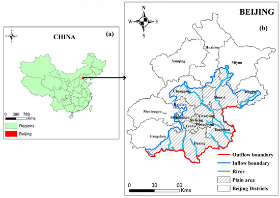
Figure 1.
Study area. (a) General location in China. (b) Beijing Plain area river system and flow boundaries.
2.2. Geological and Hydrogeological Characteristics
The geology of the Beijing Plain is mainly composed of alluvial and lacustrine deposits with pebbles, sand, gravel and clay elements. Based on the Quaternary geological map and the geological archives, the Quaternary stratigraphy of the Beijing Plain can be subdivided into Lower Pleistocene (Q1p), Middle Pleistocene (Q2p), Upper Pleistocene (Q3p) and Holocene (Qh) [29,30]. From the northwest to the southeast, from the mountain front to the plain, the thickness of the Quaternary deposits gradually increase. The hierarchical structure becomes more complex and the grain size of the sediments finer.
The geological model is extracted from Quaternary stratigraphy and combined with borewell data from the “GeoCloud” platform [31]. The location of stable and continuous low-permeability layers is used as a basis for classifying aquifer groups. The Quaternary aquifers in the research area are classified vertically into three main aquifer groups: shallow, medium and deep. Table 1 shows the recharge mode and characteristics of these different aquifers.

Table 1.
Recharge mode and characteristics of research area aquifers.
Based on the distribution of stratigraphic lithology, vadose soil and borewell data collected in conjunction with the current situation of groundwater exploitation and use, the geological model (Figure 2a) and the three-dimensional geological section (Figure 2b) are drawn up in GMS software.
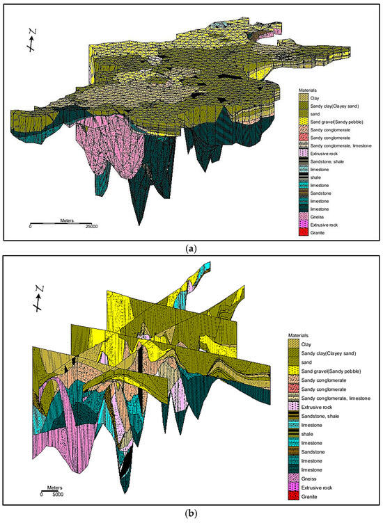
Figure 2.
Research area geological map. (a) Geological model map containing bedrock. (b) Three-dimensional geological section containing bedrock.
3. Materials and Methods
3.1. Conceptual Hydrogeological Model
In conceptual models, all model parameters are prepared as boundary conditions, sources, sinks and observation points. Building the conceptual model of the research area included the following steps:
- Collection of meteorological, hydrological and borehole information.
- Generalized well data, aquifer structure generalization.
- Determination of boundary conditions and initial conditions.
- Zoning of hydrogeological parameters and determination of initial values.
- Calculation of source and sink terms.
All calculations and modeling processes were carried out using Groundwater Modeling System (GMS 10.6) software.
3.1.1. Boundary Conditions
There are two main types of lateral boundaries (Figure 1b). The inflow boundary is the topographic demarcation line between the mountainous areas and the plains in the western, northern and partly eastern parts of the research area. This boundary mainly receives lateral inflow recharge from the mountainous areas which has a larger recharge range and a relatively longer recharge path. Groundwater flow in the eastern and southern parts of the research area is relatively complex along the administrative boundary with Hebei Province. Based on previous studies and observations of groundwater flows in this area, this line is considered as the model outflow boundary. The mountain front boundary was defined as the lateral inflow boundary while the administrative boundary was simulated with the general head boundary in the model. The input values in the model were determined based on data from the Beijing Water Resources Bulletin for the study period.
The shallow aquifer is bound by the water table above. Medium and deep aquifers are separated by impermeable or semi-permeable (leaky) layers depending on the area and considered for the model as confined. Bedrock is considered an impermeable boundary. Recharge of the area through precipitation, river runoff, evapotranspiration and extractions are also considered.
3.1.2. Hydrogeological Parameters
The aquifer’s characteristics in the research area are generally spatially inhomogeneous and anisotropic. In groundwater modeling, the aquifers can be divided into homogenous zones of constant parameters. The hydrogeological parameters of the groundwater flow model considered are the infiltration recharge coefficient of atmospheric precipitation, horizontal and vertical hydraulic conductivity of the aquifer (KH, KV) and the storage coefficient (Ss) (Table 2). The initial values of the parameters of the zones and the individual zones are determined according to the geomorphologic type, stratigraphic lithology, pumping test data and previous studies [32,33,34]. The vertical hydraulic conductivity parameter is generally 1/10 the value of the horizontal hydraulic conductivity parameter and then adjusted during model calibration.
Table 2.
Initial values for hydrogeological parameters of each layer.
Default values for rainfall infiltration coefficients in Table 3 were determined based on the lithology and previous studies conducted on the North China Plain [35,36]. The zoning maps of each parameter are presented in Figure 3.
Table 3.
Default values for rainfall infiltration coefficients by zone.
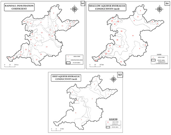
Figure 3.
Zoning maps. (a) Rainfall infiltration coefficient. (b) Shallow groundwater hydraulic conductivity. (c) Deep groundwater hydraulic conductivity.
3.2. Calculation of Source and Sink Terms
Groundwater recharge includes infiltration recharge from precipitation, lateral recharge from the mountain front, infiltration recharge from rivers, ecological recharge and agricultural irrigation. Discharge mainly includes artificial exploitation, lateral discharge and evapotranspiration.
Chaobai River, Yongding River, Juma River and Ji Canal are mainly considered in the evaluation of the groundwater recharge by river. Yongding River has been replenished by water volume through ecological water replenishment measures in recent years which have had a certain impact on groundwater volume. As part of this study, the infiltration volume of rivers and canals will be estimated using Modflow’s RIVER package of GMS 10.6 by introducing the riverbed conductance parameter C (m2/day).
where Dr is the length of the river (m), L is the river width (m), m is the thickness of the riverbed (m) and k0 is the hydraulic conductivity of the riverbed (m/day).
The values of m and k for the riverbed were selected considering data from previous studies and articles. The drilling logs from piezometers installed along the rivers to monitor their evolution were also considered. Mihuaishun, third and fourth water plant sources are part of the projects implemented to restore Beijing’s overexploited groundwater resources. Mihuaishun (Miyun District, Huairou District and Shunyi District) reservoir used to be recharge by local reclaimed water, treated by wetland, and water from the South-to-North Water Transfer Project (SNWTP) [37,38]. The third and fourth water plant sources are subject to very strict operating rules for optimized use of water resources. Details for the calculation and estimation of groundwater recharge and discharge elements are presented in Table 4.
Table 4.
Sources and sink terms calculation and estimation.
3.3. Numerical Modeling with Unstructured Grids Use
3.3.1. Grid Layout of the Area
In this work, GMS software was used to process the model before and after processing. The three-dimensional groundwater flow model in the research area was established based on the MODFLOW USG program.
The spatial discretization of the research area in the plane range adopts the unstructured meshing method based on the finite difference in control volume. The specific partitioning method is as presented in Table 5.
Table 5.
Mesh sections.
The model is vertically divided into three layers, namely a shallow phreatic aquifer and two confined aquifers which are divided into a total of 10,300 units. Figure 4 shows the meshing diagram of the computing domain.
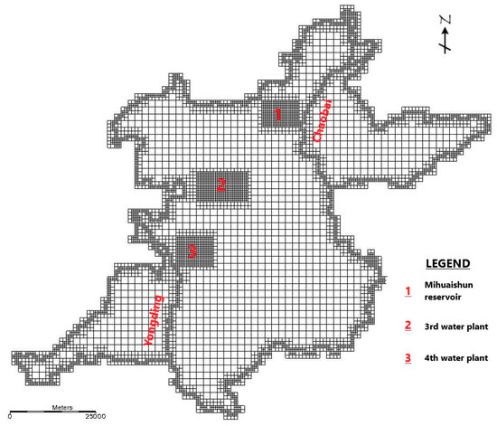
Figure 4.
Unstructured grid profile of the research area.
3.3.2. Model Calibration, Validation and Application
For the model calibration, validation and application, the steps described in Figure 5 are followed:
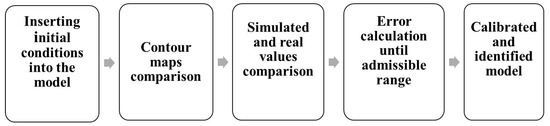
Figure 5.
Model calibration.
Data from 122 long-term groundwater observation wells were collected from the Beijing Municipal Water Bureau over the period from September 2021 to September 2022 for calibration and from September 2022 to February 2023 for validation. It is important to note that most of the available groundwater hydraulic head data concern the shallow unconfined aquifer. The hydraulic heads of confined aquifers were not available. Figure 6 illustrates the spatial distribution of the 34 groundwater observation well data whose validation results are presented in this paper. CY1 designates point 1 for Chaoyang district, DX3 designates point 3 for Daxing district and so on.
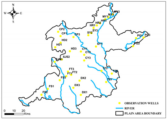
Figure 6.
Spatial repartition for typical observation wells in the study area.
4. Results and Discussion
4.1. Groundwater Flow Model for the Study Area
4.1.1. Initial Conditions
Interpolation was performed on the groundwater level in September 2021 to obtain the initial water level of the groundwater aquifer. Due to the lack of comprehensive long-term continuous observation well data on groundwater levels in the confined aquifers, the initial hydraulic heads of the confined aquifers were not available. The simulation period initial groundwater level map of the shallow unconfined aquifer is shown in Figure 7.
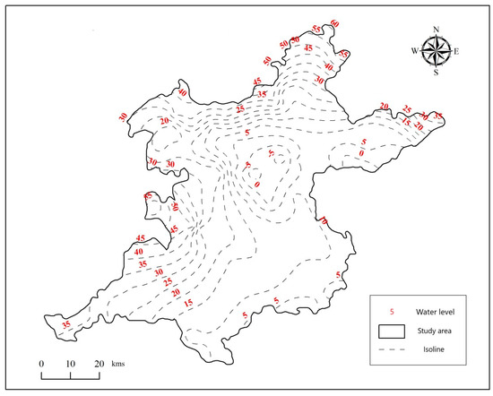
Figure 7.
Groundwater level contour map of the shallow aquifer at the beginning of the simulation period.
4.1.2. Model Calibration
Model calibration is a key step that must be completed before conducting simulation predictions. This simulation takes a period of 12 months from September 2021 to September 2022 as the model calibration period. The calibration period includes a complete hydrological year.
This study collected 122 long-term groundwater observation well data from the groundwater weekly report of the Beijing Municipal Water Bureau [39]. The water level data are relatively continuous, which can play a good role in identifying and verifying the model. A Trial-and-Error Calibration is applied in this study by changing the hydraulic conductivity and recharge values assigned to the polygonal zones and achieves the optimal fit between simulated and observed values. The Observation Head interval which represents the estimated error (±) in the observed value is set to 1.5. This confidence value represents that the confidence in the error estimate is set to 95%. The interval can be used as a calibration target. Calibration is achieved when the error is within the estimated error interval (±1.5 m, in this case) of the observed value. The actual contour map and the model calibration contour map at the end of September 2022 are shown in Figure 8a,b. Figure 8a is a map provided by the Beijing Water Affairs Office. The Chinese names indicate the original names of the elements mentioned in the legend. The simulated flow field basically reflects the trend and pattern of groundwater flow such as the lateral recharge in the front of the mountain, large hydraulic gradient and dense contour lines. The mining intensity in the eastern plain area is relatively weak. The water level difference in the southeast is relatively large due to the lack of groundwater monitoring data at the administrative limit, but it is sufficient to meet the simulation’s needs. Groundwater generally flows in a northwest–southeast direction. The simulation results have a high degree of similarity to the measured results, and the fitting situation is good.
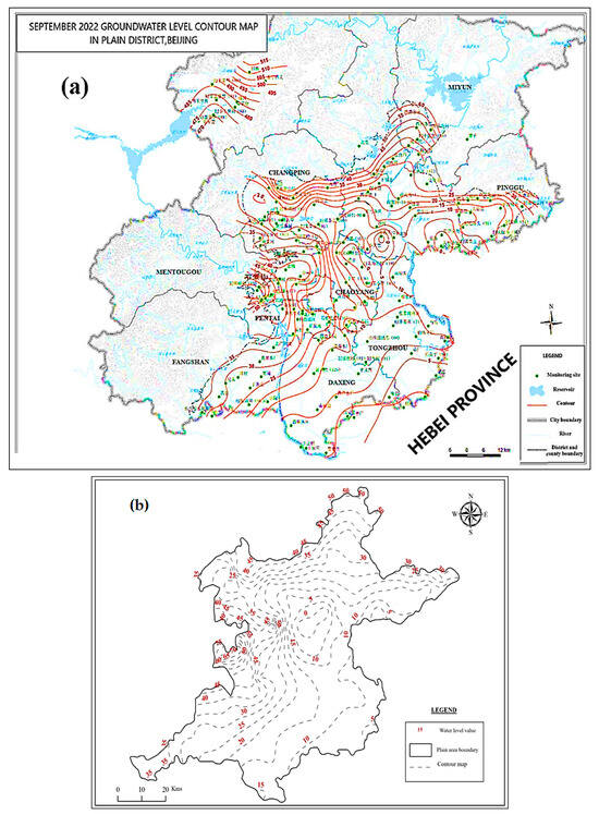
Figure 8.
Contour maps in the shallow aquifer. (a) Groundwater level in the plain area of Beijing in September 2022. (b) Contour map of groundwater level from the model’s calculation.
4.1.3. Model Validation
After completing the model calibration, the model was validated using the observed data for the period September 2022 to February 2023. Of the 122 long-term groundwater level observation wells, 34 typical observation wells were selected in each district to be presented in Table 6.
Table 6.
Validation results for typical observation wells in the study area.
Figure 9 compares the observed with the simulated groundwater level values in selected observation wells tapping the shallow unconfined aquifer.
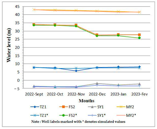
Figure 9.
Graph of water level changes during the validation period (September 2022 to February 2023) in the shallow aquifer.
A table scatter of the observed and simulated groundwater levels reveals a near linear relationship clustered around the 1:1 line with R2 = 0.98, indicating good model accuracy (Figure 10).
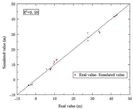
Figure 10.
Scatter plot of observed–simulated values in the shallow aquifer.
From the comparison between the observed and simulated values of groundwater levels and their error statistics (Table 6), some observation points are greatly affected by lateral inflow resulting in relatively large values and local errors. However, the overall average relative error is less than 20% which can meet the needs of the numerical simulation.
From the time series of water level changes (Figure 9) and the scatter plot of simulated observation values (Figure 10), it can be seen that the trend of water level changes calculated by the numerical model can basically represent the overall trend of water level changes. The error control is good, the reliability high and it is relatively consistent with the actual situation.
4.2. Numerical Modeling Calculations of Quartenary Groundwater in the Plain Zone
4.2.1. Groundwater Balance Analysis
From the groundwater balance (Table 7), the difference in balance between total recharge and total discharge in the study area is 463 million m3. The groundwater quantity and water level are in the stage of recovery and rise. Compared with previous studies [5,40] and combined with the current groundwater conditions, the reliability of the equilibrium analysis results is relatively high.
Table 7.
Groundwater balance table (unit = 108 m3).
4.2.2. Groundwater Level Prediction
Based on the established groundwater numerical model, the average rainfall from 2000 to 2020 in the study area is taken as the input for atmospheric precipitation infiltration recharge into the model. With other source sink conditions unchanged, the flow field obtained from the model in September 2022 is used as the initial flow field for the prediction model. The groundwater level dynamics in the study area for the next 5 years, 10 years and 15 years are simulated.
The simulated groundwater flow fields are shown in Figure 11. From Figure 11b to Figure 11d, under current conditions the groundwater level on the simulation period has changed mainly due to the rising trend of the groundwater level depression funnel located in the center of the study area. The range of the groundwater funnel has decreased but the lowest groundwater level is still located in the center of study area. Groundwater is still flowing from the northwest to the southeast.
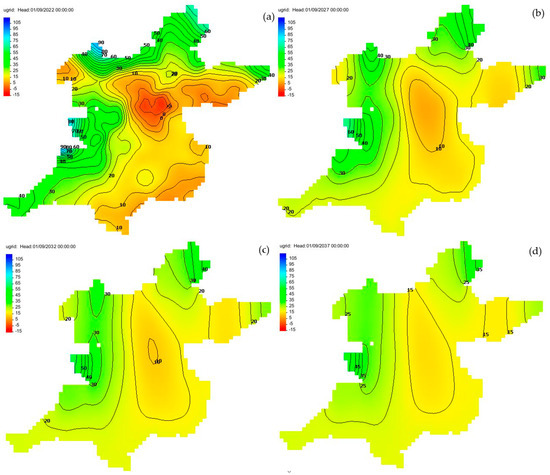
Figure 11.
Groundwater flow field prediction results in the shallow aquifer. (a) 2022 initial flow; (b) 2027 prediction results; (c) 2032 prediction results; and (d) 2037 prediction results.
The groundwater level shows an overall upward trend in the next 15 years. In particular, the groundwater level at the depression cone in the center of the research area continues to rise and the scope of the depression cone decreases and disappears. This is mainly because the mining output of groundwater in the center part was large. After the implementation of the South to North Water Transfer Project (Minhuaishou reservoir, Yongding and Chaobai River ecological water supply) and the implementation of the groundwater hydraulic exploitation policy in Beijing, the artificial mining output decreased. The groundwater level in this area continues to rise and the groundwater level recovers significantly. The model predicts stabilized and significantly increasing groundwater levels at the center of the Beijing area.
5. Conclusions
This study enabled the development of a model for predicting changes in groundwater levels in the Quaternary aquifer of the Beijing Plain area over a given period of time. The method used to establish this model is the USG method performed in GMS 10.6 software with specific spatial discretization for flow boundaries and certain water sources. Based on monitoring data from 122 long-term groundwater observation wells over the past few years, the following conclusions were drawn:
(1) For the comparison of contour maps, the simulation results show a high degree of similarity with the measured results, and the fit is good, indicating that groundwater generally flows in a northwest/southeast direction.
(2) For the comparison of calculated and observed heads, the correlation indicator R2 = 0.98 indicates good model accuracy, and the overall average relative error is less than 20%, which meets the requirements of the numerical simulation.
(3) The comparison of the calculated water balance with the results of numerous studies shows that the reliability of the equilibrium analysis results is relatively high.
(4) The groundwater level was simulated over a period of 15 years. The simulation results indicate that the groundwater level continues to rise. The model predicts stabilized and significantly increasing groundwater levels at the center of the Beijing area.
In conclusion, this calibrated and validated groundwater flow simulation model highlights the influence of the Yongding and Chaobai Rivers, as well as the injection of ecological water from Mihuaishun, the third and fourth water plant sources, on the recharge of the shallow aquifer in the Beijing Plain area. The model can clearly reflect the changing trend of groundwater in the area and can be used for subsequent simulation work such as water level prediction. This study can be further developed and refined by examining the evolution of groundwater in the deeper layers and the integration of some climate and human parameters of the Quaternary aquifer in the plain area of Beijing.
Author Contributions
Conceptualization: Y.Z. and S.F.C.; methodology: Y.Z. and S.F.C.; software: S.F.C.; validation: J.Z.; formal analysis: J.Z.; investigation: S.F.C.; resources: Y.Z.; data curation: S.F.C.; writing—original draft preparation: S.F.C.; writing—review and editing: J.Z. and S.F.C. All authors have read and agreed to the published version of the manuscript.
Funding
This work has been supported by the Beijing Natural Science Foundation [grant number: 8242003]; the Major Science and Technology Innovation Pilot Project for Water Resources Protection and Integrated-Saving Utilization in the Yellow River Basin of Inner Mongolia Autonomous Region [grant number: No. 2023JBGS0007]; supported by Open Research Fund Program of State key Laboratory of Hydroscience and Engineering [grant number: sklhse-2024-C-03]; and is supported by Open Research Fund of Key Laboratory of River Basin Digital Twinning of Ministry of Water Resources [grant number: Z0202042022].
Data Availability Statement
The original contributions presented in this study are included in the article. Further inquiries can be directed to the corresponding authors.
Conflicts of Interest
The authors declare no conflicts of interest.
References
- Hu, L.T.; Wang, Z.J.; Tian, W.; Zhao, J.S. Coupled surface water-groundwater model and its application in the arid Shiyang River basin, China. Hydrol. Process. 2009, 23, 2033–2044. [Google Scholar] [CrossRef]
- Pandian, R.S.; Nair, I.S.; Lakshmanan, E. Finite element modelling of a heavily exploited coastal aquifer for assessing the response of groundwater level to the changes in pumping and rainfall variation due to climate change. Hydrol. Res. 2016, 47, 42–60. [Google Scholar] [CrossRef]
- Xu, Y.-S.; Shen, S.-L.; Cai, Z.-Y.; Zhou, G.-Y. The state of land subsidence and prediction approaches due to groundwater withdrawal in China. Nat. Hazards 2008, 45, 123–135. [Google Scholar] [CrossRef]
- Zhou, Y.; Wang, L.; Liu, J.; Li, W.; Zheng, Y. Options of sustainable groundwater development in Beijing Plain, China. Phys. Chem. Earth Parts A/B/C 2012, 47, 99–113. [Google Scholar] [CrossRef]
- Liu, S.; Zhou, Y.; Tang, C.; McClain, M.; Wang, X.S. Assessment of alternative groundwater flow models for Beijing Plain, China. J. Hydrol. 2021, 596, 126065. [Google Scholar] [CrossRef]
- Enemark, T.; Peeters, L.J.; Mallants, D.; Batelaan, O. Hydrogeological conceptual model building and testing: A review. J. Hydrol. 2019, 569, 310–329. [Google Scholar] [CrossRef]
- Anderson, M.P.; Cherry, J.A. Using models to simulate the movement of contaminants through groundwater flow systems. C R C Crit. Rev. Environ. Sci. Technol. 1979, 9, 97–156. [Google Scholar] [CrossRef]
- Sarma, R.; Singh, S.K. Simulating contaminant transport in unsaturated and saturated groundwater zones. Water Environ. Res. 2021, 93, 1496–1509. [Google Scholar] [CrossRef]
- Seyf-Laye, A.-S.M.; Mingzhu, L.; Djanéyé-Bouindjou, G.; Fei, L.; Lyutsiya, K.; Moctar, B.L.; Honghan, C. Groundwater flow and contaminant transport modeling applications in urban area: Scopes and limitations. Environ. Sci. Pollut. Res. 2012, 19, 1981–1993. [Google Scholar] [CrossRef]
- Panday, S.; Langevin, C.D.; Niswonger, R.G.; Ibaraki, M.; Hughes, J.D. Section A Ground Water in Book Modeling Techniques. U.S. Geological Survey, MODFLOW–USG Version 1: An Unstructured Grid Version of MODFLOW for Simulating Groundwater Flow and Tightly Coupled Processes Using a Control Volume Finite-Difference Formulation; US Geological Survey: Reston, VA, USA, 2013. [Google Scholar]
- Narasimhan, T.N.; Witherspoon, P.A. An integrated finite difference method for analyzing fluid flow in porous media. Water Resour. Res. 1976, 12, 57–64. [Google Scholar] [CrossRef]
- David Krčmář, S.O. MODFLOW-USG: The New Possibilities in Mine Hydrogeology Modelling (or What is Not Written in the Manuals). Mine Water Environ. 2014, 33, 376–383. [Google Scholar] [CrossRef]
- Ezzeldin, M.; El-Alfy, K.; Abdel-Gawad, H.; Abd-Elmaboud, M. Comparison between Structured and Unstructured MODFLOW for Simulating Groundwater Flow in Three-Dimensional Multilayer Quaternary Aquifer of East Nile Delta, Egypt. Hydrol. Curr. Res. 2018, 9, 297. [Google Scholar] [CrossRef]
- Cui, W.-Z.; Hao, Q.-C.; Chen, K.; Chen, F.; Tang, S.-N.; Zhu, Y.-C.; Cao, S.-W. Comparison of Different Grid Refinement Methods in Simulations of Groundwater Recharge by Rivers. J. Earth Sci. Environ. 2020, 42, 394–404. [Google Scholar]
- Liu, S.; Zhou, Y.; Xie, M.; McClain, M.E.; Wang, X.-S. Comparative Assessment of Methods for Coupling Regional and Local Groundwater Flow Models: A Case Study in the Beijing Plain, China. Water 2021, 13, 2229. [Google Scholar] [CrossRef]
- Ji, Z.; Cui, Y.; Zhang, S.; Chao, W.; Shao, J. Evaluation of the Impact of Ecological Water Supplement on Groundwater Restoration Based on Numerical Simulation: A Case Study in the Section of Yongding River, Beijing Plain. Water 2021, 13, 3059. [Google Scholar] [CrossRef]
- Wang, L.; Gao, J.; Zou, C.; Wang, Y.; Lin, N. Water scarcity in Beijing and countermeasures to solve the problem at river basins scale. IOP Conf. Ser. Earth Environ. Sci. 2017, 94, 012132. [Google Scholar] [CrossRef]
- Sun, S.; Fu, G.; Bao, C.; Fang, C. Identifying hydro-climatic and socioeconomic forces of water scarcity through structural decomposition analysis: A case study of Beijing city. Sci. Total Environ. 2019, 687, 590–600. [Google Scholar] [CrossRef] [PubMed]
- Zeng, Z.; Liu, J.; Savenije, H.H.G. A simple approach to assess water scarcity integrating water quantity and quality. Ecol. Indic. 2013, 34, 441–449. [Google Scholar] [CrossRef]
- Zhang, S.; Wang, R.S. Water resources conservation and wastewater reuse in urban China. J. Geogr. Sci. 2010, 20, 631–648. [Google Scholar]
- Liu, J.; Yang, H.; Savenije, H.H. China’s move to higher-meat diet hits water security. Glob. Environ. Change 2015, 33, 133–141. [Google Scholar] [CrossRef]
- Wang, J.; Shang, Y.; Wang, H.; Zhao, Y.; Yin, Y. Beijing’s Water Resources: Challenges and Solutions. JAWRA J. Am. Water Resour. Assoc. 2015, 51, 614–623. [Google Scholar] [CrossRef]
- Qian, L.; Zhang, R.; Hong, M.; Wang, H.; Yang, L. A new multiple integral model for water shortage risk assessment and its application in Beijing, China. Nat. Hazards 2016, 80, 43–67. [Google Scholar] [CrossRef]
- Zhai, Y.; Wang, J.; Teng, Y.; Zuo, R. Hydrogeochemical and isotopic evidence of groundwater evolution and recharge in aquifers in Beijing Plain, China. Environ. Earth Sci. 2013, 69, 2167–2177. [Google Scholar] [CrossRef]
- Chen, B.; Gong, H.; Chen, Y.; Li, X.; Zhou, C.; Lei, K.; Zhu, L.; Duan, L.; Zhao, X. Land subsidence and its relation with groundwater aquifers in Beijing Plain of China. Sci. Total Environ. 2020, 735, 139111. [Google Scholar] [CrossRef] [PubMed]
- Zhai, Y.; Guo, Y.; Zhou, J.; Guo, N.; Wang, J.; Teng, Y. The spatio-temporal variability of annual precipitation and its local impact factors during 1724–2010 in Beijing, China. Hydrol. Process. 2014, 28, 2192–2201. [Google Scholar] [CrossRef]
- Song, X.; Zhang, J.; AghaKouchak, A.; Roy, S.S.; Xuan, Y.; Wang, G.; He, R.; Wang, X.; Liu, C. Rapid urbanization and changes in spatiotemporal characteristics of precipitation in Beijing metropolitan area. J. Geophys. Res. Atmos. 2014, 119, 11250–11271. [Google Scholar] [CrossRef]
- Beijing Municipal Water Affairs. Beijing Water Resource Bulletin 1999–2015; pp. 8–12. Available online: https://swj.beijing.gov.cn/zwgk/szygb/ (accessed on 8 August 2025).
- Wei, W. Beijing Urban Geological Atlas; China Earth Press: Beijing, China, 2008. [Google Scholar]
- Beijing Geological Survey Research Institute. Beijing Regional Geological Report; Beijing Geological Survey Research Institute: Beijing, China, 2018. [Google Scholar]
- Gao, Z. Introduction to “Geology Cloud 3.0”-National Earth Science Big Data Shared Service Platform. China Geol. 2022, 49, 2. [Google Scholar]
- Wang, L. Research on the Model of Sustainable Groundwater Utilization in Beijing Plain Area. Ph.D. Thesis, China University of Geosciences, Beijing, China, 2014. [Google Scholar]
- Wang, L.; Han, J.; Liu, J.; Ye, C.; Zheng, Y.; Wan, L.; Li, W.; Zhou, Y. Groundwater flow simulation in the Beijing Plain. Hydrogeol. Eng. Geol. 2009, 36, 11–17. [Google Scholar]
- Beijing Municipal Bureau of Geology. Groundwater in Beijing; Beijing Municipal Bureau of Geology: Beijing, China, 2008. [Google Scholar]
- Zheng, J.; Teng, Y.; Wang, J.; Hu, L. Assessment of the Groundwater Renewability in Beijing Plain Area. In Proceedings of the 2011 5th International Conference on Bioinformatics and Biomedical Engineering, Wuhan, China, 10–12 May 2011; pp. 1–4. [Google Scholar]
- Meng, S.; Fei, Y.; Zhang, Z.; Lei, T.; Qian, Y.; Li, Y. Research on spatial and temporal distribution of the precipitation infiltration amount over the past 50 years in North China Plain. Adv. Earth Sci. 2013, 28, 923–929. [Google Scholar]
- Huo, L.; Wang, B.; Pan, Z.; Wu, J.; Yang, C. Environmental impact by surface-water recharge of groundwater in Beijing Mihuaishun replenishment area—Correspondence analysis. J. Beijing Norm. Univ. (Nat. Sci.) 2020, 56, 195–203. [Google Scholar] [CrossRef]
- Zhang, D.; Zhang, Y.; Liu, L.; Li, B.; Yao, X. Numerical Simulation of Multi-Water-Source Artificial Recharge of Aquifer: A Case Study of the Mi-Huai-Shun Groundwater Reservoir. Water Resour. 2020, 47, 399–408. [Google Scholar] [CrossRef]
- Beijing Water Authority. Groundwater Dynamics in Beijing Plain District, 2021–2023. Available online: https://swj.beijing.gov.cn/so/s?qt=%E5%8C%97%E4%BA%AC%E5%B9%B3%E5%8E%9F%E5%9C%B0%E5%8C%BA%E5%9C%B0%E4%B8%8B%E6%B0%B4%E5%8A%A8%E6%80%81 (accessed on 8 August 2025).
- Zhou, Y.; Xiao, W.; Wang, J.; Zhao, Y.; Huang, Y.; Tian, J.; Chen, Y. Evaluating Spatiotemporal Variation of Groundwater Depth/Level in Beijing Plain, a Groundwater-Fed Area from 2001 to 2010. Adv. Meteorol. 2016, 2016, 8714209. [Google Scholar] [CrossRef]


Disclaimer/Publisher’s Note: The statements, opinions and data contained in all publications are solely those of the individual author(s) and contributor(s) and not of MDPI and/or the editor(s). MDPI and/or the editor(s) disclaim responsibility for any injury to people or property resulting from any ideas, methods, instructions or products referred to in the content. |
© 2025 by the authors. Licensee MDPI, Basel, Switzerland. This article is an open access article distributed under the terms and conditions of the Creative Commons Attribution (CC BY) license (https://creativecommons.org/licenses/by/4.0/).