A Study on Flood Susceptibility Mapping in the Poyang Lake Basin Based on Machine Learning Model Comparison and SHapley Additive exPlanations Interpretation
Abstract
1. Introduction
- (1)
- To develop a flood inventory with high fidelity by integrating remote sensing data from multiple sources with manual interpretation to overcome the limitations of automated SAR extraction.
- (2)
- To determine the most robust predictive model for this region by systematically comparing the performance of RF, XGBoost, and CNN algorithms optimized by PSO.
- (3)
- To decipher the decision-making mechanisms behind flood susceptibility using the SHAP framework, elucidating both global importance and local nonlinear interactions among driving factors, this objective addresses the interpretability gap.
2. Materials and Methods
2.1. Study Area
2.2. Data Source
2.3. Flood Inventory
2.4. Flood Influencing Factors
2.5. Methods
- (1)
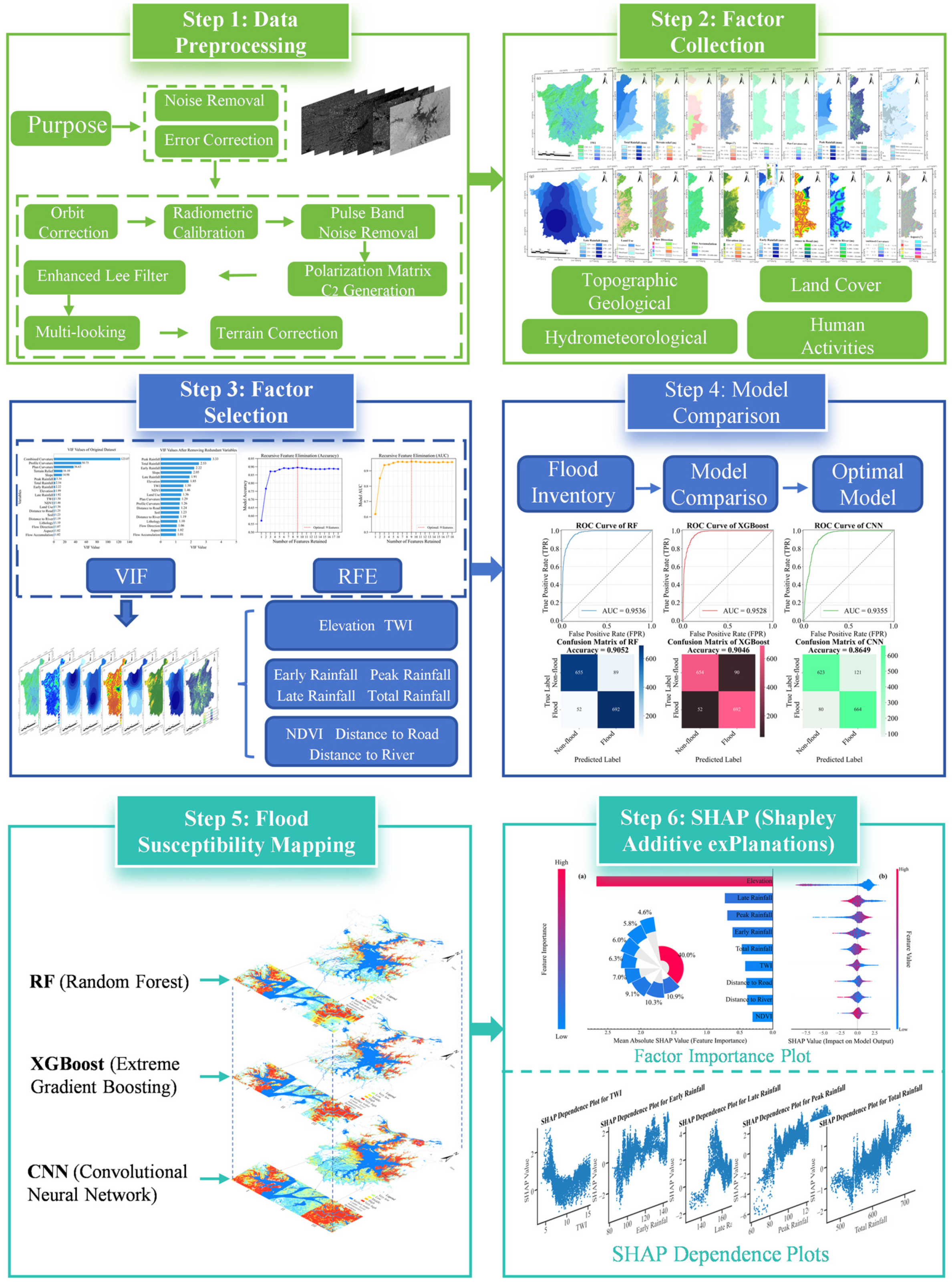
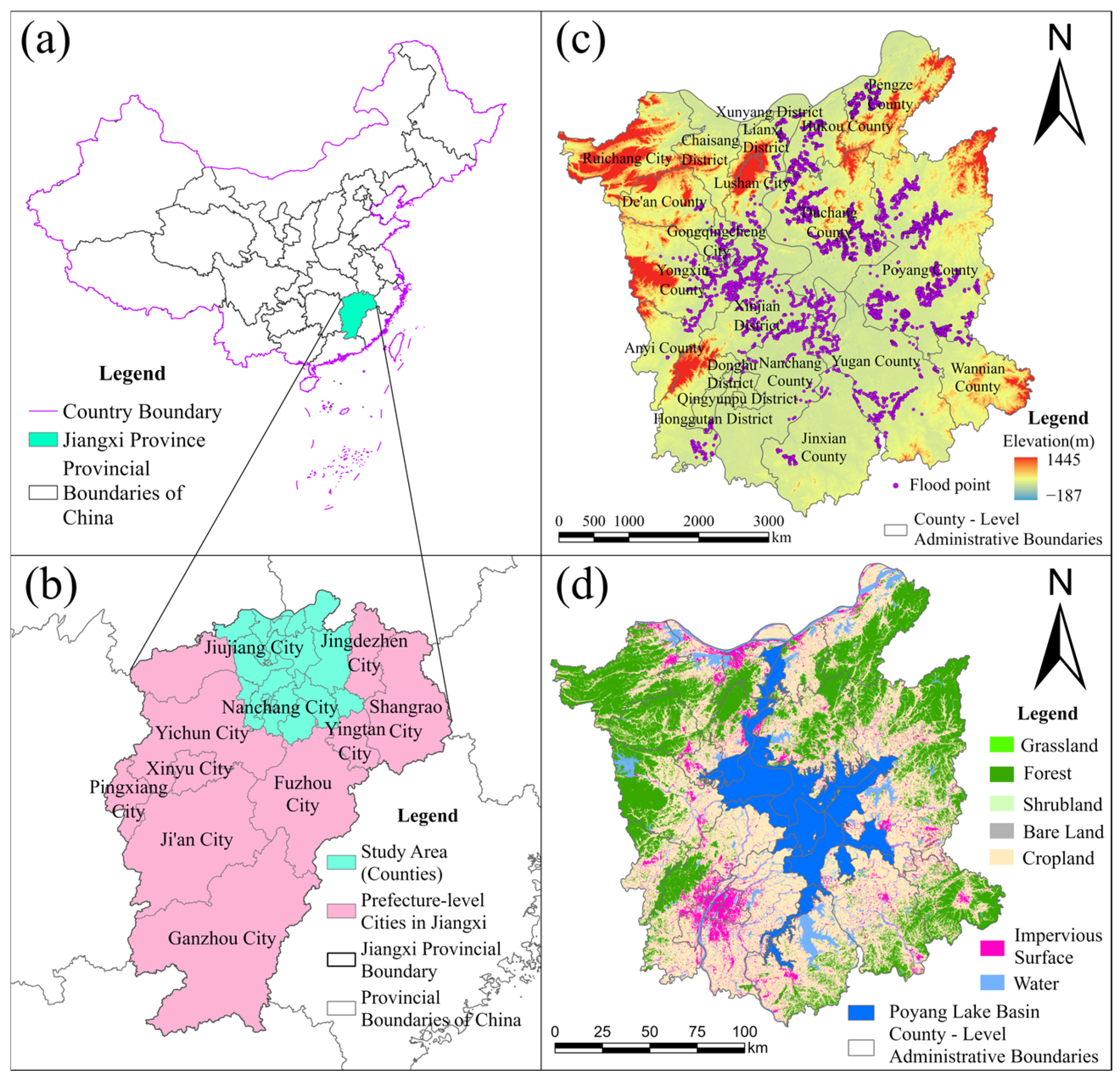
- Geographic Spatial Database Construction: First, based on Sentinel-1 SAR and optical imagery with multiple temporal dimensions, flood inundation areas were manually interpreted and converted into 3720 flood point data points. An equal number of non-flood points were randomly generated in non-inundated areas to form the model training dataset. Next, using data from multiple sources (DEM, precipitation, geology, remote sensing, etc.), 20 preliminary environmental factors were calculated and extracted, including terrain, hydrology, meteorology, and other geological and human activity indicators. Finally, all data underwent unified geospatial registration and resampling processing.
- (2)
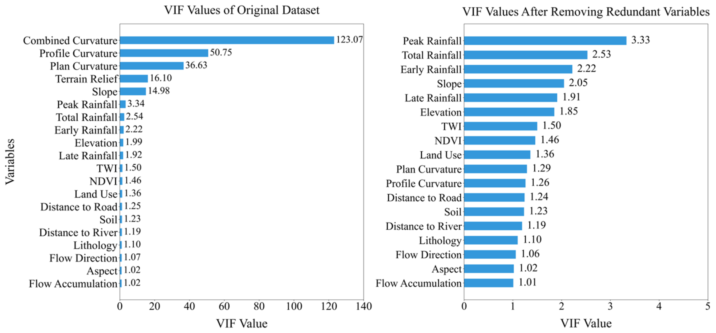
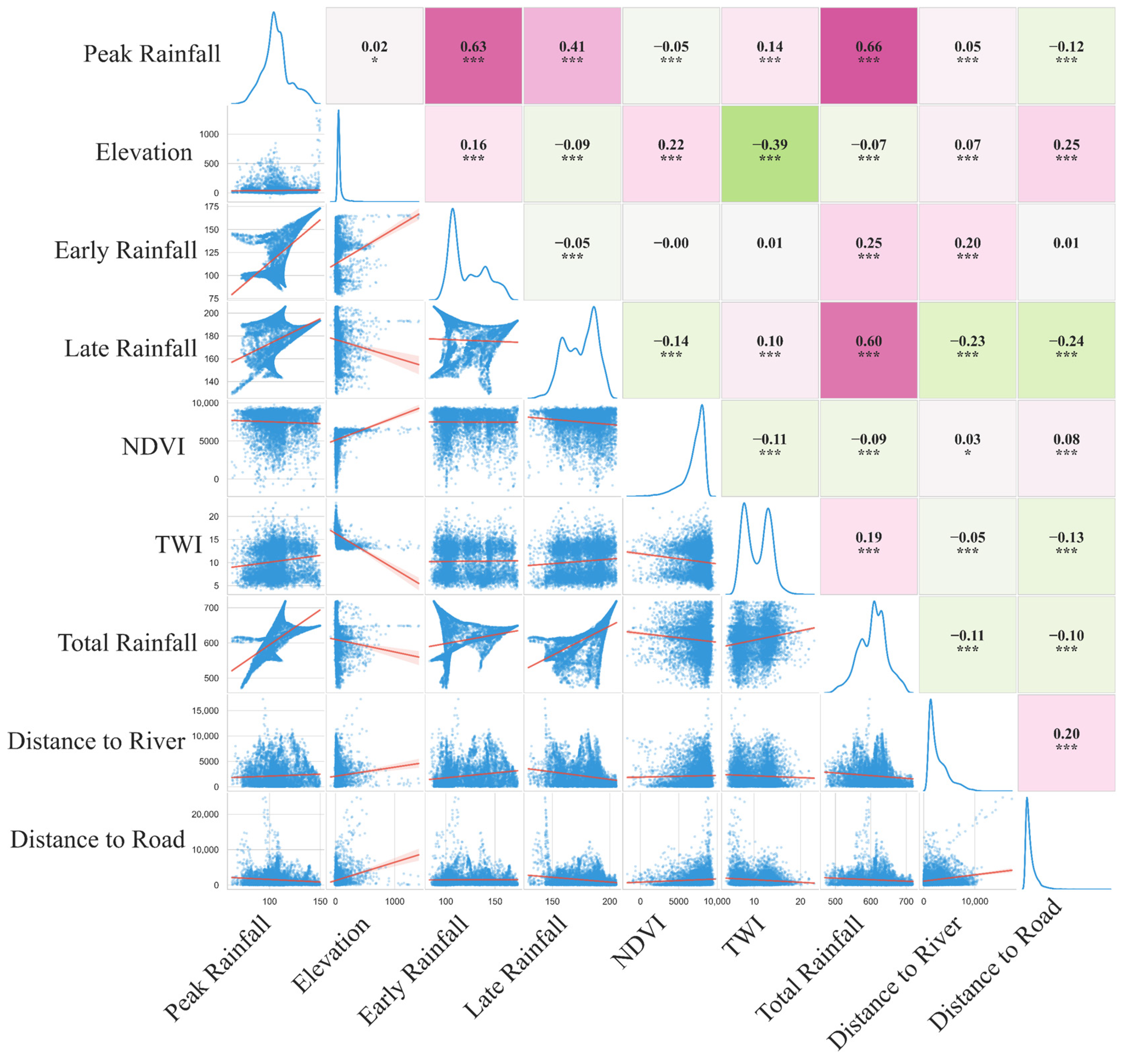
- Feature Selection and Optimization: To eliminate multicollinearity and screen out core driving factors, this paper uses VIF to perform a quantitative analysis of the initial factors, with VIF > 10 as the criterion for determining the existence of severe collinearity [46], through an iterative process, factors with the highest VIF values are eliminated until all remaining factors have VIF values ≤ 5. To further avoid overfitting in subsequent models, the Recursive Feature Elimination (RFE) method is used to select key factors based on the purified factor set [47]. By iteratively evaluating the contribution of features to the explanatory power of the model, features with low contribution to the model are gradually removed, and the optimal feature subset is ultimately retained for subsequent modeling.
- (3)
- Machine Learning Model Construction and Hyperparameter Optimization: Three representative algorithms—RF, XGBoost, and CNN—were selected to construct flood susceptibility prediction models. The PSO algorithm was introduced to automatically optimize the core hyperparameters of each model, with the optimization objective being the area under the curve (AUC) value on the validation set.
- (4)
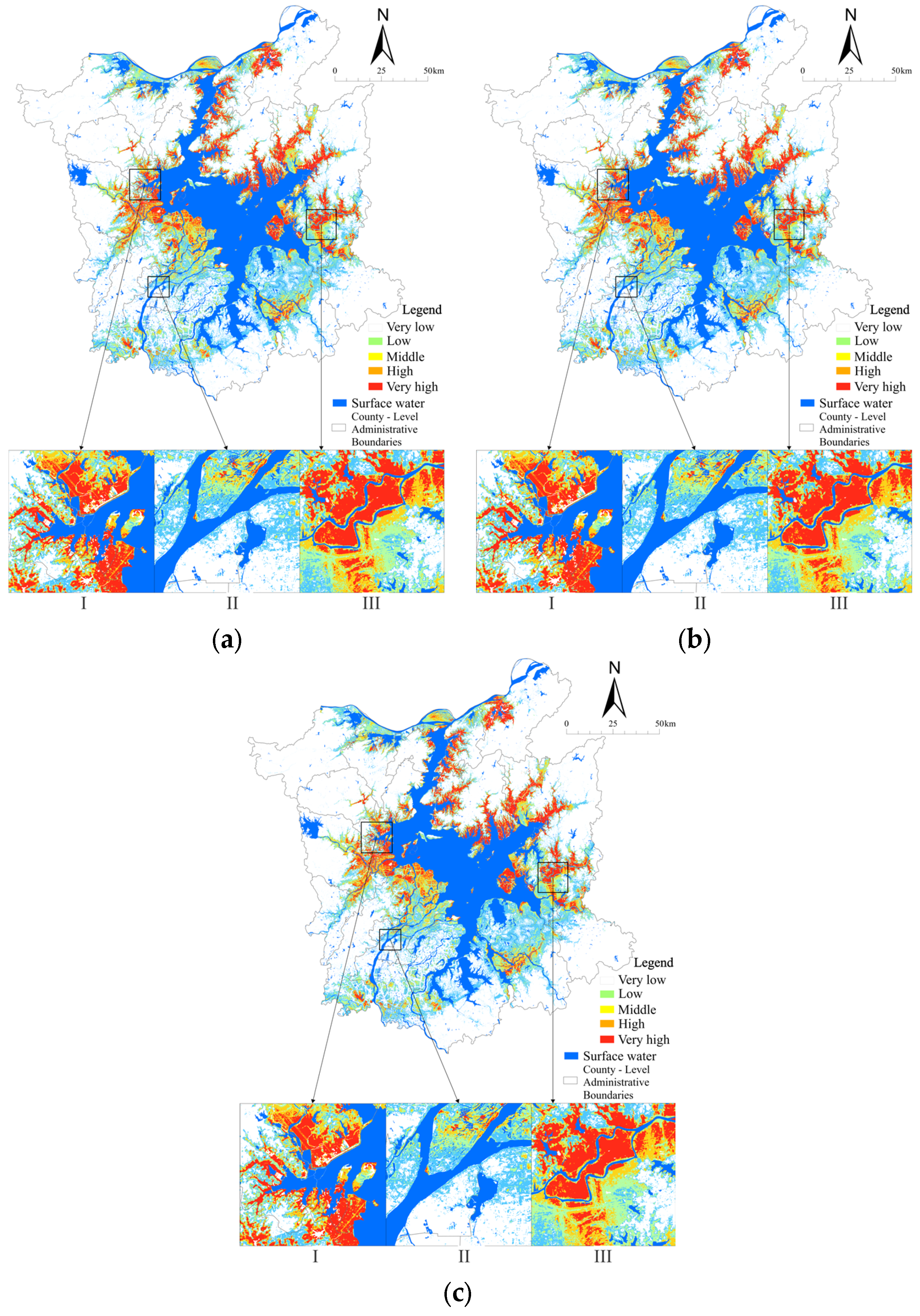
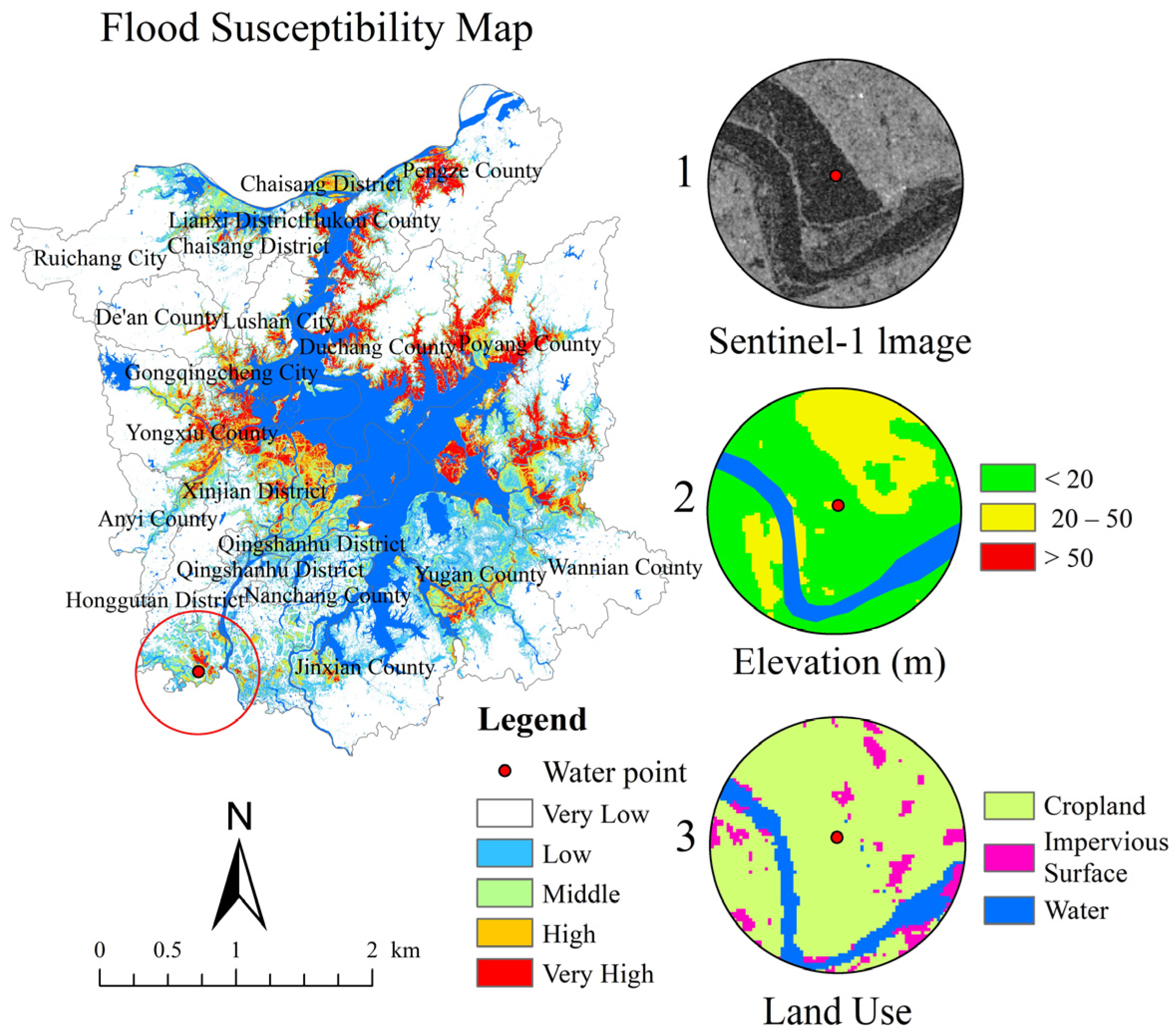
- Model Performance Evaluation and Validation: We quantitatively evaluated and compared the three optimized models on the test set using the AUC and the confusion matrix. Additionally, we used the Jenks Natural Breaks method to classify the flood susceptibility probabilities output by the models into five risk levels: extremely high, high, medium, low, and extremely low, and created a flood susceptibility distribution map.
- (5)
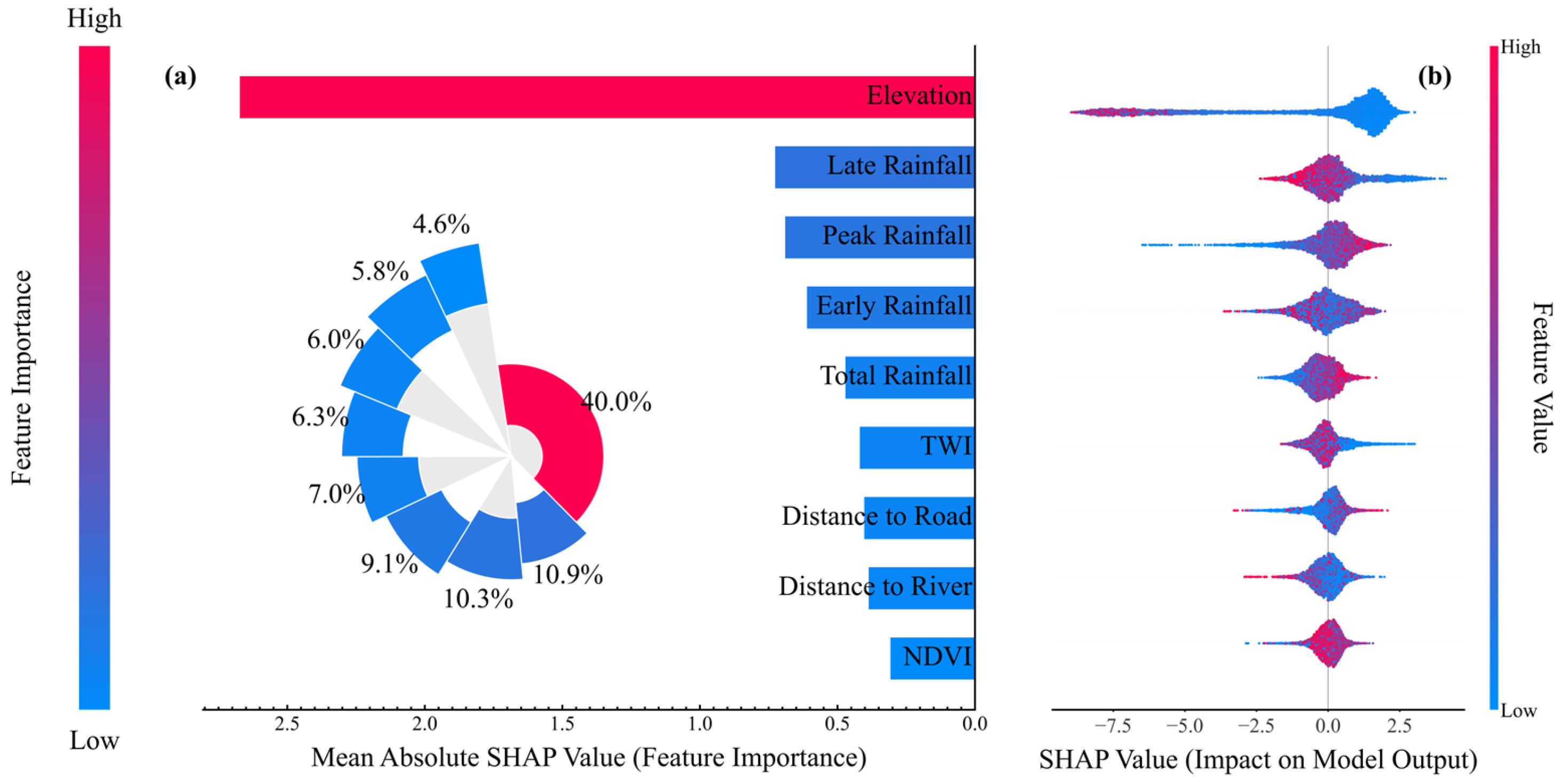
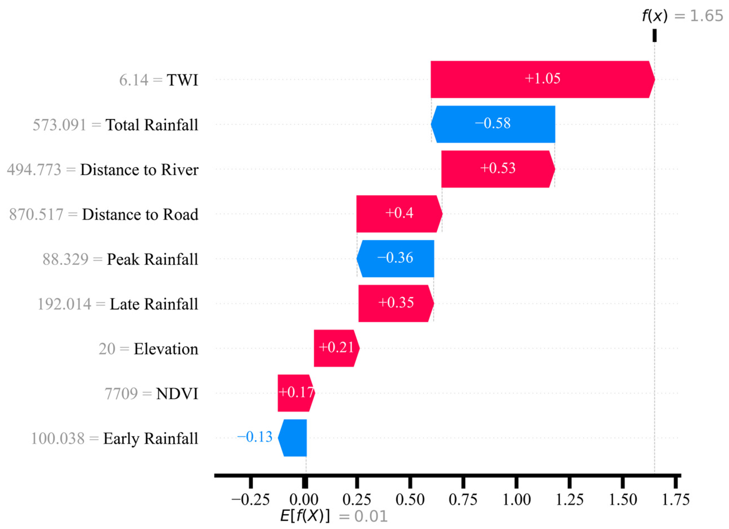
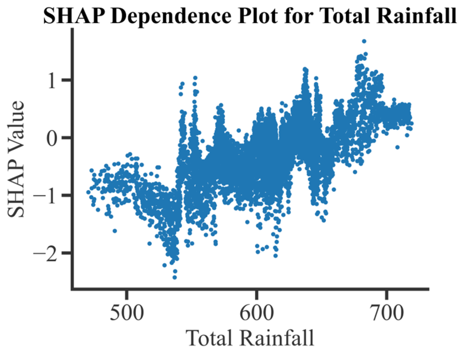
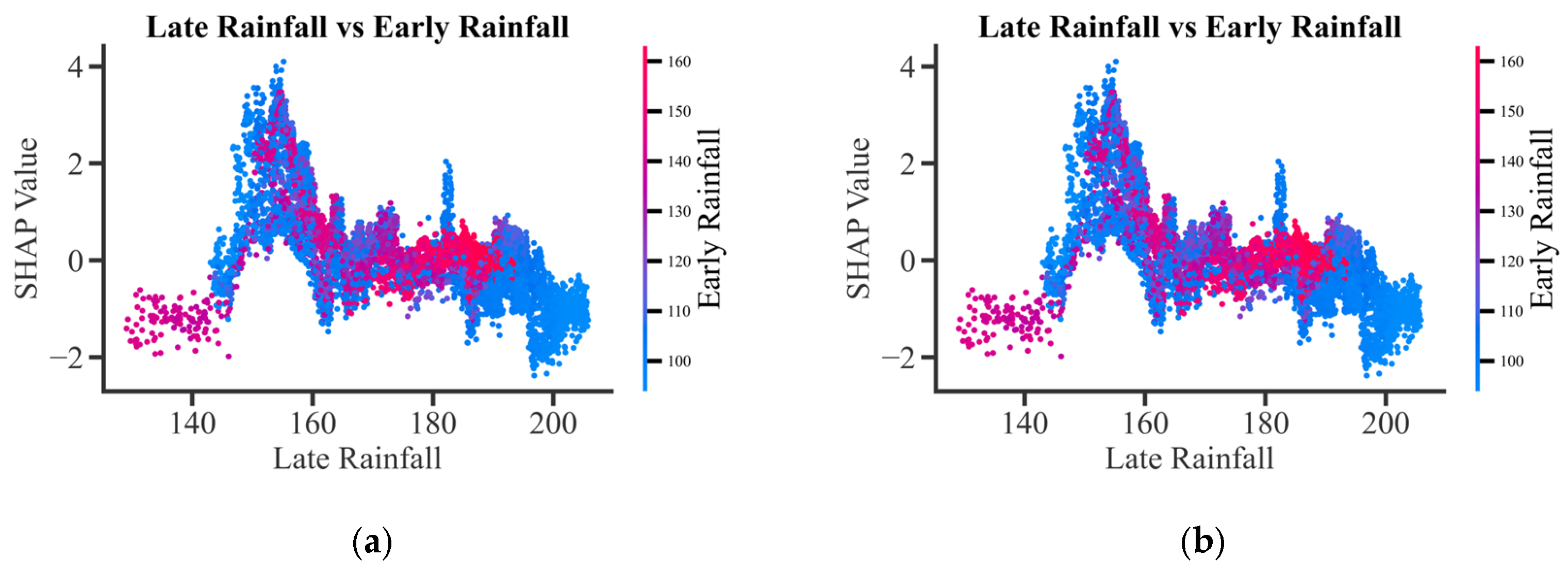
- Explanatory Analysis of Driving Mechanisms: This study employs the SHAP explanatory model to interpret the contribution of each factor, quantifying their average marginal contributions from a global perspective and ranking them accordingly. Additionally, it analyzes the prediction decision-making process for individual samples from a local perspective, thereby revealing the complex relationships among key factors that are not linear and have interactivity.
2.5.1. Random Forest (RF)
2.5.2. Extreme Gradient Boosting Tree (XGBoost)
2.5.3. Convolutional Neural Network (CNN)
2.5.4. Particle Swarm Optimization (PSO)
2.5.5. SHAP Algorithm
3. Results
3.1. Collinearity and Actor Screening
3.2. Feature Selection
3.3. Comparison of Multiple Models
3.4. Flood Susceptibility Zoning Results
3.5. Explanation of the Decision-Making Mechanism for Flood Susceptibility Mapping
3.5.1. Global Factor Importance: Prioritization of Key Disaster-Causing Factors
3.5.2. Global Single-Factor Dependency Analysis
3.5.3. Single Cause Dependency Diagram
4. Discussion
4.1. Comparison of Model Performance and Applicability
4.2. Heterogeneity of Flood Driven Mechanisms
4.3. Interaction Effects of Temporal Rainfall Factors
4.4. Uncertainty Analysis and Limitations
5. Conclusions
- (1)
- RF and XGBoost outperformed the CNN model in the application of FSM in this study area. The RF model achieved the highest prediction accuracy (AUC = 0.9536), effectively capturing the spatial heterogeneity of risk driven primarily by microtopography and demonstrating the greatest applicability to this region. This finding provides a critical empirical benchmark for model selection in complex, human-modified river–lake systems, suggesting that models based on tree ensembles are more adept at handling their disrupted spatial patterns than deep learning models designed for coherent image data.
- (2)
- Globally, topographic factors, particularly elevation, are the primary drivers of flood susceptibility, followed by meteorological factors (late rainfall and peak rainfall). However, SHAP local explanations reveal significant spatial heterogeneity, indicating that the importance ranking and direction of influence of these driving factors dynamically change depending on the geographical context and system state (e.g., backwater conditions). Locally, the TWI can replace elevation as the dominant factor, while high-intensity rainfall factors may even exhibit an inhibitory effect due to the “spatial-risk transfer” mechanism. This underscores a fundamental limitation of relying solely on global explanations and highlights the necessity of multiple-scale, context-specific analysis for accurate local risk assessment and management.
- (3)
- The flood susceptibility of Poyang Lake arises from complex nonlinear interactions between natural geographical factors and human activities. SHAP two-factor analysis revealed a significant interaction between “topography and rainfall,” confirming that unique hydrological and geomorphological processes, such as lake–river backwater effects, modulate the driving mechanisms. This finding underscores the limitations of traditional statistical methods in analyzing such complex systems. More importantly, it reveals that flood drivers are not static but can invert under extreme system states (e.g., backwater saturation), a phenomenon that traditional models fail to capture.
Supplementary Materials
Author Contributions
Funding
Data Availability Statement
Conflicts of Interest
References
- Zhang, J.; Wang, Y.; He, R.; Hu, Q.; Song, X. Discussion on the urban flood and waterlogging and causes analysis in China. Adv. Water Sci. 2016, 27, 485–491. [Google Scholar]
- United Nations Office for Disaster Risk Reduction (UNDRR). Global Assessment Report on Disaster Risk Reduction 2023: Mapping Resilience for the Sustainable Development Goals; United Nations: New York, NY, USA, 2023. [Google Scholar] [CrossRef]
- Zhu, Z.; Zhang, S.; Zhang, Y.; Lu, H.; Feng, X.; Jin, H.; Gao, Y. Flood Risk Transfer Analysis Based on the “Source-Sink” Theory and Its Impact on Ecological Environment: A Case Study of the Poyang Lake Basin, China. Sci. Total Environ. 2024, 921, 171064. [Google Scholar] [CrossRef]
- Nsangou, D.; Kpoumié, A.; Mfonka, Z.; Ngouh, A.N.; Fossi, D.H.; Jourdan, C.; Mbele, H.Z.; Mouncherou, O.F.; Vandervaere, J.-P.; Ndam Ngoupayou, J.R. Urban Flood Susceptibility Modelling Using AHP and GIS Approach: Case of the Mfoundi Watershed at Yaoundé in the South-Cameroon Plateau. Sci. Afr. 2022, 15, e01043. [Google Scholar] [CrossRef]
- Sahana, M.; Rehman, S.; Sajjad, H.; Hong, H. Exploring Effectiveness of Frequency Ratio and Support Vector Machine Models in Storm Surge Flood Susceptibility Assessment: A Study of Sundarban Biosphere Reserve, India. Catena 2020, 189, 104450. [Google Scholar] [CrossRef]
- Tehrany, M.S.; Pradhan, B.; Jebur, M.N. Flood Susceptibility Mapping Using a Novel Ensemble Weights-of-Evidence and Support Vector Machine Models in GIS. J. Hydrol. 2014, 512, 332–343. [Google Scholar] [CrossRef]
- Nkeki, F.N.; Bello, E.I.; Agbaje, I.G. Flood Risk Mapping and Urban Infrastructural Susceptibility Assessment Using a GIS and Analytic Hierarchical Raster Fusion Approach in the Ona River Basin, Nigeria. Int. J. Disaster Risk Reduct. 2022, 77, 103097. [Google Scholar] [CrossRef]
- Karim, F.; Armin, M.A.; Ahmedt-Aristizabal, D.; Tychsen-Smith, L.; Petersson, L. A Review of Hydrodynamic and Machine Learning Approaches for Flood Inundation Modeling. Water 2023, 15, 566. [Google Scholar] [CrossRef]
- Liao, M.; Wen, H.; Yang, L.; Wang, G.; Xiang, X.; Liang, X. Improving the Model Robustness of Flood Hazard Mapping Based on Hyperparameter Optimization of Random Forest. Expert Syst. Appl. 2024, 241, 122682. [Google Scholar] [CrossRef]
- Mosavi, A.; Ozturk, P.; Chau, K.-W. Flood Prediction Using Machine Learning Models: Literature Review. Water 2018, 10, 1536. [Google Scholar] [CrossRef]
- Demissie, Z.; Rimal, P.; Seyoum, W.M.; Dutta, A.; Rimmington, G. Flood Susceptibility Mapping: Integrating Machine Learning and GIS for Enhanced Risk Assessment. Appl. Comput. Geosci. 2024, 23, 100183. [Google Scholar] [CrossRef]
- Wang, Y.; Zhang, P.; Xie, Y.; Chen, L.; Li, Y. Toward Explainable Flood Risk Prediction: Integrating a Novel Hybrid Machine Learning Model. Sustain. Cities Soc. 2025, 120, 106140. [Google Scholar] [CrossRef]
- Ghosh, A.; Siddiqui, A.R. Prediction of Flood Susceptibility in an Inter-Fluvial Region of Northern India Using Machine Learning Algorithms. Nat. Hazards Res. 2024, 5, 468–480. [Google Scholar] [CrossRef]
- Singha, C.; Rana, V.K.; Pham, Q.B.; Nguyen, D.C.; Łupikasza, E. Integrating Machine Learning and Geospatial Data Analysis for Comprehensive Flood Hazard Assessment. Environ. Sci. Pollut. Res. 2024, 31, 48497–48522. [Google Scholar] [CrossRef]
- Samadi, A.; Jafarzadegan, K.; Moradkhani, H. DEM-Based Pluvial Flood Inundation Modeling at a Metropolitan Scale. Environ. Model. Softw. 2025, 183, 106226. [Google Scholar] [CrossRef]
- Dong, Z.; Liang, Z.; Wang, G.; Amankwah, S.O.Y.; Feng, D.; Wei, X.; Duan, Z. Mapping Inundation Extents in Poyang Lake Area Using Sentinel-1 Data and Transformer-Based Change Detection Method. J. Hydrol. 2023, 620, 129455. [Google Scholar] [CrossRef]
- Tian, H.; Wang, J.; Pei, J.; Qin, Y.; Zhang, L.; Wang, Y. High Spatiotemporal Resolution Mapping of Surface Water in the Southwest Poyang Lake and Its Responses to Climate Oscillations. Sensors 2020, 20, 4872. [Google Scholar] [CrossRef] [PubMed]
- Shen, G.; Fu, W.; Guo, H.; Liao, J. Water Body Mapping Using Long Time Series Sentinel-1 SAR Data in Poyang Lake. Water 2022, 14, 1902. [Google Scholar] [CrossRef]
- Pinheiro, G.; Raj, A.; Minz, S.; Choudhury, T.; Um, J.-S. Inundation Extend Mapping for Multi-Temporal SAR Using Automatic Thresholding and Change Detection: A Case Study on Kosi River of India. Spat. Inf. Res. 2024, 32, 311–325. [Google Scholar] [CrossRef]
- Kavats, O.; Khramov, D.; Sergieieva, K. Surface Water Mapping from SAR Images Using Optimal Threshold Selection Method and Reference Water Mask. Water 2022, 14, 4030. [Google Scholar] [CrossRef]
- Zhang, J.; He, Z.; Wang, W.; Sun, Z. Spatial Drivers of Urban Industrial Agglomeration Using Street View Imagery and Remote Sensing: A Case Study of Shanghai. Land 2025, 14, 1650. [Google Scholar] [CrossRef]
- Zhang, Z.; Chen, X.; Xu, C.-Y.; Hong, Y.; Hardy, J.; Sun, Z. Examining the influence of river–lake interaction on the drought and water resources in the Poyang Lake basin. J. Hydrol. 2015, 522, 510–521. [Google Scholar] [CrossRef]
- Wu, Q.; Wang, Z.; Xu, X.; Huang, Z.; Wen, T.; You, W.; Xia, Y. Flood Propagation Characteristics in a Plain Lake: The Role of Multiple River Interactions. Water 2024, 16, 1447. [Google Scholar] [CrossRef]
- Wu, Q.; Xu, B.; Wang, Y.; Zhan, M. Intraseasonal Evolution and Climatic Characteristics of Hourly Precipitation during the Rainy Season in the Poyang Lake Basin, China. Geomat. Nat. Hazards Risk 2021, 12, 1931–1947. [Google Scholar] [CrossRef]
- Shankman, D.; Keim, B.D.; Song, J. Flood Frequency in China’s Poyang Lake Region: Trends and Teleconnections. Int. J. Climatol. 2006, 26, 1255–1266. [Google Scholar] [CrossRef]
- Hu, Q.; Feng, S.; Guo, H.; Chen, G.; Jiang, T. Interactions of the Yangtze River Flow and Hydrologic Processes of the Poyang Lake, China. J. Hydrol. 2007, 347, 90–100. [Google Scholar] [CrossRef]
- Guo, H.; Hu, Q.; Jiang, T. Annual and seasonal streamflow responses to climate and land-cover changes in the Poyang Lake basin, China. J. Hydrol. 2008, 355, 106–122. [Google Scholar] [CrossRef]
- Deng, S.; Wu, Q.; Wang, Z.; Wu, L.; Huang, Z.; Zhang, G. Investigating Flood Characteristics and Mitigation Measures in Plain-Type River-Connected Lakes: A Case Study of Poyang Lake. Water 2024, 16, 281. [Google Scholar] [CrossRef]
- Yu, J.; Li, Y.; Huang, X.; Ye, X. Data Quality and Uncertainty Issues in Flood Prediction: A Systematic Review. Int. J. Digit. Earth 2025, 18, 2495738. [Google Scholar] [CrossRef]
- Saksena, S.; Merwade, V. Incorporating the Effect of DEM Resolution and Accuracy for Improved Flood Inundation Mapping. J. Hydrol. 2015, 530, 180–194. [Google Scholar] [CrossRef]
- Yang, J.; Chen, S.; Duan, Z.; Tang, Y.; Lu, P. Enhancing Flood Susceptibility Predictions by Using Certainty Factor in Non-Flood Selection: A Case Study of Guangdong Province with Four Tree-Based Machine Learning Models. Stoch. Environ. Res. Risk Assess. 2025, 39, 3123–3146. [Google Scholar] [CrossRef]
- Bao, H.; Lann, T.; Ao, X.; Yang, L.; Lan, H.; Peng, J. Evolution Characteristic of Soil Water in Loess Slopes with Different Slope Angles. Geoenviron. Disasters 2024, 11, 43. [Google Scholar] [CrossRef]
- Jiang, C.; Zhu, S.; Feng, J.; Shui, W. Slope Aspect Affects the Soil Microbial Communities in Karst Tiankeng Negative Landforms. BMC Ecol. Evol. 2022, 22, 54. [Google Scholar] [CrossRef]
- Khanifar, J.; Khademalrasoul, A. Multiscale Computation of Different Plan Curvature Forms to Enhance the Prediction of Soil Properties in a Low-Relief Watershed. Acta Geophys. 2024, 72, 933–944. [Google Scholar] [CrossRef]
- Worthington, S.R.H. Impact of Weathering on Permeability-Depth Trends in Bedrock Aquifers. Hydrogeol. J. 2024, 32, 1247–1252. [Google Scholar] [CrossRef]
- Hu, S.; Yang, Z.; Wang, Z.; Galindo Torres, S.A.; Li, L. Self-Organized Criticality of Natural Lakes Revealed by the Percolation Model Based on Topographic Wetness Index. Commun. Phys. 2025, 8, 129. [Google Scholar] [CrossRef]
- Najibi, N.; Devineni, N.; Lu, M.; Perdigão, R.A.P. Coupled Flow Accumulation and Atmospheric Blocking Govern Flood Duration. npj Clim. Atmos. Sci. 2019, 2, 19. [Google Scholar] [CrossRef]
- Zhou, G.; Song, L.; Liu, Y. Parallel Assignment of Flow Directions over Flat Surfaces in Massive Digital Elevation Models. Comput. Geosci. 2022, 159, 105015. [Google Scholar] [CrossRef]
- Zhao, T.; Shao, Q. Detecting Floodplain Inundation Based on the Upstream–Downstream Relationship. J. Hydrol. 2015, 530, 195–205. [Google Scholar] [CrossRef]
- Jahanshahi, A.; Booij, M.J. Quantifying the Relative Contributions of Rainfall and Antecedent Soil Moisture to Flood Generation: Analysis of 963 Iranian Catchments. J. Arid Environ. 2025, 227, 105328. [Google Scholar] [CrossRef]
- Arshad, A.; Mirchi, A.; He, C.; Shah, A.A.; AghaKouchak, A. Anthropogenic and Climatic Drivers of the 2022 Mega-Flood in Pakistan. npj Nat. Hazards 2025, 2, 57. [Google Scholar] [CrossRef]
- Mello, C.R.; Guo, L.; Yuan, C.; Rodrigues, A.F.; Lima, R.R.; Terra, M.C. Deciphering Global Patterns of Forest Canopy Rainfall Interception (FCRI): A Synthesis of Geographical, Forest Species, and Methodological Influences. J. Environ. Manag. 2024, 358, 120879. [Google Scholar] [CrossRef] [PubMed]
- Chen, J.; Chen, Y.; Wang, K.; Zhang, H.; Tian, H.; Cao, J. Impacts of Land Use, Rainfall, and Temperature on Soil Conservation in the Loess Plateau of China. CATENA 2024, 239, 107883. [Google Scholar] [CrossRef]
- Seidel, E. Processes of Soil Infiltration and Water Retention and Strategies to Increase Their Capacity. J. Exp. Agric. Int. 2018, 20, 1–14. [Google Scholar] [CrossRef]
- Mukesh, M.S.; Katpatal, Y.B. Impact of the Change in Topography Caused by Road Construction on the Flood Vulnerability of Mobility on Road Networks in Urban Areas. ASCE-ASME J. Risk Uncertain. Eng. Syst. Part. Civ. Eng. 2021, 7, 05021001. [Google Scholar] [CrossRef]
- Akinwande, M.O.; Dikko, H.G.; Samson, A. Variance Inflation Factor: As a Condition for the Inclusion of Suppressor Variable(s) in Regression Analysis. Open J. Stat. 2015, 5, 754. [Google Scholar] [CrossRef]
- Guyon, I.; Weston, J.; Barnhill, S.; Vapnik, V. Gene Selection for Cancer Classification Using Support Vector Machines. Mach. Learn. 2002, 46, 389–422. [Google Scholar] [CrossRef]
- Breiman, L. Random Forests. Mach. Learn. 2001, 45, 5–32. [Google Scholar] [CrossRef]
- Chen, J.; Li, K.; Tang, Z.; Bilal, K.; Yu, S.; Weng, C.; Li, K. A Parallel Random Forest Algorithm for Big Data in a Spark Cloud Computing Environment. IEEE Trans. Parallel Distrib. Syst. 2017, 28, 919–933. [Google Scholar] [CrossRef]
- Chen, T.; Guestrin, C. XGBoost: A Scalable Tree Boosting System. In Proceedings of the 22nd ACM SIGKDD International Conference on Knowledge Discovery and Data Mining, San Francisco, CA, USA, 13–17 August 2016; pp. 785–794. [Google Scholar]
- Lecun, Y.; Bottou, L.; Bengio, Y.; Haffner, P. Gradient-Based Learning Applied to Document Recognition. Proc. IEEE 1998, 86, 2278–2324. [Google Scholar] [CrossRef]
- Mehta, P.; Bukov, M.; Wang, C.-H.; Day, A.G.R.; Richardson, C.; Fisher, C.K.; Schwab, D.J. A High-Bias, Low-Variance Introduction to Machine Learning for Physicists. Phys. Rep. 2019, 810, 1–124. [Google Scholar] [CrossRef]
- Krizhevsky, A.; Sutskever, I.; Hinton, G.E. ImageNet Classification with Deep Convolutional Neural Networks. Commun. ACM 2017, 60, 84–90. [Google Scholar] [CrossRef]
- Jiang, S.; Qin, S.; Pulsipher, J.L.; Zavala, V.M. Convolutional Neural Networks: Basic Concepts and Applications in Manufacturing. In Artificial Intelligence in Manufacturing; Academic Press: Cambridge, MA, USA, 2024. [Google Scholar]
- Kennedy, J.; Eberhart, R. Particle Swarm Optimization. In Proceedings of the ICNN’95-International Conference on Neural Networks, Perth, WA, Australia, 27 November–1 December 1995; Volume 4, pp. 1942–1948. [Google Scholar]
- Mosalla Tabari, M.; Ebadi, H.; Alizadeh Zakaria, Z. PSO-Random Forest Approach to Enhance Flood-Prone Area Identification: Using Ground and Remote Sensing Data (Case Study: Ottawa-Gatineau). Earth Sci. Inform. 2025, 18, 215. [Google Scholar] [CrossRef]
- Strumbelj, E.; Kononenko, I. An Efficient Explanation of Individual Classifications Using Game Theory. J. Mach. Learn. Res. 2010, 11, 1–18. [Google Scholar]
- Dormann, C.F.; Elith, J.; Bacher, S.; Buchmann, C.; Carl, G.; Carré, G.; Marquéz, J.R.G.; Gruber, B.; Lafourcade, B.; Leitão, P.J.; et al. Collinearity: A Review of Methods to Deal with It and a Simulation Study Evaluating Their Performance. Ecography 2013, 36, 27–46. [Google Scholar] [CrossRef]
- Zhang, X.; Kang, A.; Ye, M.; Song, Q.; Lei, X.; Wang, H. Influence of Terrain Factors on Urban Pluvial Flooding Characteristics: A Case Study of a Small Watershed in Guangzhou, China. Water 2023, 15, 2261. [Google Scholar] [CrossRef]
- Seleem, O.; Ayzel, G.; Bronstert, A.; Heistermann, M. Transferability of Data-Driven Models to Predict Urban Pluvial Flood Water Depth in Berlin, Germany. Nat. Hazards Earth Syst. Sci. 2023, 23, 809–822. [Google Scholar] [CrossRef]
- Zhang, Y.; Ge, T.; Tian, W.; Liou, Y.-A. Debris Flow Susceptibility Mapping Using Machine-Learning Techniques in Shigatse Area, China. Remote Sens. 2019, 11, 2801. [Google Scholar] [CrossRef]
- Hussain, M.A.; Chen, Z.; Wang, R.; Shah, S.U.; Shoaib, M.; Ali, N.; Xu, D.; Ma, C. Landslide Susceptibility Mapping Using Machine Learning Algorithm. Civ. Eng. J. 2022, 8, 209–224. [Google Scholar] [CrossRef]
- Liu, B.; Wen, H.; Di, M.; Liao, M.; Huang, J.; Qian, L.; Chu, Y. Robustness Study of Seismic Hazard Assessment Models Based on Multi-Source Data. Gondwana Res. 2025, 144, 87–108. [Google Scholar] [CrossRef]
- Kaiser, M.; Günnemann, S.; Disse, M. Regional-Scale Prediction of Pluvial and Flash Flood Susceptible Areas Using Tree-Based Classifiers. J. Hydrol. 2022, 612, 128088. [Google Scholar] [CrossRef]
- DeLancey, E.R.; Simms, J.F.; Mahdianpari, M.; Brisco, B.; Mahoney, C.; Kariyeva, J. Comparing Deep Learning and Shallow Learning for Large-Scale Wetland Classification in Alberta, Canada. Remote Sens. 2020, 12, 2. [Google Scholar] [CrossRef]
- Abdalla, K.A.M.H.; Khattab, H.; Tantawy, M.; Mohamed, I.S. Enhancing Pressure Transient Analysis in Reservoir Characterization through Deep Learning Neural Networks. Discov. Appl. Sci. 2024, 6, 473. [Google Scholar] [CrossRef]
- Vemula, S.; Gatti, F.; Jehel, P. Graph Transformer-Based Flood Susceptibility Mapping: Application to the French Riviera and Railway Infrastructure Under Climate Change. arXiv 2025, arXiv:2504.03727. [Google Scholar] [CrossRef]
- Feng, L.; Hu, C.; Chen, X.; Cai, X.; Tian, L.; Gan, W. Assessment of Inundation Changes of Poyang Lake Using MODIS Observations between 2000 and 2010. Remote Sens. Environ. 2012, 121, 80–92. [Google Scholar] [CrossRef]
- Luo, L.; Wang, Y.; Li, Q.; Li, M.; Wang, J.; Zhao, G.; Ma, M. Exploration of the Spatiotemporal Characteristics and Triggering Factors of Flash Flood in China. Ecol. Indic. 2025, 176, 113698. [Google Scholar] [CrossRef]
- Rodopoulos, C.; Saitis, G.; Evelpidou, N. Physical Flood Vulnerability Assessment in a GIS Environment Using Morphometric Parameters: A Case Study from Volos, Greece. Water 2025, 17, 2449. [Google Scholar] [CrossRef]
- Fan, J.; Liu, B.; Lei, T.; Sun, Y.; Ma, Y.; Guo, R.; Chen, D.; Zhou, K.; Li, S.; Gao, X. Exploring How Economic Level Drives Urban Flood Risk. Nat. Commun. 2025, 16, 4857. [Google Scholar] [CrossRef]
- Adnyana, I.M.; Wiguna, P.P.K. Modelling of Flood Hazard Using Topographic Wetness Index in Yeh Ho Watershed, Bali, Indonesia. In Proceedings of the 10th International Conference on Sustainable Agriculture, Food, and Energy (SAFE 2024), Jeju, Republic of Korea, 27–29 June 2024; Volume 159, p. 04002. [Google Scholar] [CrossRef]
- Li, X.; Zhang, Q.; Xu, C.-Y.; Ye, X. The changing patterns of floods in Poyang Lake, China: Characteristics and explanations. Nat. Hazards 2015, 76, 651–666. [Google Scholar] [CrossRef]
- Thomas, J.; Joseph, S.; Thrivikramji, K.; Arunkumar, K. Sensitivity of digital elevation models: The scenario from two tropical mountain river basins of the Western Ghats, India. Geosci. Front. 2014, 5, 893–909. [Google Scholar] [CrossRef]




| Data | Data Source | Type | Spatial Resolution |
|---|---|---|---|
| Elevation | Geospatial Data Cloud | Raster | 30 m |
| River | https://www.openstreetmap.org/ (OpenStreetMap Foundation, London, UK) (accessed on 15 November 2024) | Vector | |
| Precipitation Factors | https://www.ncei.noaa.gov/data/global-summary-of-the-day/archive (NOAA National Centers for Environmental Information, Asheville, NC, USA) (accessed on 19 January 2025) | Raster | 1000 m |
| NDVI | http://www.nesdc.org.cn (accessed on 17 February 2025) | Raster | 30 m |
| Land Use | https://zenodo.org/records/12779975 (accessed on 19 February 2025) | Raster | 30 m |
| Lithology | https://gitcode.com/open-source-toolkit/53e1c/?utm_source=tools_gitcode&index=bottom&type=card&&isLogin=1 (accessed on 8 April 2025) | Vector | |
| Road | https://www.openstreetmap.org/ (OpenStreetMap Foundation, London, UK) (accessed on 15 November 2024) | Vector | |
| Sentinel-1 | Alaska Satellite Facility (ASF) | Raster | 5 m × 20 m |
| Water Level at Hukou Station | http://www.cjh.com.cn/swyb_syqbg.html (accessed on 29 March 2025) |
| Model | Class | Pixel Count | Area (km2) | Proportion (%) |
|---|---|---|---|---|
| RF | Very low | 15,331,415 | 13,798.27 | 62.36 |
| Low | 3,126,034 | 2813.43 | 12.71 | |
| Middle | 2,168,700 | 1951.83 | 8.82 | |
| High | 1,929,767 | 1736.79 | 7.85 | |
| Very high | 2,030,544 | 1827.49 | 8.26 | |
| XGBoost | Very low | 17,423,811 | 15,681.43 | 70.87 |
| Low | 1,958,296 | 1762.47 | 7.96 | |
| Middle | 1,332,112 | 1198.9 | 5.42 | |
| High | 1,342,960 | 1208.66 | 5.46 | |
| Very high | 2,529,281 | 2276.35 | 10.29 | |
| CNN | Very low | 11,266,195 | 10,139.58 | 45.83 |
| Low | 3,553,441 | 3198.1 | 14.45 | |
| Middle | 3,225,684 | 2903.12 | 13.12 | |
| High | 2,889,495 | 2600.55 | 11.75 | |
| Very high | 3,651,645 | 3286.48 | 14.85 |
| Model | Very Low (Count, %) | Low (Count, %) | Medium (Count, %) | High (Count, %) | Very High (Count, %) | Total Count |
|---|---|---|---|---|---|---|
| RF | 0 (0.00%) | 4 (0.11%) | 24 (0.65%) | 163 (4.38%) | 3529 (94.87%) | 3720 |
| XGB | 1 (0.03%) | 10 (0.27%) | 47 (1.26%) | 223 (5.99%) | 3439 (92.45%) | 3720 |
| CNN | 1 (0.03%) | 32 (0.86%) | 177 (4.76%) | 513 (13.79%) | 2997 (80.56%) | 3720 |
Disclaimer/Publisher’s Note: The statements, opinions and data contained in all publications are solely those of the individual author(s) and contributor(s) and not of MDPI and/or the editor(s). MDPI and/or the editor(s) disclaim responsibility for any injury to people or property resulting from any ideas, methods, instructions or products referred to in the content. |
© 2025 by the authors. Licensee MDPI, Basel, Switzerland. This article is an open access article distributed under the terms and conditions of the Creative Commons Attribution (CC BY) license (https://creativecommons.org/licenses/by/4.0/).
Share and Cite
Li, Z.; Tian, J.; Zhu, Y.; Chen, D.; Ji, Q.; Sun, D. A Study on Flood Susceptibility Mapping in the Poyang Lake Basin Based on Machine Learning Model Comparison and SHapley Additive exPlanations Interpretation. Water 2025, 17, 2955. https://doi.org/10.3390/w17202955
Li Z, Tian J, Zhu Y, Chen D, Ji Q, Sun D. A Study on Flood Susceptibility Mapping in the Poyang Lake Basin Based on Machine Learning Model Comparison and SHapley Additive exPlanations Interpretation. Water. 2025; 17(20):2955. https://doi.org/10.3390/w17202955
Chicago/Turabian StyleLi, Zhuojia, Jie Tian, Youchen Zhu, Danlu Chen, Qin Ji, and Deliang Sun. 2025. "A Study on Flood Susceptibility Mapping in the Poyang Lake Basin Based on Machine Learning Model Comparison and SHapley Additive exPlanations Interpretation" Water 17, no. 20: 2955. https://doi.org/10.3390/w17202955
APA StyleLi, Z., Tian, J., Zhu, Y., Chen, D., Ji, Q., & Sun, D. (2025). A Study on Flood Susceptibility Mapping in the Poyang Lake Basin Based on Machine Learning Model Comparison and SHapley Additive exPlanations Interpretation. Water, 17(20), 2955. https://doi.org/10.3390/w17202955


