Article

Reactivation Mechanism of Ancient Accumulation Landslides Synergistically Triggered by Excavation Disturbance and Critical Rainfall Infiltration

1
Guizhou Geological Environment Monitoring Institute, Guiyang 550081, China
2
Guizhou Coal Design and Geological Engineering Co., Ltd., Guiyang 550025, China
3
Guangdong Provincial Key Laboratory of Geodynamics and Geohazards, School of Earth Sciences and Engineering, Sun Yat-sen University, Guangzhou 510275, China
4
College of Resource and Environment Engineering, Guizhou University, Guiyang 550025, China
*
Authors to whom correspondence should be addressed.
Water 2025, 17(17), 2640; https://doi.org/10.3390/w17172640
Submission received: 20 July 2025 / Revised: 26 August 2025 / Accepted: 4 September 2025 / Published: 6 September 2025

Abstract

The reactivation of the Longdongpo ancient colluvial landslide in Sinan County, Guizhou Province represents a typical multi-factor coupled failure. Based on detailed geological investigations and FLAC3D fluid–solid coupling numerical simulations, this study reveals its complex reactivation mechanisms. The analysis demonstrates that long-term groundwater action has significantly weakened the slip zone at the soil–bedrock interface, causing strength degradation and inducing prolonged quasi-stable creep deformation of the slope. The artificial cut slopes formed in the middle-to-lower sections disrupted the original stress field and induced localized plastic deformation. Crucially, the numerical simulation identified a 5 m rainfall infiltration depth as the threshold triggering abrupt instability; when exceeding this critical value (simulated as 10 m and 16 m infiltration depths), pore water pressure surged (>2.7 MPa) and displacement dramatically increased (>2.2 m), reducing shear strength along the potential failure surface to critical levels. This process culminated in the full connection of the shear surface and the landslide’s catastrophic reactivation. This work quantitatively elucidates the chain-reaction mechanism of “long-term groundwater weakening → engineering disturbance initiation → critical-depth rainfall infiltration triggering”, providing vital quantitative evidence for regional ancient landslide risk prevention.

1. Introduction

Landslides, which are common slope geological hazards, refer to the natural phenomenon where slope materials (rock and soil mass) experience overall or partial destabilization and downward movement along a specific weak surface (or zone) under the influence of natural factors (such as river erosion, rainfall, earthquakes, etc.) or human engineering activities [1,2,3]. Characterized by high destructive potential, landslides frequently destroy buildings, block transportation routes, damage farmland, and cause significant casualties and property losses [4,5,6]. Guizhou Province, located in Southwest China, exhibits intensely dissected terrain and complex geological conditions. Coupled with abundant rainfall, it ranks as one of the regions most prone to geological hazards in China [7,8,9]. By the end of 2018, the province had documented 12,231 geological hazard sites. Among these, landslides constituted the highest proportion at 51.6%, posing threats to over 1.45 million people and properties valued at approximately 43 billion yuan [3,9,10]. Colluvial landslides account for a considerable portion of these events. Colluvial landslides describe the instability and sliding of slopes composed of Quaternary and recent loose deposits [11,12,13]. Their slip surfaces are often located at the soil–bedrock interface or within weak intercalated layers [14,15,16]. Notably, many ancient landslides do not remain dormant after their initial formation; instead, they can reactivate during subsequent geological periods due to changes in external conditions, leading to renewed disasters [17,18,19]. The reactivation of ancient landslides has become a critical research topic within colluvial landslide studies. Investigating their reactivation mechanisms is fundamentally important for the accurate prediction and mitigation of such hazards [18,20,21,22].
Over the years, extensive research has been conducted by domestic and international scholars on the genetic mechanisms of colluvial landslides and ancient landslide reactivation. Scholars have employed various methods, including analysis of engineering case histories [23,24,25], in situ monitoring [26,27,28,29], physical model testing [30,31,32], and numerical simulation [33,34,35,36], to deeply investigate the driving mechanisms and effects of key factors such as rainfall infiltration [37,38,39], seismic activity [40,41,42], reservoir water level fluctuations [20,32,43,44], artificial excavation deformation disturbance [45,46,47], and changes in regional hydrogeological conditions [48,49,50] in the formation of colluvial landslides or reactivation of ancient landslides. This work has established multiple theoretical models and accumulated valuable practical experience [51,52,53,54,55]. Among these, the theory of pore water pressure effects, based on the principle of effective stress and the Mohr–Coulomb strength criterion, is widely applied to explain soil strength degradation and increased driving forces caused by rainfall infiltration or reservoir level changes [56,57,58]. The stress–strength relationship evolution model is commonly used to analyze how engineering activities (e.g., toe excavation, loading) drive the redistribution of stress states and reduction in shear strength along potential/pre-existing slip surfaces [59,60,61]. Furthermore, the theory of geological environment cumulative effects emphasizes the persistent influence of long-term groundwater action (e.g., softening, argillization, and weathering erosion) on weakening slip zones, particularly soil–bedrock interfaces [62,63,64]. For the complex coupling of multiple factors, the multi-field (hydro-mechanical–chemical) coupling-induced mechanism theory is employed to comprehensively analyze the inherent complexity of how interactions between various triggering factors (e.g., earthquake + rainfall, excavation + rainfall, reservoir fluctuation + rainfall) promote ancient landslide reactivation [33,65,66].
Located on the west bank of the Wujiang River within the urban area of Sinan County, Guizhou Province, the Longdongpo landslide (Figure 1) represents a typical case of ancient colluvial landslide reactivation. Its reactivation involves complex multi-factor coupling effects, notably long-term groundwater action, artificial excavation disturbance, and rainfall. Although previous research on landslides with similar geological backgrounds and triggers is substantial, detailed studies on the precise reactivation mechanisms of ancient landslides like Longdongpo—characterized by significant long-term groundwater activity and specific excavation history—remain insufficient. The full process mechanism involving long-term seepage-softening by groundwater, stress field reorganization and seepage path alteration due to excavation, and the coupled effects of rainfall infiltration at varying intensities requires in-depth analysis. Based on detailed geological investigation, this study focuses on the reactivation mechanism of the Longdongpo ancient colluvial landslide, adopting it as a representative case. Integrating engineering geological dissection, deformation evolution process back-analysis, and FLAC3D seepage–stress coupling numerical simulation, it aims to (1) systematically characterize the basic features of the landslide; (2) quantitatively reveal the synergistic disaster-inducing mechanism encompassing long-term groundwater weakening, excavation disturbance, and intense rainfall infiltration, with particular emphasis on the critical effect of the key rainfall infiltration depth and its internal process triggering overall reactivation. The findings will provide quantitative scientific support for the precise identification and mitigation of similar regional hazards.

2. Landslide Overview

The Longdongpo landslide is situated on the mid-slope of the west bank of the Wujiang River within the urban area of Sinan County, with geographical coordinates of 108°25′12″ E, 27°95′78″ N. Overall, it is located within a “trough-shaped” valley, with a “armchair-shaped” back scarp. It existed as an “ancient landslide” in its original state. The slope gradient in the mid-upper section ranges from 10° to 20°, and in the mid-lower section from 15° to 30°. The rear zone represents the boundary between steep and gentle topography, with the steep slope immediately behind the rear scarp having gradients of approximately 30° to 45°. Both the left and right boundaries of the landslide are defined by gullies. The front elevation ranges from 385 to 390 m, while the rear elevation ranges from 460 to 490 m. The preferred sliding direction is 92°, and the landslide displays a “tongue-shaped” planform, representing the reactivation of the entire ancient landslide body. The landslide body extends approximately 650 m longitudinally and 100~300 m transversely. The thickness of the sliding mass is unevenly distributed: approximately 10–20 m at the front, 10–16 m in the middle section, and 5–8 m at the rear, with an average thickness of about 12 m. The landslide volume is about 1.6 million m3, classifying it as a large, medium-thickness colluvial landslide (Figure 1).
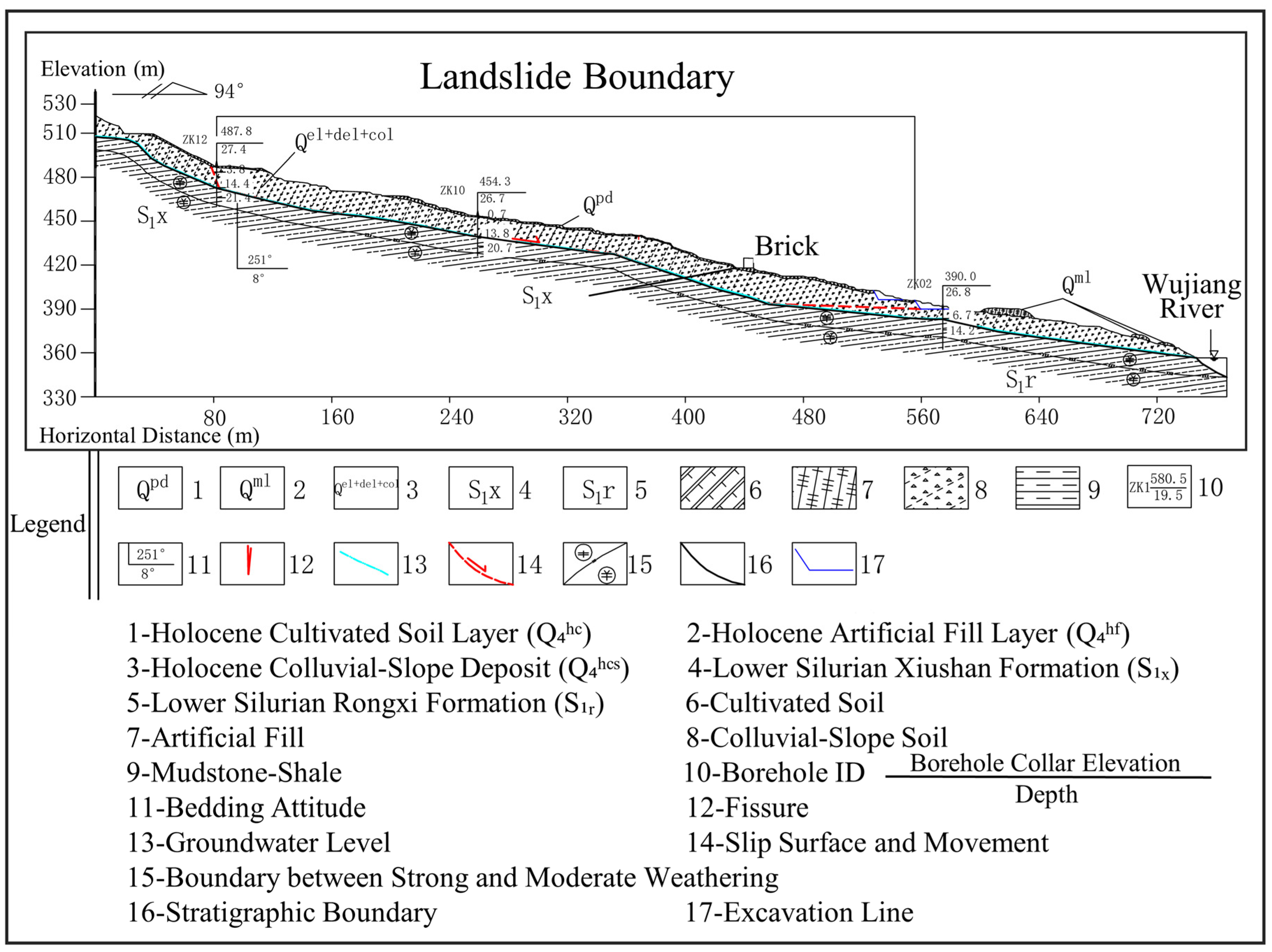
The sliding mass primarily consists of silty clay with rock fragments, locally including limestone blocks mixed with red clay. The rock fragments are predominantly limestone, exhibiting significant spatial variation in size and distribution. The content of gravel and blocks (size typically 2–200 mm and >200 mm, respectively) ranges from 10% to 30% with considerable variation in particle size. In localized areas and at greater depths, the sliding mass comprises gravelly soil, mainly composed of gravel and blocks, with silty clay filling the interstices between the rock fragments. The depth to the sliding bed generally varies from 1.3 to 20.4 m. The bedrock profile overall exhibits characteristic features of a stepped, polyline shape: steeper in the rear (dip angle ~25°), relatively gentle in the mid-upper and middle sections (dip angles ~9–12°), and moderately steep in the mid-lower section (dip angles ~9–18°) (Figure 2). The sliding bed is primarily formed by intensely weathered mudstone belonging to the lower-middle Silurian Xiushan Formation (S1x) and Rongxi Formation (S1r). Locally, the basal material comprises Holocene Quaternary silty clay with rock fragments (Figure 3). The slip zone at the upper and middle parts is situated at the soil–bedrock interface, while the lower slip zone is located within the sliding mass itself. Based on deformation characteristics, the main material composition of the slip zone is largely consistent with that of the sliding mass, consisting of gravelly soil.

3. Qualitative Analysis of Landslide Causative Factors

The triggering mechanisms of the Longdongpo landslide differ significantly from typical rainfall-induced failures. Its reactivation primarily stemmed from prolonged groundwater activity driving the slope toward critical equilibrium, with anthropogenic interventions and recurrent rainfall precipitating comprehensive failure of the ancient landslide mass. Key chronological developments include early 2011 construction activities involving a 3–5 m excavation at the mid-lower slope, which formed a high, steep free face and induced localized deformation under intense August 2011 rainfall; late 2012 to early 2013 leveling operations near Zhonghua North Road, which generated additional free faces on the landslide’s right front flank, further compromising stability; and post-May 2013 remediation works that damaged drainage infrastructure, altering surface and subsurface runoff pathways. This cascade of disturbances triggered renewed displacement culminating in full reactivation.
(I)
Stage I: Rear Scarp Surface Creep (March/April 2011)
The evolutionary sequence comprises three phases (Figure 4). Stage I (March–April 2011) featured rear scarp deformation after intense rainfall elevated groundwater levels, initiating surface creep. Three transversely oriented, segmented tension cracks propagated downslope, accompanied by secondary fissures. During dry intervals, sustained creep under gravitational and groundwater forces caused compression-induced bulging at the mid-lower slope’s steep-gentle junction. Crucially, the midsection’s broad platform and substantial colluvium thickness temporarily maintained global stability (Figure 4a,b).
(II)
Stage II: Front Excavation-Midsection Creep (End of 2011–Early 2013)
Stage II (late 2011–early 2013) commenced with sequential excavations first in the mid-lower slope (late 2011) and later near Zhonghua North Road (late 2012–early 2013), disrupting stress equilibria and concentrating stresses at cut slopes. Concurrently, rear mass creep intensified, widening tension cracks and amplifying thrust forces. This triggered radial dilation cracks—fanning from topographic convexities—at mid-lower transitional zones during rainfall events. Accelerated infiltration through fractures altered seepage fields, directing groundwater toward the midsection. The synergy of elevated pore pressures, rear mass thrust, and newly created free faces progressively destabilized the central and lower slope segments (Figure 4c).
(III)
Stage III: Progressive Shear Surface Connection-Comprehensive Reactivation Failure (2013 onwards)
Stage III (2013 onward) represented the decisive rupture phase. Prolonged saturation progressively softened and argillized the intensely weathered mudstone caprock, degrading its shear strength until persistent movement reduced it below mobilized shear stresses along the incipient failure surface. Ultimately, progressive shearing interconnected localized rupture zones, triggering full reactivation of the ancient landslide (Figure 4d).

4. Three-Dimensional Numerical Analysis of Landslide Causative Mechanism

4.1. Model Overview

A fluid–solid coupling numerical analysis of the landslide body was conducted using FLAC3ᴰ software (version 5.0) [67]. The soil–rock mass was modeled as a porous medium, with fluid flow governed by Darcy’s law, adhering to the Fourier–Biot constitutive relations. The computational procedure involved first executing a standalone seepage field simulation using the seepage module. The resultant pore pressure distributions were then sequentially transferred as inputs to a mechanical step. The computed stress field data from this step were subsequently imported back into an updated seepage field calculation. This iterative, sequential solution procedure, cycling between the seepage and stress solvers, converged upon a coupled steady-state solution satisfying both fields.
Based on pre-failure surface topography and borehole data and grounded in a clear understanding of the geological prototype and conceptual model, the geometry was simplified into two main domains: the sliding mass and the underlying bedrock. The primary material interfaces modeled were the residual–colluvial gravelly soil and the bedrock. A representative domain was generated using Midas GTS NX: the model extent aligns with a right-handed Cartesian coordinate system where X (836 m) is positive downslope, Y (640 m) positive along the Wujiang River direction, and Z (ranging from 114 m to 328 m elevation) positive upward. The model, meshed with tetrahedral elements, was imported into FLAC3D. The element sizes range from 2 to 15 m, with refinement applied near the ground surface and within the sliding band zone. The final mesh comprises 49,351 nodes and 212,783 elements. Figure 5 illustrates the mesh configuration and material group distribution.

4.2. Boundary and Initial Conditions

(1)
Initial Conditions
The initial stress state corresponded to the slope under natural (non-rainfall) conditions, incorporating solely gravity-induced stresses and hydrostatic pore pressures.
(2)
Hydraulic Head Boundary Conditions
Lateral boundaries were defined as impermeable. The slope surface was a permeable, atmospheric pressure boundary. At any node, negative pore pressures automatically defined a flow (infiltration/seepage face) boundary, while positive pore pressures invoked an equivalent pressure boundary condition. The model base was impermeable.
(3)
Displacement Boundary Conditions
Displacements were fixed in all directions (x, y, z) on the base boundary. The slope surface remained a free boundary. Lateral faces employed roller-type conditions allowing motion parallel to the respective face (i.e., fixed normal to the face boundary).

4.3. Material Parameter Selection

(1)
Rock-Soil Mass Physico-Mechanical Parameterization
Based on the original topography, the computational model defines two primary geological materials: gravelly soil and bedrock (silty mudstone). The mechanical parameters, listed in Table 1, were determined through laboratory tests, consideration of relevant geotechnical codes, and field calibration to match site conditions. Critically, the bedrock (comprising intensely weathered Silurian mudstone) exhibits extremely low permeability (field investigation measured permeability coefficient <10−7 m/s). Furthermore, its weathered fractures are predominantly infilled with clay, rendering it effectively impermeable relative to the overlying soil. Therefore, in the numerical model, its permeability coefficient was set to <10−9 m/s (approximating an impermeable boundary), a treatment consistent with the prevailing hydrogeological conditions.
(2)
Rainfall Scenario Parameterization
The reactivation of the Longdongpo landslide is synergistically controlled by prolonged groundwater effects and rainfall infiltration. Meteorological records from Sinan County indicate that the primary rainfall in 2013 occurred during May–July. Notably, no significant heavy rainfall event preceded the major reactivation episode in late July, suggesting a deformation lag. Hence, the key triggering factor was the disturbance to the pre-existing drainage system by remediation works implemented at the landslide’s rear margin in May (Figure 4c). This disruption substantially reduced the slope’s effective drainage capacity, significantly prolonging rainwater retention time.
Due to the absence of laboratory-measured soil–water characteristic curve (SWCC) parameters for the slip zone material (gravelly silty clay), the reliability of transient seepage simulations was deemed insufficient. Therefore, this study stylized the lagged cumulative effect of historical rainfall using a steady-state saturation depth (h) as a controlling parameter for analysis.
Given the pronounced spatial variability in landslide body thickness (10–20 m near the front, 10–16 m in the middle, and 5–8 m at the rear), five distinct saturation depth scenarios were established, calibrated to this thickness distribution. These scenarios systematically investigate the impact of varying saturation degrees on slope stability. Scenario 1: h = 0.2 m (simulating surface wetting state); Scenario 2: h = 1 m (simulating shallow infiltration influence); Scenario 3: h = 5 m (simulating saturation in the upper region of the slip zone); Scenario 4: h = 10 m (simulating saturation within the middle landslide body); Scenario 5: h = 16 m (simulating near-complete or full saturation of the landslide body) The h = 5 m scenario specifically targets the potential saturation state near the slip zone at the rear margin, identified as a critical depth point for analyzing abrupt stability changes.
Each scenario was analyzed through 4000 hydro-mechanical time steps. This number was determined robustly based on extensive sensitivity testing, confirming its adequacy for achieving convergence in displacement, pore pressure distribution, and development of plastic zones under the stipulated steady-state infiltration boundary conditions (constant h per scenario). Model convergence satisfied the requirements for steady-state analysis, effectively revealing the slope’s progressive response towards the final equilibrium state under varying saturation depths. Detailed results, including displacement fields and pore pressure distributions, are presented in Section 4.5.

4.4. Computational Procedure

(1)
Initial Stress State Validation: An initial simulation of the slope under natural conditions established a benchmark, verifying model stability and parameter appropriateness. Upon successful completion, all accumulated displacements were reset to zero before applying subsequent disturbance perturbations. This step was crucial for assessing subsequent stability changes relative to the verified initial state.
(2)
Anthropogenic Excavation Simulation: Slope modifications via mid-lower and front-flank excavations were simulated. Using the original topography as a baseline, excavation sequences followed actual engineering sequences (top-down) based on cut-fill design lines. Stability changes induced purely by excavation were analyzed.
(3)
Rainfall Infiltration Impact Simulation: The saturated infiltration scenarios examined the destabilizing effects of (i) elevated groundwater tables softening the basal slip zone material, (ii) increased driving forces due to rising saturated unit weight, and (iii) destabilizing seepage-induced hydrodynamic pressures. Fluid–solid coupling was explicitly activated for these analyses. Longdongpo landslide is situated in the mid-slope section, with a longitudinal extent of approximately 650 m and a width ranging between 100 and 300 m. The landslide toe is located about 160 m from the contemporary riverbed. The toe elevation (385–390 m) significantly exceeds the normal pool level (365 m) of the dam reservoir. Consequently, the influence of reservoir water levels is disregarded in this study given the substantial elevation difference.

4.5. Analysis of Simulation Results

4.5.1. Evolution of Stress Field Characteristics

FLAC3D simulation results (stress sign convention: tension = positive “+”; compression = negative “−”; pore pressure positive in compression) reveal a three-stage evolutionary response in the stress field:
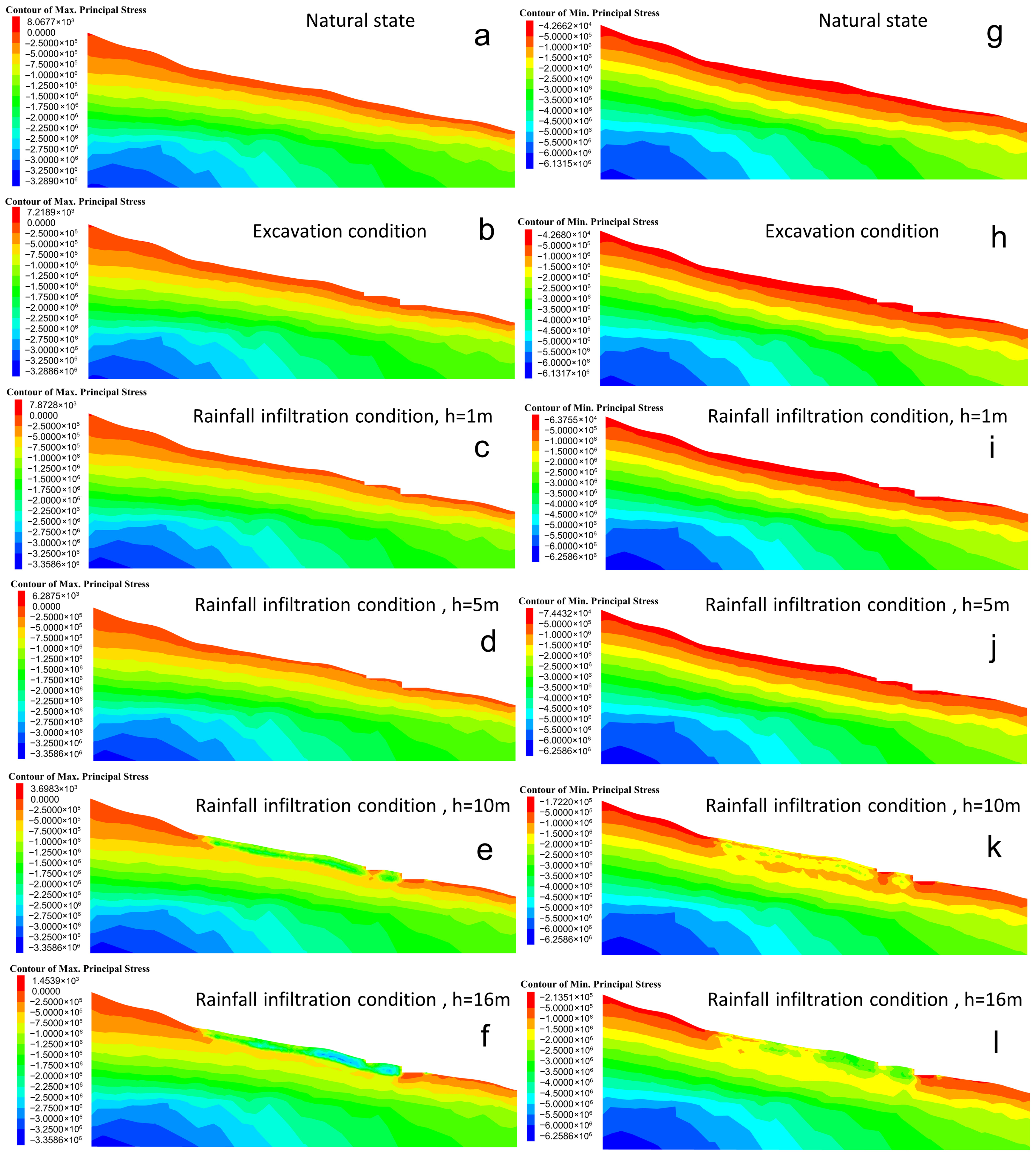
Under the initial (natural) state, the stress field governed solely by gravitational forces exhibited the typical self-weight equilibrium pattern. Near the slope surface, the maximum principal stress (σ1) aligned sub-parallel to the free face, locally manifesting as tensile stress (peak value: +0.0081 MPa). The minimum principal stress (σ3) was oriented perpendicular to the slope surface. Deeper within the slope, σ1 gradually rotated towards the vertical direction, while σ3 became predominantly horizontal—both were compressive. Maximum compressive stresses reached magnitudes of −3.2890 MPa (σ1) and −6.1315 MPa (σ3). The layered, uniform distribution of stress contours (Figure 6a,g) confirmed agreement with semi-infinite space theory, validating the model setup accuracy.
Post-excavation, surficial principal stresses remained compression-dominated with distribution patterns consistent with the initial state. The localized surface tensile σ1 marginally decreased to +0.0072 MPa. Internal compressive stresses were largely unaffected (σ1: −3.2886 MPa; σ3: −6.1317 MPa). Stress contour smoothness and layering persisted (Figure 6b,h), demonstrating the minor contribution of excavation to overall stress redistribution.
During rainfall simulation, coupled gravitational–seepage interactions induced significant alterations: tensile σ1 near the surface progressively diminished with infiltration depth (Figure 6c,d,h,i). Crucially, with infiltration depths exceeding 5 m (Scenarios 3–5), an abrupt stress transition occurred in the highly permeable colluvium zone: σ1 reversed from weakly tensile (−0.006 MPa representing a very small effective tension) to strong compression (−1.0 MPa) (Figure 6e,f). Concurrently, σ3 compressive magnitude surged from −0.07 MPa to −1.8 MPa (Figure 6k,l). The initially uniform stress contours became extensively disrupted, confirming the substantive modification of stress distribution within the colluvium by the evolving seepage field.

4.5.2. Evolution of Displacement Field Characteristics

Displacement field evolution, based on simulation results (Figure 7), also exhibits a distinct three-stage response:
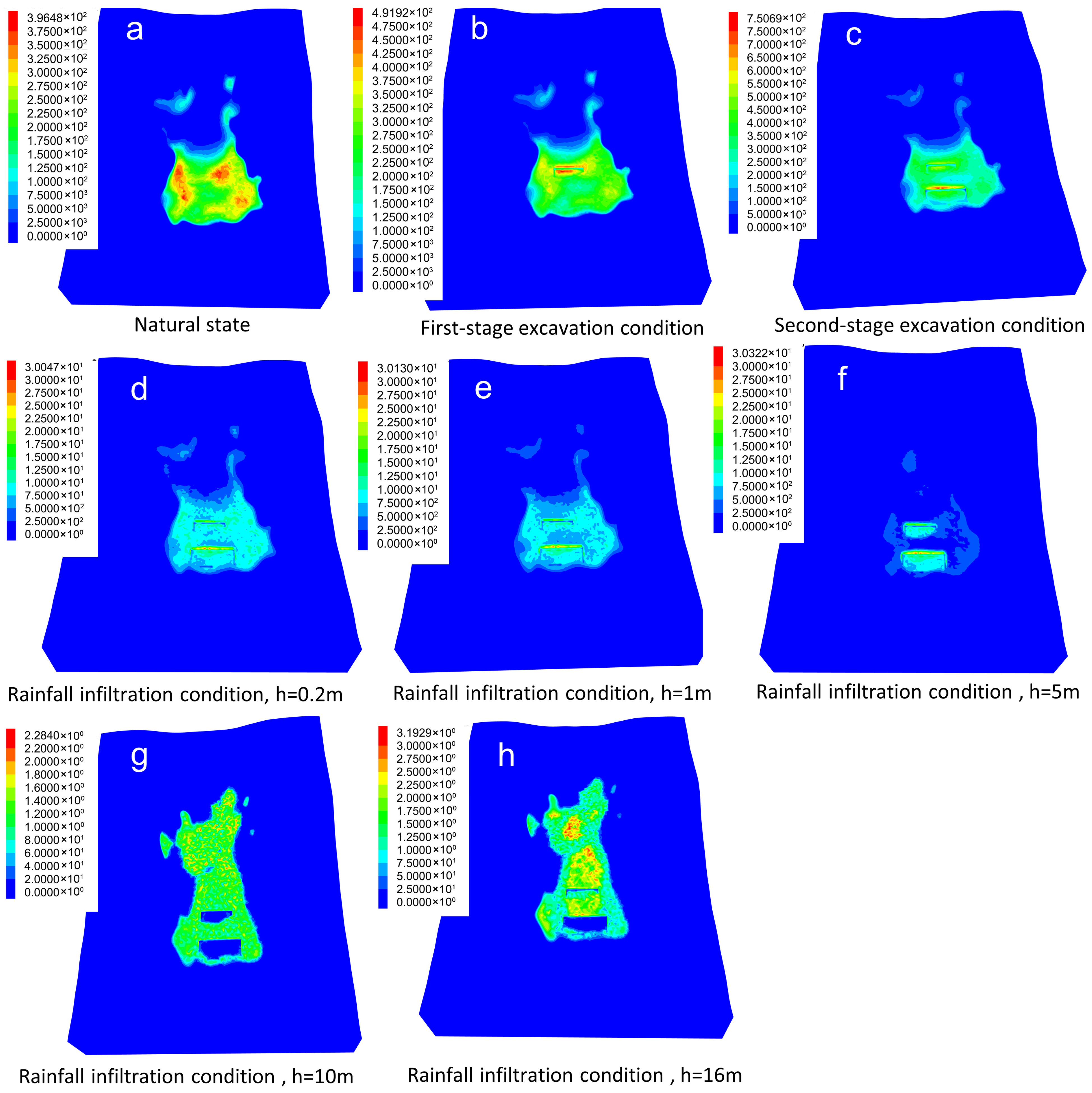
In the initial state (natural scenario), the maximum total displacement was 0.0396 m. Deformation was concentrated predominantly in the mid-lower section of the sliding mass. Profile 2-2′ revealed a maximum displacement of 0.02634 m located within the shallow, upper-middle portion of the sliding mass (Figure 7a).
During excavation stages, following the first-stage excavation, displacements localized near the trailing edge of the cut, reaching 0.0492 m (an increase of 0.0052 m from baseline). Displacement magnitudes decayed radially inward from the surface (Figure 7b). After the second-stage excavation, deformation expanded towards the berm backslopes and adjacent areas, with the maximum displacement substantially increasing to 0.0751 m. This peak value was located near the toe of the backslope behind the second bench, representing an increase of 0.0359 m compared to the first-stage excavation (Figure 7c). This confirms the localized disturbance effect induced by excavation.
Under rainfall infiltration scenarios, displacement evolution displayed sensitivity to infiltration depth (h). At h = 0.2 m, the maximum total displacement reached 0.255 m (Figure 7), concentrated in the mid-lower section and toe of the sliding mass (Figure 7d). Increasing h to 1 m resulted in a marginal increase to 0.256 m with a similar distribution pattern (Figure 7e). While h = 5 m yielded a slight further rise to 0.258 m, displacement remained focused in the toe region (Figure 7f). However, a critical transition occurred for h > 5 m: At h = 10 m, displacement surged dramatically to 2.202 m. The displacement concentration shifted significantly: deformation propagated from the mid-rear section towards the mid-lower zone of the sliding mass (Figure 7g). Finally, at h = 16 m (full saturation depth), total displacement peaked at 2.719 m (Figure 7h). Full-thickness mobilization occurred, forming a strong central deformation band within the sliding mass.

4.5.3. Evolution of Plastic Zone Characteristics

Plastic zone evolution, systematically analyzed via Figure 8, reveals a continuous three-stage response:
Under the initial state, the sliding mass exhibited four discrete yield modes: “shear-p tension-p” (historically sheared and tensile-yielded, presently stable), “shear-n shear-p” (actively undergoing shear failure), “shear-p” (historically shear-yielded, stable), and “tension-p” (historically tensile-yielded, stable). Profile 2-2′ demonstrated localized, nonconnected “shear-n shear-p” zones within the mid-lower sliding mass (Figure 8a).
During the excavation phase, the predominant yield mode transitioned to “shear-p” in the mid-lower slope after the first-stage excavation (Figure 8b). The second-stage excavation activated the development and downward propagation of “shear-n shear-p” zones within the excavated area, while the mid-lower section of the main profile maintained its “shear-n shear-p” configuration (Figure 8c).
Rainfall infiltration induced a depth-dependent plastic response with a critical failure mechanism transition: For infiltration depths h ≤ 5 m (quantitative change phase), the “shear-p” domain progressively expanded as infiltration deepened. At h = 0.2 m (Figure 8d), “tension-p” zones inhabited the upper rear slope, while “shear-p” covered nearly the entire body. By h = 1 m (Figure 8e), the “shear-p” domain further enlarged, shrinking “shear-p tension-p” areas, with compound “shear-n shear-p tension-p” yielding emerging near the rear of the second-stage excavation. At h = 5 m (Figure 8f), nonconnected “shear-n shear-p” zones persisted in the upper-middle and mid-lower profile. Critically, once infiltration depth surpassed the 5 m threshold (qualitative change phase), the plastic zones underwent an abrupt transition from localized shear fractures to pervasive connectivity. Under h = 10 m (Figure 8g), “tension-p” zones propagated peripherally while “shear-p tension-p” diffused globally. At h = 16 m (Figure 8h), fractures progressively expanded, gradually interconnected, and ultimately coalesced into a systematic failure network dominated by pervasively distributed “shear-p tension-p” and fully penetrated “shear-n shear-p” zones. This marks the integration of shear slip surfaces and the onset of global structural instability [68].

4.5.4. Pore Water Pressure Response Characteristics

Pore water pressure contours from profile 2-2′ (Figure 9) demonstrate a domain-wide increasing trend with greater infiltration depths. At h ≤ 5 m (Figure 9a–c), pressures concentrated within the mid-lower sliding mass (h = 0.2 m: 0.107 MPa; h = 1 m: 0.109 MPa; h = 5 m: 0.152 MPa), gradually propagating upwards. Magnitude changes during this phase were marginal (0.107 → 0.152 MPa), indicating predominantly localized stability impacts from shallow infiltration. When h > 5 m (Figure 9d–e), pore pressures saturated the entire slope domain, magnitudes surging dramatically (h = 10 m: 2.715 MPa; h = 16 m: 3.235 MPa). The translational leap in spatial distribution and failure magnitude—manifested as transitions from localized clusters toward extensive coverage, and from progressive accumulation to catastrophic escalation—exhibits demonstrable synergy with synchronous displacement accelerations (2.202 m at h = 10 m → 2.719 m at h = 16 m) and plastic zone coalescence. This integrated response substantiates that pore-network-controlled hydro-mechanical coupling becomes the predominant regulator of slope integrity when infiltration thresholds surpass 5 m [69].
In synthesis, under sustained intense rainfall, the highly permeable gravelly soil and pre-existing surficial fractures facilitated progressive deep infiltration and downslope groundwater flow toward the slope toe. Crucially, mid-lower slope excavations altered original surface/subsurface drainage pathways, impeding rapid rainfall discharge. Consequently, water accumulated at the toe, propagating upwards and generating elevated pore pressures. Simultaneously, saturation of the colluvium imposed significant hydraulic loading. Acting in concert—hydraulic loading, seepage forces, and strength softening—these mechanisms degraded shear resistance along the potential failure surface, culminating in progressive connection. Ultimate shearing of this fully developed surface triggered landslide reactivation.

5. Discussion

This study employs high-fidelity fluid–solid coupling numerical simulations to quantitatively unveil the complex synergistic triggering mechanisms behind the reactivation of the Longdongpo ancient landslide. Our findings demonstrate that prolonged groundwater activity progressively weakens the slip zone (bedrock–overburden interface), forming an essential material foundation for reactivation. The colluvial silty clay within the landslide body exhibits high porosity (n = 0.4) and permeability (k = 3.5 × 10⁻⁵ m/s), while rubble-rich red clay blocks at the leading edge create natural hydraulic barriers (Section 1). This hydraulic configuration—pervious upper layers overlying an impervious basal zone—impedes groundwater discharge from the rear scarp, generating sustained excess pore water pressure (locally reaching 0.15 MPa under natural conditions, Figure 9a) that chronically saturates and softens the soil–rock interface. Concurrently, the topographic trough formed by the arcuate rear scarp and flanking gullies constitutes an efficient catchment system, maintaining continuous saturation along the upper slip surface. This hydrogeological system persists temporally and spatially—notably continuing post the 2011 partial reactivation—aligning with documented geological time-dependent degradation phenomena in analogous paleolandslides [70].
Crucially, anthropogenic slope excavation acts as a catalytic agent in this system. Although mid-lower slope cuts (Case 2) did not directly trigger global instability, they critically perturbed stress distribution and altered natural seepage paths, thereby elevating slope sensitivity to subsequent disturbances. This stress redistribution and toe support reduction caused by downslope material removal parallels numerous documented excavation-induced landslide cases [71,72]. Our simulations quantitatively demonstrate how such perturbations precondition the slope: creating poorly drained zones for future rainfall infiltration and accelerating subsequent plastic deformation development.
The decisive triggering mechanism derives from deep rainfall infiltration during intense precipitation (fluid–solid coupling condition). Site-specific simulations establish 5 m (h = 5 m) as the critical infiltration depth for global failure. Results confirm limited pore pressure increase (<0.152 MPa) and gradual deformation progression below this threshold, maintaining quasi-stable conditions. However, when infiltration exceeds 5 m (h = 10 m, h =16 m), high-permeability colluvium (k = 3.5 × 10⁻⁵ m/s) and connected fractures enable rapid deep saturation, generating >2.7 MPa excess pore pressure at hydraulic bottlenecks. This elevated pressure drives failure through dual pathways which (1) substantially reduces effective normal stress and shear strength along the slip surface [73], and (2) increases downslope driving forces via saturated soil weight amplification [74]. The synergistic effect triggers abrupt displacement surges (>2.2 m) and full connectivity of plastic zones (shear-n/shear-p), forming a throughgoing failure surface. This quantitative framework advances understanding of deep-triggered failures beyond conventional shallow landslide models.
Thus, Longdongpo’s reactivation follows a three-stage cascade mechanism: long-term hydrogeological weakening → anthropogenic disturbance → deep rainfall infiltration exceeding critical depth (5 m). Our simulations pioneer the complete reconstruction of this process chain, revealing that infiltration depths >5 m cause dramatic saturation expansion near the slip surface, enabling full pore pressure transmission to shear interfaces that abruptly reduce strength—ultimately triggering displacements >2.2 m and plastic zone coalescence. While this 5 m threshold is site-specific, it establishes a quantitative methodology for optimizing monitoring strategies and establishing rainfall warning criteria in regional colluvial paleolandslides. Future studies should be complemented by deploying real-time monitoring systems with deep inclinometers and piezometers, along with conducting cyclic saturation-softening tests on slip zone soils and unsaturated–saturated transient seepage simulations, to refine the theoretical framework and application reliability of this research (Table 2).

6. Conclusions

(1)
Longdongpo constitutes a reactivated large-scale, mid-thick colluvial paleolandslide exhibiting an elongated tongue morphology (primary sliding direction: 92°, longitudinal length 650 m, average thickness 12 m, volume ~160 × 104 m3). The sliding mass consists of colluvial silty clay with rock fragments (gravel content 20–35%), with the basal slip zone demarcating the Quaternary–Silurian intensely weathered mudstone interface. Its destabilization resulted from compounding factors: unfavorable geotechnical configurations (fundamental predisposition), anthropogenic excavation (contributing factor), and sustained rainfall (triggering mechanism), with evolutionary stages comprising rear-scarp superficial creep—Stage (I); ore excavation with associated mid-slope creep progression—Stage (II); lip surface coalescence–global reactivation failure—Stage (III).
(2)
FLAC3D fluid–solid coupled simulations quantitatively establish reactivation as a chained process: “long-term groundwater weakening → excavation-induced hydrologic disruption → critical-depth rainfall triggering”. (a) Long-Term Weakening: Groundwater persistently softens the slip zone, degrading its shear resistance. (b) Excavation Disruption: Critically alters natural drainage pathways, impeding slope drainage (core action). (c) Critical Rainfall Threshold: The 5 m critical infiltration depth was determined based on the gravelly soil’s permeability (k = 3.5 × 10⁻⁵ m/s as measured) and the slip zone’s hydraulic-structural configuration. At h > 5 m, rapid deep infiltration (controlled by gravelly soil permeability and fractures) accumulates in excavation-disrupted drainage zones. This induces pore pressure surge (>2.7 MPa), water-weight loading, sharp reduction in slip zone effective strength, and increased driving force. These jointly provoke plastic zone connection (pervasive “shear-n shear-p” yielding) and catastrophic displacement acceleration (>2.2 m), culminating in global failure.

Author Contributions

J.Z. and J.C. wrote the manuscript. Y.Q. and J.C. contributed to the conception of this study. K.L. provided funding for this study. X.X. and W.G. performed the data analysis. J.Z. was involved in validation, investigation, and data curation; J.C. also took part in conceptualization, methodology, supervision; Y.Q. contributed to conceptualization, methodology, writing—review and editing, project administration; X.X. was responsible for software, formal analysis, investigation; W.G. was involved in validation and formal analysis; K.L. handled resources, supervision, and funding acquisition. All authors have read and agreed to the published version of the manuscript.

Funding

This work was supported by the Science and Technology Program of the Science and Technology Department of Guizhou Province (Grant Nos. 2021-512).

Data Availability Statement

The original contributions presented in the study are included in the article and further inquiries can be directed to the corresponding author.

Conflicts of Interest

Author Jinhong Chen was employed by Guizhou Coal Design and Geological Engineering Co., Ltd. The remaining authors declare that the research was conducted in the absence of any commercial or financial relationships that could be construed as a potential conflict of interest.

References

  1. Jiang, S. Study of landslide geological hazard prediction method based on probability migration. Nat. Hazards 2021, 108, 1753–1762. [Google Scholar] [CrossRef]
  2. Sassa, S. Landslides and Tsunamis: Multi-Geohazards. Landslides 2023, 20, 1335–1341. [Google Scholar] [CrossRef]
  3. Tan, Q.; Bai, M.; Zhou, P.; Hu, J.; Qin, X. RETRACTED: Geological hazard risk assessment of line landslide based on remotely sensed data and GIS. Measurement 2021, 169, 108370. [Google Scholar] [CrossRef]
  4. Su, Y.; Rong, G.; Ma, Y.; Chi, J.; Liu, X.; Zhang, J.; Li, T. Hazard Assessment of Earthquake Disaster Chains Based on Deep Learning—A Case Study of Mao County, Sichuan Province. Front. Earth Sci. 2022, 9, 683903. [Google Scholar] [CrossRef]
  5. Yin, D.; Zhang, B.; Yan, J.; Luo, Y.; Zhou, T.; Qin, J. CoWNet: A correlation weighted network for geological hazard detection. Knowl.-Based Syst. 2023, 275, 110684. [Google Scholar] [CrossRef]
  6. Zhong, J.; Li, Q.; Zhang, J.; Luo, P.; Zhu, W. Risk Assessment of Geological Landslide Hazards Using D-InSAR and Remote Sensing. Remote. Sens. 2024, 16, 345. [Google Scholar] [CrossRef]
  7. Jia, Y.; Jia, S.; Pang, R. Measurement and impact analysis of social vulnerability to geological disasters in Guizhou Province, China. Sci. Rep. 2024, 14, 25098. [Google Scholar] [CrossRef]
  8. Zhu, Q.; Yuan, H.; Wang, L.; Zeng, C.; Bashir, M.; Vasudevan, N.; Sethupathi, S. A Study on Risk Assessment of Geological Disasters in Pingba District of Guizhou Province Based on GIS. In Proceedings of the E3S Web of Conferences, 2023 9th International Conference on Energy Materials and Environment Engineering (ICEMEE 2023), Guilin, China, 25–27 August 2023. [Google Scholar] [CrossRef]
  9. Zou, F.; Che, E.; Long, M. Quantitative assessment of geological hazard risk with different hazard indexes in mountainous areas. J. Clean. Prod. 2023, 413, 137467. [Google Scholar] [CrossRef]
  10. Chen, J.; Xu, C. Geological Hazards and Risk Management. Sustainability 2024, 16, 3286. [Google Scholar] [CrossRef]
  11. Wu, Z.; Ye, R.; Yang, S.; Wen, T.; Huang, J.; Chen, Y. Study on Early Identification of Rainfall-Induced Accumulation Landslide Hazards in the Three Gorges Reservoir Area. Remote. Sens. 2024, 16, 1669. [Google Scholar] [CrossRef]
  12. Yang, X.; Diao, X.; Zhou, T.; Hu, F.; Wang, S. Study on the Stability of Accumulated Layer Landslide under the Coupling Action of Earthquake and Rainfall. KSCE J. Civ. Eng. 2022, 27, 98–108. [Google Scholar] [CrossRef]
  13. Zhou, C.; Ai, D.; Huang, W.; Xu, H.; Ma, L.; Chen, L.; Wang, L. Emergency Survey and Stability Analysis of a Rainfall-Induced Soil-Rock Mixture Landslide at Chongqing City, China. Front. Earth Sci. 2021, 9, 774200. [Google Scholar] [CrossRef]
  14. Li, C.; Criss, R.E.; Fu, Z.; Long, J.; Tan, Q. Evolution characteristics and displacement forecasting model of landslides with stair-step sliding surface along the Xiangxi River, three Gorges Reservoir region, China. Eng. Geol. 2021, 283, 105961. [Google Scholar] [CrossRef]
  15. Zhang, Z.; Wang, T. Failure modes of weak interlayers with different dip angles in red mudstone strata, Northwest China. Bull. Eng. Geol. Environ. 2023, 82, 156. [Google Scholar] [CrossRef]
  16. Zhou, J.; Zhao, F.; Zhu, Y.; Dong, W.; He, Z.; Wang, P. Dynamic Behavior and Constitutive Relationship of Mudstone Slip Zone of Landslide with Weak Interlayer. Shock. Vib. 2021, 2021, 3330127. [Google Scholar] [CrossRef]
  17. Li, X.; Zhang, J.; Tian, Y.; Zhao, Y. Assessing hazards of ancient landslide clusters in the Lancang river basin using multi-temporal remote sensing: A case study of Chaya county. Prog. Phys. Geogr. Earth Environ. 2025, 49, 44–62. [Google Scholar] [CrossRef]
  18. Wu, R.; Zhang, Y.; Guo, C.; Yang, Z.; Ren, S.; Tong, B. Reactivation characteristics and dynamic hazard prediction of an ancient landslide in the east margin of Tibetan Plateau. Environ. Earth Sci. 2018, 77, 573. [Google Scholar] [CrossRef]
  19. Yang, Z.; Wu, T.; E, C.; Xie, X.; Tan, L.; Jiang, X. A quantitative enhanced assessment for ancient landslide reactivation risk considering cross-time scale joint response mechanism. Front. Earth Sci. 2023, 10, 974442. [Google Scholar] [CrossRef]
  20. Dai, L.; Jia, C.; Chen, L.; Zhang, Q.; Chen, W. Development Characteristics and Reactivation Mechanism of a Large-Scale Ancient Landslide in Reservoir Area. Appl. Sci. 2024, 14, 3107. [Google Scholar] [CrossRef]
  21. Guo, C.; Wu, R.; Zhang, Y.; Yan, Y.; Yang, Z.; Zhang, Y.; Wu, Z.; Yuan, H.; Liu, J. Investigation on the development characteristics and reactivation mechanism of the Zhama ancient landslide in Batang County, Eastern Tibetan Plateau, China. Environ. Earth Sci. 2023, 83, 39. [Google Scholar] [CrossRef]
  22. Wang, R.; Zhang, K.; Ning, Y.; Xu, W.; Wang, W.; Qin, J.; Chen, X. Reactivation of Ancient Landslide Deposits: Geological Characteristics and Deformation Mechanism. Adv. Civ. Eng. 2021, 2021, 6614180. [Google Scholar] [CrossRef]
  23. Guo, C.; Zhang, Y.; Yuan, H.; Liu, D.; Yan, Y.; Hua, S.; Ren, S. Study of an ancient landslide reactivation mechanism based on centrifuge model testing: An example of the Jiangdingya ancient landslide reactivation in 2018, Gansu Province, China. Landslides 2022, 20, 127–141. [Google Scholar] [CrossRef]
  24. Huang, X.; Wang, L.; Ye, R.; Yi, W.; Huang, H.; Guo, F.; Huang, G. Study on deformation characteristics and mechanism of reactivated ancient landslides induced by engineering excavation and rainfall in Three Gorges Reservoir area. Nat. Hazards 2021, 110, 1621–1647. [Google Scholar] [CrossRef]
  25. Pando, L.; Díaz-Díaz, L.M.; Arias, D.; Castañón, C.; López-Fernández, C. A large palaeo-landslide reactivated by high-speed railway construction works (northern Spain). Q. J. Eng. Geol. Hydrogeol. 2019, 53, 290–297. [Google Scholar] [CrossRef]
  26. Deng, H.; Zhang, W.; Wang, L.; Kang, Y.; Wang, Y.; Wang, L.; Zou, Y. Deformation Mechanism of Large--Scale Ancient Reservoir Landslides Driven by the Monitoring Data and Numerical Simulation. Geol. J. 2025, 60, 1170–1183. [Google Scholar] [CrossRef]
  27. Deng, L.; Yuan, H.; Chen, J.; Zhang, M.; Su, G.; Zhou, Y.; Chen, Y. Experimental investigation and field application of acoustic emission array for landslide monitoring. Landslides 2023, 21, 71–81. [Google Scholar] [CrossRef]
  28. Lollino, P.; Giordan, D.; Allasia, P. Assessment of the behavior of an active earth-slide by means of calibration between numerical analysis and field monitoring. Bull. Eng. Geol. Environ. 2016, 76, 421–435. [Google Scholar] [CrossRef]
  29. Wang, L.; Zhang, K.; Chen, Y.; Wang, S.; Tian, D.; Li, X.; He, Y. Progressive deformation mechanism of colluvial landslides induced by rainfall: Insights from long-term field monitoring and numerical study. Landslides 2024, 21, 3069–3086. [Google Scholar] [CrossRef]
  30. Jiang, Z.; Wang, H.; Xie, W. Deformation mechanism of deposit landslide induced by fluctuations of reservoir water level based on physical model tests. Environ. Earth Sci. 2021, 80, 410. [Google Scholar] [CrossRef]
  31. Li, Z.; Wang, D.; Fan, X.; Jiang, L.; Li, L.; Zhang, Y. Multi-stage sliding of the giant Mogangling paleo-landslide on the East Margin of the Tibetan Plateau revealed by integrated engineering geophysical methods. Landslides 2025, 22, 3117–3132. [Google Scholar] [CrossRef]
  32. Yang, H.; Tang, M.; Xiao, X.; Cai, G.; Wei, Y.; Li, S.; Li, H.; Xie, J. Physical Model Test of Deformation Self-Adaptive Mechanism of Landslide Mass. Water 2024, 16, 1720. [Google Scholar] [CrossRef]
  33. Chen, S.; Xu, W.; Zhang, G.; Wang, R.; Yan, L.; Zhang, H.; Wang, H. Numerical simulation of potential impulse waves generated by the Mogu rock landslide at varying water levels in the Lianghekou Reservoir, China. Landslides 2024, 21, 2289–2305. [Google Scholar] [CrossRef]
  34. Yan, J.; Chen, J.; Zhou, F.; Li, Y.; Zhang, Y.; Gu, F.; Zhang, Y.; Li, Y.; Li, Z.; Bao, Y.; et al. Numerical simulation of the Rongcharong paleolandslide river-blocking event: Implication for the longevity of the landslide dam. Landslides 2022, 19, 1339–1356. [Google Scholar] [CrossRef]
  35. Liu, K.; Liu, H. Simulation of the earthquake-induced soil-rock mixed accumulation body sliding movement using discrete–continuous coupled approach. Nat. Hazards 2022, 114, 2087–2108. [Google Scholar] [CrossRef]
  36. Quecedo, M.; Pastor, M.; Herreros, M.I.; Merodo, J.A.F. Numerical modelling of the propagation of fast landslides using the finite element method. Int. J. Numer. Methods Eng. 2004, 59, 755–794. [Google Scholar] [CrossRef]
  37. Li, X.; Wu, R.; Han, B.; Song, D.; Wu, Z.; Zhao, W.; Zou, Q. Evolution Process of Ancient Landslide Reactivation under the Action of Rainfall: Insights from Model Tests. Water 2024, 16, 583. [Google Scholar] [CrossRef]
  38. Liu, G.; Tong, F.-G.; Zhao, Y.-T.; Tian, B. A force transfer mechanism for triggering landslides during rainfall infiltration. J. Mt. Sci. 2018, 15, 2480–2491. [Google Scholar] [CrossRef]
  39. Song, Y.; Lv, T.; Liu, H.; Huang, D.; Gu, D. Failure mechanism of the slope containing coarse particle enrichment zones located at the soil–rock interface under the heavy rainfall. Environ. Earth Sci. 2024, 83, 302. [Google Scholar] [CrossRef]
  40. Lian, J.; Ding, X.-M.; Zhang, L. Shaking table test on seismic response of an accumulation landslide reinforced by pile-plate retaining wall based on the time-frequency analysis method. J. Cent. South Univ. 2023, 30, 1710–1721. [Google Scholar] [CrossRef]
  41. Praet, N.; Moernaut, J.; Van Daele, M.; Boes, E.; Haeussler, P.J.; Strupler, M.; Schmidt, S.; Loso, M.G.; De Batist, M. Paleoseismic potential of sublacustrine landslide records in a high-seismicity setting (south-central Alaska). Mar. Geol. 2017, 384, 103–119. [Google Scholar] [CrossRef]
  42. Yan, Y.; Cui, Y.; Tian, X.; Hu, S.; Guo, J.; Wang, Z.; Yin, S.; Liao, L. Seismic signal recognition and interpretation of the 2019 “7.23” Shuicheng landslide by seismogram stations. Landslides 2020, 17, 1191–1206. [Google Scholar] [CrossRef]
  43. Dai, Z.; Zhang, Y.; Zhang, C.; Luo, J.; Yao, W. Interpreting the Influence of Reservoir Water Level Fluctuation on the Seepage and Stability of an Ancient Landslide in the Three Gorges Reservoir Area: A Case Study of the Outang Landslide. Geotech. Geol. Eng. 2022, 40, 4551–4561. [Google Scholar] [CrossRef]
  44. Wang, R.; Wan, J.; Cheng, R.; Wang, Y.; Wang, Z. Physical and Numerical Simulation of the Mechanism Underpinning Accumulation Layer Deformation, Instability, and Movement Caused by Changing Reservoir Water Levels. Water 2023, 15, 1289. [Google Scholar] [CrossRef]
  45. Chen, G.; Teng, P.; Duan, H.; Zhang, G.; Li, T. Characteristics of Collapse Accumulation Body in Roadway and Numerical Simulation of Rescue Channel Excavation. Geotech. Geol. Eng. 2021, 40, 1121–1133. [Google Scholar] [CrossRef]
  46. Wu, Y.; Xue, D.; Chen, K.; Dai, C.; Hang, Z.; Wu, Z.; Zhang, S. Failure mechanism and early warning of an excavation-induced soil landslide. Front. Earth Sci. 2024, 12, 1410011. [Google Scholar] [CrossRef]
  47. Yang, X.; Chen, Y. Characteristics and mechanism of landslides on highway landfill along Xiaolangdi Reservoir of the Yellow River: A case study. Nat. Hazards 2024, 120, 10321–10343. [Google Scholar] [CrossRef]
  48. Béjean-Maillard, O.; Bertrand, C.; Malet, J.-P.; Cinkus, G.; Nevers, P.; Ducasse, J.; Bertolo, D.; Thuegaz, P. Hydrogeological forecasting of deep-seated landslides dynamics: Structure and sensitivity of tank models. Landslides 2025, 22, 2199–2217. [Google Scholar] [CrossRef]
  49. Shao, W.; Nie, W.; Ni, J. Research on Landslide Hydrology and Hydrogeological Disaster Monitoring. Water 2023, 15, 1910. [Google Scholar] [CrossRef]
  50. Thirard, G.; Grandjean, G.; Thiery, Y.; Maquaire, O.; François, B.; Lissak, C.; Costa, S. Hydrogeological assessment of a deep-seated coastal landslide based on a multi-disciplinary approach. Geomorphology 2020, 371, 107440. [Google Scholar] [CrossRef]
  51. Cui, Y.; Yang, W.; Xu, C.; Wu, S. Distribution of ancient landslides and landslide hazard assessment in the Western Himalayan Syntaxis area. Front. Earth Sci. 2023, 11, 1135018. [Google Scholar] [CrossRef]
  52. Rasanen, R.A.; Maurer, B.W. Probabilistic seismic source inversion from regional landslide evidence. Landslides 2021, 19, 407–419. [Google Scholar] [CrossRef]
  53. Chen, Y.; He, X.; Xu, C.; Huang, Y.; Zhang, P.; Luo, Z.; Zhan, T. Development Characteristics and Causes of a Fatal Landslide Occurred in Shuicheng, Guizhou Province, China. ISPRS Int. J. Geo-Inf. 2022, 11, 119. [Google Scholar] [CrossRef]
  54. Chandrasekaran, S.S.; Kesavaram, R.; Manickam, S.; Ganapathy, G.P.; Ray, A.; Nivethiha, P.; Thamizhmaran, A. Failure mechanism of the rainfall-induced landslide in December 2024 in Tiruvannamalai, India: Insights from the field, geotechnical, and remote sensing observations. In Landslides; Springer: Berlin/Heidelberg, Germany, 2025; pp. 1–22. [Google Scholar] [CrossRef]
  55. Hamrouni, F.; Trabelsi, H.; Jamei, M.; Olivella, S. Numerical analysis of landslides caused by rainfall in a reduced physical slope model. Eur. J. Environ. Civ. Eng. 2021, 25, 1449–1470. [Google Scholar] [CrossRef]
  56. Chen, W.; Liu, B.; Wu, Q.; Liu, J.; Ren, Z.; Wang, Q.; Liu, Z.; Peng, W.; Zhou, Y.; Wang, Y.; et al. Experimental study on effective stress coefficient of sandstone based on Mohr–Coulomb criterion under hydraulic-mechanical coupling. Sci. Rep. 2025, 15, 17437. [Google Scholar] [CrossRef] [PubMed]
  57. Cheng, B.; Xu, T.; Tang, J. Reservoir Brittleness Prediction Method Based on the Mohr–Coulomb Failure Criterion and Effective In Situ Stress Principle. Rock Mech. Rock Eng. 2022, 55, 5933–5951. [Google Scholar] [CrossRef]
  58. Li, W.; Zhang, D.; Li, M. Failure Criteria of Gas-Infiltrated Sandy Shale Based on the Effective Stress Principle. Energies 2016, 9, 972. [Google Scholar] [CrossRef]
  59. Yan, J.; Zou, Z.; Mu, R.; Hu, X.; Zhang, J.; Zhang, W.; Su, A.; Wang, J.; Luo, T. Evaluating the stability of Outang landslide in the Three Gorges Reservoir area considering the mechanical behavior with large deformation of the slip zone. Nat. Hazards 2022, 112, 2523–2547. [Google Scholar] [CrossRef]
  60. Yu, Y.; Zhang, Z.; Dai, F.; Bai, S. A New Shear Strength Model with Structural Damage for Red Clay in the Qinghai-Tibetan Plateau. Appl. Sci. 2024, 14, 3169. [Google Scholar] [CrossRef]
  61. Zou, Z.; Luo, T.; Zhang, S.; Duan, H.; Li, S.; Wang, J.; Deng, Y.; Wang, J. A novel method to evaluate the time-dependent stability of reservoir landslides: Exemplified by Outang landslide in the Three Gorges Reservoir. Landslides 2023, 20, 1731–1746. [Google Scholar] [CrossRef]
  62. Liang, C.; Zhao, J.; Wang, T. Formation and evolution mechanism of a catastrophic mudflow in a complex disaster-prone environment in a strong earthquake-disturbance region. Environ. Earth Sci. 2024, 83, 199. [Google Scholar] [CrossRef]
  63. Song, K.; Lu, G.; Zhang, G.; Liu, Y. Influence of uncertainty in the initial groundwater table on long-term stability of reservoir landslides. Bull. Eng. Geol. Environ. 2016, 76, 901–908. [Google Scholar] [CrossRef]
  64. Sun, L.; Zhao, Y.; Li, C.; Sun, Y.; Gao, S. Study on water softening characteristics and multi-stage sliding zone reactivation mechanism of old clay landslides in the Three Gorges Reservoir area subjected to groundwater. Bull. Eng. Geol. Environ. 2024, 83, 443. [Google Scholar] [CrossRef]
  65. Ji, Y.-Q.; Su, S.-R.; Simoni, A.; Huang, Q.-B. Giant paleo-landslides in the upper reaches of the Yellow River: Spatio–temporal distribution, and possible controlling factors. J. Palaeogeogr. 2025, 14, 391–412. [Google Scholar] [CrossRef]
  66. Zhang, Y.; Chen, J.; Zhou, F.; Bao, Y.; Yan, J.; Zhang, Y.; Li, Y.; Gu, F.; Wang, Q. Combined numerical investigation of the Gangda paleolandslide runout and associated dam breach flood propagation in the upper Jinsha River, SE Tibetan Plateau. Landslides 2022, 19, 941–962. [Google Scholar] [CrossRef]
  67. Panda, S.D.; Kumar, S.; Pradhan, S.P.; Singh, J.; Kralia, A.; Thakur, M. Effect of groundwater table fluctuation on slope instability: A comprehensive 3D simulation approach for Kotropi landslide, India. Landslides 2023, 20, 663–682. [Google Scholar] [CrossRef]
  68. Zhu, H.; Ju, Y.; Lu, Y.; Yang, M.; Feng, H.; Qiao, P.; Qi, Y. Natural evidence of organic nanostructure transformation of shale during bedding-parallel slip. GSA Bull. 2025, 137, 2719–2746. [Google Scholar] [CrossRef]
  69. Zhu, H.; Lu, Y.; Pan, Y.; Qiao, P.; Raza, A.; Liu, W. Nanoscale mineralogy and organic structure characterization of shales: Insights via AFM-IR spectroscopy. Adv. Geo-Energy Res. 2024, 13, 231–236. [Google Scholar] [CrossRef]
  70. Liu, H.-X.; Xu, Q.; Qiu, T.; Li, J. Investigation of multi-annual groundwater response to rainfall in a deep-seated bedrock landslide: The case of the Kualiangzi landslide, China. Nat. Hazards 2023, 120, 2749–2775. [Google Scholar] [CrossRef]
  71. Despojo, J.; Brook, M.S.; Alama, D.; Cook, M.E.; Cave, M. Landslide preparation by forestry activity in a region of high erosion rates: Waingake Landslide, northeast New Zealand. New Zealand J. Geol. Geophys. 2025, 68, 1015–1030. [Google Scholar] [CrossRef]
  72. Huang, X.-h.; Yi, W.; Gong, C.; Huang, H.-f.; Yu, Q. Reactivation and deformation mechanism of ancient landslides by excavation. Chin. J. Geotech. Eng. 2020, 42, 1276–1285. [Google Scholar] [CrossRef]
  73. Zhou, Z.; Shen, J.; Tang, S.; Duan, W.; Wang, J.; Yang, R.; Zheng, S.; Guo, F. Analysis of Weakening Law and Stability of Sliding Zone Soil in Thrust-Load-Induced Accumulation Landslides Triggered by Rainfall Infiltration. Water 2021, 13, 466. [Google Scholar] [CrossRef]
  74. Ren, Y.; Chen, X.; Shang, Y. Study on the influence of rainfall infiltration on the stability of dump slope. Desalination Water Treat. 2024, 319, 100492. [Google Scholar] [CrossRef]
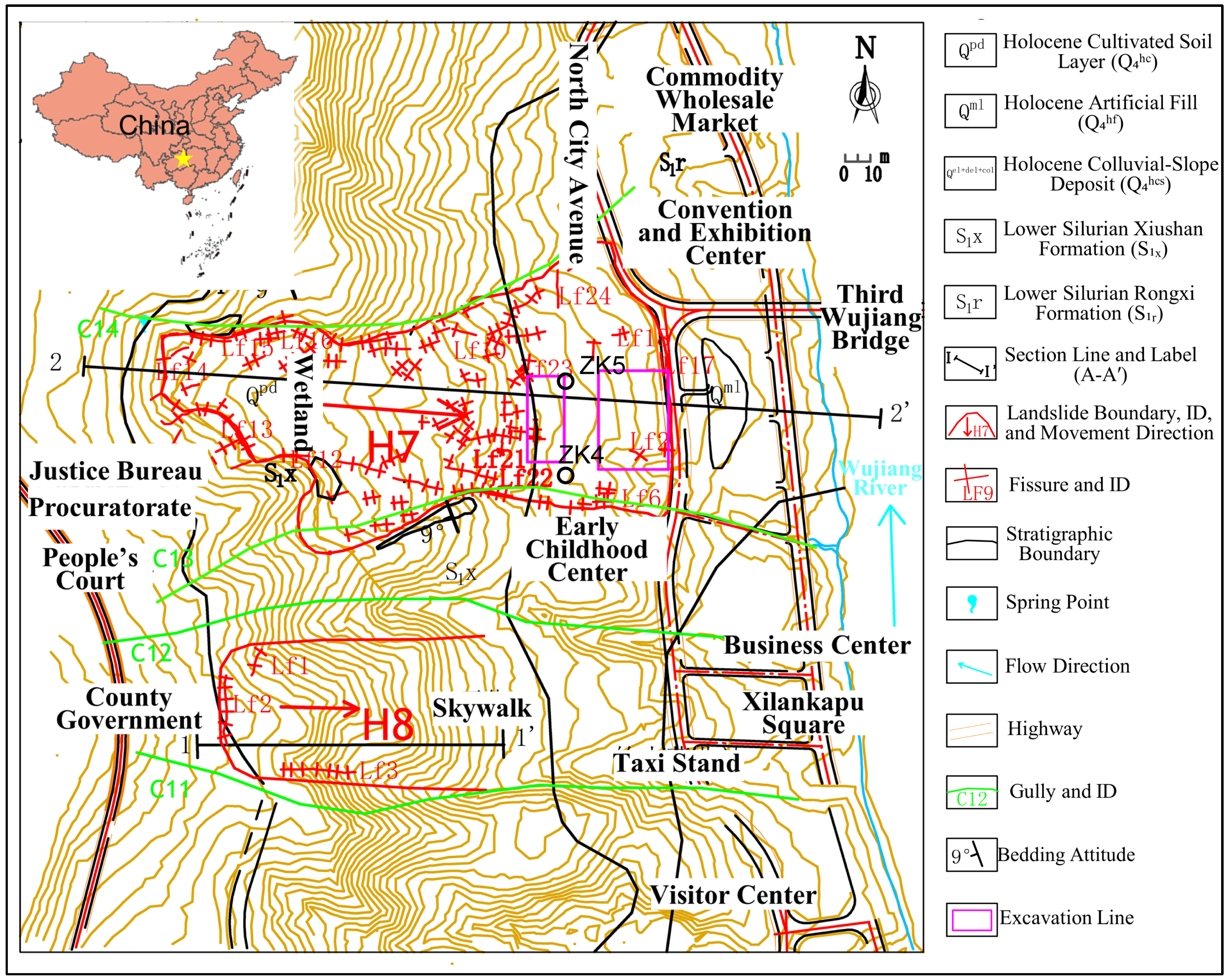
Figure 1. Landslide engineering geological plan.
Water 17 02640 g001
Figure 2. Engineering geological cross-section along profile 2-2′ of the landslide.
Water 17 02640 g002
Figure 3. (a) Material exposed in borehole ZK05; (b) material exposed in borehole ZK04.
Water 17 02640 g003
Figure 4. Deformation and failure mechanism of the Longdongpo landslide (Illustrated along profile 2-2′). (a) Initial Deformation Phase; (b) Rear-Slope Superficial Creep Phase; (c) Excavation-Induced Mid-Slope Creep Phase; (d) Global Failure Phase.
Water 17 02640 g004
Figure 5. (a) Longdongpo landslide model overview (b) 2-2′ typical cross-section geometry.
Water 17 02640 g005
Figure 6. Distribution of maximum principal stress (σ1, (af)) and minimum principal stress (σ3, (gl)) under different scenarios.
Water 17 02640 g006
Figure 7. Total displacement distribution under different scenarios (ah). (a) Total displacement in natural state; (bc) total displacement in excavation condition; (dh) total displacement under different rainfall infiltration: (d) h = 0.2 m, (e) h = 1 m, (f) h = 5 m, (g) h = 10 m, (h) h = 16 m.
Water 17 02640 g007
Figure 8. Plastic zone distribution under different scenarios (ah). (a) Distribution of plastic zones in natural state; (bc) distribution of plastic zones in excavation condition; (dh) distribution of plastic zones under different rainfall infiltration depths: (d) h = 0.2 m, (e) h = 1 m, (f) h = 5 m, (g) h = 10 m, (h) h = 16 m.
Water 17 02640 g008
Figure 9. Pore water pressure contours for profile 2-2′ under different rainfall infiltration depths. (a) h = 0.2 m; (b) h = 1 m; (c) h = 5 m; (d) h = 10 m; (e) h = 16 m.
Water 17 02640 g009
Table 1. Physico-mechanical parameters for FLAC3D simulation materials.
Materialγ_nat (kN/m3)γ_sat (kN/m3)c
(MPa)
φ (°)E (MPa)νk
(10−5 m/s)
n
Gravelly Soil19.621.60.02512.32220.353.50.4
Mudstone25.827.81.125.8582000.25<0.0001-
Notes: γ_nat: natural unit weight; γ_sat: saturated unit weight; c: cohesion; φ: friction angle; E: elastic modulus; ν: Poisson’s ratio; k: permeability coefficient; n: porosity.
Table 2. Summary of study scope: outcomes, constraints, and next steps.
AspectSummary
Achievements① Quantified synergistic triggering: Groundwater weakening (PWP buildup), excavation disturbance (catalyst), critical (>5 m) rainfall depth initiating failure (Figure 7g,h, Figure 8g,h and Figure 9d,e). ② Identified critical threshold: 5 m infiltration depth (site-specific) for catastrophic PWP surge (>2.7 MPa) and displacement (>2.2 m).
Limitations① Infiltration model: Steady-state saturation depth used (transient effects simplified; SWCC unavailable). ② Material parameters: Bedrock permeability (<10−9 m/s) based on field observation, not lab-tested. ③ Scope: Seismic/reservoir effects excluded. Critical depth (5 m) requires regional validation.
Future Work① Deploy inclinometers + piezometers for field validation. ② Conduct cyclic saturation tests on slip zone soil. ③ Perform transient seepage simulations. ④ Apply critical-depth framework regionally.
Disclaimer/Publisher’s Note: The statements, opinions and data contained in all publications are solely those of the individual author(s) and contributor(s) and not of MDPI and/or the editor(s). MDPI and/or the editor(s) disclaim responsibility for any injury to people or property resulting from any ideas, methods, instructions or products referred to in the content.