Article

Antecedent Rainfall Duration Controls Stage-Based Erosion Mechanisms in Engineered Loess-Filled Gully Beds: A Laboratory Flume Study

1
Institute of Geological Hazards Prevention, Gansu Academy of Sciences, Lanzhou 730000, China
2
College of Water Conservancy and Hydropower Engineering, Gansu Agricultural University, Lanzhou 730070, China
*
Author to whom correspondence should be addressed.
Water 2025, 17(9), 1290; https://doi.org/10.3390/w17091290
Submission received: 20 March 2025 / Revised: 19 April 2025 / Accepted: 24 April 2025 / Published: 25 April 2025

Abstract

:
Engineered loess-filled gullies, which are widely distributed across China’s Loess Plateau, face significant stability challenges under extreme rainfall conditions. To elucidate the regulatory mechanisms of antecedent rainfall on the erosion and failure processes of such gullies, this study conducted large-scale flume experiments to reveal their phased erosion mechanisms and hydromechanical responses under different antecedent rainfall durations (10, 20, and 30 min). The results indicate that the erosion process features three prominent phases: initial splash erosion, structural reorganization during the intermission period, and runoff-induced gully erosion. Our critical advancement is the identification of antecedent rainfall duration as the primary “pre-regulation” factor: short-duration (10–20 min) rainfall predominantly induces surface crack networks during the intermission, whereas long-duration (30 min) rainfall directly triggers substantial holistic collapse. These differentiated structural weakening pathways are governed by the duration of antecedent rainfall and fundamentally control the initiation thresholds, progression rates, and channel morphology of subsequent runoff erosion. The long-duration group demonstrated accelerated erosion rates and greater erosion amounts. Concurrent monitoring demonstrated that transient pulse-like increases in pore-water pressure were strongly coupled with localized instability and gully wall failures, verifying the hydromechanical coupling mechanism during the failure process. These results quantitatively demonstrate the critical modulatory role of antecedent rainfall duration in determining erosion patterns in engineered disturbed loess, transcending the prior understanding that emphasized only the contributions of rainfall intensity or runoff. They offer a direct mechanistic basis for explaining the spatiotemporal heterogeneity of erosion and failure observed in field investigations of the engineered fills. The results directly contribute to risk assessments for land reclamation projects on the Loess Plateau, underscoring the importance of incorporating antecedent rainfall history into stability analyses and drainage designs. This study provides essential scientific evidence for advancing the precision of disaster prediction models and enhancing the efficacy of mitigation strategies.

1. Introduction

Soil erosion is a global environmental challenge, and its dynamic processes are significantly coupled with soil moisture transport mechanisms. The spatiotemporal heterogeneity of soil water content directly regulates the nonlinear response of surface runoff to extreme rainfall events [1,2]. Moreover, recent investigations have highlighted the critical interplay between soil erosion and accelerated global warming, as changes in the global climate system introduce greater uncertainty into soil erosion dynamics [3,4]. The Sixth Assessment Report of the Intergovernmental Panel on Climate Change (IPCC) indicates an approximately 7% increase in extreme rainfall events for every 1.0 °C rise in the global mean temperature [5], which may trigger cascading soil erosion processes and intensify the frequency and magnitude of compound geological disasters, particularly debris flows and landslide chains [6,7]. Regional studies have indicated that the Eurasian continent is a hotspot for extreme rainfall events and faces particularly severe soil erosion challenges [8]. Notably, the Loess Plateau in China exhibits significantly enhanced erosional responses under equivalent rainfall intensities due to its unique Malan loess fabric, establishing it as one of the world’s most severely eroded and ecologically vulnerable regions [9]. The convergence of geomorphic predisposition, intensification of climate change, and enhanced human activity have created a “triple dilemma” scenario. Consequently, elucidating the synergistic erosion mechanisms driven by extreme rainfall and exacerbated by engineering disturbances has become a primary scientific imperative for safeguarding the ecological security of the Loess Plateau.
While rainfall has been widely recognized as the primary driver of soil erosion [10,11], its mechanisms are rarely the central focus of research, leading to persistent discrepancies in understanding erosion processes. Surface erosion rates are directly correlated with rainfall energy, whereas gully erosion development is predominantly controlled by runoff shear stress [12,13]. Rainfall plays a critical role in causing initial particle detachment through splash impacts and generating surface runoff that drives subsequent soil loss and sediment transport processes, ultimately leading to the formation and extension of gullies [14,15]. However, the influence of antecedent rainfall on post-storm erosion events is frequently overlooked. Notably, antecedent rainfall significantly reduces soil matric suction by altering hydrological states, thereby lowering the failure thresholds for subsequent extreme rainfall events [16,17]. Rahardjo et al. [18] indicated that the influence of antecedent rainfall on soil pore-water pressure is more significant in low-permeability soils than in high-permeability soils, and that the “pre-regulation effect” is also greater in the former. Numerical simulations have further revealed that when cumulative antecedent rainfall exceeds critical thresholds, slope safety factors decline rapidly [19]. Rahimi et al. [20] confirmed that antecedent rainfall patterns significantly influence slope stability by controlling the rate of safety factor reduction. However, in engineered loess soils exhibiting significant collapsibility, this mechanism presents a unique response. While these soils demonstrate excellent strength and stability in a low-saturation state, their stability significantly weakens under the influence of rainfall, which is the primary cause of slope instability and failure [21]. As a case in point, the Panzhihua Airport landslide on 3 October 2009 occurred due to the saturation of filled loess caused by antecedent rainfall, resulting in a liquefaction-type failure during a subsequent 58 mm/h rainfall event [22]. An in-depth investigation of the rainfall characteristics associated with soil erosion on the Loess Plateau is crucial for understanding the soil erosion mechanisms and devising effective mitigation strategies.
Laboratory physical model experiments are a crucial methodology for soil erosion mechanism research, enabling comprehensive process analysis through real-time monitoring of multiple physical fields (e.g., pore-water pressure, water content, and strain fields). Studies have shown that short-duration, high-intensity rainfall (e.g., 120 mm/h) rapidly detaches surface soil through high-energy raindrop impacts [23], while long-duration, low-intensity rainfall (e.g., 12 mm/h for 72 h) drives the transition from shallow sheet erosion to deep-seated sliding via infiltration–runoff coupling effects [24]. Through rainfall experiments on loess–bedrock-filled slopes, Guo et al. [25] showed that interface zones, such as the loess–bedrock interface, can form concentrated hydraulic gradients due to abrupt changes in permeability. Bryan and Poesen [26] found that the scale effect of slope length significantly influences the spatial distribution patterns of infiltration rates and runoff intensity. Through loess slope model tests under rainfall conditions, Cogan and Gratchev [27] revealed that stability factors deteriorate rapidly when the precipitation intensity exceeds the infiltration threshold under unsaturated conditions. However, existing research is mostly limited to the analysis of single driving factors, lacking a systematic understanding of the synergistic erosion mechanisms of extreme rainfall–runoff dynamic coupling and anthropogenic engineering disturbances, which constrains the prediction accuracy of erosion models and targeted engineering protection in complex environments.
Although the threat of extreme rainfall to loess fill slope stability in western China’s land reclamation projects has been acknowledged, the precise mechanisms by which antecedent rainfall modulates subsequent erosion damage remain inadequately understood. To address this critical knowledge gap, this study combines field observations and controlled laboratory flume experiments to systematically investigate the influence of antecedent rainfall duration on the erosion and failure processes of engineered loess-filled gully beds. The investigation revealed a demonstrably phased erosion mechanism, highlighting the role of antecedent rainfall as a “critical regulator” that fundamentally alters soil hydrological conditions and thereby modifies subsequent erosion pathways and intensities. These findings provide novel insights into the complex interplay between antecedent rainfall and erosion dynamics in loess fill slopes, providing an essential scientific basis for risk assessment and mitigation strategies in similar geo-environmental settings.

2. Materials and Methods

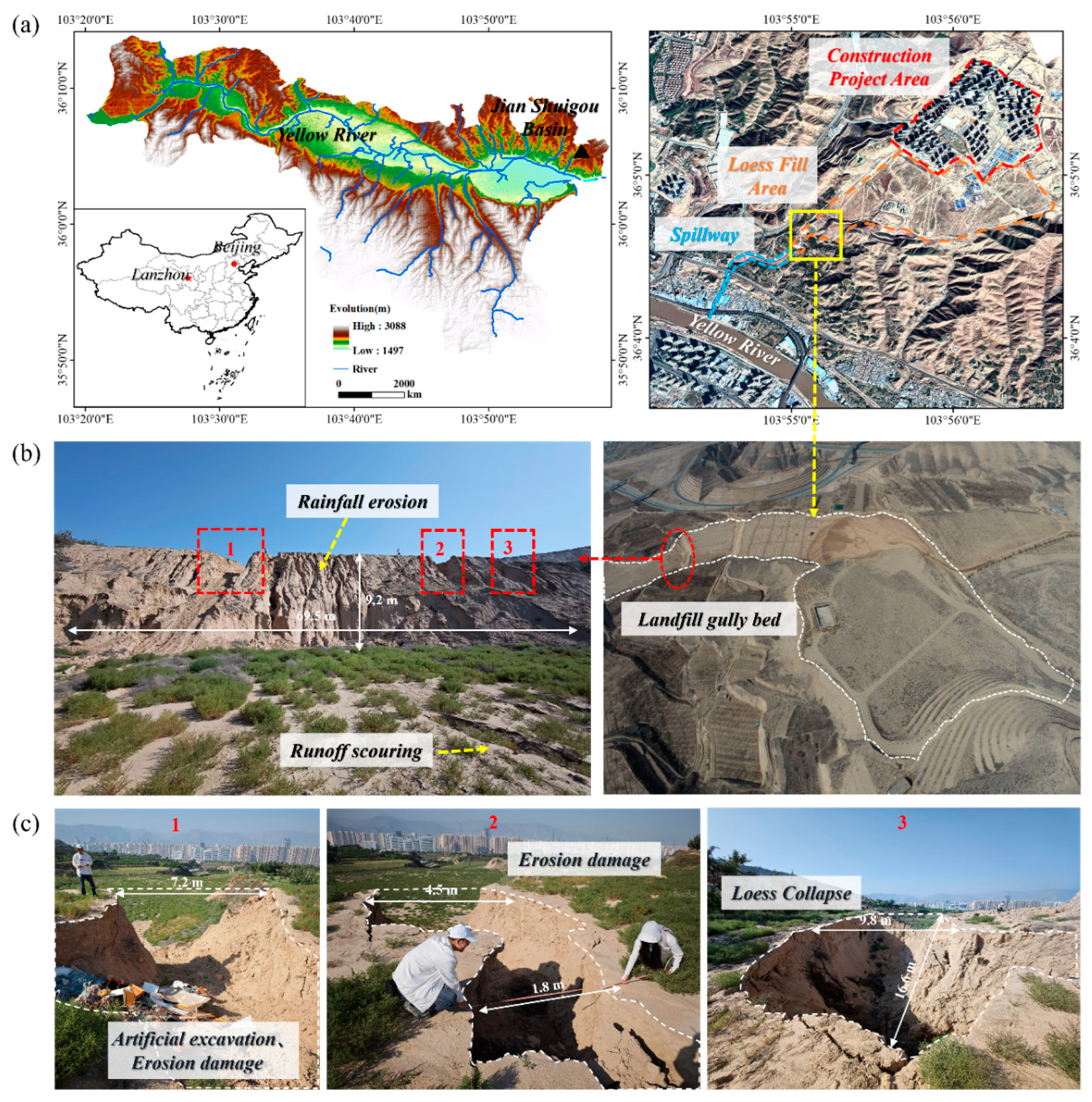
2.1. Study Area Description

The urbanization process of the Loess Plateau in China faces the dual constraints of land resource scarcity and frequent geological disasters [28]. To overcome this predicament, cities such as Yan’an in Shaanxi Province and Lanzhou in Gansu Province have implemented a large-scale “Mountain Bulldozing and Land Creation Project” to accelerate urban expansion [29]. However, these extensive engineering practices, typically involving “blasting to flatten mounds and gully filling”, inevitably disturb and reshape the natural loess structure, potentially leading to significant environmental and geological consequences [30]. Due to these excavation and filling measures, the loess structure under natural conditions is inevitably disturbed and reshaped, and its uncompacted and loose structure renders it extremely prone to deformation and instability when subjected to external environmental factors. The manual excavation and filling involved in these projects have resulted in numerous engineered loess-filled gully beds and steep slopes across valley networks [31]. The majority of gullies along both banks of the main urban area in Lanzhou are seasonal mountain torrents that typically lack runoff throughout the year, with extreme rainfall serving as the dominant factor driving regional soil and water loss.
This study focuses on the Jianshuigou watershed on the north bank of the Yellow River in Lanzhou City, China (103°40′–103°48′ E, 36°03′–36°12′ N). Situated at elevations ranging from 1650 to 1900 m above sea level, this watershed features a landscape characterized by loess hills and erosion–accumulation gullies, exhibiting significant long-term fluvial erosion. This region experiences a temperate and semi-arid climate with a mean annual precipitation of approximately 310 mm. Notably, the rainy season extends from June to September and is characterized by short-duration, high-intensity rainfall events that constitute 60–70% of the total annual precipitation [32]. The original V-shaped valleys in the area were transformed into stepped-filled terrace systems through “land creation” projects (Figure 1b). A representative terrace measures 69.5 m in length and 102 m in width, with an approximate height of 9.2 m. The terrace surface slopes range from 3° to 9°, while those of the filled loess range from 30° to 45°. Following multiple rainfall and runoff events, numerous collapse sinkholes, piping channels, and headward-eroding gullies have developed on the terrace surface (Figure 1c). Field investigations indicate that soil erosion and water loss in these filled gully beds are highly sensitive to rainfall, suggesting that the already severe erosion in this region will become more intense and widespread in the coming decades due to climate change [33]. This underscores the urgency of elucidating the feedback mechanisms between antecedent rainfall and the filled structure and constructing an adaptive prevention and control system. This has paradigmatic significance for the sustainable management of engineered landforms in climate-sensitive regions globally.

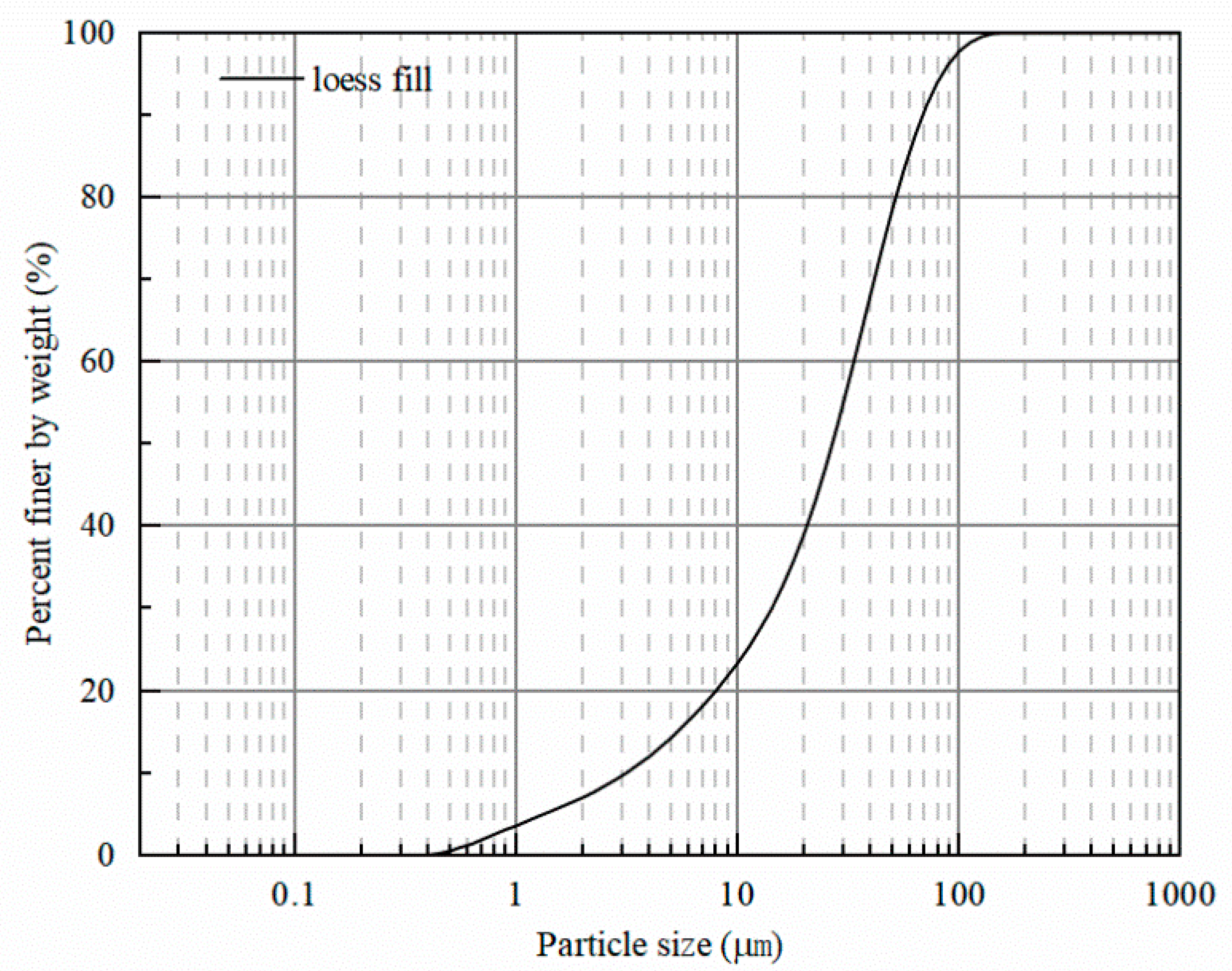
2.2. Physical Properties of the Materials

The soil samples used in this study were collected from a representative engineered loess fill site in Lanzhou City, Gansu Province, China. A series of laboratory geotechnical tests were conducted to characterize the engineering properties of the material, including its physical and hydraulic characteristics (Table 1). Particle size distribution analysis was performed using a Malvern Mastersizer 2000 laser (Malvern Instruments, Malvern, UK) diffraction particle size analyzer, indicating that the filled loess predominantly comprises silt- and clay-sized particles. The soil exhibits a well-graded particle size distribution, with characteristic particle sizes of: d50 = 0.026 mm and d10 = 0.0031 mm (Figure 2).

2.3. Experimental Design

Based on field observations of typical engineered filled loess beds on the Loess Plateau, a multi-factor coupled erosion experimental system was designed to investigate the regulatory mechanisms of antecedent rainfall on soil erosion. The detailed parameters are listed in Table 2. The experimental protocol comprises three consecutive phases, simulating the natural rainfall and runoff processes characteristic of the Loess Plateau region: (1) the rainfall phase, with simulated precipitation initiated and terminated at predetermined durations of 10 min (T1), 20 min (T2), and 30 min (T3); (2) the 10-min intermittent phase, replicating the typical inter-rainfall intervals observed in field conditions; and (3) the runoff phase, initiated after the intermission, simulating surface runoff generation under extreme precipitation conditions, with a 30-min duration. The duration of the runoff phase was determined based on preliminary experiments to ensure the consistency and measurability of the erosion process.
To establish realistic and extreme rainfall parameters for the simulation experiments, the Gansu Province Rainstorm and Flood Atlas were used. The analysis revealed that the 100-year maximum 1-h rainfall for Lanzhou City is 51.9 mm, and the maximum 10-min rainfall is 18.6 mm. Employing a conservative approach to represent extreme rainfall conditions, a mean maximum 10-min rainfall intensity of 1.3 mm/min (equivalent to 78 mm/h) was selected for all experiments. The physical setup of the experimental flume was designed based on field investigations of representative engineered loess-filled gully beds. Specifically, the flume bed slope was set at two angles, 9° and 12°, reflecting the typical gradients observed in the field. Prior to each experimental run, the selected slope angle was precisely calibrated using a spirit level to ensure accuracy and consistency across trials. To investigate the influence of antecedent rainfall duration, several key variables were rigorously controlled throughout the experiments: the rainfall intensity during the antecedent phase was fixed at 1.3 mm/min, the flow rate during the subsequent main runoff phase was maintained at a constant 15 L/min [34], the duration of this runoff phase was fixed at 30 min, and a consistent initial dry density was ensured for the soil bed in all the treatments. The detailed parameters for each experimental condition, including the specific antecedent rainfall durations tested (T1, T2, and T3), are listed in Table 2. Soil preparation involved several steps to ensure uniformity and relevance to the field conditions. First, the collected engineered loess fill material was sieved through a 20 mm mesh to remove coarse particles. The initial gravimetric water content was adjusted to approximately 10%. Finally, an experimental gully bed within the flume was constructed by compacting the prepared soil in two layers, each precisely 6 cm thick (total depth of 12 cm). Uniform compaction for each layer was achieved using a wooden mallet, aiming to replicate the target in situ dry density of the engineered loess fill material.

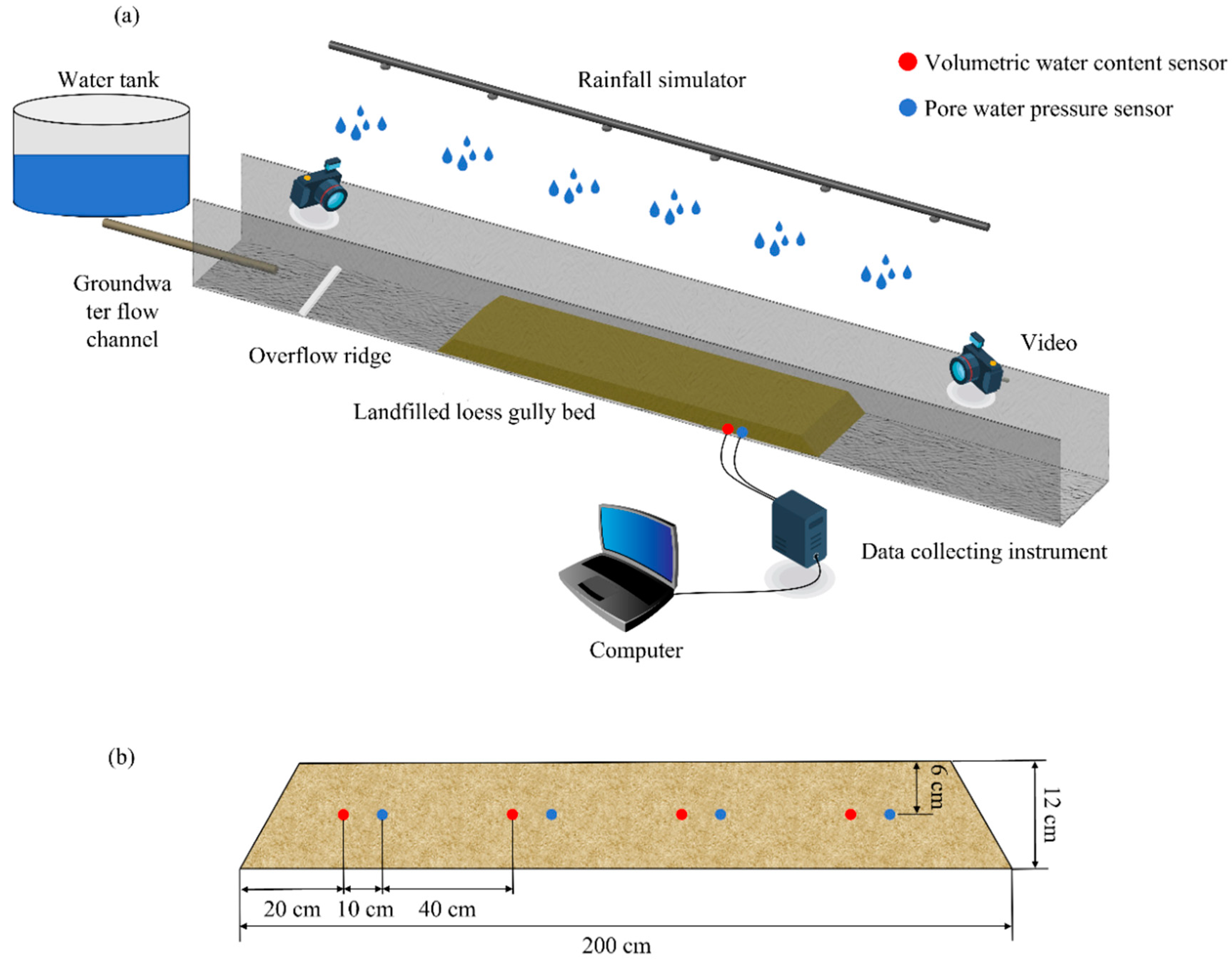
2.4. Experimental Apparatus

Flume experiments were conducted using a landslide and debris flow simulation apparatus housed at the Institute of Geological Hazards Prevention, Gansu Academy of Sciences (Figure 3). The experimental system consisted of three main components: a flume, a runoff simulation system, and a rainfall simulation system. Tap water was utilized for all experimental procedures involving water application. The flume channel measured 6.5 m in length, 0.5 m in width (adjustable between 0 and 0.8 m), and 0.8 m in height. Its sidewalls, constructed with tempered organic glass, were marked with a 5 cm × 5 cm grid to facilitate the visual observation and documentation of gully bed erosion development throughout the experiments. The runoff simulation system, designed to deliver a controlled overland flow, consisted of a water tank, water pump, flow meter (operational range: 9–100 L/min), and control valve. This setup enabled precise monitoring and regulation of runoff discharge. To ensure a uniform flow distribution across the channel inlet, a fixed-height overflow weir (1 cm high) was installed at the upstream end, promoting a shallow and evenly spread flow layer over the soil surface. The rainfall simulation system, responsible for applying precipitation, included a water tank, a water pump, water pipes, specialized nozzles, a control valve, and a flow meter. To ensure the accuracy and spatial uniformity of the simulated rainfall, a rain-gauge array was used to quantify the rainfall uniformity across the flume surface prior to the experiments, and the measurements confirmed spatial uniformity exceeding 85%.
To capture the hydrological changes induced by antecedent rainfall and link them to subsequent erosion and potential failure processes, both the volumetric water content and pore-water pressure were continuously monitored throughout the experiments. The volumetric water content reflects the soil moisture level and degree of saturation, while pore-water pressure indicates the pressure exerted by pore water, which directly influences the soil’s mechanical stability and shear strength. The experimental setup included four volumetric water content sensors (Model GS-3, ±0.1% accuracy, METER Group, Pullman, WA, USA) and four pore-water pressure sensors (Model HC-25, ±0.1 kPa accuracy, Hengrui Company, Beijing, China). These sensors were arranged in two pairs along the gully centerline and embedded 6 cm below the initial soil surface, as shown in Figure 3b. Prior to each experimental run, all sensors and associated data-logging systems were carefully calibrated and zeroed to ensure the accuracy and reliability of the recorded data. The gully bed erosion processes were recorded using a dual-camera system employing two high-definition cameras (Pocket 2, 4 K) positioned above and obliquely in front of the flume, providing stereoscopic visual records of the evolving erosional morphology. Post-experiment data processing, analysis, and graphical representation were conducted using Origin 2021(Version 9.8) software.

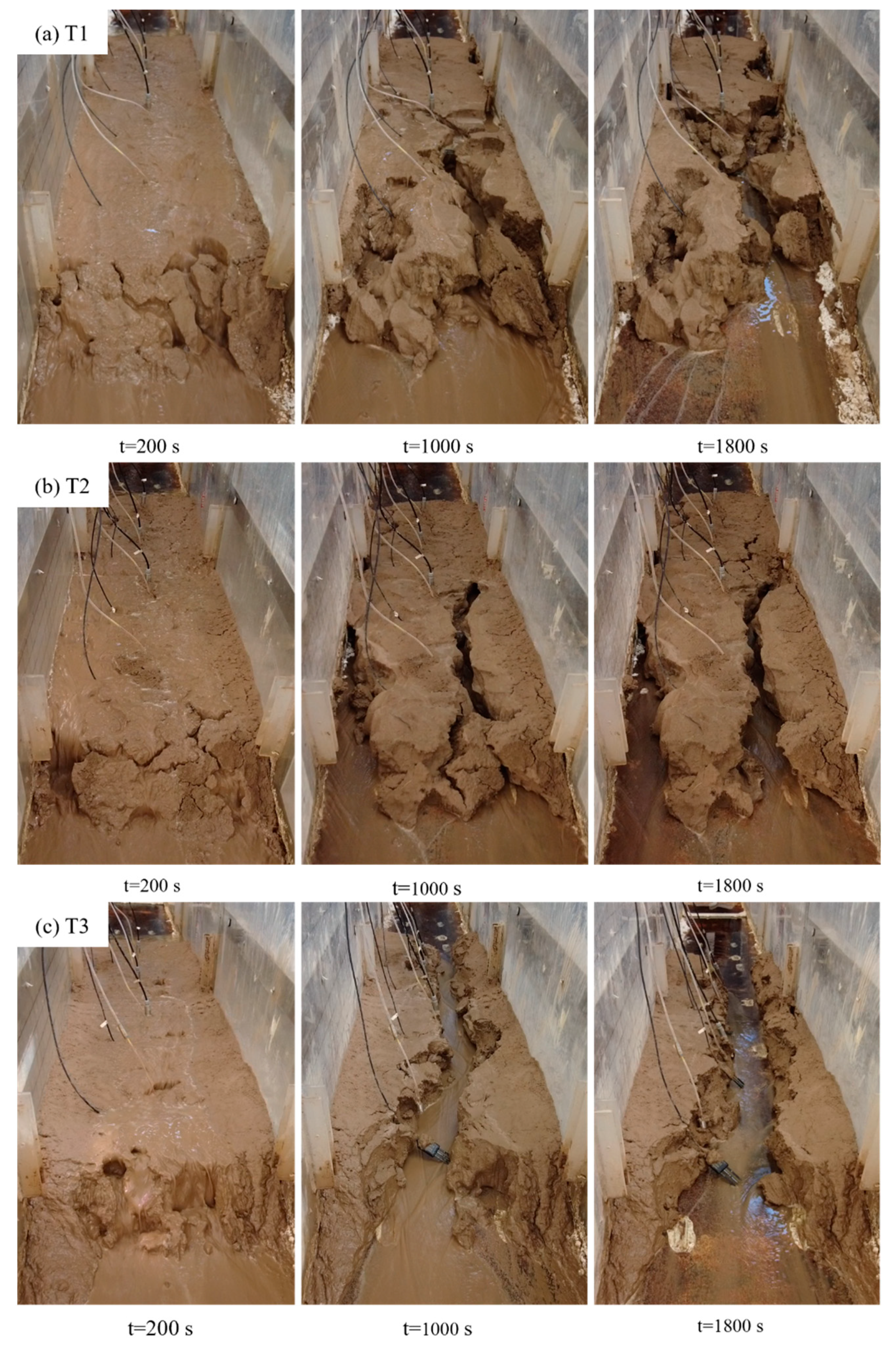
3. Experimental Observations

3.1. Phased Evolution of Infilled Loess Gully Bed Erosion Under Antecedent Rainfall Regulation

Extensive low-compaction loess-filled gully systems formed during engineering activities exhibit loose structural configurations that are highly susceptible to moisture-induced erosion failures. While loess typically demonstrates high strength and stability under low-saturation conditions, rainfall infiltration significantly weakens its mechanical stability [35,36]. Therefore, laboratory-simulated rainfall experiments were specifically designed and conducted to systematically observe and meticulously document the erosion and failure processes of loess-filled gully beds. The experimental results clearly demonstrate that the erosion and failure processes of loess-filled gully beds can be systematically categorized into the following distinct and representative phases, with evolutionary characteristics closely linked to the antecedent rainfall conditions.

3.1.1. Raindrop Impact Phase

During the initial rainfall phase, the gully bed surface is initially subjected to the direct impact of raindrops. Due to the relatively gentle slope gradient, the efficiency of potential energy conversion to kinetic energy is constrained, resulting in relatively low initial runoff volumes and limited erosional energy. Visually, this manifests as the gradual removal of loosely structured fine particles, with incipient micro-rills and sporadic sheet erosion patterns emerging in localized zones. As rainfall continues, localized soil masses in the downstream gully bed progressively saturate and soften, reducing the engineering properties and stability and leading to the initiation of small-scale shallow slumps.

3.1.2. Intermission Phase

Following the simulated rainfall phase, the experiment entered a pre-defined intermittent period. As shown in Figure 4, the coupled effects of antecedent rainfall infiltration and post-rainfall wetting–drying cycles exert complex composite impacts on the gully bed surface layer. In the T1 and T2 experiments, continued infiltration during the intermittent period demonstrably induced surface cracks. Notably, the cracks in the T2 group exhibited more pronounced development in both area and depth (Figure 4a,b), suggesting that shorter antecedent rainfall durations may be more conducive to internal stress redistribution and crack propagation in the soil. In contrast, the gully bed in the T3 group primarily exhibited overall collapse and settlement (Figure 4c), indicating that longer antecedent rainfall durations significantly altered the soil structure, making it more prone to overall deformation. Crack formation provides preferential flow pathways for subsequent rainfall events, thereby macroscopically enhancing the overall permeability of the soil; however, from an engineering stability perspective, cracks inherently reduce the structural integrity and inherent stability of the soil mass [37]. Conversely, the T3 gully bed, which was subjected to a longer antecedent rainfall duration, exhibited a more immediate and widespread response, characterized primarily by overall subsidence and volumetric deformation (Figure 4c). This saturation-induced collapsibility mechanism dominated the T3 experiments, such that the influence of the crack-induced preferential flow was overshadowed by the overall structural failure. This observation aligns with previous research demonstrating the susceptibility of loess to overall collapse under rainfall conditions [38]. The phenomena observed in the T3 group further corroborate that under prolonged antecedent rainfall, loess-filled gully beds are more prone to overall failure dominated by saturation-induced collapse rather than localized erosion and failure controlled by crack-induced preferential flow. In this case, the dominant failure mechanism shifts from crack-induced preferential flow to more pervasive saturation-induced structural failure.

3.1.3. Runoff Scouring–Gully Evolution Phase

Following the intermittent phase, the simulated runoff phase commenced, and the erosion and failure of the gully bed entered a critical period of rapid evolution and intense development. As shown in Figure 5, while all experimental groups exhibited pronounced gully expansion and incision, the rate and morphology of gully development varied significantly depending on the antecedent rainfall conditions. Runoff flowed from higher to lower elevations in the gully bed, successively undergoing sheet erosion, rill erosion, and gully erosion. Accompanying the occurrence and progression of headward gully erosion, the gully head continuously advances and entrains significant quantities of sediment. Sediment-laden runoff continued to incise the gully bed, substantially increasing incision depth and erosion volume. Crucially, this phase was characterized by strong hydromechanical coupling, with the scouring action of concentrated runoff actively destabilizing gully walls and frequently triggering collapses and slumps. This synergy between hydraulic erosion and mass wasting resulted in dramatic morphological changes (Figure 5, t = 1800 s). Furthermore, the development of subsurface voids within the gully bed was also observed during the experiments, suggesting that both piping and dissolution may occur concurrently within the gully bed under the influence of flow. This observation led to the hypothesis that the nature of internal erosion might also be influenced by antecedent conditions: short-duration rainfall could promote localized piping along crack-induced preferential pathways (manifesting as distinct voids), whereas prolonged saturation (long-duration rainfall) might lead to more diffuse internal weakening associated with incipient collapse, potentially without the formation of easily observable large voids. This proposed difference in internal erosion mechanisms and manifestations under varying antecedent rainfall conditions offers a novel perspective that may have been overlooked in previous studies.

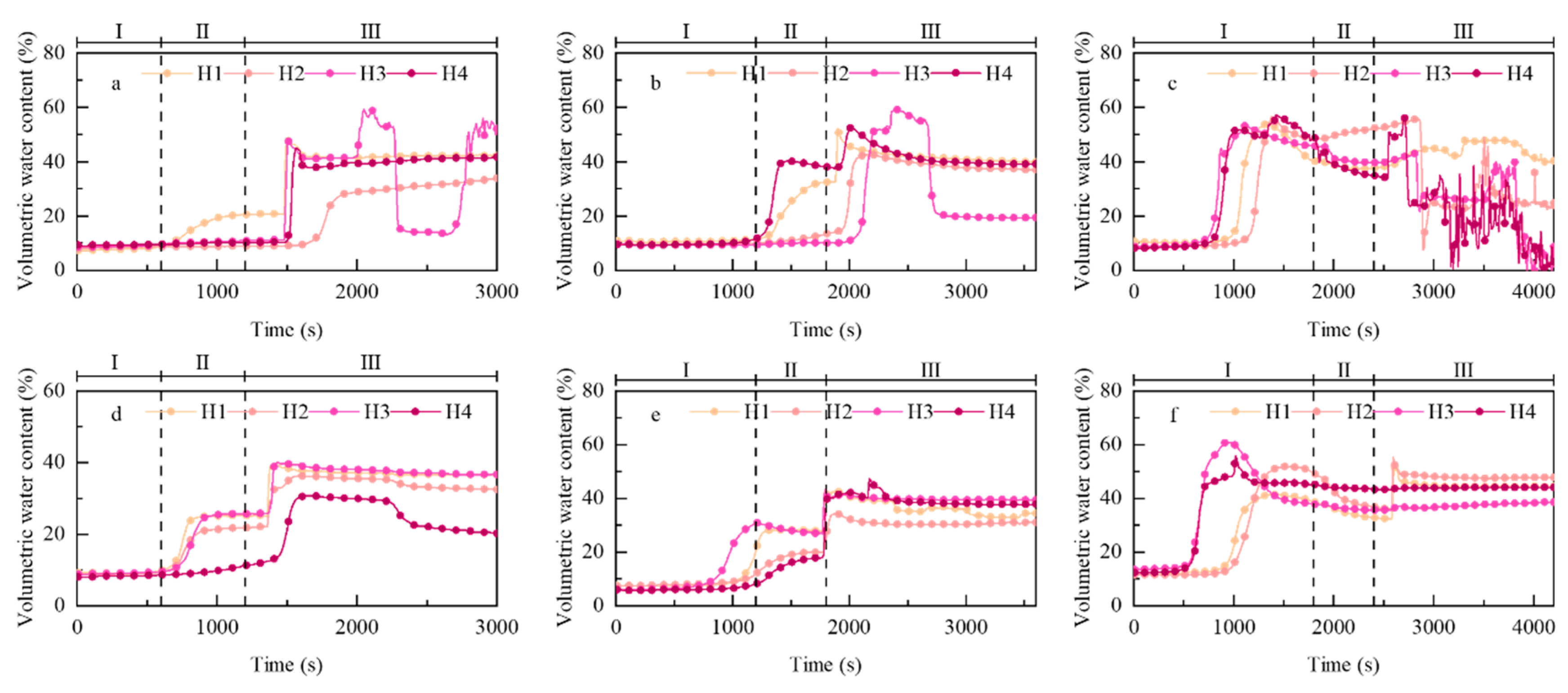
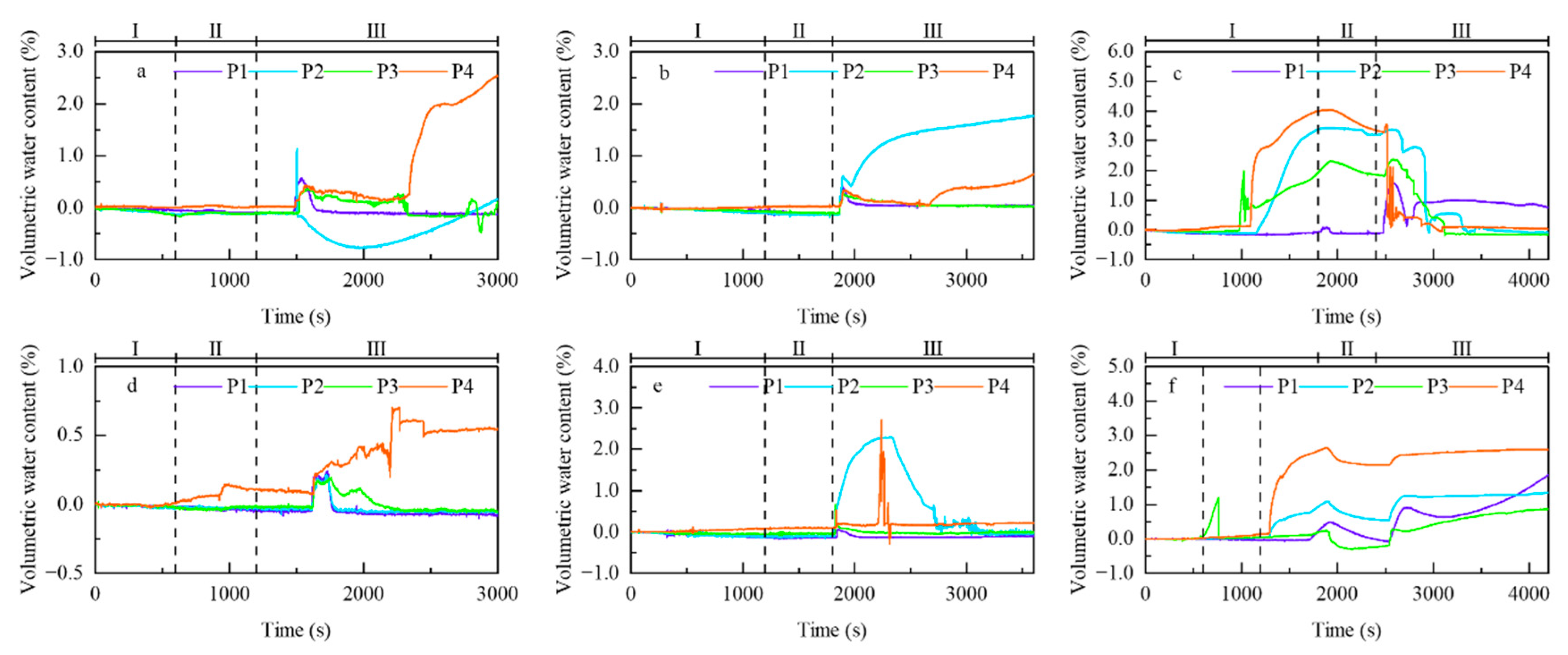
3.2. Soil Hydrological Response Patterns

The dynamic changes in the volumetric water content during the experiments clearly illustrate the influence of antecedent rainfall duration on the hydrological state of the engineered loess fill, as exemplified by the results from the 9° slope tests (Figure 6). Distinct volumetric water content response patterns emerged under varying antecedent rainfall durations. Initially, during the rainfall phase, a common lag period was observed before the volumetric water content sensors responded, which was attributable to the time required for rainwater infiltration [39]. Significant increases in volumetric water content typically began after approximately 20 min of sustained rainfall, as the wetting front progressively descended through the soil profile. During the subsequent intermittent phase, the volumetric water levels generally stabilized across all treatment groups. However, the onset of the main runoff scouring phase triggered abrupt surges in the volumetric water content at the sensor locations. This rapid increase is likely due to a combination of surface runoff recharge and potentially enhanced infiltration under saturated or near-saturated conditions. In the later stages of the runoff phase, the volumetric water content at the monitoring points typically approached or reached saturation. Notably, the duration of antecedent rainfall significantly impacted the initial moisture state before the main runoff phase commenced. Longer antecedent rainfall durations (e.g., T3) resulted in substantially higher initial volumetric water content levels than shorter durations (T1, T2). Furthermore, during the subsequent scouring phase, these initially wetter soil profiles (T3) exhibited more pronounced fluctuations in volumetric water content (Figure 6), indicating heightened sensitivity or dynamic response under runoff conditions. This finding corroborates the critical influence of initial moisture conditions, modulated by antecedent rainfall, on subsequent hydrological responses during erosion events. At the local scale, changes in soil water content exhibit strong synchronicity with localized erosion and failure responses of the gully bed. The volumetric water content sensors recorded noticeable fluctuations when deformation and failure occurred in the bed, indicating that moisture content changes are critical precursors of soil destabilization and erosional failures [40].
Pore-water pressure dynamics also exhibited characteristic variations closely coupled with the experimental phases (rainfall, intermittent, and runoff) and the progression of erosion and failure [41,42]. Pore-water pressure fluctuations primarily occur during the soil failure stage, and the fluctuation magnitudes are positively correlated with the damage severity. In the initial stages of the experiments (early rainfall phase), when gully bed deformation was mainly associated with gradual processes like soil creep due to wetting and surface splash erosion, the pore-water pressure response was relatively slow and gradual. However, as the antecedent rainfall duration increased (particularly notable in the T3 condition; Figure 7), continuous infiltration significantly reduced the effective stress. This led to observable bed surface subsidence and a more pronounced elevation in pore-water pressure, even before the main runoff phase began. Subsequent runoff scouring further exacerbates surface instability and gully bed damage, causing pronounced pore-water pressure fluctuations (Figure 7). Particularly significant fluctuation amplitudes in specific zones reflect dynamic effective stress adjustments and rapid pore pressure responses during soil failure processes [43]. Notably, in contrast to the gradual variations during the rainfall stages, the pore-water pressure changes ooccur almost instantaneously, rising sharply within 1–2 s before quickly receding and stabilizing. The instantaneous and abrupt variation is likely related to rapid erosional gully formation under runoff action, which induces lateral soil destabilization and slumping, subsequently obstructing drainage and triggering sudden pore-water pressure surges.

4. Results and Discussion

4.1. Regulation of Macro-Scale Phased Evolution

The erosional failure of engineered loess gully beds constitutes a complex multi-stage evolutionary process, sequentially undergoing raindrop-splash erosion, soil structure adjustment during hiatus periods, and runoff scouring and gully evolution. The antecedent rainfall duration is a critical “pre-regulation” factor that significantly regulates the evolutionary characteristics of each stage of the moth. As the initiating phase of erosion, raindrop-splash erosion exhibits a relatively low intensity. However, distinct gully bed responses under varying antecedent rainfall conditions would have already emerged, foreshadowing the “pre-regulation” effect of antecedent rainfall on subsequent erosional evolution. The intermittent phase marks a critical transition point in the erosion evolution. Different antecedent rainfall durations result in distinct soil states: under short-duration antecedent rainfall (T1 and T2), crack development becomes the dominant feature, providing preferential seepage pathways for subsequent flow [44]. In contrast, prolonged antecedent rainfall (T3) induces comprehensive hydro-collapse and subsidence, demonstrating that extended saturated infiltration significantly alters the soil structure and makes it more prone to overall failure, which is consistent with the classical understanding of loess collapsibility [45]. The subsequent runoff scouring–gully evolution phase amplifies the differential impact of antecedent rainfall. The T3 group exhibits markedly accelerated and intensified erosional damage, validating the significant enhancement effect of antecedent rainfall on subsequent erosional processes. Consequently, the antecedent rainfall duration profoundly influences the staged evolutionary pathways and ultimate failure mode of gully bed erosion.

4.2. Micro-Scale Hydromechanical Mechanisms

From a hydromechanical perspective, the duration of antecedent rainfall dictates the initial hydrological state and structural integrity of the engineered gully bed soil before the main erosion event. Short-duration antecedent rainfall primarily induces crack networks during the intermittent period, while long-duration antecedent rainfall dominates saturation-induced collapse and soil structure weakening. These two distinct “pre-regulation” paths fundamentally determine the soil’s ability to resist subsequent runoff scouring erosion. This mechanism is further confirmed by the theory of unsaturated soil shear strength [46] and the soil erosion models [47].
τ = c + σ   u a tan φ c = c + u a   u w tan φ
where τ is the shear strength of the unsaturated soil, c is the cohesion, c’ is the effective cohesion, ua is the pore air pressure in the soil, uw is the pore-water pressure in the soil, φ is the internal friction angle, and φ’ is the internal friction angle of the soil that varies with the matric suction.
E r = K e ( τ τ c )
where Er is the soil erosion rate, Ke is the soil erodibility parameter, τf is the flow shear stress, and τc is the critical flow shear stress.
The above equation shows that when τ < τc, soil particles are not eroded; if the opposite is true, then erosion occurs. That is, the greater the critical shear stress for the initiation of soil particle movement, the more resistant the soil becomes to erosion. The critical shear stress for the initiation of soil particle movement can be expressed as [48]
τ c = 2 3 g d ( ρ s ρ w ) tan φ
where g is the acceleration due to gravity, d is the median particle diameter, ρs is the soil particle density, ρw is the water density, and φ is the internal friction angle of soil particles.
Antecedent rainfall significantly reduces soil erosion resistance by altering the hydromechanical state of the gully bed soil, creating more favorable conditions for subsequent runoff erosion. Specifically, antecedent rainfall increases the soil water content. According to the unsaturated soil shear strength theory, an increase in water content reduces the matric suction, thereby decreasing the soil shear strength. Specifically, increased soil water content directly reduces the matric suction, a key component of shear strength in unsaturated soils. Consequently, the overall shear strength of the soil decreases. This reduced shear strength directly translates to lower erosion resistance. According to established soil erosion models, soil with diminished resistance is more susceptible to detachment from flowing water; it requires less shear stress from runoff to initiate erosion (i.e., the critical shear stress is reduced) and exhibits a higher erosion rate under equivalent flow conditions.

4.3. Scaling Relationships and Significance of Antecedent Rainfall Pre-Regulatory Effects

Through controlled-variable flume experiments, this study quantitatively reveals the “pre-regulation” mechanisms and phased differentiation characteristics of the antecedent rainfall duration during erosion evolution in engineered loess-filled gullies. This finding effectively addresses the theoretical gap regarding our insufficient understanding of soil moisture mechanisms across multiple temporal scales [49]. Experiments have demonstrated that antecedent rainfall exerts impacts far beyond hydrological replenishment [50] and surface-wetting effects [51]. Its critical mechanism involves systematically reconstructing the initial hydro-physical states and structural integrity of the soil, thereby significantly regulating the triggering thresholds and dominant patterns of subsequent erosion processes [52]. More importantly, comprehending these divergent failure pathways (e.g., fracturing and collapse) triggered by differing antecedent conditions provides a crucial mechanistic lens for explaining the spatiotemporal heterogeneity in gully expansion rates and the morphological changes detected in field studies via remote sensing [53,54,55]. For instance, the intensified collapse and erosion observed after long-duration antecedent rainfall may correspond to the accelerated gully expansion detected by remote sensing during the post-wet period. This aligns with Wang et al.’s [56] theoretical model based on a 50-year remote sensing analysis, which highlights “annual runoff depth–soil bulk density” controls: antecedent rainfall preconditions soil erosion sensitivity by modifying local hydrological response thresholds and soil physical states prior to erosive events. The spatiotemporal heterogeneity of antecedent hydrological conditions likely constitutes the underlying mechanism for macroscopic spatial differentiation patterns by modulating the soil response sensitivity to subsequent erosive rainfall. While consistent with the classical theory of rainfall intensity sensitivity, this study innovatively reveals the decisive regulatory role of pre-event initial soil states on erosion sensitivity.

4.4. Insights from Experimental Results into the Fragility of Anthropogenically Modified Landforms

Applying the results of this study within the macro-context of extreme storm events on the Loess Plateau reveals the dominance and scale dependency of different erosion types. Field investigations by Yang et al. [57] strongly demonstrated that during catastrophic storms, landslides contribute the majority (over 90%) of the total erosion at the watershed scale, consistent with the global understanding that large-scale landslides dominate sediment production in mountainous basins [58]. Although laboratory flume experiments cannot fully replicate large-scale, gravity-dominated slope failures, they provide essential insights into the hydromechanical processes governing erosion at the scale of individual gullies and engineered features within the landscape. Additionally, gully erosion along unpaved roads and the collapse of terrace embankments are recognized as critical “erosion hotspots” that exhibit exceptionally high intensities. This study observed that fill soils, once softened by antecedent rainfall, demonstrated a marked decrease in resistance to runoff erosion, making them highly susceptible to rapid gully incision and instability-induced collapse. This offers critical mechanistic explanations for how human-modified surfaces (such as roads and terraces, which represent typical engineered fills) serve as “amplifiers” of storm-driven erosion. Particularly, the vulnerability of newly constructed or poorly maintained terraces essentially reflects the susceptibility of inadequately compacted and structurally unstable fills to hydraulic forces, which was the central focus of this experiment. The vulnerability of engineered fills is not unique to the Loess Plateau; large-scale land reclamation projects in coastal regions also face significant challenges [59,60]. Both loess-filled gullies and coastal land reclamation represent anthropogenic landscapes formed by the placement and often compaction of earth materials. This process inherently disrupts the natural soil structure, fabric, and cementation, leading to materials that are typically less dense, more heterogeneous, and possess lower intrinsic shear strength than their undisturbed counterparts. This renders them fundamentally susceptible to post-construction adjustments under external stress, particularly in hydrological loading [61]. Engineered loess fills are often placed within existing gullies, potentially overlying relatively suitable bedrock or older loess deposits. Conversely, coastal reclamation occurs over soft, highly compressible, low-strength marine, and estuarine sediments. This difference implies that foundation stability and long-term consolidation settlement are often more critical governing factors in coastal projects than in loess gullies [62,63]. Although coastal backfill zones and reclaimed platforms differ in material composition, dominant hydrological drivers, and foundation conditions, the fundamental principles highlighted in this study are significantly relevant. Specifically, it emphasizes the crucial role of antecedent moisture conditions in “pre-regulation” soil structural integrity and in determining subsequent failure modes and erosion susceptibility. Understanding the temporal dimension of hydrological influence and complex hydromechanical coupling is crucial for assessing the stability and predicting the long-term performance of engineered fills in both terrestrial loess landscapes and dynamic coastal environments. This study underscores the necessity of site-specific characterization while also providing a valuable process-based analytical framework for analyzing water-induced instability in diverse engineered fills.
In summary, by focusing on the specific and critical landscape units of engineered loess fills, this study deepens our understanding of the complexity of rainfall erosion processes at the hydromechanical level. It provides an important process-based foundation and valuable mechanistic explanation for interpreting erosion phenomena observed during extreme events at more macroscopic scales. The universality of this study’s conclusions is constrained by inherent laboratory limitations, including scale effects, boundary condition simplifications, and the representativeness of the remolded soil samples. Laboratory flumes inevitably involve scale reductions and artificial boundary conditions, which differ from complex open-field slopes; field-scale natural gully turbulent flow structures, sediment transport capacity, and lateral bank erosion dynamics may not scale linearly [64,65,66]. Although using sieved and recompacted loess fill was necessary for experimental control and repeatability, it cannot fully capture the intricate structural heterogeneity, potential layering, macropore networks, and variable cementation commonly found in both in situ engineered fills and natural loess deposits. These structural differences can significantly influence infiltration patterns, preferential flow, soil erodibility, and instability initiation points [67]. Critically, the pronounced discrepancy in ionic composition and pH between the tap water utilized experimentally and natural rainwater likely suppressed the dispersion of loess particles, potentially leading to an underestimation of actual erosion rates and influencing the observed thresholds for the failure modes [68]. Furthermore, our study did not encompass critical environmental factors, such as vegetation or freeze–thaw cycles. These limitations highlight the need for future research that integrates multi-scale field observations, develops coupled multi-process numerical models, and translates findings into practical applications to refine and validate the understanding gained herein. This would enhance the predictive accuracy and risk assessment capabilities of the long-term stability of large-scale engineered landforms globally.

5. Conclusions

Erosion and failure of loess-filled gully beds exhibit pronounced, phased evolutionary characteristics. This process is neither singular nor linear, but sequentially progresses through three internally connected yet distinct stages: initial raindrop-splash erosion, intermission-induced soil structural adjustments (including crack development or collapse), and subsequent rapid gully erosion driven by runoff scouring.
The antecedent rainfall duration is a critical “pre-regulation” factor that controls the evolution pathway and intensity of erosion. This study definitively demonstrated that the impact of antecedent rainfall extends far beyond simple hydrological repletion. The duration of rainfall significantly affects the dominant deformation and failure modes during the intermission period. Shorter durations (e.g., 10–20 min) tend to induce surface crack network development, providing preferential flow pathways for subsequent infiltration, while longer durations (e.g., 30 min) are sufficient to bring the soil to critical saturation levels, triggering significant saturation-induced collapse and overall subsidence, and causing widespread structural weakening.
The differentiated structural weakening pathways induced by antecedent rainfall fundamentally determine the patterns and efficiency of subsequent runoff erosion. The development or collapse of the crack network that occurs during the intermission phase directly influences the soil erodibility and failure mechanisms during the subsequent runoff scouring stage. The widespread saturation-induced subsidence caused by long-duration antecedent rainfall significantly reduces the soil’s critical shear resistance strength and structural stability, leading to faster gully erosion initiation, more rapid development, and greater erosion volumes.
The erosion and failure processes are direct manifestations of hydromechanical coupling. The transient pulse-like increases in pore-water pressure recorded during localized gully wall collapse exhibit strong temporal coupling with surface deformation processes. This provides clear evidence of the intricate dynamic feedback mechanisms linking rainfall infiltration, runoff erosion, pore-water pressure buildup, effective stress decline, soil strength deterioration, and ultimate failure.

Author Contributions

Conceptualization, X.L.; Methodology, Y.M., Q.L. and Z.X.; Software, Y.M. and Y.W.; Validation, X.L. and H.S.; Formal analysis, Y.M., J.H. and Q.L.; Investigation, Y.W.; Resources, J.H.; Data curation, X.L. and Y.W.; Writing—original draft, Y.M.; Writing—review & editing, Y.M., X.L. and H.S.; Visualization, Z.X.; Supervision, H.S.; Funding acquisition, X.L. All authors have read and agreed to the published version of the manuscript.

Funding

The authors declare that financial support was received for the research, authorship, and/or publication of this article. This research was financially supported by the Key Research and Development Program of Gansu Province (25YFFA090), Major Science and Technology Project of Gansu Province (23ZDFA009-02), Gansu Academy of Sciences Key Research and Development Project (2023ZDYF-03), and Major Special Project of Gansu Academy of Sciences (2024ZDZX-02).

Data Availability Statement

The data presented in this study are available on request from the corresponding author.

Conflicts of Interest

The authors declare no conflicts of interest.

References

  1. Greminger, P.J.; Sud, Y.K.; Nielsen, D.R. Spatial Variability of Field-measured Soil-water Characteristics. Soil Sci. Soc. Am. J. 1985, 49, 1075–1082. [Google Scholar] [CrossRef]
  2. Fitzjohn, C.; Ternan, J.L.; Williams, A.G. Soil Moisture Variability in a Semi-Arid Gully Catchment: Implications for Runoff and Erosion Control. CATENA 1998, 32, 55–70. [Google Scholar] [CrossRef]
  3. Eekhout, J.P.C.; De Vente, J. Global Impact of Climate Change on Soil Erosion and Potential for Adaptation through Soil Conservation. Earth-Sci. Rev. 2022, 226, 103921. [Google Scholar] [CrossRef]
  4. Kim, S.; Kwon, J.-H.; Om, J.-S.; Lee, T.; Kim, G.; Kim, H.; Heo, J.-H. Increasing Extreme Flood Risk under Future Climate Change Scenarios in South Korea. Weather Clim. Extremes 2023, 39, 100552. [Google Scholar] [CrossRef]
  5. Intergovernmental Panel on Climate Change (IPCC). Climate Change 2021—The Physical Science Basis: Working Group I Contribution to the Sixth Assessment Report of the Intergovernmental Panel on Climate Change; Cambridge University Press: Cambridge, UK, 2023. [Google Scholar]
  6. Takhellambam, B.S.; Srivastava, P.; Lamba, J.; McGehee, R.P.; Kumar, H.; Tian, D. Projected Mid-Century Rainfall Erosivity under Climate Change over the Southeastern United States. Sci. Total Environ. 2023, 865, 161119. [Google Scholar] [CrossRef]
  7. Alimonti, G.; Mariani, L. Is the Number of Global Natural Disasters Increasing? Environ. Hazards 2024, 23, 186–202. [Google Scholar] [CrossRef]
  8. Zhao, Y.; Zhu, D.; Wu, Z.; Cao, Z. Extreme Rainfall Erosivity: Research Advances and Future Perspectives. Sci. Total Environ. 2024, 917, 170425. [Google Scholar] [CrossRef]
  9. Panagos, P.; Borrelli, P.; Matthews, F.; Liakos, L.; Bezak, N.; Diodato, N.; Ballabio, C. Global Rainfall Erosivity Projections for 2050 and 2070. J. Hydrol. 2022, 610, 127865. [Google Scholar] [CrossRef]
  10. Martínez-Casasnovas, J.A.; Ramos, M.C.; Ribes-Dasi, M. Soil Erosion Caused by Extreme Rainfall Events: Mapping and Quantification in Agricultural Plots from Very Detailed Digital Elevation Models. Geoderma 2002, 105, 125–140. [Google Scholar] [CrossRef]
  11. Shellberg, J.G.; Brooks, A.P.; Rose, C.W. Sediment Production and Yield from an Alluvial Gully in Northern Queensland, Australia. Earth Surf. Process Landf. 2013, 38, 1765–1778. [Google Scholar] [CrossRef]
  12. Asadi, H.; Moussavi, A.; Ghadiri, H.; Rose, C.W. Flow-Driven Soil Erosion Processes and the Size Selectivity of Sediment. J. Hydrol. 2011, 406, 73–81. [Google Scholar] [CrossRef]
  13. Nearing, M.A.; Xie, Y.; Liu, B.; Ye, Y. Natural and Anthropogenic Rates of Soil Erosion. Int. Soil Water Conserv. Res. 2017, 5, 77–84. [Google Scholar] [CrossRef]
  14. Mutchler, C.K. Splash Droplet Production by Waterdrop Impact. Water Resour. Res. 1971, 7, 1024–1030. [Google Scholar] [CrossRef]
  15. Arjmand Sajjadi, S.; Mahmoodabadi, M. Sediment Concentration and Hydraulic Characteristics of Rain-Induced Overland Flows in Arid Land Soils. J. Soils Sediments 2015, 15, 710–721. [Google Scholar] [CrossRef]
  16. Lee, J.S.; Song, Y.-K.; Kim, Y.T. Slope stability characteristic of unsaturated weathered granite soil in inje considering antecedent rainfall. J. Korean Soc. Hazard Mitig. 2012, 12, 85–92. [Google Scholar] [CrossRef]
  17. Durukan, S. Evaluation of the Antecedent Saturation and Rainfall Conditions on the Slope Failure Mechanism Triggered by Rainfalls. Appl. Sci. 2024, 14, 9478. [Google Scholar] [CrossRef]
  18. Rahardjo, H.; Leong, E.C.; Rezaur, R.B. Effect of Antecedent Rainfall on Pore-water Pressure Distribution Characteristics in Residual Soil Slopes under Tropical Rainfall. Hydrol. Process 2008, 22, 506–523. [Google Scholar] [CrossRef]
  19. Montoya-Domínguez, J.D.; García-Aristizábal, E.F.; Vega-Posada, C.A. Effect of Rainfall Infiltration on the Hydraulic Response and Failure Mechanisms of Sandy Slope Models. Rev. Fac. Ing. 2016, 25, 97–109. [Google Scholar] [CrossRef]
  20. Rahimi, A.; Rahardjo, H.; Leong, E.-C. Effect of Antecedent Rainfall Patterns on Rainfall-Induced Slope Failure. J. Geotech. Geoenvironmental Eng. 2011, 137, 483–491. [Google Scholar] [CrossRef]
  21. Shu, H.; Ma, J.; Guo, J.; Qi, S.; Guo, Z.; Zhang, P. Effects of Rainfall on Surface Environment and Morphological Characteristics in the Loess Plateau. Environ. Sci. Pollut. Res. 2020, 27, 37455–37467. [Google Scholar] [CrossRef]
  22. Wang, H.; Tuo, X.; Zhang, G.; Peng, F. Panzhihua Airport Landslide (Oct. 3rd 2009) and an Emergency Monitoring and Warning System Based on the Internet of Things. J. Mt. Sci. 2013, 10, 873–884. [Google Scholar] [CrossRef]
  23. Zhen, J.; Yang, X.; Wang, B.; Fan, H.; Meng, M. Study on the Destruction of Backfilled Loess Slopes by Short-Term Extreme Rainfall Erosion. Bull. Eng. Geol. Environ. 2023, 82, 406. [Google Scholar] [CrossRef]
  24. Chang, Z.; Huang, F.; Huang, J.; Jiang, S.-H.; Zhou, C.; Zhu, L. Experimental Study of the Failure Mode and Mechanism of Loess Fill Slopes Induced by Rainfall. Eng. Geol. 2021, 280, 105941. [Google Scholar] [CrossRef]
  25. Guo, Z.; Huang, Q.; Liu, Y.; Wang, Q.; Chen, Y. Model Experimental Study on the Failure Mechanisms of a Loess-Bedrock Fill Slope Induced by Rainfall. Eng. Geol. 2023, 313, 106979. [Google Scholar] [CrossRef]
  26. Bryan, R.B.; Poesen, J. Laboratory Experiments on the Influence of Slope Length on Runoff, Percolation and Rill Development. Earth Surf. Process Landf. 1989, 14, 211–231. [Google Scholar] [CrossRef]
  27. Cogan, J.; Gratchev, I. A Study on the Effect of Rainfall and Slope Characteristics on Landslide Initiation by Means of Flume Tests. Landslides 2019, 16, 2369–2379. [Google Scholar] [CrossRef]
  28. Li, P.; Qian, H.; Wu, J. Environment: Accelerate Research on Land Creation. Nature 2014, 510, 29–31. [Google Scholar] [CrossRef]
  29. Tang, J.; Sui, L.; Ma, T.; Dan, Y.; Yang, Q.; Zhao, R.; Qiang, X. GEE-Based Ecological Environment Variation Analysis under Human Projects in Typical China Loess Plateau Region. Appl. Sci. 2023, 13, 4663. [Google Scholar] [CrossRef]
  30. Juang, C.H.; Dijkstra, T.; Wasowski, J.; Meng, X. Loess Geohazards Research in China: Advances and Challenges for Mega Engineering Projects. Eng. Geol. 2019, 251, 1–10. [Google Scholar] [CrossRef]
  31. Jin, Z.; Peng, J.; Zhuang, J.; Feng, L.; Huo, A.; Mu, X.; Wang, W. Gully Erosion and Expansion Mechanisms in Loess Tablelands and the Scientific Basis of Gully Consolidation and Tableland Protection. Sci. China Earth Sci. 2023, 66, 821–839. [Google Scholar] [CrossRef]
  32. Zhang, J.; Li, J.; Guo, B.; Ma, Z.; Li, X.; Ye, X.; Yu, H.; Liu, J.; Yang, C.; Zhang, S.; et al. Magnetostratigraphic Age and Monsoonal Evolution Recorded by the Thickest Quaternary Loess Deposit of the Lanzhou Region, Western Chinese Loess Plateau. Quat. Sci. Rev. 2016, 139, 17–29. [Google Scholar] [CrossRef]
  33. Vanmaercke, M.; Poesen, J.; Van Mele, B.; Demuzere, M.; Bruynseels, A.; Golosov, V.; Bezerra, J.F.R.; Bolysov, S.; Dvinskih, A.; Frankl, A.; et al. How Fast Do Gully Headcuts Retreat? Earth-Sci. Rev. 2016, 154, 336–355. [Google Scholar] [CrossRef]
  34. Dong, Y.; Wu, Y.; Qin, W.; Guo, Q.; Yin, Z.; Duan, X. The Gully Erosion Rates in the Black Soil Region of Northeastern China: Induced by Different Processes and Indicated by Different Indexes. CATENA 2019, 182, 104146. [Google Scholar] [CrossRef]
  35. Chen, G.; Meng, X.; Qiao, L.; Zhang, Y.; Wang, S. Response of a Loess Landslide to Rainfall: Observations from a Field Artificial Rainfall Experiment in Bailong River Basin, China. Landslides 2018, 15, 895–911. [Google Scholar] [CrossRef]
  36. Liu, X.; Zhang, L.; Dong, Y.; Su, X.; Wang, X. Debris Flow Disaster Induced by Artificial Accumulation Site in Loess Area: An Instance of Jianshui Valley, Lanzhou City. Sci. Soil Water Conserv. 2024, 22, 73–80. [Google Scholar] [CrossRef]
  37. Xu, L.; Dai, F.C.; Tham, L.G.; Tu, X.B.; Min, H.; Zhou, Y.F.; Wu, C.X.; Xu, K. Field Testing of Irrigation Effects on the Stability of a Cliff Edge in Loess, North-West China. Eng. Geol. 2011, 120, 10–17. [Google Scholar] [CrossRef]
  38. Yao, Y.; Zhang, Y.; Gao, X.; Huang, H.; Liu, D.; Hui, X. Study on Permeability and Collapsibility Characteristics of Sandy Loess in Northern Loess Plateau, China. J. Hydrol. 2021, 603, 126883. [Google Scholar] [CrossRef]
  39. Yang, S.-R.; Huang, L.-J. Infiltration and Failure Behavior of an Unsaturated Soil Slope under Artificial Rainfall Model Experiments. Water 2023, 15, 1599. [Google Scholar] [CrossRef]
  40. Askarinejad, A.; Akca, D.; Springman, S.M. Precursors of Instability in a Natural Slope Due to Rainfall: A Full-Scale Experiment. Landslides 2018, 15, 1745–1759. [Google Scholar] [CrossRef]
  41. Huang, X.; Horn, R.; Ren, T. Soil Structure Effects on Deformation, Pore Water Pressure, and Consequences for Air Permeability during Compaction and Subsequent Shearing. Geoderma 2022, 406, 115452. [Google Scholar] [CrossRef]
  42. Zhang, Z.; Liu, X.; Wang, Z.; Huang, J.; Ma, Y. Change Characteristics of Soil and Water Parameters of Loess Landfill Slopes during Rainfall Scouring. Trans. Chin. Soc. Agric. Eng. Trans. CSAE 2023, 39, 75–84. [Google Scholar] [CrossRef]
  43. Hu, J.; Zhang, H.; Li, Z.; Yang, S.; Zhang, S.; Li, H.; Lu, M. Study on Pore-Water Pressure Variation and Deformation Characteristics of Warm Frozen Soils under Confined Dynamic Loading. Cold Reg. Sci. Technol. 2023, 214, 103968. [Google Scholar] [CrossRef]
  44. Lu, X.; Jiang, Y.; Wang, N.; Shen, H. Progressive Deformation and Failure Mechanism of Loess Fill Slopes Induce by Rainfall: Insights from Flume Model Tests. Bull. Eng. Geol. Environ. 2023, 82, 385. [Google Scholar] [CrossRef]
  45. Li, P.; Vanapalli, S.; Li, T. Review of Collapse Triggering Mechanism of Collapsible Soils Due to Wetting. J. Rock Mech. Geotech. Eng. 2016, 8, 256–274. [Google Scholar] [CrossRef]
  46. Fredlund, D.G.; Vanapalli, S.K. 2.7 Shear Strength of Unsaturated Soils; Wiley: Hoboken, NJ, USA, 1996; Volume 60. [Google Scholar]
  47. Huang, C.; Laflen, J.M.; Bradford, J.M. Evaluation of the Detachment-Transport Coupling Concept in the WEPP Rill Erosion Equation. Soil Sci. Soc. Am. J. 1996, 60, 734–739. [Google Scholar] [CrossRef]
  48. Annandale, G.W. Scour Technology: Mechanics and Engineering Practice; McGraw Hill: New York, NY, USA, 2006. [Google Scholar]
  49. Anderson, R.L.; Rowntree, K.M.; Roux, J.J.L. An Interrogation of Research on the Influence of Rainfall on Gully Erosion. Catena 2021, 206, 105482. [Google Scholar] [CrossRef]
  50. Karimov, V.; Sheshukov, A.; Barnes, P. Impact of Precipitation and Runoff on Ephemeral Gully Development in Cultivated Croplands. Proc. IAHS 2015, 367, 87–92. [Google Scholar] [CrossRef]
  51. Wilson, G.V.; Cullum, R.F.; Römkens, M.J.M. Ephemeral Gully Erosion by Preferential Flow through a Discontinuous Soil-Pipe. Catena 2008, 73, 98–106. [Google Scholar] [CrossRef]
  52. Poesen, J.; Nachtergaele, J.; Verstraeten, G.; Valentin, C. Gully Erosion and Environmental Change: Importance and Research Needs. Catena 2003, 50, 91–133. [Google Scholar] [CrossRef]
  53. Yibeltal, M.; Tsunekawa, A.; Haregeweyn, N.; Adgo, E.; Meshesha, D.T.; Aklog, D.; Masunaga, T.; Tsubo, M.; Billi, P.; Vanmaercke, M.; et al. Analysis of Long-Term Gully Dynamics in Different Agro-Ecology Settings. Catena 2019, 179, 160–174. [Google Scholar] [CrossRef]
  54. Hayas, A.; Vanwalleghem, T.; Laguna, A.; Peña, A.; Giráldez, J.V. Reconstructing Long-Term Gully Dynamics in Mediterranean Agricultural Areas. Hydrol. Earth Syst. Sci. 2017, 21, 235–249. [Google Scholar] [CrossRef]
  55. Ghezelsofloo, A.A.; Maghrebi, M.; Daroughe, F. Identification of Expansion Rate in Active Gullies using Remote Sensing. J. Water Sustain. Dev. 2018, 5, 67–72. [Google Scholar] [CrossRef]
  56. Wang, J.; Zhang, Y.; Chen, C.; Li, K. Spatial Variation in Gully Expansion Rate in a Loess-Covered Tableland Region Based on Systematic Sampling and High-Resolution Image Interpretation. Catena 2024, 236, 107756. [Google Scholar] [CrossRef]
  57. Yang, B.; Ma, X.; Jiao, J.; Zhao, W.; Ling, Q.; Li, J.; Zhang, X. Magnitude and Hotspots of Soil Erosion Types during Heavy Rainstorm Events on the Loess Plateau: Implications for Watershed Management. Catena 2024, 246, 108365. [Google Scholar] [CrossRef]
  58. Korup, O.; Densmore, A.L.; Schlunegger, F. The Role of Landslides in Mountain Range Evolution. Geomorphology 2010, 120, 77–90. [Google Scholar] [CrossRef]
  59. Yang, X.; Wu, H.; Zhou, S.; Guo, D.; Chen, R. Land Subsidence in Coastal Reclamation with Impact on Metro Operation under Rapid Urbanization: A Case Study of Shenzhen. Sci. Total Environ. 2025, 970, 179020. [Google Scholar] [CrossRef]
  60. Chee, S.Y.; Tan, M.L.; Tew, Y.L.; Sim, Y.K.; Yee, J.C.; Chong, A.K.M. Between the Devil and the Deep Blue Sea: Trends, Drivers, and Impacts of Coastal Reclamation in Malaysia and Way Forward. Sci. Total Environ. 2023, 858, 159889. [Google Scholar] [CrossRef] [PubMed]
  61. Wu, J.; Xu, S.; Shi, B.; Gu, K.; Cheng, G.; Jia, L. Observation and Evaluation of Soil Stratum Deformation in Reclamation Area under Ocean Tides. Can. Geotech. J. 2025, 62, 1–16. [Google Scholar] [CrossRef]
  62. Lee, J.; Jo, H.; Oh, J. Application of Drone LiDAR Survey for Evaluation of a Long-Term Consolidation Settlement of Large Land Reclamation. Appl. Sci. 2023, 13, 8277. [Google Scholar] [CrossRef]
  63. Fokker, P.A.; Gunnink, J.L.; Koster, K.; De Lange, G. Disentangling and Parameterizing Shallow Sources of Subsidence: Application to a Reclaimed Coastal Area, Flevoland, the Netherlands. J. Geophys. Res. Earth Surf. 2019, 124, 1099–1117. [Google Scholar] [CrossRef]
  64. Li, H.; Huang, C.; Liu, Q.; Liu, G. Accretion–Erosion Dynamics of the Yellow River Delta and the Relationships with Runoff and Sediment from 1976 to 2018. Water 2020, 12, 2992. [Google Scholar] [CrossRef]
  65. Hayas, A.; Gómez, J.A. Modelling of Gully Widening, a Review. Implications for Research on Gully Evolution and Restoration. Earth-Sci. Rev. 2024, 255, 104836. [Google Scholar] [CrossRef]
  66. Dong, C.; Feng, M.; Jing, H.; Yang, R. The Impact of Changes in Water–Sediment Relationships at River Confluences on the Evolution of River Bars. J. Hydrol. 2024, 645, 132212. [Google Scholar] [CrossRef]
  67. Kou, P.; Xu, Q.; Yunus, A.P.; Dong, X.; Pu, C.; Zhang, X.; Jin, Z. Micro-Topographic Assessment of Rill Morphology Highlights the Shortcomings of Current Protective Measures in Loess Landscapes. Sci. Total Environ. 2020, 737, 139721. [Google Scholar] [CrossRef] [PubMed]
  68. Siddiqua, S.; Bigdeli, A.; Cherian, C. Effect of Pore Fluid pH on the Collapse Behaviour and Microstructural Evolution of a Loess. Environ. Geotech. 2023, 10, 278–288. [Google Scholar] [CrossRef]
Figure 1. Study area location and erosion characteristics of engineered loess-filled gully beds in the Jianshuigou watershed, Lanzhou, China. (a) Location of the study area in Lanzhou, showing typical loess-filled areas within the Loess Plateau. (b) Examples of typical engineered gully beds within the study area illustrating common features such as rainfall-induced erosion and scouring. (c) Close-up views showing specific erosion damage phenomena observed at the study site, including collapsed sinkholes, piping channels, and headward-eroding gullies on the loess fill terrace.
Water 17 01290 g001
Figure 2. Particle size distribution curve of engineered loess fill material.
Water 17 01290 g002
Figure 3. Schematic diagram of the experimental setup and sensor layout for gully erosion experiments. (a) Diagram of the experimental apparatus, including the flume, rainfall simulator, and runoff system. (b) Sensor configuration within the gully bed, showing the locations of the volumetric water content (red) and pore-water pressure (blue) sensors at a depth of 6 cm. This system facilitated controlled laboratory simulations of loess gully bed erosion under varying antecedent rainfall conditions.
Water 17 01290 g003
Figure 4. Conceptualization of gully bed hydrological state and erosion phenomena during antecedent rainfall.
Water 17 01290 g004
Figure 5. Visual time-series of gully bed erosion during runoff stage.
Water 17 01290 g005
Figure 6. Temporal dynamics of volumetric water content in gully beds under varying antecedent rainfall.
Water 17 01290 g006
Figure 7. Temporal dynamics of pore-water pressure in gully beds under varying antecedent rainfall.
Water 17 01290 g007
Table 1. Physical properties of engineered loess fill material.
Natural Density (g·cm−3)Natural Water Content (%)Plastic Limit (%)Liquid Limit (%)Saturated Hydraulic Conductivity (cm·min−1)Saturated Water Content (%)
1.388–1016260.0345
Table 2. Experimental design parameters.
Test NumberGroove Width (cm)Slope (°)Rainfall Intensity (mm/h)Rainfall Duration (min)Runoff Flow Rate (L/min)Runoff Duration (min)
T150978101530
T220
T330
T41210
T520
T630
Disclaimer/Publisher’s Note: The statements, opinions and data contained in all publications are solely those of the individual author(s) and contributor(s) and not of MDPI and/or the editor(s). MDPI and/or the editor(s) disclaim responsibility for any injury to people or property resulting from any ideas, methods, instructions or products referred to in the content.

