1. Introduction
Increased urbanization, coupled with intense agricultural production involving the application of fertilizers and pesticides, significantly contributes to the declining water quality of the watersheds in the United States [
1]. This, coupled with the increased magnitude and intensity of extreme events in recent decades, has resulted in increased sewer overflow events and the transport of pollutants into the receiving water bodies, causing their contamination and impairment [
2]. Urbanization increases the impervious areas, thus changing the hydrologic regime of a watershed, resulting in higher volumes of runoff, reduced infiltration rates, higher peak flows, and washing-off of large amounts of pollutants into receiving water bodies [
3,
4]. With urbanization and population growth, the impervious areas increase, leading to increased runoff peaks and the pollution of receiving water bodies.
Pollution of receiving water occurs due to many factors, one of which is the accumulation of excessive nutrients. Excessive amounts of nutrients such as phosphorus and nitrogen can lead to eutrophication, which can reduce the amounts of dissolved oxygen in a river, causing it to be classified as impaired [
5,
6]. For example, the Arroyo Colorado River in the semi-arid region of South Texas is one of the rivers listed as an impaired water body [
7]. Recent studies highlight the need to implement pollution mitigation strategies to address the issue of impairment [
8]. In addition, continuous development in the Arroyo Colorado Watershed has resulted in a shift from permeable areas to impermeable surfaces to accommodate growth and population increase. This conversion increases urban pollutants such as nitrogen, phosphorus, zinc, copper, and lead, which result from infrastructural developments due to population growth [
5]. The U.S. EPA established the Clean Water Act section 303(d), which requires the states to establish Total Maximum Loads (TMDLs) for any water body within their jurisdiction that is impaired [
9]. Under this act, each state is charged with the management of both point and non-point pollution sources using load allocation to ensure that the water bodies achieve the regulatory water quality standards. To achieve this, land management can be conducted in various ways, one of which is categorizing a watershed into land use types and managing the pollution sources based on land use types.
Management of point and non-point source pollution in watersheds can also be conducted through the use of green infrastructure (GI), which refers to the Best Management Practices (BMPs) and the Low Impact Development (LID) structures, both aimed at restoring the natural hydrological regime of watersheds [
10]. GI practices combine the retention, detention, and infiltration processes to decrease runoff volumes and rates, increase storage, promote infiltration, delay runoff peaks, and control pollutant movement [
11,
12]. BMPs refer to large-scale GI structures such as wetland basins, detention basins, and retention ponds, usually installed at the drainage basin outlet to capture and treat stormwater runoff [
12]. LIDs refer to small-scale GI practices such as vegetated swales, rain gardens, and porous pavements, which are designed to capture and treat runoff at the source instead of conveying it to an outlet [
13].
Various BMPs have different effectiveness for removing pollutants from non-point sources in watersheds. For example, agricultural BMPs such as nutrient management, crop rotation, erosion control, and terraces have been employed and shown varying effectiveness based on the application, pollutant type, and their application timing [
14,
15]. For a watershed with mixed land use (i.e., with multiple dominant land uses such as agriculture and urban), agricultural BMPs should be applied in parallel to urban BMPs. Urban BMPs can be categorized into the treat and release BMPs and infiltration BMPs, each with varying functionality [
10]. Treat and release BMPs, such as wet ponds and vegetated swales, capture stormwater, treat it, and then release it back into the drainage network. Such BMPs usually have an underdrain pipe to collect all the treated stormwater for release into the drainage network. The advantage of treat and release BMPs is that the underlying soils are not considered during their construction, since enhancing infiltration is not required. The significant disadvantage, however, is that there is a need to adjust the drainage network. The drainage network may need to be adjusted since excessive amounts of water could run into the drainage network during high-intensity storms. On the other hand, infiltration BMPs such as bioretention cells and porous pavements capture stormwater, treat it, and infiltrate it into the ground surface. Therefore, such BMPs must be constructed in highly permeable soils, or an infiltration medium is required at the bottom. The advantages of infiltration BMPs are that they do not add an extra load to the drainage network and replenish groundwater. The disadvantage is that they can only be constructed on soils with high-infiltration capacity, and therefore, there is an added cost of a permeable layer at the bottom [
3,
10].
Several hydrologic models have been used to evaluate the effects of land management practices on pollutant removal efficiencies. For example, lumped models, such as the Nonpoint Source Pollution and Erosion Comparison Tool (N-SPECT), assume a homogenous watershed and thus model it as a single management and land cover unit. On the other hand, spatially distributed models such as the Soil and Water Assessment Tool (SWAT) model represent a watershed using spatial variability in the geospatial data by dividing the watershed into smaller units referred to as hydrological response units based on soil, land use, and slope [
16,
17,
18,
19]. In particular, the Source Loading and Management Model for Windows (WinSLAMM), developed by the U.S. Geological Survey (USGS) [
20], evaluates stormwater controls using design values and actual field data in urban areas. Another model frequently used to study stormwater is the Environmental Protection Agency’s (EPA) Stormwater Management Model (SWMM), which is a dynamic rainfall–runoff model used to simulate flow and pollutants from urban watersheds [
21,
22]. However, these models are not adapted for agricultural watersheds and do not include cost-benefit analysis tools or components. To incorporate cost analysis, the US EPA developed the SUSTAIN model, a multiscale comprehensive watershed model that builds on ArcGIS as an add-in to simulate water quality. It carries out cost optimization for various BMP components, thus facilitating the placement of GI at multiple locations in a watershed [
21,
22].
The Arroyo Colorado Watershed Management Plan recommends combining GI practices to restore the river’s water quality [
8]. Previous research carried out in the watershed focused on the use of agricultural BMPs for water quality improvement, such as crop rotation, irrigation scheduling, nutrient management, residue management, and terracing [
15,
17,
23]. However, research on urban GI practices in the watershed is still limited. Additionally, the variability in watershed characteristics, such as flat topography and soils with varying infiltration capacity, influences the type of GI practices that can effectively reduce pollutants. This, coupled with limited funding to implement GI practices, requires the optimal selection and placement of GI in a watershed to minimize pollutants and cost-effectively reduce runoff [
24]. Therefore, in this study, the SUSTAIN model was used to determine the cost-effective strategies for pollutant removal. Several modules exist in SUSTAIN for BMPs simulation, data management, analysis of spatial information, optimization, and network visualization [
21,
22]. However, it needs to be coupled to an external model through the external model simulation module. Thus, the SUSTAIN model was coupled with the SWAT model to determine the effects of green infrastructure (GI) practices on reducing runoff, phosphorus, and nitrogen in the Arroyo Colorado Watershed under current and future land use/cover changes. Therefore, the research objectives addressed in this study are to (i) estimate the optimal costs of implementing GI practices to achieve TMDL targets for total nitrogen and phosphorus in the Arroyo Colorado Watershed (ACW) under recent land use, and (ii) determine the combination of GI practices that achieves the lowest loading of nutrients to the ACW at a minimum cost under future (2050) land use projections.
4. Discussion
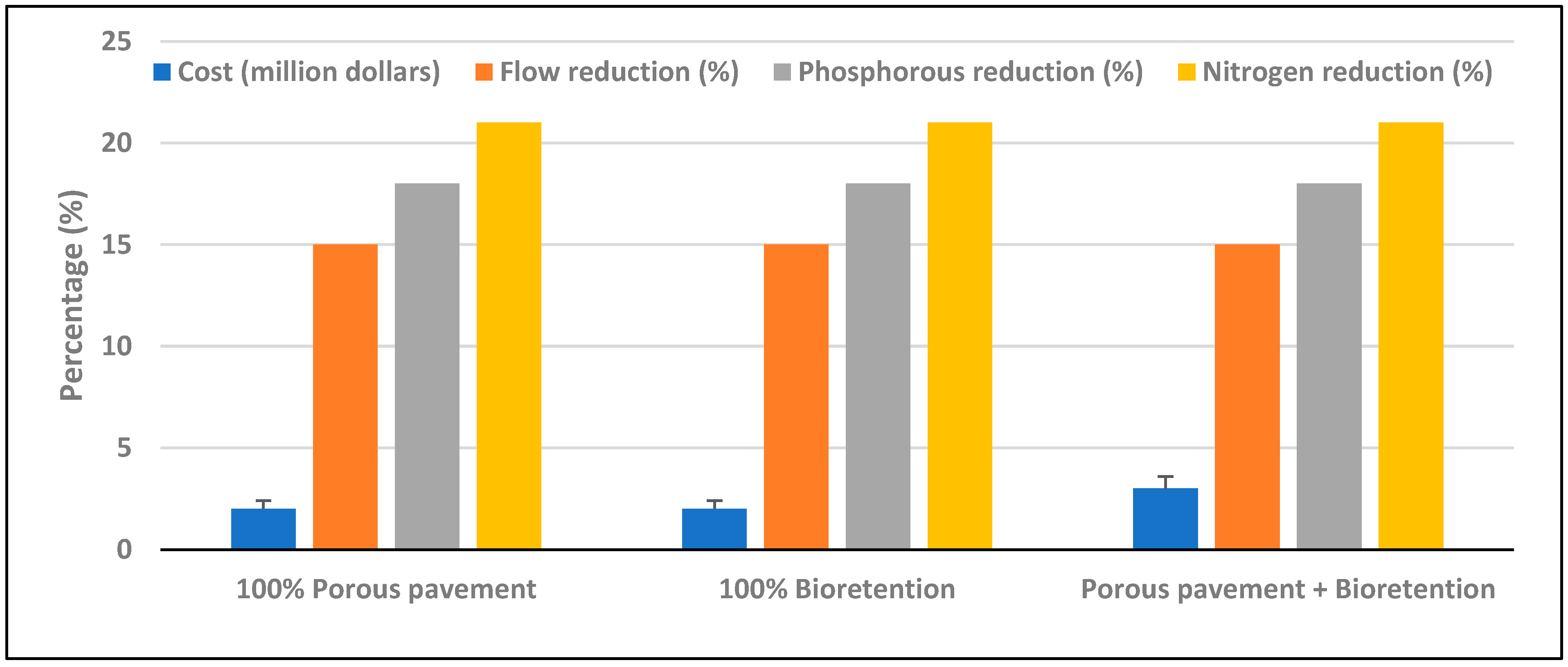
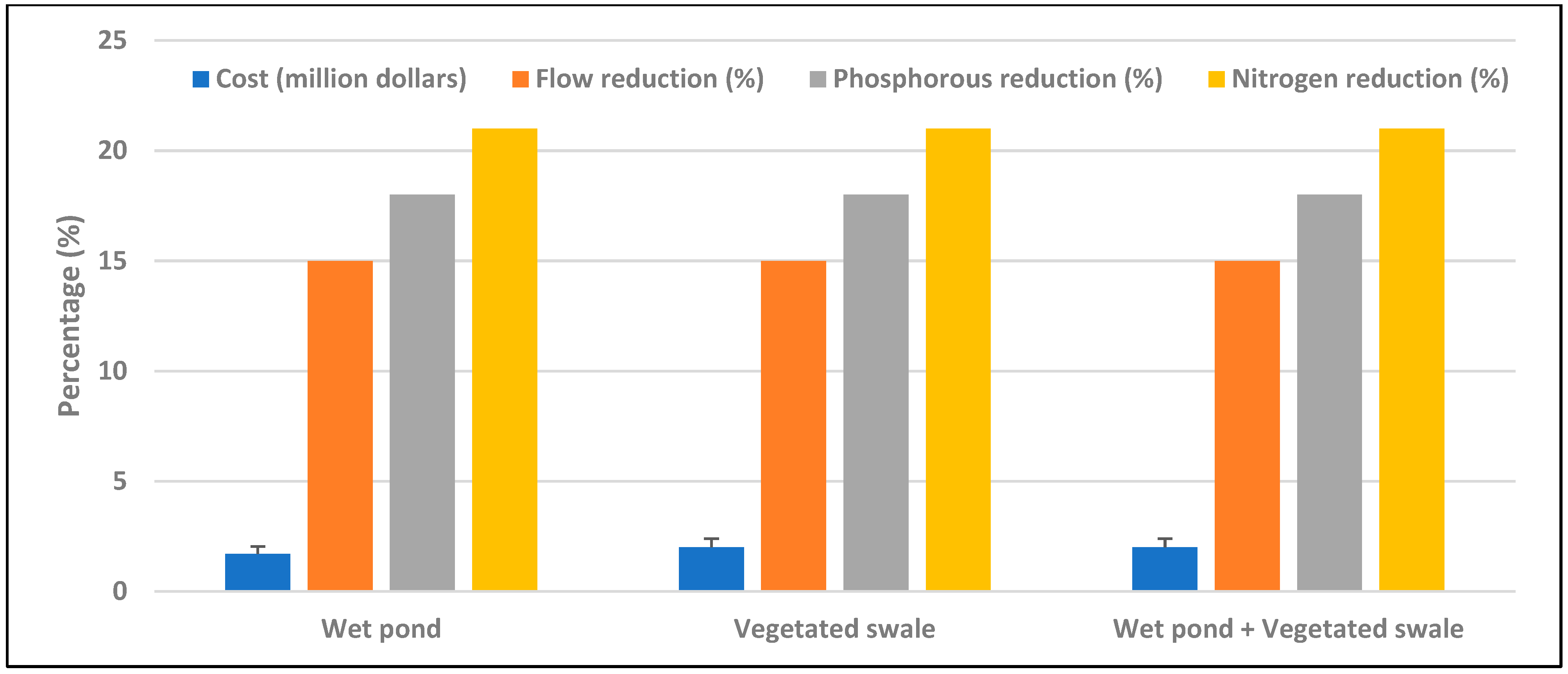
The results from this study indicate that the reduction of total phosphorus, total nitrogen, and runoff under current and future land use conditions can be achieved by using either treat and release or infiltration-based GI practices. Under the current (2018) land use, treat and release systems such as vegetated swales and wet ponds were the most cost-effective GI practices to achieve TMDL requirements at USD 1.5 million. However, vegetated swales only occupied 6 acres of land as opposed to 7 acres under wet ponds. Under the future land use change A1B scenario projections, both vegetated swales were cost-effective at USD 1.5 million. However, if land area is a constraint, then building bioretention cells at USD 2 million will be effective, given it only takes 3 acres of land compared to vegetated swales that will occupy 8 acres. Similarly, under B1 land use projections, porous pavements were the cost-effective solution at USD 1.5 million. These results are consistent with [
24] Gao et al. (2015), who used the SUSTAIN model and found the minimum costs to reduce Chemical Oxygen Demand (COD) by 40%, total nitrogen by 30%, and total phosphorus by 50% in the city of Ma’anshan, China, was of similar order in magnitude, at USD 3.96 million.
To restore the water quality of the Arroyo Colorado River to acceptable levels, it is pertinent that stakeholders prioritize reduction based on analysis of the future land use scenarios. If measures will be taken across the watershed for economic sustainability, it is recommended that infiltration-based GI practices (porous pavement) be considered under the B1 scenario of land use since it enables complete compliance with TMDL regulations for nitrogen and phosphorus by the year 2050 in a cost-effective manner. The costs required for nutrient reduction under the B1 land use scenario are slightly lower than those for the A1B scenario because holistic sustainability measures are enforced in the watershed to minimize the effects of projected land use change.
Under the A1B land use scenario, tradeoffs would have to be made since this scenario represents a situation in which there is rapid growth in technology, economic growth, and population until the mid-century and declines after the introduction of more efficient technologies, thus creating a balance between the use of fossil fuels and non-fossil fuel sources of energy. The introduction of more efficient technologies may have an impact on the management of both agricultural and urban watersheds, thus reducing the likelihood of flooding and water quality deterioration, but the impact could not be predicted here.
In addition, the results show that when a combination of stormwater management actions are implemented, such as residue management, irrigation BMPs, nutrient management, seasonal residue management, land leveling at the farm level, and urban BMPs in urban areas, the costs and number of BMPs required to meet TMDL targets significantly reduces. Therefore, it is important to note that such stormwater management actions are relatively cheaper and provide significant cost savings in the long run for local governments and cities. This is consistent with other studies such as [
15,
48,
49]. Cost analysis indicated that implementing a single BMP was relatively cheaper than implementing a combination of multiple BMPs to achieve the TMDL requirements. The mitigation costs under the future land use change scenarios were similar to those needed to achieve TMDL requirements under the current land use change. Most cost-effective strategies cost between USD 1.5 to 2 million, including other management practices, for water quality mitigation.
In terms of both reduced area and cost requirements, the use of bioretention cells is a feasible option to achieve TMDL targets. This can be attributed to the design of each bioretention cell with a filter material and pretreatment unit that removes excessive nutrients. The design of the bioretention systems in this study assumed that there is a pretreatment unit with filter material that removes some particulate phosphorus. In contrast, a portion of the dissolved phosphorus is assumed to be removed by the plants on the side slopes of the bioretention cell. The filter materials can be selected based on locally available cost-effective materials. For example, relatively coarser materials such as river rocks were effective in flood-prone areas for reducing stormwater flow and improving water quality [
41,
50,
51,
52]. This research proposes a combination of bioretention in urban areas and nutrient management in agricultural fields for the achievement of TMDL targets in the shortest time possible. This calls for a holistic approach between urban stakeholders and agricultural field owners in implementing the action items set forth in [
8].
This study provides valuable information for stakeholders and city managers to make decisions about implementing GI strategies in achieving TMDL requirements. There are some limitations of this study. For example, the future land use projection maps were resampled from 250 m to 30 m for implementing the models, which can induce some uncertainties in estimating land use change impacts. It is recommended that the combined effects of climate and land use, along with a lifecycle analysis, be studied for the Arroyo Colorado Watershed as well as other similar semi-arid watersheds to develop holistic approaches for the future. There is also uncertainty in the cost requirements for the different BMPs since the costs used to run the model were purely conservative to determine the minimum investment required by the cities in the watershed to achieve TMDL targets within the next 25–30 years. In the future, lifecycle assessment for GI practices can be assessed under different hydroclimatic settings. Given that the performance of GI practices can change with time and different maintenance schedules, such information can be modelled by updating different parameters of the GI practices over their life-spans. In addition, it will be interesting to study how changes in the magnitude and frequency of extreme events can affect the performance of the GI practices, which will be explored in the near future.


