

Regional Flood Risk Assessment and Prediction Based on Environmental Attributes and Pipe Operational Characteristics

Abstract
1. Introduction
2. Study Area and Data Sources
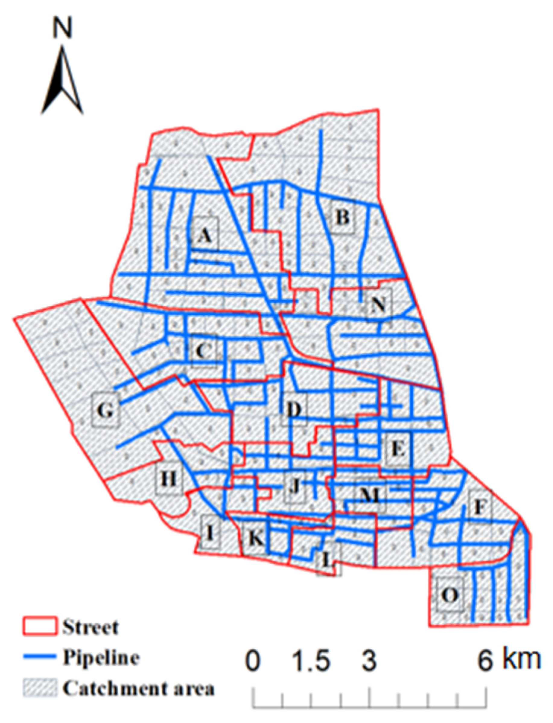
2.1. Study Area
2.2. Data Sources
3. Research Methods
3.1. Construction of Urban Flood Risk Evaluation System
3.1.1. Selection of Evaluation Indicators
3.1.2. Quantification of Evaluation Indicators
- (1)
- Quantification of Environmental Attribute Indicators
- 1
- Quantification of Pipe Network Operational Characteristics
- 2
- SWMM Construction
3.1.3. Flood Risk Calculation and Classification
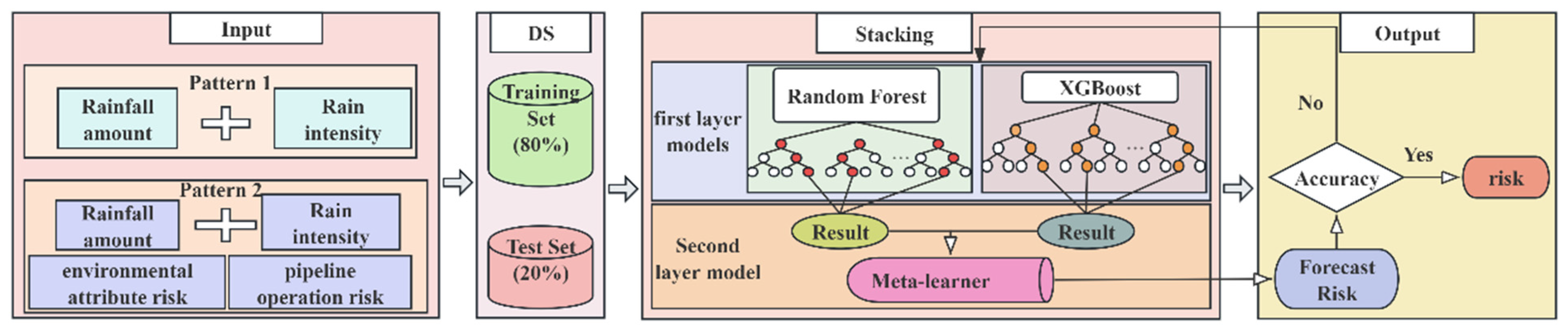
3.2. Construction of the Flood Risk Prediction Model
4. Analysis of the Results
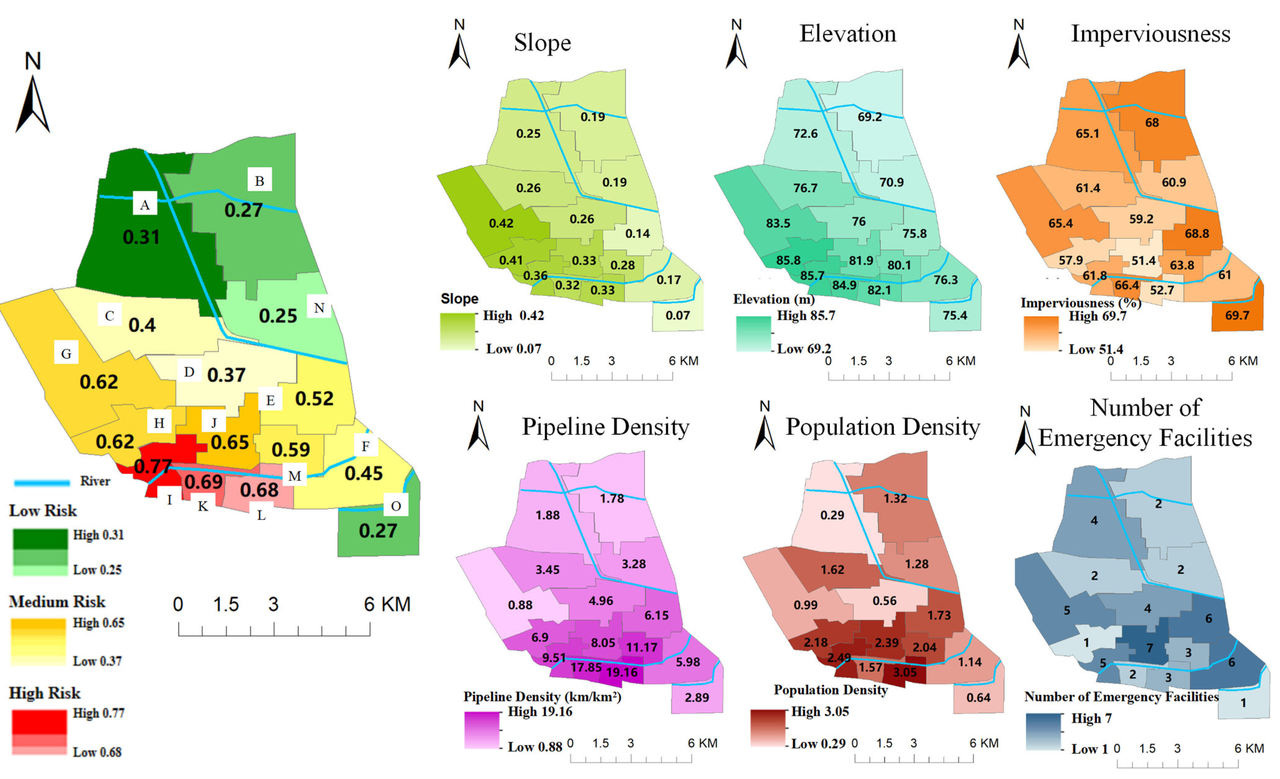
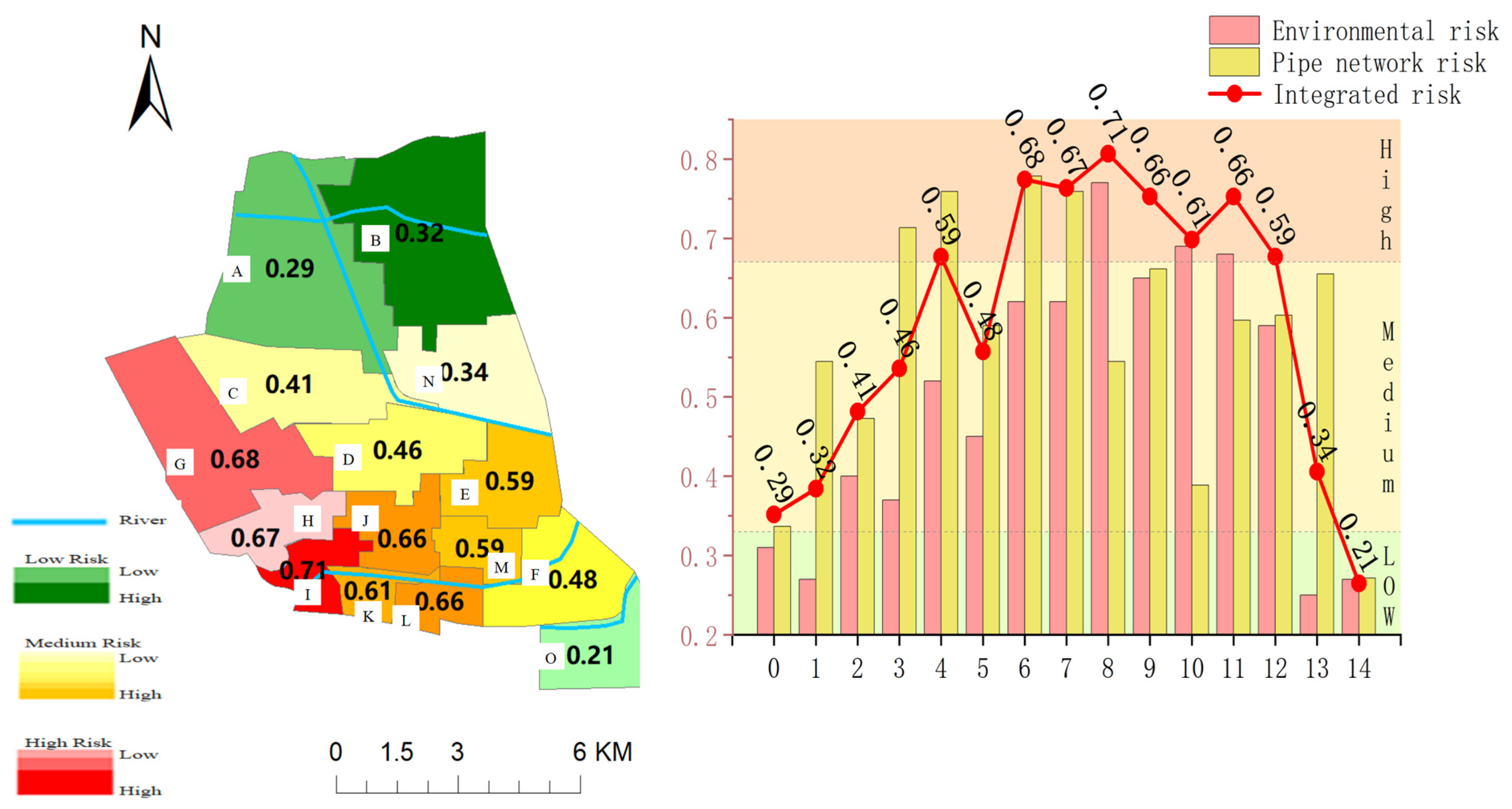
4.1. Urban Flood Risk Analysis
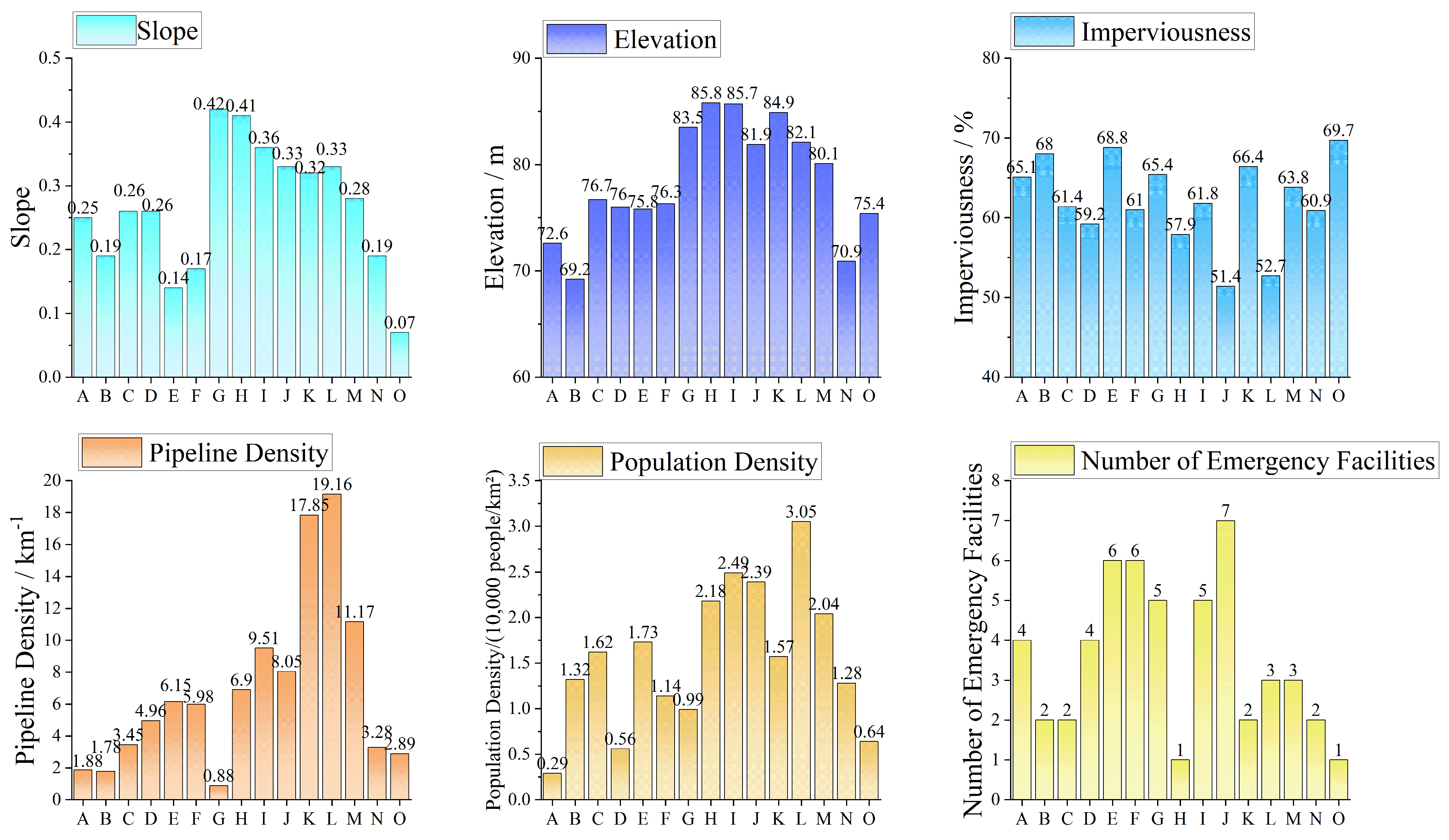
4.1.1. Environmental Attribute Risk
4.1.2. Pipeline Operation Characteristics Risk
4.1.3. Comprehensive Attribute Risk
4.2. Urban Flood Risk Prediction
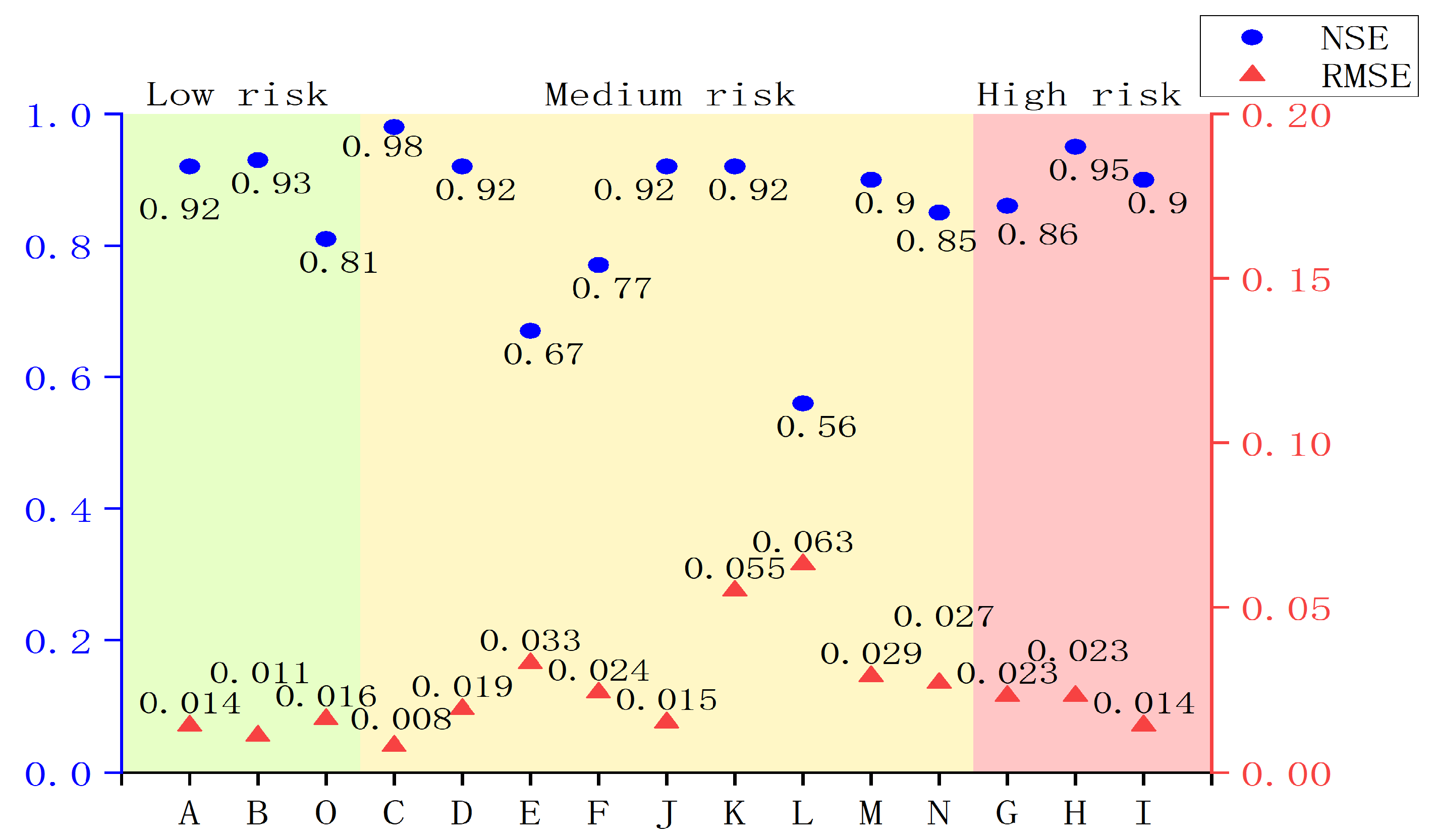
4.2.1. Prediction Model Evaluation
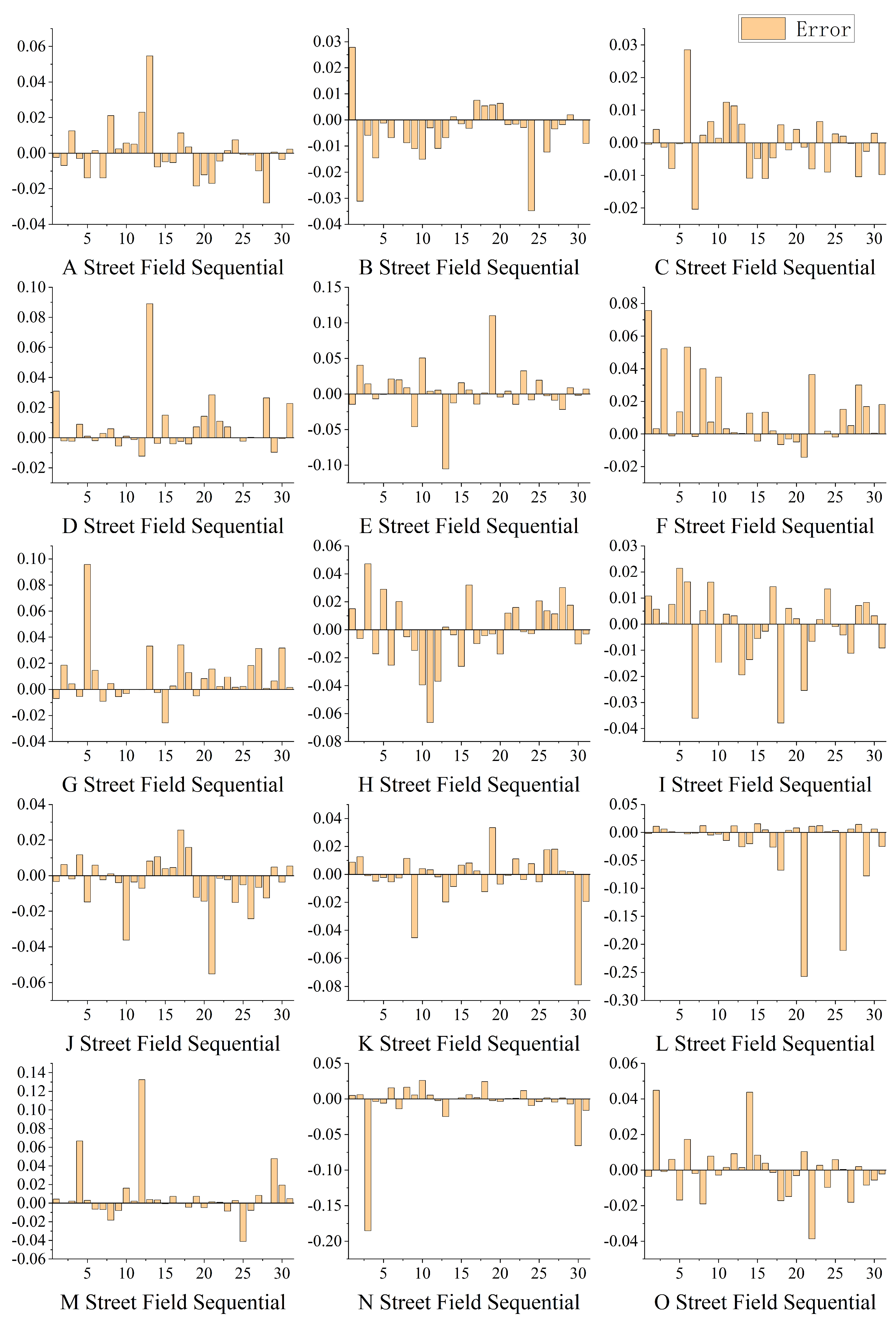
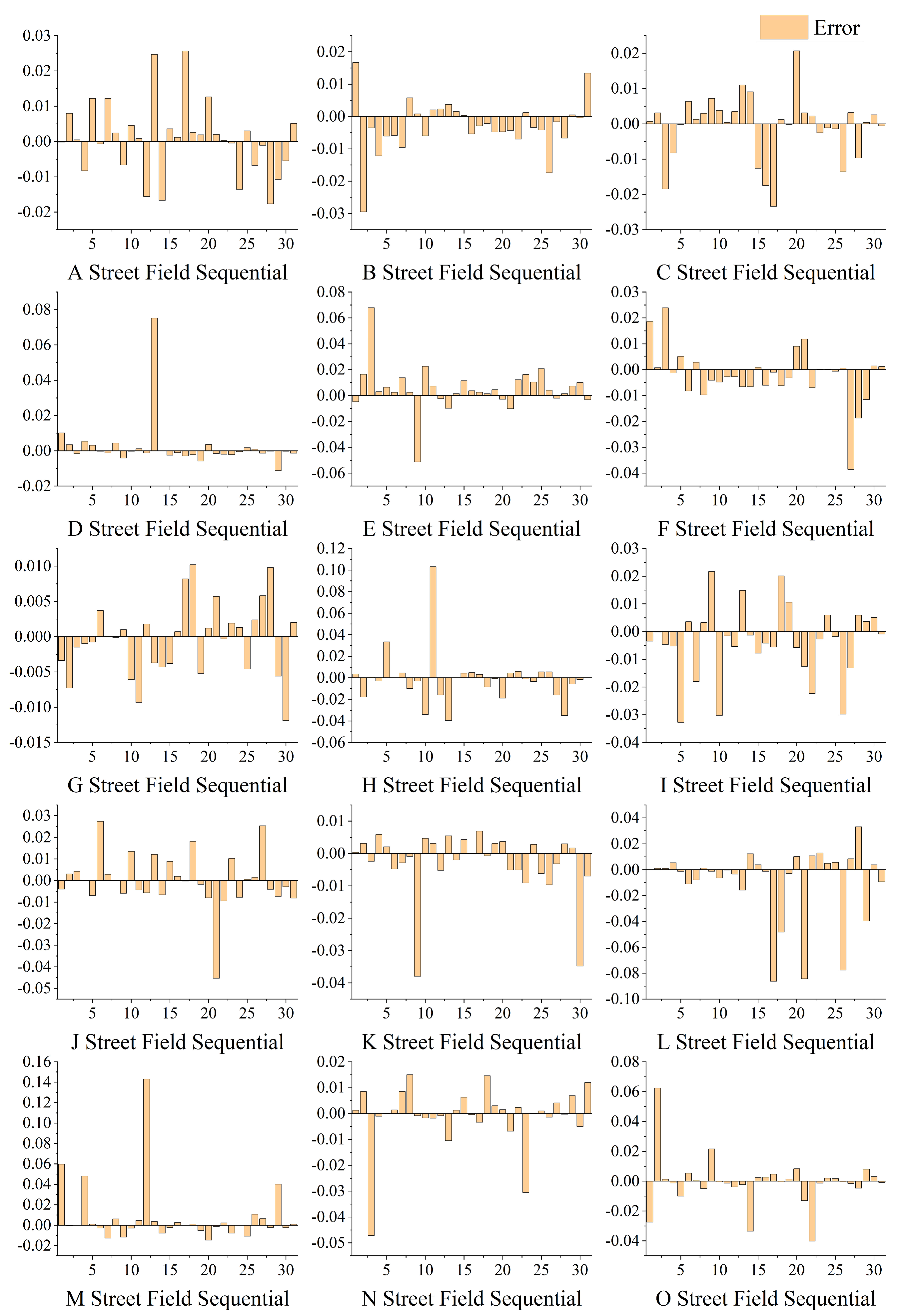
4.2.2. Comparison of Prediction Results
5. Discussion
6. Conclusions
- (1)
- The overall urban flood risk shows an increasing trend from northeast to southwest, with high-risk areas concentrated in the southwest. These areas are typically highly impermeable and have high pressure on their pipelines. Low-risk areas are located in regions with lower population densities and better pipe facilities.
- (2)
- Environmental attributes and pipeline operation characteristics influence urban flood risk. Relying solely on environmental attributes or pipeline operation characteristics for risk assessments may limit their utility. Introducing a model for the evaluation of pipeline operation characteristics based on environmental attributes enables a more reasonable risk assessment. Impermeability, slope, and population density are key environmental factors influencing regional flood characteristics and risk distribution. The pipe system’s operational status, influenced by upstream and downstream pipeline interactions, is an important medium for flood risk propagation. Additionally, rivers play a vital role in alleviating local waterlogging and regulating regional pipe pressure.
- (3)
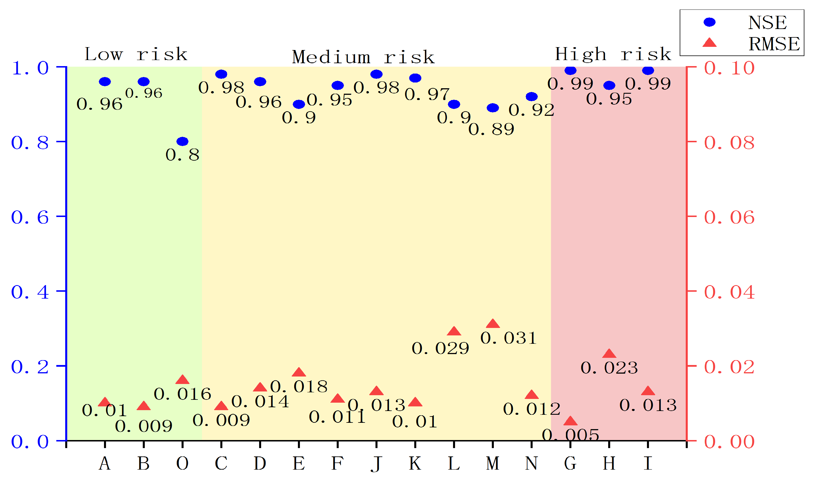
- The loosely coupled RF−XGBoost model improves prediction accuracy. In Pattern 1, where only rainfall characteristics are considered, the average Nash–Sutcliffe Efficiency is 0.85, demonstrating the model’s good prediction performance. In Pattern 2, which combines precipitation characteristics, environmental attributes, and pipeline operation characteristics, the model shows a higher prediction accuracy and robustness, with an average NSE of 0.94 and better RMSE values than those for Pattern 1. Comprehensive consideration of environmental attributes, pipeline operation characteristics, and meteorological conditions is key to improving urban flood risk prediction accuracy.
Author Contributions
Funding
Data Availability Statement
Conflicts of Interest
References
- Beltramone, G.; Alaniz, E.; Ferral, A.E.; Aleksinko, A.; Arijón, D.R.; Bernasconi, I.; German, A.; Ferral, A. Risk mapping of urban areas prone to flash floods in mountain basins using the analytic hierarchy process and geographical information systems. In Proceedings of the 2017 XVII Workshop on Information Processing and Control (RPIC), Mar del Plata, Argentina, 20 September 2017. [Google Scholar]
- Su, W.; Ye, G.; Yao, S.; Yang, G. Urban Land Pattern Impacts on Floods in a New District of China. Sustainability 2014, 6, 6488–6508. [Google Scholar] [CrossRef]
- Feyen, L.; Barredo, J.I.; Dankers, R. Implications of global warming and urban land use change on flooding in Europe. Water Urban Dev. Paradig. 2008, 3, 235–244. [Google Scholar]
- Dimitriou, E.; Efstratiadis, A.; Zotou, I.; Papadopoulos, A.; Iliopoulou, T.; Sakki, G.K.; Mazi, K.; Rozos, E.; Koukouvinos, A.; Koussis, A.D.; et al. Post-Analysis of Daniel Extreme Flood Event in Thessaly, Central Greece: Practical Lessons and the Value of State-of-the-Art Water-Monitoring Networks. Water 2024, 16, 980. [Google Scholar] [CrossRef]
- Wang, H.W.; Kuo, P.H.; Shiau, J.T. Assessment of climate change impacts on flooding vulnerability for lowland management in southwestern Taiwan. Nat. Hazards 2013, 68, 1001–1019. [Google Scholar] [CrossRef]
- Qi, H.; Altinakar, M.S. Simulation-based decision support system for flood damage assessment under uncertainty using remote sensing and census block information. Nat. Hazards 2011, 59, 1125–1143. [Google Scholar] [CrossRef]
- Song, T.X.; Liu, J.H.; Mei, C.; Zhang, M.X.; Wang, H.; Nazli, S. Coupling effect analysis of dam break flood spread and building collapse based on numerical simulation. Sci. China Technol. Sci. 2024, 67, 3571–3584. [Google Scholar] [CrossRef]
- Li, Y.; Han, H.; Sun, Y.; Xiao, X.; Liao, H.; Liu, X.; Wang, E. Risk Evaluation of Ice Flood Disaster in the Upper Heilongjiang River Based on Catastrophe Theory. Water 2023, 15, 2724. [Google Scholar] [CrossRef]
- Ying, X.; Ni, T.; Lu, M.; Li, Z.; Lu, Y.; Bamisile, O. Urban Flooding Risk Assessment Based on Numerical Simulation of Sub-catchment Area: A Case Study From Chengdu, China. Res. Sq. 2021. [Google Scholar] [CrossRef]
- Merz, B.; Aerts, J.; Arnbjerg-Nielsen, K.; Baldi, M.; Nied, M. Floods and climate: Emerging perspectives for flood risk assessment and management. Nat. Hazards Earth Syst. Sci. 2014, 14, 1921–1942. [Google Scholar] [CrossRef]
- Mustafa, A.; Bruwier, M.; Archambeau, P.; Erpicum, S.; Pirotton, M.; Dewals, B.; Teller, J. Effects of spatial planning on future flood risks in urban environments. J. Environ. Manag. 2018, 225, 193–204. [Google Scholar] [CrossRef]
- Kim, G.; Cho, H.T. Development of an Urban Flood Forecast Model Using Lumped Pipe Networks. J. Korean Soc. Hazard Mitig. 2022, 22, 79–88. [Google Scholar] [CrossRef]
- Ren, Y.; Zhang, H.; Wang, X.; Gu, Z.; Fu, L.; Cheng, Y. Optimized Design of Sponge-Type Comprehensive Pipe Corridor Rainwater Chamber Based on NSGA-III Algorithm. Water 2023, 15, 3319. [Google Scholar] [CrossRef]
- Zhu, J.; Zhou, W.; Yu, W.; Wang, W. Block-level spatial integration of population density, social vulnerability, and heavy precipitation reveals intensified urban flooding risk. Sustain. Cities Soc. 2024, 117, 105984. [Google Scholar] [CrossRef]
- Adams, R.; Rees, P.L.; Bedient, P.B.; Vieux, B.E. Improved Flood Prediction in an Urban Watershed Using a Physically-Based Modeling Approach. AGU Spring Meet. Abstr. 2005, 2005, H21C-03. [Google Scholar]
- Xudong, Z.; Kun, Y.; Shuangyun, P.; Quanli, X.; Chao, M. The study of urban rainstorm waterlogging scenario simulation based on GIS and SWMM model—Take the example of Kunming Dongfeng East Road catchment area. In Proceedings of the International Conference on Geoinformatics, Kaifeng, China, 20–22 June 2013. [Google Scholar]
- Ahmed, N.S. Machine Learning Models for Pavement Structural Condition Prediction: A Comparative Study of Random Forest (RF) and eXtreme Gradient Boosting (XGBoost). Open J. Civ. Eng. 2024, 14, 17. [Google Scholar] [CrossRef]
- Quanlong, F.; Jiantao, L.; Jianhua, G. Urban Flood Mapping Based on Unmanned Aerial Vehicle Remote Sensing and Random Forest Classifier—A Case of Yuyao, China. Water 2015, 7, 1437–1455. [Google Scholar] [CrossRef]
- Lee, S.; Kim, J.C.; Jung, H.S.; Lee, M.J.; Lee, S. Spatial prediction of flood susceptibility using random-forest and boosted-tree models in Seoul metropolitan city, Korea. Geomat. Nat. Hazards Risk 2017, 8, 1185–1203. [Google Scholar] [CrossRef]
- Hitouri, S.; Mohajane, M.; Lahsaini, M.; Ali, S.A.; Setargie, T.A.; Tripathi, G.; D’Antonio, P.; Singh, S.K.; Varasano, A. Flood Susceptibility Mapping Using SAR Data and Machine Learning Algorithms in a Small Watershed in Northwestern Morocco. Remote Sens. 2024, 16, 858. [Google Scholar] [CrossRef]
- Auret, L.; Aldrich, C. Interpretation of nonlinear relationships between process variables by use of random forests. Miner. Eng. 2012, 35, 27–42. [Google Scholar] [CrossRef]
- Aydn, Y.; Nigdeli, S.M.; Bekda, G. Determination of the Effect of XGBoost’s Parameters on a Structural Problem; Springer: Cham, Switzerland, 2024; pp. 319–339. [Google Scholar]
- Jialei, C.; Guoru, H.; Wenjie, C. Towards better flood risk management: Assessing flood risk and investigating the potential mechanism based on machine learning models. J. Environ. Manag. 2021, 293, 112810. [Google Scholar]
- Zhang, J.; Wang, Y.; He, R.; Hu, Q.; Song, X. Discussion on the urban flood and waterlogging and causes analysis in China. Adv. Water Sci. 2016, 27, 485–491. [Google Scholar]
- Leitao, J.P. Enhancement of Digital Elevation Models and Overland Flow Path Delineation Methods for Advanced Urban Flood Modelling. Ph.D. Thesis, Imperial College London, South Kensington, London, UK, 2009. [Google Scholar]
- Wang, C. Urban flood risk analysis for determining optimal flood protection levels based on digital terrain model and flood spreading model. Vis. Comput. 2010, 26, 1369–1381. [Google Scholar] [CrossRef]
- Pedersen, A.N.; Mikkelsen, P.S.; Arnbjerg-Nielsen, K. Climate change-induced impacts on urban flood risk influenced by concurrent hazards. J. Flood Risk Manag. 2012, 5, 203–214. [Google Scholar] [CrossRef]
- Xu, K.; Tian, Y.; Bin, L.; Xu, H.; Xue, X.; Lian, J. Analysis of Urban Flooding Driving Factors Based on Water Tracer Method and Optimal Parameters-Based Geographical Detector. Int. J. Disaster Risk Sci. 2025, 16, 276–290. [Google Scholar] [CrossRef]
- Yuan, D.; Xue, H.; Du, M.; Pang, Y.; Wang, J.; Wang, C.; Song, X.; Wang, S.; Kou, Y. Urban waterlogging resilience assessment based on combination weight and cloud model: A case study of Haikou. Environ. Impact Assess. Rev. 2025, 111, 107728. [Google Scholar] [CrossRef]
- Xiangyu, C.; Guangheng, N.; Shibo, H.; Fuqiang, T.; Tong, Z. Simulative analysis on storm flood in typical urban region of Beijing based on SWMM. Water Resour. Hydropower Eng. 2006, 37, 64–67. [Google Scholar]
- Jiang, L.; Chen, Y.; Wang, H. Urban flood simulation based on the SWMM model. Proc. IAHS 2015, 368, 186–191. [Google Scholar] [CrossRef]
- Bisht, D.S.; Chatterjee, C.; Kalakoti, S.; Upadhyay, P.; Sahoo, M.; Panda, A. Modeling urban floods and drainage using SWMM and MIKE URBAN: A case study. Nat. Hazards 2016, 84, 749–776. [Google Scholar] [CrossRef]
- Yu, H.; Huang, G.; Wu, C. Application of the stormwater management model to a piedmont city: A case study of Jinan City, China. Water Sci. Technol. A J. Int. Assoc. Water Pollut. Res. 2014, 70, 858–864. [Google Scholar] [CrossRef]
- Yuqing, T.; Qiming, C.; Fengwei, L.; Fei, L.; Linhao, L.; Yihong, S.; Shaochun, Y.; Wenyu, X.; Zhen, L.; Yao, C. Hydrological reduction and control effect evaluation of sponge city construction based on one-way coupling model of SWMM-FVCOM: A case in university campus. J. Environ. Manag. 2024, 349, 119599. [Google Scholar]
- Gall, J.; Razavi, N.; Gool, L.V. An Introduction to Random Forests for Multi-class Object Detection; Springer: Berlin/Heidelberg, Germany, 2012; pp. 243–263. [Google Scholar]
- Joshi, A.; Vishnu, C.; Mohan, C.K.; Raman, B. Application of XGBoost model for early prediction of earthquake magnitude from waveform data. J. Earth Syst. Sci. 2024, 133, 5. [Google Scholar] [CrossRef]
- Camarasa-Belmonte, A.M.; Soriano-García, J. Flood risk assessment and mapping in peri-urban Mediterranean environments using hydrogeomorphology. Application to ephemeral streams in the Valencia region (eastern Spain). Landsc. Urban Plan. 2012, 104, 189–200. [Google Scholar] [CrossRef]
- Muthu, K.; Ramamoorthy, S. Urban flood risk assessment using fuzzy logic and real-time flood simulation model—A geomatics techniques. Earth Sci. Inform. 2024, 18, 72. [Google Scholar] [CrossRef]
- Leandro, J.; Chen, A.S.; Djordjevic, S.; Savic, D.A. Comparison of 1D/1D and 1D/2D Coupled (Sewer/Surface) Hydraulic Models for Urban Flood Simulation. J. Hydraul. Eng. 2009, 135, 495–504. [Google Scholar] [CrossRef]
- Viavattene, C.; Ellis, J.B. The management of urban surface water flood risks: SUDS performance in flood reduction from extreme events. Water Sci. Technol. A J. Int. Assoc. Water Pollut. Res. 2013, 67, 99–108. [Google Scholar] [CrossRef]
- Kumar, K.L.; Sirisati, R.S. Development and Comparative Analysis of Advanced Machine Learning Algorithms for Flood Prediction and Susceptibility Mapping. Neuro Quantology 2024, 22, 201–214. [Google Scholar]


| Data Name | Explanation | Source |
|---|---|---|
| Rainfall data | 10 min raster data (2018–2022) | Zhengzhou Meteorological Bureau |
| DEM data with elevation data | accuracy of 12.5 m (2023) | ZhongKetusin (http://www.tuxingis.com) |
| Pipe network data | Zhengzhou pipe engineering pipe network map | Zhengzhou Municipal Administration Office |
| Land use data | ESA resolution of 10 m for land use data, including woodland, grassland, cultivated land, and buildings | European Space Agency (https://esa-worldcover.org/en) |
| Social and economic data | Includes population density, pipeline network density, and the number of emergency facilities | Zhengzhou Bureau of Statistics |
| Evaluation Content | Primary Indicators | Secondary Indicators | Tertiary Indicators |
|---|---|---|---|
| Urban Flood Risk Evaluation | Environmental Attributes | Natural Attributes | Slope |
| Elevation | |||
| Impervious Surface Ratio | |||
| Socio-economic Attributes | Pipeline Density | ||
| Population Density | |||
| Number of Emergency Facilities | |||
| Pipe Network Operational Characteristics | Node Risk | Overflow Volume | |
| Ponding Duration | |||
| Maximum Ponding Depth | |||
| Pipeline Risk | Overload Duration | ||
| Maximum Flow | |||
| Maximum Velocity |
| Indicators | Weight (%) | Indicators | Weight (%) |
|---|---|---|---|
| Slope | 13.4 | Overflow Volume | 5.5 |
| Elevation | 8.4 | Ponding Duration | 7.9 |
| Impervious Surface Ratio | 11.8 | Maximum Ponding Depth | 6.6 |
| Pipeline Density | 8.3 | Overload Duration | 6.3 |
| Population Density | 12.6 | Maximum Flow | 4.7 |
| Number of Emergency Facilities | 10.1 | Maximum Velocity | 4.3 |
| Return Period of Rainfall | Surface Runoff Continuity Error | Flow Calculation Continuity Error | Comprehensive Runoff Coefficient |
|---|---|---|---|
| 1a | −0.08% | −0.09% | 0.633 |
| 2a | −0.06% | 0.03% | 0.687 |
| 5a | −0.02% | −0.71% | 0.652 |
| Risk Value | Risk Level |
|---|---|
| <0.33 | Low Risk |
| 0.33–0.67 | Medium Risk |
| >0.67 | High Risk |
Disclaimer/Publisher’s Note: The statements, opinions and data contained in all publications are solely those of the individual author(s) and contributor(s) and not of MDPI and/or the editor(s). MDPI and/or the editor(s) disclaim responsibility for any injury to people or property resulting from any ideas, methods, instructions or products referred to in the content. |
© 2025 by the authors. Licensee MDPI, Basel, Switzerland. This article is an open access article distributed under the terms and conditions of the Creative Commons Attribution (CC BY) license (https://creativecommons.org/licenses/by/4.0/).
Share and Cite
Zhang, J.; Yang, Y.; Zhang, L.; Zhang, X.; Wang, Y. Regional Flood Risk Assessment and Prediction Based on Environmental Attributes and Pipe Operational Characteristics. Water 2025, 17, 1477. https://doi.org/10.3390/w17101477
Zhang J, Yang Y, Zhang L, Zhang X, Wang Y. Regional Flood Risk Assessment and Prediction Based on Environmental Attributes and Pipe Operational Characteristics. Water. 2025; 17(10):1477. https://doi.org/10.3390/w17101477
Chicago/Turabian StyleZhang, Jinping, Yirong Yang, Lixin Zhang, Xi Zhang, and Yao Wang. 2025. "Regional Flood Risk Assessment and Prediction Based on Environmental Attributes and Pipe Operational Characteristics" Water 17, no. 10: 1477. https://doi.org/10.3390/w17101477
APA StyleZhang, J., Yang, Y., Zhang, L., Zhang, X., & Wang, Y. (2025). Regional Flood Risk Assessment and Prediction Based on Environmental Attributes and Pipe Operational Characteristics. Water, 17(10), 1477. https://doi.org/10.3390/w17101477