Article

Analysis of the Projected Climate Impacts on the Interlinkages of Water, Energy, and Food Nexus Resources in Narok County, Kenya, and Vhembe District Municipality, South Africa

by
Nosipho Zwane
1,2,*,
Joel O. Botai
2,
Siyabonga H. Nozwane
1,
Aphinda Jabe
3,
Christina M. Botai
1,
Lucky Dlamini
1,
Luxon Nhamo
4,5,
Sylvester Mpandeli
5,6,
Brilliant Petja
5,
Motochi Isaac
7 and
Tafadzwanashe Mabhaudhi
4,8,9,*
1
South African Weather Service, Private Bag X097, Pretoria 0001, South Africa
2
Department of Geography, Geoinformatics and Meteorology, University of Pretoria, Private Bag X020, Hatfield, Pretoria 0028, South Africa
3
Just Share NPC, Plum Park, 25 Gabriel Road, Plumstead, Cape Town 7800, South Africa
4
Centre for Transformative Agricultural and Food Systems, School of Agriculture, Earth and Environmental Sciences, University of KwaZulu-Natal, Pietermaritzburg 3209, South Africa
5
Water Research Commission of South Africa, Lynnwood Bridge, Pretoria 0082, South Africa
6
Department of Environmental, Water and Earth Sciences, Tshwane University of Technology, Pretoria 0002, South Africa
7
Department of Mathematics and Physical Sciences, Maasai Mara University, Narok P.O. Box 861-20500, Kenya
8
Centre on Climate Change and Planetary Health, London School of Hygiene & Tropical Medicine, London WC1E 7HT, UK
9
United Nations University Institute for Water, Environment and Health (UNU-INWEH), Richmond Hill, ON L4B 3P4, Canada
*
Authors to whom correspondence should be addressed.
Water 2025, 17(10), 1449; https://doi.org/10.3390/w17101449 (registering DOI)
Submission received: 14 March 2025 / Revised: 30 April 2025 / Accepted: 8 May 2025 / Published: 11 May 2025

Abstract

:
The current changing climate requires the development of water–energy–food (WEF) nexus-oriented systems capable of mainstreaming climate-smart innovations into resource management. This study demonstrates the cross-sectoral impacts of climate change on interlinked sectors of water, energy, and food in Narok County, Kenya, and Vhembe District, South Africa. This study used projected hydroclimatic extremes across past, present, and future scenarios to examine potential effects on the availability and accessibility of these essential resources. The projected temperature and rainfall are based on nine dynamically downscaled Coupled Model Intercomparison Project Phase 5 (CMIP 5) of the Global Climate Models (GCMs). The model outputs were derived from two IPCC “Representative Concentration Pathways (RCPs)’’, the RCP 4.5 “moderate scenario”, and RCP 8.5 “business as usual scenario”, also defined as the addition of 4.5 W/m2 and 8.5 W/m2 radiative forcing in the atmosphere, respectively, by the year 2100. For the climate change projections, outputs from the historical period (1976–2005) and projected time intervals spanning the near future, defined as the period starting from 2036 to 2065, and the far future, spanning from 2066 to 2095, were considered. An ensemble model to increase the skill, reliability, and consistency of output was formulated from the nine models. The statistical bias correction based on quantile mapping using seven ground-based observation data from the South African Weather Services (SAWS) for Limpopo province and nine ground-based observation data acquired from the Trans-African Hydro-Meteorological Observatory (TAHMO) for Narok were used to correct the systematic biases. Results indicate downscaled climate change scenarios and integrate a modelling framework designed to depict the perceptions of future climate change impacts on communities based on questionnaires and first-hand accounts. Furthermore, the analysis points to concerted efforts of multi-stakeholder engagement, the access and use of technology, understanding the changing business environment, integrated government and private sector partnerships, and the co-development of community resilience options, including climate change adaptation and mitigation in the changing climate. The conceptual climate and WEF resource modelling framework confirmed that future climate change will have noticeable interlinked impacts on WEF resources that will impact the livelihoods of vulnerable communities. Building the resilience of communities can be achieved through transformative WEF nexus solutions that are inclusive, sustainable, equitable, and balance adaptation and mitigation goals to ensure a just and sustainable future for all.

1. Introduction

The security of water, energy, and food is a key priority as the three resources are stressed globally due to the recurrence of extreme weather events, depletion, degradation, and increasing demand from a growing population [1]. The three sectors (water, energy, and food) are intricately interconnected as energy generation requires water in large volumes for fuel production, mining, hydropower, and power plant cooling [2]. On the other hand, energy is also needed for pumping, treating, and distributing water and collecting, treating, and discharging wastewater [3]. Simultaneously, water and energy are needed for food production, while crops such as maize, soybean, and sugarcane are now found to have alternative biofuel uses [4]. These mutual interconnections are referred to as the water–energy–food (WEF) nexus.
The African continent is experiencing heightened competition among communities for these key resources [1,2]. The relationship between water–energy–food (WEF) resources and the African economies has become increasingly significant as the continent faces increased competition for these critical resources among communities [3]. The continent faces multiple stresses, including a poor economy, threats posed by climate change, poor governance, and the lack of a recovery strategy after the COVID-19 pandemic. Since the WEF nexus underpins sustainable development goals (SDGs), particularly Goals 2, 6, 7, and 13, numerous studies have been undertaken in Africa. A study conducted by Molefe and Inglesi [3] investigated the variable relationship between water, energy, food, and economic conditions for five African countries, namely, South Africa, Nigeria, Kenya, Angola, and Ethiopia. Molefe and Inglesi [3] explained the significance of WEF interlinkages while acknowledging the increasing demand for the three resources due to the increasing population and changing lifestyles on dietary requirements. The findings showed synergies between the three sustainability demonstrations for the five countries, which have important policy implications for the continent’s current and future developmental conditions.
In Kenya, Wakeford [4] examined the global and national effects of the WEF nexus, such as population growth and rapid urbanisation. Moreover, the study identified Kenya’s WEF vulnerabilities and risks, including climate variability and international food and oil price consternation. Meanwhile, Kanda et al. [5] analysed the policy interventions aligned with WEF resources and underscored that, while policies are in place, there is a need for more coordinated approaches across sectors.
An article by Yupanqui et al. [6] reviews the existing WEF nexus frameworks and models, underscoring their challenges and gaps. The WEF nexus provides a powerful tool for policymakers to drive sustainable resource management and achieve progress toward the SDGs, specifically 2, 6, 7, 8, and 13. Moreover, David et al. [7] explored WEF resource management in South Africa, advocating for a digital framework to support development and results across these sectors.
These studies collectively identify common challenges, such as policy misalignment, sector-specific silos or linear approaches, resource misallocation, and inefficiencies, while advocating for an integrated policy framework, cross-sector collaboration, stakeholder engagement, improved governance, and investment in infrastructure and technology. The growing population in Africa is driving an increased demand for water, energy, and food resources [3]. According to Botai et al. [8], the climate crisis will likely increase the demand for these resources. A study by Zwane et al. [9] introduced the structural equation model as an innovative methodology over a single equation modelling framework in analysing variables that have complex interrelationships, facilitating advanced WEF nexus resource governance. The analysis concluded with high confidence that, while the food, energy, and water sectors are closely related, their effects on sustainability and the environment differ.
According to the Sixth Assessment Report of the Intergovernmental Panel on Climate Change [10], the global surface temperatures during the first two decades of the 21st century (2001–2020) were about 1 °C higher than the pre-industrial period (1850–1900). Notably, since 1970, the increase in global surface temperatures has been more rapid than in other 50-year periods over the preceding two millennia. This increase in average temperature has been linked to intensified extreme weather events such as heatwaves, wildfires, and droughts [11].
Specifically in South Africa, studies have alluded to increased minimum and maximum temperatures [12,13] and record-high temperatures consistent with global warming [14]. In Kenya, it has been observed that climate risks pose a significant threat to Kenya’s sustainable development goals, particularly because the economy of Kenya is largely dependent on rainfed agriculture and tourism, both of which are susceptible to extreme weather events attributed to climate variability and change [15]. Research has also demonstrated that erratic rainfall and increased drought have reduced agricultural productivity, water scarcity, and food insecurity in many areas of Kenya [16]. Similarly, extreme weather events such as floods and heat waves impact the tourism sector by affecting wildlife ecosystems and the infrastructure necessary for tourism [17]. Such problems require integrated policies and adaptive strategies to reduce risks and promote resilience in major economic sectors.
Africa is highly vulnerable to climate change because of its low adaptive capacity, limited technological access, and high sensitivity to climatic factors [17]. These climate-related hazards often lead to the loss of life, social disruption, and economic hardships [8]. In South Africa, an extreme heatwave occurred in January 2022 in the Northern Cape Province, where temperatures reached 41 °C [8]. The heatwave caused heatstroke-related deaths of seven farm workers. Additionally, the country faces highly variable rainfall patterns and more severe storms [8]. Extreme flooding caused the death of over 400 people in 2022 in KwaZulu-Natal Province, apart from damaging property and infrastructure. Water supply has been severely impacted by the recent severe drought in several regions, particularly the Western and Eastern Cape provinces [18,19,20]. The intensity and frequency of droughts and floods are taking a huge toll on the national economy.
In 2024, Kenya reported heavy rains that damaged crops and infrastructure and caused deaths in 33 of the 47 counties [12]. According to Molefe and Inglesi [3], climate change has been associated with a decrease in the likelihood of rainfall and a rise in its intensity, leading to an increased frequency of flooding, posing a significant threat to Kenya and South Africa’s food and water security, human health, economy, society, and environment [21]. Prolonged drought has caused severe famine, leaving over 10 million people facing starvation, while floods and the resurgence of pests and diseases have been noted in other parts of the country [22]. The interconnectedness of these systems underlines the need to adopt integrated resource management and adaptive strategies focused on regional specifics in climate and socio-economic conditions [22]. Given that climate projections indicate the increased frequency and intensity of these extreme weather conditions, comprehensive policies are needed to balance synergies and trade-offs from a WEF nexus perspective, enabling sustainable development and enhancing the resilience and adaptation of vulnerable communities [12].
Furthermore, climate change has increased the vulnerability of communities in Narok County and Vhembe District Municipality through unstable changes in meteorological variables, with many rural livelihoods dependent on agriculture and natural resources [23]. The prolonged drought and heavy rainfall combined have broken the fragile equilibrium that enhances water shortages and decreases agricultural production, adding to food insecurity [24]. Climate change strains the economic sector of local economies and heightens social issues such as displacement, migration, and resource conflicts [25].
The WEF resources are closely linked, with changes in one often affecting the others. Water is crucial for food production, and a shortage can result in crop failure and food insecurity. Similarly, energy is required for water extraction, treatment, and distribution. Therefore, disruption in the energy supply can limit water access. Lastly, food production relies heavily on energy for farming, transportation, and storage. Thus, energy shortages can decrease agricultural productivity. A decrease or shortage in any of these resources can cause cascading impacts, leading to more strain on the others. Hence, managing WEF resources in an integrated manner is crucial to addressing the challenges posed by climate change and ensuring resilient communities [24,25].
This study illustrates how climate change would affect the WEF resources in Narok County (Kenya) and Vhembe District Municipality (South Africa) in a business-as-usual scenario. This was achieved by analysing the potential effects of projected hydroclimatic extremes of past, present, and future water, energy, and food availability and access. This study, therefore, (a) illustrates the statistically downscaled climate change scenarios for annual surface temperature and annual total rainfall as well as the two extreme indices (Consecutive Dry Days and Simple Daily Intensity Index), (b) incorporates a modelling framework designed to depict the perceptions of future climate change impacts on communities based on questionnaires and first-hand counts. The framework is designed to be future-oriented, integrating climate projections to ensure proactive planning and resilience. Moreover, developing accurate climate scenarios requires a strong understanding of the baseline climate impacts. This entails gathering insights from respondents who have experienced climate-related changes first-hand. Their viewpoints offer valuable qualitative and quantitative data on past and present trends, vulnerabilities, and adaptive responses. Examining these interconnections, this study will shed light on the challenges and opportunities involved in devising integrated, sustainable strategies that enhance resilience and protect these vital resources in an uncertain climate.

2. Materials and Methods

2.1. Description of the Study Sites (VDM and Narok County)

The study by Botai et al. [8] describes the detailed geographical location and climatic and economic features of VDM and Narok County. As shown in this study, VDM is situated in the Limpopo Water Management Area in the northernmost region of Limpopo, South Africa. It is part of the larger Limpopo River Basin, which is shared by neighbouring countries (Zimbabwe, Mozambique, and Botswana). The VDM has a subtropical climate with 500 mm of annual rainfall on average, which occurs mostly from October to March. Temperatures can be as high as 40 °C and can reach lows of 10 °C, making the region prone to extreme weather conditions. The VDM is characterised by its varied topography, which includes Makuya Park and Kruger National Park. These natural resources make the area vital for conservation and community livelihood. The region faces recurrent environmental and extreme weather challenges such as droughts, floods, and fires, especially in the semi-arid Thulamela and Musina Local Municipalities.
Narok County in Kenya is in the Rift Valley and is known for its Maasai culture, wildlife, tourism, and agriculture. Narok County has a population of about 1.1 million and a total area of 17,921 km2. The county is home to Maasai Mara National Reserve, well known for the Great Wildebeest Migration, the Mau Forest, and Suswa Crater. Agriculture (mostly wheat and barley), tourism, and animal rearing are the economy’s main drivers. The climate of Narok County is temperate to semi-arid, with temperatures between 10 °C and 28 °C. The region has two rainy seasons and two dry seasons: (March–May and October–December) and (June–September and January–February), respectively. The rainfall varies between 500 mm and 1800 mm a year, with highlands cooler and wetter. Meanwhile, lowlands like the Maasai Mara are warmer and drier. Although there are sporadic droughts, the climate is conducive to farming, pastoralism, and wildlife [8].

2.2. Bias Correction Approach

The projected temperature and rainfall presented in this study are based on the Coupled Model Intercomparison Project Phase 5 (CMIP 5) Global Climate Models (GCMs) with specific focus on the selected projected greenhouse gas concentration pathways, also used as basis in the South African Weather Service (SAWS) Climate Change Atlas (https://www.weathersa.co.za/home/climatechangeatlas; accessed on 12 October 2024) [26] and the Kenya County Climate Risk Profile: Narok County [27].
The model outputs are based on the IPCC “Representative Concentration Pathways (RCPs)”. Only two RCP scenarios were considered in this study: the RCP 4.5 “moderate scenario” and RCP 8.5 “business as usual scenario” (where no significant action is taken to curb greenhouse gas emissions), also defined as the addition of 4.5 W/m2 and 8.5 W/m2 radiative forcing in the atmosphere, respectively, by the year 2100. RCP 4.5 aligns with current global mitigation efforts, while RCP 8.5 projects the upper bounds of the effects of climate change. Selecting the two RCP scenarios (RCP 4.5 and RCP 8.5) provides a sensitive test of the extent to which mitigation action or its absence may shape future climate conditions.
This analysis used historical and projected simulations from nine GCMs, as listed in Table 1. Note that output from these GCMs is in a relatively coarse resolution. To refine to a higher resolution, dynamical downscaling was employed, achieving a finer resolution of 0.44 × 0.44° (±50 km × 50 km) using the Rossby Centre Regional Atmospheric Model (known as the RCA4 model) from the Swedish Meteorological and Hydrological Institute (SMHI). Simply put, the nine GCMs in Table 1 provided boundary input for the RCA4.
For the climate change projections, outputs from the historical or reference period (1976–2005) and projected time intervals spanning the near future, defined as the period starting from 2036 to 2065, and the far future, spanning from 2066 to 2095, were considered. The data from 2006 to 2035 were not included because the effects of different emission pathways diverge more clearly after 2050. Early in the century (before 2050), differences between RCPs were minimal due to climate inertia. Furthermore, the current climate projections (2006–2035) did not capture the full benefits of mitigation efforts or the worst consequences of inaction [10]. An ensemble model to increase output skill, reliability, and consistency was formulated from the nine models in Table 1. These model ensembles were created using the Simple Multi-model Averaging (SMA) technique [28]. The SMA approach can be described as follows:
Q S M A t = Q o b s ¯ + i = 1 N Q s i m i , t Q o b s ¯ i N
where Q S M A t is the multi-model variable (e.g., precipitation, minimum or maximum temperature) simulation from CORDEX-Africa models derived using SMA at time t, Q S M A i , t corresponds to the ith model variable simulation for time t, Q s i m ¯ i , t is the time average of the ith model variable simulation, Q o b s ¯ corresponds to the observed average variable, and N represents the number of models under consideration.
Table 1. CMIP5 GCMs used as boundary conditions for high-resolution simulations of approximately 0.44 × 0.44° using the RCA4 Regional Climate Model (RCM).
ModelInstitute (Country)Reference
CanESM2mCCCMa (Canada)[20,29]
CNRM-CM5CNRM-CERFACS (France)[30,31]
CSIRO-Mk3CSIRO-QCCCE (Australia)[31]
IPSL-CM5A-MRIPSL (France)[20,32]
MICRO5AORI-NIES-JAMSTEC (Japan)[33]
HadGEM2-ESHadley Centre (UK)[34]
MPI-ESM-LRMPI-M (Germany)[20,35]
NorESMI-MNCC (Norway)[21,35]
GFDL-ESM2MGFDL (USA)[34]

2.3. Case Study: Model Verification Against Observation

The temperature and rainfall climate projections were generated after verification of the model output; this is when the model’s performance in simulating the climate system is assessed. Historical ensemble mean simulation spanning from 1979 to 2005, derived from the nine RCA4 Regional Climate Model (RCM) members, was compared with observational data from the Global Precipitation Climatology Centre (GPCC) [26] for precipitation and the NOAA GHCN_CAMS Land Temperature Analysis for observed temperature [26]. From the literature, numerous studies [8,36,37] verified similar models for South Africa. The verified data at a national/country spatial resolution were used for this study. The Kenya risk climate profile verified that 32 models of those nine were selected in this study. The models accurately captured the spatial distribution of rainfall and temperature in both study sites. We used the remapping technique from the national spatial scale to extract the nearest neighbourhood.
Various bias correction algorithms have been developed. The most biased correction approach in climatology is quantile mapping [38]. The quantile mapping objective is to map the source distribution quantiles to target distribution quantiles, thereby correcting biases in individual climate variables and disregarding the dependencies and correlation between different variables [38]. Climate change scenarios from GCMs have been widely used to construct information on changing climate and examine the impact of climate change.
The data used in this study are dynamically downscaled. However, the downscaled output is often associated with systematic errors or biases. The statistical bias correction algorithms are used to correct the systematic biases. The bias-corrected results are more representative of observations. Climate model projections need bias correction to accurately evaluate how climate change affects people and environmental resources [38]. Table 2 shows seven stations where the GCMs were downscaled to Limpopo using daily rainfall and minimum and maximum temperature data acquired from SAWS from 1985 to 2022. The SAWS automatic weather stations are manufactured by Campbell Scientific Africa, Somerset West 7129, South Africa. On the other hand, Table 3 depicts nine stations from Narok County acquired from TAHMO weather stations (through the TWIGA project from SAWS) at hourly temporal resolutions, which were converted to daily values for rainfall and temperature. These stations are distributed mostly in national parks, including Simba Hills, Maasai Mara, Mount Kenya, Aberdare, and Chyulu. The TAHMO stations are manufactured by METER Group, with Nairobi, Kenya as a subsidiary distributor.
Three coefficient correlation tests were performed to assess the correlation between SAWS stations and TAHMO stations: Pearson, Kendall, and Spearman. Three TAHMO stations and three SAWS stations in Gauteng were selected for 2019–2022. In the comparison analysis, the outliers in the data were assessed and removed. Furthermore, the median values were used to replace the missing values. From the three coefficient tests, we used Spearman’s correlation coefficient, which yielded the best results compared to Pearson and Kendall in terms of rainfall and temperature. Figure 1 indicates the correlation of SAWS and TAHMO stations for temperature (red is positively correlated, and light blue shows a negative correlation). SAWS and TAHMO stations are significantly and highly correlated, between 96% and 97% for temperature maximum, as indicated in Figure 2. Figure 3 shows the correlation between SAWS and TAHMO stations for rainfall, indicating a positive correlation.
Meanwhile, Figure 4 demonstrates the significant correlation between SAWS and TAHMO stations. For rainfall, the stations have between 60 and 70% correlation (significance indicated by an asterisk). Figure 5 and Figure 6 show the results of quantile bias-corrected data for Limpopo and Kenya, respectively, derived from the ensemble CMIP5 GCMs-RCMs in Table 1.

3. Results

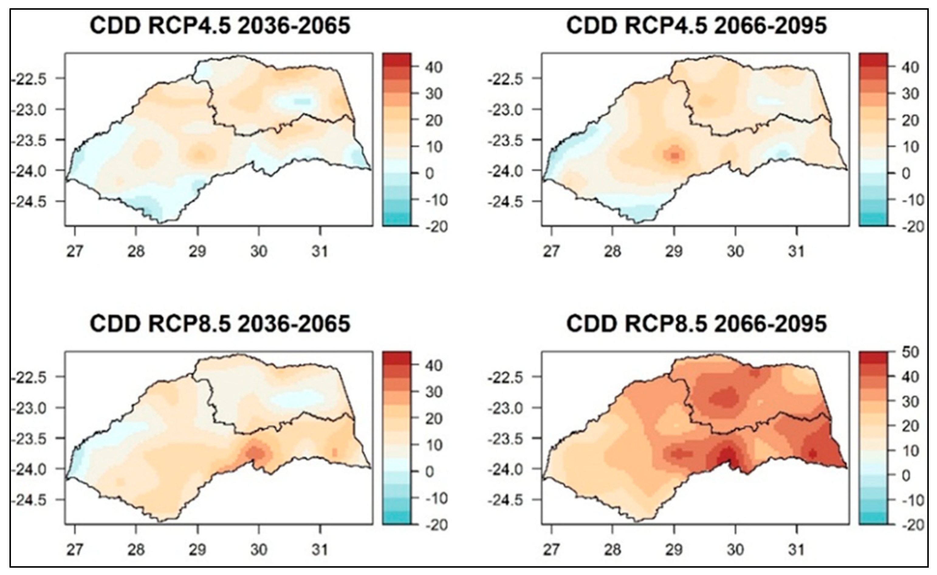
3.1. Projected Temperature and Rainfall in Limpopo, Vhembe District Municipality

Figure 7 demonstrates the projected annual temperature for both RCP 4.5 and RCP 8.5 for VDM. A noticeable increase in temperature is observed for both scenarios, with an increase between 1 and 1.5 °C for the near future (2036–2065) under the RCP 4.5 moderate scenario. Meanwhile, for RCP 8.5, where no significant action is taken to curb greenhouse gas emissions, the eastern parts of VDM are observed to have an increase of 2 °C, while, in the western parts, the temperature increase is 3 °C. In the far future, temperature increases will intensify for both scenarios. This result suggests that the VDM will likely experience episodes of heat waves and heat stress. These conditions are unfavourable for livestock production and the agricultural value chain. Furthermore, the projected increase in temperature is likely to favour more severe and prolonged drought conditions.
Rainfall is a variable parameter illustrated for VDM’s projected annual total rainfall change. Figure 8 shows a decrease in rainfall for both the RCP scenarios. A decrease will be observed in the near future, particularly in the centre parts of the VDM, at 5–10%. These trends are expected to intensify, with the most pronounced between 10 and 20%. The decrease in rainfall will be strengthened in the far future and will cover the whole VDM, especially under the no-mitigation scenario (RCP 8.5).
The projected temperature and rainfall in VDM raise a huge concern because the community relies mostly on rainfed agriculture. With increasing temperatures, the evapotranspiration rate may increase, and this will have a negative impact on water resources and availability. Constraints on water resources may have implications for agriculture and food security. Moreover, these changes may affect the use of renewable energy such as hydropower.
Analysis of Consecutive Dry Days (CDDs) and Simple Daily Intensity Index (SDII) for the Limpopo province and VDM was considered. The calculation of the two extreme indices followed was from http://etccdi.pacificclimate.org/list_27_indices.shtml (accessed 1 November 2024), where CCD is defined as the maximum number of consecutive days with precipitation < 1 mm. Conversely, the SDII is defined as total precipitation divided by the number of wet days.
Indicated in Figure 9 is the CDDs, which, under RCP 4.5, in the near future, is observed to increase by a maximum of 20 to 30 days in the centre of VDM. On the other hand, in the far future, an increase in the same magnitude will be observed in the western part of the district. For the business-as-usual scenarios (no mitigation) in the near future, the CDD increase is observed in the northern and southern parts of VDM. In contrast, in the far future, the increase in CDD will intensify with a magnitude of over 40 days and will cover the whole region of VDM.
The SDII shown in Figure 10 for VDM demonstrates variability across the scenarios and periods. Some areas in the VDM will experience an increased SDII, while others will experience a decrease in the SDII. The signals of the extreme indices considered in this study demonstrate that VDM is susceptible to extreme end tails, indicative of floods and drought conditions. Climate change will impact the country’s economy, water security, food security, energy security, and health.

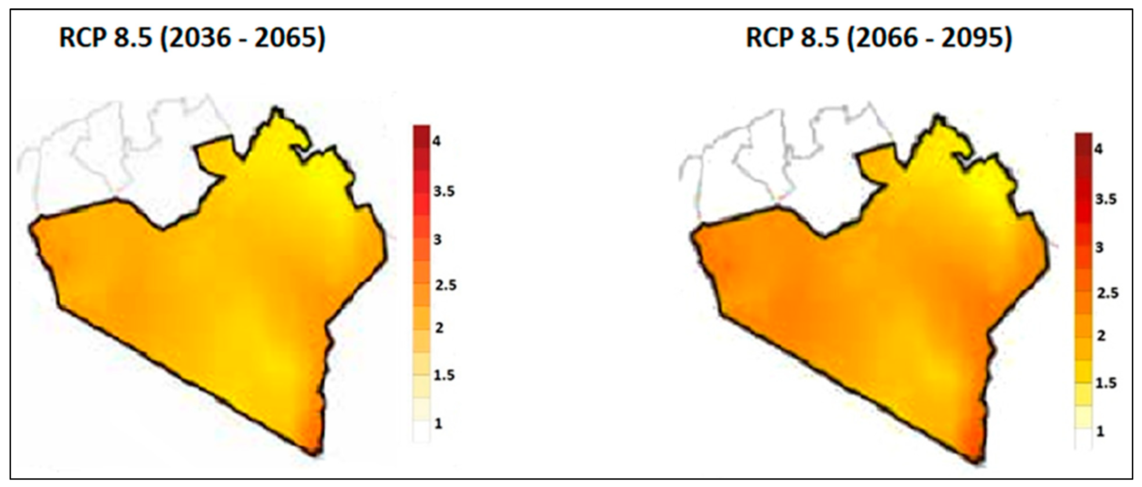
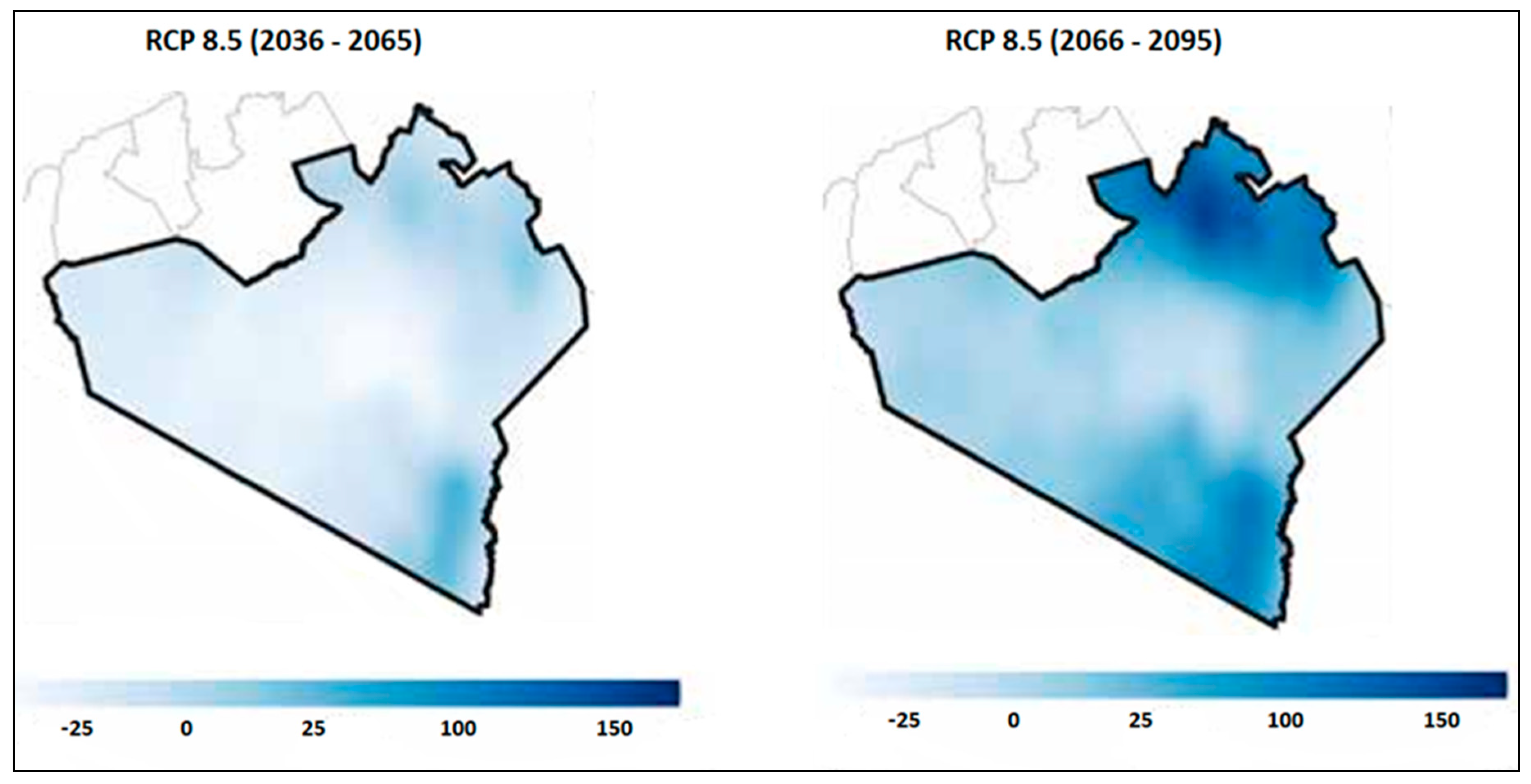
3.2. Projected Temperature and Rainfall in Narok County

Figure 11 shows the annual surface temperature for the worst-case scenario, no mitigation (RCP 8.5), for the near-future 2036–2065 and far-future 2066–2095 periods. Clearly illustrated is that the warming across Narok County will vary in the near future, with northern parts warming at over 1.5 °C and the rest of the country between 1 °C and 1.5 °C. On the other hand, in the far future, the increase in temperature is intensified. Most of Narok County is projected to have increased temperatures of over 2 °C. The findings agree with the Kenya Climate profile conducted in 2020, where temperature trends were projected to continue rising by over 1.5 °C by 2050 and over 3 °C by the end of the century. The projected increase in temperature will have significant implications for health, agriculture, water, and energy sectors. The above-mentioned sectors are climate-sensitive; therefore, these sectors need to develop climate change adaptation strategies and smart technologies that reduce vulnerability.
Figure 12 illustrates the annual total rainfall change in Narok County. Unfortunately, rainfall is a variable parameter. According to Korir [17], climate change has caused Narok County’s rainfall season to become more unpredictable. In Figure 12, we observed that, in the near future, some areas will have increased rainfall (south of Narok), while, in a big part of Narok, no change in rainfall is observed. Meanwhile, in the far future, a clear sign of an increase in rainfall is observed in most parts of Narok County. In this regard, extreme rainfall events are expected to increase in frequency, duration, and intensity, leading to high flooding in Kenya. In April 2024, various media reported that extreme rainfall and floods had impacted larger areas of Kenya. Since this was countrywide, the reports attributed the flooding to the changing climate.

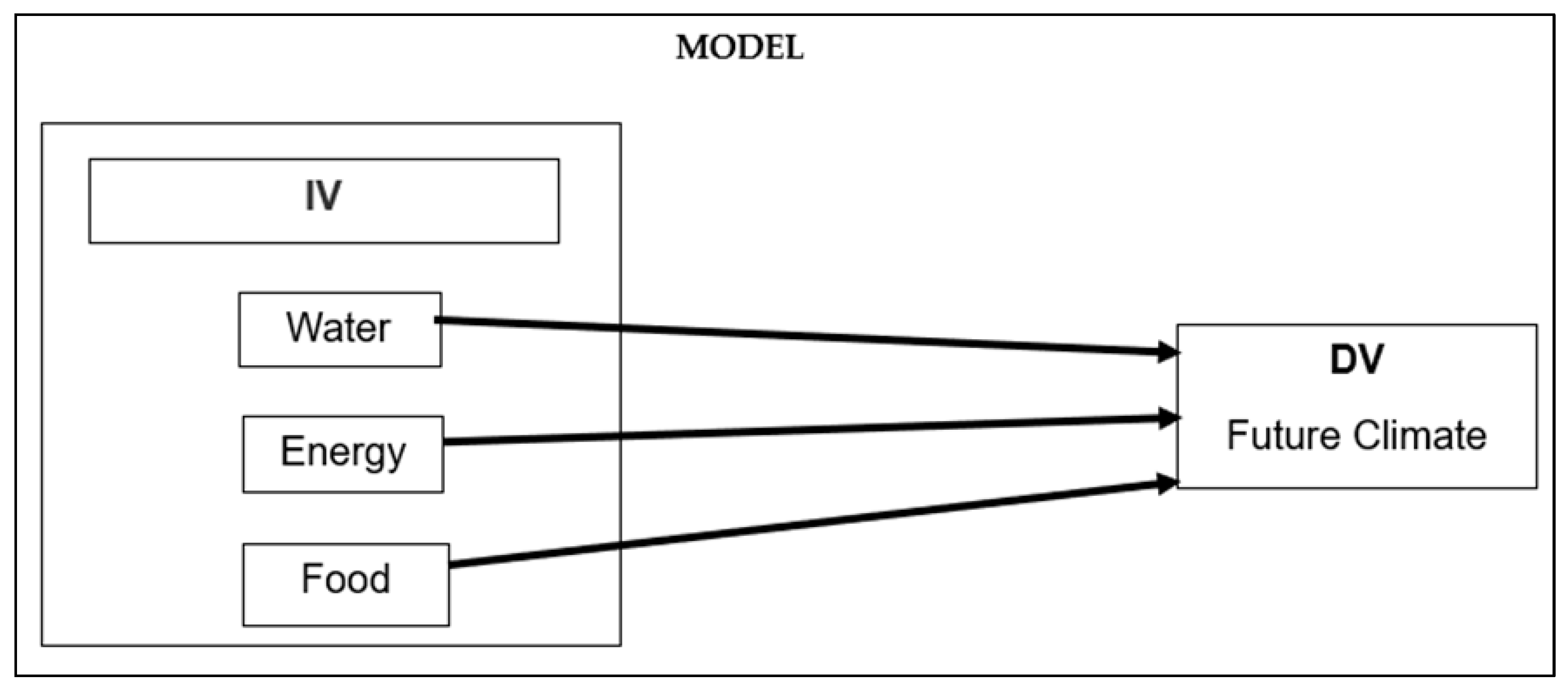
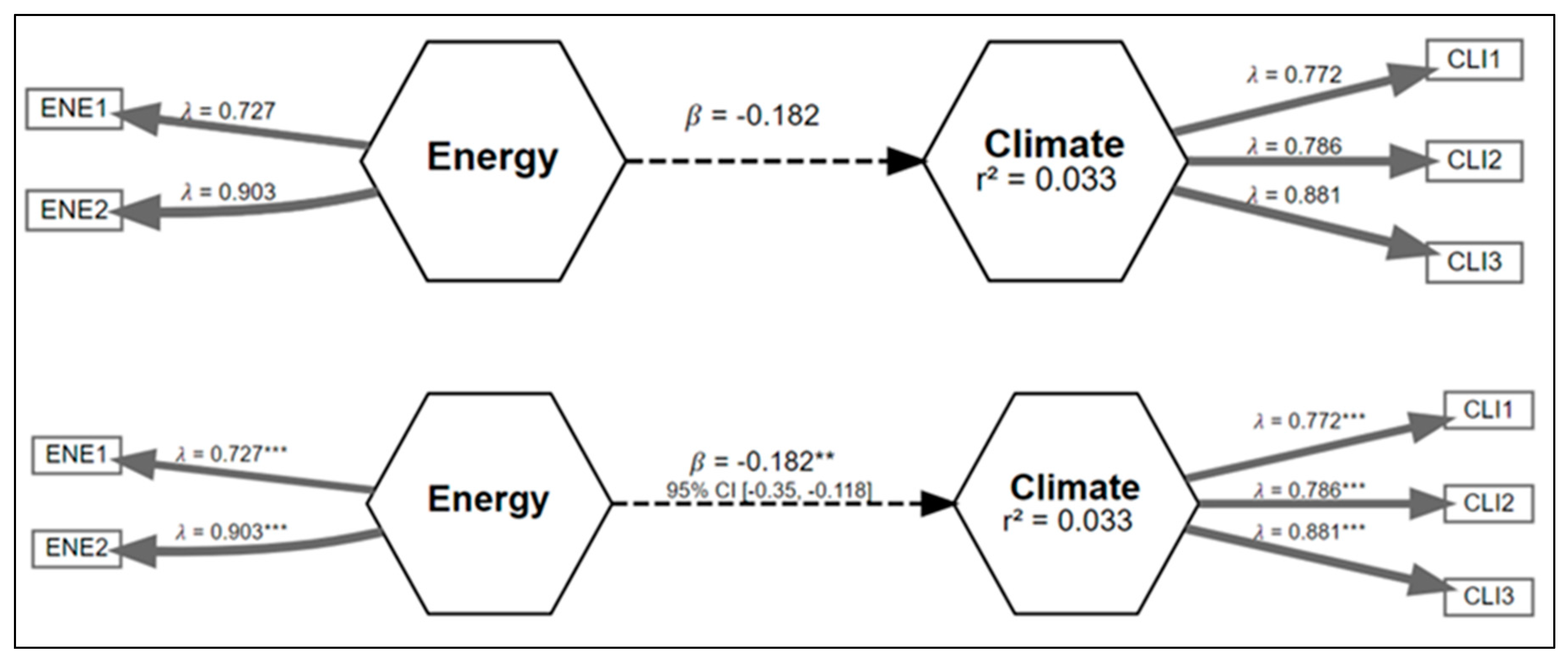
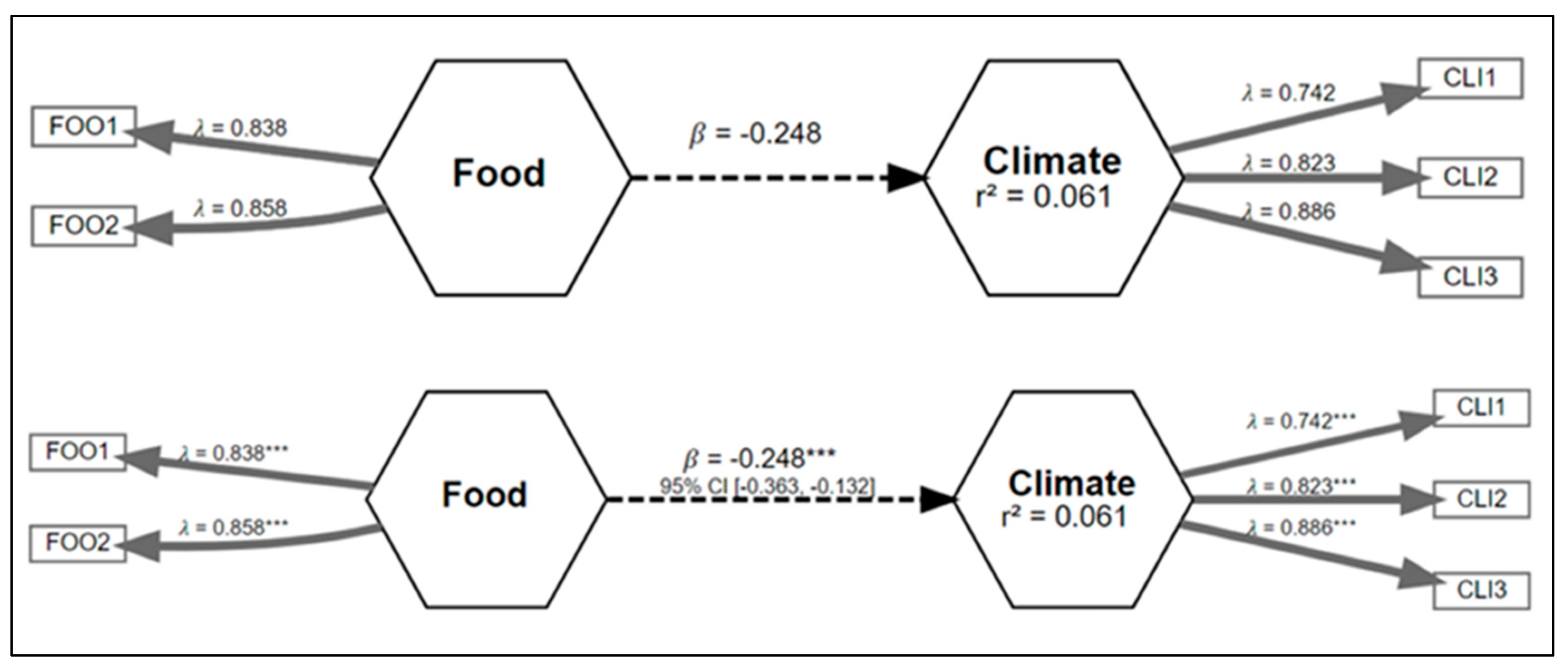
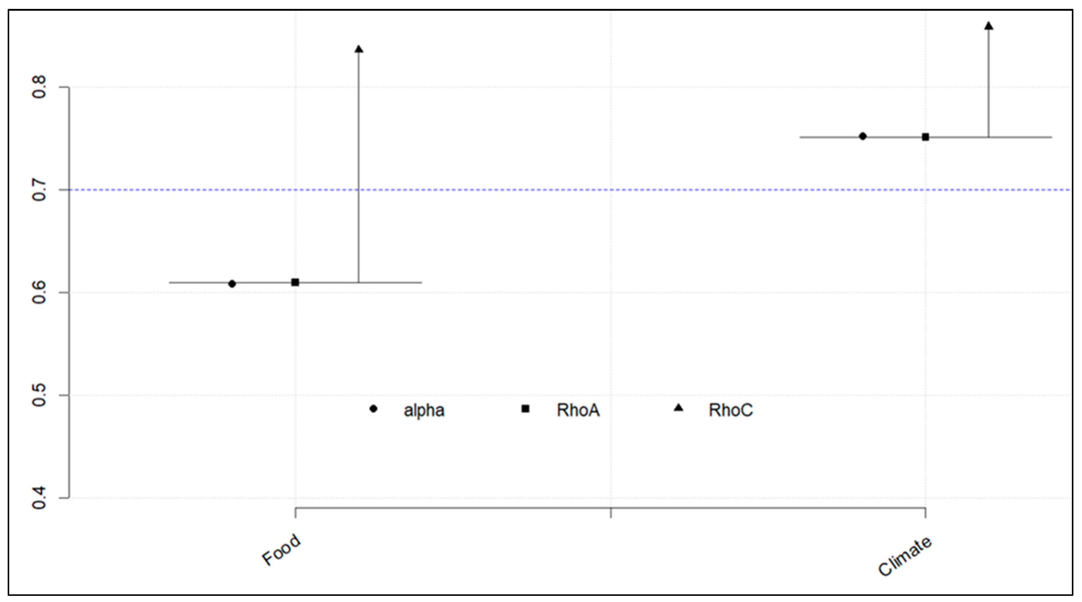
3.3. How Projected Climate Change May Affect the Connections Between Water, Energy, and Food Nexus Resources

The projected climate change in the study sites is associated with extreme events such as droughts, floods, and increased temperatures. According to Mpandeli et al. [39], the global food system is already facing an unparalleled confluence of stresses that could worsen over the next 40 years. By the year 2050, the demand for food and water will increase by 50%, while the global energy demand will have doubled [39]. It is clear from these results that developmental options ought to consider several perspectives of the current debate on just energy transition.
Both VDM and Narok County’s economy and livelihood depend on rain to provide water, energy, and food for the communities. The economy’s dependence on rainfed agriculture in both study sites makes food systems highly sensitive to changing rainfall patterns. The projected climate will exacerbate the challenges of meeting the WEF needs. The anticipated perturbation in agriculture will affect food availability and accessibility. On the other hand, changes in the frequency and intensity of rainfall lead to increased incidences of droughts and floods, which impact food production and distribution. Adverse changes in the quantity, quality, and accessibility of water resources would make it more energy-intensive to pump water from farther or deeper depths or purify water of lower quality, increasing competition for the limited supply of water resources between the food and energy sectors. In this regard, potential modifications in the feedstocks used for renewable energy could have additional effects on the energy system.

3.4. Developing a Modelling Framework Based on Questionnaire Responses

To capture the views and opinions of the communities in Vhembe District Municipality and Narok County, we formulated a direct modelling framework between water, energy, and food resources and climate to understand the present and future impacts of climate change as perceived by the study sites. Figure 13 shows the modelling framework with independent variables (IV—water, energy, and food) and dependent variables (DV—future climate). The extent of the investigation was limited to a basic understanding of how the respondents perceived the impact of climate change on the availability and accessibility of WEF resources.

3.5. The Developed Framework

Relationship 1 is water and climate for the original model (top), and the bootstrapped model (bottom) is shown in Figure 14. The bootstrapped model indicates if the relationship is significant or non-significant, where a 5% confidence interval for the direct path is calculated [20]. Water has two measured variables, while climate has three measured variables. Clearly illustrated in Figure 14 is that water has a significant negative link to climate with a coefficient of β = −0.177 ** (asterisk indicates significant level). A measure of reliability to show the confidence of the model accuracy indicated by Alpha, rhoC, and rhoA to exceed the threshold of 0.7 [20] is shown in Figure 15. Climate indicates more reliability for relationship 1, illustrated in Figure 15.
Figure 16 indicates relationship 2 for energy and climate for the original model (top) and bootstrapped model (bottom). Similarly to relationship 1, relationship 2 indicates that energy has a significant indirect effect on climate with coefficients β = −0.182 **. For relationship 2 (Figure 17), climate shows more reliability than energy, with only rhoC exceeding 0.7. Furthermore, we explored relationship 3 (food and climate) in Figure 18. Like water and energy, food also depicts a significant indirect negative impact on climate with a coefficient of 0.248 **. The reliability graph in Figure 19 shows that climate is more dependable.
The framework results for the three relationships, in line with the communities’ perceptions from both the study sites, illustrate that the WEF resources in the study sites were significantly indirectly impacted by future climate. According to Zwane et al. [20], the negative impacts influencing the three sectors mostly manifest from the increased stress and scarcities of the WEF resources, complemented by a high rate of population growth and variations in resource consumption, including land-use patterns, and exacerbated by climate change.

4. Discussion

This study considered two sites with similar socio-economic, environmental, and climatic conditions. It was, therefore, prudent to characterise the present and projected future climatic conditions. Our analysis results point to pronounced hydroclimatic extremes [8,9]. The expected frequent hydroclimatic extremes will profoundly impact climate-sensitive sectors, such as water, agriculture, energy, the built environment, and health. To respond to these hydroclimatic extremes, innovative and transformative solutions and interventions that include remotely sensed early warning systems, scenario planning, horizon scanning, one health and foresight ought to be operationalised and deployed to enhance resilience and adaptation. Results from this study have practical implications for policymakers from the perspective of prioritising future developmental options that the two study regions would consider improving. The survey results of existing water, energy, and food resources in the study sites demonstrated that the resources are generally constrained with negative availability implications in the near future.
Additionally, the existing interlinkages of the WEF resources are complex and, therefore, not easily understood. Against this backdrop, a parsimonious modelling framework was developed to guide strategic policy management decisions. The modelling framework, which can be replicated in other areas, considers the interlinkages between the WEF resources as constrained by present and projected climate change proxies. The utility of this framework is that it considers the community’s views of present and projected climate change impacts. As a result, the community’s perspective of climate change impacts is incorporated into the modelling framework. It is opined that the developed framework is robust, based on the vital reliability measures often reported in Structural Equation Modelling (SEM). The modelling framework results illustrate that the projected climate change will alter the present WEF nexus interlinkages. This implies that the future interlinkages and trade-offs of the WEF resources would inform developmental policies that will help sustain the community’s resilience and, therefore, sustainable livelihoods.
The novelty of this study is that it seeks to simplify the often-complex WEF nexus modelling framework, which is largely theoretical but has few practical localised implications. It is opined that, for the first time, the current study infuses the community’s perspectives of climate change impacts onto a modest WEF nexus modelling framework based on SEM, thus critical for the following:
  • Identifying critical research needs and evaluating ecosystem service practices with the potential for multiple synergies and trade-offs. The proposed framework allows the timely identification of these conflicts and co-benefits for holistic, transformative, and transdisciplinary interventions.
  • Simplifying the complexity and challenges associated with climate change and its impacts on water, energy, and food. The developed framework acts as a guide for policymakers to provide strategic interventions in various scenarios.
  • The results are key in identifying knowledge gaps and future research needs, including developing a harmonised policy framework to guide the operationalisation of the WEF nexus.
  • The results also indicate that transformative approaches do not work in silos, as each transformative approach is informed by the other. The present study has shown the interlinkages between the WEF nexus and scenario planning and how these can inform one health and horizon scanning.

5. Conclusions

The WEF nexus concept and analytical tools can provide evidence to inform the co-development of integrated climate change adaptation and mitigation strategies that promote sustainability and resilience for people and the planet through the better management of interlinked and interdependent resources. The present study illustrated that VDM and Narok County share similar socio-economic and socio-ecological challenges. Future changes in rainfall and temperature will exacerbate the scarcity of WEF resources and increase the vulnerability in both study sites. An integrated and systemic WEF resource management is required to build the resilience of marginalised communities in VDM and Narok County while also enhancing the attainment of sustainable development goals (SDG 1, 2, 3, 6, 7 and 13). In this study, we successfully quantified and modelled the interlinkages of WEF resources from the supply and demand perspective. This is vital for cascading effective calculation of the direct and indirect WEF nexus loops. Moreover, the present study provides recommendations for policy and decision-makers in scaling up and implementing the WEF nexus approach. This study’s results categorically showed an imbalance in resource management in Narok County and the Vhembe District Municipality. Owing to the projected hydroclimatic extremes in both study sites, we demonstrated that transformative, gender-inclusive socio-economic developmental options should be adopted to ensure that communities in the study sites are sustainable and resilient. The results on how climate change would affect the interlinkages of WEF resources from the models and output from fieldwork highlighted the importance of transdisciplinary approaches that co-produce and co-implement solutions with communities. Moreover, the present study has established that WEF security is closely related to the sustainability of humans, the environment and the economy, highlighting the broader dimensions of the WEF nexus approach. Inadequate supply or access to WEF resources can cause several health issues, such as poor water quality, an unhealthy diet, and a lack of intermittent energy. These effects become more pronounced when these variables are combined. Thus, we advocate for transdisciplinary approaches that bridge the gaps between science, policy, implementation, and society. Without targeted interventions and inclusive climate policies, the gap between vulnerable populations and populations with greater resilience will continue to widen. Addressing these challenges requires a commitment to equitable climate action, integrating the voices of marginalised communities into adaptation and mitigation strategies to ensure a just and sustainable future for all.

Author Contributions

Conceptualisation, N.Z., J.O.B. and T.M.; methodology, N.Z. and J.O.B.; software, N.Z.; validation, N.Z., J.O.B. and C.M.B.; formal analysis, N.Z. and J.O.B.; investigation, N.Z. and M.I.; data curation, N.Z., S.H.N., A.J. and L.D.; writing—original draft preparation, N.Z., J.O.B., L.N., B.P. and S.M.; writing—review and editing, all authors; visualisation, N.Z. and J.O.B.; supervision, J.O.B. and T.M.; project administration, J.O.B.; funding acquisition, J.O.B. and T.M. All authors have read and agreed to the published version of the manuscript.

Funding

This research was funded by the Water Research Commission of South Africa, grant numbers C2019/2020-00017 and C2019/2020-00020. The Sustainable and Health Food Systems—Southern Africa (SHEFS-SA) Programme, supported by the Wellcome Trust [Grant No 227749/Z/23/Z]; TM is supported by the Wellcome Trust.

Data Availability Statement

Data is contained within the article.

Acknowledgments

The authors acknowledge the financial support from the Water Research Commission of South Africa under project number C2019/2020-00020 and the South African Weather Service for providing a conducive work environment. Furthermore, the authors wish to thank the anonymous reviewers for providing very helpful and valuable comments and recommendations that contributed towards the improvement of the quality of this article.

Conflicts of Interest

The authors declare no conflicts of interest.

References

  1. Muhirwa, F.; She, L.; Elshkaki, A.; Chiaka, J.C.; Zhong, S.; Bönecke, E.; Hirwa, H.; Seka, A.M.; Habiyakare, T.; Tuyishimire, A.; et al. Alert in the dynamics of water-energy-food production in African countries from a nexus perspective. Resour. Conserv. Recycl. 2023, 194, 106990. [Google Scholar] [CrossRef]
  2. Oliver, O.; Nnamdi, A.; Nwulu, I. The water-energy-food-ecosystem nexus scenario in Africa: Perspective and policy implementations. Energy Rep. 2024, 11, 5947–5962. [Google Scholar]
  3. Molefe, T.; Inglesi-Lotz, R. Examining the water–energy–food (WEF) nexus through an SDG lens for the big 5 African countries. Environ. Dev. Sustain. 2023, 25, 14083–14100. [Google Scholar] [CrossRef]
  4. Wakeford, J.J. The water–energy–food nexus in a climate-vulnerable, frontier economy: The case of Kenya. Rep. Prep. United Kingd. Dep. Int. Dev. Sustain. Inst. S. Afr. 2017, 3, 1–29. [Google Scholar]
  5. Kanda, E.K.; Lusweti, E.; Odhiambo, K.O. Water–energy–food nexus in Kenya: A review of policy interventions. World Water Policy 2023, 9, 823–836. [Google Scholar] [CrossRef]
  6. Mabhaudhi, T.; Simpson, G.; Badenhorst, J.; Mohammed, M.; Motongera, T.; Senzanje, A.; Jewitt, A.; Naidoo, D.; Mpandeli, S. Assessing the state of the water-energy-food (WEF) nexus in South Africa. Water Res. Comm. (WRC) Pretoria S. Afr. 2018, 76, 126. [Google Scholar]
  7. David, L.O.; Aigbavboa, C.; Nwulu, N.; Adepoju, O.O. Water, Energy, and Food (WEF) Resources in South Africa. In Sustainable Synergy: A Digital Framework for the Water-Energy-Food Nexus Project Delivery in Developing Economies; Springer: Cham, Switzerland, 2024; pp. 197–217. [Google Scholar]
  8. Botai, C.M.; Botai, J.O.; Tazvinga, H.; Murambadoro, M.; Nhamo, L.; Ncongwane, K.P.; Mengistu, M.G.; Zwane, N.; Wamiti, E.; Mpandeli, S.; et al. Assessment of rural livelihoods, health and wellbeing in Vhembe District Municipality, South Africa and Narok County, Kenya: A water-energy-food nexus perspective. Environ. Sci. Policy 2024, 159, 103817. [Google Scholar] [CrossRef]
  9. Zwane, N.; Botai, J.O.; Botai, C.M.; Mabhaudhi, T. Sustainability of the Linkages Between Water–Energy–Food Resources Based on Structural Equation Modeling Under Changing Climate: A Case Study of Narok County (Kenya) and Vhembe District Municipality (South Africa). Sustainability 2024, 16, 9689. [Google Scholar] [CrossRef]
  10. Intergovernmental Panel on Climate Change (IPCC). Climate change 2021: The physical science basis. In Contribution of Working Group I to the Sixth Assessment Report of the Intergovernmental Panel on Climate Change; Masson-Delmotte, V., Zhai, P., Pirani, A., Connors, S.L., Péan, C., Berger, S., Caud, N., Chen, Y., Goldfarb, L., Gomis, M.I., et al., Eds.; Cambridge University Press: Cambridge, UK, 2021; Available online: https://www.ipcc.ch/report/ar6/wg1/ (accessed on 1 November 2024).
  11. Field, C.B.; Barros, V.R. (Eds.) Climate Change 2014-Impacts, Adaptation and Vulnerability: Regional Aspects; Cambridge University Press: Cambridge, UK, 2014. [Google Scholar]
  12. Engelbrecht, F.; Adegoke, J.; Bopape, M.J.; Naidoo, M.; Garland, R.; Thatcher, M.; McGregor, J.; Katzfey, J.; Werner, M.; Ichoku, C.; et al. Projections of rapidly rising surface temperatures over Africa under low mitigation. Environ. Res. Lett. 2015, 10, 085004. [Google Scholar] [CrossRef]
  13. Mbokodo, I.; Bopape, M.J.; Chikoore, H.; Engelbrecht, F.; Nethengwe, N. Heatwaves in the future warmer climate of South Africa. Atmosphere 2020, 11, 712. [Google Scholar] [CrossRef]
  14. McBride, C.M.; Kruger, A.C.; Dyson, L. Trends in Probabilities of Temperature Records in the Non-Stationary Climate of South Africa. Int. J. Clim. 2021, 42, 1692–1705. [Google Scholar] [CrossRef]
  15. Ihinegbu, C. Conceptualization and management of disasters and climate change events in Africa: A review. SN Appl. Sci. 2021, 3, 848. [Google Scholar] [CrossRef]
  16. Mulwa, F.; Li, Z.; Fangninou, F.F. Water scarcity in Kenya: Current status, challenges and future solutions. Open Access Libr. J. 2021, 8, 1–5. [Google Scholar] [CrossRef]
  17. Korir, J.; Ngenoh, E. Factors Influencing the Adaptation Decisions to Impacts of Climate Change among the Maasai Pastoral Community in Narok County, Kenya. Agric. Sci. 2019, 10, 689–705. [Google Scholar] [CrossRef]
  18. Botai, C.M.; Botai, J.O.; de Wit, J.C.; Ncongwane, K.P.; Adeola, A.M. Drought characteristics over the Western Cape Province, South Africa. Water 2017, 9, 876. [Google Scholar] [CrossRef]
  19. Botai, C.M.; Botai, J.O.; Dlamini, L.; Zwane, N.; Phaduli, E. Characteristics of Droughts in South Africa: A Case Study of Free State and North West Provinces. Water 2016, 8, 439. [Google Scholar] [CrossRef]
  20. Botai, C.M.; Botai, J.O.; de Wit, J.P.; Ncongwane, K.P.; Murambadoro, M.; Barasa, P.M.; Adeola, A.M. Hydrological Drought Assessment Based on the Standardized Streamflow Index: A Case Study of the Three Cape Provinces of South Africa. Water 2021, 13, 3498. [Google Scholar] [CrossRef]
  21. Omambia, A.N.; Shemsanga, C.; Li, Y. Combating climate change in Kenya: Efforts, challenges and opportunities. Rep. Opin. 2009, 1, 12–23. [Google Scholar]
  22. Almulhim, A.I.; Alverio, G.N.; Sharifi, A.; Shaw, R.; Huq, S.; Mahmud, M.J.; Ahmad, S.; Abubakar, I.R. Climate-induced migration in the Global South: An in-depth analysis. Npj Clim. Action 2024, 3, 47. [Google Scholar] [CrossRef]
  23. Bazilian, M.; Rogner, H.; Howells, M.; Hermann, S.; Arent, D.; Gielen, D.; Steduto, P.; Mueller, A.; Komor, P.; Tol, R.J.; et al. Considering the energy, water and food nexus: Towards an integrated modelling approach. Energy Policy 2011, 39, 7896–7906. [Google Scholar] [CrossRef]
  24. van Vuuren, D.P.; Nakicenovic, N.; Riahi, K.; Brew-Hammond, A.; Kammen, D.; Modi, V.; Nilsson, M.; Smith, K.R. An energy vision: The transformation towards sustainability—Interconnected challenges and solutions. Curr. Opin Env. Sustain. 2012, 4, 18–34. [Google Scholar] [CrossRef]
  25. Adom, R.K.; Simatele, M.D.; Reid, M. Addressing the challenges of water-energy-food nexus programme in the context of sustainable development and climate change in South Africa. J. Water Clim. Chang. 2022, 13, 2721. [Google Scholar] [CrossRef]
  26. SAWS. Launch of the Climate Change Reference Atlas. 2017. Available online: https://www.weathersa.co.za/home/climatechangeatlas (accessed on 24 October 2024).
  27. Kenya County Climate Risk Profile 2021. Available online: https://climateknowledgeportal.worldbank.org/sites/default/files/2021-05/15724-WB_Kenya%20Country%20Profile-WEB.pdf (accessed on 24 October 2024).
  28. Georgakakos, K.P.; Seo, D.J.; Gupta, H.; Schaake, J.; Butts, M.B. Towards the characterization of streamflow simulation uncertainty through multi-model ensembles. J. Hydrol. 2004, 298, 222–241. [Google Scholar] [CrossRef]
  29. Arora, V.K.; Scinocca, J.F.; Boer, G.J.; Christian, J.R.; Denman, K.L.; Flato, G.M.; Kharin, V.V.; Lee, W.G.; Merryfield, W.J. Carbon emission limits required to satisfy future representative concentration pathways of greenhouse gases. Geophys. Res. Lett. 2011, 38, 1–6. [Google Scholar] [CrossRef]
  30. Voldoire, A.; Sanchez-Gomez, E.; Salas y Mélia, D.; Decharme, B.; Cassou, C.; Sénési, S.; Valcke, S.; Beau, I.; Alias, A.; Chevallier, M.; et al. The CNRM-CM5. 1 global climate model: Description and basic evaluation. Clim. Dyn. 2013, 40, 2091–2121. [Google Scholar] [CrossRef]
  31. Aloysius, N.R.; Sheffield, J.; Saiers, J.E.; Li, H.; Wood, E.F. Evaluation of historical and future simulations of precipitation and temperature in central Africa from CMIP 5 climate models. J. Geophys. Res. Atmos. 2015, 121, 130–152. [Google Scholar] [CrossRef]
  32. Hourdin, F.; Foujols, M.A.; Codron, F.; Guemas, V.; Dufresne, J.L.; Bony, S.; Denvil, S.; Guez, L.; Lott, F.; Ghattas, J.; et al. Impact of the LMDZ atmospheric grid configuration on the climate and sensitivity of the IPSL-CM5A coupled model. Clim. Dyn. 2013, 40, 2167–2192. [Google Scholar] [CrossRef]
  33. Watanabe, S.; Hajima, T.; Sudo, K.; Nagashima, T.; Takemura, T.; Okajima, H.; Nozawa, T.; Kawase, H.; Abe, M.; Yokohata, T.J.G.M.D.; et al. MIROC-ESM 2010: Model description and basic results of CMIP5-20c3m experiments. Geosci. Model Dev. 2011, 4, 845–872. [Google Scholar] [CrossRef]
  34. Dunne, J.P.; John, J.G.; Adcroft, A.J.; Griffies, S.M.; Hallberg, R.W.; Shevliakova, E.; Stouffer, R.J.; Cooke, W.; Dunne, K.A.; Harrison, M.J.; et al. GFDL’s ESM2 global coupled climate-carbon earth system models. Part I: Physical formulation and baseline simulation char-acteristics. J. Clim. 2012, 25, 6646–6665. [Google Scholar] [CrossRef]
  35. Tjiputra, J.F.; Roelandt, C.; Bentsen, M.; Lawrence, D.M.; Lorentzen, T.; Schwinger, J.; Seland, Ø.; Heinze, C. Evaluation of the carbon cycle components in the Norwegian Earth System Model (NorESM). Geosci. Model Dev. 2013, 6, 301–325. [Google Scholar] [CrossRef]
  36. Nesamvuni, A.E.; Tshikolomo, K.A.; Mpandeli, N.S.; De Bruyn, M.; Hlophe-Ginindza, S.; Van Niekerk, J. Perceptions on irrigation water supply and utilisation by smallholder agricultural enterprises in Vhembe district of Limpopo Province, South Africa. Tech. Soc. Sci. J. 2022, 27, 968–979. [Google Scholar] [CrossRef]
  37. Oni, S.A.; Maliwichi, L.L.; Obadire, O.S. Socio-Economic Factors Affecting Smallholder Farming and Household Food Security: A Case of Thulamela Local Municipality in Vhembe District of Limpopo Province, South Africa. Afr. J. Agric. Res. 2010, 5, 2289–2296. [Google Scholar]
  38. Zwane, N. Investigating the Influence of Present and Projected Climate on the Livelihood of Small-Scale Farmers in the Uthungulu District Municipality, KwaZulu Natal, South Africa. Ph.D. Thesis, University of Pretoria, Pretoria, South Africa, 2019. Available online: http://hdl.handle.net/2263/70346 (accessed on 1 November 2024).
  39. Mpandeli, S.; Naidoo, D.; Mabhaudhi, T.; Nhemachema, C.; Nhamo, L.; Liphandzi, S.; Hlahla, S.; Modi, A.T. Climate change adaptation through the water-energy-food nexus in Southern Africa. Int. J. Environ. Res. Public Health 2018, 15, 2306. [Google Scholar] [CrossRef] [PubMed]
Figure 1. SAWS station vs. TAHMO station correlation for temperature maximum in South Africa (- denotes negative correlations).
Water 17 01449 g001
Figure 2. SAWS station vs. TAHMO station showing significant correlation for temperature maximum (asterisk indicates significant correlation and the red line indicate a linear fit of the observations).
Water 17 01449 g002
Figure 3. SAWS station vs. TAHMO station correlation for rainfall in South Africa.
Water 17 01449 g003
Figure 4. SAWS station vs. TAHMO station showing significant correlation for rainfall (asterisk indicates significant correlation and the red line indicate a linear fit of the observations).
Water 17 01449 g004
Figure 5. Limpopo stations bias corrected (grey represents the actual regression points and bold line represent the average regression).
Water 17 01449 g005
Figure 6. Kenya stations bias corrected (grey represents the actual regression points and bold line represent the average regression).
Water 17 01449 g006
Figure 7. Projected annual surface temperature in Vhembe District Municipality.
Water 17 01449 g007
Figure 8. Projected annual total rainfall change in Vhembe District Municipality.
Water 17 01449 g008
Figure 9. Projected consecutive dry days in Vhembe District Municipality.
Water 17 01449 g009
Figure 10. Projected Simple Daily Intensity Index for Limpopo in Vhembe District Municipality.
Water 17 01449 g010
Figure 11. Annual surface temperature projections in Narok County, Kenya.
Water 17 01449 g011
Figure 12. Annual total rainfall change projections in Narok County, Kenya.
Water 17 01449 g012
Figure 13. Community perception modelling framework.
Water 17 01449 g013
Figure 14. Relationship 1 for both sites—Water and Climate model (top) and the bootstrapped model (bottom). The asterisk is the significance level. * p < 0.05, ** p < 0.01, *** p < 0.001.
Water 17 01449 g014
Figure 15. Reliability graph for relationship 1—both sites (the dotted line represent the recommended threshold).
Water 17 01449 g015
Figure 16. Relationship 2 for both sites—Energy and Climate model (top) and the bootstrapped model (bottom). The asterisk is the significance level. * p < 0.05, ** p < 0.01, *** p < 0.001.
Water 17 01449 g016
Figure 17. Reliability graph for relationship 2—both sites (the dotted line represent the recommended threshold).
Water 17 01449 g017
Figure 18. Relationship 3 for both sites—Food and Climate model (top) and the bootstrapped model (bottom). The asterisk is the significance level. * p < 0.05, ** p < 0.01, *** p < 0.001.
Water 17 01449 g018
Figure 19. Reliability graph for relationship 3—both sites (the dotted line represent the recommended threshold).
Water 17 01449 g019
Table 2. List of climate stations across Limpopo.
StationLatitudeLongitudeAltitude
Thohoyandou−22.9730.50600
Polokwane−23.8729.451300
Levubu−23.0930.29650
Oudestad−25.1829.34944
Giyani−23.3230.68455
Mara−23.1429.56894
Phalaborwa−23.9331.15432
Table 3. List of TAHMO stations across Kenya.
Station NameStation CodeLatitudeLongitudeAltitude
Lela Primary SchoolTA00001−0.1834.891156
Koyoo Secondary SchoolTA00018−0.5834.61847
Osodo Secondary SchoolTA00019−0.7534.35546
Woodlands 2000 TrustTA00020−1.6536.86750
Kipsombe Secondary SchoolTA000210.7635.172725
Bubayi-Saboti FarmTA000220.9134.921794
Dwa EstateTA00023−2.3938.01884
Mang’u High SchoolTA00024−1.0737.041600
Kenya Meteorological DepartmentTA00025−1.1349636.768871795
Disclaimer/Publisher’s Note: The statements, opinions and data contained in all publications are solely those of the individual author(s) and contributor(s) and not of MDPI and/or the editor(s). MDPI and/or the editor(s) disclaim responsibility for any injury to people or property resulting from any ideas, methods, instructions or products referred to in the content.

