1. Introduction
Agriculture is the branch of the economy that is responsible for most (over 60%) of the nutrients that flow into the Baltic Sea from Poland [
1]. However, agricultural areas can also be the source of other pollutants that are traditionally associated with heavy industry and highly transformed areas (e.g., development of mineral resources, metal processing and metallurgy, chemical production, etc.). It is generally agreed that broadly defined agronomic activities contribute to the emission of heavy metals, while some of them, such as Cd, are even considered as indicators of agricultural activities such as fertilization [
2], while others, like Hg or Pb, are present in the agricultural lands and cause background losses to the environment [
3,
4]. Moreover, the accumulation of heavy metals in soil causes serious pollution that affects the safety of food production [
5]. Since the actual forms of land use affect the level of pollution of soil and can vary significantly within individual agricultural catchments, studies on a local scale can elucidate the sources of heavy metals related to this type of anthropogenic pressure.
In this study, a suspended sediment flux, commonly recognized as a particle-bound contaminant carrier in surface waters [
6], has been used to investigate the sources of heavy metals within an agricultural catchment. Suspended sediment contamination has been tracked using the fingerprinting method [
7,
8,
9]. This method relies on the assumption that sediments in rivers represent an integral sign of particles, and thus provide information on particle-related contaminants within a corresponding part of the basin. The discrimination between source contributions is typically based on land-use/land-cover typology and their fingerprint properties selected during a statistical analysis.
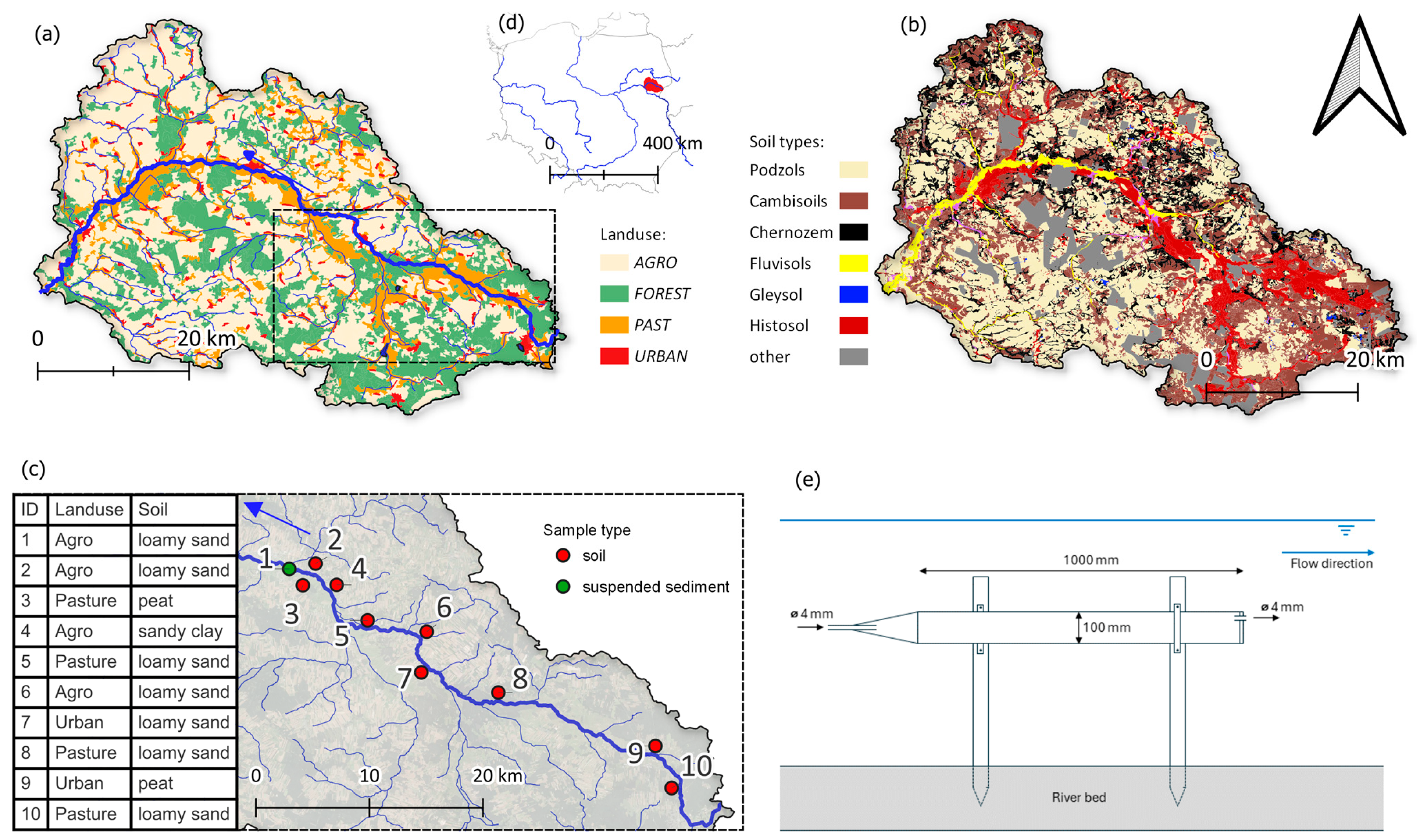
The research was carried out in the agricultural catchment of the Nurzec River (Eastern Poland), where the occurrence of pollutants mainly associated with industrialized/urbanized areas was hard to expect in the past. The main aim of the study was to determine the sources of heavy metals transported by suspended sediment and to assess their content in soil. To fully address this aim, the author of this study utilised a “hybrid approach” [
10], combining information from classic field monitoring with a statistical model. This approach allowed them to estimate the importance of sources of heavy metals by predicting the impact of land use of the analysed catchment on the quality of suspended sediment. The analysis was carried out for the three most common forms of land use present in the analysed area (arable lands, pastures, and urban areas).
Field soil monitoring within the State Environmental Monitoring (SEM) in Poland is entirely focused on arable lands and relatively scant in terms of localisation and frequency. Therefore a study that is based on the assessment of soil quality (containing a wide range of elements, including heavy metals) will be extremely useful for the purposes of further soil studies in this area and in similar catchments. It would also serve as a recommendation for other catchments with insufficient soil information and provide conclusions on similar subjects. This approach also enabled the assessment of the current state of heavy metal contamination in the analysed catchment area. The statistical model in turn facilitated the identification of their transport routes through suspended sediment from known land-use categories. Results obtained using this hybrid approach are of direct significance to local stakeholders in terms of the adaptation of activities aimed at the assessment of sources of heavy metal pollutants in the catchment area and the limitation of their transport.
3. Results
3.1. Soil
The analysis of the correlation between individual elements (Spearman rank correlation coefficient) revealed a statistically significant (p = 0.05) correlation (>0.8) between 14 pairs of elements. Following an analysis of the concentrations of the tested elements in terms of outliers, 1 measurement was rejected. The main components of soil in the analysed samples included Fe (mean value: 34,067 mg·kg−1), Al (24,577 mg·kg−1), and Ca (18,999 mg·kg−1). Out of all 1116 chemical determinations, 1025 (91.8%) were above the limit of quantification value (LOQ). Among the values below LOQ, 21 concerned B, 15: Bi, 14: Ag, 12: Se, 9: Hg, 8: W, 6: Cd, 4: Ni, and 1: Sr. The testing of values for the normal distribution of data (Shapiro–Wilk and Kolmogorov–Smirnov tests) revealed that 17 of the elements failed to demonstrate normal distribution at a statistically significant level (p = 0.05). Following the application of a logarithm (base 10) function, the hypothesis on the normal distribution of 14 variables was rejected.
Seasonal variability of the data series was tested to verify the consistency of data and to ensure that the obtained data series mainly depended on land-use characteristics. The verification was based on a non-parametric Kruskal–Wallis H test (p > 0.05). The data turned out to be seasonally unaffected, which enables the performance of further fingerprinting analysis on the compiled data.
3.2. Soil Pollution Assessment
The implemented methods enabled the calculation of I
geo and EF for 440 samples (11 elements, 4 surveys, 10 sampling points). The values for suspended sediment were calculated for provisional assessment, as the applied geochemical background refers to the soil samples. The results for both indices were consistent and their Spearman rank correlation was 0.81. Among the calculated results, 78.8% of samples had the lowest I
geo (0) and EF (1) class, which corresponded with uncontaminated or minimally enriched samples. In total, 10.4% of samples had an I
geo class in the range of 2–6, while 8.1% of samples had an EF class in the range of 2–5. Only two samples of Hg taken from sampling points 2 and 3 were assigned to the maximum classes of I
geo and EF of 6 and 5, respectively.
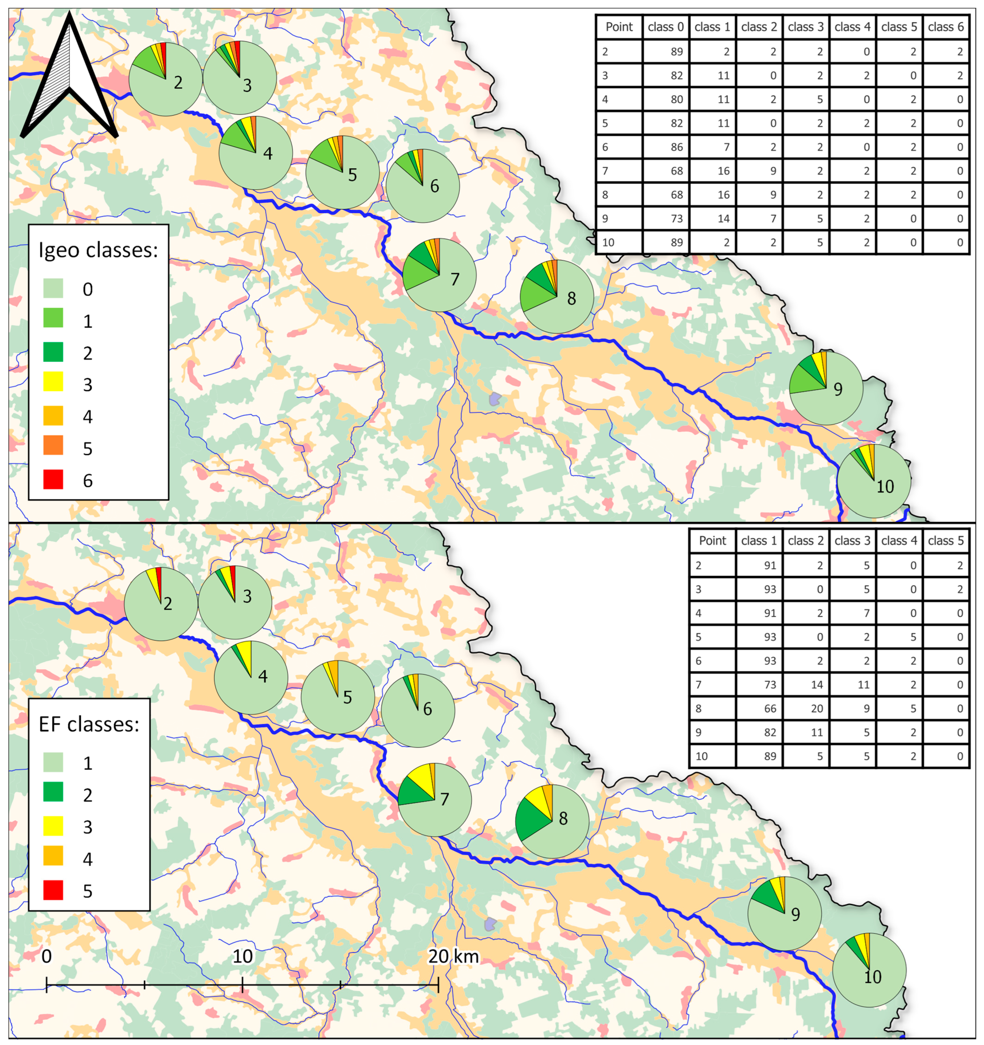
Figure 2 shows the results of classification of both indices for the samples of soils within the Nurzec River catchment.
The overall results of I
geo and EF demonstrate that most of the soil samples from the Nurzec River catchment were uncontaminated by the studied elements. Heavy contamination by heavy metals was observed locally and involved only Hg (14 samples classified as heavily contaminated). Moderate contamination (2nd or 3rd class of I
geo or EF) was observed broadly among Zn samples (12 soil samples) and As (9 soil samples). The maximum values of I
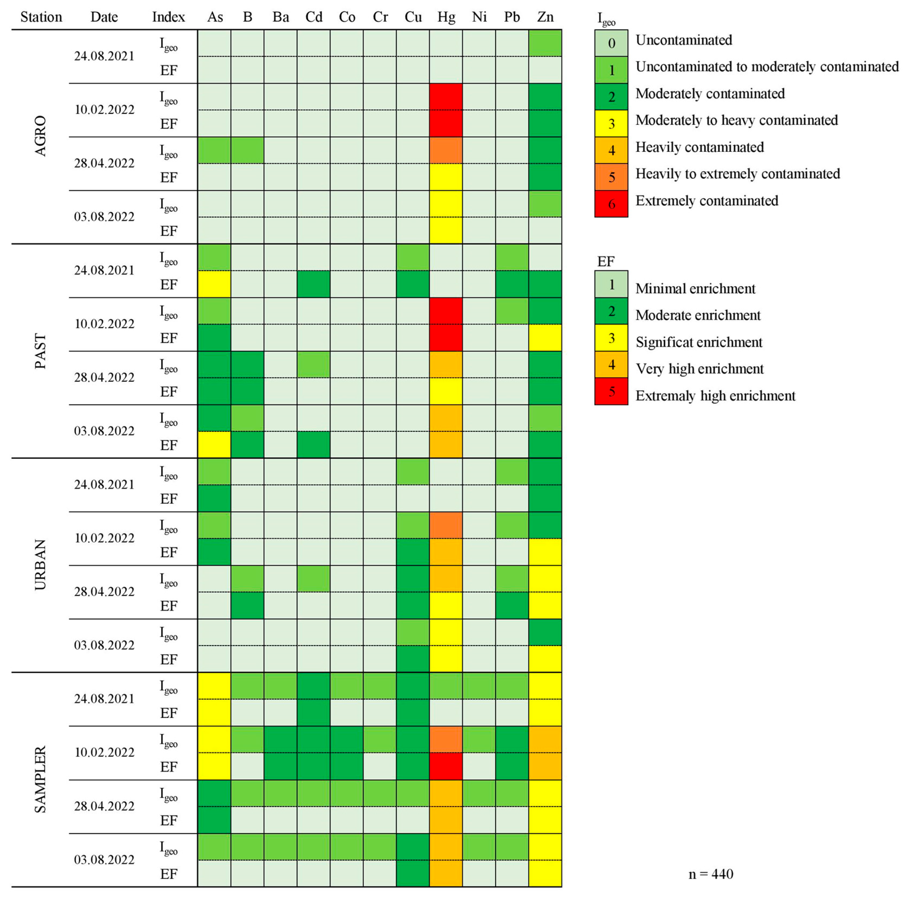
geo and EF categorized according to elements and land-use types are shown in
Figure 3.
Samples with values higher than the Igeo = 0 or EF = 1 classes were more common among samples from PAST (23 samples) and URBAN (20 samples) land-use categories. Nevertheless, the maximum Igeo or EF values (6 and 5, respectively) were observed in the AGRO and PAST areas (Hg). Moreover, AGRO samples were not contaminated by As and B, while in the case of PAST and URBAN samples, the highest Igeo or EF class was the second (B) and third (As) class for these elements. The highest contamination (Igeo and EF above 5) was observed only in Hg samples. This situation was present in most of the sampling points. The absolute values of mercury in these samples ranged between 2.4 and 8.9 mg·kg−1. High concentrations of Zn (up to 367.4 mg·kg−1) were found across all land-use categories, with the highest values found in URBAN areas. This was reflected in the classification of both Igeo and EF indices (class 2 or 3).
Suspended sediment samples demonstrated higher values of Igeo and EF in comparison with the results of soil analysis. Classes of Igeo in the range of 4–6 and EF of 4–5 were observed among Hg samples. This indicates heavy/extremely high contamination and the content of Hg in suspended sediment from the Nurzec River. High values of Igeo and EF were observed among Zn (3–4) and As (Igeo and EF class 3) samples. Moderate contamination (Igeo and EF class 2) was also attributable to Cd and Cu samples, as well as Ba, Co, and Pb samples. The values of indices were higher in suspended sediment than in soils. Other samples demonstrated Igeo and EF classes lower than 2, which corresponds with minimal contamination/enrichment.
3.3. Fingerprinting
The first step of the fingerprinting procedure (Kruskal–Wallis H test) resulted in the elimination of 13 out of 31 of the chosen parameters. The elements that passed the test were: Al, As, Ca, Cr, Cu, Fe, K, Li, Mg, Mn, Ni, P, Pb, S, Sb, Sr, V, and Zn. The results of the test are shown in
Table 1. The selected elements were subsequently examined during the second testing stage (Wilcoxon test) to additionally eliminate all non-significant parameters. The final set of parameters selected for the fingerprinting procedure included 14 elements: Al, Ca, Cr, Cu, K, Li, Mg, Mn, Ni, Pb, S, Sb, Sr, and V. The results of the Wilcoxon test are shown in
Table 2. Fisher’s linear discrimination analysis was then performed in order to develop a set of discriminating functions that can help to predict sampler values on the basis of the values of other quantitative variables. The analysis resulted in the achievement of a set of discriminant function coefficients for each of the analysed variables.
Table 3 presents the discriminant function coefficients.
On the basis of the obtained coefficients, the first standardised discriminating function is:
The implementation of the above equation as a model of predicting the contamination of suspended sediments by heavy metals resulted in the achievement of the following measures: r
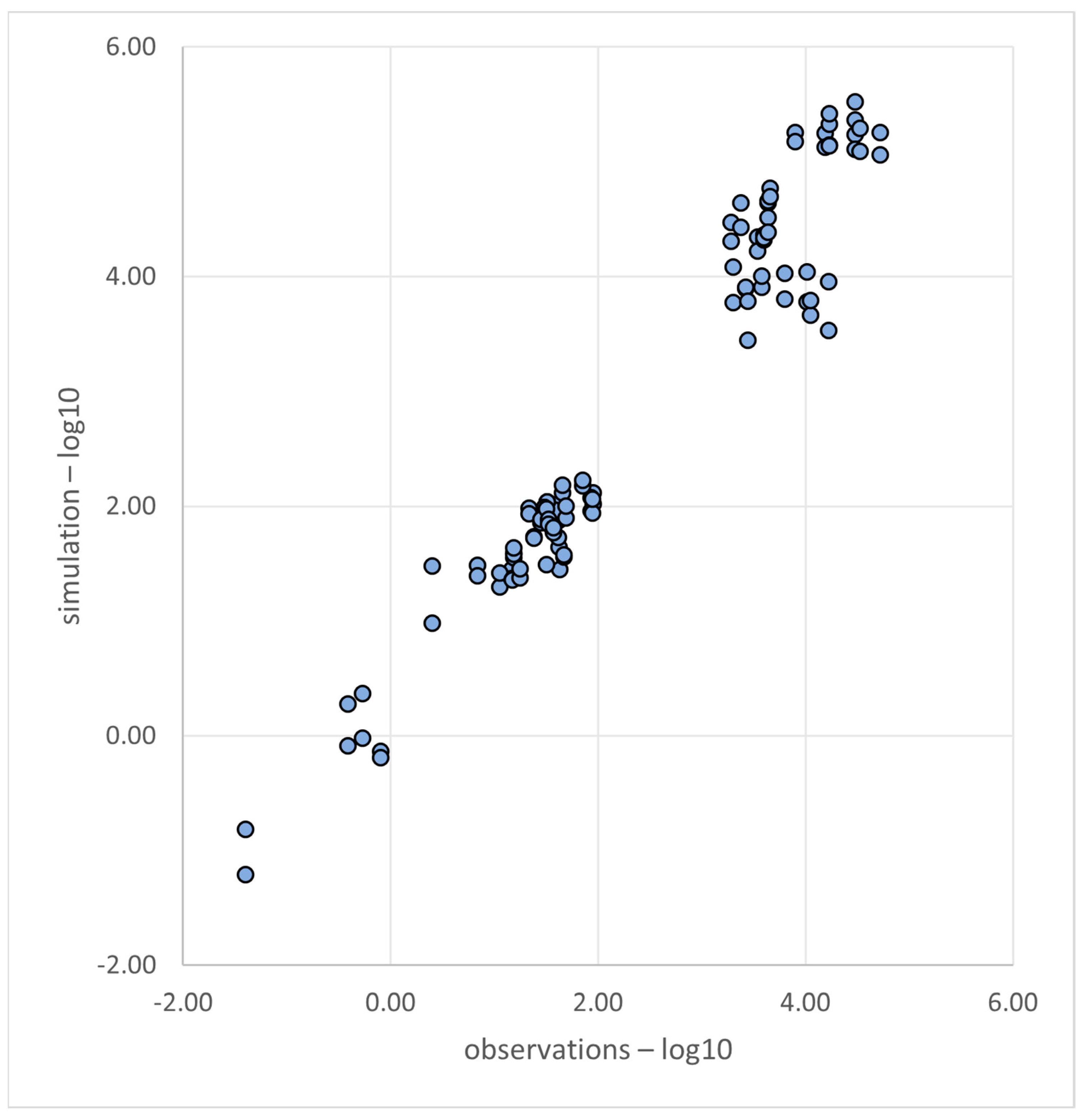
2 = 0.67, RMSE = 1.151, KGE = 0.774. The obtained linear function coefficients show a major influence of urban areas and pastures on the levels of contamination with heavy metals observed in suspended sediments and a minor contribution of the agricultural areas.
Figure 4 presents the fit between the model results and the modelling results obtained following the application of the fingerprinting procedure.
4. Discussion
The results demonstrated varied contamination of soils in the studied catchment, with 78.8% samples classified in the lowest classes of Igeo or EF. Geochemical background values were exceeded in 42.4%, 32.4%, and 50.0% of all samples for AGRO, PAST, and URBAN categories, respectively. High Igeo or EF (above 4) categories were observed in similar numbers across all land-use categories (below 2.5% of all samples). Samples with index values representing heavily to extreme contaminated soil were observed in two samples and concerned high Hg concentrations.
High contamination level (above geochemical background values) was recorded for Hg in 27 samples (75% of all Hg determinations). Igeo and EF classes for this element reached maximum values. The concentration levels of this element in some samples were significantly higher than the geochemical background levels and were up to 80 times higher than the reference values. These values were recurrent at the same measurement points during different surveys and were confirmed using blank samples that excluded measurement errors. The maximum absolute value of this element was observed in the AGRO land-type category and reached 8.88 mg·kg−1. The Nurzec River catchment area is used mainly as an agricultural area, with minor industrial emission sites.
Industrial activity represents the main source of Hg in soil, but recent studies indicate that Hg losses on agricultural lands are relatively high due to higher erosion and historical Hg pollution, including plant protection products (pesticides) [
4]. High values of Hg in this area can also be found in biota, with a mean value of 25 µg·kg
−1 (above the environmental quality standard, EQS). Nevertheless, water monitoring tests did not reveal any excessive values for Hg [
26]. But since the performed statistical test did not confirm any statistically significant differences between the individual land-type use categories, Hg was not used in the fingerprinting procedure.
Another element that was found in higher concentrations in almost all samples along the studied river catchment was Zn. Concentrations above the geochemical background value were found in almost all samples (95%). In total, 55% of samples of Zn had I
geo or EF higher than minimum. The moderate enrichment of Zn was observed more frequently in samples from the URBAN category, where I
geo or EF reached the third class of enrichment. Its range varied between 44.5–367 mg·kg
−1, which represented up to 612% of the geochemical background value. However, these values are not considered to be environmentally hazardous [
23].
The fingerprinting procedure, used as a tool to discriminate sources of heavy metal pollution within the Nurzec River catchment, enabled the development of a model equation that reflects the concentration values observed at the measurement point of the suspended sediments at a satisfactorily level (r
2 = 0.67, RMSE = 1.151, KGE = 0.774). The coefficients obtained using the equation indicated the high influence of URBAN and PAST land categories on the level of heavy metal contamination in suspended sediments in the Otapy section. Agricultural type of land with a calculated discriminant function coefficient = −0.0202849 indicates the minor influence of this land-type category on the level of contamination of suspended sediments. Among the elements that remained after the final selection and were considered for the fingerprinting procedure, the highest concentration levels were observed among the samples from PAST areas. The soil structure of areas along the river is of peaty origin. These areas are not suitable for the growing of permanent crops, but they could act as a natural riparian zone between AGRO lands and the riverbed, to reduce the transport of some pollutants. Additionally, high concentration levels in soils from PAST areas could enhance the statistical correlation between the soil and suspended sediment concentrations. Some studies have confirmed that heavy metals may be of agricultural origin and their source may be fertilization [
27,
28], which represents the second possible cause of the presence of heavy metals in the Nurzec River catchment area.
A fingerprinting procedure based on the combination of statistical tests [
9,
29] successfully eliminated any elements that did not demonstrate any statistical differences among the individual land-use categories and between selected measuring points. The final set of 14 elements allowed the author to develop a model equation with satisfactory goodness-of-fit measure values. However, since the initial set consisted of 31 chemical elements, only 45% of the analysed heavy metals were suitable to perform further analysis. Smaller sets of elements may not be sufficient for this method, especially in heavily polluted areas. The application of fewer markers may produce a dataset without any significant differences between all markers, which is necessary for the fingerprinting procedure. Hg pollution was common and significant in the Nurzec River catchment. In comparison with the results of the geochemical index of enrichment values, the set of fingerprinting markers included four heavy metals: Cr, Cu, Ni, and Pb. The levels of contamination with each element within the analysed catchment were highly variable (from uncontaminated to extremely contaminated), but high heavy metal concentration levels were observed in individual samples. The general results of the study are shown in
Figure 5.
Data obtained in this analysis can be effectively used for the tracking of pollutants transported with the suspended sediment. The knowledge of the structure of geochemical pollutants within the catchment allows us to combine these results with information on sediment load obtained not only from monitoring, but also via mathematical modelling. Sediment is one of the basic water quality parameters calculated as part of mathematical modelling [
30,
31]. The calibration of the model for the amount of suspended sediment is performed right after the hydrological calibration of the model. However, modelling provides information only on sediment load transported via a watercourse, while information on adsorbed compounds is not available [
32]. Thus, by combining information obtained from field studies with information from mathematical modelling, new quality could be added to the results of the analysis. A similar approach has been successfully used to carry out similar analyses of mountain river catchments, where erosion is much stronger [
9]. Nevertheless, the application of a similar analysis to lowland areas, in an extremely homogeneous catchment in terms of land use, will make such an analysis even more valuable. It confirms the proper adjustment of the model for tracking the transport of suspended sediment in such conditions.
The study also confirmed the validity of using the so-called hybrid approach introduced by the author in previous publications. In this case, the hybrid approach combines the aspect of field research with the use of a statistical model. The approach originally proposed for the analysis of sources of nutrients is also effective in wider applications, e.g., with heavy metal contamination. It facilitated the classification of the current state of heavy metal contamination of soils and sediments in the Nurzec River catchment, as well as the identification of its sources. The implemented measurement method is simple and does not require any complicated equipment or time-consuming maintenance, while the applied statistical model is easy to reproduce. The advantages are significant on the catchment scale. However, it must be said that the implemented sampling method has limitations, mainly logistic ones—in the case of larger watercourses, the selection of a representative measuring point could be challenging. It should be noted that other studies on the impact of land use categories on heavy metal contamination provide insight on the discussed topic. Agricultural areas remain polluted with heavy metals across Europe. Sources of this pollution are associated with areas of metal ore mining. Poland is relatively unpolluted and has a low content of heavy metals in soils, in comparison with other European countries [
2,
4,
5].
The limitation of this study is that even though it predicts the pathways and spatial sources of heavy metal pollution, it does not enable the tracking of source-specific markers. Identification is based on the sensitivity analysis, where Discriminant Function Coefficients enable the identification of a set of the most sensitive parameters. Those parameters are classified using the land-use criterion, which allows the identification of a particular area (Hot Spot). In this study, for example, fingerprinting identified pasture and urban areas as the main source of heavy metal transport. However, the question of whether this pollution originates directly from, for example, cattle grazing, or atmospheric deposition remains unresolved. This necessitates further analysis and does not eliminate the need for a proper input/output inventory in a given catchment area. The device’s design itself is an additional limitation: using it to examine larger streams may require additional equipment, which complicates its application.
The general outcome of the study will provide additional knowledge on the transport of heavy metal pollutants within the Nurzec River catchment to the local authorities, residents and NGOs. Varied level of contamination of soils with heavy metals within the river catchment was confirmed and the transport of these pollutants has been proven. The observed contamination of suspended sediments is higher than the observed contamination of all types of land use in the catchment and indicates geo-accumulation of heavy metals. In addition, it demonstrates the significant impact of urban areas on water quality, even in an area with a low population density. It is therefore important to take appropriate actions at the local level and to consider the possibility of remediation in these areas, since anthropogenic heavy metal contamination can affect even the most pristine environments, such as national parks [
33]. This analysis may serve as a basis for the future implementation of projects aimed at the restoration of contaminated areas and the maintenance of a sustainable environmental economy in the catchment area.


