Review

The Rhine Catchment: A Review of Sediment-Related Knowledge, Monitoring, and a Future Research Perspective

1
Institute of Hydraulic Engineering and River Research, Department of Water, Atmosphere and Environment, University of Natural Resources and Life Sciences, 1200 Vienna, Austria
2
Christian Doppler Laboratory for Sediment Research and Management, 1200 Vienna, Austria
3
Blueland Consultancy, 3512 LS Utrecht, The Netherlands
*
Author to whom correspondence should be addressed.
Water 2024, 16(8), 1121; https://doi.org/10.3390/w16081121
Submission received: 25 March 2024 / Revised: 11 April 2024 / Accepted: 12 April 2024 / Published: 15 April 2024
(This article belongs to the Special Issue Rivers - Connecting Mountains and Coasts)

Abstract

:
The Rhine River is affected by major human interventions affecting its morphology and sediment regime, which have severely changed its flow and sediment transport. While channelization has increased the sediment transport capacity in the free-flowing sections, the sediment retention behind dams has caused a bedload deficit downstream and has additionally intensified riverbed erosion. The resulting consequences range from the exposure of less erodible sediment layers that pose obstacles for navigation, to the scouring of infrastructure, the lowering of groundwater levels, and multiple negative ecological consequences. To optimize the efficiency of countermeasures, a coherent overview of all sediment-related activities and the state of knowledge on the Rhine catchment is required. That is why the present study aims to give a catchment-wide overview in this regard, identify knowledge gaps and proposing a future research programme. The methodological approach includes a comprehensive literature review and online interviews with experts from six riparian countries working in the fields of sediment research and management. Based on our investigations, we have derived several research topics, each consisting of research questions. Three project ideas were defined that should primarily be realized: (i) the influence of climate change and land use change on the sediment regime; (ii) alteration and improvement of the sediment balance and continuity, sediment transport, and morphology; and (iii) national and bilateral projects on sediment transport processes and management.

1. Introduction

Sediment management in rivers and in their catchments has been broadly discussed in the research in recent years and is addressed nowadays even more due to increasing sediment-related problems in river systems [1,2,3,4]. Today’s disturbed sediment balance results from a variety of past human interventions, such as dam construction, channelization, sediment mining, or deforestation [5] and has major effects on the multiple claims for use of rivers; these being hydropower, flood control, and navigation [6,7,8]. In the past, river engineering led to comprehensive changes to morphological and hydraulic parameters (e.g., river width and depth, longitudinal and lateral connectivity, flow velocity, shear stress, bed slope) and, most importantly, it affected the sediment budget of rivers by provoking river sections either to have too much or too little sediment, thus causing sedimentation or erosion processes [9]. Finally, this sediment imbalance is causing a vast number of consequences such as increased flood risk [10], less storage volume in reservoirs of hydropower plants [11], insufficient water depth for navigation [12], or the degradation of habitat conditions [13].
In relation to sediment management, the Commission for the Hydrology of the Rhine Basin (CHR) plays a key role through providing a scientific knowledge basis for the participating countries: Austria, Switzerland (also representing Liechtenstein), Germany, France, Luxembourg, and The Netherlands. Founded in 1970, their main tasks are to enhance transboundary knowledge development in the field of hydrology in the entire Rhine catchment and support technically oriented institutions, such as the International Commission for the Protection of the Rhine (ICPR) and the Commission for the Navigation of the Rhine (CCNR), in implementing guidelines, policy, management, and decision-making [14,15,16].
The construction of hydropower plants is one of the main drivers that had a major impact on the sediment fluxes from land to ocean by trapping sediments in reservoirs and impounded sections. Syvitsky et al. [17] estimated a land–ocean sediment flux of 12.6 Bty−1 globally. This corresponds to a reduction of 22.2% when comparing it to an estimated sediment flux in the absence of reservoirs of 16.2 Bty−1. According to Wang et al. [18], for instance, the sediment load of the Yellow River in China has decreased from 1.08 Gty−1 between 1969 and 1985 to around 0.15 Gty−1 in the early years of the 21st century. The reduction in both the sediment load and the annual runoff in the last 50 years is accounted for by climate change effects (reduced precipitation in the catchment) but primarily by human activities such as water abstraction for agricultural purposes and the building of reservoirs [18]. A similar trend was observed at the Chao Phraya River in Thailand, where the annual sediment load changed from 28 Mty−1 in the 1960s to 6 Mty−1 in the 1990s due to the installation of numerous dams and irrigation structures [5].
Habersack et al. [19] conducted a comprehensive study in the Danube catchment by investigating the key drivers and the resulting impacts of past anthropogenic activities on the sediment balance of the Danube River. By stating that the alteration of the sediment balance is a significant water management issue in the Danube River Basin, they found out that the total suspended sediment input into to the Danube delta and the Black Sea was reduced by 60% when comparing the suspended sediment load nowadays with the period prior to the hydropower construction. Another outcome of this study was that 34% of the Danube River length is dominated by sedimentation while 29% shows an erosional trend (excluding data for the lower Danube) due to the lack of longitudinal sediment continuity [19].
In the past, river channelization was a prominent measure to improve navigation and flood control [20]. Several engineering measures have been implemented in Europe and North America in the 19th century with the objective to fulfil, for instance, shipping demands [21,22]. The prevention of lateral erosion processes through bank protection aimed at land reclamation for agricultural purposes but also disconnected the main channel from the floodplain and, thus, reduced inundation frequencies [23]. By forcing braiding river system into one uniform river channel, the fluvial morphology and hydraulic parameters, such as flow velocities and sediment transport capacities, were altered comprehensively. For instance, in France and Austria, braiding river sections decreased by 70% and 95% in total length, respectively [24]. The resulting bed incision did not only affect morphology but also degraded habitat quality by provoking less habitat complexity in uniformed riverbeds [25].
Sediment mining is another key driver of today’s changes in the sediment load. In the middle and lower Yangtze catchment, for instance, sand extraction has become an important industry since the late 1980s. There, Chen et al. [26] estimated that 80 Mty−1 were dredged in the 1990s while 110 Mty−1 were removed from the total Yangtze River system at the beginning of the 21st century [27]. According to Habersack et al. [19], the dredging volume of the Danube River in the period 1971 to 2016 amounted to approx. 400 million m3, of which a substantial amount was used for construction purposes. Since 2006, 30% of the dredged volume is dumped back into the Danube [19].
Besides these manmade influences, climate change also has its share in recent developments in connection with the sediment budget [28]. While it is difficult to disentangle the impacts of climate change from consequences resulting from anthropogenic interventions, the latter is considered to be more significant [5]. Studies also suggest a considerable impact of climate change on the sediment load of the world’s rivers. For the 300 km long transboundary reach of the Rhine River between Bonn and Vuren, Ylla Arbós et al. [29] compared the channel response to climate change with the channel response to human interventions. The results showed that human interventions will be predominantly responsible for bed incision until 2100. However, their impacts will decrease while impacts from climate change will increase their share mainly through provoking sea level rise and hydrograph changes, with the latter causing increased riverbed erosion. In respect to the sediment load, the outlook for future developments in the context of climate change either predicts an increase or decrease in the sediment load. On the one hand, studies project a mean decrease in sediment flux to the 47 major river deltas of 38% (2500 Mty−1) by the end of the 21st century due to the effects of anthropogenic activities (land use changes and dam construction) overwhelming those of climate change [30]. On the other hand, increasing permafrost thawing could cause the exposure of large areas and, thus, the provision of new sediment sources [31].
The Rhine River and its catchment do not represent an exception in the context of the above-mentioned anthropogenic and climate change impacts, nor in terms of the resulting consequences for morphology, ecology, and the sediment budget. Frings et al. [32] published a catchment-wide study on morphodynamics by quantifying sediment fluxes of the different fractions of clay, silt, sand, gravel, and cobbles based on a huge dataset. However, their study and the current scientific state of knowledge lacked a detailed overview of sediment-related problems and also needs a future research perspective for the entire Rhine catchment. Also, some publications on sediment research exist, but they only cover individual river sections of the Rhine (e.g., [33,34,35,36]) and not the entire Rhine catchment. That is why the present paper aims to (i) give a catchment-wide overview of sediment-related issues in the Rhine and its main tributaries, (ii) outline research and monitoring activities, (iii) identify existing knowledge gaps, and (iv) propose a future research programme at the catchment scale. Also, in relation to the Rhine 2040 programme which, among others, aims to establish an integral sediment management plan by 2026 [37], the present publication can constitute a substantial knowledge base.

2. Methods

The methodological approach involved a comprehensive literature review on sediment-related aspects in the Rhine catchment. In addition, we consulted experts from six riparian countries working in sediment research to learn about their experiences during online interviews with the following structured questionnaire:
  • What projects/studies/research programmes are performed in the past/currently/planned in the future regarding sediment management?
  • What are the problems/threats/issues in that river section causing negative impacts on the river system (in terms of morphodynamics, flood protection, navigation, ecology, etc.)?
  • What knowledge gaps do exist in this context?
  • Do you have any proposals/recommendations for future research activities concerning improvements for the riverine system (in terms of sediment management and morphodynamics)?
  • Can you provide literature (reports, scientific publications, website links, etc.)?
We interviewed 22 individuals from Austria, France, Germany, Luxembourg, The Netherlands, and Switzerland about sediment-related issues, sediment management activities and knowledge gaps, and about monitoring strategies. The interview partners were selected according to their relevance, which we identified during the literature review and included people from different sectors such as academic research, government agencies, hydropower operation, and environmental consultancy. In the end, the literature review, together with the outcome from the interviews, served as a basis for the elaboration of the present paper.

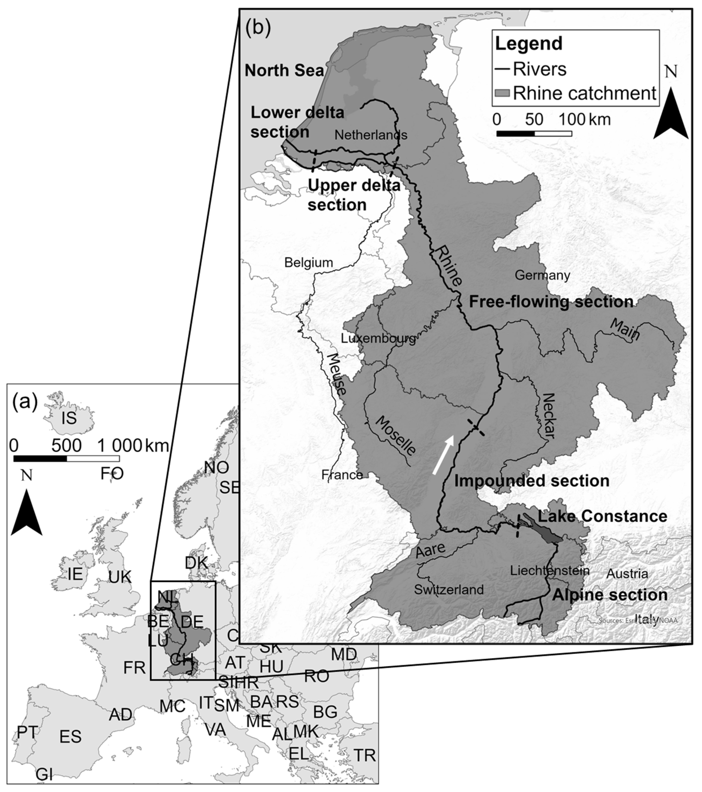
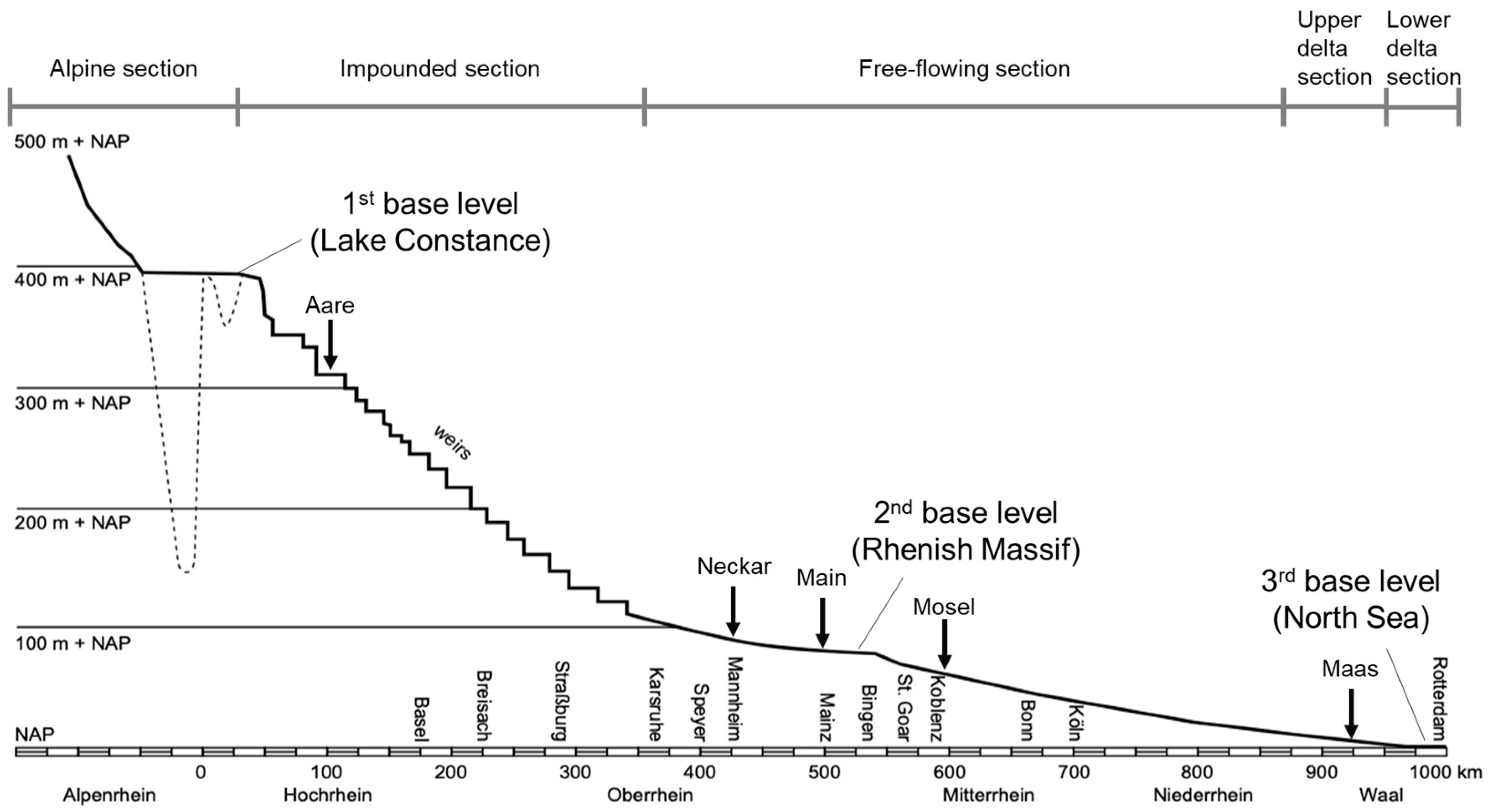
3. General Setting of the Rhine River System

The objective of this chapter is to present a holistic characterization of the overall Rhine River system, describing the key aspects that affect morphology and sediment transport in the entire catchment.
The Rhine River has its sources in the Swiss Alps, where the two headwater streams Vorderrhein and Hinterrhein form the so-called Alpenrhein at the town of Reichenau. On its way to the mouth into the North Sea near Rotterdam, the river covers a total length of 1232.7 km, draining a catchment area of 185,000 km2 in nine different countries (Figure 1) [32]. With a mean discharge of about 2300 m3s−1 at the Rees gauging station near the German–Dutch border, the Rhine ranks ninth in terms of the largest Eurasian rivers [38]. Compared to the share of the global river water of 0.18% (based on numbers of Syvitsky et al. [17] and Frings et al. [32]), the actual sediment load contribution is disproportionally small. Syvitsky et al. [17] report a global sediment input of rivers into oceans of 12.61 Bty−1. For the Rhine River, the sediment delivery into the North Sea amounts to only 1.25 Mty−1 [32], which corresponds to 0.01% of the global sediment supply. The low sediment yield of 6.8 km−1y−1 is primarily caused by the special basin characteristics of Lake Constance, which forms a natural sediment trap (see below) [32].
According to the different morphological and sediment transport characteristics along the Rhine River, we distinguished between five morphological sections in the longitudinal direction: (i) the Alpine section, (ii) the impounded section, (iii) the free-flowing section, (iv) the upper delta section, and (v) the lower delta section. This distinction corresponds to the one made by Hillebrand and Frings [39], but additionally separates the upper and lower delta sections due to effects resulting from tidal currents and upstream transport and deposition of marine sediments in the lower delta. Figure 2 presents the longitudinal profile of the Rhine River, indicating these morphological sections. Additional subdivisions in each of these sections are made according to geographical characteristics. Vorderrhein and Hinterrhein merge the Alpenrhein, which is part of the Alpine section. The impounded section consists of the Hochrhein (the high Rhine) and the upstream part of the Oberrhein (the upper Rhine). The downstream part of the Oberrhein, the Mittelrhein (the middle Rhine), and the Niederrhein (the lower Rhine) represent the free-flowing section. The main tributaries along the Rhine are the Aare, Neckar, Main, Mosel, and Maas.
When looking at the longitudinal profile of the Rhine, three major natural base levels can be identified, which affect the morphology by continuously provoking a reduced bed slope and sediment transport capacity. The first one is Lake Constance, which represents a naturally formed sediment trap disconnecting the impounded section from the Alpine section [32]. According to [38], the second base level is the Rhenish Massif, an area of uplift that was formed between two areas of subsidence. In the lower delta section, the Rhine enters the North Sea, which represents the third base level. Upstream of these three base levels, the Rhine attempts to form a concave riverbed gradient due to sediment deposition downstream and erosion upstream [38].
From a holistic perspective, the Rhine catchment is characterized by a lack of sediment transport continuity. Besides the specific characteristics of Lake Constance acting as a natural sediment trap, 21 dams in the main channel of the Rhine, as well as barriers in the main tributaries, interrupt the continuous transfer of coarser sediments [32]. According to Frings et al. [30], the sediment supply by tributaries shows negligible amounts of gravel and cobbles, small amounts of sand, and major loads of silt and clay.
Another key aspect is the degradation of the riverbed resulting from large-scale human interventions in the past. In Germany, these interventions started in 1817 with river channelization measures in the Oberrhein (Oberrheinkorrektion), which were initiated by the German engineer Tulla [40]. These measures were aimed at land reclamation, the definition of the German-French border, and improving flood protection. These measures shortened the river length, narrowed the river width, increased the bed slope, and, thus, substantially changed the morphology of the Rhine River [38]. Furthermore, the original width of the river system of 3.5 km was reduced to 200–250 m causing bed erosion of up to 7 cmy−1 in the period from 1880 to 1950 [41]. In The Netherlands, human interventions started in 1707 with the construction of the Pannerden Canal, a 3 km long and 130 m wide canal for navigation, connecting the Rhine main channel with the Nederrijn [42]. These interventions were followed by comprehensive river regulation measures that were started by Ferrand and Van der Kun in the 1850s and were finished in the 1930s [43].
River channelization and the resulting bed erosion and accretion of floodplains led to the disconnection of floodplains from the main channel in the upper [44] and lower river stretches [45]. Consequently, floodplain inundation was reduced, leading to a massive loss of biodiversity [46].
The coarsening of the riverbed in the free-flowing and delta sections is something that is associated with higher transport rates of sand material compared to gravel. For the period 1991–2001, Frings et al. [32] reported that the sand content in the free-flowing section decreased by 1.142 Mty−1, while the gravel mass increased by 0.475 Mty−1.
Gravel nourishments to restore river ecology and control bed erosion are taking place in the impounded section and in the free-flowing section. Only the latter are relevant for sediment transport and morphodynamics since they are by far more substantial than the nourishments in the impounded section [32].
The annual load of fine sediments at the German–Dutch border used to be 4 Mty−1 in 1950 [39] but has decreased to 1.2 Mty−1, according to the latest numbers by Van der Perk et al. [47]. Fine sediments play a crucial role in terms of floodplain sedimentation and maintenance dredging in the lower delta section. The reasons for this strong reduction and the effects on morphodynamics downstream are not yet clear [3].
Finally, future sediment-related challenges will arise from projected effects of climate change. These effects will manifest through changes in the discharge regime, which will change from a snowmelt–rainfed mix into a dominantly rainfed regime [48]. Low discharges will become lower and last longer, affecting navigation through restrictions during low-water periods, while the frequency and peak of high discharges will increase. Sea level rise will affect the lower delta section through the upstream transport of sediments until they deposit and gradually change the riverbed profile in this section [3]. For the entire Rhine–Meuse delta, Cox et al. [36] predict a net annual sediment loss of −8 to −16 Mty−1 by 2050 and −11 to −25 Mty−1 by 2085, depending on the climate scenario and uncertainties in the calculations. This budget deficit is mainly due to immense dredging in harbours. However, there are also sections with insufficient sediments, indicating the uneven and unfavourable distribution of sediments in the delta [36].

4. The Alpine Section

4.1. Setting the Scene

Comprehensive river engineering works started in the middle of the 19th century [49] and included channelization, the construction of embankments and three block ramps, and meander cut-offs [26]. Consequently, the river length was reduced by 10 km, which increased the bedload transport capacity and led to bed level incision of up to 4 m [50]. At a distance of 90 km from the source, the Rhine enters Lake Constance, where the so-called “Vorstreckung” (a 4.8 km long jetty) was constructed in the first half of the 20th century with the intention of improving flood protection. Massive fine sediment deposition in this section, however, had the opposite effect, leading to severe flooding [50]. Between the town of Reichenau and the mouth at Lake Constance, the riverbed width varies between 40 m and 300 m with a decreasing bed slope from 0.35% to 0.1% [51]. The discharge regime in the Alpenrhein is snowmelt-dominated with the highest discharges occurring in June and a mean discharge at the inflow into Lake Constance of 230 m3s−1 [51]. Today, only 1.4% of the 6123 km2 catchment area are occupied by glaciers, which will further decrease in the future and will affect the hydrological regime [38].

4.2. Sediment-Related Issues and Corresponding Research and Management Activities

According to Dietsche [52], sediment mining was strongly performed between 1940 and 1970 with the intention to control flood risk but started to endanger the stability of levees and bridge piers. Today, dredging for reasons of flood protection and gravel mining has been considerably reduced and is restricted to the outflow into Lake Constance (“Vorstreckung”), to the confluence of the Vorder and Hinterrhein, and to the mouth of the tributaries the Landquart and Plessur [39]. The sediment retention in the Alpine catchment due to several dams has been causing sedimentation problems in reservoirs over the last 30–50 years [53]. According to Gökler [53], sedimentation is endangering hydropower plant operation both in run-of-river and storage power plants since the flushing of the deposited bedload material is not allowed. Several hydropower installations exist in the tributaries of the Alpine catchment, which induce local impacts (sedimentation upstream and erosion downstream) and prevent coarse sediment supply into the Rhine River [38].
Past river training measures in the Alpenrhein that aimed to reduce floodings have led to the opposite effect by increasing sediment transport capacities and causing riverbed erosion in the upstream section and bed level increase in the downstream section [54,55]. Channelization measures changed the once braided river system into a narrowed single river channel (Figure 3). As a result, continuous riverbed erosion in the section between Reichenau and Liechtenstein is jeopardizing the stability of bank protection structures [56], while, at the mouth near Lake Constance, sedimentation poses a threat to flood safety and, thus, requires gravel dredging [57].
In order to counteract bed degradation, sediment-related activities focus on river restoration to improve both flood control and the morphological status of the Alpenrhein. With the comprehensive flood protection project “Rhesi”, the “Internationale Rheinregulierung (IRR)” aims to increase the discharge capacity at the mouth of the Alpenrhein from its current 3100 m3s−1 to 4300 m3s−1 (HQ300) by widening the river width within the current levees from 70 m to 120–300 m [58]. The “Entwicklungskonzept Alpenrhein” is an initiative of the IRR and the “Internationalen Regierungskommission Alpenrhein (IRKA)” with the purpose not only of improving flood protection in the middle and lower “Rheintal” but also of improving groundwater conditions, ecology, and recreational values [59]. As part of the “Entwicklungskonzept Alpenrhein”, the river-widening project between the towns of Maienfeld and Bad Ragaz aims to increase the river width from its current ca. 85 m to a maximum width of 230 m along a 3 km river stretch [60]. By relocating the existing levees further away from the river, this restoration measure will help to counteract bed level degradation and groundwater-level lowering, as well as to enhance morphodynamics and the development of spawning habitats [60]. During the talks, experts from the riparian countries concluded that successful restoration measures strongly depend on the river width (for the Alpenrhein, the target value is at least 150 m) and the length of the widened stretch [55]. Also, they argue that restoration measures can be most beneficial when river widenings are combined with the implementation of instream structures such as gravel bars, since these structures present obstacles that provoke different flow velocities and, thus, enhance morphodynamics [52,55].
Bedload management and morphology aiming to stabilize riverbed levels and to improve the longitudinal continuity of bedload transport rank high on the research agenda. According to Zarn [55] and Weitbrecht [61], there is an ongoing discussion about the “appropriate” amount of bedload needed to achieve near-natural morphodynamics. Measures to increase bedload continuity include nourishments downstream of dams and artificial floods to mobilize gravel [55]. For the nourishments, sediments are either gained from gravel pits nearby (cheaper) or from dredging in reservoirs. Where appropriate, gravel is flushed through run-of-river hydropower plants during flood events [53]. Drawdown flushing is tested only at run-of-river hydropower plants with smaller reservoirs since it is not possible to sufficiently flush sediments through large storage power plants in the Alpine catchment [62]. Reiterer [63] mentioned that periodic dredging is performed upstream of check dams and at the head of impoundments in order to maintain hydropower operability. Studies on bedload management are strongly performed in the Alpine catchment. The Laboratory of Hydraulics, Hydrology, and Glaciology of ETH Zurich is conducting several projects on bedload dynamics by combining physical with numerical modelling [61]. Studies showed that the restoration measures increased the discharge capacity while at the same time indicating that the longitudinal bed profile is currently not in an equilibrium state and will be subject to even larger changes in the future [51]. In this context, the numerical 1D model MORMO [64,65] helps to project the future development of bedload transport and morphology and their response to the impacts of hydropower plants, discharge changes, river engineering, gravel mining, and changes to bedload input [66].
The interaction between vegetation and fine sediment deposition is another topic that is causing challenges for river managers and, thus, is increasingly addressed in the research. At the moment, fine sediment depositions on floodplains and along the inner riverbanks are dredged and dumped back into the Alpenrhein [61]. Without such sediment management, fine sediment deposition would benefit the emergence of vegetation and eventually increase flood risk. Vegetation growth on gravel bars can also affect flood protection since it presents an obstacle for the water flow causing higher flood levels. According to Hunziker, Zarn, and Partner AG [67], the vegetation growth could be associated with increased bed degradation through reduced overflow of gravel bars because of lower bed levels and the absence of higher flood events.

4.3. Inventory of Monitoring Activities

The Federal Office for the Environment (FOEN) operates a monitoring network for sediment transport in Switzerland including 100 bedload traps, which are distributed all over the country [68]. Suspended sediment transport has been monitored since the 1960s, with samplings being carried out twice a week. Currently, at two monitoring stations, suspended sediment concentrations are recorded continuously to determine annual suspended sediment loads in the Alpenrhein [57]. Specific monitoring activities are conducted to regularly gather information on the transported suspended solids (including flow velocity and discharge measurements to determine the sediment load) while turbidity monitoring stations deliver continuous data on the suspended sediment concentrations [68].
To detect excessive sedimentation of gravel, the riverbed level of the last 30 km of the Alpenrhein and in the “Vorstreckung” is measured with a single beam device every second year and every ten years, respectively [57].

5. The Impounded Section

5.1. Setting the Scene

The impounded section starts at the outflow of Lake Constance (rkm 24) and ends at the most downstream hydropower plant Iffezheim (rkm 334). In total, there are 21 dams located in the impounded river section, which were installed between 1898 and 1977 [69]. Commercial navigation starts downstream of the city of Basel [32]. With 292 million tons of goods being transported between Basel and the North Sea in 2022, commercial navigation presents a crucial economic aspect of the Rhine [70]. Between rkm 174 and rkm 224, an artificial canal called the Grand Canal d’Alsace was constructed between 1928 and 1959 [71]. It runs parallel to the original Rhine, which is called the Old Rhine in this section and forms the border between Germany and France. The purpose of the construction was to install hydropower plants and to improve navigation in the 130 m wide and 9 m deep canal [38]. The Oberrhein was subject to substantial engineering works, which started in 1817 according plans by the hydraulic engineer Tulla and involved meander cut-offs reducing the river length between Basel and Worms by 23% [38] as well as the construction of groynes and bank protection structures to stabilize the riverbanks. Flow regulation dams were built to ensure a water depth of ca. 2 m during low flow conditions [39]. According to Arnaud et al. [71], the purposes of these measures was to initiate bed erosion and the subsequent reduction of channel overflow, maintain flood control, define the border, and create space for agricultural production. The once 3.5 km wide meandering and braiding river system was changed into a 200 m wide single river channel in this section [71].

5.2. Sediment-Related Issues and the Corresponding Research and Management Activities

Widespread impacts on morphology and sediment transport have resulted from large-scale river engineering between the 18th and 20th century (see Section 5.1). Although the primary goal of these measures was to reduce the risk of flooding [38], strong bed erosion processes occurred, which continued until the construction of hydropower plants began [72,73]. According to Uehlinger et al. [38], the erosion even reached the bedrock layer and impeded navigation between Mannheim and Basel. Also, the former frequently inundated floodplains changed into arable land, which now require irrigation in order to ensure agricultural productivity. That is why the Integrated Rhine Programme focused on improving flood protection by enabling frequent inundations of floodplains and reconnecting former side channels. According to Schmitt et al. [74] and Commission Permanente [75], measures included the construction of flood retention areas, the lowering of floodplains, adjustments to hydropower operations, and the closing of agricultural dams.
The construction of 21 dams (Figure 4) turned the former naturally degrading and braiding river system into a series of impoundments, which interrupts the transport of gravel and allows only fine sand, silt, and clay to enter the free-flowing section downstream [39]. Dam-regulated tributaries additionally limit coarse sediment supply [38]. To improve bedload continuity in the impounded section, research activities and measures are focused on the development of a masterplan that includes measures such as gravel nourishments, temporal reservoir drawdown, or the removal of bedload traps [76]. Nourishments downstream of hydropower plants are preferably performed with sediments dredged from reservoirs. This is carried out, for example, from a hydropower plant in the tributary Aare, which is an important sediment supplier [62]. Also, in the tributary Aare, a strategy was developed that addresses the bedload budget, fish migration, restoration, and the watercourse corridor [77]. For the Hochrhein, Switzerland aims to restore bedload transport by 2030 at 150 hydropower plants and 350 other installations such as gravel retention basins and commercial gravel dredging sites [62]. Nitsche [62] also mentioned that several nourishment measures are performed downstream of hydropower plants, for which companies do not use deposited sediments from impoundments but from nearby gravel pits because of lower costs. These measures come with high maintenance efforts and do not represent a long-term solution. That is why studies focus on how to restore bedload continuity more efficiently by slowly lowering the water level in the impoundment during flood events over a longer period of time and, thus, transporting bedload through the impoundment [62]. This innovative management approach is called bedload drift and represents a suitable option in case of high fine sediment concentrations exceeding permitted limits during flushing procedures [19]. The Federal Office for the Environment in Bern (BAFU) supervises such studies by performing numerical modelling on how to perform flushing most effectively in terms of timing, duration, and drawdown level, as well as on the effects on bank stability, bridge piers, and other infrastructure [62].
In the impounded section of the Oberrhein, sediment deposition at hydropower plants poses no problems in terms of the amount but in terms of pollution since dredged sediments have to be considered as waste and appropriately disposed of once they are excavated from the impoundments [78]. The key aim, especially at the downstream hydropower plant Iffezheim, is to study the possibilities of how to prevent critical flood levels in the impoundments because depositions have critically reduced the freeboards in the river section immediately upstream of the weir [79].
The sediment deficit is responsible for the undermining of bridge piers and the coarsening of the substrate, which consequently affects habitat conditions by, e.g., leading to a lack of spawning grounds [62]. In the Old Rhine, morphological and hydrological conditions have changed in such a way that aquatic habitats were disturbed or even vanished, changing riverine communities and biodiversity [80]. Due to a lack of morphodynamics in this river section, an armoured bed layer formed, which was impossible to mobilize during renaturation tests [81]. That is why river restoration ranks high on the research and management agenda. For instance, in the Oberrhein, more than 140 such measures have been implemented since the 1980s including the construction of fish passes, the reconnection of side channels, ecological floods, the increase of instream flows, artificial gravel nourishments, the removal of bank protection, and the restoration of specific habitats [82]. In 2019, together with German partners, French project leaders initiated the restoration programme “Plan Rhin Vivant”, which aimed to restore ecological functionality more holistically [83]. The University of Strasbourg is conducting several studies on how to implement restoration measures most effectively and on how to assess the hydromorphological and ecological effects of these actions [84,85,86,87,88]. “Électricité de France” (EDF) implemented multiple restoration measures in the Od Rhine with the objective of improving morphological and ecological processes [80,88,89,90,91,92,93,94]. Measures included artificial gravel nourishments, increasing instream flow, removal of bank protections, and groyne rearrangement [88]. The German–French project “Redynamization of the Old Rhine” was implemented between 2009 and 2013 and aimed at initiating morphodynamics in the Old Rhine by artificially adding gravel [95,96]. All these restoration measures came to the conclusion that gravel nourishments should be combined with river widening downstream of the nourishment location in order to reduce shear stresses, to prevent gravel from immediately being transported downstream and to provide space for the development of morphological structures [97,98,99].

5.3. Inventory of Monitoring Activities

According to Hillebrand and Frings [39], the German Federal Waterways and Shipping Administration (WSV) operates more than 30 monitoring stations in the impounded (and free-flowing) section, including the tributaries Neckar, Main, Moselle, and Lahn, where daily (except for weekends) water samples are taken in the water column near the surface to determine the suspended sediment concentration. This monitoring network is now being changed by replacing the water samples with optical sensors that continuously monitor the turbidity [39].
In the Old Rhine, a 6-year interdisciplinary monitoring study was conducted to look at the effects of instream flow increase and gravel nourishment on aquatic and riparian organisms [92]. Chardon et al. [89] tested two possibilities to estimate the grain size distribution of emerged deposits in the Old Rhine including a terrestrial photo-sieving method and an airborne LiDAR topo-bathymetric survey, both of which proved to be reliable techniques. To calibrate both methods, a field pebble count method was applied [89].

6. The Free-Flowing Section

6.1. Setting the Scene

The free-flowing section starts downstream of the last hydropower plant Iffezheim at rkm 334 and extends until rkm 857.5 at the German–Dutch border. Like in the impounded section, this river section was affected by channelization works, which were carried out by Tulla between 1817 and 1867 and aimed to improve flood protection and navigation conditions [38]. These measures increased sediment transport capacities in such a way that bed erosion rates became a major challenge in the downstream section [100]. In addition to channelization measures, gravel dredging, sediment retention in the catchment, and even propeller wash by ships intensified erosion processes [101]. With a decreasing bed slope and a mean diameter of bed surface sediments of 0.4 ‰ to 0.1 ‰ and 17 mm to 2 mm, respectively, the river width increases from about 150 m to 300 m in the downstream direction [34].

6.2. Sediment-Related Issues and Corresponding Research and Management Activities

Long-term bed erosion was the main sediment-related issue in the free-flowing section, which was up to 3 cmy−1 in some river sections but reduced to 1 cmy−1 after 2000 [102]. Past river channelization by Tulla forced the braiding river system into a single river channel (Figure 5), which consequently led to a changed hydraulic radius and a significant decrease in the river width, while the sediment transport capacity was increased. With the disturbed sediment supply from upstream caused by dams, riverbed incision was intensified additionally.
The resulting consequences include limitations for navigation through the exposure of less-erodible bed sediments and for the stability of constructions in and along the Rhine [38]. Groundwater levels are dropping in response to lower water levels in the Rhine River. Today, riverbed levels are stable due to effective sediment nourishments downstream of the hydropower plant Iffezheim [102]. Vollmer [102] reported that sediment nourishment is carried out there adequately but is still constantly optimized in order to keep the riverbed level in the German free-flowing section in an equilibrium state. Since the availability of gravel material for these nourishments might not be unlimited, there are ongoing studies on where to obtain appropriate sediments. According to Kempmann [103], possible sources might be gained from the construction of polders in the Oberrhein or from artificially broken stones obtained from the “Schwarzwald”. Sediment that was dredged from sediment traps was partly withdrawn from the river in the past [39]. Today, all dredged sediments are reintroduced within 10 km from the dredging location [102]. For instance, a sediment trap at Mainz–Weisenau (rkm 494.3) is emptied on a regular basis [39]. While in the period 1991–2010, about 68% was withdrawn from the river [39], today all dredged sediments are dumped in the river downstream [102]. According to Huber [79], the Federal Waterways Engineering and Research Institute (BAW) is advising the Federal Waterways and Shipping administration on how to optimize gravel nourishments in terms of the appropriate amount and grain size distribution of the sediments added. Since the river section downstream of Basel is a major transport carrier for vessels, research activities pay a lot of attention to interactions between sediment dynamics and navigation, also including the effects of climate change. The main objective of the Federal Waterways and Shipping Administration (WSV) is to maintain a balanced sediment budget, which they try to achieve by optimizing river training structures to prevent the formation of shallow river sections and thus, reduce dredging activities [103]. Huber [79] mentioned that, in transboundary cooperation, German and Dutch institutions are investigating the effects of sediment transport and morphology on navigation in the border section of the Rhine and in the Dutch Rhine branches with the objective of developing a joint strategy concerning possible management measures such as gravel nourishments or river training structures. The Federal Ministry for Digital and Transport in Germany [104,105,106] conducted studies on the effects of climate change on waterways and navigation aiming to adapt strategies that ensure safe navigation conditions, water quality, and riverine and coastal habitats. According to these studies and to Hillebrand [78], the future management strategy will have a greater impact on sediment dynamics than the expected hydrologic change induced by climate change.
Sediment input from the tributaries Mosel, Neckar, and Main into the Rhine is limited due to the existence of several barriers. That is why research institutions are looking at to the possibility of increasing sediment connectivity [107,108]. Near the mouth of the Mosel, sediment is artificially added to the Rhine to compensate for the sediment deficit [79].
In the Niederrhein, riverbed erosion has released a lot of sand from the riverbed while at the same time coarse gravel has been deposited [39]. This has contributed to a coarsening of the riverbed by changing the median bed surface grain size (D50) in the Niederrhein from ca. 12 mm to ca. 16 mm [109]. To better understand morphodynamic processes, the German Federal Institute of Hydrology (BfG) and BAW focus on increasing their knowledge on sediment transport processes. In their studies, they investigate, for instance, bedload transport and the formation of riverbed structures by applying novel hydro-acoustic measurement techniques or looking at the sediment porosity of the riverbed by conducting laboratory experiments (including physical models) [110]. The optimization of river training structures (such as groynes or longitudinal structures) to control sediment transport and, consequently, to improve navigation, is another important research item for the scientific institutions BfG and BAW in Germany [79,105]. Multiple applied research projects, including field measurements and numerical and physical models, are conducted to find out, e.g., how groynes can be adjusted so that they positively affect sediment transport processes [79].
The fine sediment load entering from the German section into the Dutch section has reduced over recent decades, which will affect floodplain sedimentation rates, dredging volumes, and water quality [111]. As part of the research programme Rivers2Morrow [112], the supply and origin of fine sediments from the Rhine catchment will be investigated, focusing on the factors that determine fine sediment concentrations and aiming to project future fine sediment input into the Dutch Delta [111].

6.3. Inventory of Monitoring Activities

According to Hillebrand and Frings [39], bedload measurements are carried out three to four times a year at 24 locations in the Ober and Mittelrhein, and at 19 locations in the Niederrhein. With respect to monitoring suspended sediment transport, there exist two long-term datasets. The first ones come from cross-sectional measurements, which are conducted twice a year at about 40 locations in combination with flow velocity measurements to calculate suspended sediment transport [39]. The advantage of these measurements is that the grain size distribution of the suspended sediments in the cross-section can be determined. Information on sediment transport is presented online [113]. The second dataset consists of water samples taken from the upper water column daily, except on weekends, at more than 30 locations to determine the suspended sediment concentration (see Section 5.3).
Hillebrand and Frings [39] reported that the riverbed level in the main channel is surveyed at 100 m intervals every one to two years while floodplain deposition has been measured with Caesium-137 on a project basis.

7. The Upper Delta Section

7.1. Setting the Scene

The upper delta section is characterized by a division of the Rhine (called the Bovenrijn in this section) into three branches. At a point 10 km downstream of the German–Dutch border at rkm 867.5, the Bovenrijn divides into the Waal and the Pannerden Canal [7]. At the IJsselkop bifurcation, another 10 km downstream, the Pannerden Canal splits into the Nederrijn and the IJssel. The IJssel flows northward and enters Lake IJssel. The westward flowing Waal and Nederrijn join near Rotterdam and flow together with the Meuse River into the North Sea. The IJssel and the Waal are free-flowing branches while the Nederrijn is controlled by three weirs, which are used for discharge partitioning and navigation purposes [7]. By carrying about 2/3 of the total Rhine discharge, the Waal is the largest branch in the upper delta section [114]. According to Ten Brinke [7], the Dutch Rhine branches were first affected by large-scale river engineering in the 17th century with consecutive interventions at the end of the 19th century and the beginning of the 20th century.

7.2. Sediment-Related Issues and Corresponding Research and Management Activities

In the river branches of the upper delta section, the riverbed has eroded up to 3 m locally due to widespread river training starting in the 1850s with, e.g., the construction of groynes and levees, meander cut-offs, and ending in the 20th century with channelization measures and the construction of bank protection structures [7]. The change in the bed slope presents the main morphological adjustment resulting mainly from the narrowing and meander cut-offs, which caused bed erosion in the upstream reach and sedimentation in the downstream reach (Figure 6). The reduced bed slope was amplified by large-scale sediment mining in the past [111]. According to Blueland Consultancy [111], riverbed erosion in all branches of the upper Rhine delta (Pannerden Canal, Waal, Nederrijn, Ijssel), except the Bovenrijn, is still present, although erosion rates seem to have reduced. These developments are resulting in restrictions for navigation during periods with low river discharge since the required fairway depth is compromised by the exposure of fixed layers (bedrock), which pose obstacles for vessels [111]. The undermining of bridge piers, cables, and pipes in the subsoil of the riverbed is another potential consequence resulting from intense erosion processes. Therefore, researchers are paying a lot of attention to counteracting bed degradation. The research programme Rivers2Morrow [115] plays a central role by conducting studies on the effects of climate change and sea level rise on the future morphological and hydrological development of the Rhine–Meuse upper delta, including the drivers and measures to mitigate riverbed erosion [111]. The executive agency of the Dutch Ministry of Infrastructure and Water Management is carrying out pilot projects to study how to compensate bed level incision through sediment nourishments on the riverbed in the Bovenrijn and in the groyne fields of the Waal [111]. Blom [116] reported that a pilot study addresses the effects of longitudinal dams along the Waal’s navigation channel to combat bed erosion and improve navigation and ecology on the bank side of the longitudinal dams.
Floodplain deposition is restricted to a small area between the levees, which led to the fact that the depositions have reached very high levels, allowing the floodplains to be flooded only during high discharges [46]. To increase the inundation frequency, sediment dynamics in side channels are addressed to determine the appropriate water inflow into these channels and on floodplains in order not to cause excessive aggradation in the main channel resulting from too much water abstraction but also allowing a minimal inflow, which is needed for ecological reasons [117]. Recent measures, as part of the “Room for the River” programme, have increased discharge capacity by excavating side channels and parts of the floodplain, lowering groynes, and through the construction of side channels and the relocation of levees [111]. These measures have increased the frequency of floodplain inundation but caused the deposition of sand at locations where water flows from the river onto floodplains creating shallows for navigation after flood events and eventually increasing the volumes of maintenance dredging [118]. Sediments dredged in the main channel are no longer withdrawn from the river but, since the mid-1990s, are dumped back into it [111]. Nourishment pilots to reduce bed erosion have been carried out in the Bovenrijn in 2016 and 2019 with sediments from outside the river.
Fine sediment deposition occurs in the excavated side channels [119,120], negatively affecting the discharge capacity and the substrate conditions for aquatic habitats. To maintain the discharge capacity of these channels, it has been proposed to dredge these sediments when the bed level of more than 50% of the riverbed has increased by 10 cm (for channels that are connected to the main channel at both sides) or 20 cm (for channels that are connected to the main channel only at one side) [119].
In the upper delta section, a change in sediment load has also been observed. On the one hand, the amount of sediment input into the upper delta has decreased by 70% [121,122] and, on the other hand, the composition has changed from less sand to more gravel [122]. This is provoking a coarsening of the top layer of the riverbed and a steepening of the bed slope, which was discovered in the Bovenrijn [109,123]. Sediment nourishments in the Niederrhein and the Dutch upper delta section may have impacts on the bed level development because huge amounts have been added since 1989 to counter bed erosion. In the period 1990–2010, 8.4 Mt of sediment was nourished in the Niederrhein, according to Ylla Arbós et al. [109].
Another issue is the downstream fining of sediments, also known as the gravel transition zone, which increased its length in the Bovenrijn/Waal from 50 km in 1997 to 90 km in 2020 and moved downstream by ca. 20 km [3].
The development of bed forms, such as dunes, is causing consequences for flood safety and navigability under climate change (increasing drought periods) and is therefore increasingly addressed in the research since this affects bed roughness and can eventually contribute to shallows for shipping [111,124,125].

7.3. Inventory of Monitoring Activities

While no bedload measurements have been carried out in recent years, suspended sediment concentration is measured continuously at Lobith (rkm 861.5) [111]. The riverbed level of the navigation channel in the upper delta section is measured on a biweekly basis while the riverbed level of the entire main channel is surveyed twice a year [120]. Once every 3 years, the riverbed level of the groyne fields is measured by multibeam (submerged parts) in combination with LiDAR (emerged parts) [111]. The grain size distribution of the top layer of the riverbed has been studied from 2020 to 2021 all along the upper delta branches and compared with samples taken between 1951 and 1995. The results show that grain sizes in the top layer of the riverbed are changing, indicating an increased gravel content [120].

8. The Lower Delta Section

8.1. Setting the Scene

The lower delta section is characterized by the influence of tidal currents, which are responsible for upstream flow and transport of marine sediments and deposition in this river section [7]. Human interventions date back many centuries, like in the upper delta section. Recent engineering measures in the 20th century had a strong impact on the water and sediment flow. Because of the catastrophic flooding in 1953, comprehensive measures to protect the lower delta section from coastal flooding started recently afterwards and were completed in 1986 [126]. The so-called Delta Works project comprised the construction of 13 dams and storm-surge barriers, including sluices and locks, and the strengthening of dikes and levees [127]. While the northern outlet (Nieuwe Waterweg) remained fully open, the southern outlet of the Rhine and the Meuse was disconnected from the North Sea by the construction of the Haringvlietdam and several dams in the south of the lower delta river reaches [7]. This situation, with an open outlet to the north and a closed outlet to the south, is causing strong currents in the connecting river channels [128].

8.2. Sediment-Related Issues and Corresponding Research and Management Activities

The river system in the lower delta section consists of two parts with two river branches from the upper delta (Nederrijn-Lek, Waal) flowing to the west into the area of the Rotterdam harbour and one river branch (the Ijssel) flowing to the north into Lake Ijssel. According to our investigations, there are no specific sediment-related issues at the outflow of the Ijssel into Lake Ijssel. That is why we focused on the area near Rotterdam.
The Nederrijn–Lek and the Waal (changing its name to Merwede near Rotterdam) flow to the west into the North Sea, where two outlets are located. The sluices in the one to the south (Haringvlietdam) are closed at high tide and opened at low tide to discharge the water of the Rhine and Meuse rivers into the North Sea. The one to the north is called Nieuwe Waterweg (New Waterway) and represents an important waterway for navigation [129]. The Haringvliet and the Nieuwe Waterweg are connected by river branches flowing north to south. Since the tide can only enter via the Nieuwe Waterweg, huge differences occur in the water level between the northern and southern outlet, provoking strong currents in the connecting river branches [7]. These currents cause bed erosion of up to 2 cmy−1 [130] and even deep scour holes at locations where the sandy subsoil is no longer protected by an erosion-resistant top layer of clay or peat (Figure 7) [131]. Scour holes may pose a risk for the stability of riverbanks and flood protection structures as well as for other infrastructure (e.g., bridge piers, cables, and pipes) when they develop too close to these structures [111]. Therefore, Rijkswaterstaat tests sediment management practices by locally performing nourishments in these scour holes [111]. The response of the lowermost Rhine and Meuse River branches to climate change and sea level rise is addressed by Utrecht University within the Rivers2Morrow programme [132]. In these studies, Cox et al. [36,133] aim to understand sediment transport processes, which have changed because of the multiple interventions in the past. Future scenarios will also be elaborated by including effects from the coarsening of the upstream sediment supply [36,133].
While in the past, the lower delta trapped mainly fluvial sediments [134], today more and more fine sediments area supplied from the North Sea [32,133]. These marine sediments have to be dredged regularly to ensure fairway demands, which again increases upstream sediment flux from the North Sea due to the increased tidal prism resulting from the increased cross-sectional area [32]. Depending on the sediment quality in terms of contamination, the dredged material is either stored at dredging depots—when it is seriously polluted—or dumped back into deeper sections of the river or in the near-coastal zone [111]. the filling up of scour holes in one of the channels of the Oude Maas with sand dredged from shallows was tested [120]. As in the upper delta section, secondary channels in the lower delta are filling up with fine sediments and, therefore, have to be dredged to maintain the discharge capacity of these channels.
Blueland Consultancy [111] mentions that salt water may intrude further upstream due to the increased backwater effect resulting from sea water level rise. This will make it more difficult to distribute fresh water from the Rhine into regional water systems and maintain freshwater intakes at the current locations. That is why research projects are looking at bed morphodynamics in estuarine channels with mixtures of sand, silt, and clay [135]. In these projects, researchers from Wageningen University & Research want to obtain a better understanding of the physics behind sediment transport (sand and mud) in order to improve models and to use this knowledge to derive sustainable sediment management strategies [111].
Like in the upper delta section, bed forms and their impact on the intrusion of saltwater and sediments are studied by the University of Twente and Wageningen University & Research to attain more insight into bed form dynamics under estuarine conditions [111].

8.3. Inventory of Monitoring Activities

According to our investigations, no bedload and suspended sediment transport measurements have been carried out in recent years. The monitoring frequency of the bed level strongly varies depending on the importance of the river stretch for navigation. It varies from almost every month in heavily used shipping routes to once every 6 years outside the shipping routes [111]. To monitor the development of scour holes in the Oude Maas, grain size analyses of the subsoil are investigated [111].

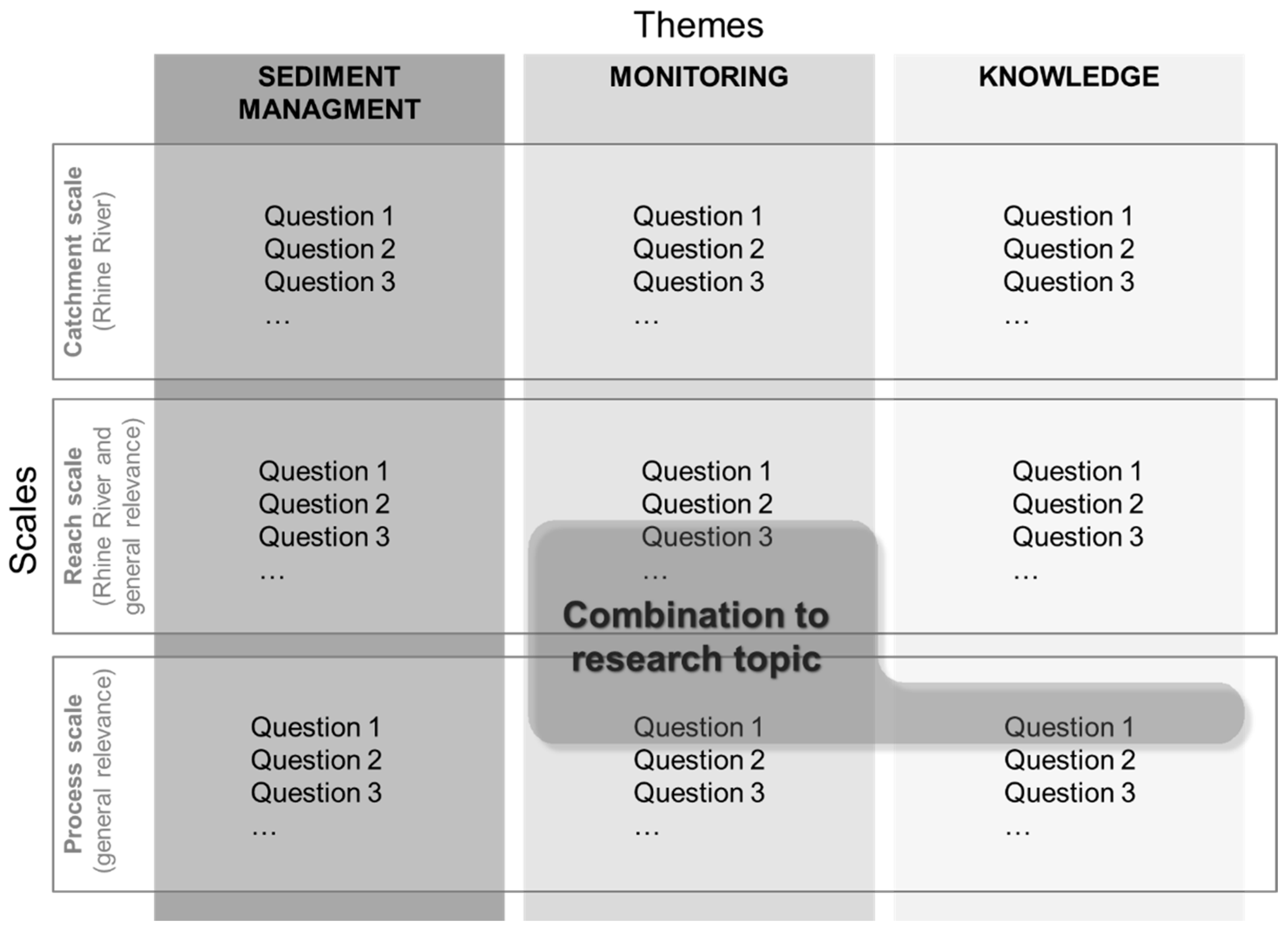
9. Future Research Perspective

During our online talks and based on our literature review, we identified several gaps in respect to sediment management, monitoring, and knowledge. Based on these gaps, on recommendations from Blueland Consultancy [111], on a list compiled by BfG, and on our own considerations, we derived research questions, which affect various scales and themes in the Rhine catchment (Figure 8). With respect to the various scales, some questions address the entire Rhine catchment as one system (the catchment scale) while others target different issues at selected sites (the reach scale) or basic understanding of processes (the process scale). Referring to the different themes, the derived questions either address management practices, monitoring techniques, or general knowledge of sediment-related processes. This approach should ease the development of a research programme by combining individual research questions from different themes and scales to a research topic in order to increase the effectiveness of the research.
The following chapter will present our derived research topics followed by recommendations for future research projects.

9.1. Research Topics

The research topics below are listed in decreasing urgency according to our judgement. For each research topic, we formulated research questions, which should be addressed in follow-up research projects.

9.1.1. Influence of Climate Change and Land Use Change on the Sediment Regime

Climate change will affect river systems in the future even more strongly through changes in precipitation intensities and snow and glacier melt, along with the resulting effects on the hydrograph. Extreme events (either droughts or flood events), which influence sediment transport, will increase in terms of magnitude and frequency. Permafrost thawing will expose more erodible soil, which will raise sediment production in the Alpine catchment while sea level rise will further endanger the delta section. The longer lasting droughts in the summer months will cause limitations for navigation. Land use changes as a reaction to climate change eventually may have consequences on the hydrology and the sediment regime in the Rhine catchment.
The related research questions are:
  • How does climate change affect sediment production in the catchment due to glaciers retreating and permafrost thawing?
  • How does a changed hydrology (discharge regime) due to glaciers melting affect sediment transport, sediment balance, and river functions?
  • In general, which land use changes may be expected due to human interventions, and how will land use adjust to climate change?
  • How does land use change affect sediment production and, consequently, sediment input?
  • How does sea level rise affect bed levels in the lower delta section, and how will this affect upstream reaches?

9.1.2. Impacts of River Engineering (Including Channelization and Continuity Disruptions) on the Entire Rhine’s Morphology and Sediment Budget

The Rhine River has been affected by substantial river engineering in the past, which has narrowed the channel width and straightened the river course, thereby changing sediment transport characteristics. Additionally, the construction of dams for hydropower generation has disrupted sediment continuity, which has provoked a bedload deficit and, consequently, bed erosion in the downstream sections. Anthropogenic interventions have strongly altered the sediment balance and morphology of the Rhine, which in turn have affected various aspects such as flood protection, navigation, hydropower, groundwater, and ecology. The definition of the effects resulting from these anthropogenic interventions would provide an understanding of the present state while knowledge of the undisturbed state of the Rhine River would help to define a more natural state as a target state in relation to restoration measures.
We divided this research topic into the subtopics:
(i)
Channelization effects: This includes a detailed analysis and comparison of the historic conditions of morphology and sediment transport with the present conditions after channelization.
(ii)
Effects from sediment barriers: The permeability of dams depends on various factors such as grain size distribution of sediments supplied from upstream, hydropower plant operation, the characteristics of the reservoir and the weirs. An investigation into the sediment balance prior and after the period of hydropower plant construction would help to identify the impacts of dams on sediment transport.
The related research questions are:
  • How is sediment transport affected by channelization measures?
  • How is the continuity of sediment transport affected by transversal structures?
  • What are the consequences of channelization and damming on the riverbed (erosion/deposition)?
  • How have sediment barriers (e.g., hydropower plants) and channelization affected the sediment yield into downstream reaches and into the sea?
  • What is the transport through Lake Constance?
  • What are the changes in grain size, and how do these changes affect sediment transport?
  • Which sections of the catchment-scale river network show erosion or deposition?
  • Which river sections are currently developing problems/challenges?
  • What did sediment transport and morphology look like before human impacts, and how could this state serve as a target state for re-establishing more natural states in river restoration?
  • How did channelization and damming affect the migration of the gravel–sand transition?
  • How can the catchment-scale evolution of the bed levels be reconstructed in a numerical model?

9.1.3. Impact of Sediment Management Activities on the Overall Sediment Budget of the Rhine River, and Identification of Possibilities for Improvement

The sediment imbalance of the Rhine River [32] is causing problems for (i) various uses such as navigation, hydropower, groundwater use, drinking water supply, etc., (ii) the ecological status (lack of aquatic habitats with favourable sediment characteristics, floodplain disconnection, etc.), and (iii) flood protection (acceleration of flood waves). Sediment management practices are taking place at a reach or local scale but affecting the Rhine River at large scales. For instance, while sediment nourishments target at compensating for the bedload deficit in the eroding reaches, the supplied sediments are also transported downstream. Additionally, the downstream migration of the gravel–sand transition is associated with various causes that need to be disentangled. For that purpose and for a better understanding of the widespread impacts of present management activities, further research is needed. This will help to find solutions to large-scale needs. In terms of the impounded section, follow-up research could look at possibilities to remobilise deposited sediments in the reservoir to compensate for the bedload deficit downstream. Attention must be paid to the eventual contamination of deposited sediments, which means that studies may focus on remobilising only selected areas of harmless sediment.
The related research questions are:
  • What is the interaction between river sections as a result of management practices?
  • Which equilibrium would the current Rhine evolve to, starting from the present state, if maintenance measures were absent?
  • Which equilibrium would the current Rhine evolve to, starting from the present state, if maintenance measures are continued?
  • What is the role of abrasion and sorting in relation to the effect of sediment nourishment?
  • What are the travel paths of nourished sediment?
  • How can sediment nourishments be optimized as a transboundary and essential strategy for future river management?
  • What is the effect of the grain size distribution of the artificially supplied sediments on downstream morphology and sediment transport?
  • How can the permeability of barriers be increased for sediment transport?
  • How can sediment depositions in reservoirs be best remobilised?
  • How can the remobilisation of sediment in reservoirs be concentrated on unpolluted sediment?
  • Which concerted, catchment-scale management concept improves the situation and is most effective by using synergies between individual management actions?

9.1.4. Harmonization of Monitoring Strategies and Consideration of New Monitoring Techniques

Monitoring strategies strongly vary along the riparian countries in the Rhine catchment. This is partly understandable due to the different management needs and characteristics of sediment transport and morphology of the individual river sections. However, it would be wise to harmonize monitoring strategies amongst the riparian countries and increase the continuity of monitoring series in order to make measurement data more comparable and ease catchment-wide interpretation of the data. Also, quality assurance, storage, and data accessibility should be provided catchment-wide for all affected stakeholders. Future monitoring programmes need to fill gaps by exploring new measurement techniques, which would support the development of more intense monitoring activities and measure parameters such as sediment transport (including transport with and on dunes), grain size composition, and sediment porosity. For instance, research should investigate possibilities to exploit remote sensing techniques since they have the advantage of obtaining measurement data on, e.g., sediment transport, grain sizes of bed surfaces, bed levels, and vegetation more rapidly.
The related research questions are:
  • What is the state of the art of the various monitoring techniques that are and can be applied in the Rhine catchment?
  • Which monitoring techniques can be agreed on for application across the whole catchment?
  • What are the best practices in applying monitoring methods?
  • Which new methods are best capable of measuring sediment properties?
  • How can we reliably measure sediment transport on and with bedforms?
  • What are the possibilities of exploiting remote sensing techniques for monitoring purposes?
  • How could a real-time monitoring of morphology be set up, similar to the Rhine alarm monitoring network, to observe water quality?

9.1.5. Optimisation of Sediment Budgeting

Sediment budgeting depends on data availability. So far, the sediment budgeting for the Rhine River was subject to uncertainties and, therefore, requires further investigation. For instance, the lateral sediment exchange with groyne fields or re-connected secondary channels and the eventual deposition into these river sections may also affect the longitudinal transport of sediment. The distribution of suspended sediments at bifurcations is another knowledge gap that requires further attention. Missing information includes the fine sediment exchange with the North Sea and with harbours, as well as the supply from tributaries. Knowledge of travel paths and abrasion would benefit a more accurate sediment budget. Information on sediment porosity is necessary to reliably link volumes to masses of sediment while more knowledge on the grain size distributions of eroded and deposited sediment would further support the budgeting of sediment.
The related research questions are:
  • What is the exchange of sediments between the fairway channel and the groyne fields, how do groyne fields adjust to maintenance measures in the channel, and how does the lateral interaction affect the sediment balance?
  • How is sediment exchanged with harbours?
  • How is sediment exchanged with the North Sea?
  • What is the balance of sediment transport in tidal flow?
  • How is sediment distributed at bifurcations?
  • How can we improve the quantification of diffuse suspended sediment supply?
  • How can we improve the quantification of the supplies from tributaries?
  • How do restoration measures affect the sediment balance?
  • What is the effect of porosity on sediment transport and on the sediment balance?
  • What is the effect of abrasion on sediment transport and on the sediment balance?
  • What is the travel path of individual particles?
  • How can the fractioning of bed level changes (determination of the involved grain sizes) be intensified?
  • How can models be applied to support data-based analyses?

9.1.6. Assessment of the Transfer of Coarse Sediment through the Rhenish Massif

The Rhenish Massif represents a major erosion base, which is characterized by a rocky canyon with locally very large water depths in the bedrock channel. Because bedload transport is limited to a very narrow area of the river cross-section, measurements fail to quantify bedload transport in this river section. Also, common bedload transport formulas cannot be applied here since they are only applicable to rivers with alluvial beds. Nonetheless, knowledge of the sediment transfer through the Rhenish Massif is essential to assess the effects of upstream measures (such as sediment nourishments) on the downstream section.
The related research questions are:
  • How much gravel is transported through the Rhenish Massif?
  • How does bedload transport occur on bedrock and in rock fissures of the Rhenish Massif?
  • How does the sediment transfer occur through the Rhenish Massif?
  • How is the sediment exchanged with sediment stored in the crevices of the bedrock channel?
  • What is the time lag of the transfer resulting from the exchange with stored sediment?

9.1.7. Determination of the Demands of Different Sectors (Hydropower, Navigation, Flood Risk Management, Ecology) on a Sustainable Management of Sediment and Morphodynamics

During our talks with sediment-related experts of the different sectors, we experienced that their demands deviate from each other. For instance, there are conflicting ideas between representatives from navigation and ecology. While the latter emphasizes the need to increase spending efforts on restoration measures to enhance the ecological heterogeneity, navigational demands focus on ensuring fairway requirements. This means that, e.g., excessive river widenings can endanger shipping traffic due to a potentially reduced fairway depth. The demands of the various sectors are different, meaning that measures must be coordinated in an integrative way between all affected stakeholders. In order to define broadly accepted and sustainable management, all demands and possible restrictions from the sectors involved should be included in decision-finding prior to the implementation of measures.
The related research questions are:
  • What are the demands of the hydropower sector regarding sediment management?
  • What are the demands of the inland shipping sector regarding sediment management?
  • What are the demands of the flood risk management sector regarding sediment management?
  • What are the demands of ecology regarding sediment management?
  • Which solutions are positive for all sectors and yield the largest overlap of interests?
  • In respect to the question above, how can the demands and deficits of the individual sectors and stakeholders be compared and harmonized?

9.1.8. Vegetation and Sedimentation

Vegetation is gaining increased importance in combination with increased implementation of restoration measures. During higher discharges, the Rhine may overflow vegetated bars and riverbanks, depositing fine sediments on vegetated floodplains and increasingly disconnect the floodplain from the main channel. In the main channel, vegetated bars can pose obstacles during high flows and increase hydraulic roughness and, thus, decrease the discharge capacity. So far, numerical and laboratory models fail to appropriately describe the transition from suspension to deposition, which happens to be very sensitive to irregular flow conditions on vegetated bars and floodplains. Therefore, the interactions between vegetation growth and sediment deposition need to be addressed by future research. Also, the exact moment in time when the removal of vegetation becomes necessary before flood risk problems may come up is still an open question in parts of the Rhine River.
The related research questions are:
  • Which parameters control the sediment dynamics on vegetated bars and floodplains at the transition from suspension to deposition (and back to remobilisation)?
  • How can numerical and laboratory models reconstruct these processes?
  • What is the monitoring setup needed to measure the sediment dynamics in the floodplain, to establish a data set for model calibration and validation?
  • What are the recommendations regarding maintenance of vegetated channels, based on actual knowledge, to avoid flood risk problems (development of a guideline based on the present state of knowledge for the management of vegetation along the Rhine)?

9.1.9. River Restoration: Bank Erosion and Channel Widening, and Interactions with the Sediment Regime and Sediment Budget

River restoration is increasingly performed in river sections that were subject to engineering measures in the past. By removing bank protection structures and allowing riverbank erosion, both the ecological conditions along the riverbanks and morphodynamics can benefit from channel widening. For the planning of restoration measures, the target state is still an open debate. The estimation of a more natural sediment supply that existed in a historic state is difficult since today’s rivers are in a strongly altered state. Very high natural sediment supply would eventually raise flood risk problems while, at the same time, a minimum amount of sediment is needed to allow the formation of gravel bars and spawning habitats. Moreover, estimating the sediment transport capacity in the restored river reach in advance is difficult. What is further missing are indicators that can be used to monitor the effectiveness of restoration measures. In general, riverbank erosion processes represent a complex combination of different processes, which should be investigated in more detail to improve the ecological conditions more efficiently. Laboratory models to test riverbank erosion are properly applied for river sections in the Alpenrhein where coarse-grained, non-cohesive riverbanks are present. This is difficult to accomplish in the more downstream river sections. There, fine-grained riverbanks with cohesive properties exist, which are difficult to model in the laboratory since gravitational forces can hardly be scaled when obeying laws for the flow and fluvial sediment transport.
The related research questions are:
  • What is the appropriate sediment supply to reach restoration goals?
  • How does riverbank erosion affect the sediment dynamics at the riverbed and the sediment regime?
  • How does riverbank erosion occur at specific sites of the Rhine River, what are the processes involved, how can they be modelled, and what are the interactions between riverbank erosion, bed topography, and sediment transport?
  • What is the effect of riverbank erosion on the sediment budget?
  • What are the initial measures needed to trigger the desired dynamics?
  • What are the measures/boundary conditions needed to ensure sediment conveyance, to avoid flood risk problems?
  • What are the expected bed levels after restoration within the restored section, and up- and downstream?
  • Which indicators may be used to evaluate the effects of measures in land use practices (agricultural use) on the ecological state?
  • How can riverbanks be prepared in a physical laboratory model, so that bank retreat rates and bank geometries are similar to the prototype scale of the Rhine River?

9.2. Ideas for Future Research Projects

The present review paper highlights the need to intensify sediment-related research in the Rhine catchment. Based on the numerous knowledge gaps in terms of sediment management, monitoring, and process understanding in general, we derived several research topics that need to receive further attention in follow-up research activities (see Section 9.1). Since not all of the research topics can be covered immediately, we propose to address the following three research ideas to be realized in order of decreasing priority. We chose them in accordance with their high relevance, which we experienced during the interviews and the literature review.

9.2.1. Influence of Climate Change and Land Use Change on the Sediment Regime

This research idea refers to the research topic described in Section 9.1.1. The project should address the derived research questions at the catchment scale. The desired outcome is a report describing the effects of climate change and land use change on the sediment regime also including figures, maps, and a roadmap for adaptation strategies to improve sediment management at the catchment scale.

9.2.2. Alteration and Improvement of Sediment Balance and Continuity, Sediment Transport, and Morphology (in the Context of the Spatial and Temporal Development of River Engineering and Management in the Rhine River and Major Tributaries)

This research project should study the changes in sediment transport and morphology resulting from past human interventions and management activities and including their spatial and temporal aspects. The related research questions to be addressed are listed in the Section 9.1.2 and Section 9.1.3. Investigations should include processes on a catchment to a regional scale. The desired outcome of this project is a report identifying the main parameters that are responsible for the modification of the river system including their spatio-temporal development. In addition, a guidance document and a manual for sediment management should be elaborated.

9.2.3. Sediment Transport Processes and Management—National and Bilateral Projects

We propose to subdivide this research idea into two project categories:
(i)
Individual studies on sediment processes:
The objective of this project idea is to acquire insights into morphological processes such as abrasion in the context of sediment nourishments, the role of sand transport, the interaction between main channel and groyne fields, and sediment deposition on floodplains. The related research questions are listed in Section 9.1.3, Section 9.1.5, Section 9.1.6, Section 9.1.8 and Section 9.1.9. Expected results include individual insights and novel or improved tools to describe sediment-related processes more accurately.
(ii)
Bilateral projects addressing sediment management
This project category should address sediment management issues in the border sections of Germany and The Netherlands, Germany and France, and Austria, Liechtenstein, and Switzerland. The related research questions are listed in the Section 9.1.3, Section 9.1.4, and Section 9.1.7. Bilateral projects are to be implemented at the regional or reach scale in order to establish or improve a transboundary strategy for an optimized river management. The harmonization of monitoring strategies and measurement techniques among the riparian countries is also of high priority. The expected outcomes of these studies involve possibilities for an improved integrated sediment management in the border regions.

10. Conclusions

The present paper presents a coherent overview of sediment-related issues, research, management, and monitoring activities in the Rhine catchment. The Rhine was heavily modified by human interventions in the past (river engineering, dam construction, etc.) that led to a sediment imbalance and discontinuity of sediment flow, and consequently, to a variety of negative consequences for morphology, ecology, and economy. These interventions included, e.g., channelization measures, which resulted in a strong increase of sediment transport capacities and erosion of the riverbed. Gravel extraction for commercial purposes and the construction of transversal barriers interrupted the river’s continuity, forcing the riverbed level either into a state of aggradation or erosion. In the free-flowing sections, riverbed erosion has become a risk for undermining bridge piers, pipelines, and flood protection structures and is exposing less erodible sediment layers which pose problems for navigation. Due to the decreasing riverbed level, the groundwater level is lowering too, while secondary channels are becoming disconnected from the main channel. Sediment retention behind dams in the Rhine and the tributaries is intensifying the bedload deficit in the free-flowing sections. In the delta section, saltwater intrusion may call for the relocation of existing drinking water abstractions. Currently, plenty of countermeasures are implemented to combat past developments and achieve improvements for all affected sectors. Based on our findings, there are still knowledge gaps, which should be addressed in follow-up research projects in order better understand the morphological processes and, consequently, adapt existing or establish new management and monitoring strategies. From these knowledge gaps, we derived nine research topics, each containing individual research questions. Out of this pool of research topics, we proposed three ideas for research projects that should be implemented with decreasing priority: (i) the influence of climate change and land use change on the sediment regime, (ii) the alteration and improvement of sediment balance and continuity, sediment transport, and morphology (in the context of the spatial and temporal development of river engineering in and management of the Rhine River and major tributaries), and (iii) sediment transport processes and management—national and bilateral projects.

Author Contributions

Conceptualization, M.K. (Michael Krapesch), M.K. (Mario Klösch), W.t.B. and H.H.; methodology, M.K. (Michael Krapesch), M.K. (Mario Klösch), W.t.B. and H.H.; investigation, M.K. (Michael Krapesch), M.K. (Mario Klösch), W.t.B. and H.H.; M.K. (Michael Krapesch), M.K. (Mario Klösch), W.t.B. and H.H.; resources, M.K. (Michael Krapesch), M.K. (Mario Klösch), W.t.B. and H.H.; writing—original draft preparation, M.K. (Michael Krapesch), M.K. (Mario Klösch) and W.t.B.; writing—review and editing, M.K. (Michael Krapesch), M.K. (Mario Klösch), W.t.B. and H.H.; visualization, M.K. (Michael Krapesch), M.K. (Mario Klösch) and W.t.B.; funding acquisition: H.H. and W.t.B. All authors have read and agreed to the published version of the manuscript.

Funding

This research was funded by The International Commission for the Hydrology of the Rhine Basin (CHR) grant number [U2020010].

Data Availability Statement

The data presented in this study are available on request from the corresponding author due to 3rd party data.

Acknowledgments

We would like to thank The International Commission for the Hydrology of the Rhine Basin (CHR) and its member states for funding the research project “Studie zum Forschungsbedarf über den Sedimenthaushalt im Rheineinzugsgebiet”. The project profited from the input of a steering committee, which was established to accompany our investigations. Our sincere thanks go to the steering committee members: Roel Burgers, Benoit Camenen, Roy Frings, Gottfried Gökler, Marc Daniel Heintz, Gudrun Hillebrand, Ralph Schielen, Eric Sprokkereef, and Stefan Vollmer. The present paper benefitted strongly from the input of experts who were interviewed during the project. We would like to thank: Christine Bastian, Astrid Blom, Benoit Camenen, Daniel Dietsche, Roy Frings, Gottfried Gökler, Michael Hengl, Gudrun Hillebrand, Nils Huber, Kai Kempmann, Katinka Koll, Claude Meisch, Manuel Nitsche, Andreas Reiterer, David Schmid, Laurent Schmitt, Ralph Schielen, Matthias Speckle, Pepijn Van Denderen, Stefan Vollmer, Volker Weitbrecht, and Benno Zarn. The financial support by the Christian Doppler Research Association, the Austrian Federal Ministry for Digital and Economic Affairs and the National Foundation for Research, Technology and Development is gratefully acknowledged.

Conflicts of Interest

Author Wilfried ten Brinke was employed by the company Blueland Consultancy. The remaining authors declare that the research was conducted in the absence of any commercial or financial relationships that could be construed as a potential conflict of interest.

References

  1. Habersack, H.; Hauer, C. Reservoir sedimentation—Need for action at global, regional, catchment and local scales. Hydrolink 2019, 4, 114–116. [Google Scholar]
  2. Hauer, C.; Wagner, B.; Aigner, J.; Holzapfel, P.; Flödl, P.; Liedermann, M.; Tritthart, M.; Sindelar, C.; Klösch, M.; Haimann, M.; et al. Das “Christian Doppler Labor für Sedimentforschung und -management”: Anwendungsorientierte Grundlagenforschung und Herausforderungen für eine nachhaltige Wasserkraft und Schifffahrt. Osterr. Wasser Abfallwirtsch. 2019, 71, 137–147. [Google Scholar] [CrossRef]
  3. Klösch, M.; Ten Brinke, W.; Krapesch, M.; Habersack, H. Sediment Management in the Rhine Catchment: Inventory of Knowledge, Research and Monitoring, and an Advice on Future Sediment Research; Report No I-27 of the CHR; International Commission for the Hydrology of the Rhine Basin: Utrecht, The Netherlands, 2021; ISBN 789070980429. [Google Scholar]
  4. Liu, C.; Walling, D.E.; He, Y. Review: The International Sediment Initiative case studies of sediment problems in river basins and their management. Int. J. Sediment Res. 2018, 33, 216–219. [Google Scholar] [CrossRef]
  5. Walling, D.E. The Impact of global change on erosion and sediment transport by rivers: Current progress and future challenges. In UNESCO World Water Assessment Programme; United Nations Educational, Scientific and Cultural Organization: Paris, France, 2009. [Google Scholar]
  6. Habersack, H.; Hein, T.; Stanica, A.; Liska, I.; Mair, R.; Jäger, E.; Hauer, C.; Bradley, C. Challenges of river basin management: Current status of, and prospects for, the River Danube from a river engineering perspective. Sci. Total Environ. 2016, 543, 828–845. [Google Scholar] [CrossRef] [PubMed]
  7. Ten Brinke, W. The Dutch Rhine, a Restrained River; Veen Magazines: Diemen, The Netherlands, 2005. [Google Scholar]
  8. Syvitski, J.P.M.; Kettner, A.J.; Overeem, I.; Hutton, E.W.H.; Hannon, M.T.; Brakenridge, G.R.; Day, J.; Vörösmarty, C.; Saito, Y.; Giosan, L.; et al. Sinking deltas due to human activities. Nat. Geosci. 2009, 2, 681–686. [Google Scholar] [CrossRef]
  9. Quick, I.; König, F.; Baulig, Y.; Schriever, S.; Vollmer, S. Evaluation of depth erosion as a major issue along regulated rivers using the classification tool Valmorph for the case study of the Lower Rhine. Int. J. River Basin Manag. 2019, 18, 191–206. [Google Scholar] [CrossRef]
  10. Mahmood, A.; Han, J.-C.; Ijaz, M.W.; Siyal, A.A.; Ahmad, M.; Yousaf, M. Impact of Sediment Deposition on Flood Carrying Capacity of an Alluvial Channel: A Case Study of the Lower Indus Basin. Water 2022, 14, 3321. [Google Scholar] [CrossRef]
  11. Schleiss, A.J.; Franca, M.J.; Juez, C.; De Cesare, G. Reservoir sedimentation. J. Hydraul. Res. 2016, 54, 595–614. [Google Scholar] [CrossRef]
  12. Scholten, A.; Rothstein, B. Navigation on the Danube—Limitations by Low Water Levels and Their Impacts; Publications Office of the European Union: Luxembourg, 2017. [Google Scholar]
  13. Fedorenkova, A.; Vonk, J.A.; Breure, A.M.; Hendriks, A.J.; Leuven, R.S.E.W. Tolerance of native and non-native fish species to chemical stress: A case study for the River Rhine. Aquat. Invasions 2013, 8, 231–241. [Google Scholar] [CrossRef]
  14. CHR. Strategy 2020–2030; CHR: Utrecht, The Netherlands, 2021. [Google Scholar]
  15. ICPR. Convention on the Protection of the Rhine; ICPR: Bern, Switzerland, 1999. [Google Scholar]
  16. CCNR. Mannheim Declaration “150 Years of the Mannheim Act—The Driving Force Behind Dynamic Rhine and Inland Navigation; CCNR: Strasbourg, France, 2023. [Google Scholar]
  17. Syvitski, J.P.; Vörösmarty, C.J.; Kettner, A.J.; Green, P. Impact of humans on the flux of terrestrial sediment to the global coastal ocean. Science 2005, 308, 376–380. [Google Scholar] [CrossRef]
  18. Wang, H.; Yang, Z.; Saito, Y.; Liu, J.P.; Sun, X.; Wang, Y. Stepwise decreases of the Huanghe (Yellow River) sediment load (1950–2005): Impacts of climate change and human activities. Glob. Planet. Chang. 2007, 57, 331–354. [Google Scholar] [CrossRef]
  19. Habersack, H.; Baranya, S.; Holubova, K.; Vartolomei, F.; Skiba, H.; Schwarz, U.; Krapesch, M.; Gmeiner, P.; Haimann, M. Sediment Manual for Stakeholders, Output 6.2 of the Interreg Danube Transnational Project DanubeSediment; European Commission: Vienna, Austria, 2019. [Google Scholar]
  20. Hohensinner, S.; Hauer, C.; Muhar, S. River morphology, channelization, and habitat restoration. In Riverine Ecosystem Management: Science for Governing towards a Sustainable Future; Springer: Berlin/Heidelberg, Germany, 2018; pp. 41–65. [Google Scholar]
  21. Alexander, J.; Wilson, R.; Green, R. A Brief History and Summary of the Effects of River Engineering and Dams on the Mississippi River System and Delta; US Geological Survey: Reston, VA, USA, 2012. [Google Scholar]
  22. Gore, J.A.; Petts, G.E. Alternatives in Regulated River Management; CRC Press: Boca Raton, FL, USA, 1989. [Google Scholar]
  23. Hohensinner, S.; Jungwirth, M.; Muhar, S.; Schmutz, S. Spatio-temporal habitat dynamics in a changing Danube River landscape. River Res. Appl. 2011, 27, 939–955. [Google Scholar] [CrossRef]
  24. Habersack, H.; Piégay, H. 27 River restoration in the Alps and their surroundings: Past experience and future challenges. Dev. Earth Surf. Process. 2007, 11, 703–735. [Google Scholar]
  25. Lau, J.K.; Lauer, T.E.; Weinmann, M.L. Impacts of channelization on stream habitats and associated fish assemblages in east central Indiana. Am. Midl. Nat. 2006, 156, 319–330. [Google Scholar] [CrossRef]
  26. Chen, X.; Zhou, Q.; Zhang, E. In-channel sand extraction from the mid-lower Yangtze channels and its management: Problems and challenges. J. Environ. Plan. Manag. 2006, 49, 309–320. [Google Scholar]
  27. Wang, Z.; Li, Y.; He, Y. Sediment budget of the Yangtze River. Water Resour. Res. 2007, 43, W04401. [Google Scholar] [CrossRef]
  28. Ashmore, P.; Church, M. The Impact of Climate Change on Rivers and River Processes in Canada; Bulletin of the Geological Survey of Canada: Ottawa, ON, Canada, 2001; pp. 1–48. [Google Scholar]
  29. Ylla Arbós, C.; Blom, A.; Sloff, C.J.; Schielen, R.M.J. Centennial channel response to climate change in an engineered river. Geophys. Res. Lett. 2023, 50, e2023GL103000. [Google Scholar] [CrossRef]
  30. Dunn, F.E.; Darby, S.E.; Nicholls, R.J.; Cohen, S.; Zarfl, C.; Fekete, B.M. Projections of declining fluvial sediment delivery to major deltas worldwide in response to climate change and anthropogenic stress. Environ. Res. Lett. 2019, 84, 084034. [Google Scholar] [CrossRef]
  31. Habersack, H.; Hauer, C. Sedimentforschung und -management. Osterr. Wasser Abfallwirtsch. 2019, 71, 108–110. [Google Scholar] [CrossRef]
  32. Frings, R.M.; Hillebrand, G.; Gehres, N.; Banhold, K.; Schriever, S.; Hoffmann, T. From source to mouth: Basin-scale morphodynamics of the Rhine River. Earth-Sci. Rev. 2019, 196, 102830. [Google Scholar] [CrossRef]
  33. Frings, R.M.; Döring, R.; Beckhausen, C.; Schüttrumpf, H.; Vollmer, S. Fluvial sediment budget of a modern, restrained river: The lower reach of the Rhine in Germany. Catena 2014, 122, 91–102. [Google Scholar] [CrossRef]
  34. Frings, R.M.; Gehres, N.; Promny, M.; Middelkoop, H.; Schüttrumpf, H.; Vollmer, S. Today’s sediment budget of the Rhine River channel, focusing on the Upper Rhine Graben and Rhenish Massif. Geomorphology 2014, 204, 573–587. [Google Scholar] [CrossRef]
  35. Van der Perk, M.; Vilches, A.E. Compositional dynamics of suspended sediment in the Rhine River: Sources and controls. J. Soils Sediments 2020, 20, 1754–1770. [Google Scholar] [CrossRef]
  36. Cox, J.R.; Dunn, F.E.; Nienhuis, J.H.; Van der Perk, M.; Kleinhans, M.G. Climate change and human influences on sediment fluxes and the sediment budget of an urban delta: The example of the lower Rhine–Meuse delta distributary network. Anthr. Coasts 2021, 4, 251–280. [Google Scholar] [CrossRef]
  37. International Commission for the Protection of the Rhine. Rhine 2040 and working plan 2022–2027. In Proceedings of the Presentation at the 87th CHR Meeting, Online, 26 October 2021. [Google Scholar]
  38. Uehlinger, U.; Arndt, H.; Wantzen, K.M.; Leuven, R.S.E.W. The Rhine River Basin. In Rivers of Europe; Elsevier: Amsterdam, The Netherlands, 2009; pp. 199–245. [Google Scholar]
  39. Hillebrand, G.; Frings, R. Von der Quelle zur Mündung: Die Sedimentbilanz des Rheins im Zeitraum 1991–2010; Report No II-22 of the CHR; CHR: Utrecht, The Netherlands, 2017. [Google Scholar] [CrossRef]
  40. Rösch, N. Die Rheinbegradigung durch Johann Gottfried Tulla; ZfV-Zeitschrift für Geodäsie, Geoinformation und Landmanagement: Zürich, Switzerland, 2009. [Google Scholar]
  41. Arnaud, F.; Schmitt, L.; Johnstone, K.; Rollet, A.-J.; Piégay, H. Engineering impacts on the Upper Rhine channel and floodplain over two centuries. Geomorphology 2019, 330, 13–27. [Google Scholar] [CrossRef]
  42. Van de Ven, G.P. Verdeel en Beheers! 300 Jaar Pannerdensch Kanaal; Veen Magazines: Diemen, The Netherlands, 2007. [Google Scholar]
  43. Ten Brinke, W. Land in Sea. The Water History of the Netherlands; Veen Magazines: Diemen, The Netherlands, 2007. [Google Scholar]
  44. Diaz-Redondo, M.; Egger, G.; Marchamalo, M.; Damm, C.; de Oliveira, R.P.; Schmitt, L. Targeting lateral connectivity and morphodynamics in a large river-floodplain system: The upper Rhine River. River Res. Appl. 2018, 34, 734–744. [Google Scholar] [CrossRef]
  45. Middelkoop, H.; Erkens, G.; Van der Perk, M. The Rhine delta—A record of sediment trapping over time scales from millennia to decades. J. Soils Sediments 2010, 10, 628–639. [Google Scholar] [CrossRef]
  46. Middelkoop, H. Embanked Floodplains in the Netherlands. Geomorphological Evolution over Various Time Scales. Ph.D. Thesis, Universiteit Utrecht, Utrecht, The Netherlands, 1997. [Google Scholar]
  47. Van der Perk, M.; Sutari, C.A.T.; Middelkoop, H. Examination of the declining trend in suspended sediment loads in the Rhine River in the period 1952–2016. In Book of Abstracts NCR Days 2019; Utrecht University: Utrecht, The Netherlands, 2019. [Google Scholar]
  48. Görgen, K.; Beersma, J.; Buiteveld, H.; Brahmer, G.; Carambia, M.; Keizer, O.D.; Krahe, P.; Nilson, E.; Lammersen, R.; Perrin, C.; et al. Assessment of Climate Change Impacts on Discharge in the River Rhine Basin. Results of the RheinBlick2050 Project; Rapport I-23 2010; The International Commission for the Hydrology of the Rhine basin (CHR): Utrecht, The Netherlands, 2010. [Google Scholar]
  49. Bergmeister, U.; Kalt, L. Der Alpenrhein und Seine Regulierung, Rheinregulierung, I., Ed.; BuchsDruck und Verlag: Buchs, Switzerland, 1992.
  50. Zarn, B.; Oplatka, M.; Pellandini, S.; Mikos, M.; Hunziker, R.; Jäggi, M. Geschiebehaushalt Alpenrhein; Mitteilungen der Versuchsanstalt für Wasserbau, Hydrologie und Glaziologie: Zürich, Switzerland, 1995. [Google Scholar]
  51. Zarn, B. Entwicklungskonzept Alpenrhein. Osterr. Wasser Abfallwirtsch. 2008, 60, 81–87. [Google Scholar] [CrossRef]
  52. Dietsche, D.; Internationale Rheinregulierung (IRR), Rheinbauleiter Schweiz, St. Margrethen, Switzerland. Personal communication, 2021.
  53. Gökler, G.; Illwerke VKW AG, Vorarlberg, Austria. Personal communication, 2021.
  54. Zarn, B. Morphology and Floods in the Alpine Region. In Proceedings of the KHR/CHR Meeting “From the Source to Mouth, a sediment budget of the Rhine River”, Lyon, France, 25–26 March 2015. [Google Scholar]
  55. Zarn, B.; Hunziker, Zarn & Partner AG, Aarau, Switzerland. Personal communication, 2021.
  56. Schmid, D.; Canton Graubünden, Ministry of Nature and Environment, Department Surface Waters, Chur, Switzerland. Personal communication, 2021.
  57. Speckle, M.; Internationale Rheinregulierung (IRR), Rheinbauleiter Österreich, St. Margrethen, Switzerland. Personal communication, 2021.
  58. Internarionale Rheinregulierung. Wir Sind Hochwasserschutz. 2022. Available online: https://rhesi.org/media/pages/service/publikationen/a2f81fc56d-1687790462/irr_imagebroschuere_2022_web.pdf (accessed on 12 February 2024).
  59. Internationale Regierungskommission Alpenrhein; Internarionale Rheinregulierung. Entwicklungskonzept Alpenrhein; Kurzbericht: Sils im Domleschg, Switzerland, 2005. [Google Scholar]
  60. Kolb, R.; Herzog, B. Aufweitung Alpenrhein Maienfeld/Bad Ragaz; Technischer Bericht zum Bau- und Auflageprojekt: Widnau, Switzerland, 2023. [Google Scholar]
  61. Weitbrecht, V.; ETH Zürich, Laboratory of Hydraulics, Hydrology and Glaciology, Zürich, Switzerland. Personal communication, 2021.
  62. Nitsche, M.; Federal Office for the Environment (BAFU), Water Division, Hydropower Rehabilitation Section, Bern, Switzerland. Personal communication, 2021.
  63. Reiterer, A.; Federal Institution of the Republic of Austria, Austrian Service for Torrent and Avalanche Control (die.wildbach), Provincial Headquarters Vorarlberg, Vorarlberg, Austria. Personal communication, 2021.
  64. Hunziker, R. Fraktionsweiser Geschiebetransport. Mitteilungen der Versuchsanstalt für Wasserbau, Hydrologie und Glaziologie; ETH Zürich: Zürich, Switzerland, 1995. [Google Scholar]
  65. Schilling, M.; Hunziker, R. Programm MORMO (MORphologisches MO-dell). Mathematische Modelle offener Gerinne. In Proceedings of the ÖWAV-Seminar, Wien, Austria, 27–28 February 1995. [Google Scholar]
  66. Hunziker, Z.P.A. Morphologie und Geschiebehaushalt Alpenrhein; Zusammenfassender Bericht über die Untersuchungen zwischen 1985 und 2000; Hunziker, Zarn & Partner AG: Domat/Ems, Switzerland, 2001. [Google Scholar]
  67. Hunziker, Z.P.A. Einfluss von Vegetation auf Kiesbänken auf den Hochwasserspiegel im Alpenrhein; Technischer Bericht; Tiefbauamt St. Gallen: St. Gallen, Switzerland, 2018. [Google Scholar]
  68. Federal Office for the Environment. Monitoring Networks for Sediment Transport in Bodies of Water. 2019. Available online: https://www.bafu.admin.ch/bafu/en/home/topics/water/state/water--monitoring-networks/monitoring-networks-for-sediment-transport-in-bodies-of-water.html (accessed on 9 November 2023).
  69. Buck, W.; Felkel, K.; Gerhard, H.; Kalweit, H.; Malde, J.v.; Nippes, K.-R.; Ploeger, B.; Schmitz, W. Der Rhein unter der Einwirkung des Menschen. Ausbau, Schiffahrt, Wasserwirttschaft; Bericht I-11. Lelystad; International Commission for the Hydrology of the Rhine Basin: Utrecht, The Netherlands, 1993. [Google Scholar]
  70. CCNR. Inland Navigation in Europe, Market Observation; Central Commission for the Navigation of the Rhine: Strasbourg, France, 2023. [Google Scholar]
  71. Arnaud, F.; Piégay, H.; Schmitt, L.; Rollet, A.; Béal, D. Using historical and experimental geomorphology for restoring rivers: Insights from the Old Rhine. In Proceedings of the SHF Conference “Small Scale Morphological Evolution of Coastal, Estuarine and River Systems”, Nantes, France, 6–7 October 2014. [Google Scholar]
  72. Gölz, E. Die Herkunft des Rheingeschiebes—Ein Geologisch-Petrografischer Beitrag zum Geschiebeproblem; Bundesanstalt für Gewässerkunde: Koblenz, Germany, 1980. [Google Scholar]
  73. Gölz, E. Der Einfluss des Geschiebeabriebs auf die Sohlenerosion des Oberrheins; Bundesanstalt für Gewässerkunde: Koblenz, Germany, 1984. [Google Scholar]
  74. Schmitt, L.; Morris, D.; Kondolf, G.M. Managing Floods in Large River Basins in Europe: The Rhine River. In Managing Flood Risk; Springer International Publishing: Cham, Switzerland, 2018; p. 759. [Google Scholar]
  75. Commission Permanente. Démonstration de L’efficacité des Mesures de Rétention des Crues du Rhin Supérieur entre Bâle et Worms; Rapport intermédiaire; Commission Permanente: Koblenz, Germany, 2016. [Google Scholar]
  76. Abegg, J.; Kirchhofer, A.; Rutschmann, P. Masterplan Maßnahmen zur Geschiebereaktivierung im Hochrhein. Bundesamt für Energie BFE, Bern/Regierungspräsidium Freiburg. 2013. Available online: www.news.admin.ch/NSBSubscriber/message/attachments/29940.pdf (accessed on 15 February 2024).
  77. Bernet, D.; Burger, S.; Dürrenmatt, R.; Harder, U.; Vollenweider, S. Interkantonale Planung Aare. In Koordinationsbericht zur strategischen Planung nach Gewässerschutzgesetz der Kantone Aargau; Kanton Aargau, Abteilung Landschaft und Gewässer/Abteilung Wald; Kanton Bern, Amt für Landwirtschaft und Natur/Amt für Wasser und Abfall; Kanton Solothurn, Amt für Umwelt/Amt für Wald, Jagd und Fischerei: Bern, Switzerland, 2014. [Google Scholar]
  78. Hillebrand, G.; The German Federal Institute of Hydrology (BfG), Department M3—Fluvial Morphology, Sediment Dynamics and Management, Koblenz, Germany. Personal communication, 2021.
  79. Huber, N.; Federal Waterways Engineering and Research Institute (BAW), Department of River Engineering, Hydraulic Engineering in Inland Areas, Karlsruhe, Germany. Personal communication, 2021.
  80. Chardon, V.; Schmitt, L.; Piégay, H.; Beisel, J.-N.; Staentzel, C.; Barillier, A.; Clutier, A. Effects of Transverse Groynes on Meso-Habitat Suitability for Native Fish Species on a Regulated By-Passed Large River: A Case Study along the Rhine River. Water 2020, 12, 987. [Google Scholar] [CrossRef]
  81. Arnaud, F.; Piégay, H.; Béal, D.; Collery, P.; Vaudor, L.; Rollet, A.-J. Monitoring gravel augmentation in a large regulated river and implications for process-based restoration. Earth Surf. Process. Landf. 2017, 42, 2147–2166. [Google Scholar] [CrossRef]
  82. Schmitt, L.; Beisel, J.-N.; Preusser, F.; de Jong, C.; Wantzen, K.; Chardon, V.; Staentzel, C.; Eschbach, D.; Damm, C.; Rixhon, G.; et al. Sustainable Management of the Upper Rhine River and Its Alluvial Plain: Lessons from Interdisciplinary Research in France and Germany; KIT: Karlsruhe, Germany, 2019; p. 345. [Google Scholar]
  83. Agence de l’eau Rhin Meuse. Plan Rhin Vivant. 2019. Available online: https://www.eau-rhin-meuse.fr/actualites/plan-rhin-vivant (accessed on 20 February 2024).
  84. Eschbach, D.; Piasny, G.; Schmitt, L.; Pfister, L.; Grussenmeyer, P.; Koehl, M.; Skupinski, G.; Serradj, A. Thermal-infrared remote sensing of surface water–groundwater exchanges in a restored anastomosing channel (Upper Rhine River, France). Hydrol. Process. 2017, 31, 1113–1124. [Google Scholar] [CrossRef]
  85. Eschbach, D.; Schmitt, L.; Imfeld, G.; May, J.-H.; Payraudeau, S.; Preusser, F.; Trauerstein, M.; Skupinski, G. Long-term temporal trajectories to enhance restoration efficiency and sustainability on large rivers: An interdisciplinary study. Hydrol. Earth Syst. Sci. 2018, 22, 2717–2737. [Google Scholar] [CrossRef]
  86. Jeannot, B.; Weill, S.; Eschbach, D.; Schmitt, L.; Delay, F. A low-dimensional integrated subsurface hydrological model coupled with 2-D overland flow: Application to a restored fluvial hydrosystem (Upper Rhine River—France). J. Hydrol. 2018, 563, 495–509. [Google Scholar] [CrossRef]
  87. Jeannot, B.; Weill, S.; Eschbach, D.; Schmitt, L.; Delay, F. Assessing the effect of flood restoration on surface–subsurface interactions in Rohrschollen Island (Upper Rhine river—France) using integrated hydrological modeling and thermal infrared imaging. Hydrol. Earth Syst. Sci. 2019, 23, 239–254. [Google Scholar] [CrossRef]
  88. Schmitt, L.; University of Strasbourg, Vice President of Sustainable Development and Corporate Responsibility, Strasbourg, France. Personal communication, 2021.
  89. Chardon, V.; Schmitt, L.; Piégay, H.; Lague, D. Use of terrestrial photosieving and airborne topographic LiDAR to assess bed grain size in large rivers: A study on the Rhine River. Earth Surf. Process. Landf. 2020, 45, 2314–2330. [Google Scholar] [CrossRef]
  90. Chardon, V.; Schmitt, L.; Arnaud, F.; Piégay, H.; Clutier, A. Efficiency and sustainability of gravel augmentation to restore large regulated rivers: Insights from three experiments on the Rhine River (France/Germany). Geomorphology 2021, 380, 107639. [Google Scholar] [CrossRef]
  91. Garnier, A.; Barillier, A. The Kembs project: Environmental integration of a large existing hydropower scheme. Houille Blanche 2015, 21–28. [Google Scholar] [CrossRef]
  92. Staentzel, C.; Arnaud, F.; Combroux, I.; Schmitt, L.; Trémolières, M.; Grac, C.; Piégay, H.; Barillier, A.; Chardon, V.; Beisel, J.N. How do instream flow increase and gravel augmentation impact biological communities in large rivers: A case study on the Upper Rhine River. River Res. Appl. 2018, 34, 153–164. [Google Scholar] [CrossRef]
  93. Staentzel, C.; Combroux, I.; Barillier, A.; Grac, C.; Chanez, E.; Beisel, J.-N. Effects of a river restoration project along the Old Rhine River (France-Germany): Response of macroinvertebrate communities. Ecol. Eng. 2019, 127C, 114–124. [Google Scholar] [CrossRef]
  94. Staentzel, C.; Combroux, I.; Barillier, A.; Beisel, J.-N. L’étude temporelle des transitions paysagères et de l’hétérogénéité dans la mosaïque d’habitats comme outil d’évaluation des opérations de restauration écologique? Retours d’expériences et analyse comparative. Tech. Sci. Méthodes 2020, 15–29. [Google Scholar] [CrossRef]
  95. Koll, K.; Dittrich, A.; Koll, K. Interreg IVa—Investigation of External Bed-Load Transport over Static Armour Layers in Laboratory Experiments; Report-No 1013; Leichtweiß-Institut für Wasserbau, Technische Universität Braunschweig: Braunschweig, Germany, 2011. [Google Scholar]
  96. Nardi, L.; Koll, K.; Dittrich, A. Interreg IVa—Assessment of Morphodynamic Changes at Kapellengrien and Pilot Site O3 by 3D Numerical Modelling; Report-No 1018; Leichtweiß-Institut für Wasserbau, Technische Universität Braunschweig: Braunschweig, Germany, 2012. [Google Scholar]
  97. Piégay, H.; Béal, D.; Blum, C.; Maier, M.; Aelbrecht, D.; Arnaud, F.; Barillier, A.; Durand, P.; Abderrazzak, K.; Dittrich, A.; et al. Redynamisierung des Restrheins. Tome 1. Machbachkeitsuntersuchung. In Programm Interreg IV Oberrhein Redynamisierung des Restrheins; Abschlussbericht 2009–2012; Strasbourg, France, 2012. [Google Scholar]
  98. Chardon, V.; Schmitt, L.; Piégay, H.; Arnaud, F.; Serouilou, J.; Houssier, J.; Clutier, A.; Rivière, N. Geomorphic effects of gravel augmentation on the Old Rhine River downstream from the Kembs dam (France, Germany). In Proceedings of the E3S Web of Conferences, Lyon-Villeurbanne, France, 5–8 September 2018; Volume 40. [Google Scholar] [CrossRef]
  99. Arnaud, F.; Staentzel, C.; Beisel, J.-N.; Piégay, H.; Grac, C.; Trémolieres, M.; Combroux, I.; Schmitt, L.; Barillier, A.; Garnier, A. Geomorphic and ecological monitoring of an experimental sediment reintroduction into the Rhine River downstream of the Kembs dam Bilan éco-morphologique de la recharge sédimentaire expérimentale sur le Vieux Rhin. In Proceedings of the 2nd International Conference IS Rivers, Lyon, France, 22–26 June 2015. [Google Scholar]
  100. International Commission for the Protection of the Rhine. Internationale Flussgebietseinheit Rhein: Merkmale, Überprüfung der Umweltauswirkungen menschlicher Tätigkeiten und wirtschaftliche Analyse der Wassernutzung; Internationale Kommission zum Schutz des Rheins: Koblenz, Germany, 2005. [Google Scholar]
  101. International Commission for the Protection of the Rhine. Der Rhein unter der Einwirkung des Menschen—Ausbau, Schifffahrt; Internationale Kommission zum Schutz des Rheins: Koblenz, Germany, 1993. [Google Scholar]
  102. Vollmer, S.; The German Federal Institute of Hydrology (BfG), Head of Department M3—Fluvial Morphology, Sediment Dynamics and Management, Koblenz, Germany. Personal communication, 2021.
  103. Kempmann, K.; Central Commission for the Navigation of the Rhine (CCNR), Administrator, Strasbourg, France. Personal communication, 2021.
  104. Federal Ministry for Digital and Transport. KLIWAS Auswirkungen des Klimawandels auf Wasserstraßen und Schifffahrt in Deutschland. Abschlussbericht des BMVI. Fachliche Schlussfolgerungen aus den Ergebnissen des Forschungsprogramms KLIWAS; Bundesministerium für Verkehr und Digitale Infrastruktu: Berlin, Germany, 2015. [Google Scholar]
  105. Federal Ministry for Digital and Transport. Das BMVI-Expertennetzwerk “Wissen—Können—Handeln”. Synthesebericht zur Forschungsphase 2016–2019; Federal Ministry for Digital and Transport: Berlin, Germany, 2020. [Google Scholar]
  106. Federal Ministry for Digital and Transport. DAS-Basisdienst “Klima und Wasser” Anpassung an den Klimawandel: Robuste Entscheidungen durch Qualitätsgesicherte Daten; Federal Ministry for Digital and Transport: Berlin, Germany, 2019. [Google Scholar]
  107. Bastian, C.; Ministry of Environment, Climate and Sustainable Development Luxembourg, Water Management and Administration, Department of Hydrology, Luxembourg. Personal communication, 2021.
  108. Meisch, C.; Ministry of Environment, Climate and Sustainable Development Luxembourg, Water Management and Administration, Department of Hydrology, Luxembourg. Personal communication, 2021.
  109. Ylla Arbós, C.; Blom, A.; Viparelli, E.; Reneerkens, M.; Frings, R.M.; Schielen, R.M.J. River Response to Anthropogenic Modification: Channel Steepening and Gravel Front Fading in an Incising River. Geophys. Res. Lett. 2021, 48, e2020GL091338. [Google Scholar] [CrossRef]
  110. Bundesanstalt für Gewässerkunde (Hg.). Kompendium Forschung und Entwicklung 2020/2021; Bundesanstalt für Gewässerkunde: Koblenz, Germany, 2020. [Google Scholar] [CrossRef]
  111. Blueland Consultancy. Sediment Management in the Rhine Catchment: Research Inventory for the Dutch Rhine and an Advice at the Catchment Scale; Report B19.02; Blueland Consultancy: Utrecht, The Netherlands, 2019. [Google Scholar]
  112. Van Eijsbergen, E.; Schielen, R.M.J. Long-term development of lowland rivers, Rivers2Morrow—A research program. In Proceedings of the NCR DAYS 2023 Proceedings, Nijmegen, The Netherlands, 12–13 April 2023. [Google Scholar]
  113. Bundesanstalt für Gewässerkunde. BfG Sediment Datenbank. 2023. Available online: https://geoportal.bafg.de/d-seddbp/SeddbServlet (accessed on 12 February 2024).
  114. Asselman, N.E.M.; Buiteveld, H.; Haasnoot, M.; Kwaad, F.J.P.M.; Kwadijk, J.C.J.; Middelkoop, H.; van Deursen, W.P.A.; van Dijk, P.M.; Vermuist, J.A.P.H.; Wesselin, C. The Impact of Climate Change on the River Rhine and the Implications for Water Management in the Netherlands; Summary Report of the NRP Project 952210; RIZA Report 2000.010/ICG-Report 00/04; Rijkswaterstaat: Utrecht, The Netherlands, 2000. [Google Scholar]
  115. Netherlands Centre for River Studies. Rivers2Morrow. 2023. Available online: www.rivers2morrow.nl (accessed on 18 February 2024).
  116. Blom, A.; Technical University of Delft, Delft, The Netherlands. Personal communication, 2021.
  117. Van Denderen, R.P.; Paarlberg, A.; Augustijn, D.C.M.; Schielen, R.M.J. Insight into the local bed-level dynamics to assist management of multi-functional rivers. In NCR Days 2021; The University of Twente: Twente, The Netherlands, 2021. [Google Scholar]
  118. Van Vuren, S.; Paarlberg, A.; Havinga, H. The aftermath of “Room for the River” and restoration works: Coping with excessive maintenance dredging. J. Hydro-Environ. Res. 2015, 9, 172–186. [Google Scholar] [CrossRef]
  119. Royal HaskoningDHV. Grip on Side Channels (Text in Dutch); Royal HaskoningDHV: Amsterdam, The Netherlands, 2019. [Google Scholar]
  120. Deltares. Information Requirements and Recommendations for Monitoring in the UPPER Delta of the Dutch Rhine (Text in Dutch); NKWK-Pilot 2016—A2. Rapport Deltares 11200356-000; Deltares: Delft, The Netherlands, 2017. [Google Scholar]
  121. Blueland Consultancy. Effects Morphological Developments on Functions Rhine and Meuse (Effecten Morfologische Ontwikkelingen op Functions Rijn en Maas) (Text in Dutch); Report B19.01; Blueland Consultancy: Utrecht, The Netherlands, 2019. [Google Scholar]
  122. Erkens, G. Sediment dynamics in the Rhine catchment. In Quantification of Fluvial Response to Climate Change and Human Impact; Utrecht University: Utrecht, The Netherlands, 2009. [Google Scholar]
  123. Schielen, R.M.J.; Rijkswaterstaat—Ministry of Infrastructure and Water Management, Lelystad, The Netherlands. Personal communication, 2021.
  124. Lokin, L.R.; Warmink, J.J.; Bomers, A.; Hulscher, S.J.M.H. River dune dynamics during low flows. Geophys. Res. Lett. 2022, 49, e2021GL097127. [Google Scholar] [CrossRef]
  125. Van denderen, R.P.; University of Twente, Faculty of Engineering Technology, Twente, The Netherlands. Personal communication, 2021.
  126. Britannica. Delta Works. 2022. Available online: https://www.britannica.com/event/Delta-Works (accessed on 13 October 2023).
  127. Verdict Media Limited. Delta Works Flood Protection, Rhine-Meuse-Scheldt Delta. 2023. Available online: https://www.water-technology.net/projects/delta-works-flood-netherlands/ (accessed on 13 October 2023).
  128. Rijkswaterstaat. The Story of the Outlet of Rhine-Meuse (Het Verhaal van de Rijn-Maasmonding); Rijkswaterstaat: Utrecht, The Netherlands, 2019. [Google Scholar]
  129. Sennema, H.; Van de Laar, P. Rotterdam’s New Waterway: The Iconification of an Infrastructure (1860–1947). Eur. J. Creat. Pract. Cities Landsc. 2021, 4, 77–94. [Google Scholar]
  130. Blom, A. Bed Degradation in the Rhine River. Delta Links. 2016. Available online: http://flowsplatform.nl/#/bed-degradation-in-the-rhine-river-1479821439344 (accessed on 15 February 2024).
  131. Huismans, Y.; Koopmans, H.; Wiersma, A.; de Haas, T.; Berends, K.; Sloff, K.; Stouthamer, E. Lithological control on scour hole formation in the Rhine-Meuse Estuary. Geomorphology 2021, 385, 107720. [Google Scholar] [CrossRef]
  132. Ylla Arbós, C.; Blom, A.; Van Vuren, S.; Schielen, R.M.J. Bed Level Change in the Upper Rhine Delta Since 1926 and Rough Extrapolation to 2050; Delft University of Technology: Delft, The Netherlands, 2019. [Google Scholar]
  133. Cox, J.R.; Huismans, Y.; Knaake, S.M.; Leuven, J.R.F.W.; Vellinga, N.E.; van der Vegt, M.; Hoitink, A.J.F.; Kleinhans, M.G. Anthropogenic Effects on the Contemporary Sediment Budget of the Lower Rhine-Meuse Delta Channel Network. Earth’s Future 2021, 9, e2020EF001869. [Google Scholar] [CrossRef]
  134. Pierik, H.J.; Stouthamer, E.; Cohen, K.M. Natural levee evolution in the Rhine-Meuse delta, the Netherlands, during the first millennium CE. Geomorphology 2017, 295, 215–234. [Google Scholar] [CrossRef]
  135. Niesten, I. Morphodynamics of Estuarine Channels with Mixtures of Sand, Silt and Clay. 2022. Available online: https://kbase.ncr-web.org/rivers2morrow/projects/morphodynamics-of-estuarine-channels-with-mixtures-of-sand-silt-and-clay (accessed on 9 November 2023).
Figure 1. (a) The Rhine River located in central Europe. (b) The Rhine catchment (shaded grey) and distinctions between the five morphological sections (separated by dashed lines): Alpine section, impounded section, free-flowing section, lower delta section, and upper delta section. White arrow: flow direction of the Rhine River (Sources: European Commission, Eurostat, GISCO, Esri, USGS, NOAA).
Water 16 01121 g001
Figure 2. Longitudinal profile of the Rhine River indicating the five morphological sections, the three base levels (Lake Constance, the Rhenish Massif, and the North Sea) and the five main tributaries the Aare, Neckar, Main, Mosel, and Maas (modified after Ten Brinke [7]).
Water 16 01121 g002
Figure 3. The Alpenrhein at Landquart (Alpenrhein km 23.5) in 1850 (Dufour map) and today (marked in blue) (modified after [54]).
Water 16 01121 g003
Figure 4. The impounded section (rkm 24–334) including all 21 hydropower plants (Source: Esri, Maxar, Earthstar Geographics, and the GIS user community).
Water 16 01121 g004
Figure 5. The Rhine River system between Neuburg (rkm 355) and Sondernheim (rkm 380) indicating river channelization in 1817 (Source: Generallandesarchiv Karlsruhe, H Rheinstrom 72, http://www.landesarchiv-bw.de/plink/?f=4-1736483-1, accessed on 26 February 2024).
Water 16 01121 g005
Figure 6. Riverbed erosion of the Bovenrijn (rkm 855–865) and the Waal (rkm 865–955) with the indicated bathymetrical surveys in 1950 (dark blue dashed line), 1960 (blue dashed line), 1969 (light-blue dashed line), 1980 (dark-green dashed line), 1990 (light-green dashed line), 1999 single-beam (orange dashed line), 1999 multibeam (orange solid line), 2009 (red solid line), and 2018 (black solid line). Riverbed surveys from 1950 to 1999 and from 1999 to 2018 are single-beam and multibeam, respectively (Source: Data Rijkswaterstaat).
Water 16 01121 g006
Figure 7. Bed level trends between 2002 and 2012 with identified scour holes (a). Scour hole growth over five years in respect to depth (b) and extent (c). Bar plot of scour hole development between 2009 and 2014 in the southern (Merwedes, Bergsche Maas, Amer, Haringvliet, Hollandsch Diep), connecting (Spui, Oude Maas, Dordtsche Kil, and Noord), and northern branches (Maasmond, Nieuwe Waterweg, Nieuwe Maas, Hollandsche IJssel, and Lek) (d) [131].
Water 16 01121 g007
Figure 8. Arrangement of research questions according to the addressed themes and scales, and the combination of research questions on a research topic.
Water 16 01121 g008
Disclaimer/Publisher’s Note: The statements, opinions and data contained in all publications are solely those of the individual author(s) and contributor(s) and not of MDPI and/or the editor(s). MDPI and/or the editor(s) disclaim responsibility for any injury to people or property resulting from any ideas, methods, instructions or products referred to in the content.

