1. Introduction
In recent years, climate change and the rapid urbanization of cities have caused significant urban flooding resulting in traffic disturbances, the disruption of services, damage to properties and critical infrastructure, harm to vulnerable populations, and sometimes the loss of lives [
1,
2,
3]. An important contribution to threats posed by floods is the generation of flood maps and the estimation of flood risk [
4]. Generally, “risk” is defined as the potential consequences of a hazard and flood maps indicate the inundated areas based on the rising water levels, although flood maps alone are not adequate to assess risks to property, infrastructure, and services due to flood events. Therefore, socio-economic factors are critical for a flood risk assessment [
5]. The United Nations International Strategy for Disaster Reduction (UNISDR) [
6] defined a risk assessment as a process or application of a methodology for evaluating risk as defined by the geographic coverage of the hazard, the exposure of people, property, and infrastructure to the hazard, and the vulnerability of people, property, and infrastructure to the event. A flood risk assessment is a systematic procedure to identify, analyze, and quantify the real and expected damage threats of flooding [
7].
A flood hazard is a potentially damaging phenomenon which may cause loss of life or injury, property damage, social and economic disruption, and environmental degradation [
8]. Flood hazards have increased in recent years due to climate change, fast socio-economic development, population growth, and the inefficient use of land. An urban flood hazard assessment is important for the mitigation of floods and a necessary step for government policies on urban planning worldwide [
4]. They help the planners manage better the sites for urban development and recognize areas that probably need stormwater runoff infrastructure [
8]. Flood hazards have increased in recent years because of different factors, such as climate change, subsidence, fast socio-economic development, population growth, the inefficient use of land, and urbanization, resulting in an increased amount of impervious surfaces [
9,
10]. Generally, flood hazard assessment and mapping are used to identify areas at risk of flooding, and, consequently, to improve flood risk management. The assessments and maps typically look at the expected extent and depth of flooding corresponding to various return periods [
11]. In the context of Kano city, Temitope [
12] generated a unit hydrograph for the River Jakara in Kano metropolis using rainfall data. Abaje et al. [
13] investigated the changing rainfall pattern in Kano over a period of 6 decades. Mohammed et al. [
14] examined rainfall dynamics and climate change in Kano using 100 years of rainfall data and Mohammed et al. [
15] examined the gaps between climate change and urbanization in Kano city.
According to the Intergovernmental Panel on Climate Change [
16], vulnerability is defined as “the degree to which a system is susceptible to, and unable to cope with, adverse effects of climate change, including climate variability and extremes”. Vulnerability determines how people will be affected and where they are spatially located [
17]. Vulnerability is a multi-faceted concept with varying characteristics or dimensions in nature. It is a set of multiple stressors that act together to determine the vulnerability of an area. These stressors include the geographical location, the exposure of the population and infrastructure, the socio-economic and cultural conditions, the political and institutional structures, and the coping and adaptive capacity that differentiate the impacts on people and the human system [
18]. This also means that an area may be highly exposed to a hazard such as a flood, but be less vulnerable if it has adequate means to adapt to the flood. Vulnerability is therefore not only a matter of exposure, but rather a combination of exposure with local socio-economic factors [
18]. Flanagan et al. [
19] argued that social vulnerability refers to the socio-economic and demographic factors that affect the resilience of communities. Social vulnerability can have multiple forms: it can be the state of the system before the event, the likelihood of outcomes in terms of economic losses and life lost, and the lack of capacities or weaknesses to face and recover quickly when the disaster strikes. A better understanding of the level of vulnerability and how the susceptible population is distributed can be beneficial for the better management of flood risk [
20]. There are numerous studies that have considered the vulnerabilities of social, economic, and environmental systems to flooding [
21,
22,
23,
24,
25]. Action Aid [
26] investigated the vulnerability of six African cities on the basis of key management criteria including local people’s perceptions of the causes of flooding, adaptation, and the community’s social coping capacity. Nabegu [
24] assessed the vulnerability of households in the study area to a flood disaster, using a questionnaire survey, infrastructure analysis and flood impact information. Social vulnerability refers to the characteristics of a person or group in terms of their capacity to anticipate, cope with, resist, and recover from the impact of a natural hazard [
27]. Social vulnerability is related to gender, class, race, age, poverty, and many more factors [
28]. In this study, social vulnerability was considered because the study area was an urban center with a significant population and valuable assets.
There are a number of multi-criteria evaluation concepts that are being used in assessing social vulnerability such as the Analytical Hierarchy Process [
29,
30] and the method for the improvement of vulnerability in Europe (MOVE) framework [
18]. In the MOVE framework, a characterization of vulnerability is performed through three key factors, namely, (1) exposure, (2) susceptibility, and (3) lack of resilience [
18]. The MOVE framework was developed as a vulnerability assessment framework, arising from the MOVE project carried out from 2008 to 2011 in Europe. It was developed based on past vulnerability projects in Europe, but the concept is used worldwide [
27]. The advantages of the MOVE framework is that it can be applied to assess vulnerability not only to floods, but other natural disasters such as droughts, extreme temperature, earthquakes, etc. It can be used to analyze physical, social, economic, social, environmental, cultural, and institutional vulnerabilities at different geographical scales. Lianxiao and Morimoto [
27] used the MOVE framework and the Information Entropy Method to carry out a spatial analysis of social vulnerability to floods in Katsushika Ward, Tokyo, Japan. Williams and Muhammad [
31] applied the MOVE framework with ArcGIS 10.2 to assess social vulnerability to malaria in Katsina-Ala, Benue State, Nigeria. Kablan et al. [
18] used the MOVE framework to assess social vulnerability to floods in urban Côte d’Ivoire and Sane et al. [
32] applied the MOVE framework to assess social vulnerability to floods in Medina Gounass Dakar, Senegal. Even though the MOVE framework was developed in Europe [
33,
34], it is applied worldwide including in Pakistan [
35], Japan [
27], and Africa [
18,
32]. The MOVE framework was also used by researchers to assess the level of vulnerability due to climate change impacts [
36,
37].
Other approaches, such as machine learning, have been used by researchers in urban flood risk assessments. Choubin et al. [
38] used model averaging, classification and regression trees, and support vector machine to develop a machine learning model that can be used for flood hazard assessment based on return periods. Variables used as the input include precipitation, elevation, distance from stream, slope, land use, flow accumulation, drainage density, topographic wetness index, soil order, normalized difference vegetation index, flow accumulation, aspect, curvature, and lithology. Sentinel 1 Radar images were used to identify flooded images with different return periods for model validation. The results showed that the models performed very well, with an accuracy greater than 90%. Taromideh et al. [
39] integrated the multi-criteria decision-making technique of the analytic hierarchy process and machine learning techniques of classification and regression models to develop an urban flood risk map. The results showed that the urban flood hazard was mostly influenced by drainage density, and the distance to the river and to vulnerable areas. Likewise, urban flood vulnerability was mostly influenced by land use, dwelling quality, population density, household income, and the distance to hospitals and cultural heritage centers. The flood risk map classified the areas into five categories, going from very low to very high flood risk areas. Many researchers have integrated either decision-making approaches with machine learning or big data analytic techniques in conjunction with GIS to model the flood hazard and/or vulnerability [
40,
41,
42,
43,
44,
45,
46].
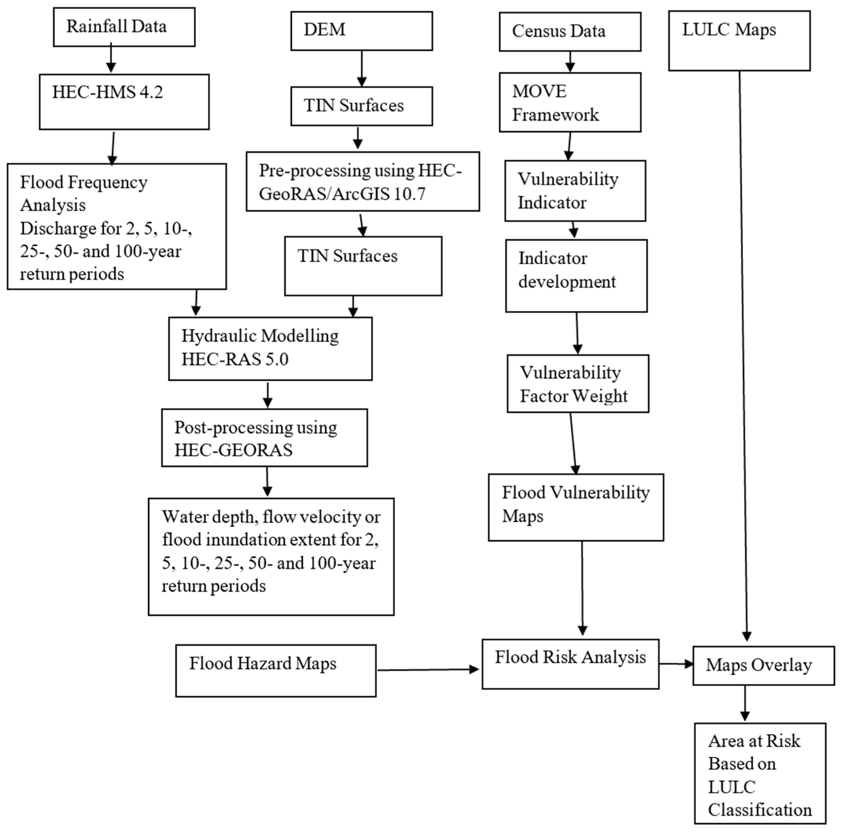
No study known to the researchers has integrated a frequency-based flood hazard assessment with the multi-criteria evaluation method of the MOVE framework. The lack of such a study on flood hazard estimation for the whole city makes it difficult to determine the possible areas that are prone to flooding with a view to propose mitigation measures. The present study is the first to use flood frequency analysis to estimate the flood hazard and then integrate the flood hazard with flood vulnerability assessments to determine the flood risk in a densely populated sub-Saharan African city.
4. Discussion
Flooding has been a major source of concern arising from the huge economic losses encountered. The type of flood in Kano is pluvial and usually occurs annually during the rainy season, affecting mainly the urban areas in Nigeria. Such floods, which are arguably unprecedented in recent times, are caused by more frequent and severe rainfall which overwhelms the capacity of drainage systems. Nkwunonwo [
23] reported that flooding occurs annually during the rainy season between July and October, ravaging many cities in Nigeria. Presently, the occurrence of such floods due to poor urban planning is an important issue in flood risk mitigation. The pluvial flooding occurs when rainfall–runoff, which ought to be evacuated by the drainage system, remains on impermeable surfaces and flows overland or into local depressions and topographically low areas to create temporary ponds. It mostly occurs after a short, intense downpour which cannot be evacuated quickly enough by the drainage system or seep into the ground [
56]. Built environments generate higher surface runoff, in excess of the local drainage capacity, thereby causing local floods [
10,
57]. Intense urbanization, rapid conversion of green spaces to residential and commercial areas, and neglect to town-planning and landscape conservation have resulted in the emergence of urban slums in the city, which has further aggravated the flood risk [
58].
Climate change impacts are also known to have a severe impact on the urban drainage system. Climate change increases the intensity of rainfall events posing a major threat to stormwater infrastructure systems [
59]. Higher rainfall intensities lead to more severe storms, with expected increases in damage to urban centers. Pluvial flooding has been predicted to become more frequent due to climate change and urbanization [
60]. Kano city is extremely overcrowded, which constantly threatens the city’s infrastructural management systems. Due to the population size, the sewage and waste water management system is overburdened, the drainage network system is inadequate, and there are cases of dumping of household and commercial refuse in open landfills and direct discharges to the streams and drains. The integration of urban growth and climate change scenarios into flood risk management models as proposed by researchers [
61,
62] could go a long way in addressing flood issues in developing countries. In the absence of climate change prediction models, flood hazard mapping using flood frequency estimates coupled with flood vulnerability can serve as viable tools to address flood problems in developing countries. However, it is worth noting that the flood plain areas studied are urban catchments which have long been inhabited with densely populated settlements. There is no agency, whether governmental or non-governmental, that keeps a record of floods during the storm events in the basins. Therefore, no field data were available to validate the flood hazard results with observed data, as the two catchments are ungauged.
5. Conclusions
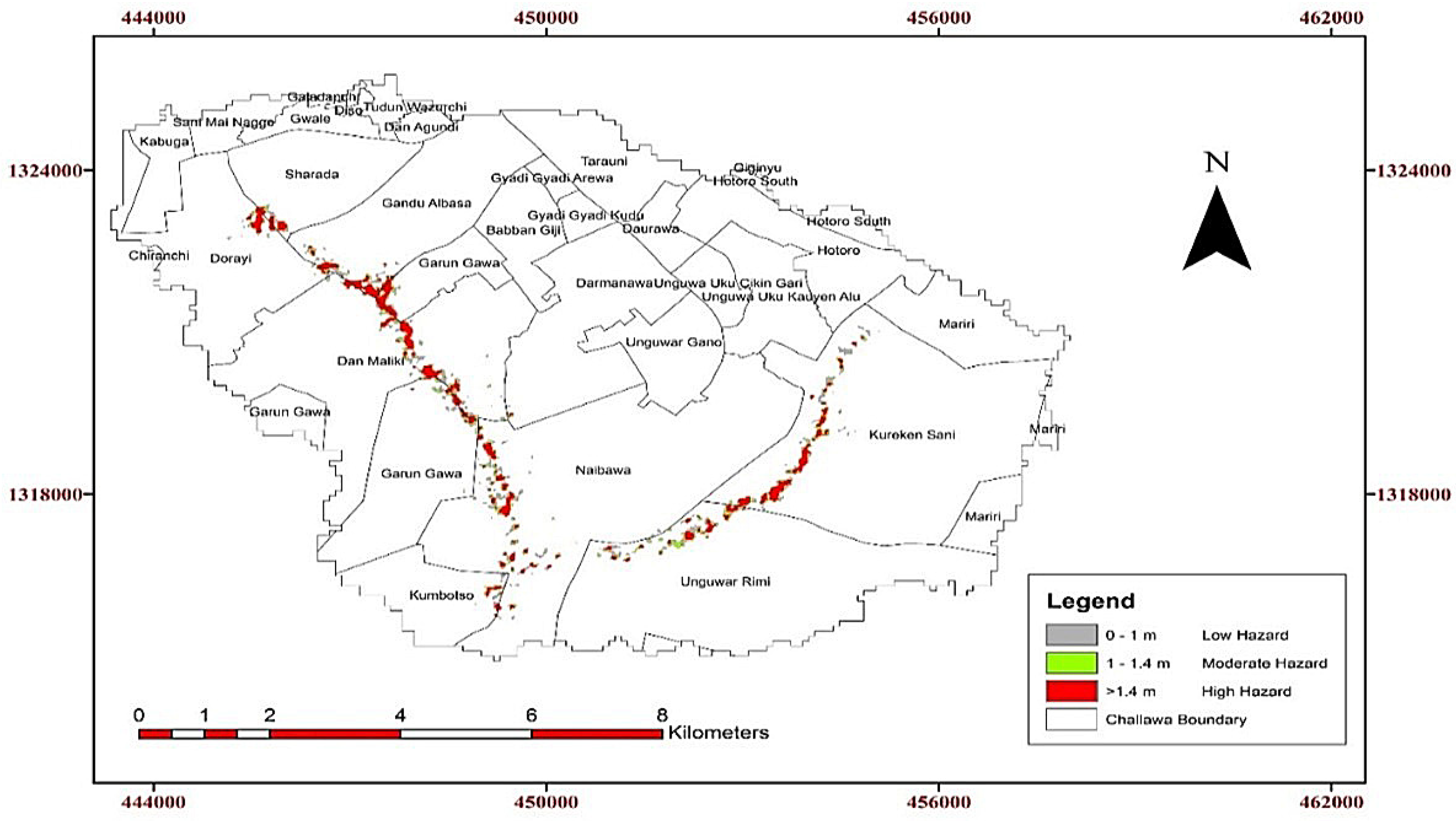
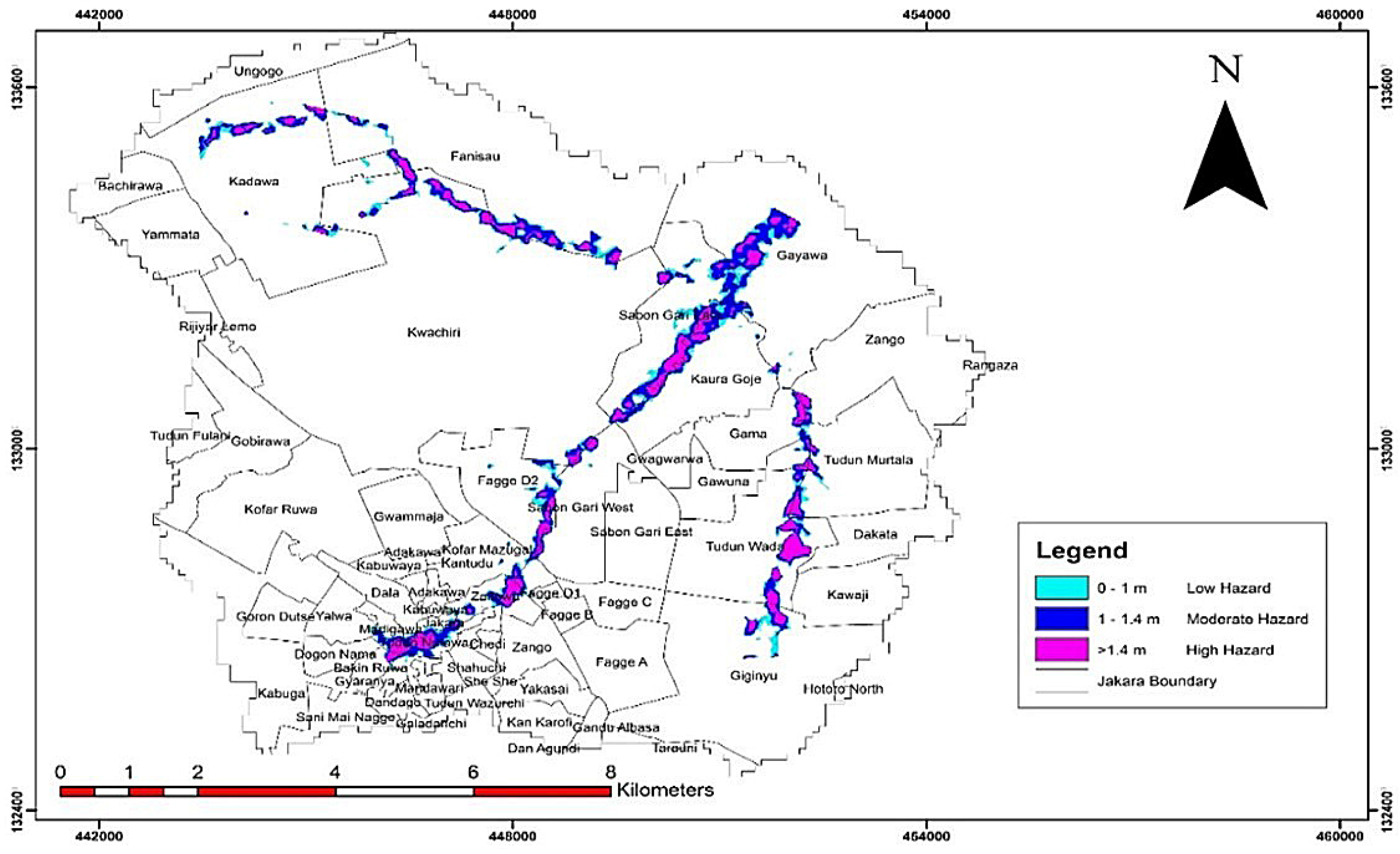
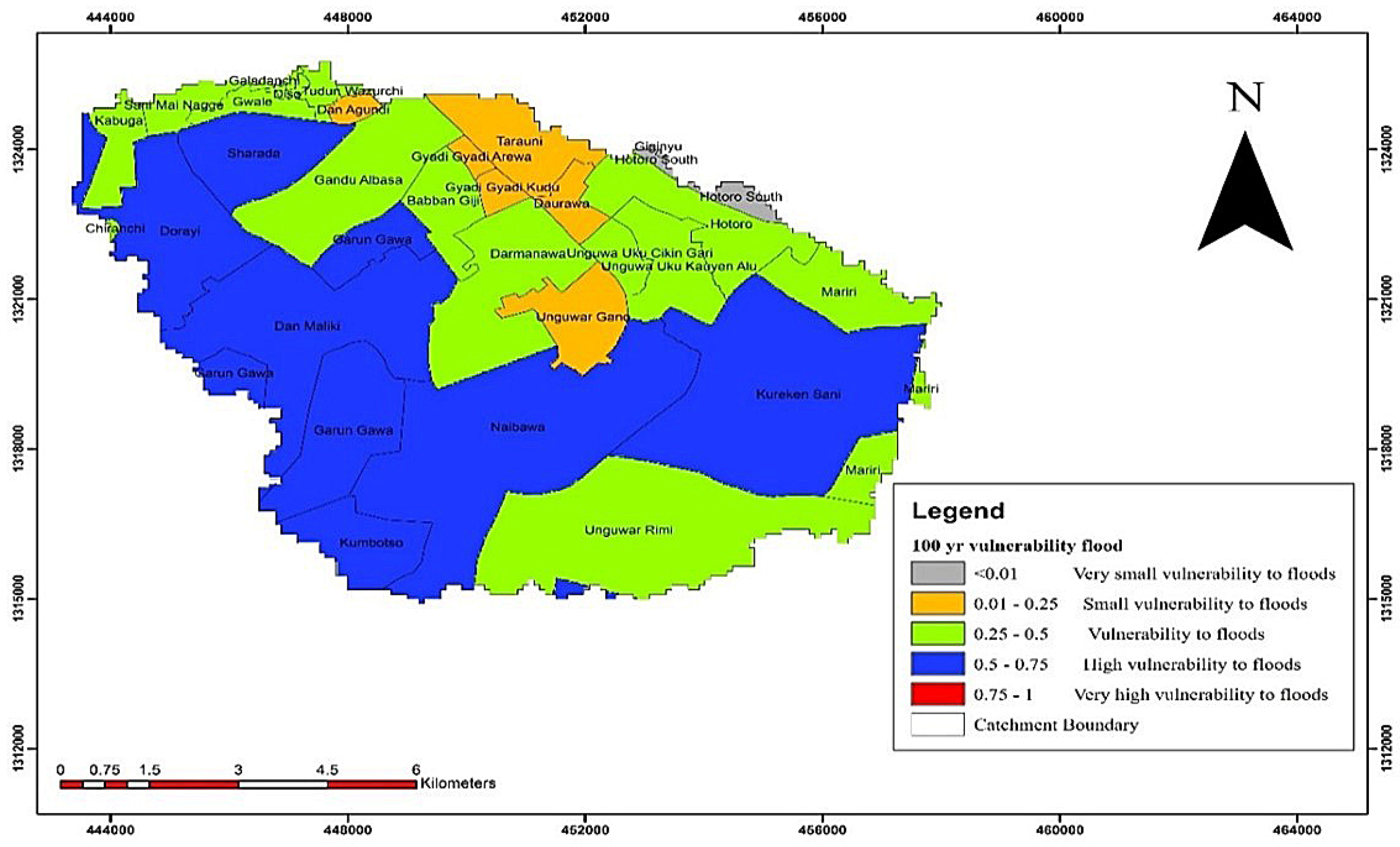
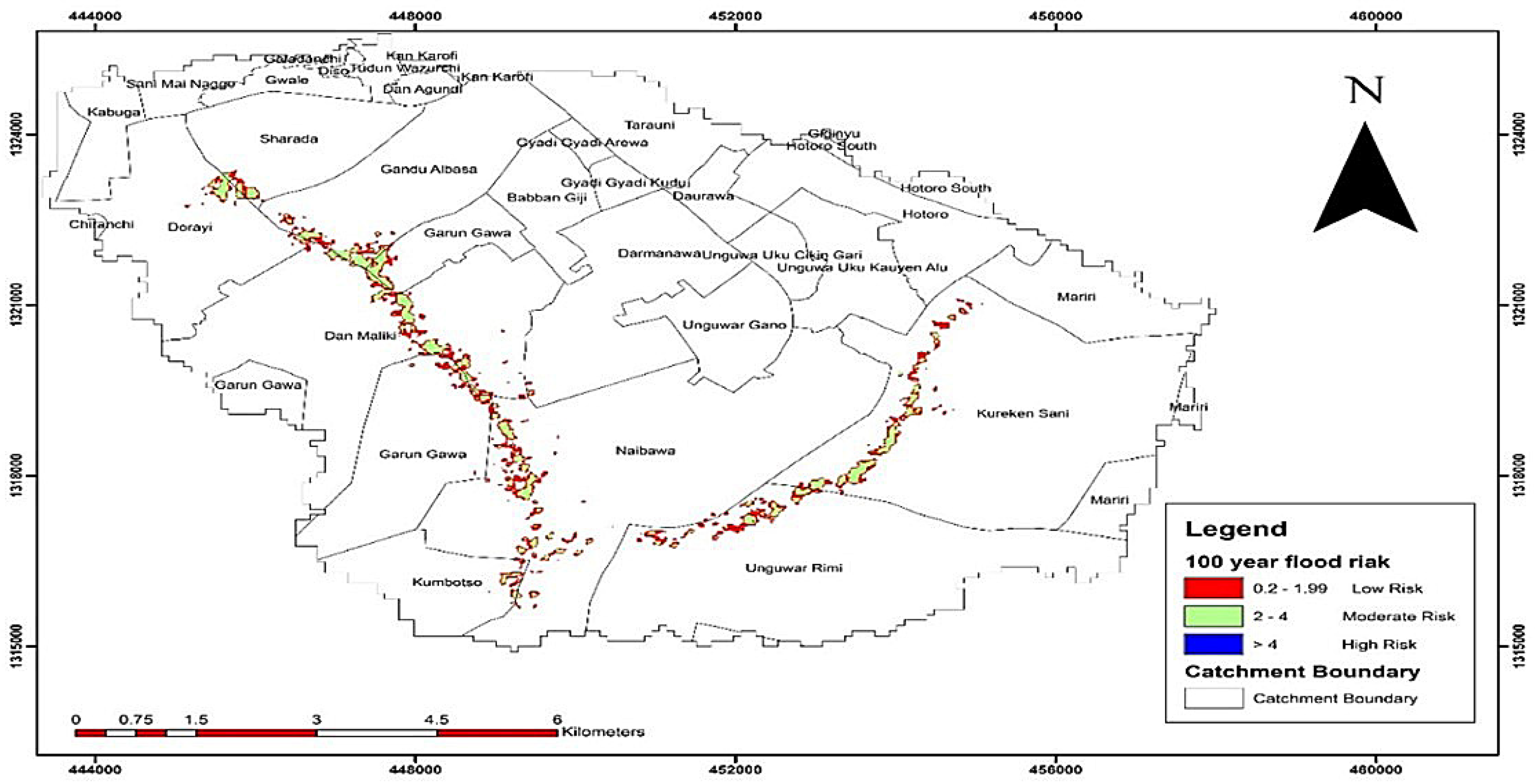
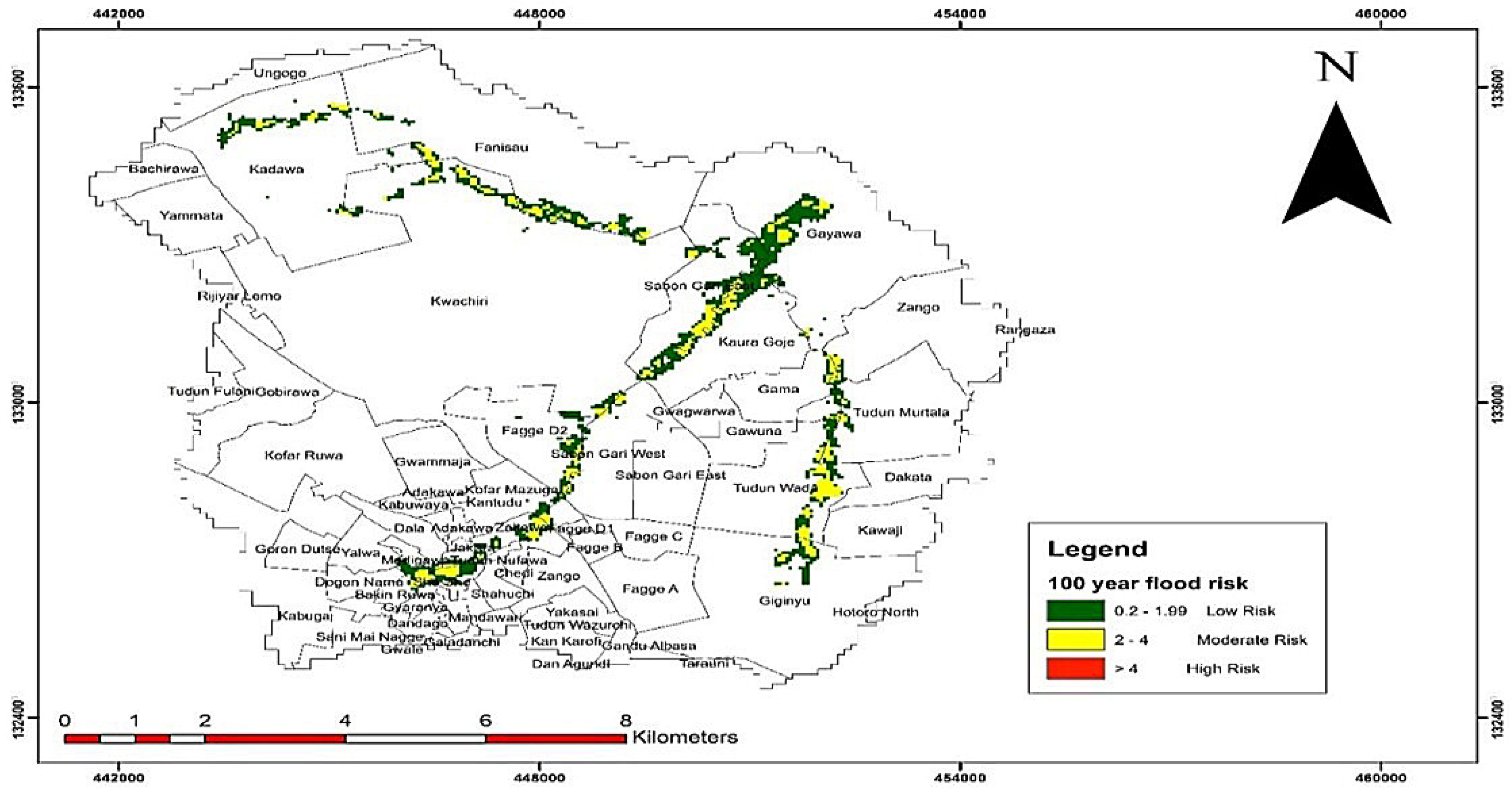
A flood frequency analysis for 2, 5, 10, 25, 50, and 100-year return periods was carried out using the Log Pearson Type III distribution and flood hazard and inundation mappings for Challawa and Jakara basins of Kano metropolis were developed. For the 100-year return period flood, a total area of 12.13 km2 would be inundated for Challawa basin while a total area of 17.36 km2 would be inundated for Jakara basin. Generally, for both catchment areas, it can be concluded that most of the flood hazard areas fall within the category of low and medium hazards, but high hazard areas were also located along the channels, and districts that are prone to flooding were identified. Social vulnerability was assessed and the districts that fell within the categories of VSVF, SVF, HVF, MVF, and SVF were identified and classified for return periods of 2 to 100-year floods. A total area of 50.91 and 40.56 km2 was found to be affected by the different categories of vulnerabilities for the 100-year flood, but there was no VHVF zone for all the return periods considered. A flood risk map for the two basins was developed, and 10.50 km2 of land was affected by the risk of a 100-year flood, of which 4.98 km2 is built-up area in Challawa basin. For Jakara basin, 14.23 km2 of land area was affected, of which 6.50 km2 is a built-up area. As the city is densely populated, with a population density of well over 20,000 persons per square kilometer in the highly built-up locations, this means that much more than 230,000 persons will be affected by flood risk in the two basins.
