Abstract
Deepwater regions have emerged as pivotal domains for global oil and gas exploration and development, serving as strategic alternatives to conventional resources. The Silk Road region is distinguished by its abundant oil and gas reserves and stands as a leading arena for worldwide exploration and development in the oil and gas sector. Since 2012, a series of atmospheric fields have been discovered in the deep sea of the Luwuma Basin and the Tanzania Basin, with cumulative recoverable reserves reaching 4.4 × 10¹² and 8.3 × 10¹¹ m3, including multiple oil and gas fields ranking among the top ten global discoveries at that time. Profound advancements have been achieved in the exploration of deepwater oil and gas reserves along the Silk Road. However, deepwater oil and gas exploration presents challenges, such as high development costs and risks, leading to certain areas remaining underexplored and exhibiting a relatively low level of exploration activity, thereby hinting at considerable untapped potential. Deepwater sedimentary basins along the Silk Road predominantly adhere to a distribution pattern characterized as “one horizontal and one vertical”. The “horizontal” dimension refers to the deepwater basin grouping within the Neo-Tethys tectonic domain, primarily extending from east to west. Conversely, the “vertical” dimension denotes the deepwater basin grouping along the East African continental margin, predominantly extending from north to south. Recent discoveries of deepwater oil and gas reserves validate the presence of foundational elements within Silk Road basins conducive to the formation of substantial oil and gas reservoirs and the establishment of efficient migration pathways. Despite these achievements, exploration activities in deepwater oil and gas resources along the Silk Road remain relatively limited. Future exploration endeavors in deepwater regions will predominantly focus on identifying structural and lithological traps. In the deepwater areas of the Bay of Bengal, the emphasis is on lithological traps formed by Neogene turbidite sandstone deposits. In the deepwater regions of Pakistan, the focus shifts to lithological traps emerging from Neogene bio-reefs and river-channel sandstone accumulations. Along the deepwater coastline of East Africa, the focus is on lithological traps formed by nearshore Mesozoic–Cenozoic bio-reefs and seafloor turbidite sandstone formations. Within the deepwater regions of Southeast Asia, the primary objective is to locate large structural-type oil and gas fields. Analyzing the characteristics of oil and gas discoveries in deepwater areas aims to enhance the theory of the control of the formation of deepwater oil and gas, providing valuable insights for predicting future exploration directions.
1. Introduction
Currently, the global landscape of oil and gas exploration and development is marked by an escalating trend in reserves and production. The focal point of this exploration has progressively shifted toward deep sea, deep strata, and unconventional aspects [1,2,3,4,5,6]. The initiation of deepwater oil and gas exploration dates back to the late 1970s, and as of now, global deepwater regions are in the early stages of exploration, harboring significant potential and opportunities for the discovery of giant oil and gas fields. Advances in offshore geophysical exploration and deep-sea drilling technologies [7] have facilitated the shift from shallow waters to deep and ultradeep waters in global offshore oil and gas exploration. This transition has resulted in a surge of deepwater oil and gas discoveries, with more than half of the significant findings occurring in these deepwater areas [8]. There is a forecast that up to 40% of future oil and gas reserves may be located in deep-sea regions [9]. Based on exploration experiences, it is estimated that global offshore areas contain over 120 billion tons of undiscovered oil and gas resources, with a substantial portion situated in deepwater regions [3]. Given these abundant resources and decreasing development costs, deepwater oil and gas exploration has emerged as a central focus for global oil and gas exploration, representing a pivotal domain for future development [10,11]. At present, the deepwater basins that harbor significant oil and gas resources are primarily located in the East African region, South China Sea, northwestern Australian continental shelf, Gulf of Mexico, eastern Brazilian continental margin, western African continental margin, and central Norwegian continental shelf. These regions are predominantly situated along passive continental margins, forming an overall distribution pattern of “three vertical and two horizontal” [12,13,14,15].
Global deepwater oil and gas resources are abundant, establishing a new frontier that supports the future development of international oil companies. As oil and gas exploration technology advances and exploration activities persist, the volume of deepwater oil and gas resources has grown rapidly, positioning it as a significant player in the global energy market [9,16]. In the past decade, newly discovered offshore oil and gas reserves have accounted for 60% of the global total, with the deepwater to ultra-deepwater sector contributing 61.99% of these discoveries [17]. The regions along the Maritime Silk Road, hereinafter referred to as the Silk Road, harbor numerous deepwater basins, making it a global hotspot for oil and gas exploration. It is also a primary focus for China’s offshore oil and gas exploration and development cooperation, fostering collaboration on energy resources with relevant countries. This is of utmost importance for ensuring national energy security and advancing the vision of the “21st Century Maritime Silk Road”.
Deepwater basins along the Silk Road are primarily situated in the Neotethyan Basin and the East African continental margin. These areas are characterized by numerous basins, diverse types, and multiple structural and sedimentary epochs, providing favorable conditions for oil and gas reservoirs with significant resource potential. To date, 54 deepwater oil and gas discoveries have been confirmed, with gas-dominated fields being prevalent. The reservoirs primarily consist of deepwater turbidite sandstones and deltaic–littoral sandstones. Previous studies in this region have predominantly concentrated on individual basin oil and gas geology, regional structural–sedimentary evolution, basin geological structures, the distribution and prediction of source rocks, oil and gas potential, and exploration directions. There has been limited systematic geological analysis from a regional deepwater oil and gas accumulation perspective [18,19,20,21].
Furthermore, the current challenges faced by deepwater oil and gas exploration, such as high development costs and significant exploration and development risks, underscore the importance of studying the distribution characteristics and exploration patterns of deepwater oil and gas. Leveraging data from oil and gas field databases such as IHS Markit and Wood Mackenzie [22,23], alongside recent data on oil and gas exploration discoveries and evaluations, this study conducts a comprehensive analysis of petroleum geological conditions in various regions along the Silk Road. It explores source rocks, reservoirs, and cap rocks; investigates distribution patterns of deepwater oil and gas; summarizes reservoir characteristics; examines the controlling factors behind major oil and gas field formation in deepwater basins; and outlines future directions for deepwater oil and gas exploration. This endeavor provides valuable insights for the advancement of cooperative oil and gas exploration along the Maritime Silk Road.
2. Geological Background
The Silk Road mainly includes the Indian Ocean coast and Southeast Asia, involving the Asia Pacific, East Africa, and other regions, with numerous sedimentary basins developed. The prevailing structural configuration of the Silk Road basins is attributed to the fragmentation of the Gondwana supercontinent, commencing during the Jurassic period. This process originated from the collision of the Eurasian Plate, the Indo-Australian Plate, and the Pacific Plate. This geological evolution involved intricate phenomena, including complex faulting, separation events, the effusion of basaltic lavas, and collision occurrences [24,25]. These processes collectively resulted in the formation of complex structural patterns. The geological record of this region is replete with consequential tectonic episodes, such as supercontinent breakup, seafloor spreading, and collision-related orogeny, leading to diverse plate boundaries encompassing divergent, convergent, and transform margins. Consequently, this region stands out as one of the most tectonically active areas globally [26,27,28].
The primary tectonic framework of this region primarily comprises landmasses that have undergone a series of geologic events, including rifting, collision, and amalgamation across different geological epochs. This prolonged process of landmass amalgamation facilitated complex structural and sedimentary transformations, ultimately leading to the formation of sedimentary strata of varying ages overlying crystalline basement rocks. As a consequence, the region hosts a diverse range of sedimentary basins spanning from the Paleozoic to the Cenozoic (Figure 1). Notably, the Mesozoic and Cenozoic periods represent the principal epochs during which these basins formed, housing significant oil and gas resources along the Silk Road.
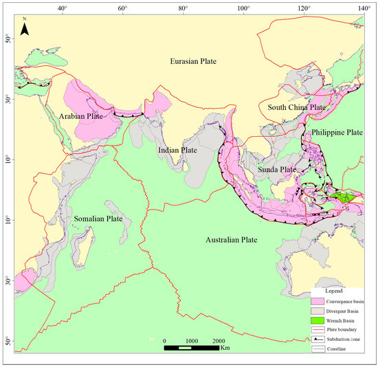
Figure 1.
Simplified map of the coastal and peripheral continental structures along the Silk Road.
On the fringes of the Silk Road, passive continental margin basins are predominantly distributed along the eastern coastline of Africa, as well as the eastern and western coasts of India. Back-arc basins are primarily situated to the northeast of the Sunda-Java subduction zone, arising from the subduction of the Indo-Australian Plate beneath the Eurasian Plate. Forearc basins are most notably found to the southwest of Sumatra Island.
3. Characteristics of Hydrocarbon Resources along the Silk Road
3.1. Characteristics of Oil and Gas Resource Distribution along the Silk Road
The countries and regions spanning the Silk Road possess expansive territories abundant in marine mineral resources, with a pronounced emphasis on oil and gas. This area stands out not only as one of the world’s foremost reservoirs of oil and gas but also as one of the most dynamic hubs for exploration and development on a global scale. The exploration status in oil- and gas-bearing basins within the Silk Road maritime zones indicates that the Bay of Bengal, the Neotethyan deepwater basin group, the Arabian Sea deepwater basin, the East African continental margin deepwater basin group, and certain segments of the deepwater basins in the Western Pacific exhibit relatively low exploration levels, resulting in fewer discoveries of oil and gas fields (Figure 2).
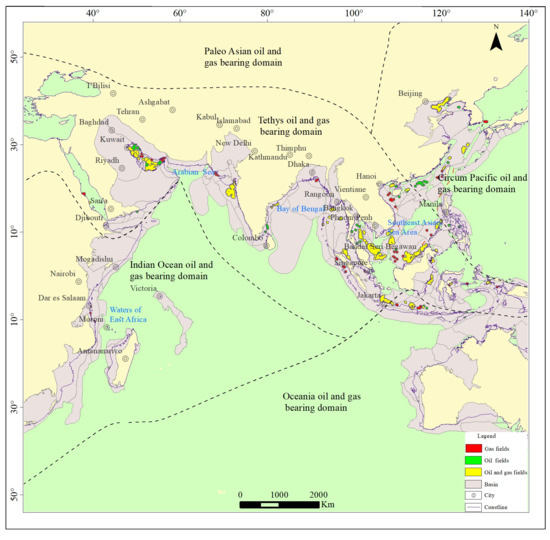
Figure 2.
Distribution map of oil and gas resources along the Silk Road.
Approximately 163 basins are dispersed across both the maritime and terrestrial domains of the Silk Road countries (Appendix A). These basins predominantly lie within the oil- and gas-rich sectors of the Neotethyan and Indian Ocean domains. According to oil and gas reserve data from the US Geological Survey (USGS) and BP, the Silk Road region boasts proven reserves totaling 2.973 billion tons of oil equivalent, encompassing 1.722 billion tons of oil and 1.251 billion tons of natural gas equivalent (Table 1). Furthermore, prospective reserves amount to 986 million tons of oil equivalent, including 431 million tons of oil and 555 million tons of natural gas equivalent (Table 2). Along the Silk Road, there exist 128 oil and gas fields. These fields, in terms of the geological eras in which their reservoirs were formed, are primarily associated with the Mesozoic and Cenozoic epochs. Regarding the lithological composition of these reservoirs, they are predominantly composed of sandstone and carbonate rocks. As for trap types, structural traps represent the predominant category (Figure 3).

Table 1.
Quantities of oil and gas resources in different Silk Road regions.
Table 2.
Status of oil and gas basins in Silk Road countries.
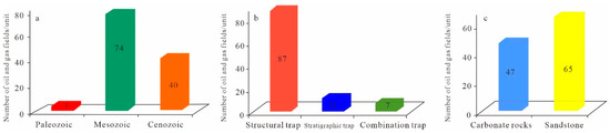
Figure 3.
Characteristics of oil and gas fields along the Silk Road ((a) the geological age of the reservoir; (b) trap types of oil and gas fields; (c) the lithology of the reservoir).
The Bay of Bengal emerges as a promising locale for oil and gas resources in South Asia [29,30]. Since the 1990s, there has been a succession of discoveries of gas fields in the shallow waters of the Bay of Bengal. Recent years have witnessed intensified efforts by Bangladesh, Myanmar, and India in the realm of deepwater oil and gas exploration within the Bay of Bengal, yielding substantial breakthroughs. It is estimated that approximately 2.6 trillion cubic meters of natural gas reserves still remain within this region.
The distribution of oil and gas resources in Southeast Asian waters primarily centers on Thailand, Malaysia, and Indonesia [30,31]. Thailand’s oil and gas resources are predominantly dominated by natural gas, primarily concentrated in the Gulf of Thailand basin. Currently, Thailand supports nearly 120 active oil and gas fields, with over half of them located offshore. Key fields, including the Benchams Oil Field, Plamuk Oil Field, Jasmine Oil Field, Arthit Gas Field, and Pailin Gas Field, are all situated within the Gulf of Thailand basin [32]. Malaysia’s principal oil and gas areas encompass the Gulf of Thailand-Malay Basin, the Sarawak Basin, and the Sabah Basin. These regions hold undiscovered oil resources amounting to 480 million tons and untapped natural gas resources of 360.9 billion cubic meters. Indonesia, rich in oil and gas resources, features predominantly onshore oil reserves, while over 70% of its natural gas resources are situated offshore, primarily within the Natuna Sea and the East Kalimantan Sea. Additionally, the offshore region shared by Indonesia and East Timor equally boasts substantial oil and gas resources.
Since 2006, East Africa has achieved significant strides in the field of oil and gas exploration. To date, multiple favorable zones for oil and gas resources have been identified in coastal and deepwater areas [18,33,34]. Offshore oil and gas resources are principally concentrated in the waters proximate to Mozambique and Tanzania. Mozambique’s territorial waters have revealed 13 gas fields with proven geological reserves totaling 5.3 trillion cubic meters and recoverable reserves of 4.1 trillion cubic meters. Tanzania, meanwhile, has approximately 50 offshore drilling sites, leading to the discovery of 21 gas fields with proven geological reserves of 1.35 trillion cubic meters and recoverable reserves of 104 million cubic meters [35,36].
3.2. Characteristics of Deepwater Oil and Gas Resources along the Silk Road
3.2.1. The Neotethyan Deepwater Basin Group
- (1)
- The deepwater region of the Bay of Bengal
Situated in the eastern part of the Indian subcontinent, west of the Myanmar–Andaman–Sumatra region, and offshore in southern Bangladesh, the Bay of Bengal is an area rich in continental margin basins holding substantial reserves of oil and gas. These basins can be categorized into three groups based on tectonic positions and structural attributes. The first group comprises passive continental margin basins on the western side, including Mahanadi, Krishna-Godavari, Gavil Garh, Mumbai, Indus Fan, and Kutch basins. The second group encompasses active continental margin basins on the eastern side, such as Rakhine, Maday Island, Andaman, and North Sumatra basins. The third group constitutes the northern residual ocean basins, particularly the Bay of Bengal basin itself. Oil and gas exploration in the Bay of Bengal predominantly involves India, Myanmar, and Bangladesh. Currently, major exploration activities in this region are centered around onshore and shallow-water regions adjacent to these basins. Recent years have witnessed significant discoveries of deepwater natural gas in the Krishna-Godavari, Gavil Garh, and Rakhine basins, confirming the substantial potential for natural gas exploration in this area.
In the Bay of Bengal region, hydrocarbon source rocks primarily date back to the Paleogene and Cretaceous periods, followed by the Neogene [37]. These source rocks developed mainly in shallow marine and deltaic environments. Shallow marine source rocks are concentrated in the Gavil Garh basin, while deltaic source rocks are widespread and predominantly composed of coal and carbonaceous shale. These source rocks are found along the peripheries of the Indian subcontinent, notably in the Paleocene to Early Eocene deltaic shale in the Bay of Bengal basin. With the exception of limestone, found in the interior of the Indian subcontinent, most basins are predominantly composed of shale and occasionally interspersed with coal-bearing strata (Table 3). The sedimentary environments in the Bay of Bengal region predominantly include nearshore, deltaic, and fluvial settings. During the rifting phase, alluvial fans, fluvial, and deltaic sandstone deposits were prominent. Subsequently, in the post-rift phase, shallow marine, deltaic, and deep fan sandstones, as well as extensive carbonate rocks, became prevalent. The primary cap rocks are of Neogene origin, followed by those from the Mesozoic. Shale is the dominant lithology, with coal beds and compact carbonates being the secondary components [38,39].
Table 3.
Notable oil and gas discoveries in the deepwater region of the Bay of Bengal [9,12].
- (2)
- Deepwater regions of Southeast Asia
The deepwater regions of Southeast Asia are renowned for their abundant oil and gas resources, constituting approximately 17% of the world’s deepwater reserves. While the overall exploration activities in these deepwater areas are relatively active, the depth of exploration remains modest. Recent years have witnessed a surge in offshore oil and gas exploration, leading to the discovery of multiple deepwater oil and gas fields across various basins and deepwater blocks in the Southeast Asian region, including Brunei-Sabah, Palawan, Zengmu, and Kutai. These discoveries underscore the considerable exploration potential within these deepwater zones.
Situated at the convergence of the Eurasian, Indo-Australian, and Pacific tectonic plates, Southeast Asia has undergone a complex geological evolution marked by plate collisions, amalgamations, and an array of geological processes. This dynamic history has given rise to diverse sedimentary basins, comprising active continental margin basins, cratonic basins, passive continental margin basins, and foreland basins. Among the more than 100 sedimentary basins in Southeast Asia, 47 have successfully uncovered oil and gas resources, rendering the region exceptionally rich in oil and gas. It is worth noting that there are over 400 established Paleogene oil and gas fields, estimated to hold approximately 1.195 billion tons of resources. Furthermore, there are in excess of 1500 recognized Neogene oil and gas fields, collectively hosting around 12.024 billion tons of resources [40]. The most recent data reveal a substantial number of deepwater oil and gas fields within close proximity to Kalimantan Island, underscoring the enormous exploration potential in Southeast Asia’s deepwater domains (Table 4). In the offshore basins of Southeast Asia, hydrocarbon source rocks primarily consist of Cenozoic deltaic coal and carbonaceous shale, as well as lacustrine and marine shale. These source rocks predominantly date back to the Eocene, Oligocene, and Middle Miocene. The reservoirs are primarily composed of Cenozoic deep-sea turbidite sandstones. These deepwater regions are poised to become the principal focal points for oil and gas exploration and production in Southeast Asian nations.
Table 4.
Significant oil and gas discoveries in the deepwater areas of Southeast Asia [9,12].
- (3)
- The deepwater region of the Arabian Sea
The Indus Fan stands as the world’s second-largest deep-sea fan, situated within Pakistan’s exclusive economic zone in the Arabian Sea. The exploration focus extends to the upper Indus Fan, and the adjoining shallow-water continental shelf area has captured significant attention. To date, 14 wells have been drilled in the nearshore basin of the Indus Fan. Regrettably, only one, Well Pakcan-1, encountered natural gas within the continental shelf area [41]; however, it did not meet industrial production standards. Well-core tests reveal that the Upper to Middle Miocene shales serve as excellent to very good source rocks in this region, exhibiting an approximate thickness of 300 m and an average total organic carbon (TOC) content of 2%. It is hypothesized that potential source rocks in the Indus Fan area primarily belong to the Cretaceous and Paleogene shales, predominantly characterized by Type III organic matter, spanning from maturation to over-maturation [42]. The reservoir predominantly consists of Miocene sandstones and Paleocene reef limestone or shoal limestone (Figure 4). Among these, the Miocene sandstones, encountered in Well PakCan-1, range from 2 to 50 m in thickness with porosities between 15% and 20%. The reef limestone and shoal limestones from the Paleocene to Eocene, discovered in Well PaK-G2-1, exhibit porosities exceeding 20% [43]. While the entire region lacks a continuous shale cap rock, the localized development of shale cap rocks is evident, particularly in the thick upper segments of the Middle Miocene shale layers. These cap rocks are widely distributed and can serve as regional cap rocks. The latest seismic data interpretation suggests that the nearshore basin of the Indus Fan features multiple source rocks, with both Miocene fluvial sand in the continental shelf area and Eocene reef limestone in the deepwater region being prevalent, indicating excellent reservoir quality and promising prospects for oil and gas exploration in the deepwater areas (Figure 5).
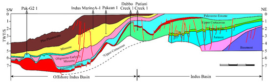
Figure 4.
Geoseismic section from onshore Lower Indus to deep offshore Indus [43].
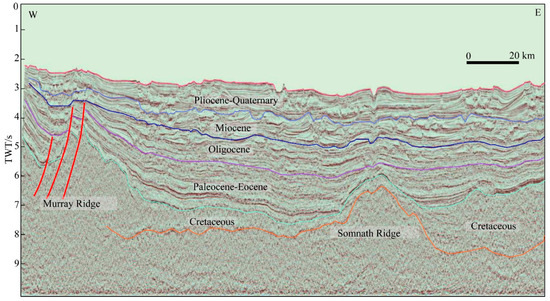
Figure 5.
Seismic profile of the Indian fan offshore basin [41].
3.2.2. Deepwater Basin Groups along the East African Continental Margin
In recent years, the deepwater regions of East Africa have witnessed remarkable advancements compared to North and West Africa, marked by the discovery of world-class deepwater gas fields in basins such as Rovuma and Tanzania. Despite oil and gas exploration efforts commencing in the 1950s, limited activities and a lack of exploration wells hindered significant discoveries until the 1990s. Before then, only small-scale oil and gas reservoirs were identified. By 2010, a total of 232 wells had been drilled, mainly in onshore and shallow-water areas (less than 100 m in depth), with minimal success. Seven small to medium-sized commercial natural gas fields were found in onshore and shallow-water areas, spanning Somalia, Mozambique Coastal Basin, Tanzania, and the Rovuma Basin [35,43,44]. A turning point occurred in 2010 with the discovery of 12 substantial gas fields in the deepwater areas of East Africa, at an average depth of approximately 1650 m, resulting in a cumulative proven reserve of 2.7 trillion cubic meters [44]. This has positioned the region as a focal point for global oil and gas exploration activities in recent years and stands as a pivotal domain for deepwater oil and gas exploration, as evidenced by two of the top ten global oil and gas exploration discoveries in 2011 and seven in 2012 emerging from East Africa (Table 5).
Table 5.
Recent discoveries in oil and gas exploration in the deepwater regions of the East African coast.
At present, petroleum reservoirs discovered along the East African coast are predominantly natural gas, concentrated in the northern segment. In contrast, Madagascar focuses primarily on heavy oil and oil sands, mirroring the structural attributes of the northern region [45,46]. Major gas fields identified in the Rovuma and Tanzania basins are situated in the deepwater areas west of the Davie Fault Zone (DFZ). Specifically, in the Rovuma Basin, major gas fields are chiefly located within the offshore thrust fault zone and its foreland, with no significant gas fields identified in the nearby normal fault development zone. In the Tanzania Basin, major gas fields are distributed along the north–south direction of normal fault lines (Figure 6).
The East African coast is characterized by two sets of effective source rocks spanning from the Carboniferous to the Lower Jurassic and from the Middle to Upper Jurassic through to the Cretaceous [43,47]. The Carboniferous to Lower Jurassic source rocks consist mainly of continental shale and coal series, featuring mainly type II-III kerogen types with a maximum thickness of nearly one hundred meters. These source rocks, primarily found in the eastern sectors of the Somali Basin, central areas of the Lamu Basin, Tanzania Basin, Rovuma Basin, and eastern extents of the Mlindiwa Basin, are highly evolved and generally mature or over-mature, contributing primarily to gas. Notably, Nondwa evaporites and Mbuo shales of the Lower Jurassic serve as exceptional source rocks in the Tanzania Basin. Meanwhile, the Middle to Upper Jurassic and Cretaceous source rocks exhibit widespread distribution and are characterized by high-quality attributes. Among these, the Tanzania, Rovuma, and Somalia basins exhibit the most favorable source rock conditions. The primary source rocks in this context are the Bajocian shales of the Middle to Upper Jurassic and the black shales of the Campanian stage in the Upper Cretaceous.
Multiple sets of reservoirs have developed within the sedimentary basins of the African East Coast. Reservoirs from the Permo-Triassic to the Neogene showcase robust petrophysical properties [48]. In addition to the Karoo Group continental clastic rock reservoirs, the other primary reservoirs comprise Middle to Upper Jurassic clastic rocks, Cretaceous to Neogene marine clastic rocks, and carbonates. Clastic rock reservoirs predominantly consist of deltaic and nearshore turbidite sandstones, while carbonate reservoirs primarily comprise biogenic reefs or clastic limestone, shallow marine limestone, post-reef oolitic limestone, and shelf carbonate rocks.
Cap rocks within the sedimentary basins of the East African coast predominantly consist of shale, mudstone, and marl. Notably, the Somali Basin, Tanzania Basin, Mlindiwa Basin, and Rovuma Basin feature substantial layers of evaporites, which serve as crucial cap rocks [49].
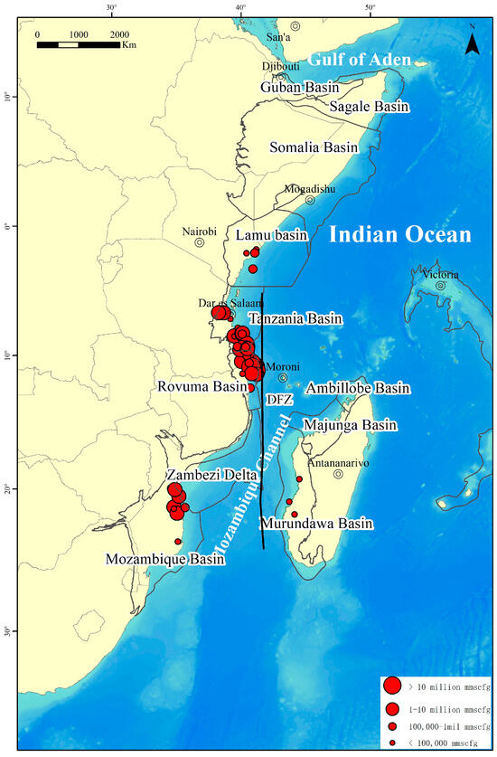
Figure 6.
Distribution map of oil and gas fields along the East African coast [50].
4. Geological Characteristics of Deepwater Basin Groups along the Silk Road
The deepwater basin groups along the Silk Road exhibit a predominant “horizontal and vertical” distribution (Figure 7). The “horizontal” distribution primarily corresponds to east–west-oriented deepwater basin belts within the Neotethyan tectonic domain, situated along passive continental margins. These areas initially experienced extension during the passive continental margin phase and later underwent compression due to collisional mountain-building processes. Included in this category are the deepwater basins of the northern continental margin of the South China Sea, the Zengmu Basin, the Brunei-Sabah Basin in the southern South China Sea, the deepwater basins within the Gulf of Myanmar, the deepwater basins of the Bay of Bengal, and the deepwater basins within the Arabian Gulf. The “vertical” distribution primarily pertains to the north–south-oriented East African continental margin deepwater basin groups, characterized as typical passive continental margin basins in an extensional setting, including the Somalia Basin, Rovuma Basin, Tanzania Basin, and Mozambique Basin.
Figure 7.
Distribution of deepwater basins along the Silk Road.
4.1. Geological Characteristics of Deepwater Basin Groups in the Neotethyan Tectonic Domain
The Tethys tectonic domain, an east–west-oriented oceanic trench that separated the Laurasia and Gondwana supercontinents from the Early Paleozoic to the Late Cretaceous [36,51,52], played a crucial role in shaping the deepwater basin groups within the Neotethyan tectonic domain. The Tethys Ocean’s formation was initiated during the Late Permian period, marking the initial rift in the eastern Gondwana continent. It evolved into a mid-Mesozoic oceanic basin [53,54], situated between the Cimmerian continent(s) and the eastern Gondwana continent. The Jurassic period witnessed the substantial expansion of the Tethys Ocean, fostering the development of intraplate basins and passive continental margin sedimentation. Subsequently, during the Cretaceous period, the subduction of the Tethys Ocean beneath the Eurasian Plate commenced, transforming its northern margin into an active continental margin during the Late Cretaceous. The Early to Middle Eocene period saw the gradual closure of the Tethys Ocean due to the rapid collision between the Indian Plate and the Eurasian Plate. This collision displaced fragments, such as the Sunda Block and the Indochina Block southeastward, giving rise to Neogene arc–forearc basins and back-arc rift basins.
In Southeast Asia, as an illustrative case, there were three distinct phases of structural evolution: rifting, thermal subsidence, and inversion [55]. During the Early Neogene to Early Miocene, the region primarily underwent the rift development phase, marked by prevalent fluvial and lacustrine clastic sedimentation. By the Late Miocene, a notable marine transgression took place, transitioning from terrestrial to marine sedimentary environments, resulting in the deposition of extensive shallow marine mudstone and carbonate sediments. In the Late Middle Miocene, the subduction of the young oceanic crust under the continental margin induced regional compression and strike-slip events, often accompanied by repeated sea-level fluctuations. These processes contributed to the development of extensive delta-front and submarine fan sedimentation.
4.2. Geological Characteristics of Deepwater Basin Groups in the East African Continental Margin
The East African passive continental margin basin groups, shaped by geological processes, including the rifting of the eastern Gondwana continent and the Indian Ocean expansion, underwent three principal phases of structural evolution, resulting in a dual-layer structure known as “lower faulted-upper tilted” [44,47]. The rift phase commenced in the Early Carboniferous period marked the onset of the rift phase, as the Karoo mantle plume became active in the eastern Gondwana continent, causing crustal uplift, intense faulting, and volcanic activity. This phase led to the formation of rift-type grabens [56], primarily filled with terrestrial fluvial, lacustrine, and coal-bearing sediments. During the Middle Jurassic period, the rift extended from northwest to southeast within the Gondwana continent, resulting in significant subsidence in regions like modern-day Somalia, Tanzania, and Madagascar. Additionally, a substantial marine transgression occurred, establishing a system of continental shelf carbonate platforms [57] and transitioning the environment from fluvial and lacustrine to marine sedimentary environments. In the southern region, the Mozambique Basin, located on the margin of the Karoo Basin, experienced intense volcanic activity and the deposition of abundant volcanic rocks [49]. During the Late Jurassic to Early Cretaceous, as drifting continued, the eastern Gondwana continent moved southward, and the ocean floor continued to expand. The connection of the northern and southern Indian Oceans resulted in rising sea levels, contributing to the development of widespread marine sedimentary environments, which overlay the underlying rift sedimentary layers [48]. By the Late Cretaceous, the region entered a passive continental margin phase marked by robust volcanic activity and a substantial supply of coarse clastic materials. During the Paleogene and Neogene periods, as global sea levels fluctuated, the region featured diverse sedimentary environments, including lagoon, intertidal, supratidal, shallow marine carbonate platform, nearshore turbidite, and deep-marine deposits.
5. Controlling Factors and Exploration Potential
5.1. Substrate for Deepwater Gas Field Formation
In deepwater environments, a variety of source rocks hold the potential to yield oil and gas. Oil source rocks encompass lacustrine, open-marine, and dispersed organic materials. Gas sources encompass dispersed organic materials generating both biogenic and thermogenic gas, originating from source rocks surpassing the oil generation threshold. Notably, world-class oil and gas fields are present in the Jurassic, Cretaceous, and Paleogene strata (Figure 8).
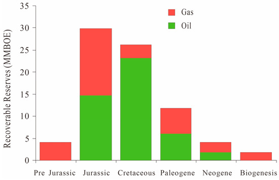
Figure 8.
Relationship between deepwater recoverable reserves and hydrocarbon source rock ages.
The Silk Road region exhibits a sequence of continental rifts and passive continental margin basin groups formed during the fragmentation of the Gondwana Plate and the initiation of new plate tectonics. Having evolved through successive structural and sedimentary alterations, these basins provide favorable conditions for petroleum geology and diverse accumulation scenarios. Hydrocarbon source rocks are predominantly distributed in Mesozoic and Cenozoic strata, appearing in various types, such as platform-to-basin carbonates (predominantly marl), dark mudstones, carbonaceous mudstones, carbonaceous shales, and coal, often within littoral and transitional marine settings. Reservoirs primarily fall into two categories: carbonate rocks and clastic rocks. Carbonate rock reservoirs consist mainly of dolomitic limestone found within shallow marine carbonate platforms, delta fronts, and deep-sea shelf environments. Clastic rock reservoirs, on the other hand, are primarily composed of distributary channel sandstones, beach sandstones, and deepwater fan sandstones located in delta and shoreface depositional systems. These sandstones exhibit well-developed sorting and roundness, possessing a high degree of structural and compositional maturity. Cap rocks are predominantly composed of deep-sea mudstones. Mesozoic and Cenozoic deepwater basins, subjected to multiple phases of tectonic activity, have created various trap types, including uplifts, rollover anticlines, large gravity structures, and tilted fault blocks, all exhibiting strong hereditary characteristics. Currently, deepwater regions globally are in the early stages of exploration, characterized by limited drilling activity, promising a high potential and a high likelihood of discovering significant oil and gas accumulations. Ongoing exploration efforts focus on confirmed hydrocarbon-rich basins and newly established basins. Large structural-type oil and gas fields remain dominant, with numerous substantial structural traps yet to be drilled. These traps encompass various types associated with gravitational detachment structures and tilted fault block structures, especially ultra-deepwater and deep-seated traps and those characterized by complex structural and lithological settings.
5.2. Efficient Systems for Oil and Gas Migration
In deepwater regions, oil and gas migration is observed to manifest through various methods, including long-distance and short-distance transport. Following hydrocarbon generation in source rocks, an efficient migration system transports them to suitable traps for accumulation. Faults, salt tectonics, and sand bodies act as efficient conduits for oil and gas migration [9,58].
The concentration of oil and gas in the Bay of Bengal correlates closely with the distribution of large rivers and deltas. Primary reservoir combinations in the Middle Miocene of the North Sumatra Basin are associated with marine deltaic depositional environments. After hydrocarbon generation, migration occurs through interconnected sand bodies, fault surfaces, and mud diapirism, resulting in their accumulation within large river-delta and deepwater turbidite fan deposits. These accumulations are notably focused within lithological and structural traps, as well as rollover anticlinal traps.
In the deep-sea regions of the East African continental margin, faults significantly control the formation of oil and gas accumulations, providing crucial migration pathways. Major oil and gas fields are predominantly distributed on both sides of the Davie Fault Zone (DFZ), characterized by interconnected faults linking source rocks. The practices of global deepwater oil and gas exploration highlight that anticlines within deepwater fold–thrust belts, particularly those masked by reverse faults on one side, represent the most probable structural traps for the discovery of industrial oil and gas [59,60]. The Mamba gas field, discovered in the Rovuma Basin, is situated on the eastern leading edge of the reverse thrust within the deepwater fold–thrust belt. As a result of reverse fault activity, numerous fault-related anticlinal rollovers have developed in the upper section of the reverse fault, establishing excellent structural traps [61,62]. Additionally, the region features extensive deepwater turbidite fans with well-connected sand bodies and favorable reservoir properties, making it an efficient, high-quality reservoir. Early oil and gas, primarily gaseous, generated from marine source rocks, migrated along eastern faults connecting source rocks and filled the Paleogene sand bodies, forming lithological and structural oil and gas traps [48].
A large amount of oil and gas has been discovered in the Ruvuma Basin and the Tanzania Basin in East Africa, as well as in the Rakhine Basin in Myanmar [14,63]. The reservoir is mainly composed of river-channel and turbidite sandstones, shaped through the combined effects of gravity flow and bottom flow. Deepwater sedimentary bodies are mutually eroded, laterally migrated, and vertically stacked, exhibiting complex spatiotemporal relationships. They are formed by the migration and stacking of sedimentary units from distinct periods, showcasing complex vertical changes and strong heterogeneity. For instance, the Paleogene reservoirs in the Luwuma Basin of East Africa are mainly composed of channel and cluster sedimentation [63,64]. Due to the simultaneous influence of bottom flow during sedimentation, turbidite sand bodies in this area have evolved into high-quality reservoirs with pure sand and favorable petrophysical properties. The lateral migration and vertical stacking of channels and clusters have contributed to the substantial scale and thickness of sand bodies, creating optimal reservoir conditions.
5.3. Exploration Prospects
To date, the deepwater regions along the Silk Road have yielded numerous oil and gas discoveries. Deepwater exploration activities in Southeast Asian waters have been highly active, resulting in 17 significant discoveries, primarily concentrated in countries such as Malaysia, Indonesia, China, and Vietnam. In East African waters, there have been 23 discoveries, including 7 in Mozambique and 16 in Tanzania, with an estimated resource quantity of 3.772 billion tons of oil equivalent. India and Myanmar have also identified several deepwater natural gas deposits in the Bay of Bengal, accounting for six oil and gas discoveries. Disparities in oil and gas discoveries, resource potential, exploration levels, and research are evident among the deepwater basins along the Silk Road (Figure 9). Currently, the major oil and gas fields found are predominantly of the structural trap type (Figure 9), leaving numerous unexplored complex traps, lithological traps, and structural traps in deepwater areas that await drilling. Abundant resources with immense potential characterize the deepwater oil and gas deposits along the Silk Road. A comparative analysis of the geological conditions and resource potential suggests that the overall exploration levels in deepwater areas are relatively low, presenting substantial opportunities for discovering large and giant oil and gas fields. Many exploration targets exhibit significant promise and warrant further investigation.
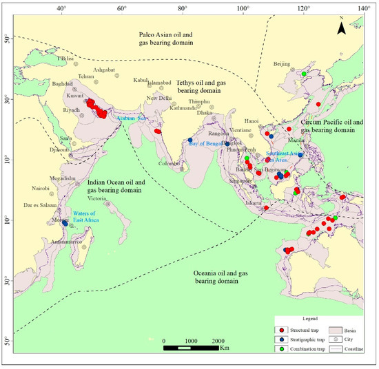
Figure 9.
Main types of oil and gas traps along the Silk Road.
In the nearshore areas of the Bay of Bengal, the exploration level for oil and gas is relatively high, but the deepwater region offers promising prospects. The Bay of Bengal, forming a vast river-delta system, gives rise to various types of continental margin basins with substantial organic matter input along the continental margin. The conditions for hydrocarbon accumulation are exceptional, particularly in the deep-sea regions where Neogene turbidite sandstones extend. The primary exploration goal is to identify lithological traps. In the eastern seabed of Pakistan’s waters, material primarily originates from the Indus River, resulting in the widespread distribution of Miocene river-channel sandstones and Eocene reef limestones in deepwater regions. These areas boast high-quality reservoirs and promising prospects for oil and gas exploration, with an emphasis on identifying lithological traps [41]. Southeast Asian waters, situated at the convergence of three major tectonic plates, have undergone complex tectonic evolution, resulting in various basin types. Hydrocarbon resources are concentrated in Cenozoic back-arc basins, rift basins, passive margin basins, and foreland basins. In the deepwater region of Southeast Asia, numerous thrust–fold belts have developed, prominently featuring structural traps. The conditions for hydrocarbon accumulation are excellent, with the primary objective being the identification of large structural-type oil and gas fields.
East African waters exhibit typical passive continental margin basins characterized by abundant petroleum geological conditions, multiple sets of source rocks, favorable cap rock and reservoir combinations, and well-developed structural and lithological traps. Current drilling results suggest that the favorable direction for exploration in the deepwater region off the East African coast should focus on lithological traps formed by the development of Neogene biogenic reefs and seafloor turbidite sandstones.
6. Conclusions
The principal deepwater oil and gas basins along the Silk Road exhibit a distinct “horizontal and vertical” distribution pattern. This primarily includes deepwater basin groups along the East African continental margin, the Western Pacific region, the Bay of Bengal in the Neotethyan region, and the deepwater basins of the Arabian Gulf. The oil and gas resources along the Silk Road hold tremendous potential, with the Arabian Sea being the primary focus, followed by Southeast Asia and East Africa. These resources are mainly distributed in the Middle to Late Cenozoic, primarily in structural traps, featuring carbonate rocks and sandstones as primary reservoirs. Looking toward the future, deepwater areas are poised to become the primary regions for augmenting oil and gas reserves and production in Southeast Asian nations. Within the Neotethyan region, the Bay of Bengal and the Pakistani waters hold promising prospects for deepwater basin natural gas exploration, while East Africa emerges as a global hotspot for natural gas exploration.
The deepwater basins along the Silk Road lay the material groundwork for significant oil and gas fields. Source rocks primarily consist of lacustrine, coal-bearing, and marine shales. Various reservoir types, notably deep-sea turbidite rocks and biogenic reefs, take center stage. These regions boast well-developed cap rocks and efficient oil and gas migration pathways. In the deepwater expanses of the Bay of Bengal, the primary emphasis is on lithological traps formed by Neogene turbidite sandstones. In the deepwater regions off Pakistan, the focus shifts to lithological traps formed by Neogene biogenic reefs and river-channel sandstones. In Southeast Asian deepwater areas, the primary objective is to unearth large structural-type oil and gas fields. Along the East African coast in deepwater regions, exploration efforts should concentrate on lithological traps formed by the development of Neogene biogenic reefs and seafloor turbidite sandstones.
Author Contributions
Conceptualization, J.W., Q.Z. and H.D.; methodology, J.W. and Y.Y.; writing—original draft, J.W., J.C., J.L. and J.Z.; writing—review and editing, Y.Z.; supervision, J.C. and J.L. All authors have read and agreed to the published version of the manuscript.
Funding
This research was jointly supported by the Laoshan Laboratory (LSKJ202203404, LSKJ202203401), the Project of China Geology Survey (DD20221723, DD20230317), the National Natural Science Foundation of China (41776075, 42076220, 42206234), Natural Science Foundation of Shandong Province (No. ZR2020QD038, ZR2022MD054), and the Major Basic Research Projects of Shandong Province (No. ZR2021ZD09).
Data Availability Statement
All the data and materials used in this paper are available from the corresponding authors upon request.
Conflicts of Interest
The authors declare that there are no competing financial interests with any other people or groups regarding the publication of this manuscript.
Appendix A. Characteristics of Basins along the Silk Road
| Fid | Basin Name | Basin Location | Exploration Status | Offshore Location | Basin Type |
| 1 | Great Australian Bight | Australia South Coast | Little Explored | Offshore | Divergent Basin |
| 2 | Mozambique Channel Ultradeep | East Africa | Unexplored | Offshore | Divergent Basin |
| 3 | Lamu Embayment Ultradeep | East Africa | Unexplored | Offshore | Divergent Basin |
| 4 | Majunga Ultradeep | East Africa | Unexplored | Offshore | Divergent Basin |
| 5 | Rovuma Ultradeep | East Africa | Unexplored | Offshore | Divergent Basin |
| 6 | Tanzanian Coastal Ultradeep | East Africa | Unexplored | Offshore | Divergent Basin |
| 7 | Tomori | Eastern Indonesia | Partially Explored | Offshore | Divergent Basin |
| 8 | Tukang Besi | Eastern Indonesia | Unexplored | Offshore | Convergent (Ocean–Continent) Basin |
| 9 | Salabanga Manui | Eastern Indonesia | Little Explored | Offshore | Divergent Basin |
| 10 | Flores | Eastern Indonesia | Little Explored | Offshore | Convergent (Ocean–Continent) Basin |
| 11 | Savu | Eastern Indonesia | Little Explored | Offshore | Convergent (Ocean–Ocean) Basin |
| 12 | Gorontalo | Eastern Indonesia | Unexplored | Offshore | Convergent (Ocean–Continent) Basin |
| 13 | Saya De Malha Bank | India and the Seychelles | Unexplored | Offshore | Divergent Basin |
| 14 | Offshore Indus Ultradeep | India and the Seychelles | Little Explored | Offshore | Divergent Basin |
| 15 | Indian Ocean Abyssal | India and the Seychelles | Unexplored | Offshore | Divergent Basin |
| 16 | Kachchh-Mumbai Ultradeep | India and the Seychelles | Little Explored | Offshore | Divergent Basin |
| 17 | Mumbai-Konkan Ultradeep | India and the Seychelles | Unexplored | Offshore | Divergent Basin |
| 18 | Mannar Ultradeep | India and the Seychelles | Unexplored | Offshore | Divergent Basin |
| 19 | Outer Bengal Fan | India and the Seychelles | Unexplored | Offshore | Divergent Basin |
| 20 | Nazareth Bank | India and the Seychelles | Unexplored | Offshore | Divergent Basin |
| 21 | Dangerous Grounds | Indo-China | Little Explored | Offshore | Divergent Basin |
| 22 | Malay | Indo-China | Well Explored | Offshore | Divergent Basin |
| 23 | Phu Khanh | Indo-China | Little Explored | Offshore | Divergent Basin |
| 24 | Nam Con Son | Indo-China | Partially Explored | Offshore | Divergent Basin |
| 25 | West Natuna-Penyu | Indo-China | Well Explored | Offshore | Divergent Basin |
| 26 | Khmer | Indo-China | Little Explored | Offshore | Divergent Basin |
| 27 | Browse | Northwest Australia | Partially Explored | Offshore | Divergent Basin |
| 28 | Tokara | Pacific Far East | Unknown | Offshore | Convergent (Ocean–Ocean) Basin |
| 29 | Nendo | Pacific Southwest | Unknown | Offshore | Convergent (Ocean–Ocean) Basin |
| 30 | East China Sea | Southeast China | Little Explored | Offshore | Convergent (Ocean–Continent) Basin |
| 31 | Qiongdongnan | Southeast China | Partially Explored | Offshore | Divergent Basin |
| 32 | Xisha | Southeast China | Unexplored | Offshore | Divergent Basin |
| 33 | Zhongsha Plateau | Southeast China | Little Explored | Offshore | Divergent Basin |
| 34 | Shuangfeng | Southeast China | Unknown | Offshore | Divergent Basin |
| 35 | Bijia | Southeast China | Unknown | Offshore | Divergent Basin |
| 36 | Andaman Sea | Western Indonesia | Unknown | Offshore | Convergent (Ocean–Continent) Basin |
| 37 | Biliton | Western Indonesia | Little Explored | Offshore | Convergent (Ocean–Continent) Basin |
| 38 | Gippsland | Australia South Coast | Well Explored | Onshore and Offshore | Divergent Basin |
| 39 | Eucla | Australia South Coast | Little Explored | Onshore and Offshore | Divergent Basin |
| 40 | Polda | Australia South Coast | Little Explored | Onshore and Offshore | Divergent Basin |
| 41 | Bass | Australia South Coast | Partially Explored | Onshore and Offshore | Divergent Basin |
| 42 | Karoo | Central and South Africa Interior | Little Explored | Onshore and Offshore | Convergent (Ocean–Continent) Basin |
| 43 | Outeniqua | Circum-South Atlantic (Africa) | Partially Explored | Onshore and Offshore | Divergent Basin |
| 44 | Rovuma | East Africa | Little Explored | Onshore and Offshore | Divergent Basin |
| 45 | Diego Ambilobe | East Africa | Little Explored | Onshore and Offshore | Divergent Basin |
| 46 | Mozambique | East Africa | Partially Explored | Onshore and Offshore | Divergent Basin |
| 47 | Tanzanian Coastal | East Africa | Partially Explored | Onshore and Offshore | Divergent Basin |
| 48 | Morondava | East Africa | Partially Explored | Onshore and Offshore | Divergent Basin |
| 49 | Lamu Embayment | East Africa | Partially Explored | Onshore and Offshore | Divergent Basin |
| 50 | Majunga | East Africa | Little Explored | Onshore and Offshore | Divergent Basin |
| 51 | Cagayan | East Philippines | Unknown | Onshore and Offshore | Convergent (Ocean–Ocean) Basin |
| 52 | Visayan-Iloilo-Masbate | East Philippines | Unknown | Onshore and Offshore | Convergent (Ocean–Continent) Basin |
| 53 | Agusan-Davao | East Philippines | Unknown | Onshore and Offshore | Convergent (Ocean–Ocean) Basin |
| 54 | Bicol Shelf | East Philippines | Unknown | Onshore and Offshore | Convergent (Ocean–Ocean) Basin |
| 55 | West Luzon | East Philippines | Unknown | Onshore and Offshore | Convergent (Ocean–Ocean) Basin |
| 56 | Cotabato | East Philippines | Unknown | Onshore and Offshore | Convergent (Ocean–Continent) Basin |
| 57 | Luzon-Ilocos Trough | East Philippines | Unknown | Onshore and Offshore | Convergent (Ocean–Ocean) Basin |
| 58 | Buton | Eastern Indonesia | Little Explored | Onshore and Offshore | Divergent Basin |
| 59 | North New Guinea | Eastern Indonesia | Little Explored | Onshore and Offshore | Convergent (Ocean–Continent) Basin |
| 60 | South Makassar | Eastern Indonesia | Little Explored | Onshore and Offshore | Convergent (Ocean–Continent) Basin |
| 61 | South Sumba | Eastern Indonesia | Unknown | Onshore and Offshore | Convergent (Ocean–Continent) Basin |
| 62 | Waipoga | Eastern Indonesia | Partially Explored | Onshore and Offshore | Wrench Basin |
| 63 | Seram | Eastern Indonesia | Partially Explored | Onshore and Offshore | Convergent (Ocean–Ocean) Basin |
| 64 | Sengkang Bone | Eastern Indonesia | Partially Explored | Onshore and Offshore | Divergent Basin |
| 65 | Buru | Eastern Indonesia | Unexplored | Onshore and Offshore | Convergent (Ocean–Ocean) Basin |
| 66 | Banggai Sula | Eastern Indonesia | Little Explored | Onshore and Offshore | Convergent (Continent–Continent) Basin |
| 67 | Lariang | Eastern Indonesia | Little Explored | Onshore and Offshore | Convergent (Continent–Continent) Basin |
| 68 | Papuan | Eastern Indonesia | Partially Explored | Onshore and Offshore | Convergent (Ocean–Continent) Basin |
| 69 | Salawati | Eastern Indonesia | Partially Explored | Onshore and Offshore | Wrench Basin |
| 70 | Viqueque | Eastern Indonesia | Partially Explored | Onshore and Offshore | Convergent (Ocean–Ocean) Basin |
| 71 | Halmahera | Eastern Indonesia | Unexplored | Onshore and Offshore | Convergent (Ocean–Continent) Basin |
| 72 | Kai-Aru Trough | Eastern Indonesia | Little Explored | Onshore and Offshore | Divergent Basin |
| 73 | Tanimbar | Eastern Indonesia | Unexplored | Onshore and Offshore | Convergent (Ocean–Ocean) Basin |
| 74 | Bintuni | Eastern Indonesia | Partially Explored | Onshore and Offshore | Wrench Basin |
| 75 | Weber | Eastern Indonesia | Unknown | Onshore and Offshore | Convergent (Ocean–Continent) Basin |
| 76 | Irian Arafura | Eastern Indonesia | Little Explored | Onshore and Offshore | Convergent (Ocean–Continent) Basin |
| 77 | North China | Eastern Paratethys | Well Explored | Onshore and Offshore | Divergent Basin |
| 78 | Jiao Liao | Eastern Paratethys | Unexplored | Onshore and Offshore | Divergent Basin |
| 79 | Krishna-Godavari | India and the Seychelles | Partially Explored | Onshore and Offshore | Divergent Basin |
| 80 | Mannar | India and the Seychelles | Little Explored | Onshore and Offshore | Divergent Basin |
| 81 | Kachchh | India and the Seychelles | Little Explored | Onshore and Offshore | Divergent Basin |
| 82 | Konkan-Kerala | India and the Seychelles | Little Explored | Onshore and Offshore | Divergent Basin |
| 83 | Tripura-Cachar Foldbelt-Bengal | India and the Seychelles | Partially Explored | Onshore and Offshore | Divergent Basin |
| 84 | Cambay | India and the Seychelles | Well Explored | Onshore and Offshore | Divergent Basin |
| 85 | Mumbai-Saurashtra | India and the Seychelles | Well Explored | Onshore and Offshore | Divergent Basin |
| 86 | Indus | India and the Seychelles | Well Explored | Onshore and Offshore | Convergent (Continent–Continent) Basin |
| 87 | Offshore Indus | India and the Seychelles | Little Explored | Onshore and Offshore | Divergent Basin |
| 88 | Bengal Delta Sub-basin-Bengal | India and the Seychelles | Partially Explored | Onshore and Offshore | Divergent Basin |
| 89 | Cauvery | India and the Seychelles | Well Explored | Onshore and Offshore | Divergent Basin |
| 90 | Mahanadi | India and the Seychelles | Little Explored | Onshore and Offshore | Divergent Basin |
| 91 | Seychelles Bank | India and the Seychelles | Little Explored | Onshore and Offshore | Divergent Basin |
| 92 | Moattama-Tanintharyi | Indo-China | Partially Explored | Onshore and Offshore | Convergent (Ocean–Continent) Basin |
| 93 | Greater Thai | Indo-China | Well Explored | Onshore and Offshore | Divergent Basin |
| 94 | Arakan | Indo-China | Little Explored | Onshore and Offshore | Convergent (Ocean–Continent) Basin |
| 95 | Bac Bo-Yinggehai | Indo-China | Partially Explored | Onshore and Offshore | Divergent Basin |
| 96 | Central Myanmar Tertiary | Indo-China | Partially Explored | Onshore and Offshore | Convergent (Ocean–Continent) Basin |
| 97 | Cuu Long | Indo-China | Partially Explored | Onshore and Offshore | Divergent Basin |
| 98 | Panjang | Indo-China | Unexplored | Onshore and Offshore | Divergent Basin |
| 99 | Greater Chao Phraya | Indo-China | Well Explored | Onshore and Offshore | Divergent Basin |
| 100 | Pattani | Indo-China | Well Explored | Onshore and Offshore | Divergent Basin |
| 101 | Sabah-Baram Delta | Indo-China | Well Explored | Onshore and Offshore | Convergent (Ocean–Continent) Basin |
| 102 | Sarawak-Luconia-East Natuna | Indo-China | Partially Explored | Onshore and Offshore | Divergent Basin |
| 103 | Ile St. Marie | Madagascar South and East | Little Explored | Onshore and Offshore | Divergent Basin |
| 104 | Cap St. Marie | Madagascar South and East | Unexplored | Onshore and Offshore | Divergent Basin |
| 105 | Makran Foldbelt | Middle East | Little Explored | Onshore and Offshore | Convergent (Ocean–Continent) Basin |
| 106 | Masirah | Middle East | Little Explored | Onshore and Offshore | Divergent Basin |
| 107 | Oman Mountains Foldbelt | Middle East | Partially Explored | Onshore and Offshore | Convergent (Continent–Continent) Basin |
| 108 | Rub al Khali | Middle East | Well Explored | Onshore and Offshore | Convergent (Continent–Continent) Basin |
| 109 | Widyan-North Arabian Gulf | Middle East | Well Explored | Onshore and Offshore | Convergent (Continent–Continent) Basin |
| 110 | Zagros Foldbelt | Middle East | Well Explored | Onshore and Offshore | Convergent (Continent–Continent) Basin |
| 111 | Perth | Northwest Australia | Well Explored | Onshore and Offshore | Divergent Basin |
| 112 | South Carnarvon | Northwest Australia | Partially Explored | Onshore and Offshore | Divergent Basin |
| 113 | Tosa | Pacific Far East | Unknown | Onshore and Offshore | Convergent (Ocean–Continent) Basin |
| 114 | Toki | Pacific Far East | Unknown | Onshore and Offshore | Convergent (Ocean–Continent) Basin |
| 115 | Okinawa Trough | Pacific Far East | Unknown | Onshore and Offshore | Convergent (Ocean–Continent) Basin |
| 116 | Ryukyu Forearc | Pacific Far East | Unknown | Onshore and Offshore | Convergent (Ocean–Continent) Basin |
| 117 | Suruga | Pacific Far East | Unknown | Onshore and Offshore | Convergent (Ocean–Continent) Basin |
| 118 | Miyazaki | Pacific Far East | Unknown | Onshore and Offshore | Convergent (Ocean–Continent) Basin |
| 119 | Central Solomon Trough | Pacific Southwest | Unknown | Onshore and Offshore | Convergent (Ocean–Ocean) Basin |
| 120 | Vanikolo | Pacific Southwest | Unknown | Onshore and Offshore | Convergent (Ocean–Ocean) Basin |
| 121 | Big Bay-Cumberland | Pacific Southwest | Unknown | Onshore and Offshore | Convergent (Ocean–Ocean) Basin |
| 122 | Woodlark Rise | Pacific Southwest | Unknown | Onshore and Offshore | Convergent (Ocean–Continent) Basin |
| 123 | Bougainville | Pacific Southwest | Unknown | Onshore and Offshore | Convergent (Ocean–Ocean) Basin |
| 124 | New Ireland | Pacific Southwest | Unknown | Onshore and Offshore | Convergent (Ocean–Ocean) Basin |
| 125 | Central Vanuatu | Pacific Southwest | Unknown | Onshore and Offshore | Convergent (Ocean–Ocean) Basin |
| 126 | Fiji | Pacific Southwest | Unknown | Onshore and Offshore | Convergent (Ocean–Ocean) Basin |
| 127 | Somali-Ogaden-Mandera Lugh | Red Sea, Gulf of Aden, and the Horn of Africa | Partially Explored | Onshore and Offshore | Divergent Basin |
| 128 | Southern Gulf of Aden | Red Sea, Gulf of Aden, and the Horn of Africa | Little Explored | Onshore and Offshore | Divergent Basin |
| 129 | Jiza’-Qamar | Red Sea, Gulf of Aden, and the Horn of Africa | Partially Explored | Onshore and Offshore | Divergent Basin |
| 130 | Mogadishu-Somali Coastal | Red Sea, Gulf of Aden, and the Horn of Africa | Little Explored | Onshore and Offshore | Divergent Basin |
| 131 | Sayhut | Red Sea, Gulf of Aden, and the Horn of Africa | Little Explored | Onshore and Offshore | Divergent Basin |
| 132 | Aden-Abiyan | Red Sea, Gulf of Aden, and the Horn of Africa | Little Explored | Onshore and Offshore | Divergent Basin |
| 133 | Sagaleh | Red Sea, Gulf of Aden, and the Horn of Africa | Partially Explored | Onshore and Offshore | Divergent Basin |
| 134 | Balhaf | Red Sea, Gulf of Aden, and the Horn of Africa | Little Explored | Onshore and Offshore | Divergent Basin |
| 135 | San Shui | South China | Unknown | Onshore and Offshore | Divergent Basin |
| 136 | Hangjiahu | South China | Unknown | Onshore and Offshore | Divergent Basin |
| 137 | Qinzhou | South China | Unknown | Onshore and Offshore | Divergent Basin |
| 138 | West Hainan | Southeast China | Partially Explored | Onshore and Offshore | Divergent Basin |
| 139 | Beibu Gulf | Southeast China | Partially Explored | Onshore and Offshore | Divergent Basin |
| 140 | Pearl River Mouth | Southeast China | Partially Explored | Onshore and Offshore | Divergent Basin |
| 141 | Subei-Yellow Sea | Southeast China | Partially Explored | Onshore and Offshore | Divergent Basin |
| 142 | Taiwan | Southeast China | Partially Explored | Onshore and Offshore | Convergent (Ocean–Continent) Basin |
| 143 | West Korea | Southeast China | Partially Explored | Onshore and Offshore | Divergent Basin |
| 144 | Sulu Sea | West Philippines | Partially Explored | Onshore and Offshore | Divergent Basin |
| 145 | South Palawan | West Philippines | Partially Explored | Onshore and Offshore | Divergent Basin |
| 146 | Mindoro | West Philippines | Partially Explored | Onshore and Offshore | Convergent (Continent–Continent) Basin |
| 147 | North Palawan | West Philippines | Partially Explored | Onshore and Offshore | Divergent Basin |
| 148 | Central Sumatra | Western Indonesia | Well Explored | Onshore and Offshore | Convergent (Ocean–Continent) Basin |
| 149 | North Sumatra-Mergui | Western Indonesia | Partially Explored | Onshore and Offshore | Convergent (Ocean–Continent) Basin |
| 150 | Northwest Java | Western Indonesia | Well Explored | Onshore and Offshore | Convergent (Ocean–Continent) Basin |
| 151 | Sunda | Western Indonesia | Well Explored | Onshore and Offshore | Convergent (Ocean–Continent) Basin |
| 152 | Kutei | Western Indonesia | Well Explored | Onshore and Offshore | Convergent (Ocean–Continent) Basin |
| 153 | East Java | Western Indonesia | Partially Explored | Onshore and Offshore | Convergent (Ocean–Continent) Basin |
| 154 | Tarakan | Western Indonesia | Partially Explored | Onshore and Offshore | Convergent (Ocean–Continent) Basin |
| 155 | Sibolga | Western Indonesia | Little Explored | Onshore and Offshore | Convergent (Ocean–Continent) Basin |
| 156 | Andaman-Nicobar | Western Indonesia | Little Explored | Onshore and Offshore | Convergent (Ocean–Continent) Basin |
| 157 | Barito | Western Indonesia | Partially Explored | Onshore and Offshore | Convergent (Ocean–Continent) Basin |
| 158 | Bengkulu | Western Indonesia | Little Explored | Onshore and Offshore | Convergent (Ocean–Continent) Basin |
| 159 | South Java | Western Indonesia | Little Explored | Onshore and Offshore | Convergent (Ocean–Continent) Basin |
| 160 | South Sumatra | Western Indonesia | Well Explored | Onshore and Offshore | Convergent (Ocean–Continent) Basin |
| 161 | Java Sea | Western Indonesia | Partially Explored | Onshore and Offshore | Convergent (Ocean–Continent) Basin |
| 162 | Pasir-Asem Asem | Western Indonesia | Little Explored | Onshore and Offshore | Convergent (Ocean–Continent) Basin |
| 163 | Sandakan | Western Indonesia | Partially Explored | Onshore and Offshore | Convergent (Ocean–Continent) Basin |
References
- Dou, L.; Wen, Z.; Wang, J.; Wang, Z.; He, Z.; Liu, X.; Zhang, N. Analysis of the World Oil and Gas Exploration Situation in 2021. Pet. Explor. Dev. 2022, 49, 1033–1044. [Google Scholar] [CrossRef]
- Murawski, S.A.; Hollander, D.J.; Gilbert, S.; Gracia, A. Deepwater Oil and Gas Production in the Gulf of Mexico and Related Global Trends; Springer International Publishing: Cham, Switzerland, 2020; pp. 16–32. [Google Scholar]
- Zhang, N.; Wang, Q.; Wang, J.; Hou, L.; Li, H. Characteristics of Oil and Gas Discoveries in Recent 20 Years and Future Exploration in the World. China Pet. Explor. 2018, 23, 44–53. [Google Scholar]
- Zhai, G.; Wang, S.; He, W. Hotspot Trend and Enlightenment of Global Ten-Year Hydrocarbon Exploration. Acta Petrol. Sin. 2012, 33, 14–19. [Google Scholar]
- Zou, C.; Zhai, G.; Zhang, G.; Wang, H.; Zhang, G.; Li, J.; Wang, Z.; Wen, Z.; Ma, F.; Liang, Y.; et al. Formation, distribution, potential and prediction of global conventional and unconventional hydrocarbon resources. Pet. Explor. Dev. 2015, 42, 13–25. [Google Scholar] [CrossRef]
- Wang, Z.; Wen, Z.; He, Z.; Chen, R.; Shi, H.; Chen, X. Characteristics and Enlightenment of New Progress in Global Oil and Gas Exploration in Recent Ten Years. China Pet. Explor. 2022, 27, 27–37. [Google Scholar]
- Cordes, E.E.; Jones, D.O.B.; Schlacher, T.A.; Amon, D.J.; Bernardino, A.F.; Brooke, S.; Carney, R.; DeLeo, D.M.; Dunlop, K.M.; Escobar-Briones, E.G.; et al. Environmental Impacts of the Deep-Water Oil and Gas Industry: A Review to Guide Management Strategies. Front. Environ. Sci. 2016, 4, 58. [Google Scholar] [CrossRef]
- Zhang, G.; Qu, H.; Zhao, C.; Zhang, F.; Zhao, Z. Giant discoveries of oil and gas exploration in global deepwaters in 40 years and the prospect of exploration. Nat. Gas Geosci. 2017, 28, 1447–1477. [Google Scholar]
- Zhang, G.; Qu, H.; Zhang, F.; Chen, S.; Yang, H.; Zhao, Z.; Zhao, C. Major New Discoveries of Oil and Gas in Global Deepwaters and Enlightenment. Acta Petrol. Sin. 2019, 40, 1–34. [Google Scholar]
- Tong, X.; Zhang, G.; Wang, Z.; Wen, Z.; Tian, Z.; Wang, H.; Ma, F.; Wu, Y. Distribution and Potential of Global Oil and Gas Resources. China Pet. Explor. 2018, 45, 727–736. [Google Scholar] [CrossRef]
- Yang, L.; Wang, L.; Pan, J. Situation and prospect of global deepwater oil and gas exploration and development. China Min. Mag. 2017, 26, 14–17. [Google Scholar]
- Zhang, G.; Mi, L.; Qu, H.; Feng, Y.; Fan, Y. A Basic Distributional Framework of Global Deepwater Basins and Hydrocarbon Characteristics. Acta Pet. Sin. 2011, 32, 369–378. [Google Scholar]
- QU, H.; Zhang, G. Distribution Framework and Main Factors Controlling Hydrocarbon Accumulation of Global Oil and Gas-Rich Deepwater Basins. Nat. Gas Geosci. 2017, 28, 1478–1487. [Google Scholar]
- Jamil, M.; Siddiqui, N.A.; Ahmed, N.; Usman, M.; Umar, M.; Rahim, H.U.; Imran, Q.S. Facies Analysis and Sedimentary Architecture of Hybrid Event Beds in Submarine Lobes: Insights from the Crocker Fan, NW Borneo, Malaysia. J. Mar. Sci. Eng. 2021, 9, 1133. [Google Scholar] [CrossRef]
- Jamil, M.; Siddiqui, N.A.; Usman, M.; Wahid, A.; Umar, M.; Ahmed, N.; Haq, I.U.; El-Ghali, M.A.K.; Imran, Q.S.; Rahman, A.H.A.; et al. Facies analysis and distribution of Late Palaeogene deep-water massive sandstones in submarine-fan lobes, NW Borneo. Geol. J. 2022, 57, 4489–4507. [Google Scholar] [CrossRef]
- Zhang, G.; Feng, Y.; Qu, H. Characteristics of Petroleum Geology of Global five Deep-Water Basin Belts. China Pet. Explor. 2022, 27, 11–26. [Google Scholar]
- Wen, Z.; Wang, J.; Wang, Z.; He, Z.; Song, Z.; Liu, X.; Zhang, N.; Ji, T. Analysis of the World Deepwater Oil and Gas Exploration Situation. Pet. Explor. Dev. 2023, 50, 1060–1076. [Google Scholar] [CrossRef]
- Oin, Y.; Zhang, G.; Liu, J.; Chen, Z.; Xiao, G. Geological settings, hydrocarbon accumulation conditions and exploration prospects of deep-water oil and gas in East Africa. China Pet. Explor. 2022, 27, 110–121. [Google Scholar]
- Qin, Y.; Zhang, G.; Ji, Z.; Li, Z.; Wu, Y.; Wang, X.; Liang, X. Geological Features, Hydrocarbon Accumulation and Deep Water Potential of East Indian Basins. Pet. Explor. Dev. 2017, 44, 691–703. [Google Scholar] [CrossRef]
- Zhang, G.; Liu, X.; Zhang, D.; Zhao, J.; Wen, Z.; Wang, Z.; Zhang, L.; Ma, F.; Chen, X. Passive Continental Margin Basin Evolution of East Africa and the Main controlling Factors of Giant Gas Fields: An Example from the Rovuma Basin. Earth Sci. Front. 2018, 25, 24–32. [Google Scholar] [CrossRef]
- Krishna, K.S.; Ismaiel, M.; Srinivas, K.; Rao, G.D.; Mishra, J. Sediment Pathways and Emergence of Himalayan Source Material in the Bay of Bengal. Curr. Sci. 2016, 110, 363. [Google Scholar] [CrossRef]
- IHS. IHS Energy Data [EB/OL]. 25 December 2020. Available online: http://www.ihsenergy.com (accessed on 10 June 2021).
- Tellus. Tellus Data [EB/OL]. 30 December 2020. Available online: http://www.Fugro-Robertson.Com/Products/TellusFRL (accessed on 5 March 2021).
- Yatheesh, V.; Dyment, J.; Bhattacharya, G.C.; Müller, R.D. Deciphering Detailed Plate Kinematics of the Indian Ocean and Developing a Unified Model for East Gondwanaland Reconstruction: An Indian-Australian-French Initiative. DCS-DST NEWS, January 2013. [Google Scholar]
- Basit, A.; Umar, M.; Jamil, M.; Qasim, M. Facies analysis and depositional framework of Late Permian-Jurassic sedimentary successions, Western Salt Range, Pakistan: Implications for sequence stratigraphic trends and paleogeography of the Neo-Tethys Sea. Kuwait J. Sci. 2023, 50, 1–22. [Google Scholar] [CrossRef]
- LI, H.; Zhang, H.; Li, H. Tectonic Background and Evolution of the Indian Ocean: Progress in the Study of the Indian Ocean Bottom Tectonic Map. Acta Oceanol. Sin. 2015, 7, 1–14. [Google Scholar]
- Qasim, M.; Rehman, Z.U.; Ding, L.; Tanoli, J.I.; Abbas, W.; Jamil, M.; Bhatti, Z.I.; Umar, M. Foreland basin unconformity, Western Himalaya, Pakistan: Timing gap, regional correlation and tectonic implications. Prog. Earth Planet Sci. 2023, 10, 51. [Google Scholar] [CrossRef]
- Umar, M.; Kassi, A.; Jamil, M.; Kasi, A.; Khan, A. Cretaceous Stratigraphic Framework and Sedimentary Architecture, Pakistan: Signatures of Rift-Drift Tectonics and Submarine Volcanism along the Western Continental Margin of the Indian Plate; Geological Society, London, Special Publications: London, UK, 2023; Volume 545. [Google Scholar]
- Yao, Y.; LV, C.; Kang, Y.; Yang, C.; Yin, Z.; Han, B.; Wan, R.; Xu, Q. Characteristics of Hydrocarbon Source Rocks and their Main Controlling Factors in Southeast Asia. Earth Sci. 2013, 38, 367–378. [Google Scholar]
- Liu, T.; Chang, M.; Jia, H.; Li, X.; Wan, L.; Pan, J. Petroleum Geology Research and Favorable Area Optimization of South Asia. China Pet. Explor. 2013, 18, 58–67. [Google Scholar]
- Zhang, K.; Wang, F.; Liu, E. Prospect of Oil and Gas Cooperation and Development in Southeast Asian Sea Area. Int. Pet. Econ. 2018, 26, 64–70. [Google Scholar]
- Jamil, M.; Siddiqui, N.; Abd, R.; Abdul, H.; Ibrahim, N.; Ismail, M.; Ahmed, N.; Muhammad; Gul, Z.; Imran, Q. Facies Heterogeneity and Lobe Facies Multiscale Analysis of Deep-Marine Sand-Shale Complexity in the West Crocker Formation of Sabah Basin, NW Borneo. Appl. Sci. 2021, 11, 5513. [Google Scholar] [CrossRef]
- Xu, Z.; Han, W.; Sun, Y. Tectonic Evolution and Petroleum Exploration Prospect of East Africa. Geol. China 2014, 41, 961–969. [Google Scholar]
- Mahanjane, E.S.; Franke, D.; Lutz, R.; Winsemann, J.; Ehrhardt, A.; Berglar, K.; Reichert, C. Maturity and Petroleum Systems Modelling in the Offshore Zambezi Delta Depression and Angoche Basin, Northern Mozambique. J. Pet. Geol. 2015, 37, 329–348. [Google Scholar] [CrossRef]
- Sun, H.; Zhong, D.; Zhang, S. Difference in Hydrocarbon Distribution in Passive Margin Basins of East and West Africa. Pet. Explor. Dev. 2010, 37, 561–563. [Google Scholar]
- Wen, Z.; Xu, H.; Wang, Z.; He, Z.; Song, C.; Chen, X.; Wang, Y. Classification and Hydrocarbon Distribution of Passive Continental Margin Basins. Pet. Explor. Dev. 2016, 43, 678–688. [Google Scholar] [CrossRef]
- Zhu, G.; Li, L. Exploration Status and Major Controlling Factors of Hydrocarbon Accumulation in the Continental Margin Basins of the Bengal Bay. Geol. Sci. Technol. Inf. 2012, 31, 112–118. [Google Scholar]
- Liu, T.; Xi, Z.; Luo, Z. Hydrocarbon Distribution and Major Controlling factors of Bengal Basin, Bangladesh. Pet. Geol. Exp. 2015, 37, 361–366. [Google Scholar]
- Han, B.; Li, X.; Lv, J.; Yao, Y.; Wan, L.; Yang, C.; Wan, R.; Wang, C. Petroleum Exploration Potential in the Bay of Bengal Deep Water Basin. Mar. Geol. Front. 2012, 28, 50–56. [Google Scholar]
- Yang, F.; Hong, G.; Zhu, H.; Yang, M. The Petroleum Play Characteristics of the Southeast Asia Region and Exploration Potential. Earth Sci. Front. 2014, 21, 112–117. [Google Scholar]
- Gong, J.; Liao, J.; Khalid, M.; Liang, J.; Chen, J.; Cheng, H.; Meng, M. Preliminary Study On the Oil and Gas Explorationtargets in Offshore Pakistan. Mar. Geol. Front. 2019, 35, 1–6. [Google Scholar]
- Jiang, K.; Yao, C.; Guo, Q.; Hu, Y.; Zhao, C.; Li, H.; Zhu, Z.; He, W.; Xiao, F.; Peng, C. Characteristics and Depositional Model of Paleocene and Eocene Source Rocks in Deepwater Area of Indus Fan. Acta Sedimentol. Sin. 2016, 34, 785–793. [Google Scholar]
- Ahsan, S.A.; Khan, R.; Naveed, Y.; Saqab, M.M. Physico-Chemical Controls on Source Rock in Offshore Indus—Comparative Study of some Major Tertiary Deltas of the World. In Proceedings of the PAPG ATC, Islamabad, Pakistan, 22–23 November 2011. [Google Scholar]
- Zhou, Z.; Tao, Y.; Li, S.; Ding, W. Hydrocarbon Potential in the Key Basins in the East Coast of Africa. Pet. Explor. Dev. 2013, 40, 543–551. [Google Scholar] [CrossRef]
- Wen, Z.; Wang, Z.; Song, C.; He, Z.; Liu, X. Structural Architecture Difference and Petroleum Exploration of Passive Continental Margin Basins in East Africa. Pet. Explor. Dev. 2015, 42, 671–680. [Google Scholar] [CrossRef]
- Zhang, G.; Liu, X.; Wen, Z.; Wang, Z.; Song, C. Structural and Sedimentary Characteristics of Passive Continental Margin Basins in East Africa and their Effect on the Formation of Giant Gas Fields. China Pet. Explor. 2015, 20, 71–80. [Google Scholar]
- Xu, Z.; Han, W.; Sun, Y. Differences in Petroleum Geological Conditions of Conjugate Continental Margin in East Africa. Nat. Gas Geosci. 2014, 25, 732–738. [Google Scholar]
- Cui, G.; Jin, A.; Wu, C.; Xiong, L.; Ding, F.; Fan, M.; Shi, D. Tectonic Evolution of East Africa Coast and Comparison of Hydrocarbon Accumulation Conditions in the North and South Petroliferous Basins. Mar. Geol. Quat. Geol. 2020, 40, 104–113. [Google Scholar]
- Hu, L. Tectonic Evolution and Structural Style Analysis of the East Coast Region of Africa and Their Control over Source Reservoir Cap Rock Assemblages; China University of Geosciences: Beijing, China, 2013. [Google Scholar]
- Yu, X.; Hou, G.; Dai, S.; Han, Y.; Xie, J. Tectonic Evolution and Hydrocarbon Pooling PatternsAnalysis in East Africa Continental Margin. Geol. Sci. Technol. Inf. 2015, 34, 147–154. [Google Scholar]
- Yu, X.; Xu, X.; Han, X.; Ding, W.; Hu, H.; He, H.; Yu, Y. The Proposition of Holo-Tethys Ocean and the Generalized Tethyan Tectonic Domain. Acta Geol. Sin. 2022, 96, 4131–4139. [Google Scholar]
- Zhu, R.; Zhao, P.; Zhao, L. Tectonic Evolution and Geodynamics of the Neo-Tethys Ocean. Sci. China Earth Sci. 2022, 52, 1–25. [Google Scholar] [CrossRef]
- Metcalfe, I. Multiple Tethyan Ocean Basins and Orogenic Belts in Asia. Gondwana Res. 2021, 100, 87–130. [Google Scholar] [CrossRef]
- Gibbons, A.D.; Zahirovic, S.; Müller, R.D.; Whittaker, J.M.; Yatheesh, V. A Tectonic Model Reconciling Evidence for the Collisions Between India, Eurasia and Intra-Oceanic Arcs of the Central-Eastern Tethys. Gondwana Res. 2015, 28, 451–492. [Google Scholar] [CrossRef]
- Li, D.; Hu, X.; Guo, G.; Miao, S.; Guo, Z. Differentiated Accumulation of Oil and Gas in some Oil-Bearing Basins in the Eastern Kalimantan, Indonesia. Mar. Geol. Quat. Geol. 2016, 36, 129–135. [Google Scholar]
- Bumby, A.J.; Guiraud, B. The Geodynamic Setting of the Phanerozoic Basins of Africa. J. Afr. Earth Sci. 2005, 43, 1–12. [Google Scholar] [CrossRef]
- Roberts, D.G.; Bally, A.W. Regional Geology and Tectonics: Principles of Geologic Analysis; Elsevier: Amsterdam, The Netherlands, 2012. [Google Scholar]
- Bai, G.; Cao, B. Characteristics and Distribution Patterns of Deep Petroleum accumulations in the World. Oil Gas Geol. 2014, 35, 19–25. [Google Scholar]
- Morley, C.K.; King, R.; Hillis, R.; Tingay, M.; Backe, G. Deepwater Fold and Thrust Belt Classification, Tectonics, Structure and Hydrocarbon Prospectivity: A Review. Earth-Sci. Rev. 2011, 104, 41–91. [Google Scholar] [CrossRef]
- Tang, W.; Zhao, Z.; Zhang, G.; Xie, X.; Liu, S.; Wang, Y.; Song, S.; Wang, L.; Sun, R.; Guo, J. Structural Deformation Characteristics and Genetic Mechanism of Deepwater Fold and Thrust Belts in the Brunei-Sabah Basin. Chin. J. Geophys. 2018, 61, 4281–4295. [Google Scholar]
- Chen, Y.; Yao, G.; Tang, P.; Lv, F.; Lu, Y. Multi-Stage Tectonic Deformation and its Control on Hydrocarbon Accumulation in the Kerimbas Basin, East Africa. Geotecton. Metallog. 2016, 40, 491–502. [Google Scholar]
- Chen, Y.; Yao, G.; Lv, F.; Lu, Y.; Chen, L.; Tang, P.; Cao, Q. Sedimentary Characteristics and Controlling Factors of Oligocene Deep-Water Channe-Lobe in Rovuma Basin of the East Africa. Acta Petrol. Sin. 2017, 38, 1047–1058. [Google Scholar]
- Lu, Y.; Luan, X.; Shi, B.; Ran, W.; Lu, F.; Wang, X.; Cao, Q.; Xu, X.; Sun, H.; Yao, G. Migrated hybrid turbidite-contourite channel-lobe complex of the late Eocene Rovuma Basin, East Africa. Acta Oceanol. Sin. 2021, 40, 81–94. [Google Scholar] [CrossRef]
- Wang, M.; Zhang, J.; Wang, R.; Xu, Q.; Wen, S.; Cao, Q.; Yu, J.; Wang, L. Quality variations and controlling factors of deepwater submarine-fan reservoirs, Rovuma Basin, East Africa. Pet. Explor. Dev. 2022, 49, 560–571. [Google Scholar] [CrossRef]
Disclaimer/Publisher’s Note: The statements, opinions and data contained in all publications are solely those of the individual author(s) and contributor(s) and not of MDPI and/or the editor(s). MDPI and/or the editor(s) disclaim responsibility for any injury to people or property resulting from any ideas, methods, instructions or products referred to in the content. |
© 2024 by the authors. Licensee MDPI, Basel, Switzerland. This article is an open access article distributed under the terms and conditions of the Creative Commons Attribution (CC BY) license (https://creativecommons.org/licenses/by/4.0/).