Article

Optimized Irrigated Water Management Using Numerical Flow Modeling Coupled with Finite Element Model: A Case Study of Rechna Doab, Pakistan

1
Institute of Geology, University of the Punjab, New Campus, Lahore 54590, Pakistan
2
Canadian Center for Climate Change and Adaptation, University of Prince Edward Island, St Peter’s Bay, PE C0A 2A0, Canada
3
School of Climate Change and Adaptation, University of Prince Edward Island, Charlottetown, PE C1A 4P3, Canada
4
College of Earth and Environmental Sciences, University of the Punjab, New Campus, Lahore 54590, Pakistan
*
Author to whom correspondence should be addressed.
Water 2023, 15(23), 4193; https://doi.org/10.3390/w15234193
Submission received: 25 October 2023 / Revised: 21 November 2023 / Accepted: 23 November 2023 / Published: 4 December 2023

Abstract

:
The fate of agriculture in Pakistan is predominantly concerned with excessive water mining threats to the subsurface water resources. The current study integrates the Visual MODFLOW-2000 application to estimate the water balance of an aquifer bounded by the Chenab River in the West and the Ravi River in the East, which covers an area of about 2.98 million hectares. An assimilated method of groundwater flow is employed to characterize the flow dynamics of the Rechna Doab aquifer. The Digital Elevation Model (DEM) produced by the Shuttle Radar Topography Mission (SRTM) and a mesh of discretized cell size (2500 m) were incorporated into the model design. The conceptual model of the alluvial aquifer involves trifold vertical boundaries (an initial fold thickness set up to 150 m). The model input parameters are precipitation, seepage through irrigation, return flow, recharge, hydraulic conductivity and evapotranspiration. Empirical relations are established (at the basin scale) for the discharge input of irrigation canals. Model results confirm that groundwater flow follows the topographic configuration of the study area (i.e., northeast to southwest), and the seepage from irrigating canals and rainfall appeared to be the main source of groundwater recharge among various resources. The zone budget study under steady state simulation showed that the total direct recharge to the aquifer is calculated as 522,910 acre foot. The simulated water balance of the studied aquifer reflects more fluctuations in river leakage. The predictive optimized model reflects an adaptation of canal lining and installation of additional tube wells that will minimize canal seepage by 70% and lead to the reclamation of 37,000 acres of water-logged land for normal cropping.

1. Introduction

Groundwater, a vital component of the Earth’s hydrological cycle, is a valuable resource that demands precise management and understanding. Groundwater flow modeling is an essential tool in achieving this goal, providing insights into the complex dynamics of subsurface water movement, contamination transport and aquifer behavior [1]. As our world grapples with increasing water scarcity and growing concerns about environmental sustainability, groundwater flow modeling has emerged as a critical discipline at the intersection of science and resource management. With its foundation in hydraulic principles, groundwater flow modeling plays a crucial role in understanding the behavior of aquifers, the movement of water between subsurface geological formations and the distribution of contaminants in underground reservoirs [2].
In recent years, numerical modeling has gained tremendous popularity in groundwater research. Several modeling tools have been developed, including Visual Modular 3-Dimensional Flow (Visual MODFLOW), Groundwater Modelling System (GMS), Finite Element subsurface FLOW system (FEFLOW) and Processing MODFLOW. The Visual MODFLOW and GMS are based on a simple MODFLOW program [3]. MODFLOW has been extensively applied in various studies to simulate groundwater flow and advective transport [4,5]. It is a finite-difference model that solves the three-dimensional flow of groundwater through porous earth material [6]. MODFLOW is known for its ability to simulate water flow in different underground aquifer units and its compatibility with other models [7]. The development of MODFLOW has significantly advanced groundwater modeling. MODFLOW introduced enhanced features and expanded the model’s structure to facilitate the solution of multiple related equations [8]. This made it more versatile and capable of addressing complex groundwater flow problems. It has been proposed that combining this software with a Geographical Information System (GIS) can help in a comprehensive visualization of groundwater resources [9]. The integration of MODFLOW with other models has also been explored in several studies. For example, the SWAT-MODFLOW model was developed to assess regional-scale spatio-temporal patterns of groundwater–surface water interactions [10]. This integrated model was used to analyze management scenarios on groundwater supply and study the impacts of climate change and wetland extent scenarios on water quality. Furthermore, the integrated SWAT-MODFLOW model has been applied to assess groundwater recharge in agro-urban watersheds [11]. By combining the capabilities of both models, researchers were able to evaluate the impact of land use and climate change on groundwater recharge. Researchers utilized MODFLOW to analyze the dynamics of the aquifer by simulating groundwater flow under both steady-state and transient conditions. Their findings indicated that the primary sources of recharge in the study area were infiltration beneath riverbeds and irrigation return flows, while evapotranspiration predominantly contributed to discharge [12]. In another study, a team of researchers assessed the pattern of groundwater flow, as well as the availability and distribution of groundwater resources to meet irrigation needs through the application of MODFLOW. The outcomes of their investigation revealed a convergence of groundwater flow towards river valleys. They proposed that areas with groundwater drainage in proximity to river valleys or regions with shallow water tables should be considered exclusively for small-scale groundwater abstraction [13]. Numerical modeling tools such as MODFLOW have been widely employed for water balance estimation studies. A study investigated the spatio-temporal patterns of the interaction between groundwater and surface water using MODFLOW [14]. The SWAT model was utilized to calculate the water balance in each Hydrologic Response Unit (HRU) and exchanged this information with the cells of the MODFLOW model. Another study focused on the hydrological analysis of Lake Naivasha in Kenya [15]. The researchers used MODFLOW to calculate the long-term lake water balance by employing the stage-volume rating curve of Lake Package LAK3.. In addition to its application in surface water interactions and recharge assessment, MODFLOW has also been used to study groundwater regulation and simulate groundwater resources under different scenarios. For instance, a study in the Cangzhou Area applied MODFLOW to simulate groundwater resources in different underground aquifer units [7].

Study Area

Pakistan is an agricultural country, and its irrigation system is one of the biggest irrigation networks in the world [16]. The irrigation system is a contiguous gravity flow system in which water is spread to the maximum possible area by earthen channels. The water distribution in the country is not based on crop water requirements but is rather characterized by deficit irrigation. However, present cropping intensities are higher (i.e., 125–150%) than the designed intensities (i.e., 60–80%), which is ultimately putting pressure on natural water resources [16,17]. The alluvial areas of Punjab plains have been greatly affected by this issue. In the 1960s, local government encouraged the installation of private pumps. These pumps were initially installed under salinity control and reclamation projects (SCARPs). Nevertheless, this practice continued for many years, leading to unwarranted extractions from the water reservoirs, hence causing the lowering of the water table [18]. It is further reported that, in many areas, the drop in the water table led to the deterioration of groundwater quality due to saltwater intrusion from saline zones [19]. It was suggested that the conjunctive management of surface and subsurface water is needed to promote the region’s environmental sustainability and irrigation activities [20]. As for the lithology of the area, the majority of the fine- to medium-sized, silty, grey and greyish-brown sand, silt and clay are found in the alluvial sediments. Very coarse sand and gravel are rare; fine-grained strata are typically linked with Kankar, a secondary-sourced calcium carbonate mineral. Although it is uncommon in the region, pure clay is typically found in lenses.
The irrigation network of the Punjab plains depends significantly on Rechna Doab, which is an interfluvial area formed by the merging of the Ravi and Chenab rivers (Figure 1). The water of the Ravi River and Chenab River is being regulated at six major headworks. These headworks ensure adequate irrigation supplies to the Rechna Doab and other Indus areas [21]. The site lies between 71°48′ E to 75°20′ E and 30°31′ N to 32°51′ N and covers approximately 2.97 million hectares (Mha), out of which 2.3 Mha is cultivated land (Figure 1). The region’s climate is characterized by broad seasonal fluctuations: long and hot summers with air temperatures ranging between 21° and 49 °C and short winters with air temperatures ranging from 25° to 27 °C (sometimes falling below zero at night). The average annual rainfall is ~400 mm, 75% of which is attributed to the monsoon period elapsing from June to September [19,22]. The soil of Rechna Doab represents alluvial deposits and consists predominantly of medium to moderately coarse particles. Alluvial materials are quite heterogeneous up to a depth of 320 m. Multiple studies revealed that aquifer lithology can withhold tremendous amounts of groundwater [18,23]. The Rechna Doab aquifer is a deep, unconsolidated and unconfined aquifer system. Surface and groundwater are highly connected due to the sandy nature of the aquifer. Since the 1980s, the pumping of groundwater for supplementary irrigation has reduced groundwater levels, and leakage from rivers and canals to groundwater has become the predominant form of surface water and groundwater interaction [20,23,24].
In Pakistan, hydrogeological information on groundwater modeling is limited. Previously, a groundwater flow model was developed for Upper Chaj doab (Pakistan) with the help of remote sensing and GIS techniques [25]. The simulated and observed hydraulic heads of 28 wells revealed a decline of the water table by up to ~0.98 m at 0.05 m/year for 1985–2005. Initially, piezometric heads indicated a gradual rise in the water table from 1988 to 1999, which declined in later years. Another team of researchers created a three-dimensional groundwater flow model of the Miocene aquifer from 1980 to 2007 using MODFLOW 2000 and GIS [26]. They found similar values for the observed and computed water levels. The model simulation appeared to comprehend the aquifer hydrogeology. In this study, the steady-state flow regime and groundwater modeling of Rechna Doab were assessed in MODFLOW-2000 while linking it with ArcGIS technology under the Internet environment [27]. A model must be viewed as an approximation rather than the exact duplication of field conditions. However, for groundwater hydrologists, these approximation models are still handy investigation tools, and they may use them for numerous applications [28,29,30,31].
Current work is focused on the development of a groundwater flow model that will serve as the baseline for future modeling strategies. The water balance of the irrigated aquifer will facilitate the definition of water management policies in the southern parts of the study, which are highly saline and water-logged. The estimation of the specific storage of this aquifer was one of the objectives to outline future recharge optimization in the study area.

2. Materials and Methods

2.1. Conceptualization Model

Modeling a groundwater system involves multiple steps in series. Firstly, the detailed and broad knowledge of hydrogeological settings and groundwater flow dynamics of the area should be known; secondly, an understanding of mathematical relationships that describe groundwater flow direction and the movement of solutes; thirdly, the modeling tools required to solve the mathematical equations and, finally, an assessment of model reliability to perform in a prescribed set of parameters [32,33].
Developing a conceptual model aims to evaluate the field data in a simplified manner so that associated field problems (relating to geology, hydrology and hydrogeology) can be analyzed systematically [34]. Anywhere from 65 to 75% of the Rechna Doab alluvium aquifer comprises sand beds, serving as a unified, highly transmissive aquifer [35]. The porosity of the water-bearing material ranges from 35 to 45 percent, with an average specific yield of ~14%. The uniformity coefficient (a measure of how well or poorly a sediment is sorted in the aquifer) varies between 2.5 and 5. The estimated mean values of the hydraulic conductivities are 103 m/day in the horizontal and 1.3 m/day in the vertical directions [36,37].
The groundwater model was developed using ~1 km Shuttle Radar Topography Mission (SRTM) data, whereas the study area was clipped from the Digital Elevation Model (DEM) that lies in the 43N zone. DEM data were further converted to point data using Arc GIS v9.3, and the geographical boundaries of the model were developed in the Universal Transverse Mercator (UTM) coordinate system. The spatial domain of the model consists of three layers: (i) 0–150 m as a surface layer, (ii) 150–200 m as the first layer and (iii) 200 m up to bedrock as the second layer. A rectangular mesh of 100 rows and 138 columns is constructed. The information on model input responsible for groundwater recharge and discharge (such as precipitation, seepage through the irrigation system, return flow, recharge through water courses, hydraulic conductivity, river boundary and evapotranspiration) was considered during model development (Figure 2) [38].
Over 200,000 tube wells are set up in the freshwater zones of the Rechna Doab, in addition to 504 km of branch canals, 240 km of major canals and 373 km of link canals that make up the current irrigation system. The estimated water flow in Upper Chenab Canal (UCC) Circle is 11,370 cusec for 173 water channels, while in Lower Chenab Canal (LCC) East Circle, it is measured as 5120 cusec for 200 (Figure 1). The process of estimating irrigation recharge is more intricate because information from the canal network must be used. Each month’s gauge heights at the tail end were simulated using a generalized rating curve. Seepage and evaporation losses from the main, branch and connection canals were estimated on a monthly basis. This was used to calculate a monthly estimate of recharge from irrigation losses, and a factor was added for calibration adjustments (Figure 1).

2.2. Development of Groundwater Flow Model

2.2.1. Boundary Conditions

Several groundwater recharge resources are included, such as precipitation, main canals, link canals, watercourses, tube wells and irrigation wells. Hydraulic boundaries for the model can be constituted as no flow boundary (set on the northern side), river boundary (set on the eastern, western and southern sides) and recharge boundaries (recharge through watercourses, return flows of the pumping and precipitation). River Chenab is the northwestern boundary of the study area, whereas River Ravi delineates the lower boundary of Rachna Doab (Figure 1).

2.2.2. Groundwater Model Selection

The MODFLOW model is chosen for simulating the groundwater flow system of Rechna Doab, which is based on Darcy’s law and the concept of mass conservation [3,8]. This well-documented model can be helpful for optimizing water resources management. The Visual MODFLOW-2000 (U.S. Geological Survey, Reston, VA, USA) is adapted to simulate steady-state flow in the study area.

2.2.3. Model Discretization and Setup

The UTM projections for spatial data and the Digital Elevation Model (DEM) by USGS of the study area were incorporated as surface topographic data. The numerical model domain is assumed to have rows and columns; the data are further discretized using a cell of size 2500 m in both directions, i.e., ~13,800 cells for the present study. The numerical model domain comprised rows and columns; the data are further discretized using a cell of 2500 m in both directions, i.e., ~13,800 cells were generated in total (Figure 2).
Model input parameters include precipitation, seepage potential, return flows and recharge rate, hydraulic conductivity, river boundary and evapotranspiration. Input files for MODFLOW are created using MapInfo Pro (https://www.geobis.com/mapinfo-gis-software, accessed on 1 Novermber 2023). Approximately 20% of the average precipitation from all districts of Rechna Doab is considered seepage potential, while their respective values are incorporated in the MODFLOW as input data [19] (Table 1). Moreover, the recharge rate for canals and distributaries is calculated by performing seepage tests at 300 localities to determine the empirical relation between seepage and discharge of the canals, i.e., using the equation S = 0.03 Q 0.71 (where S = seepage in m3/s of river length and Q = discharge in m3/s). Water in the main canals is further distributed to the watercourses, where a specific amount of it is lost depending on the soil type and volume of water (Figure 3B and Figure 4) [24,39].
Overall, 25% of the discharge of water courses is considered groundwater recharge, which is based on earlier reports [40], whereas 20% of the discharge is considered a return flow to the groundwater. It is further assumed that the running time of tube wells is constant, i.e., 2.5 h per day with a capacity of 1 cusec per second [40]. The well location points in Rechna Doab are shown in Figure 3A. The evapotranspiration rate ranges from 1210 to 1622 mm/year in the study area, while the observed values increase from north to south (PMD, Islamabad). The average value of horizontal conductivity (Kh) is considered 35 m/day, while the average of vertical hydraulic conductivity (Kv) is set up to 1.6 m/day (Figure 3A) [41].

2.2.4. Model Input Parameters

Model input parameters include precipitation, seepage through the irrigation system, return flows of the pumping wells, recharge through water courses, hydraulic conductivity, river boundary and evapotranspiration. The evapotranspiration of the area is estimated from 1210 mm/year to 1622 mm/year. The average horizontal hydraulic conductivity of the model layer-1 is 35 m/day. For layer-2, it is 86 m/day. The rest of the area reflects 98 m/day. The average Kv value for layer-1 is 1.6 m/day, while layer-2 and layer-3 depict 3.7 m/day.The average vertical hydraulic conductivity (Kv) is set up to 1.6 m/day [41].
Average rainfall (mm/year) is highest in Sialkot district (718 mm/year) and lowest (166 mm/year) in Khanewal district. A total of 20% of the average precipitation of all the districts in the area is assigned as seepage. Approximately 20% of the average precipitation from all study area districts is considered potential seepage, while their respective values are incorporated in the MODFLOW as input data (Figure 3A) [19].

3. Results and Discussion

3.1. Model Calibration (Steady State)

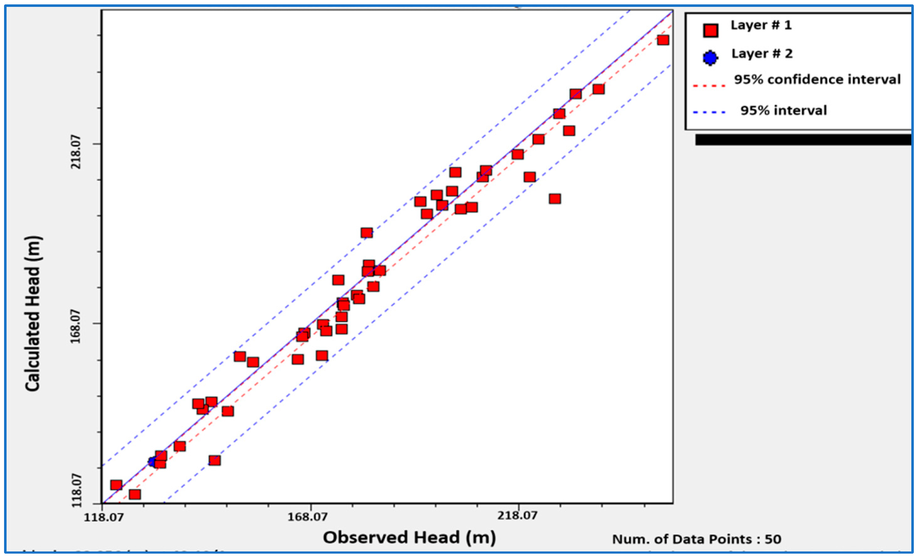
The steady-state conditions demonstrate a natural balance between the input and output parameters of the system. The steady-state calibration for the groundwater flow model of Rechna Doab is achieved by associating the hydraulic heads from contour maps with the calculated values of the MODFLOW simulation. The absolute root mean square value further confirmed this calibration value, absolute residual mean, normalized root mean square and normalized residual mean by correlating observed and calculated heads (Figure 3). Residual mean and root mean square (RMS) were calculated by the following equations:
Sum   of   residuals =   i = 1 n W i | h i H i |                  
Root   Mean   Square = 1 n i = 1 n ( h m h s )
where hm and hs are observed and simulated hydraulic head values, respectively, while “n” represents the total number of monitoring wells. Small values of RS and RMS indicate that model calibration in a steady-state condition satisfies the results. A total of 50 observations were considered, and their results revealed a valid comparison showing the model’s efficacy under field conditions [42] (Table 1).
The estimation of hydraulic conductivity was achieved by multiple measurements through pumping tests. Dupuit–Thiam equation (under steady-state conditions) was also used to calculate the hydraulic conductivity from acquired transmissivity values. Recharge is considered the major calibration parameter during model development. Flow dynamics of the study area were identified by steady-state flow simulations. After, the simulation of water elevation maps, flow velocity maps, modeled heads and water balance components were calculated (Figure 5).
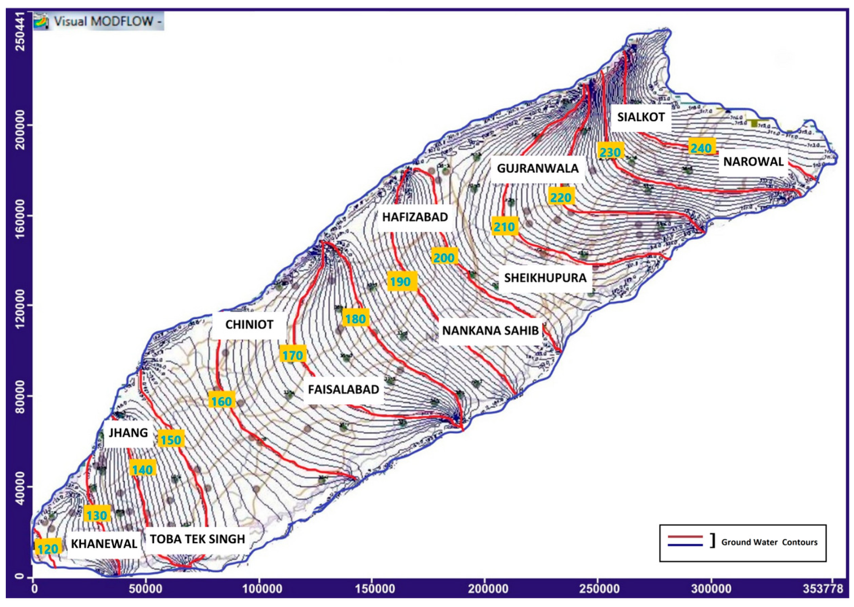
The MODFLOW®-generated groundwater contours depict that water level elevation in the Rechna Doab area ranges between 120 and 250 m, which is in agreement with the field conditions. The water level elevation decreased from northeast to southwest of Rechna Doab; the lowest water level was observed in the Khanewal district and the highest in the Sialkot region. The contours array further reflects that the link canals and the main canals are major contributing sources to the groundwater recharge. The impact of recharge from surface water channels can be observed by a downward curvature of the contours (Figure 6).
Similar to how recharge parameters can be changed to control the quantity of recharge to the groundwater system during calibration, evapotranspiration parameters can also be changed to control the rate of evapotranspiration. Extinction depth is a typical parameter that can be adjusted; it depends on the distribution of soil types in the area. Although it introduces possible flaws, this method offers a geographical and temporal estimate of the pumping.

3.2. Groundwater Velocity Contour

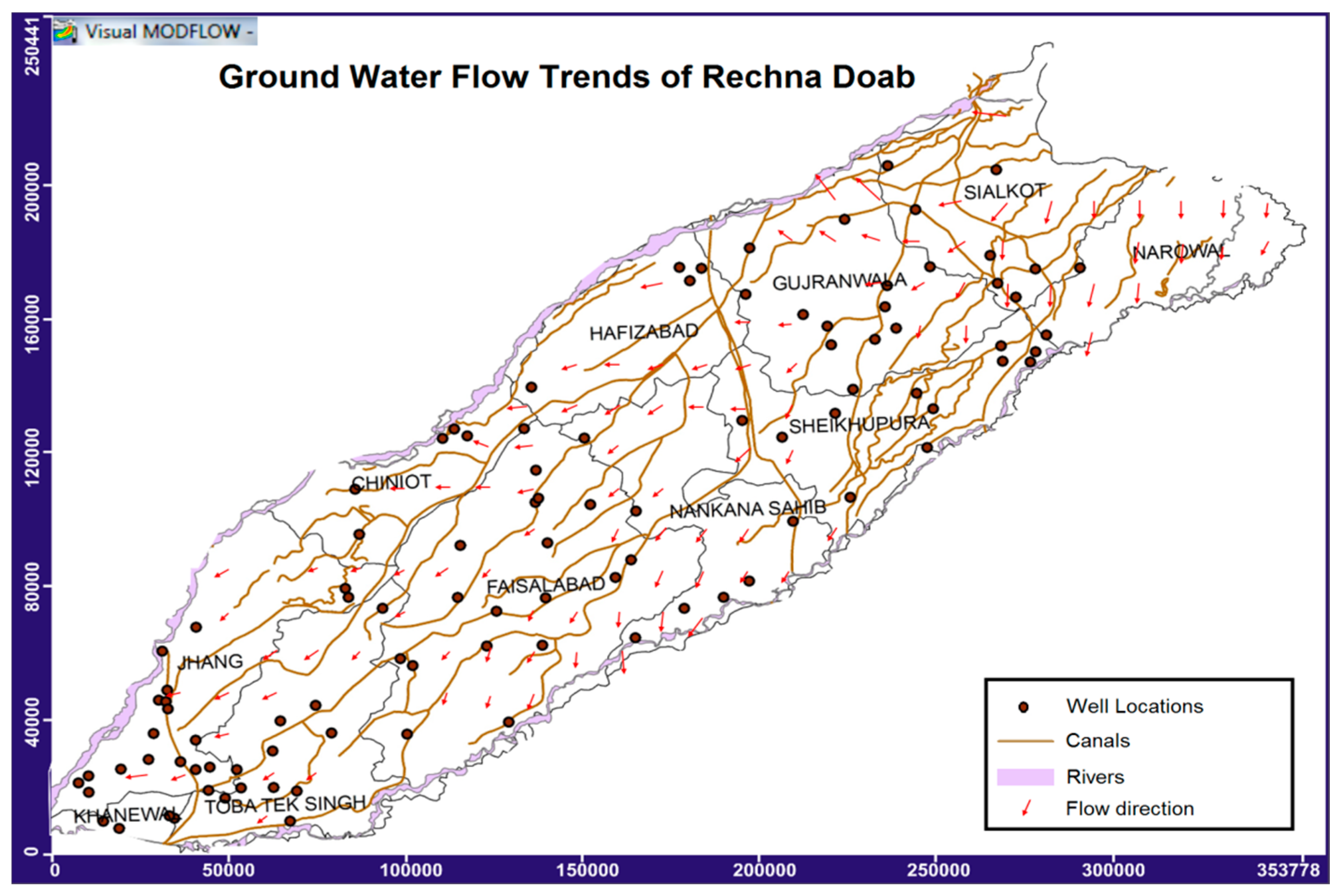
The groundwater flow generally depends on the topographic trends. As can be seen from the maps, the regional flow of water is from north to south, i.e., mostly from the area of higher elevation to a lower elevation (Figure 6 and Figure 7). The arrowheads represent the groundwater flow direction, and their lengths show the magnitude of the velocity. The groundwater flow velocities are higher in the northern part of Rechna Doab (Permeability = µ = 10−5 to 10−3) than the southern part (Permeability = µ = 10−8 to 10−6), because the hydraulic gradient drops from northern to southern direction.
Water level elevation contours are denser in northern part due to the higher hydraulic gradient. Although the overall trend of groundwater flows is from Northeastern to Southwestern in the study area, it can be varied locally as indicated in Narowal district, i.e., it flows from North to South.

3.3. Modeled Hydraulic Conductivity

The groundwater flow velocities are higher in the northern part of Rechna Doab (Permeability = µ = 10−5 to 10−3) than in the southern part (Permeability = µ = 10−8 to 10−6) because the hydraulic gradient drops from the northern to the southern direction. Water level elevation contours are denser in the northern part due to the higher hydraulic gradient. Hydraulic conductivity values for the layer-1 range between 8 m/day and 133 m/day. The majority of the southwestern parts of the area pose low horizontal conductivities. Salinity and water-logging in the southern parts have possibly suppressed the hydrological conductivities of the aquifer (Figure 8).
If the pumping from the Rechna Doab aquifer is to continue, two different but connected parts of the groundwater budget must be assessed: the distribution of pumping and the upkeep of a favorable salt balance. Fresh groundwater supplies are less accessible for irrigation from northeast to southwest or down the gradient along the doab. There is groundwater in the lower doab, but it is too salinized to be of much value for farming. Furthermore, the salinity in the doab increases with depth, which should be carefully considered.
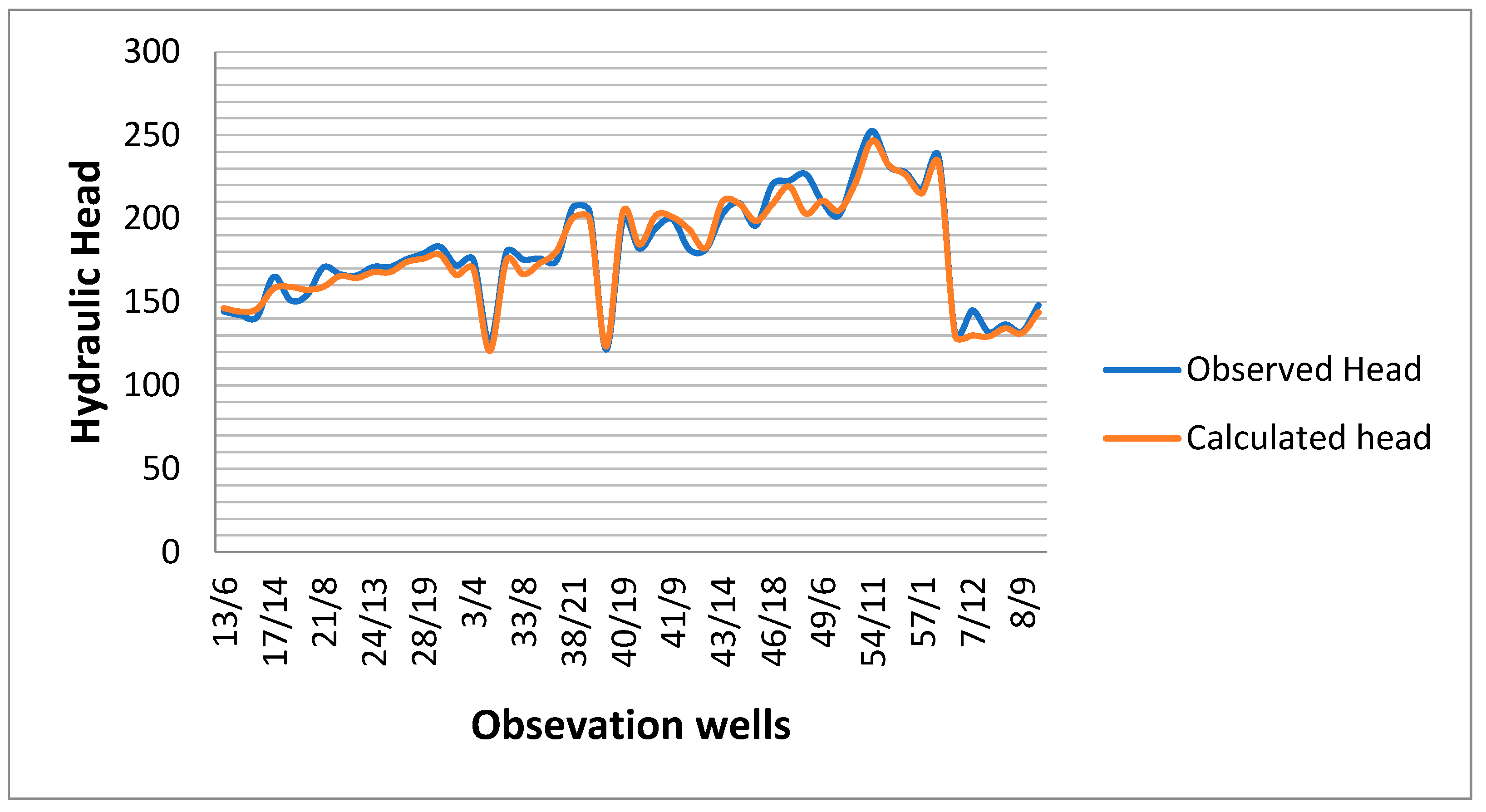
The estimation of hydraulic conductivity was achieved by multiple measurements through pumping tests. The Dupuit–Thiam equation (under steady-state conditions) was also used to calculate the hydraulic conductivity from acquired transmissivity values. Recharge is considered the major calibration parameter during model development. Flow dynamics of the study area were identified by steady-state flow simulations. After simulation, water elevation maps, flow velocity maps, modeled heads and water balance components were calculated (Figure 8). To measure the performance of the model, calibrated water levels were compared with the observed water levels of the final calibration, which reflect a close match between calculated and observed heads (Figure 9).

3.4. Sensitivity Analysis

Boundary conditions, hydraulic parameters and data from 50 observation wells were applied for model setup. Some empirical relations are established for input parameters (i.e., precipitation, evapotranspiration, canal seepage) to minimize the uncertainty in datasets used for the model input. Moreover, 20% of the average precipitation and 25% for seepage through watercourses were used for different simulations in the sensitivity analysis of the model. Based on model results, it was concluded that the model was more sensitive to hydraulic conductivity and recharge parameters.

3.5. Water Balance

Water balance results demonstrate the relative magnitude of flow components within the study area. If there is an error in model simulation, it becomes evident in the water balance. Therefore, a change in aquifer storage is always equal to the total inflow/outflow [20]. Water balance components such as storage, constant head, river leakage, evapotranspiration (ET) and recharge are calculated by MODFLOW (Figure 9, Table 2). Storage and constant head show zero inflow or outflow. On the other hand, the inflow and outflow of other water balance components are as follows: for river leakage, it is 1.066 × 10¹⁰ m3 and 5.616 × 10¹⁰ m3; it is 0 m3 and 8.386 × 10¹⁰ m3 for evapotranspiration and 5.389 × 10¹⁰ m3 and 0 m3 for the normal recharge, respectively. On the whole, the total inflow and outflow of the study area are 6.455 × 10¹⁰ m3 and 6.455 × 10¹⁰ m3, respectively (Table 2).
About 86% of the inputs to the groundwater system come from rivers and canals, making recharge and leakage the main components of the water balance. Likewise, more than 80% of all outflows come from abstractions of municipal and agricultural wells. Simulated water exactions are the function of improved pumping datasets available in the vicinity of the study area. The storage measured by the model is an indicator of less detailed monitoring information, as the screen sizes of the wells are not comprehensively available for model input. As far as the storage components of the aquifer are concerned, one more layer of detailed information is suggested. Simulated groundwater extractions indicate a moderate drawdown in the first decade.

4. Optimized Irrigation Model

4.1. Conceptualization

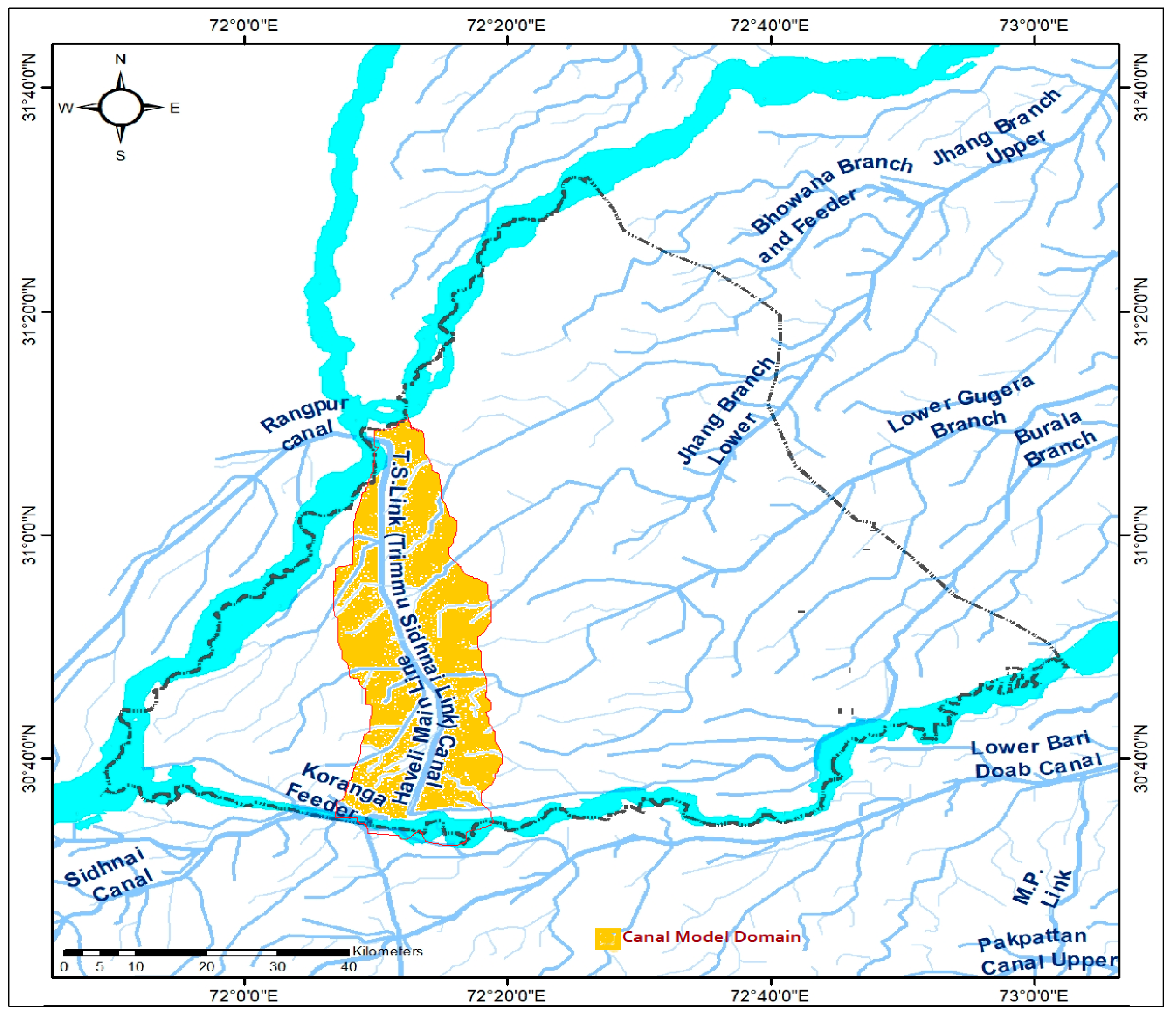
The majority of the area along the Trimmu–Sidhnai Link (TS Link) Canal shows a water table below 5 ft. that is severely water-logged. A numerical model of the waterlogged area can be handy for possible stretegies in terms of seepage estimation and land reclamation for cropping. Few of the shallow tube wells have been installed along the T-S Link canal for irrigation or water supply purposes [41] (Figure 10).
A total of 43 drainage tube wells (32 of which are of 1.5 cusec capacity and 11 of 2.5) were installed along the T-S Link and Haveli Canals to pump seepage of the canals and provide drainage relief to the adjacent areas (Figure 10). The drainage provided by these tube wells is insufficient, and additional facilities are required. The lateral Permeability of the aquifer, as determined from the pump-out tests, ranged between 0.0025 and 0.0085 ft. /sec with an average value of 0.0047 ft./s. From the reported lateral Permeability, the transmissivity of the aquifer has been estimated by multiplying the Permeability by the screen length. The estimated transmissivity ranges between 0.38 and 1.14 ft2/s with an average value equal to 0.66 ft2/s. The depths of all the test wells were between 275 and 300 ft., and the length of the well screens ranged between 120 and 155 ft. From the above, it is revealed that the upper 300 ft. aquifer of the project area and its surrounding area is highly permeable [43].

4.2. Simulated Draw Down

The drawdown of the seven observation wells poses a fluctuation of about 2–3.5 ft. in the study domain of the model. In the majority of the area, drawdown reflects values between 1.3 and 2.8 ft., while some of the areas southwest of TS-Link canal demonstrate high drawdown. In addition to the existing drain network, some drains along the said canals are proposed better efficiency of surface drainage -. The model simulations indicate the depth to water table declines in the range of 0.67 to 1.2 m (2.2 to 3.94 ft.) after one year in the affected area (Figure 11D).

4.3. Comparative Analysis Using SEEP/W

A comparative Model study using different proposed options for the T-S Link canal was carried out, keeping the same geometry and inputs (soil properties and boundary conditions) for all cases [44,45,46]. A comparison of the resulting seepage flux of various cases points out the effective solution against the seepage problem. Three different protective options considered for model analysis are as follows: (1) an additional lined channel with a 6500 cusec discharge, (2) concrete side protection with a toe wall and (3) a complete concrete lining section (Figure 11B).

4.4. Canal Water Optimization

The lining of the canal to control seepage from the Trimmu–Sidhnai Link canal is a promising remedial measure. Canal lining will reduce seepage only from the canal. All other recharge components and seepage from the main canals after lining will have to be pumped through tube wells. Therefore, 173 additional field tube wells will be installed in an area of 80,000 acres where the depth to the water table is equal to or less than 5.0 feet below the ground surface. All the installed tube wells will be 2.0 cusec in size.

5. Conclusions

The numerical flow model revealed that groundwater flow simulations in Rechna Doab are good representatives of the real groundwater flow dynamics of the study area. The water balance analysis illustrates zero inflow and outflow for storage and constant head. A negative flow is observed for river leakage and evapotranspiration, while a positive flow is identified for recharge. It is found that the return flows from the irrigation canals are significant sources of aquifer recharge. The generated contours suggest maximum groundwater depth in the northeastern parts of the irrigated drainage basin. The current model of the inter-fluvial basin demonstrates a good response to the water fluctuations prevailing in both vertical domains of the aquifer. This model can effectively be used to formulate sustainable groundwater practices in if a well-executed monitoring strategy is implemented. The hypothesis of this model can also be used for other irrigated drainage basins to understand the hydrogeological behavior of the aquifers. As far as groundwater resource management is concerned, Rechna Doab needs to be modeled for predictive scenarios. The sustainable solutions of conjunctive water management in Rechna Doab are constrained by seasonal surface-water flows, groundwater quality and climatic variability. The groundwater flow model of the basin can effectively be used with SWAT and GMS for climatic impacts on cropping patterns of the area.
A specialized bi-layered flow model coupled with SEEP/W for the Trimmu–Sidhnai canal (T-S canal) suggests a declining water table trend of 2 to 4 ft. if the restoration of existing and additional surface drains is provided. Water table simulations reflect that 35,000 (43%) acres of water-logged land will be relieved for normal cropping. The flow model output designates that the water-logging problem in the vicinity of the Trimmu–Sidhnai canal (T-S canal) can reasonably be reduced.

Author Contributions

Conceptualization, M.S. and S.R.A.; methodology, M.S. and S.R.A.; software, M.S.; validation, M.K.; formal analysis, M.S. and K.M.; resources, S.R.A. and X.W.; data curation, M.S., X.W. and M.Q.M.; writing—original draft preparation, M.S; writing—review and editing, X.W.; visualization, M.S.; supervision, S.R.A., K.M. and X.W.; project administration, S.R.A. and K.M. All authors have read and agreed to the published version of the manuscript.

Funding

This research received no external funding.

Data Availability Statement

Data is contained within the article.

Acknowledgments

Muhammad Sanaullah, the principal author, greatly acknowledges the financial support of the University of Punjab for Ph.D. research work and the facilities provided by A.D. Khan, The Director General Pakistan Council of Research in Water Resources (PCRWR), Islamabad, for his valuable contribution during this study.

Conflicts of Interest

The authors declare no conflict of interest.

References

  1. Zheng, C.; Wang, P.P. MT3DMS: A Modular Three-Dimensional Multispecies Transport Model for Simulation of Advection, Dispersion and Chemical Reactions of Contaminants in Groundwater Systems. In Documentation and User’s Guide; Contract Report SERDP-99-1; US Army Corps of Engineers-Engineer Research and Development Center: Vicksburg, MS, USA, 1999. [Google Scholar]
  2. Domenico, P.A.; Schwartz, F.W. Physical and Chemical Hydrogeology; John Wiley & Sons: Hoboken, NJ, USA, 1998. [Google Scholar]
  3. McDonald, M.G.; Harbaugh, A.W. A Modular Three-Dimensional Finite-Difference Ground-Water Flow Model; US Geological Survey: Reston, VA, USA, 1988.
  4. Kinzelbach, W. Applied groundwater modeling—simulation of flow and advective transport. J. Hydrol. 1992, 140, 393–394. [Google Scholar] [CrossRef]
  5. Mercer, J. Applied groundwater modeling: Simulation to flow and advective transport. J. Contam. Hydrol. 1992, 10, 339–340. [Google Scholar] [CrossRef]
  6. Harbaugh, A.W. MODFLOW-2005, the US Geological Survey Modular Ground-Water Model: The Ground-Water Flow Process; US Department of the Interior, US Geological Survey: Reston, VA, USA, 2005; Volume 6. [CrossRef]
  7. Zhu, J.; Wang, Y.; Guo, H.; Zang, X.; Qin, T. Application of groundwater model to groundwater regulation in cangzhou area. E3s Web Conf. 2019, 79, 03014. [Google Scholar] [CrossRef]
  8. Harbaugh, A.W.; Banta, E.R.; Hill, M.C.; Mcdonald, M.G. MODFLOW-2000, the U.S. Geological Survey Modular Ground-Water Model-User Guide to Modularization Concepts and the Ground-Water Flow Process; Open-File Report; U.S. Geological Survey: Reston, VA, USA, 2000; p. 134.
  9. Wang, S.; Shao, J.; Song, X.; Zhang, Y.; Huo, Z.; Zhou, X. Application of MODFLOW and geographic information system to groundwater flow simulation in North China Plain, China. Environ. Geol. 2008, 55, 1449–1462. [Google Scholar] [CrossRef]
  10. Bailey, R.; Wible, T.; Arabi, M.; Records, R.; Ditty, J. Assessing regional-scale spatio-temporal patterns of groundwater–surface water interactions using a coupled swat-modflow model. Hydrol. Process. 2016, 30, 4420–4433. [Google Scholar] [CrossRef]
  11. Yifru, B.; Chung, I.; Kim, M.; Chang, S. Assessment of groundwater recharge in agro-urban watersheds using integrated swat-modflow model. Sustainability 2020, 12, 6593. [Google Scholar] [CrossRef]
  12. Bouaamlat, I.; Larabi, A.; Faouzi, M. Hydrogeological investigation of an oasis-system aquifer in arid southeastern Morocco by development of a groundwater flow model. Hydrogeol. J. 2016, 24, 1479. [Google Scholar] [CrossRef]
  13. Gebreyohannes, T.; De Smedt, F.; Walraevens, K.; Gebresilassie, S.; Hussien, A.; Hagos, M.; Amare, M.; Deckers, J.; Gebrehiwot, K. Regional groundwater flow modeling of the Geba basin, northern Ethiopia. Hydrogeol. J. 2017, 25, 639. [Google Scholar] [CrossRef]
  14. Ochoa, C.; Sierra, A.; Vives, L.; Zimmermann, E.; Bailey, R. Spatio-temporal patterns of the interaction between groundwater and surface water in plains. Hydrol. Process. 2020, 34, 1371–1392. [Google Scholar] [CrossRef]
  15. Yihdego, Y.; Reta, G.; Becht, R. Hydrological analysis as a technical tool to support strategic and economic development: A case study of lake navaisha, kenya. Water Environ. J. 2016, 30, 40–48. [Google Scholar] [CrossRef]
  16. Latif, M.; Tariq, J.A. Performance assessment of irrigation management transfer from government-managed to farmer-managed irrigation system: A case study. Irrig. Drain. 2009, 58, 275–286. [Google Scholar] [CrossRef]
  17. Siddiqui, I.H. Irrigation Canals: Planning, Design, Construction, and Maintenance; National Book Foundation: Islamabad, Pakistan, 1979. [Google Scholar]
  18. Deng, C.; Bailey, R.T. Assessing the Impact of Artificial Recharge Ponds on Hydrological Fluxes in an Irrigated Stream–Aquifer System. Hydrology 2022, 9, 91. [Google Scholar] [CrossRef]
  19. Ahmad, M.D. Estimation of Net Groundwater Use in Irrigated River Basins Using Geo-Information Techniques: A Case Study in Rechna Doab, Pakistan. Ph.D. Thesis, Wageningen University, Wageningen, The Netherlands, 2002. [Google Scholar]
  20. Khan, S.; Rana, T.; Gabriel, H.; Ullah, M.K. Hydrogeologic assessment of escalating groundwater exploitation in the Indus Basin, Pakistan. Hydrogeol. J. 2008, 16, 1635–1654. [Google Scholar] [CrossRef]
  21. Jehangir, W.A.; Qureshi, A.S.; Ali, N. Conjunctive Water Management in the Rechna Doab: An Overview of Resources and Issues; International Water Management Institute (IWMI): Lahore, Pakistan, 2002; Volume 48. [Google Scholar]
  22. Arslan, M.; Tauseef, M.; Gull, M.; Baqir, M.; Ahmad, I.; Ashraf, U.; Al-Tawabini, B.S. Unusual rainfall shift during monsoon period of 2010 in Pakistan: Flash flooding in Northern Pakistan and riverine flooding in Southern Pakistan. Afr. J. Environ. Sci. Technol. 2013, 7, 882–890. [Google Scholar]
  23. Khalid, P.; Sanaullah, M.; Sardar, M.J.; Iman, S. Estimating active storage of groundwater quality zones in alluvialdeposits of Faisalabad area, Rechna Doab, Pakistan. Arab. J. Geosci. 2019, 12, 206. [Google Scholar] [CrossRef]
  24. Anjum, W.A.; Ahmad, S.R.; Sanaullah, M.; Majid, Z.; Mirza, K. Geographic Information System and Modelling Approach for Groundwater Systems of Rechna Doab, Pakistan. Pak. J. Sci. 2016, 68, 470–476. [Google Scholar]
  25. Ashraf, A. The Conjunctive Use of Groundwater Modelling and Geographic Information System (GIS) to Study the Water Resources of Upper Jhelum Scarp Area in Indus Basin. Ph.D. Thesis, Quaid-i-Azam University, Islamabad, Pakistan, 2008. [Google Scholar]
  26. Lachaal, F.; Mlayah, A.; Bédir, M.; Tarhouni, J.; Leduc, C. Implementation of a 3-D groundwater flow model in a semi-arid region using MODFLOW and GIS tools: The Zéramdine–Béni Hassen Miocene aquifer system (east-central Tunisia). Comput. Geosci. 2012, 48, 187–198. [Google Scholar] [CrossRef]
  27. Yang, Q.; Lun, W.; Fang, Y. Numerical modelling of three-dimensional groundwater flow in Tongliao (China). Procedia Eng. 2011, 24, 638–642. [Google Scholar] [CrossRef]
  28. Dong, Y.; Li, G.; Xu, H. An areal recharge and discharge simulating method for MODFLOW. Comput. Geosci. 2011, 42, 203–220. [Google Scholar] [CrossRef]
  29. Manghi, F.; Williams, D.; Safely, J.; Hamdi, M.R. Groundwater flow modelling of the Arlington basin to evaluate management strategies for expansion of the Arlington desalter water production. Water Resour. Manag. 2012, 26, 21–41. [Google Scholar] [CrossRef]
  30. Sedki, A.; Ouazar, D. Simulation-optimization modelling for sustainable groundwater development: A Moroccan coastal aquifer case study. Water Resour. Manag. 2011, 25, 2855–2875. [Google Scholar] [CrossRef]
  31. Xu, X.; Huang, G.; Qu, Z.; Pereira, L.S. Using MODFLOW and GIS to assess changes in groundwater dynamics in response to water saving measures in irrigation districts of the Upper Yellow River Basin. Water Resour. Manag. 2011, 25, 2035–2059. [Google Scholar] [CrossRef]
  32. Ngenzebuhoro, P.C.; Dassargues, A.; Bahaj, T.; Orban, P.; Kacimi, I.; Nahimana, L. Groundwater Flow Modeling: A Case Study of the Lower Rusizi Alluvial Plain Aquifer, North-Western Burundi. Water 2021, 13, 3376. [Google Scholar] [CrossRef]
  33. Awais, M.; Arshad, M.; Ahmad, S.R.; Nazeer, A.; Waqas, M.M.; Aziz, R.; Shakoor, A.; Rizwan, M.; Chauhdary, J.N.; Mehmood, Q. Simulation of Groundwater Flow Dynamics under Different Stresses Using MODFLOW in Rechna Doab, Pakistan. Sustainability 2023, 15, 661. [Google Scholar] [CrossRef]
  34. Anderson, M.P.; Woessner, W.W.; Hunt, R.J. Applied Groundwater Modelling: Simulation of Flow and Advective Transport; Academic Press: Cambridge, MA, USA, 2015. [Google Scholar]
  35. Mundorff, M.J.; Carrigan, P., Jr.; Steele, T.; Randall, A. Hydrologic Evaluation of Salinity Control and Reclamation Projects in the Indus Plain, Pakistan—A Summary; U.S. Government Publishing Office: Washington, DC, USA, 1976.
  36. Barnett, B. Australian Groundwater Modelling Guidelines; National Water Commission: Canberra, Australia, 2012; Volume 82, pp. 11–42. [Google Scholar]
  37. Rehman, G.; Jehangir, W.; Rehman, A.; Aslam, M.; Skogerboe, G. Principal Findings and Implications for Sustainable Irrigated Agriculture: Salinity Management Alternatives for the Rechna Doab, Punjab Pakistan, Volume I; Research Report No. R-21.1; International Irrigation Management Institute, International Irrigation Management Institute L.: Lahore, Pakistan, 1997; pp. 24–52. [Google Scholar]
  38. Lautz, L.K.; Siegel, D.I. Modelling surface and groundwater mixing in the hyporheic zone using MODFLOW and MT3D. Adv. Water Resour. 2006, 29, 1618–1633. [Google Scholar] [CrossRef]
  39. Aslam, M.; Arshad, M.; Singh, V.P.; Shahid, M.A. Hydrological Modeling of Aquifer’s Recharge and Discharge Potential by Coupling WetSpass and MODFLOW for the Chaj Doab, Pakistan. Sustainability 2022, 14, 4421. [Google Scholar] [CrossRef]
  40. PPSGDP. Punjab Private Sector Groundwater Development Project: Database for Groundwater Management in Kamalia-Pir Mehal Area of LCC Command Area in Rechna Doab; Technical report; Department IaP: Punjab, Pakistan, 1999; p. 37. [Google Scholar]
  41. Khan, S.; Rana, T.; Ullah, K.; Christen, E.; Nafees, M. Investigating Conjunctive Water Management Options Using a Dynamic Surface-Groundwater Modelling Approach: A Case Study of Rechna Doab; CSIRO Technical Report 35/03; CSIRO: Canberra, Australia, 2003. [Google Scholar]
  42. Aghlmand, R.; Abbasi, A. Application of MODFLOW with Boundary Conditions Analyses Based on Limited Available Observations: A Case Study of Birjand Plain in East Iran. Water 2019, 11, 1904. [Google Scholar] [CrossRef]
  43. Kijne, J.W. Water and Salinity Balances for Irrigated Agriculture in Pakistan; Research Report 6; IWMI: Colombo, Sri Lanka, 1996. [Google Scholar]
  44. Aribudiman, I.N.; Redana, I.W.; Harmayani, K.D.; Ciawi, Y. Seepage in soil from the difference of water viscosity using Geo-studio SEEP/W program. Int. Res. J. Eng. IT Sci. Res. 2019, 5, 15–26. [Google Scholar] [CrossRef]
  45. Gabriel, H.F. An Appraisal of Climate Urban Groundwater Management Options in a Stressed Aquifer System. Ph.D. Thesis, International Centre of Water for Food Security, School of Environmental Sciences, Faculty of Science, Charles Sturt University, Wagga, Australia, 2010. [Google Scholar]
  46. Punthakey, J.; RKhan, M.; Riaz, M.W.; Javed, M.; Zakir, G.; Usman, M.; Amin, M.; Niaz Ahmad, R.; Blackwell, J.; Culas, R.; et al. Assessment of Groundwater Resources for Rechna Doab, Pakistan: Final Report; Australian Centre for International Agricultural Research (ACIAR): Canberra, Australia, 2015.
Figure 1. Hydrological framework of the study area.
Water 15 04193 g001
Figure 2. The spatial domain of the aquifer represented in the model consists of multiple layer setups.
Water 15 04193 g002
Figure 3. Model input parameters: (A) evapotranspiration and (B) groundwater abstractions.
Water 15 04193 g003
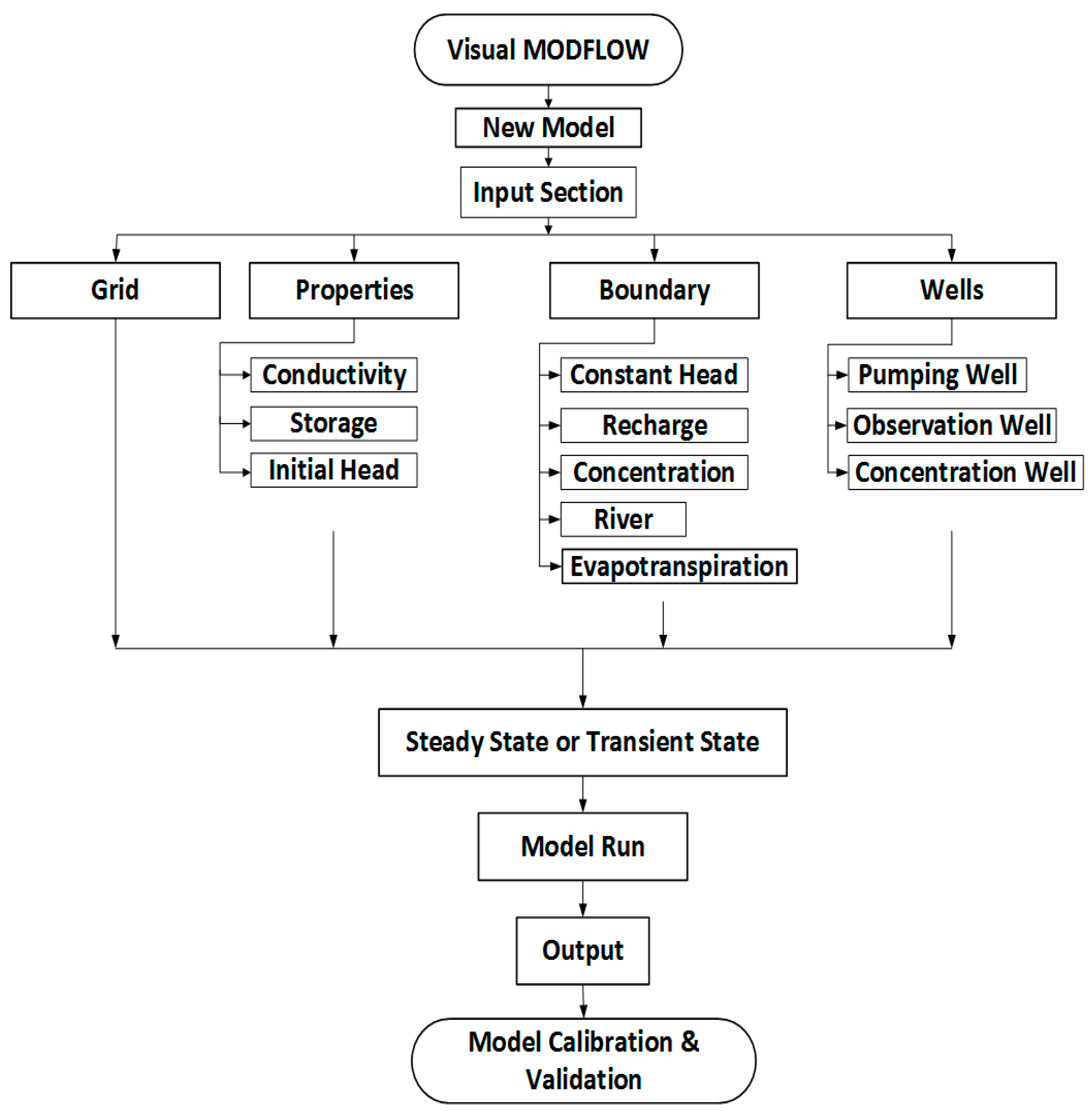
Figure 4. Flowchart of groundwater flow model generation using MODFLOW.
Water 15 04193 g004
Figure 5. Computed versus observed head for steady state water level contours.
Water 15 04193 g005
Figure 6. Water level contours of Rechna Doab (Model Generated).
Water 15 04193 g006
Figure 7. Groundwater flow trends of Rechna Doab.
Water 15 04193 g007
Figure 8. Simulated horizontal hydraulic conductivity.
Water 15 04193 g008
Figure 9. Comparison of observed and simulated hydraulic head.
Water 15 04193 g009
Figure 10. Location map of irrigation optimization model.
Water 15 04193 g010
Figure 11. (A) Calibration curves of output parameters (B) Canal seepage (C) Calibration residuals and (D) Simulated drawdown.
Water 15 04193 g011
Table 1. Model calibration statistics.
Max. Residual−23.856 m at 19–48A
Min. Residual0.367 m at 8–54A
Residual Mean−1.924 (m)
Abs. Residual Mean4.762 (m)
No. of data points50
Root Mean square6.394 (m)
Normalized RMS4.877 (%)
Correlation factor0.982
Table 2. Water balance components.
Sr. NoWater Balance ComponentsIn (Volume m3)Out (Volume m3)
1Storage00
2Constant Head00
3River Leakage1.066 × 10105.616 × 1010
4Evapotranspiration08.386 × 109
5Recharge5.389 × 10100
Total6.455 × 10106.455 × 1010
Disclaimer/Publisher’s Note: The statements, opinions and data contained in all publications are solely those of the individual author(s) and contributor(s) and not of MDPI and/or the editor(s). MDPI and/or the editor(s) disclaim responsibility for any injury to people or property resulting from any ideas, methods, instructions or products referred to in the content.