Article

Evolutionary Trends and Coordinated Development Analysis of Water Resources Systems and High-Quality Economic Growth in the Yangtze River Delta

1
Institute of Finance and Economics/School of Urban and Regional Sciences, Shanghai University of Finance and Economics, Shanghai 200433, China
2
School of Economics and Management, Shanghai University of Electric Power, Shanghai 200090, China
3
School of Economics and Management, Shanghai University of Political Science and Law, Shanghai 201701, China
*
Author to whom correspondence should be addressed.
These authors contributed equally to this work.
Water 2023, 15(22), 4030; https://doi.org/10.3390/w15224030
Submission received: 18 September 2023 / Revised: 17 November 2023 / Accepted: 18 November 2023 / Published: 20 November 2023
(This article belongs to the Special Issue Reservoir Control Operation and Water Resources Management)

Abstract

:
This article calculates the indices for high-quality economic development and water resource systems across 25 cities in the Yangtze River Delta from 2011 to 2021. Utilizing a multifaceted analytical framework comprising the CRITIC method, standard deviation ellipse, harmonious development coefficient, and coupling coordination coefficient, we investigate spatiotemporal evolutionary trends and overarching harmonious development states between the two systems. Results indicate: (1) Throughout the research period, mean values of high-quality economic development indices fluctuated within the range of 0.05 to 0.68, while water resource carrying capacity indices oscillated between 0.18 and 0.81. (2) The epicenter of high-quality economic development indices is situated in the periphery of Lake Tai, whereas the fulcrum of the water resource system indices is located in Huzhou City, both displaying a northwest-southeast orientation. (3) Coupling coordination development exhibits a propitious advancement trajectory, with certain locales attaining exemplary coordinated growth.

1. Introduction

The issue of high-quality economic development and the developmental trends in water resource carrying capacity is a comprehensive issue, which is included in the process of researching the sustainable development path of society–economy–resources–environment. Amidst the acceleration towards an epoch characterized by high-quality economic expansion, harmonizing the relationship between water resource utilization efficacy and superior economic growth becomes an exigent quandary warranting immediate redress. The 2018 Yangtze River Delta Leadership Roundtable emphasized “Focusing on Quality, Fostering Integration” as its thematic cornerstone, delineating the blueprint for integrated high-quality development in the region. Serving as a pivotal strategic overlay within the Delta, the Yangtze River Delta is primed not only to advance its own elevated economic development but also to actuate industrial transference and diffusion to the surrounding area, thereby engendering high-quality growth in neighboring provinces. The National Development and Reform Commission, in its “Socioeconomic Development Report” in 2017 and 2018, explicitly underscores the imperative for high-quality development to engender a resource-efficient and ecologically benign development architecture. To carve out a focal zone of exceptional economic development within the Yangtze River Delta, there is a compelling necessity to pivot away from an unsustainable growth model predicated upon high input, consumption, and pollution, towards augmenting the efficiency of input factors. Policy documents such as the “Yangtze River Delta Regional Integration Development Plan” and the “Yangtze River Delta Ecological Green Integrated Development Demonstration Zone Overall Plan” advocate the pre-emptive transmutation of ecological assets into socio-economic developmental advantages. Currently, the water demand in the Yangtze River Delta region is increasing, while the increasingly severe water shortage and water environment degradation problems are seriously constraining the sustainable development of the regional industrial economy. At the same time, the uneven allocation of water resources in the region leads to the low economic value of water resources, and the utilization of water resource flow capital and stock capital, as the core of the three-dimensional water resource ecological footprint model, are closely related to economic development. The Yangtze River Delta, as the first urban agglomeration in China, is a strategic area for China’s economic development and also a sensitive area for environmental protection, and the coordination between its economy and environment is particularly important, and it is significant to explore the coordination relationship between the economy and the environment based on the perspective of a large watershed in the evolution of spatial and temporal patterns.
With the advancement of urbanization, the traditional provincial and administrative economies are changing to urban agglomerations, which are important for promoting regional economic development and water resource management. Therefore, it is urgent to analyze the correlation between water resources and economic development at the scale of urban agglomerations, so as to reveal the efficiency of water resource use and the impact of economic development on the sustainable use of water resources. The correlation between water resources and economic development at the scale of urban agglomerations is therefore urgent. Therefore, our manuscript concurrently calculates indices for high-quality economic development and water resource systems, employing coupling coefficients and standard deviation ellipses to gauge the spatio-temporal distribution and centroidal dispersion of high-quality economic development and water resource systems, respectively. It delves into their spatial evolutionary trends within the period under investigation and calculates their degree of coordinated development (coupled coordination and elliptic difference models). The assessment is undertaken from both spatiotemporal matching trends and quantitative synergy perspectives, aiming to elucidate the operative mechanisms under various states of coordination. This serves as a foundational reference for enhancing water resource utilization efficiency, expediting high-quality economic advancement, and facilitating the amelioration of urban aquatic environments, thereby mitigating the inherent contradictions within the water resource high-quality economic development system to achieve sustainable progress in both domains.

2. Literature Overview

Presently, scholars both domestically and internationally have embarked on extensive research endeavors to examine the intricate interrelationship between water resources and economic development, yielding a myriad of significant findings. International research concerning the nexus between economy and environment commenced in the mid-20th century [1,2,3], concentrating primarily on an array of focal points such as the societal and economic ramifications on water resource demand and impact, and the role and limitations of water resources in the progression of urbanization, as well as the implications of water resources provision on economic proliferation [1,2,3,4,5,6,7,8]. Ren et al. [9] established a system dynamics model of water resources, water environment, and water ecological carrying capacity, and explored the relationship between water resources and ecology in the Wulansu Sea by simulating five scenarios. Luo et al. [10] constructed an economic–water–ecological framework and established a harmonious regulation model to explore the degree of harmonious development in the Shaying River Basin. The research about China in this realm originated in the 1970s, with environmental economics serving as the theoretical cornerstone. A large number of studies [11,12,13,14] have led to a rich discussion around the existence of environmental Kuznets curves. These studies have pointed out that achieving harmonious and sustainable development of the economy and the environment is key to the social stability of countries. Given the complexities of demographic structure, economic systems, and disparate resource allocation, Chinese scholars [15,16,17] have undertaken rigorous analyses of water resources and economic growth. Situating urban development as the backdrop for research, multifarious methodologies such as Fuzzy Set Theory, Multi-objective Models of Aquatic Ecological Carrying Capacity, and Semi-Γ Distribution Indices based on Particle Swarm Optimization have been employed to scrutinize varying scales, including urban water bodies, metropolitan clusters, catchment areas, and provincial domains, in locations such as the Henan Province, East Lake in Wuhan, Changsha-Zhuzhou-Xiangtan Urban Agglomeration, Yangtze River Delta Catchment, and Jiangsu Province. These studies [18,19,20] aim to evaluate the water environment’s carrying capacity, the responsiveness of urban clusters to water resources, water level fluctuations, and the carrying capacity of urban water resources, in an endeavor to elucidate sustainable models for water resource management. Furthermore, treating economic development and water resources as discrete yet interrelated systems for coupled research constitutes another investigative modality for deciphering their mutual interplay [21,22]. Zhang et al. [23] used the four major river basins in the Henan Province as the research scale, and analyzed the evolution of the coupled coordination degree of water resources use and economic and social development by using the coupled coordination degree model and gray prediction method.
In summary, research focusing individually on water resources and economic development is relatively prevalent, encompassing theoretical frameworks, evaluative assessments of developmental phases, and case studies. The methodologies employed range from conventional trend analysis to computationally intensive techniques based on the Environmental System of Equations Framework (ESEF), system dynamics models, and neural network-based models of water resource carrying capacity [24,25,26]. However, current studies that consider both elements predominantly scrutinize the development of one aspect through the lens of the other, and there is a notable lack of comprehensive exploration of the mechanisms of their interaction, synergistic growth, and influencing factors. Thus, it becomes challenging to holistically appraise their regional compatibility and specific impact mechanisms. Our marginal contribution lies in the fact that the study is based on the Yangtze River Delta urban agglomeration, which has the most developed water resource system and economic development system, and the study of the coupling of resources and economy in this region can help other regions and urban agglomerations in China to explore new development paths. Secondly, the CRITIC methodology is used to measure the high-quality development of the water resource system and economy, to rationally judge the current development status of each city from the perspective of objective empowerment, and to help the government to formulate the direction of local green development.

3. Overview of the Research Region

The Yangtze River Delta, situated at the downstream confluence of the Yangtze River, flanked by the Yellow Sea and the East China Sea, constitutes an ecotone characterized by a maritime–terrestrial interface. Comprising two provinces, Jiangsu and Zhejiang, along with the municipality of Shanghai, the region spans an expansive geographical expanse of approximately 219,000 square kilometers. The climatic conditions predominantly exhibit subtropical monsoonal characteristics, with elevated warming rates primarily observed during the winter and spring months, and a relative attenuation during the summer. Trends in temperature fluctuations, warming rates, and the contributions to warming from urbanization effects exhibit a commendable congruence with those of other regions. Hydrologically, the Yangtze River Delta boasts an intricate network of water bodies, featuring prominent lakes such as Taihu, Hongze, and Jinniu in Jiangsu, and Xihu, Donghu, and Qiandao in Zhejiang. In addition to significant rivers like the Yangtze, Qiantang, and the Grand Canal, the area is also replete with other noteworthy waterways such as Shanghai’s Huangpu and Wusong rivers, Jiangsu’s Qinhuai and Xinshu rivers, and Zhejiang’s Oujiang and Lingjiang rivers. The region is further enriched by a plethora of lacustrine resources, riparian zones, and wetlands. These aquatic resources play an indispensable role in sustaining agricultural irrigation and industrial development within the Yangtze River Delta milieu.
The Yangtze River Delta, centered on Shanghai and radiating to the surrounding cities, has become one of the most dynamic and economically developed regions in the world’s major urban agglomerations. In 2022, Jiangsu’s GDP exceeded the 12 trillion-yuan mark and its economic scale stepped up to a new level, while Zhejiang’s GDP exceeded 7.5 trillion yuan and Shanghai’s GDP exceeded 4 trillion yuan. Based on the country’s economic policies and as a region created by the state to become rich first, the Yangtze River Delta has achieved remarkable economic results and provided a good model for China’s economic development. In recent years, under the guidance of the country’s new development philosophy, the economic development of the Yangtze River Delta region has also turned to green, environmental protection, and sustainability.

4. Indicator Framework and Research Methodology

Indicator Framework

In alignment with the unique attributes of the Yangtze River Delta, we provisionally select an evaluative index system to gauge the levels of high-quality economic development and water resource systems. Utilizing the CRITIC method, we ascertain the weights of these indices. After determining the weights, we labeled the attributes in Table 1 with reference to existing studies and the relevance of each indicator. The “+” represents that the indicator layer will have a positive impact on the target layer and the “−” represents that the indicator layer will have a negative impact on the target layer. The water resource system encompasses three dimensions, namely water resource availability, utilization, and conservation, and includes a total of seven indicators. On the other hand, high-quality economic development is segmented into four dimensions: industrial structure, technological innovation, ecological environment, and standard of living, comprising a total of nine indicators. Within this, the index of industrial advancement is calculated based on the ratio of the output value of tertiary to secondary sectors. The rationalization of the industrial structure is assessed by drawing upon methodologies proposed by Deng Huihui et al. [27]. Given the data paucity regarding the output value of the productive service sector in most cities, the proportion of employment in productive service industries (productive services industries mainly include R&D, design and other technical services for production activities, cargo transportation, general aviation production, warehousing and postal courier services, information services, financial services, energy-saving and environmental protection services, productive leasing services, business services, human resource management and vocational education and training services, wholesale and trade brokerage and agency services, and productive support services) is adopted as a surrogate metric.

5. Research Methodology

5.1. Refinement of the CRITIC Method

In the selection of water resource system evaluation models and methods, representative research methods mainly include subjective empowerment methods such as principal component analysis [28], the fuzzy comprehensive evaluation method [29] and objective empowerment methods such as the BP neural network [30], data envelopment analysis method [31] and Topsis [32]. Subjective empowerment is subject to human influence, so we choose the objective empowerment method. The CRITIC (Criteria Importance Through Inter-criteria Correlation) methodology, originally postulated by Diakoulaki (1995), serves as an objective algorithm for attribute weighting. This method harnesses the differential attributes and inter-criterion discordances to reflect the informational content and distinctiveness of each criterion, consequently establishing their respective weights. Variability is for the differences in the magnitude of the values of the same indicator among different samples, which is determined by the standard deviation of each indicator, and the standard deviation is calculated for each column after preprocessing. The size and direction of conflict is expressed by the correlation coefficient, which can be expressed as i = 1 n ( 1 r i j ) , where r i j is the correlation coefficient between the jth indicator and the ith indicator, and it also indicates that for the positive correlation and the negative correlation which have the same absolute value, the conflict between the indicators is the same. If two indicators have a strong positive correlation, it means that their conflictability is low. The weight of the indicator is calculated according to the difference and conflict of the indicator, and let C j be the amount of information contained in the jth indicator, and the weight of indicator j is the proportion of the information C j (i.e., the product of the difference and conflict) contained in indicator j to the proportion of all of the information, which is expressed as follows:
C j = σ j x ¯ i = 1 n ( 1 r i j )       j   =   1 ,   2 ,   ,   n
where a larger C j signifies a higher informational content and correspondingly a greater weight for the j criterion.
W j = C j i = 1 n ( C j )         j = 1,2 , , n

5.2. Coupling Coordination Model

The Coupling Coordination Model delineates the degree of mutual influence and synergistic advancement between two or more interconnected systems, thereby capturing the equilibrium state of water resource utilization in concert with high-quality economic development. The computational formula is as follows.
C = f ( x ) × f ( y ) f x + f y 2 2
T = α f x + β f ( y )
D = C × T
where D represents the coupling coordination degree, C signifies the coupling correlation degree, and T denotes the comprehensive evaluation index. f ( x ) and f ( y ) are evaluative values for high-quality economic development and water resource systems, respectively. The variables α and β manifest the relative contributions of high-quality economic development and water resource utilization. We also used the CRITIC method to assign weights and calculate the standard deviation and correlation of the indicators, obtaining α   = 0.484 and β = 0.516. Drawing upon extant research findings [33], the phase and type of synergistic development between water resource utilization and high-quality economic development in the Yangtze River Delta are articulated in Table 2.

5.3. Relative Development Model

While the Coupling Coordination Model elucidates the degree of synchronized advancement between high-quality economic growth and water resources, it falls short of quantifying the developmental disparity between the two entities. Consequently, the relative development index is introduced to delineate the level of either accelerated or lagging development between them. The mathematical representation for the relative development index is as follows.
P = f ( x ) f ( y )
In this equation, P denotes the relative development index. When P > 1.2, it signifies that the regional high-quality economic growth is in a state of accelerated development. If 0.8 < P ≤ 1.2, it indicates that high-quality economic growth and water resources are advancing in synchrony. Should P ≤ 0.8, it portrays the regional high-quality economic growth as lagging.

5.4. Standard Deviation Ellipse Model

The standard deviation ellipse model falls under the purview of spatial pattern statistical analysis, focusing predominantly on explicating the global characteristics of geographical feature distributions. The precise computational formulae for the parameters of the standard deviation ellipse are delineated as follows.
x = x i x a v e ; y = y i y a v e
t a n θ = i = 1 n W i 2 x i 2 i = 1 n W i 2 y i 2 + i = 1 n W i 2 x i y i i = 1 n W i 2 y i 2 + 4 ( i = 1 n W i 2 x i y i ) 2 i = 1 n W i 2 x i 2 y i 2
δ x = i = 1 n ( W i x i c o s θ W i y i s i n θ ) 2 i = 1 n W i 2
δ y = i = 1 n ( W i x i s i n θ W i y i c o s θ ) 2 i = 1 n W i 2
where ( x a v e , y a v e ) represents the centroid of the coordinates ( x i , y i ); W i denotes the indices for high-quality regional economic development as well as water resource systems; x and y symbolize the relative coordinates of individual points about the regional centroid. The angle of rotation for the centroidal distribution pattern can be ascertained based on t a n θ ; and δ x and δ y are the standard deviations along the X-axis and Y-axis, respectively.

5.5. Data Sources

The hydrological data principally originate from the water resource bulletins and statistical yearbooks of various municipalities spanning the years 2010 to 2021. Economic data are culled from the statistical yearbooks and public reports of the corresponding municipalities for the same temporal range.

6. Analytical Outcomes

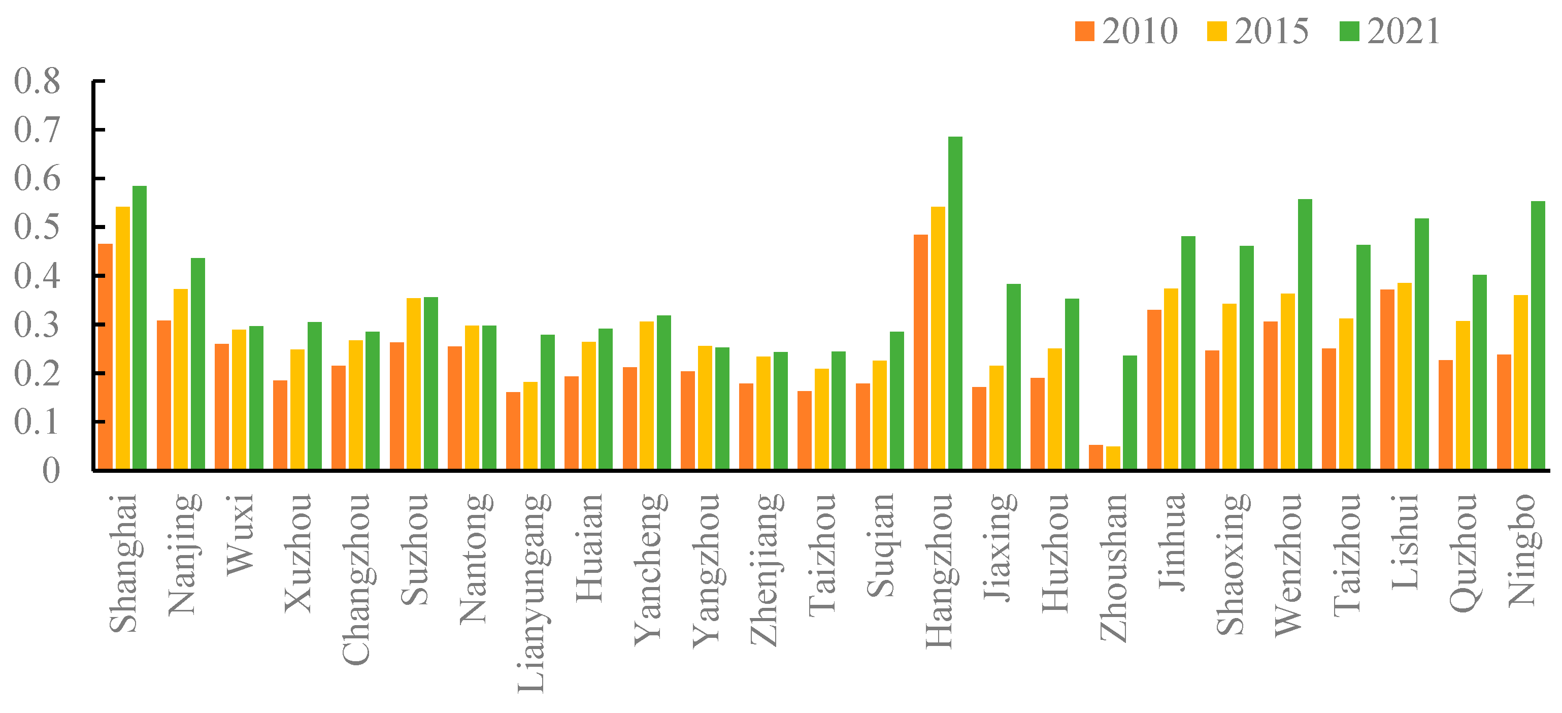
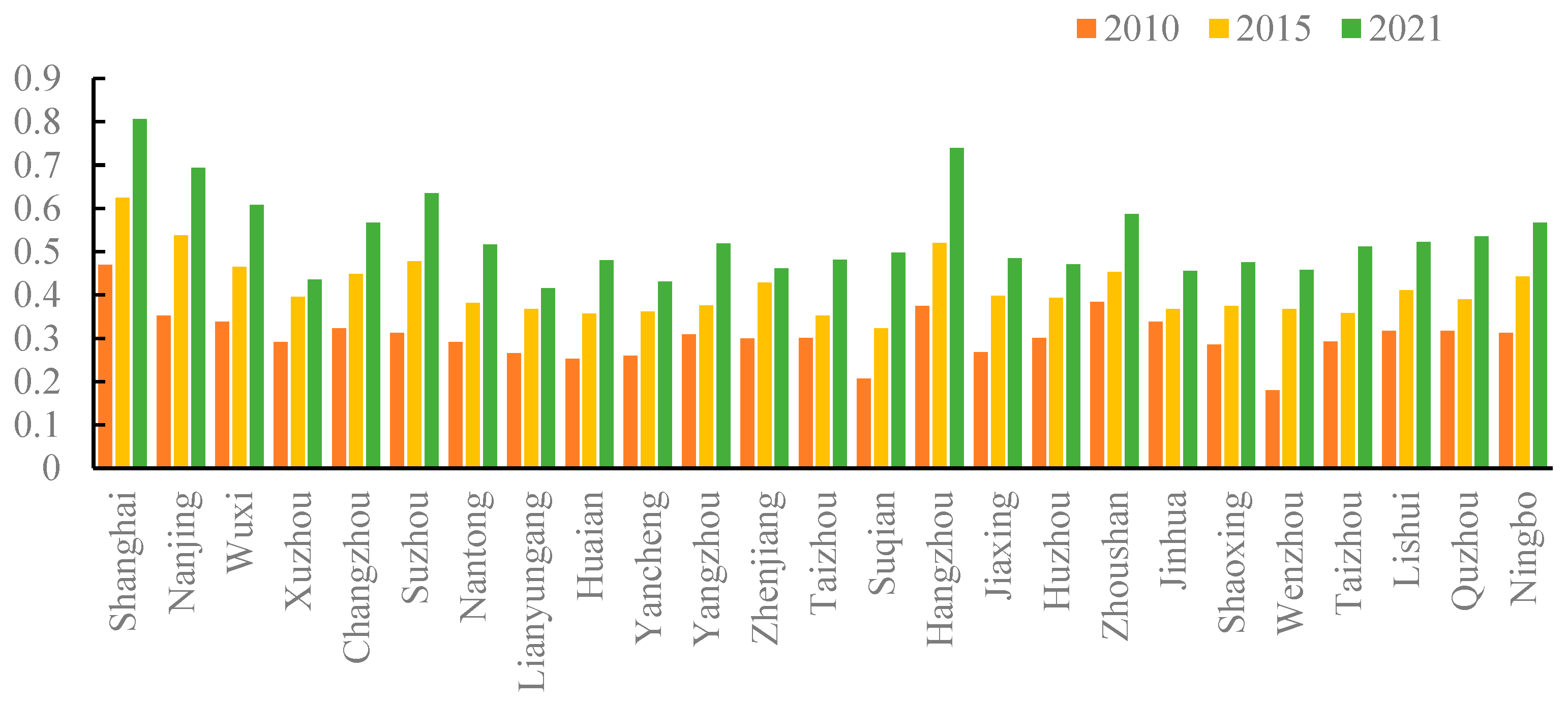
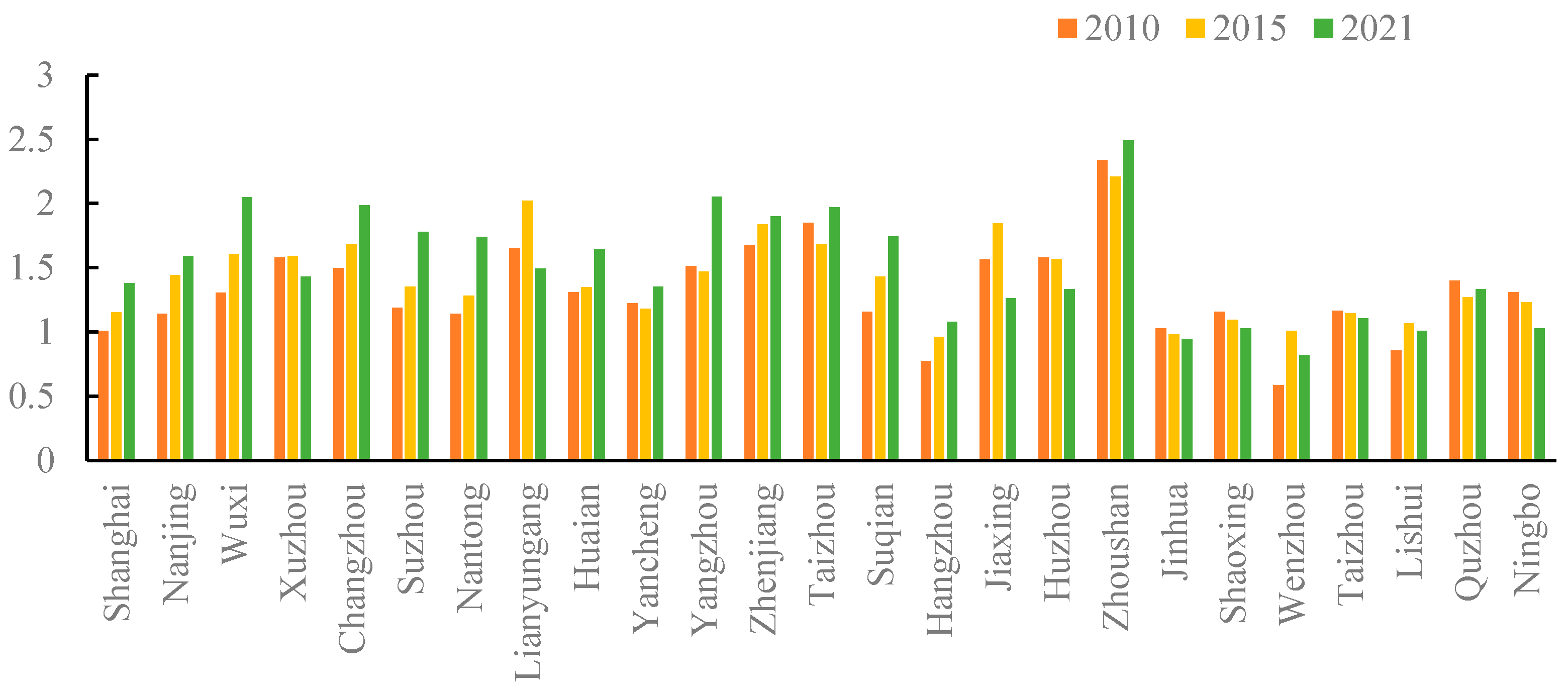
6.1. Temporal Evolution Analysis of Water Resource Systems and High-Quality Economic Indices

Utilizing Equations (1) and (2), the indices for water resource systems and high-quality economic development within the Yangtze River Delta from 2010 to 2021 were computed. The results for the years 2010, 2015, and 2021 are delineated in Figure 1 and Figure 2. As evinced by Figure 1, the mean value of the water resource system indices across the various jurisdictions exhibited a sustained upward trajectory, ascending from 0.24 to 0.38—an increment of 0.14, representing a growth rate of 58%. Except for Zhoushan, the water resource system indices for all other cities demonstrated an ascending trend from 2010 to 2015, with the cities of Ningbo, Yancheng, and Shaoxing registering the most substantial increments. In the period between 2015 and 2021, Yangzhou and Nantong saw a marginal decline in their water resource system indices, whereas all other cities maintained their upward momentum, with Zhoushan, Jiaxing, and Ningbo experiencing the most considerable uplift. This principally emanates from the heightened focus of local governments on water resource management, as the implementation of projects aimed at water pollution remediation and environmental construction has augmented the carrying capacity of water resources across these jurisdictions. Concurrently, demographic and economic advancements in certain regions have stimulated increased water consumption requirements.
Figure 2 reveals that the mean indices for high-quality economic development across various regions escalated from 0.31 to 0.53 between 2010 and 2021, marking an increment of 0.22 and a growth rate of 71%. In 2010, only Shanghai boasted a high-quality economic development index surpassing 0.4, with Wenzhou registering the nadir at 0.18. By 2015, this list had expanded to include Nanjing, Hangzhou, Suzhou, Wuxi, Zhoushan, Changzhou, Ningbo, Zhenjiang, and Lishui, all exhibiting an overarching upward trajectory, with Wenzhou, Suqian, Suzhou, and Nanjing manifesting particularly pronounced growth. By 2021, every city within the Yangtze River Delta had a high-quality economic development index exceeding 0.4, signifying a notable elevation in the quality of economic development. Historically, the region has been a magnet for substantial foreign capital and an influx of transient populations, thereby catalyzing urban population growth and the expansion of construction land. Concurrently, the provision of public services at the municipal governance level has been commensurately amplified, contributing favorably to high-quality economic growth.

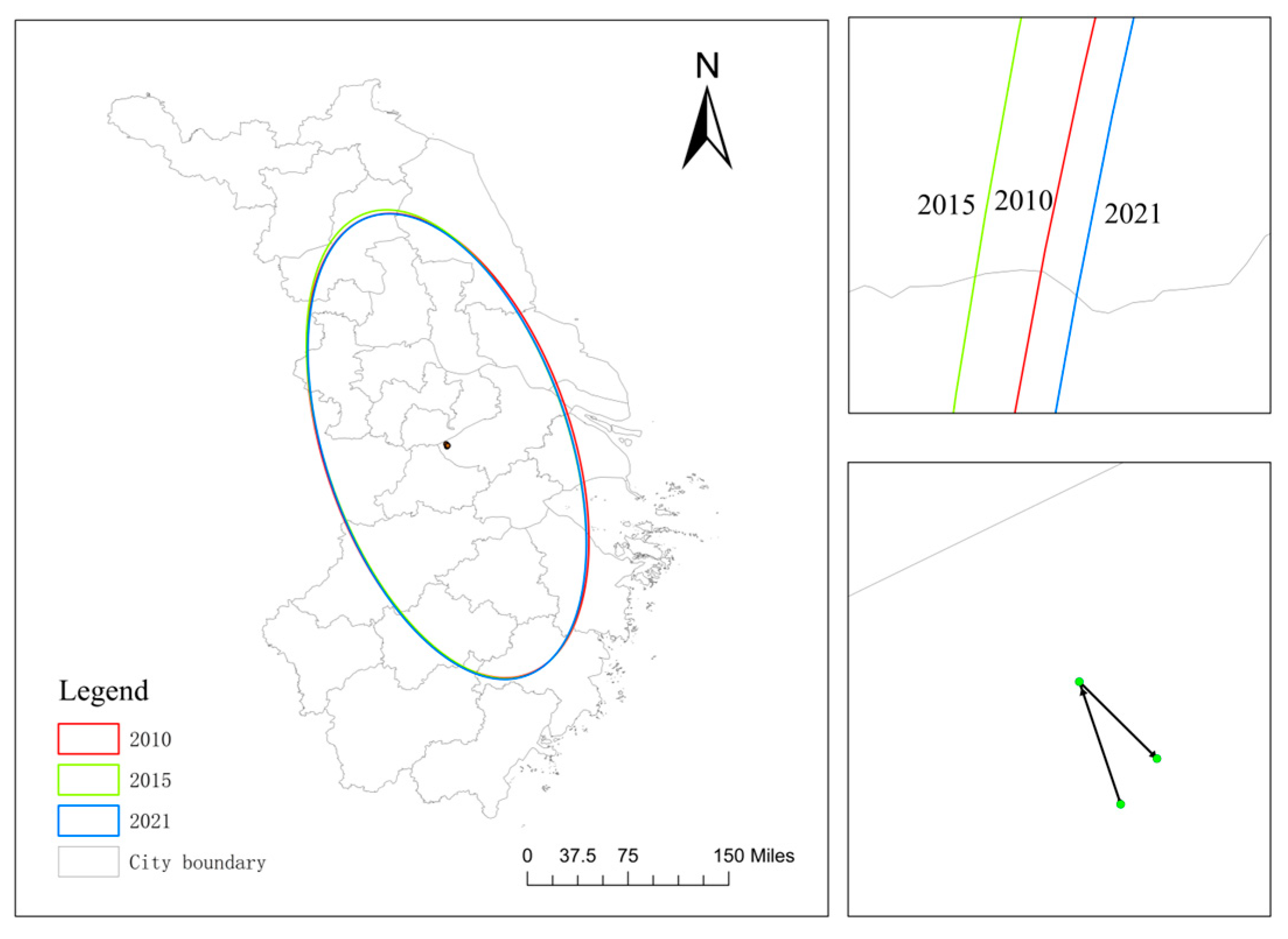
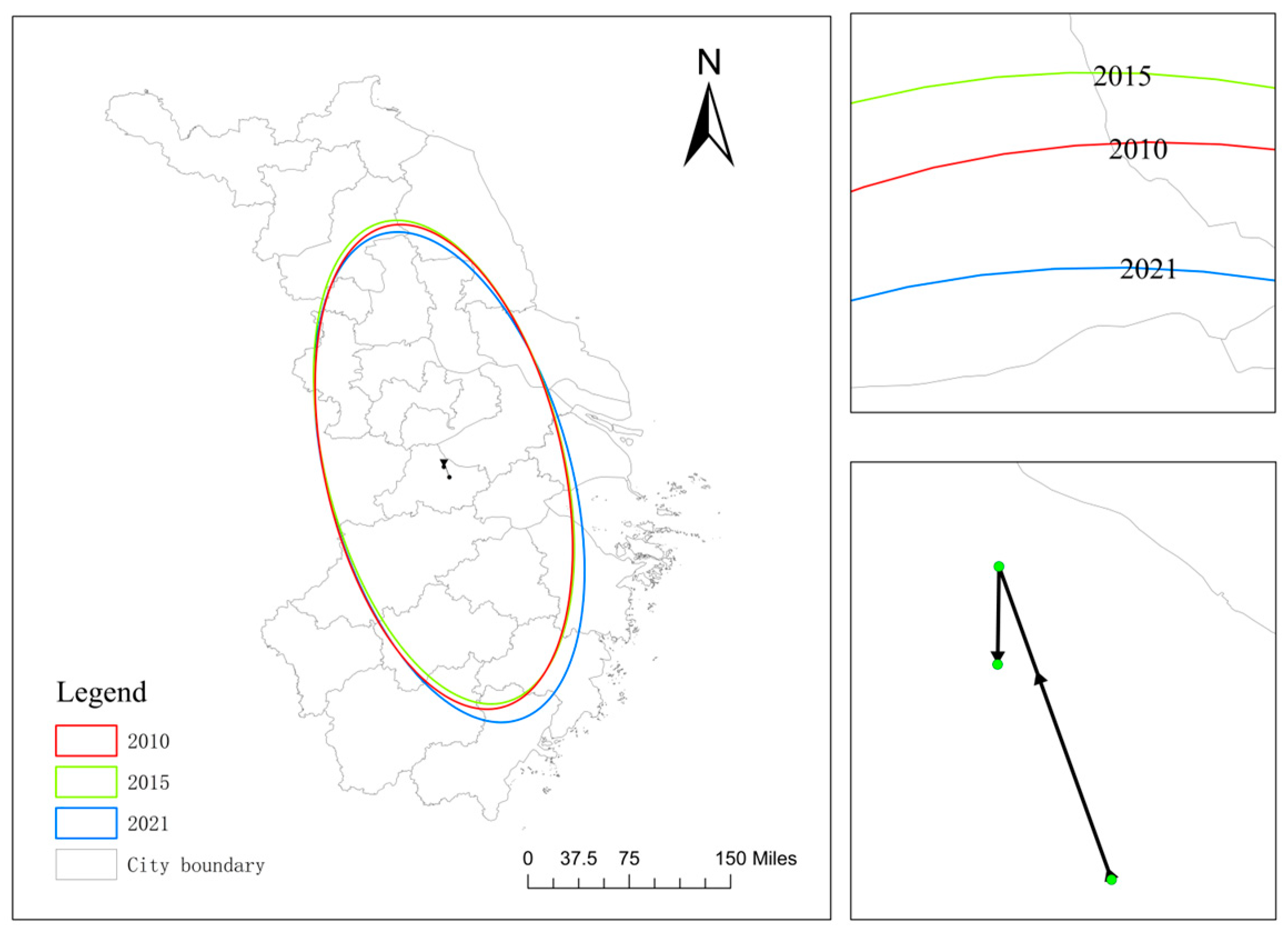
6.2. Analysis of Spatial Trends in Water Resource Systems and High-Quality Economic Indices

In order to rigorously delineate the spatiotemporal evolution of water resource systems in conjunction with high-quality economic development within the Yangtze River Delta, we employed Geographical Information Systems (GIS) to plot the standard deviational ellipses and centroidal shifts for these systems for the years 2010, 2015, and 2021. The overarching objective was to scrutinize the spatial equanimity between the two systems (Figure 3 and Figure 4). Figure 3 and Table 3 reveal that between 2010 and 2021, the centroid of water resource quality was predominantly situated in the northeastern region of Huzhou City. The orientation of the ellipse displayed a fluctuating trend, indicating a substantial degree of data dispersion, yet overall, it manifested an upward trajectory. Observationally, the spatial configuration of the water resources the Yangtze River Delta predominantly spans from the northwest to the southeast and substantially encompasses the majority of the central and eastern regions. From the detailed map of the ellipse position, the standard deviation ellipse position moves first to the northwest, then to the southeast, and overall becomes more and more eastward. Although the center of gravity of the ellipse moves to the northwest, the coverage is gradually expanding, indicating that the water resource elements are increasingly concentrated in the east-central region of Jiangsu, Zhejiang, and Shanghai, especially in the eastern coast of Wenzhou, Taizhou, Zhoushan, and so on, in the environmental quality of the outstanding performance makes the ellipse more skewed to the southeast and the coverage of a larger area.
Figure 4 and Table 3 elucidate that between 2010 and 2021, the epicenter of high-quality economic development was principally located in the vicinity of Lake Tai, at the confluence of Huzhou, Suzhou, and Wuxi, without any substantial alterations. The orientation of the ellipse remained relatively stable. Like the water resource system, the economic development ellipse also predominantly spans from the northwest to the southeast and substantially covers the central and eastern regions of the Yangtze River Delta. This suggests that the high-quality economic development has not led to egregiously disparate regional disparities. According to the detailed map, the ellipse of high-quality economic development is slowly moving eastward, and the center of gravity is shifting eastward as well. Further analysis ascertains that the southeastward inclination is correlated with the gravitational pull of technological talent in Shanghai and Suzhou, and is closely related to the integrated development demonstration areas formed in Suzhou Wujiang, Jiaxing Jiashan, and Shanghai Qingpu. Conversely, the northwestward inclination is associated with the elevated levels of economic and societal development in Nanjing, the provincial capital.

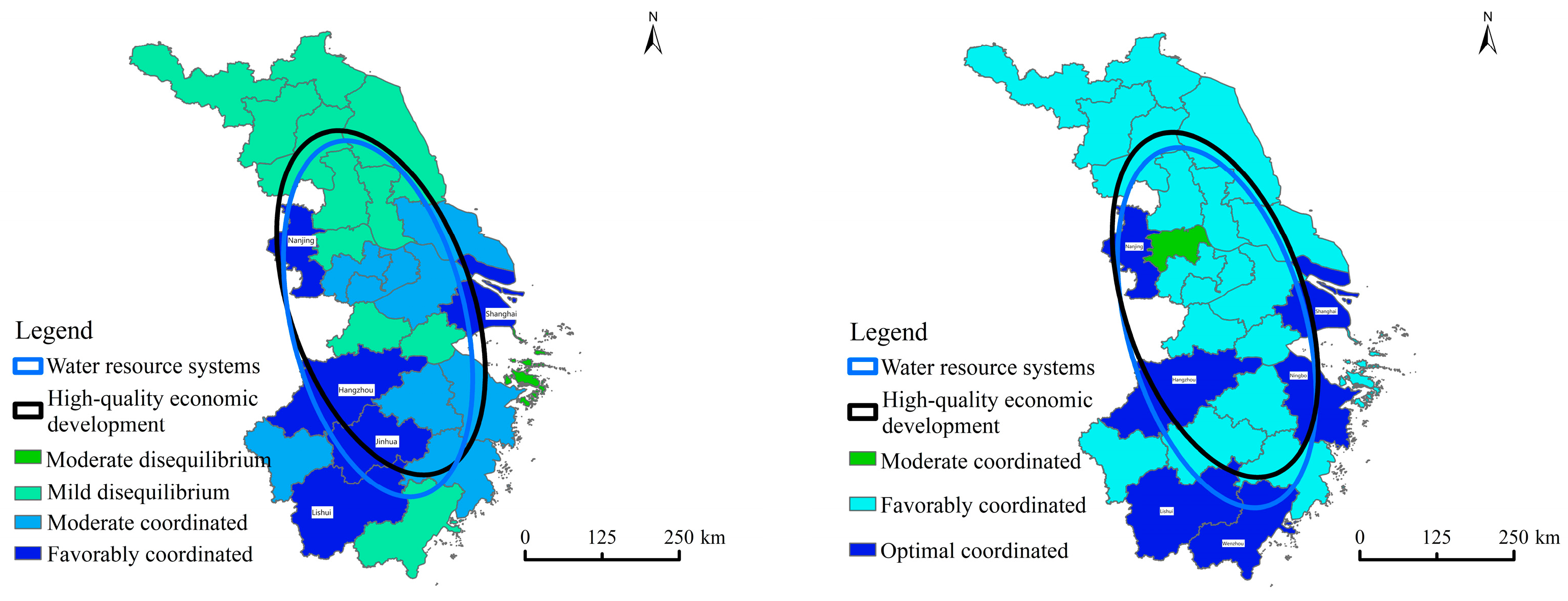
6.3. Coupling and Coordination Degree of Water Resource Systems and High-Quality Economic Development: Dynamic Changes over Time

According to the calculated results of the coordination degree of water resource systems and high-quality economic development in the Yangtze River Delta from 2010 to 2021, an analysis is conducted in conjunction with the classification criteria in Table 2 to assess the harmonious development between water resource systems and high-quality economic development (Figure 5). Between 2010 and 2015, the indices of coordination degree across various regions ranged from 0.2 to 0.7, encompassing categories such as moderate discoordination and decline, mild discoordination and decline, moderate harmonious development, and optimal harmonious development, indicating an overall trend toward beneficial progress. In 2010, areas exhibiting superior development included cities such as Shanghai, Hangzhou, Lishui, and Nanjing. This was partly attributed to the rapid economic growth in these cities, which placed a greater emphasis on economic harmonious development. Additionally, cities such as Lishui and Jinhua, with abundant water resources and high developmental carrying capacities, were conducive to coordinated development between the economy and water resources. By 2021, Shanghai and Hangzhou emerged as cities exemplifying exceptional coordinated development, with coordination degrees exceeding 0.7, while other cities all maintained coordination degrees greater than 0.5, falling within the realm of either moderate or optimal harmonious development.
According to Figure 6, which illustrates the relative development indices, the mean relative development degree for high-quality economic growth and water resource systems across various regions increased from 1.32 to 1.50 between 2010 and 2021—an increment of 0.18, representing a 14% growth rate, indicative of a pioneering trajectory in regional high-quality development. Within the Yangtze River Delta, advancements in economic prosperity, population growth, and societal evolution have precipitated an escalation in both domestic and industrial water consumption, thereby exerting considerable strain on the water resource systems and complicating their harmonious integration with economic objectives. Presently, while sustaining high-quality economic development, it is imperative to prioritize the conservation and judicious utilization of water resource systems to avert another severe imbalance with water resource carrying capacities and to foster a synergetic and efficient equilibrium between high-quality economic development and water resource utilization.

7. Conclusions and Discussion

7.1. Conclusions

Upon establishing a comprehensive evaluation index system, this study employs the CRITIC method, coupling-coordination models, and standard deviation ellipse models to scrutinize the dynamic coupling and coordination relationship between water resources and high-quality economic development across 25 cities in the Yangtze River Delta. The research ascertains that both the integrated utilization of water resources and the level of high-quality economic development in the region are on an upward trajectory. The coupling and coordination status has undergone a transition from moderate discoordination to optimal coordination, with the coupling type evolving from a medium-level adjustment to a high-level coordinated state. The epicenter of high-quality economic development is concentrated around Lake Taihu, particularly at the confluence of Huzhou, Suzhou, and Wuxi cities, exhibiting negligible shifts and maintaining a stable azimuth angle oriented from northwest to southeast, essentially enveloping the central and eastern portions of the Yangtze River Delta. The centroid of water resource system quality is located in the northeastern part of Huzhou City. Its azimuth angle manifests fluctuating tendencies, and the data exhibit a significant dispersion. Overall, the trend is ascending, and the spatial configuration is also oriented from northwest to southeast, broadly covering most areas in the central and eastern parts of the Yangtze River Delta.

7.2. Discussion

The issue of the relationship between the regional economy and the environment is an important part of the strategic topics such as the new normal of the Chinese economy, the construction of new urbanization, the construction of ecological civilization, and the new height of environmental protection in the new era. Currently, there are fewer studies on spatio-temporal patterns at small scales (prefectural municipalities and the following administrative units) based on large scales (large watersheds and national strategic regions); therefore, this paper selects data from 25 prefectural municipalities in Yangtze River Delta to measure the spatio-temporal patterns at small scales. The limitation of this paper is that it does not explore the relationship between the economic and environmental systems and their internal components of the subsystems, and only reflects the degree of coordination between the two systems from the numerical law, and also does not explore the many factors affecting the environmental system. In addition, in the selection of indicators for constructing the system, we consider the availability of data and based on previous research to screen out all of the indicators, in which there are inevitably oversights. In this paper, we have only conducted some preliminary explorations on economic and environmental issues in Jiangsu, Zhejiang and Shanghai, and we should strengthen further research on urbanization, economic development, ecological, and environmental effects of high-quality development, and refined measurement of environmental pollution and environmental quality in the future.
To harmonize the development of regional water resources with economic and social advancements, the following measures could be intensified. First, to carry out special remedial actions for the management of water abstraction, comprehensively carry out the verification and registration of water abstraction outlets, grasp the number of constructed water abstraction outlets, compliance and monitoring and measurement of the status quo, standardize the behavior of water abstraction, and improve the regulatory mechanism of water abstraction outlets, so as to lay a solid foundation for the management and control of water use. In areas where the verification and registration tasks have been completed, it is necessary to categorize and rectify the problems, and promote the development and utilization of water resources in the basin to improve the order significantly. Second, to solve the water problems in the Yangtze River Delta, we must grasp the crux of the problem, and implement the requirement of “making water resources a rigid constraint” without compromise, and adjust human behavior and correct human misbehavior in a timely manner through strong regulation, so as to promote upgrading and upgrading of industries, and advance the high-quality development of the economy and society. Third, strict water resource demonstration and water permit management, water resource conditions as an important constraint on the approval of relevant planning and construction projects, effectively strengthen the demonstration of water resource and water permit management, regulate the use of water in accordance with the law, and strictly supervise the aftermath of the incident. To promote the zonal management of water resource development and utilization, based on the evaluation of the carrying capacity of water resources, study the establishment of a zonal management system for the development and utilization of water resources, accurately identify basins and regions where water resources are over-exploited, moderately exploited, and under-exploited, and implement differentiated regulatory policies, so as to improve the level of management refinement, and to better facilitate the balancing of the population, urban and industrial development with water resource conditions. Fourthly, give play to the incentive and spurring role of the most stringent water resource management system assessment. Further improve the assessment content, optimize the assessment indicators, improve the assessment mechanism, and give greater play to the role of the assessment baton. Further strengthen the daily inspection, take random checks, unannounced visits, and other ways, strict implementation of supervision and inspection, to promote the local and relevant units to fulfill their duties in accordance with the law, and improve the management capacity and level. We should take warning and disciplinary actions as the guide, and urge immediate rectification of the problems found, and resolutely investigate, punish, and hold accountable those with serious problems.

Author Contributions

Conceptualization and methodology, G.Y.; resources and writing, D.L.; project administration and funding acquisition, Q.D. All authors have read and agreed to the published version of the manuscript.

Funding

This research received no external funding.

Data Availability Statement

The data used in this paper are all from the statistical data officially released by China.

Conflicts of Interest

The authors declare no conflict of interest.

References

  1. Hashimoto, T.; Stedinger, J.R.; Loucks, D.P. Reliability, resiliency, and vulnerability criteria for water resource system performance evaluation. Water Resour. Res. 1982, 18, 14–20. [Google Scholar]
  2. Dee, N.; Baker, J.; Drobny, N.; Duke, K.; Whitman, I.; Fahringer, D. An environmental evaluation system for water resource planning. Water Resour. Res. 1973, 9, 523–535. [Google Scholar]
  3. Hitchcock, R.K. Water resource use and management in the Okavango system of southern Africa: The political economy of state, community and private resource control. Botsw. Notes Rec. 1999, 31, 83–92. [Google Scholar]
  4. Kalhor, K.; Emaminejad, N. Sustainable development in cities: Studying the relationship between groundwater level and urbanization using remote sensing data. Groundw. Sustain. Dev. 2019, 9, 100243. [Google Scholar]
  5. Hall, B.; Currell, M.; Webb, J. Using multiple lines of evidence to map groundwater recharge in a rapidly urbanizing catchment: Implications for future land and water management. J. Hydrol. 2020, 580, 124265. [Google Scholar]
  6. Minnig, M.; Moeck, C.; Radny, D.; Schirmer, M. Impact of urbanization on groundwater recharge rates in Dübendorf, Switzerland. J. Hydrol. 2018, 563, 1135–1146. [Google Scholar]
  7. Pienaar, A.; Brent, A.C.; Musango, J.K.; De Kock, I.H. Water resource infrastructure implications of a green economy transition in the Western Cape Province of South Africa: A system dynamics approach. S. Afr. J. Ind. Eng. 2017, 28, 78–94. [Google Scholar]
  8. Salerno, F.; Gaetano, V.; Gianni, T. Urbanization and climate change impacts on surface water quality: Enhancing the resilience by reducing impervious surfaces. Water Res. 2018, 144, 491–502. [Google Scholar]
  9. Ren, B.; Sun, B.; Shi, X.; Zhao, S.; Wang, X. Analysis of the cooperative carrying capacity of Ulan Suhai Lake based on the coupled water resources–water environment–water ecology system. Water 2022, 14, 3102. [Google Scholar]
  10. Luo, Z.; Zuo, Q. Evaluating the coordinated development of social economy, water, and ecology in a heavily disturbed basin based on the distributed hydrology model and the harmony theory. J. Hydrol. 2019, 574, 226–241. [Google Scholar]
  11. Jia, S.; Zhang, S.; Yang, H.; Jun, X. Relationship between industrial water use and economic development—Kuznets curve of water use. J. Nat. Resour. 2004, 19, 279–284. [Google Scholar]
  12. Fu, M. Environmental Kunets Curve in China: Shape, Inflection Points and Influencing Factors. Quant. Tech. Econ. Res. 2008, 25, 40–55. [Google Scholar]
  13. Tong, H.; Yang, Y.; Wang, J.; Feng, Y. Outlook of China’s green economy development—Scenario analysis based on system dynamics model. China Soft Sci. 2015, 6, 20–34. [Google Scholar]
  14. Rueff, H.; Rahim, I.U.; Kohler, T.; Mahat, T.J.; Ariza, C. Can the green economy enhance sustainable mountain development? The potential role of awareness building. Environ. Sci. Policy 2015, 49, 85–94. [Google Scholar]
  15. Song, D.; Ma, Y. Research on the coupling of green water utilization rate and economic high-quality development in the Yellow River Basin—Taking Henan Province as an example. Ecol. Econ. 2021, 37, 14–19+42. [Google Scholar]
  16. Xiong, Y.; Su, M.; Zhang, F.; Li, J. Study on the relationship between urbanization process and water resources use response in ChangZhuTan city cluster. Hum. Geogr. 2018, 33, 69–76. [Google Scholar] [CrossRef]
  17. Han, R.; Tong, L.; Tong, W.; Yu, J. Progress and review of research on the relationship between economic and environmental development. China Popul. Resour. Environ. 2012, 22, 119–124. [Google Scholar]
  18. Shi, Y.; Zhu, X.; Sun, X.; Li, Y.; Wei, T. Dynamic evaluation of coordinated development of regional economic-environmental composite ecosystems: Taking Lianyungang as an example. J. Ecol. 2010, 30, 4119–4128. [Google Scholar]
  19. Di, D.; Wu, Z.; Guo, X.; Lv, C.; Wang, H. Value stream analysis and emergy evaluation of the water resource eco-economic system in the Yellow River Basin. Water 2019, 11, 710. [Google Scholar] [CrossRef]
  20. Lv, S.; Ma, Y.; Ye, J.; Li, Q. Study on the quantitative relationship between urbanization and water resources utilization in the Central Plains city cluster. J. Irrig. Drain. 2016, 35, 7–12. [Google Scholar] [CrossRef]
  21. Ren, B.; Du, Y. Coupled synergistic relationship of economic growth-industrial development-ecological environment in the Yellow River Basin. China Popul. Resour. Environ. 2021, 31, 119–129. [Google Scholar]
  22. Fan, J.; Wang, Y.; Wang, Y. Research on regional high-quality development based on geographic units—Another discussion on the difference in conditions and focus of development between the Yellow River Basin and the Yangtze River Basin. Econ. Geogr. 2020, 40, 1–11. [Google Scholar]
  23. Zhang, L.; Qiu, S.; Yan, L.; Du, J.; Shen, H. Analysis of coupled coordination between water resources utilization and economic and social development in Henan Province based on basin perspective. Reg. Res. Dev. 2022, 41, 14–19. [Google Scholar]
  24. Jiao, W.; Min, Q.; Li, W.; Anthony, M.F. Water ecological carrying capacity based on ESEF: Theory, modeling and application. J. Appl. Ecol. 2015, 26, 1041–1048. [Google Scholar]
  25. Liu, S.; Chen, J. Research on water resources carrying capacity based on neural network theory. Resour. Sci. 2007, 9, 99–105. [Google Scholar]
  26. Yang, L.; Ren, Y.; Wang, Z.; Hang, Z.; Luo, Y. Simulation and Economic Research of Circulating Cooling Water Waste Heat and Water Resource Recovery System. Energies 2021, 14, 2496. [Google Scholar] [CrossRef]
  27. Xue, J.; Chen, W.; Zhang, L. Measurement and Spatial Pattern of Comprehensive Urbanization Level in Chinese Municipalities. Econ. Geogr. 2010, 30, 2005–2011. [Google Scholar]
  28. Deng, H.; Yang, L.; Pan, X. Whether the opening of high-speed railroad can help industrial structure upgrade: Facts and mechanisms. Financ. Res. 2020, 46, 34–48. [Google Scholar]
  29. Xu, L.; Huang, Y.; Liu, A. Study on water resources carrying capacity of Jiangsu Province based on principal component analysis. Yangtze River Basin Resour. Environ. 2011, 20, 1468–1474. [Google Scholar]
  30. Duan, X.; Luan, F. Evaluation of water resources carrying capacity in Xinjiang based on fuzzy comprehensive judgment. China Popul. Resour. Environ. 2014, 24 (Suppl. S1), 119–122. [Google Scholar]
  31. Su, W.; Wang, C. Research on the evaluation of urban water resources carrying capacity in Sichuan Province based on DEA. J. Southwest Univ. Natl. (Humanit. Soc. Sci. Ed.) 2015, 36, 116–119. [Google Scholar]
  32. Cao, Z.; Dong, H.; Han, Y. Research on the mechanism of industrial agglomeration on total factor productivity and regional heterogeneity. Soft Sci. 2020, 34, 50–58. [Google Scholar] [CrossRef]
  33. Zheng, D.; Xu, W.; Jiang, J.; Lv, L. Analysis of the evolutionary trend and coordinated development of water resources carrying capacity and urbanization quality in China. Econ. Geogr. 2021, 41, 72–81. [Google Scholar] [CrossRef]
Figure 1. Temporal evolution of water resource system indices in the Yangtze River Delta.
Water 15 04030 g001
Figure 2. Time evolution of economic quality development index in the Yangtze River Delta.
Water 15 04030 g002
Figure 3. Spatial distribution of water resource systems in the Yangtze River Delta.
Water 15 04030 g003
Figure 4. Spatial distribution of high-quality economic development in the Yangtze River Delta.
Water 15 04030 g004
Figure 5. Degree of development and spatial ellipse of the coupling between water resource systems and high-quality economic development in the Yangtze River Delta ((left) 2010, (right) 2021).
Water 15 04030 g005
Figure 6. Relative development of water resource systems and high-quality economic development in the Yangtze River Delta.
Water 15 04030 g006
Table 1. Indicator system for evaluating water resource system and high-quality economic development.
Objective LayerCriteria LayerIndicator LayerUnitWeightAttribute
Water Resource SystemWater Resource AvailabilityTotal Water Resources10,000 m30.150+
Annual Precipitation10,000 m30.170+
Water Resource UtilizationTotal Urban Water Supply10,000 m30.169+
Domestic Water Consumption per Capita10,000 m30.152+
Industrial Water Consumption10,000 m30.102
Water Resource ConservationIndustrial Wastewater Discharge10,000 m30.057
Wastewater Treatment Rate%0.200+
High-Quality Economic DevelopmentIndustrial StructureIndustrial Advancement Index-0.104+
Rationalization of Industrial Structure-0.110+
Proportion of Productive Service Sector%0.132+
Technological InnovationNumber of Patents GrantedIndividual0.097+
Ecological EnvironmentGreen Coverage Rate in Built-up Areas%0.103+
Comprehensive Utilization Rate of Industrial Solid Waste%0.103+
Standard of LivingPer Capita GDPYuan/Person0.155+
Per Capita Education ExpenditureYuan/Person0.108+
Hospital Bed Availability per 10,000 PeopleBeds/10,000 People0.089+
Note: Source: Statistical Yearbook and Statistical Bulletin of Municipalities.
Table 2. Classification criteria for coupling coordination degrees.
Range of Coupling Coordination Degree D ValueLevel of Coupling CoordinationDevelopmental TierCoordinated Developmental Tier
[0.0~0.3]Severe DisequilibriumSevere RegressionCritical Disequilibrium and Regression
(0.3~0.4]Moderate DisequilibriumModerate RegressionModerate Disequilibrium and Regression
(0.4~0.5]Mild DisequilibriumMild RegressionMild Disequilibrium and Regression
(0.5~0.55]Moderate CoordinationModerate DevelopmentModerate Coordinated Advancement
(0.55~0.7]Good CoordinationFavorable DevelopmentFavorably Coordinated Advancement
(0.7~1.0]Optimal CoordinationOptimal DevelopmentOptimal Coordinated Advancement
Table 3. Parameters of standard deviation ellipses for water resources systems and high-quality economic development in the Yangtze River Delta.
IndexYearCentroid CoordinatesStandard Deviation along X-AxisStandard Deviation along Y-AxisAzimuth Angle
LongitudeLatitude
Water Resources System2010119°59′2.612″30°55′49.256″2.6509291.273938166.76
2015119°59′5.183″30°58′50.29″2.6551531.271567165.64
2021120°24′9.608″30°49′10.88″2.7034581.301092164.38
High-Quality Economic Development2010120°1′36.44″31°9′45.907″2.613561.33335160.94
2015120°0′38.563″31°10′43.28″2.641051.308516160.83
2021120°1′9.404″31°9′11.851″2.6176771.313448161.20
Disclaimer/Publisher’s Note: The statements, opinions and data contained in all publications are solely those of the individual author(s) and contributor(s) and not of MDPI and/or the editor(s). MDPI and/or the editor(s) disclaim responsibility for any injury to people or property resulting from any ideas, methods, instructions or products referred to in the content.

