


Influence of Teleconnection Factors on Extreme Precipitation in Henan Province under Urbanization


Abstract
:1. Introduction
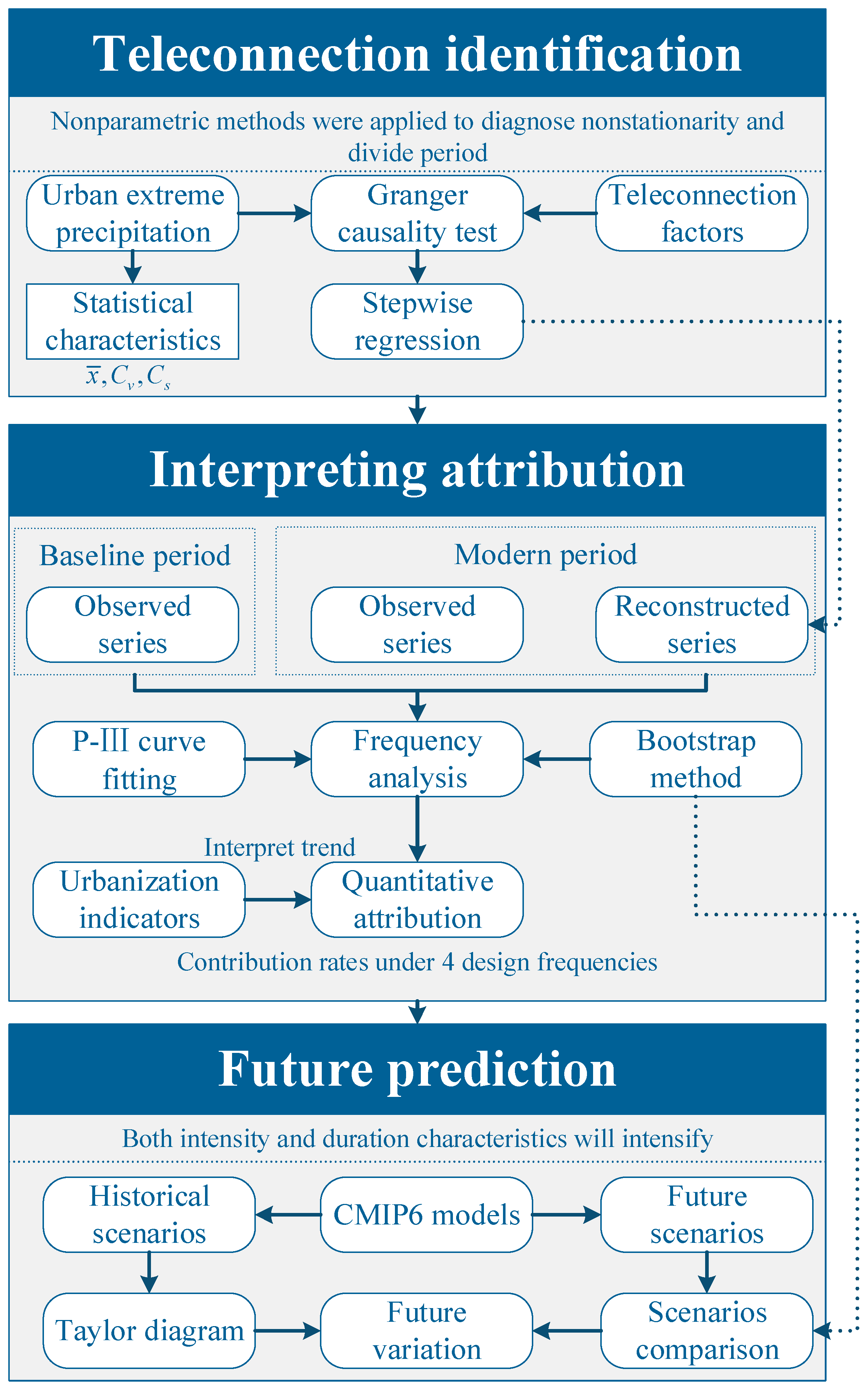
2. Methodology
2.1. Extreme Precipitation Connotation and Selection of Statistical Indicators
2.2. Principle of Granger Causality Test
2.3. Contribution of Teleconnection Factors and Urbanization to Urban Extreme Precipitation
3. Case Study
3.1. Study Area
3.2. Data
4. Results and Discussion
4.1. Temporal and Spatial Variations of Urban Extreme Precipitation under Urbanization
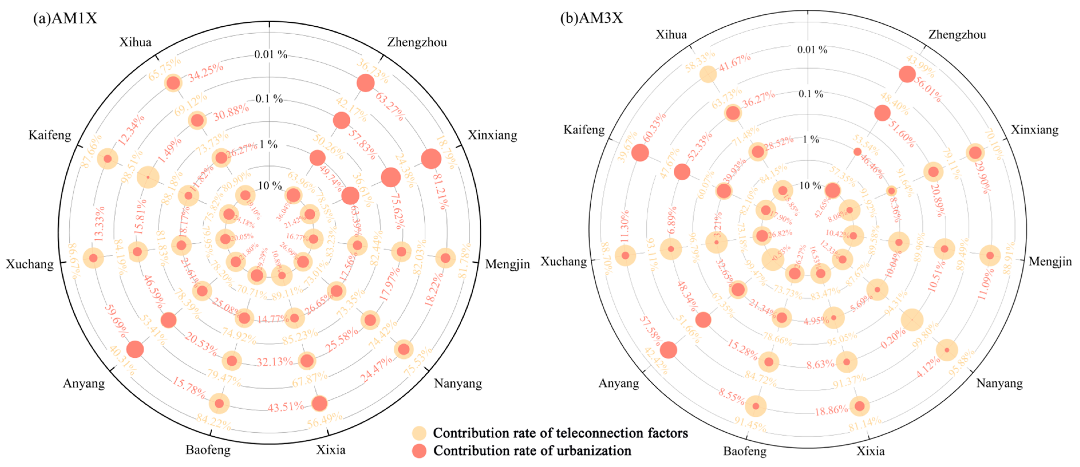
4.2. The Dominant Teleconnection Factors of Urban Extreme Precipitation
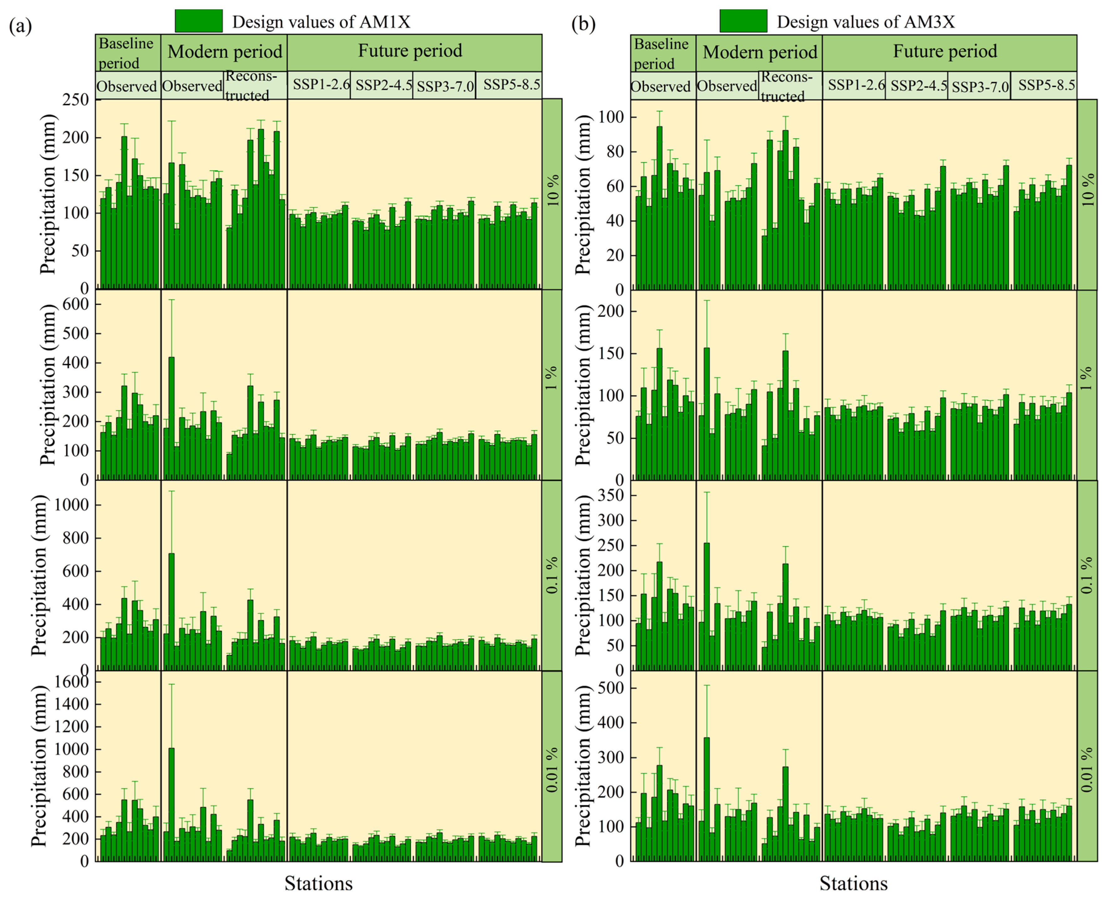
4.3. The Influence of Teleconnection on Urban Extreme Precipitation under Urbanization
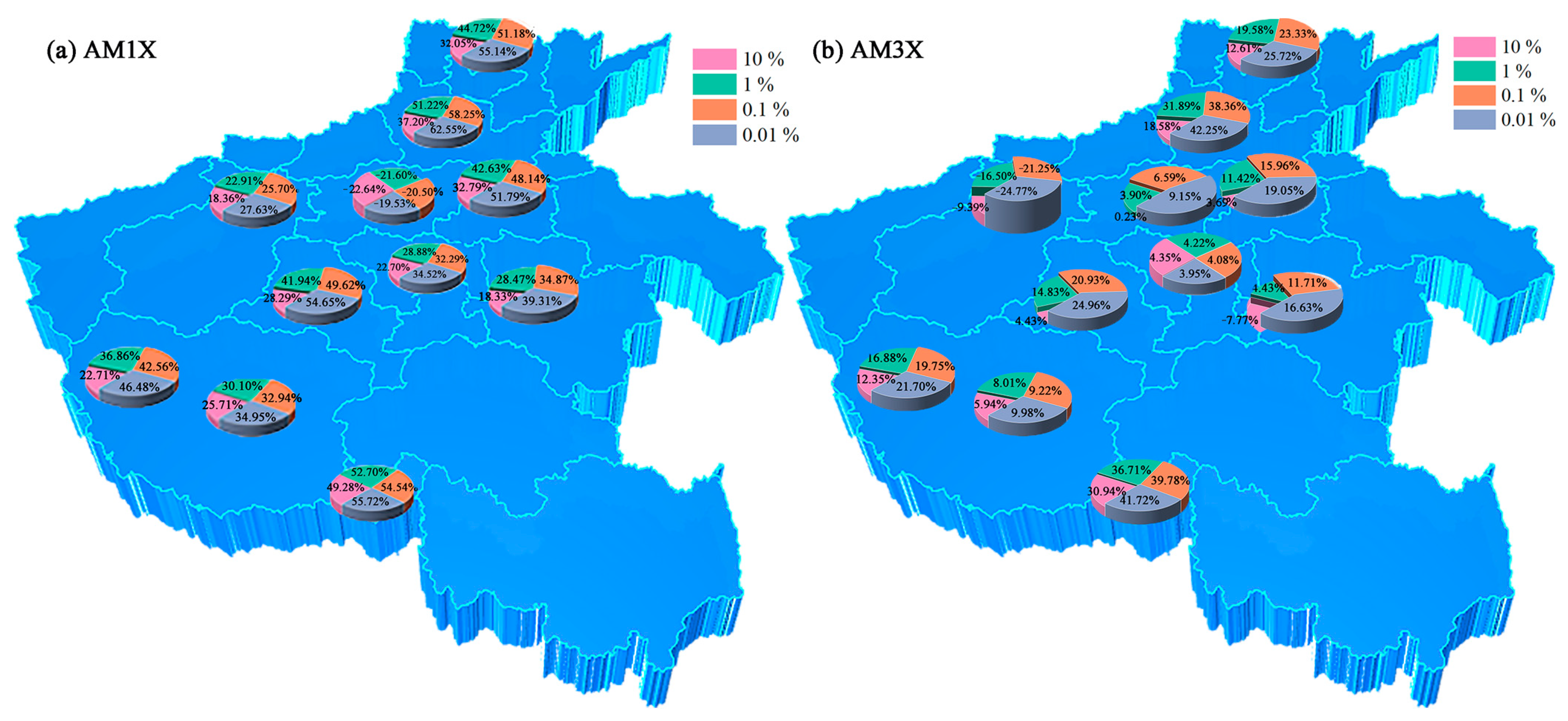
4.4. Prediction of Future Extreme Precipitation
5. Conclusions
Author Contributions
Funding
Data Availability Statement
Acknowledgments
Conflicts of Interest
References
- Wang, J.; Feng, J.; Wu, Q.; Yan, Z. Impact of anthropogenic aerosols on summer precipitation in the Beijing–Tianjin–Hebei urban agglomeration in China: Regional climate modeling using WRF-Chem. Adv. Atmos. Sci. 2016, 33, 753–766. [Google Scholar] [CrossRef]
- Ajaaj, A.A.; Mishra, A.K.; Khan, A.A. Urban and peri-urban precipitation and air temperature trends in mega cities of the world using multiple trend analysis methods. Theor. Appl. Climatol. 2017, 132, 403–418. [Google Scholar] [CrossRef]
- Kang, C.; Luo, Z.; Zong, W.; Hua, J. Impacts of urbanization on variations of extreme precipitation over the Yangtze River Delta. Water 2021, 13, 150. [Google Scholar] [CrossRef]
- Li, Y.; Wang, W.; Chang, M.; Wang, X. Impacts of urbanization on extreme precipitation in the Guangdong-Hong Kong-Macau Greater Bay Area. Urban Clim. 2021, 38, 100904. [Google Scholar] [CrossRef]
- Han, L.; Xu, Y.; Pan, G.; Deng, X.; Hu, C.; Xu, H.; Shi, H. Changing properties of precipitation extremes in the urban areas, Yangtze River Delta, China, during 1957–2013. Nat. Hazards 2015, 79, 437–454. [Google Scholar] [CrossRef]
- Oh, S.-G.; Son, S.-W.; Min, S.-K. Possible impact of urbanization on extreme precipitation–temperature relationship in East Asian megacities. Weather Clim. Extrem. 2021, 34, 100401. [Google Scholar] [CrossRef]
- Zhang, D.L. Rapid urbanization and more extreme rainfall events. Sci. Bull. 2020, 65, 516–518. [Google Scholar] [CrossRef]
- Zhang, Y.; Pang, X.; Xia, J.; Shao, Q.; Yu, E.; Zhao, T.; She, D.; Sun, J.; Yu, J.; Pan, X.; et al. Regional patterns of extreme precipitation and urban signatures in metropolitan areas. J. Geophys. Res. Atmos. 2019, 124, 641–663. [Google Scholar] [CrossRef]
- Silva, F.N.; Vega-Oliveros, D.A.; Yan, X.; Flammini, A.; Menczer, F.; Radicchi, F.; Kravitz, B.; Fortunato, S. Detecting climate teleconnections with Granger Causality. Geophys. Res. Lett. 2021, 48, e2021GL094707. [Google Scholar] [CrossRef]
- Yoo, C.; Johnson, N.C.; Chang, C.-H.; Feldstein, S.B.; Kim, Y.-H. Subseasonal prediction of wintertime east Asian temperature based on atmospheric teleconnections. J. Clim. 2018, 31, 9351–9366. [Google Scholar] [CrossRef]
- Zhao, S.; Zhang, J. Causal effect of the tropical Pacific sea surface temperature on the upper Colorado river basin spring precipitation. Clim. Dyn. 2022, 58, 941–959. [Google Scholar] [CrossRef]
- Deng, Z.; Wang, Z.; Wu, X.; Lai, C.; Liu, W. Effect difference of climate change and urbanization on extreme precipitation over the Guangdong-Hong Kong-Macao Greater Bay Area. Atmos. Res. 2023, 282, 106514. [Google Scholar] [CrossRef]
- Wei, N.; Wang, N.; Zheng, Y.; Liu, H. Contribution of climate change and urbanization to the variation of extreme precipitation in the urban agglomerations over the Loess Plateau. Hydrol. Process. 2022, 36, e14489. [Google Scholar] [CrossRef]
- Lin, L.; Gao, T.; Luo, M.; Ge, E.; Yang, Y.; Liu, Z.; Zhao, Y.; Ning, G. Contribution of urbanization to the changes in extreme climate events in urban agglomerations across China. Sci. Total Environ. 2020, 744, 140264. [Google Scholar] [CrossRef]
- Song, X.; Qi, J.; Zou, X.; Zhang, J.; Liu, C. Potential effects of urbanization on precipitation extremes in the Pearl River Delta region, China. Water 2022, 14, 2466. [Google Scholar] [CrossRef]
- Zhu, X.; Zhang, Q.; Sun, P.; Singh, V.P.; Shi, P.; Song, C. Impact of urbanization on hourly precipitation in Beijing, China: Spatiotemporal patterns and causes. Glob. Planet. Chang. 2019, 172, 307–324. [Google Scholar] [CrossRef]
- Paul, S.; Ghosh, S.; Mathew, M.; Devanand, A.; Karmakar, S.; Niyogi, D. Increased spatial variability and intensification of extreme monsoon rainfall due to urbanization. Sci. Rep. 2018, 8, 3918. [Google Scholar] [CrossRef]
- Xu, Y.; Chen, X.; Liu, M.; Wang, J.; Zhang, F.; Cui, J.; Zhou, H. Spatial–temporal relationship study between NWP PWV and precipitation: A case study of ‘July 20’ Heavy Rainstorm in Zhengzhou. Remote Sens. 2022, 14, 3636. [Google Scholar] [CrossRef]
- Sun, J.; Fu, S.; Wang, H.; Zhang, Y.; Chen, Y.; Su, A.; Wang, Y.; Tang, H.; Ma, R. Primary characteristics of the extreme heavy rainfall event over Henan in July 2021. Atmos. Sci. Lett. 2022, 24, e1131. [Google Scholar] [CrossRef]
- Qin, H.; Yuan, W.; Wang, J.; Chen, Y.; Dai, P.; Sobel, A.H.; Meng, Z.; Nie, J. Climate change attribution of the 2021 Henan extreme precipitation: Impacts of convective organization. Sci. China Earth Sci. 2022, 65, 1837–1846. [Google Scholar] [CrossRef]
- Liu, X.; Yang, M.; Wang, H.; Liu, K.; Dong, N.; Wang, H.; Zhang, L.; Fan, W. Moisture sources and atmospheric circulation associated with the record-breaking rainstorm over Zhengzhou city in July 2021. Nat. Hazards 2023, 116, 817–836. [Google Scholar] [CrossRef]
- Zhang, G.; Mao, J.; Hua, W.; Wu, X.; Sun, R.; Yan, Z.; Liu, Y.; Wu, G. Synergistic effect of the planetary-scale disturbance, Typhoon and Meso-β-scale convective vortex on the extremely intense rainstorm on 20 July 2021 in Zhengzhou. Adv. Atmos. Sci. 2023, 40, 428–446. [Google Scholar] [CrossRef]
- Yin, J.; Gu, H.; Liang, X.; Yu, M.; Sun, J.; Xie, Y.; Li, F.; Wu, C. A possible dynamic mechanism for rapid production of the extreme hourly rainfall in Zhengzhou City on 20 July 2021. J. Meteorol. Res. 2022, 36, 6–25. [Google Scholar] [CrossRef]
- Wei, P.; Xu, X.; Xue, M.; Zhang, C.; Wang, Y.; Zhao, K.; Zhou, A.; Zhang, S.; Zhu, K. On the key dynamical processes supporting the 21.7 Zhengzhou record-breaking hourly rainfall in China. Adv. Atmos. Sci. 2022, 40, 337–349. [Google Scholar] [CrossRef]
- Deng, L.; Feng, J.; Zhao, Y.; Bao, X.; Huang, W.; Hu, H.; Duan, Y. The remote effect of binary Typhoon Infa and Cempaka on the “21.7” heavy rainfall in Henan Province, China. J. Geophys. Res. Atmos. 2022, 127, 16. [Google Scholar] [CrossRef]
- Wang, H.; Wang, H.; Li, H.; Faisal, M.; Zhang, Y. Analysis of drainage efficiency under extreme precipitation events based on numerical simulation. Hydrol. Process. 2022, 36, e14624. [Google Scholar] [CrossRef]
- Zhao, Y.; Son, S.W.; Back, S.Y. The critical role of the upper-level synoptic disturbance on the China Henan “21.7” extreme precipitation event. SOLA 2023, 19, 42–49. [Google Scholar] [CrossRef]
- Efron, B.; Tibshirani, R. Bootstrap methods for standard errors, confidence intervals, and other measures of statistical accuracy. With a comment by J. A. Hartigan and a rejoinder by the authors. Stat. Sci. 1986, 1, 54–77. [Google Scholar] [CrossRef]
- Granger, C.W.J. Investigating causal relations by econometric models and cross-spectral methods. Econometrica 1969, 37, 424–438. [Google Scholar] [CrossRef]
- Yin, L.; Ping, F.; Mao, J.; Jin, S. Analysis on precipitation efficiency of the “21.7” Henan extremely heavy rainfall event. Adv. Atmos. Sci. 2022, 40, 374–392. [Google Scholar] [CrossRef]
- Li, H.; Moisseev, D.; Luo, Y.; Liu, L.; Ruan, Z.; Cui, L.; Bao, X. Assessing specific differential phase (KDP)-based quantitative precipitation estimation for the record- breaking rainfall over Zhengzhou city on 20 July 2021. Hydrol. Earth Syst. Sci. 2023, 27, 1033–1046. [Google Scholar] [CrossRef]
- Henan Province Bureau of Statistics. Henan Statistical Yearbook; China Statistics Press: Beijing, China, 2002–2022. [Google Scholar]
- Mann, H.B. Nonparametric tests against trend. Econometrica 1945, 13, 245–259. [Google Scholar] [CrossRef]
- Kendall, M. Rank Correlation Methods; Griffin: London, UK, 1975. [Google Scholar]
- Pettitt, A.N. A non-parametric approach to the change-point problem. J. R. Stat. Soc. Ser. C Appl. Stat. 1979, 28, 126. [Google Scholar] [CrossRef]
- Taylor, K.E. Summarizing multiple aspects of model performance in a single diagram. J. Geophys. Res. 2001, 106, 7183–7192. [Google Scholar] [CrossRef]


| Data Type | Detail | Source | Scale | Span |
|---|---|---|---|---|
| Precipitation | Zhengzhou (Zhengzhou City), Xinxiang (Xinxiang City), Mengjin (Luoyang City), Nanyang (Nanyang city), Tongbai (Nanyang City), Xixia (Nanyang City), Baofeng (Pingdingshan City), Anyang (Anyang City), Xuchang (Xuchang City), Kaifeng (Kaifeng City), Xihua (Zhoukou City) | NCC | Daily | 1951–2021 |
| Teleconnection factors | 88 atmospheric circulation indexes, 26 Sea Surface Temperature (SST) indexes, 16 other indexes | NCC | Monthly | 1951–2021 |
| GCMs | IPSL-CM6A-LR | Institute Pierre-Simon Laplace (IPSL), Europe | 2.5° × 1.26° | 1951–2100 |
| MRI-ESM2-0 | Meteorological Research Institute (MRI), Japan | 1.125° × 1.125° | 1951–2100 | |
| CNRM-ESM2-1 | CNRM-CERFACS, France | 1.4° × 1.4° | 1951–2100 | |
| CanESM5 | Canadian Centre for Climate Modelling and Analysis (CCCma), Canada | 2. 8° × 2.8° | 1951–2100 | |
| MIROC6 | MIROC, Japan | 1.4° × 1.4° | 1951–2100 | |
| Urbanization indicators | Urbanization rate, population density, per capita GDP, built-up district area, built-up areas density of water pipes, density of sewers in built district, green coverage rate of built-up district, length of road, road area, botanical garden areas | Statistical yearbook of Henan province | Yearly | 2001–2021 |
| China economic and social big data research platform | Yearly | 2001–2021 |
| Station | Mutation Point of AM1X Series (Year) | Mutation Point of AM3X Series (Year) |
|---|---|---|
| Zhengzhou | 2004 | 2002 |
| Xinxiang | 2001 | 2001 |
| Mengjin | 2001 | 2004 |
| Nanyang | 2012 | 1994 |
| Tongbai | 2014 | 2016 |
| Xixia | 1983 | 1983 |
| Baofeng | 1985 | 1985 |
| Anyang | 2001 | 2001 |
| Xuchang | 1991 | 1997 |
| Kaifeng | 1978 | 1978 |
| Xihua | 1991 | 1993 |
| Station | Series | Atmospheric Circulation Indexes | SST Indexes | Other Indexes | p | |
|---|---|---|---|---|---|---|
| Zhengzhou | AM1X | 3 | 0 | 0 | 0.281 | 8.31 × 10⁻⁴ |
| AM3X | 1 | 1 | 2 | 0.468 | 4.33 × 10⁻⁶ | |
| Xinxiang | AM1X | 4 | 0 | 1 | 0.548 | 9.32 × 10⁻⁷ |
| AM3X | 4 | 1 | 1 | 0.528 | 5.70 × 10⁻⁶ | |
| Mengjin | AM1X | 1 | 0 | 1 | 0.336 | 4.12 × 10⁻⁴ |
| AM3X | 1 | 1 | 1 | 0.395 | 1.44 × 10⁻⁴ | |
| Nanyang | AM1X | 3 | 0 | 1 | 0.485 | 6.75 × 10⁻⁷ |
| AM3X | 4 | 1 | 0 | 0.520 | 4.63 × 10⁻⁵ | |
| Tongbai | AM1X | 2 | 1 | 0 | 0.280 | 5.451 × 10⁻⁴ |
| AM3X | 6 | 1 | 0 | 0.535 | 8.73 × 10⁻⁷ | |
| Xixia | AM1X | 16 | 7 | 1 | 1.000 | 1.16 × 10⁻⁷ |
| AM3X | 11 | 2 | 0 | 0.995 | 1.11 × 10⁻¹¹ | |
| Baofeng | AM1X | 22 | 3 | 1 | 1.000 | 4.14 × 10⁻⁷ |
| AM3X | 18 | 5 | 3 | 1.000 | 1.75 × 10⁻⁸ | |
| Anyang | AM1X | 6 | 2 | 0 | 0.658 | 1.62 × 10⁻⁷ |
| AM3X | 1 | 0 | 0 | 0.084 | 4.07 × 10⁻² | |
| Xuchang | AM1X | 6 | 1 | 0 | 0.688 | 2.25 × 10⁻⁶ |
| AM3X | 7 | 8 | 0 | 0.903 | 9.24 × 10⁻¹¹ | |
| Kaifeng | AM1X | 21 | 3 | 1 | 1.000 | 6.47 × 10⁻⁷ |
| AM3X | 1 | 0 | 0 | 0.171 | 2.89 × 10⁻² | |
| Xihua | AM1X | 0 | 1 | 1 | 0.286 | 2.32 × 10⁻³ |
| AM3X | 3 | 3 | 1 | 0.745 | 6.34 × 10⁻⁸ |
| AM1X | AM3X | |||||
|---|---|---|---|---|---|---|
| Mean (mm) | Mean (mm) | |||||
| Zhengzhou | 1.15 | 7.38 | 92.86 | 1.11 | 7.28 | 40.95 |
| Xinxiang | 0.65 | 3.23 | 87.15 | 0.67 | 2.35 | 39.65 |
| Mengjin | 0.39 | 1.05 | 69.24 | 0.39 | 1.77 | 32.59 |
| Nanyang | 0.39 | 1.13 | 94.55 | 0.47 | 2.53 | 43.10 |
| Tongbai | 0.47 | 1.61 | 121.17 | 0.49 | 1.79 | 56.27 |
| Xixia | 0.41 | 1.76 | 84.33 | 0.41 | 1.84 | 38.07 |
| Baofeng | 0.50 | 2.06 | 90.82 | 0.46 | 1.39 | 40.51 |
| Anyang | 0.52 | 1.74 | 85.28 | 0.51 | 1.63 | 39.05 |
| Xuchang | 0.40 | 0.99 | 83.52 | 0.41 | 1.63 | 38.31 |
| Kaifeng | 0.50 | 1.55 | 89.57 | 0.50 | 1.77 | 39.77 |
| Xihua | 0.39 | 1.27 | 91.86 | 0.44 | 1.08 | 41.79 |
| Station | AM1X | AM3X |
|---|---|---|
| Zhengzhou | MRI-ESM2-0 | MRI-ESM2-0 |
| Xinxiang | MRI-ESM2-0 | MRI-ESM2-0 |
| Mengjin | MRI-ESM2-0 | MRI-ESM2-0 |
| Nanyang | CNRM-ESM2-1 | CNRM-ESM2-1 |
| Tongbai | IPSL-CM6A-LR | MIROC6 |
| Xixia | MRI-ESM2-0 | CNRM-ESM2-1 |
| Baofeng | MRI-ESM2-0 | CNRM-ESM2-1 |
| Anyang | MRI-ESM2-0 | MRI-ESM2-0 |
| Xuchang | CNRM-ESM2-1 | MIROC6 |
Disclaimer/Publisher’s Note: The statements, opinions and data contained in all publications are solely those of the individual author(s) and contributor(s) and not of MDPI and/or the editor(s). MDPI and/or the editor(s) disclaim responsibility for any injury to people or property resulting from any ideas, methods, instructions or products referred to in the content. |
© 2023 by the authors. Licensee MDPI, Basel, Switzerland. This article is an open access article distributed under the terms and conditions of the Creative Commons Attribution (CC BY) license (https://creativecommons.org/licenses/by/4.0/).
Share and Cite
Zhao, Y.; Tao, J.; Li, H.; Zuo, Q.; He, Y.; Du, W. Influence of Teleconnection Factors on Extreme Precipitation in Henan Province under Urbanization. Water 2023, 15, 3264. https://doi.org/10.3390/w15183264
Zhao Y, Tao J, Li H, Zuo Q, He Y, Du W. Influence of Teleconnection Factors on Extreme Precipitation in Henan Province under Urbanization. Water. 2023; 15(18):3264. https://doi.org/10.3390/w15183264
Chicago/Turabian StyleZhao, Yuxiang, Jie Tao, He Li, Qiting Zuo, Yinxing He, and Weibing Du. 2023. "Influence of Teleconnection Factors on Extreme Precipitation in Henan Province under Urbanization" Water 15, no. 18: 3264. https://doi.org/10.3390/w15183264
APA StyleZhao, Y., Tao, J., Li, H., Zuo, Q., He, Y., & Du, W. (2023). Influence of Teleconnection Factors on Extreme Precipitation in Henan Province under Urbanization. Water, 15(18), 3264. https://doi.org/10.3390/w15183264