
Impacts of Groundwater Management Policies in the Caplina Aquifer, Atacama Desert

 ,
,  , ,
, ,  and
and
Abstract
1. Introduction
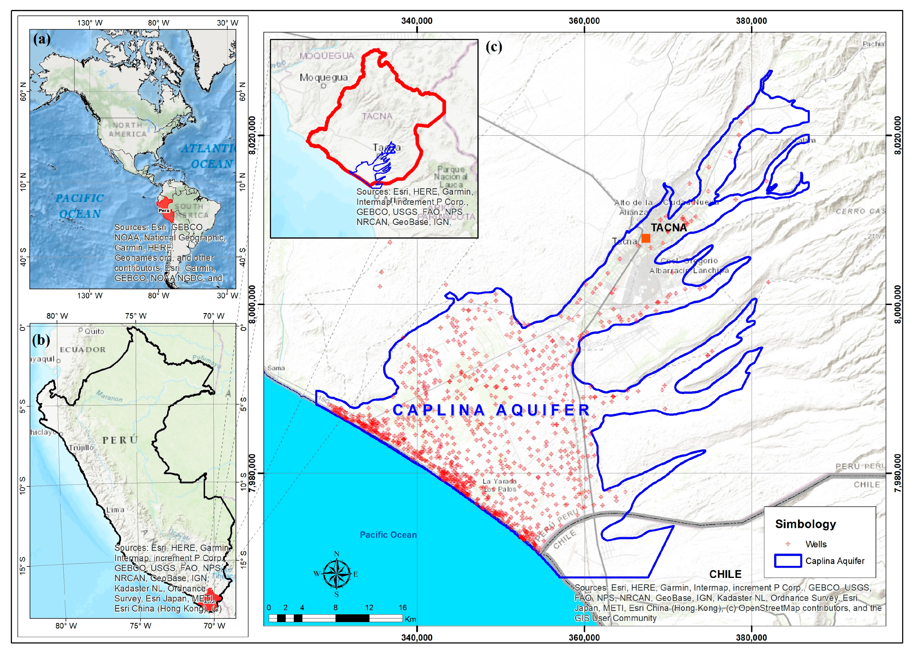
2. Study Area
3. Materials and Methods
3.1. Peruvian Water Resources Law
3.2. Management Instruments
3.3. Scientific Evidence Results
3.4. Conflicting Users
4. Results and Discussion
4.1. On the Instruments of Management and Public Policy
4.2. About the Results of Scientific Evidence
4.3. Management, Public Policy, and Science Results
5. Conclusions
Author Contributions
Funding
Data Availability Statement
Acknowledgments
Conflicts of Interest
References
- Vansteenbergen, F.; Oliemans, W. A Review of Policies in Groundwater Management in Pakistan 1950–2000. Water Policy 2002, 4, 323–344. [Google Scholar] [CrossRef]
- Qureshi, A.S. Groundwater Governance in Pakistan: From Colossal Development to Neglected Management. Water 2020, 12, 3017. [Google Scholar] [CrossRef]
- Guilfoos, T.; Khanna, N.; Peterson, J.M. Efficiency of Viable Groundwater Management Policies. Land Econ. 2016, 92, 618–640. [Google Scholar] [CrossRef]
- Mekonnen, M.M.; Hoekstra, A.Y. Four Billion People Facing Severe Water Scarcity. Sci. Adv. 2016, 2, 2. [Google Scholar] [CrossRef] [PubMed]
- Burstein-Roda, T. Reflexiones Sobre La Gestión de Los Recursos Hídricos y La Salud Pública En El Perú. Rev. Peru. Med. Exp. Salud Publica 2018, 35, 297. [Google Scholar] [CrossRef] [PubMed][Green Version]
- Zheng, C.; Spijkers, O. Priority of Uses in International Water Law. Sustainability 2021, 13, 1567. [Google Scholar] [CrossRef]
- Navarro, N.; Abad, M.; Bonnail, E.; Izquierdo, T. The Arid Coastal Wetlands of Northern Chile: Towards an Integrated Management of Highly Threatened Systems. J. Mar. Sci. Eng. 2021, 9, 948. [Google Scholar] [CrossRef]
- Robertson, J. The Common Pool Resource Heatmap: A Tool to Drive Changes in Water Law and Governance. Water 2021, 13, 3110. [Google Scholar] [CrossRef]
- Hamed, Y.; Houda, B.; Ahmed, M.; Hadji, R.; Ncibi, K. North Western Sahara Aquifer System Hydrothermal and Petroleum Reservoirs Dynamics: A Comprehensive Overview. Arab. J. Geosci. 2023, 16, 247. [Google Scholar] [CrossRef]
- Hamed, Y.; Hadji, R.; Ncibi, K.; Hamad, A.; Ben Sâad, A.; Melki, A.; Khelifi, F.; Mokadem, N.; Mustafa, E. Modelling of Potential Groundwater Artificial Recharge in the Transboundary Algero-Tunisian Basin (Tebessa-Gafsa): The Application of Stable Isotopes and Hydroinformatics Tools *. Irrig. Drain. 2022, 71, 137–156. [Google Scholar] [CrossRef]
- Hamad, A.; Abdeslam, I.; Fehdi, C.; Badreddine, S.; Mokadem, N.; Legrioui, R.; Djebassi, T.; Rahal, O.; Hadji, R.; Hamed, Y. Vulnerability Characterization for Multi-Carbonate Aquifer Systems in Semiarid Climate, Case of Algerian–Tunisian Transboundary Basin. Int. J. Energy Water Resour. 2022, 6, 67–80. [Google Scholar] [CrossRef]
- Starke, J.R.; Van Rijswick, H.F.M.W. Exemptions of the EU Water Framework Directive Deterioration Ban: Comparing Implementation Approaches in Lower Saxony and The Netherlands. Sustainability 2021, 13, 930. [Google Scholar] [CrossRef]
- Mostert, E. Law and Politics in River Basin Management: The Implementation of the Water Framework Directive in The Netherlands. Water 2020, 12, 3367. [Google Scholar] [CrossRef]
- Goytia, S. Issues of Natural Resources Law for Adopting Catchment-Based Measures for Flood Risk Management in Sweden. Sustainability 2021, 13, 2072. [Google Scholar] [CrossRef]
- Meehan, K. Water Justice and the Law in Latin America. Lat. Am. Res. Rev. 2019, 54, 517–523. [Google Scholar] [CrossRef][Green Version]
- LaVanchy, G.; Romano, S.; Taylor, M. Challenges to Water Security along the “Emerald Coast”: A Political Ecology of Local Water Governance in Nicaragua. Water 2017, 9, 655. [Google Scholar] [CrossRef]
- Prieto, M. Equity vs. Efficiency and the Human Right to Water. Water 2021, 13, 278. [Google Scholar] [CrossRef]
- Sindico, F.; Hirata, R.; Manganelli, A. The Guarani Aquifer System: From a Beacon of Hope to a Question Mark in the Governance of Transboundary Aquifers. J. Hydrol. Reg. Stud. 2018, 20, 49–59. [Google Scholar] [CrossRef]
- Hatch Kuri, G. Groundwater and Interdependent Sovereignty: The Case of the Transborder Aquifer Systems in the Paso Del Norte Binational Region. Norteamérica 2017, 12, 113–145. [Google Scholar] [CrossRef]
- Hatch Kuri, G.; Carrillo Rivera, J.J. Conceptos Científicos y Sus Implicaciones Políticas En La Gestión de Las Aguas Transfronterizas México-Estados Unidos: ¿Acuífero Transfronterizo o Aguas Subterráneas Transfronterizas? Agua Territ./Water Landsc. 2022, 21, 1–16. [Google Scholar] [CrossRef]
- Elshall, A.S.; Arik, A.D.; El-Kadi, A.I.; Pierce, S.; Ye, M.; Burnett, K.M.; Wada, C.A.; Bremer, L.L.; Chun, G. Groundwater Sustainability: A Review of the Interactions between Science and Policy. Environ. Res. Lett. 2020, 15, 093004. [Google Scholar] [CrossRef]
- Owen, D.; Cantor, A.; Nylen, N.G.; Harter, T.; Kiparsky, M. California Groundwater Management, Science-Policy Interfaces, and the Legacies of Artificial Legal Distinctions. Environ. Res. Lett. 2019, 14, 045016. [Google Scholar] [CrossRef]
- Petersen-Perlman, J.D.; Aguilar-Barajas, I.; Megdal, S.B. Drought and Groundwater Management: Interconnections, Challenges, and Policyresponses. Curr. Opin. Environ. Sci. Health 2022, 28, 100364. [Google Scholar] [CrossRef]
- Engler, A.; Melo, O.; Rodríguez, F.; Peñafiel, B.; Jara-Rojas, R. Governing Water Resource Allocation: Water User Association Characteristics and the Role of the State. Water 2021, 13, 2436. [Google Scholar] [CrossRef]
- Díaz-Campos, K.A. Crisis Del Agua En El Norte de Chile. Derecho y Cultura En Los Andes. Sobre Los Efectos Irracionales Del Derecho. Diálogo Andin. 2020, 61, 67–79. [Google Scholar] [CrossRef]
- Manríquez Tirado, H.; Mansilla Quiñones, P.; Moreira Muñoz, A. Hacia Una Conservación Integrada Del Paisaje Biogeocultural de Atacama. Diálogo Andin. 2019, 60, 141–152. [Google Scholar] [CrossRef]
- Rodríguez Valdivia, A.; Albornoz Espinoza, C.; Tapia Tosetti, A. Geomorfología Del Área de Putre, Andes Del Norte de Chile: Acción Volcánica y Climática En Su Modelado. Diálogo Andin. 2017, 54, 7–20. [Google Scholar] [CrossRef]
- Mendez, M.; Prieto, M.; Godoy, M. Production of Subterranean Resources in the Atacama Desert: 19th and Early 20th Century Mining/Water Extraction in The Taltal District, Northern Chile. Polit. Geogr. 2020, 81, 102194. [Google Scholar] [CrossRef]
- Chucuya, S.; Vera, A.; Pino-Vargas, E.; Steenken, A.; Mahlknecht, J.; Montalván, I. Hydrogeochemical Characterization and Identification of Factors Influencing Groundwater Quality in Coastal Aquifers, Case: La Yarada, Tacna, Peru. Int. J. Environ. Res. Public Health 2022, 19, 2815. [Google Scholar] [CrossRef]
- Condori Tintaya, F.; Pino Vargas, E.; Tacora Villegas, P. Pérdida de Suelos Por Erosión Hídrica En Laderas Semiáridas de La Subcuenca Cairani-Camilaca, Perú. Idesia 2022, 40, 7–15. [Google Scholar] [CrossRef]
- Narvaez-Montoya, C.; Torres-Martínez, J.A.; Pino-Vargas, E.; Cabrera-Olivera, F.; Loge, F.J.; Mahlknecht, J. Predicting Adverse Scenarios for a Transboundary Coastal Aquifer System in the Atacama Desert (Peru/Chile). Sci. Total Environ. 2022, 806, 150386. [Google Scholar] [CrossRef]
- Gamboa, C.; Godfrey, L.; Urrutia, J.; Herrera, C.; Lu, X.; Jordan, T. Conditions of Groundwater Recharge in the Hyperarid Southern Atacama Desert. Glob. Planet. Chang. 2022, 217, 103931. [Google Scholar] [CrossRef]
- Pino, E.; Ramos, L.; Mejía, J.; Chávarri, E.; Ascensios, D. Medidas de Mitigación Para El Acuífero Costero La Yarada, Un Sistema Sobreexplotado En Zonas Áridas. Idesia 2020, 38, 21–31. [Google Scholar] [CrossRef]
- Pino-Vargas, E.; Ascencios-Templo, D. La Implementación de Veda Como Una Herramienta Para Controlar La Degradación Del Acuífero Costero La Yarada, Tacna, Perú. Diálogo Andin. 2021, 66, 489–496. [Google Scholar] [CrossRef]
- Vera, A.; Pino-Vargas, E.; Verma, M.P.; Chucuya, S.; Chávarri, E.; Canales, M.; Torres-Martínez, J.A.; Mora, A.; Mahlknecht, J. Hydrodynamics, Hydrochemistry, and Stable Isotope Geochemistry to Assess Temporal Behavior of Seawater Intrusion in the La Yarada Aquifer in the Vicinity of Atacama Desert, Tacna, Peru. Water 2021, 13, 3161. [Google Scholar] [CrossRef]
- Pino, E.; Ramos, L.; Avalos, O.; Tacora, P.; Chávarri, E.; Angulo, O.; Ascensios, D.; Mejía, J. Factores Que Inciden En El Agotamiento y La Contaminación Por Intrusión Marina En El Acuífero Costero de La Yarada, Tacna, Perú. Tecnol. Cienc. Agua 2019, 10, 177–213. [Google Scholar] [CrossRef]
- Pino, V.E.; Chávarri, V.E.; Ramos, F.L. Crisis de Gobernanza y Gobernabilidad y Sus Implicancias En El Uso Inadecuado Del Agua Subterránea, Caso Acuífero Costero de La Yarada, Tacna, Perú. Idesia 2018, 36, 77–85. [Google Scholar] [CrossRef]
- Pino, E. Conflicts over the Use of Water in an Arid Region: Case of Tacna, Peru. Diálogo Andin. 2021, 65, 406–415. [Google Scholar]
- Pocco, V.; Chucuya, S.; Huayna, G.; Ingol-Blanco, E.; Pino-Vargas, E. A Multi-Criteria Decision-Making Technique Using Remote Sensors to Evaluate the Potential of Groundwater in the Arid Zone Basin of the Atacama Desert. Water 2023, 15, 1344. [Google Scholar] [CrossRef]
- Pino-Vargas, E.; Chávarri-Velarde, E.; Ingol-Blanco, E.; Mejía, F.; Cruz, A.; Vera, A. Impacts of Climate Change and Variability on Precipitation and Maximum Flows in Devil’s Creek, Tacna, Peru. Hydrology 2022, 9, 10. [Google Scholar] [CrossRef]
- Pino-Vargas, E.; Taya-Acosta, E.; Ingol-Blanco, E.; Torres-Rúa, A. Deep Machine Learning for Forecasting Daily Potential Evapotranspiration in Arid Regions, Case: Atacama Desert Header. Agriculture 2022, 12, 1971. [Google Scholar] [CrossRef]
- Vera, A.; Verma, M.P.; Pino-Vargas, E.; Huayna, G. Metodología de Ponderación Morfométrica e Hidrogeoquímica Para Clasificar La Susceptibilidad a La Meteorización Química En Las Subcuencas Del Río Caplina, Tacna, Perú. Tecnol. Cienc. Agua 2022, 13, 276–340. [Google Scholar] [CrossRef]
- Pino, E. El Acuífero Costero La Yarada, Después de 100 Años de Explotación Como Sustento de Una Agricultura En Zonas Áridas: Una Revisión Histórica. Idesia 2019, 37, 39–45. [Google Scholar] [CrossRef]
- Houston, J.; Hartley, A.J. The Central Andean West-Slope Rainshadow and Its Potential Contribution to the Origin of Hyper-Aridity in the Atacama Desert. Int. J. Climatol. 2003, 23, 1453–1464. [Google Scholar] [CrossRef]
- Pino-Vargas, E.; Huayna, G. Spatial and Temporal Evolution of Olive Cultivation Due to Pest Attack, Using Remote Sensing and Satellite Image Processing. Sci. Agropecu. 2022, 13, 149–157. [Google Scholar] [CrossRef]
- Peña, F.; Cotrina, G.; Acosta, H. Hidrogeología de La Cuenca Del Río Caplina—Región Tacna—[Boletín H 1]. Inst. Geol. Min. Met. INGEMMET 2009, 1, 141. [Google Scholar]
- Machaca-Pillaca, R.; Pino-Vargas, E.; Ramos-Fernández, L.; Quille-Mamani, J.; Torres-Rua, A. Estimación de La Evapotranspiración Con Fines de Riego En Tiempo Real de Un Olivar a Partir de Imágenes de Un Drone En Zonas Áridas, Caso La Yarada, Tacna, Perú. Idesia Arica 2022, 40, 55–65. [Google Scholar] [CrossRef]
- Ritter, B.; Wennrich, V.; Medialdea, A.; Brill, D.; King, G.; Schneiderwind, S.; Niemann, K.; Fernández-Galego, E.; Diederich, J.; Rolf, C.; et al. Climatic Fluctuations in the Hyperarid Core of the Atacama Desert during the Past 215 Ka. Sci. Rep. 2019, 9, 5270. [Google Scholar] [CrossRef]
- Houston, J. Variability of Precipitation in the Atacama Desert: Its Causes and Hydrological Impact. Int. J. Climatol. 2006, 26, 2181–2198. [Google Scholar] [CrossRef]
- Garreaud, R.D.; Molina, A.; Farias, M. Andean Uplift, Ocean Cooling and Atacama Hyperaridity: A Climate Modeling Perspective. Earth Planet. Sci. Lett. 2010, 292, 39–50. [Google Scholar] [CrossRef]
- Garreaud, R.D.; Vuille, M.; Compagnucci, R.; Marengo, J. Present-Day South American Climate. Palaeogeogr. Palaeoclimatol. Palaeoecol. 2009, 281, 180–195. [Google Scholar] [CrossRef]
- Garreaud, R.; Vuille, M.; Clement, A.C. The Climate of the Altiplano: Observed Current Conditions and Mechanisms of Past Changes. Palaeogeogr. Palaeoclimatol. Palaeoecol. 2003, 194, 5–22. [Google Scholar] [CrossRef]
- Pino Vargas, E.M.; Ascencios, D.R. Sostenibilidad Del Cultivo de Olivo Bajo Un Enfoque Climatológico En Una Región Árida, Cabecera Del Desierto de Atacama. Cienc. Tecnol. Agropecu. 2022, 23, 3. [Google Scholar] [CrossRef]
- Pino, V.E.; Chávarri, V.E. Evidencias de Cambio Climático En La Región Hiperárida de La Costa Sur de Perú, Cabecera Del Desierto de Atacama. Tecnol. Cienc. Agua 2022, 13, 1–34. [Google Scholar]
- Espinoza-Molina, J.; Acosta-Caipa, K.; Chambe-Vega, E.; Huayna, G.; Pino-Vargas, E.; Abad, J. Spatiotemporal Analysis of Urban Heat Islands in Relation to Urban Development, in the Vicinity of the Atacama Desert. Climate 2022, 10, 87. [Google Scholar] [CrossRef]
- Tapsuwan, S.; Peña-Arancibia, J.L.; Lazarow, N.; Albisetti, M.; Zheng, H.; Rojas, R.; Torres-Alferez, V.; Chiew, F.H.S.; Hopkins, R.; Penton, D.J. A Benefit Cost Analysis of Strategic and Operational Management Options for Water Management in Hyper-Arid Southern Peru. Agric. Water Manag. 2022, 265, 107518. [Google Scholar] [CrossRef]
- Pino-Vargas, E.; Guevara-Pérez, E.; Avendaño-Jihuallanga, C. Evolución Histórica de La Conceptualización Hidrogeológica y Del Uso Del Acuífero Caplina Ubicado En El Borde Norte Del Desierto de Atacama. Rev. Ing. UC 2021, 28, 378–391. [Google Scholar] [CrossRef]
- Pino, E. Sobreexplotación Del Agua Subterránea y La Agroexportación En El Acuífero Costero de La Yarada, Tacna, Perú. Agric. Soc. Desarro. 2021, 18, 247–258. [Google Scholar]
- Viguier, B.; Jourde, H.; Leonardi, V.; Daniele, L.; Batiot-Guilhe, C.; Favreau, G.; De Montety, V. Water Table Variations in the Hyperarid Atacama Desert: Role of the Increasing Groundwater Extraction in the Pampa Del Tamarugal (Northern Chile). J. Arid Environ. 2019, 168, 9–16. [Google Scholar] [CrossRef]
- Pino-Vargas, E. Water Security in the La Yarada Coastal Aquifer: Current and Future Challenges. Agroindustrial Sci. 2019, 9, 219–225. [Google Scholar] [CrossRef]
- Pino-Vargas, E.; Montalvan-Díaz, I.; Avendaño-Jihuallanga, C. Future Water Availability in Dryland Ecosystems in Southern Peru and Northern Chile. Agroind. Sci. 2019, 9, 173–178. [Google Scholar] [CrossRef]
- Viguier, B.; Jourde, H.; Yáñez, G.; Lira, E.S.; Leonardi, V.; Moya, C.E.; García-Pérez, T.; Maringue, J.; Lictevout, E. Multidisciplinary Study for the Assessment of the Geometry, Boundaries and Preferential Recharge Zones of an Overexploited Aquifer in the Atacama Desert (Pampa Del Tamarugal, Northern Chile). J. S. Am. Earth Sci. 2018, 86, 366–383. [Google Scholar] [CrossRef]
- Pino, V.E. Caracterización Hidrogeológica Para Determinar El Deterioro de La Calidad Del Agua En El Acuifero La Yarada Media. Rev. Investig. Altoandinas J. High Andean Res. 2018, 20, 477–490. [Google Scholar] [CrossRef]
- Pino, E.; Tacora, P.; Steenken, A.; Alfaro, L.; Valle, A.; Chávarri, E.; Ascencios, D.; Mejía Marcacuzco, J. Effect of Environmental and Geological Characteristics on Water Quality in the Caplina River Basin, Tacna, Peru. Tecnol. y Cienc. del Agua 2017, 8, 77–99. [Google Scholar] [CrossRef]
- Azua-Bustos, A.; Fairén, A.G.; González-Silva, C.; Ascaso, C.; Carrizo, D.; Fernández-Martínez, M.Á.; Fernández-Sampedro, M.; García-Descalzo, L.; García-Villadangos, M.; Martin-Redondo, M.P.; et al. Unprecedented Rains Decimate Surface Microbial Communities in the Hyperarid Core of the Atacama Desert. Sci. Rep. 2018, 8, 16706. [Google Scholar] [CrossRef] [PubMed]
- Huggel, C.; Scheel, M.; Albrecht, F.; Andres, N.; Calanca, P.; Jurt, C.; Khabarov, N.; Mira-Salama, D.; Rohrer, M.; Salzmann, N.; et al. A Framework for the Science Contribution in Climate Adaptation: Experiences from Science-Policy Processes in the Andes. Environ. Sci. Policy 2015, 47, 80–94. [Google Scholar] [CrossRef]
- Vaux, H. Groundwater under Stress: The Importance of Management. Environ. Earth Sci. 2011, 62, 19–23. [Google Scholar] [CrossRef]
- Zeinali, M.; Bozorg-Haddad, O.; Azamathulla, H.M. Water Policy and Governance. In Economical, Political, and Social Issues in Water Resources; Elsevier: Amsterdam, The Netherlands, 2021; pp. 129–153. [Google Scholar]


| Instrument | Institution, Year, Scale of Application | Scopes |
|---|---|---|
| Supreme Decree No. 080-84-AG | MINAGRI, 1984, Local | The underground waters of the La Yarada pampas were reserved for two years |
| Supreme Decree No. 020-87-AG | MINAGRI, 1987, Local | An extension is given for two more years for the groundwater reserve in the pampas of La Yarada |
| Ministerial Resolution N° 0555-89-AG/DGAS del | MINAGRI, 1989, Local | The execution of works intended to extract groundwater in the pampas of La Yarada is prohibited |
| Ministerial Resolution N° 696-98-AG | MINAGRI, 1998, Local | The ban is declared on the increase in the exploitation of groundwater in the aquifer |
| Constitutional Court ruling N° 1290–2002-AC/TC | TC, 2003, Local | It ruled on the declaration of closure and the non-application of regulations for the regularization of water licenses in the area declared closed |
| Regional Ordinance N° 009-2004-CR/ GOB.REG.TACNA | GORE, 2004, Local | Declared regional interest in the intangibility and conservation of groundwater and uncultivated land in the state of Las Pampas from La Yarada |
| Supreme Decree N° 065-2006-AG | MINAGRI, 2006, Local | The conservation and preservation of the water resources of the Caplina Valley are declared of public necessity and national interest, extending the ban to the entire Caplina aquifer |
| Water Resources Law, Law N° 29338 | MINAGRI, 2009, National | Regulates the use and management of water resources and includes surface, underground, and continental water and the assets associated with it and extends to maritime and atmospheric water as applicable |
| Chief Resolution N° 327-2009-ANA | ANA, 2009, Local | The declaration of a ban on the aquifer of the Caplina River valley, which includes the La Yarada aquifer, is ratified; the prohibition of the execution of groundwater exploitation works |
| Regulation of the Law N° 29338 | MINAGRI, 2010, National | The purpose of the Regulation is to regulate the use and management of water resources, as well as the actions of the State and individuals in said management, all by the provisions contained in the Water Resources Law, Law No. 29338 |
| Chief Resolution N° 201-2010-ANA | ANA, 2010, Local | Ratifies the measures for the conservation and preservation of groundwater, based on the study “Numerical Modeling of the La Yarada Aquifer”, which concludes that there is overexploitation of the aquifer and recommends maintaining the ban on the exploitation of the system |
| Supreme Decree N° 007-2015-MINAGRI | MINAGRI, 2015, National | The areas declared “closed season” maintain their condition, proceeding exceptionally and only once to formalize or regularize the water use licenses |
| Article | Journal, Year | Reference |
|---|---|---|
| A Multi-Criteria Decision-Making Technique Using Remote Sensors to Evaluate the Potential of Groundwater in the Arid Zone Basin of the Atacama Desert. | Water, 2023 | [39] |
| Spatiotemporal Analysis of Urban Heat Islands about Urban Development, in the Vicinity of the Atacama Desert. | Climate, 2022 | [55] |
| Sustainability of olive cultivation under a climatic approach in an arid region, head of the Atacama Desert. | Ciencia y Tecnología Agropecuaria, 2022 | [53] |
| Deep Machine Learning for Forecasting Daily Potential Evapotranspiration in Arid Regions, Case: Atacama Desert Header. | Agriculture, 2022 | [41] |
| Morphometric and Hydrogeochemical Weighting Methodology to Classify Susceptibility to Chemical Weathering in the Sub-basins of the Caplina River, Tacna, Peru. | Tecnología y ciencias del agua, 2022 | [42] |
| Spatial and temporal evolution of olive cultivation due to pest attack, using remote sensing and satellite image processing. | Scientia Agropecuaria, 2022 | [45] |
| Hydrogeochemical Characterization and Identification of Factors Influencing Groundwater Quality in Coastal Aquifers, Case: La Yarada, Tacna, Peru. | Int. J. Environ. Res. Public Health, 2022 | [29] |
| Predicting adverse scenarios for a transboundary coastal aquifer system in the Atacama Desert (Peru/Chile). | Science of The Total Environment, 2022 | [31] |
| Impacts of Climate Change and Variability on Precipitation and Maximum Flows in Devil’s Creek, Tacna, Peru. | Hydrology, 2022 | [40] |
| Evidence of climate change in the hyperarid region of the southern coast of Peru, head of the Atacama Desert. | Tecnología y Ciencias Del Agua, 2022 | [54] |
| A benefit cost analysis of strategic and operational management options for water management in hyper-arid southern Peru. | Agricultural Water Management, 2022 | [56] |
| The implementation of the ban as a tool to control the degradation of the La Yarada coastal aquifer, Tacna, Peru. | Diálogo Andino, 2021 | [34] |
| Conflicts over the use of water in an arid region: Tacna Case, Peru. | Diálogo Andino, 2021 | [38] |
| Hydrodynamics, Hydrochemistry, and Stable Isotope Geochemistry to Assess Temporal Behavior of Seawater Intrusion in the La Yarada Aquifer in the Vicinity of Atacama Desert, Tacna, Peru. | Water, 2021 | [35] |
| Historical evolution of the hydrogeological conceptualization and use of the Caplina aquifer located on the northern edge of the Atacama Desert. | Revista Ingeniería UC, 2021 | [57] |
| Overexploitation of groundwater and agro-export in the Yarada coastal aquifer, Tacna, Peru. | Agricultura Sociedad Y Desarrollo, 2021 | [58] |
| Mitigation measures for the La Yarada coastal aquifer, an overexploited system in arid zones. | Idesia, 2020 | [33] |
| Production of subterranean resources in the Atacama Desert: 19th and early 20th century mining/water extraction in The Taltal district, northern Chile | Political Geography, 2020 | [28] |
| A benefit cost analysis of strategic and operational management options for water management in hyper-arid southern Peru | Agricultural Water Management, 2022 | [59] |
| Factors that affect the depletion and contamination by marine intrusion in the coastal aquifer of La Yarada, Tacna, Peru. | Tecnología y ciencias del agua, 2019 | [36] |
| The La Yarada coastal aquifer, after 100 years of exploitation as a livelihood for agriculture in arid zones: A historical review. | Idesia, 2019 | [43] |
| Water security in the La Yarada coastal aquifer: Current and future challenges. | Agroindustrial Science, 2019 | [60] |
| Future water availability in arid zone ecosystems in southern Peru and northern Chile. | Agroindustrial Science, 2019 | [61] |
| Multidisciplinary study for the assessment of the geometry, boundaries, and preferential recharge zones of an overexploited aquifer in the Atacama Desert (Pampa del Tamarugal, Northern Chile) | Journal of South American Earth Sciences, 2018 | [62] |
| Governance and governability crisis and its implications for the inappropriate use of groundwater, coastal aquifer case of La Yarada, Tacna, Peru. | Idesia, 2018 | [35] |
| Hydrogeological characterization to determine the deterioration of water quality in the La Yarada Media aquifer. | Journal of High Andean Research, 2018 | [63] |
| Effect of environmental and geological characteristics on water quality in the Caplina River basin, Tacna, Peru. | Tecnología y ciencias del agua, 2017 | [64] |
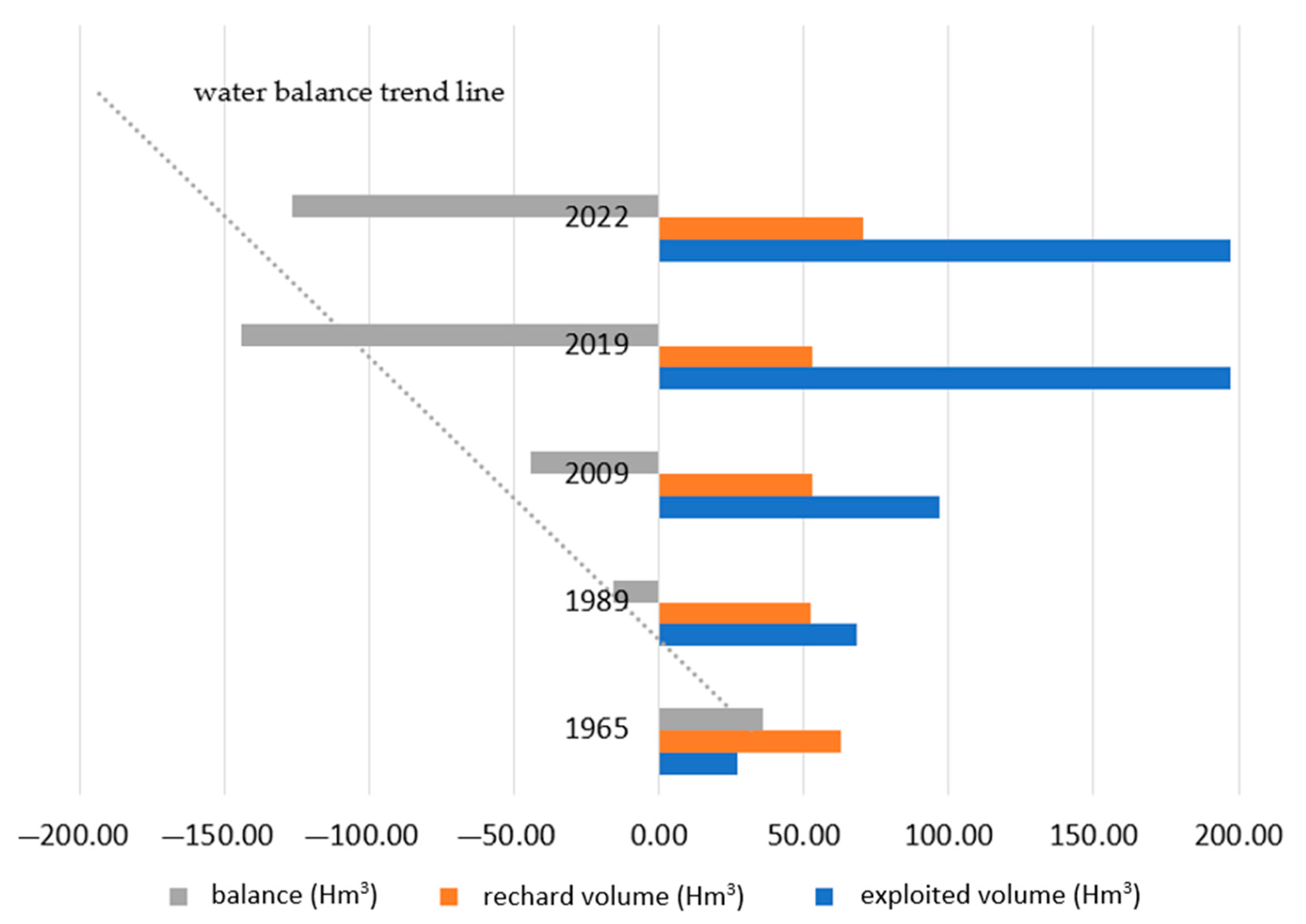
| Year | 1965 | 1989 | 2009 | 2019 | 2022 |
|---|---|---|---|---|---|
| exploited volume (Hm3) | 27.0 | 68.0 | 97.0 | 197.1 | 197.1 |
| recharge volume (Hm3) | 63.0 | 52.5 | 53.0 | 53.0 | 70.6 |
| balance (Hm3) | 36.0 | −15.5 | −44.0 | −144.1 | −126.5 |
| institution | INIFM | PET-INADE | INGEMMET | ANA | ANA |
Disclaimer/Publisher’s Note: The statements, opinions and data contained in all publications are solely those of the individual author(s) and contributor(s) and not of MDPI and/or the editor(s). MDPI and/or the editor(s) disclaim responsibility for any injury to people or property resulting from any ideas, methods, instructions or products referred to in the content. |
© 2023 by the authors. Licensee MDPI, Basel, Switzerland. This article is an open access article distributed under the terms and conditions of the Creative Commons Attribution (CC BY) license (https://creativecommons.org/licenses/by/4.0/).
Share and Cite
Pino-Vargas, E.; Espinoza-Molina, J.; Chávarri-Velarde, E.; Quille-Mamani, J.; Ingol-Blanco, E. Impacts of Groundwater Management Policies in the Caplina Aquifer, Atacama Desert. Water 2023, 15, 2610. https://doi.org/10.3390/w15142610
Pino-Vargas E, Espinoza-Molina J, Chávarri-Velarde E, Quille-Mamani J, Ingol-Blanco E. Impacts of Groundwater Management Policies in the Caplina Aquifer, Atacama Desert. Water. 2023; 15(14):2610. https://doi.org/10.3390/w15142610
Chicago/Turabian StylePino-Vargas, Edwin, Jorge Espinoza-Molina, Eduardo Chávarri-Velarde, Javier Quille-Mamani, and Eusebio Ingol-Blanco. 2023. "Impacts of Groundwater Management Policies in the Caplina Aquifer, Atacama Desert" Water 15, no. 14: 2610. https://doi.org/10.3390/w15142610
APA StylePino-Vargas, E., Espinoza-Molina, J., Chávarri-Velarde, E., Quille-Mamani, J., & Ingol-Blanco, E. (2023). Impacts of Groundwater Management Policies in the Caplina Aquifer, Atacama Desert. Water, 15(14), 2610. https://doi.org/10.3390/w15142610