
Inundation Analysis of Coastal Urban Area under Climate Change Scenarios


Abstract
1. Introduction
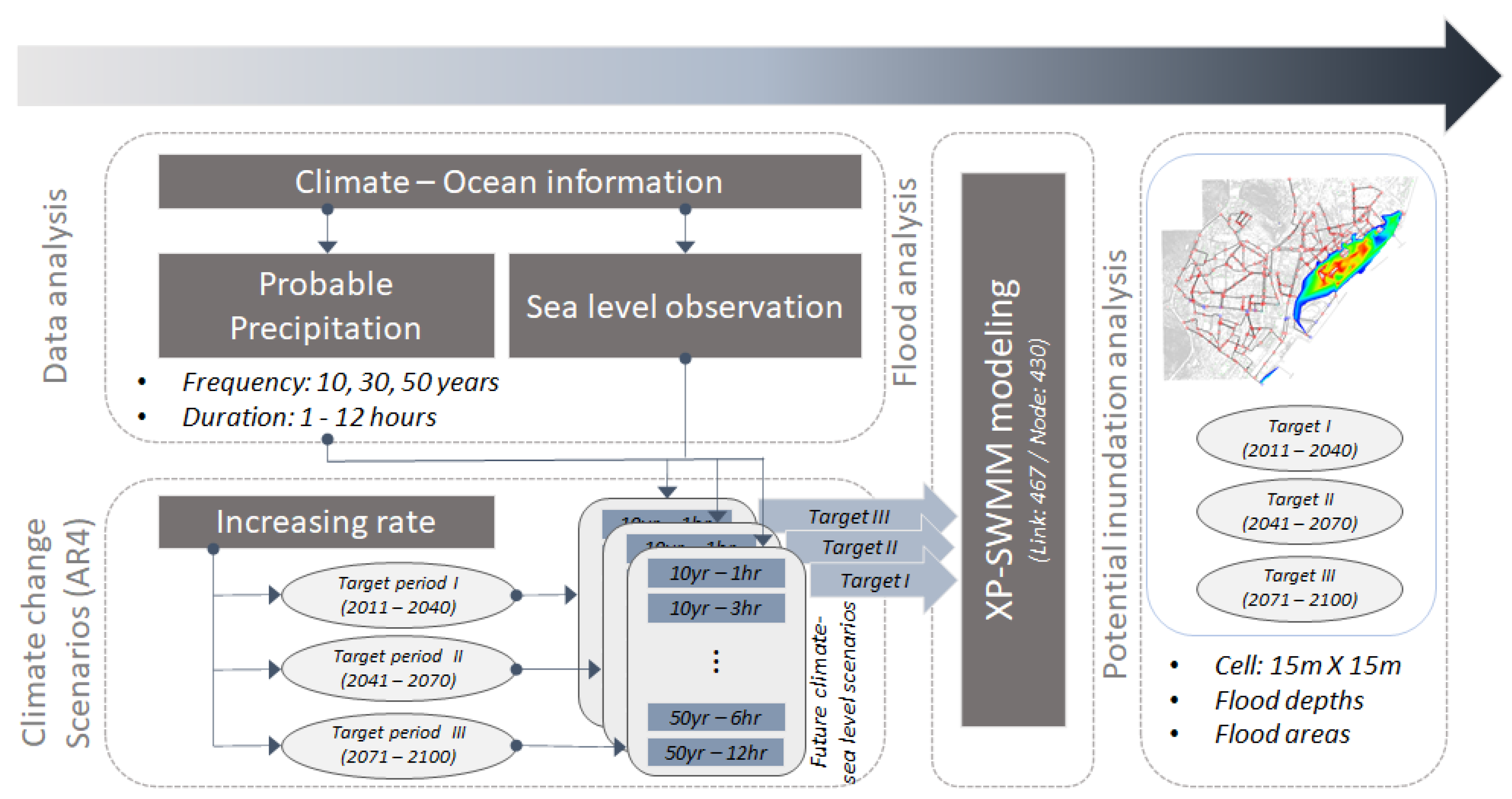
2. Materials and Methods
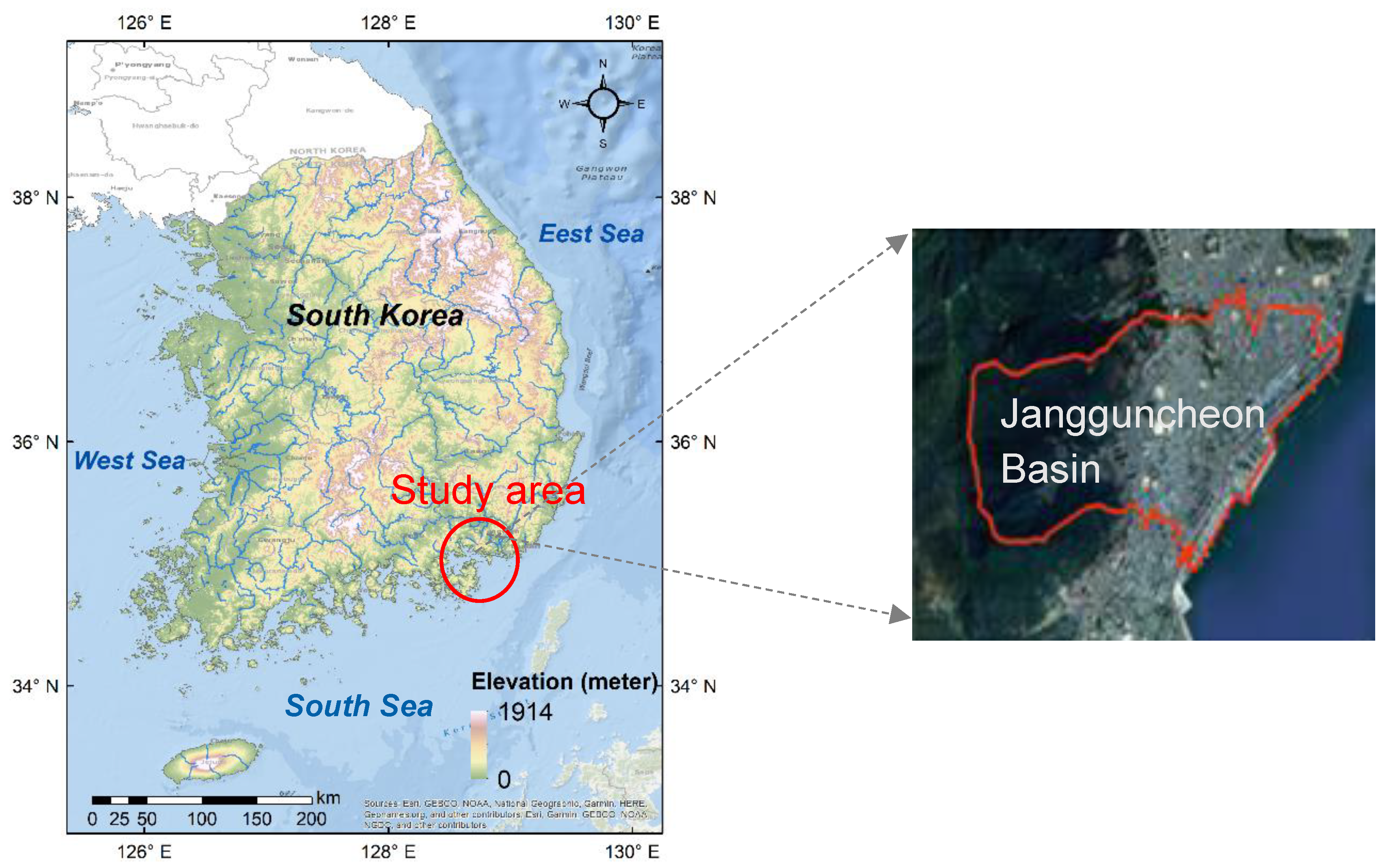
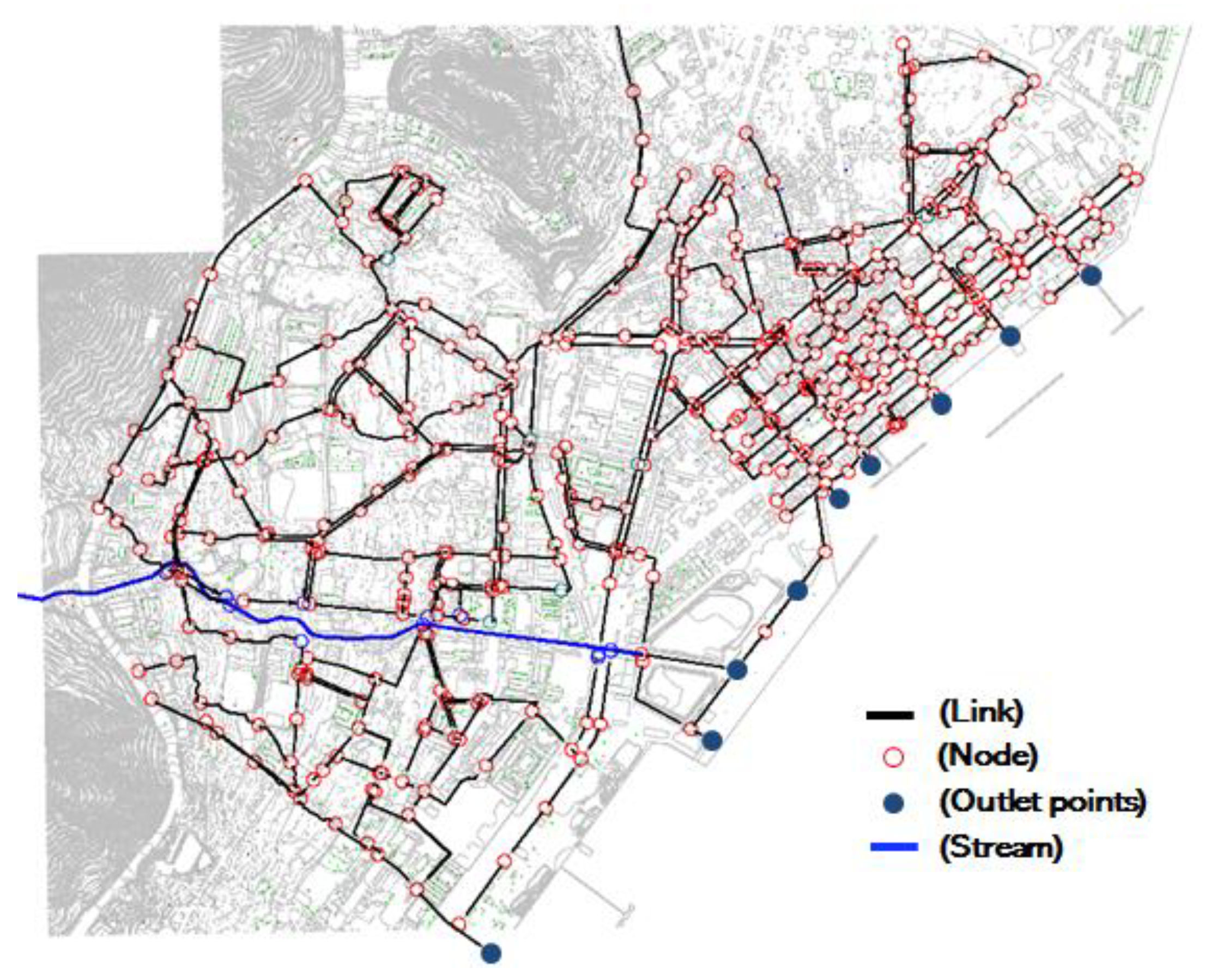
2.1. Study Area and Datasets
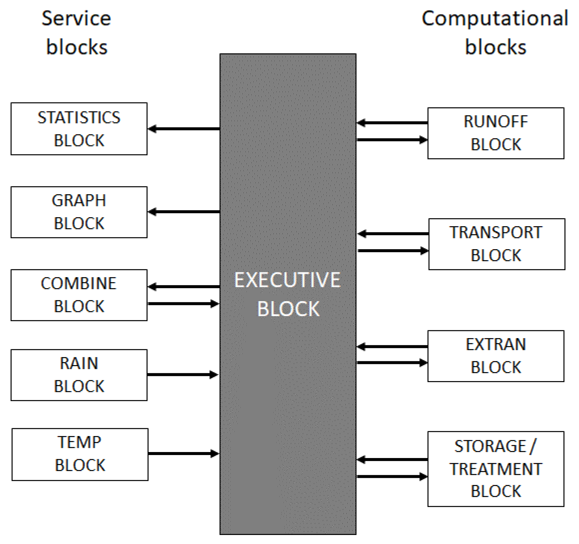
2.2. SWMM Model
2.3. Climate Change Scenario
2.4. Potential Probable Precipitation with Climate Change Scenario
2.5. Potential Sea-Level Rise with Climate Change Scenario
3. Results
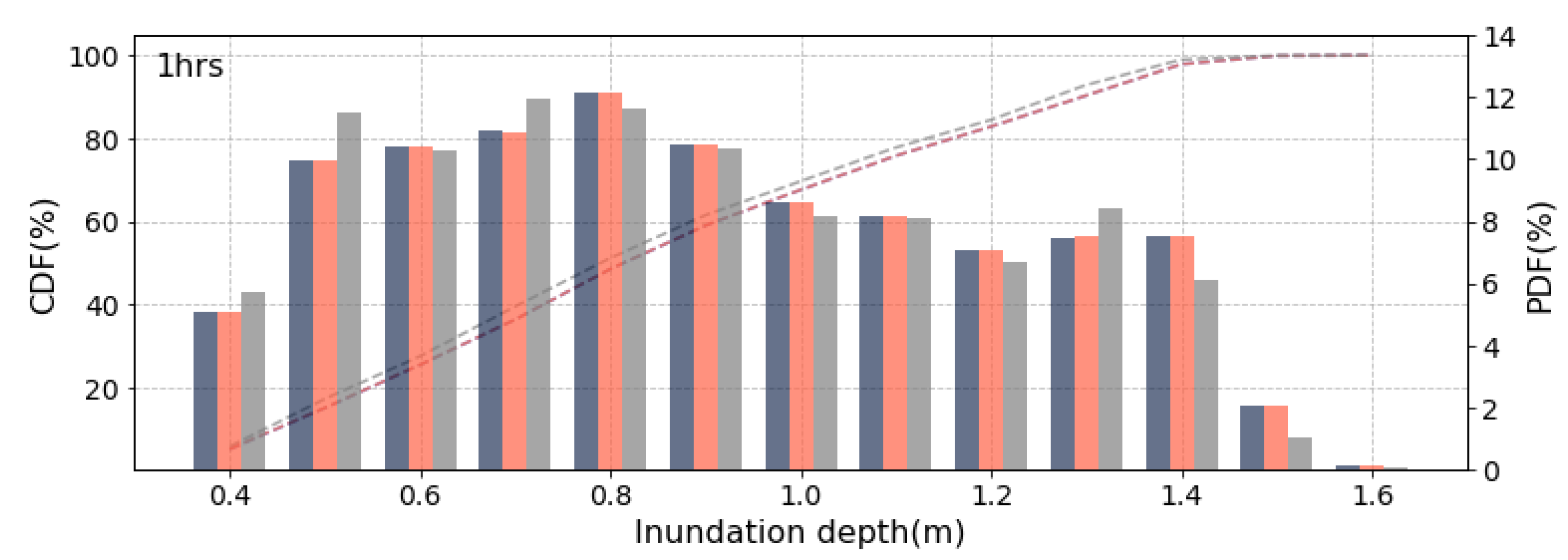
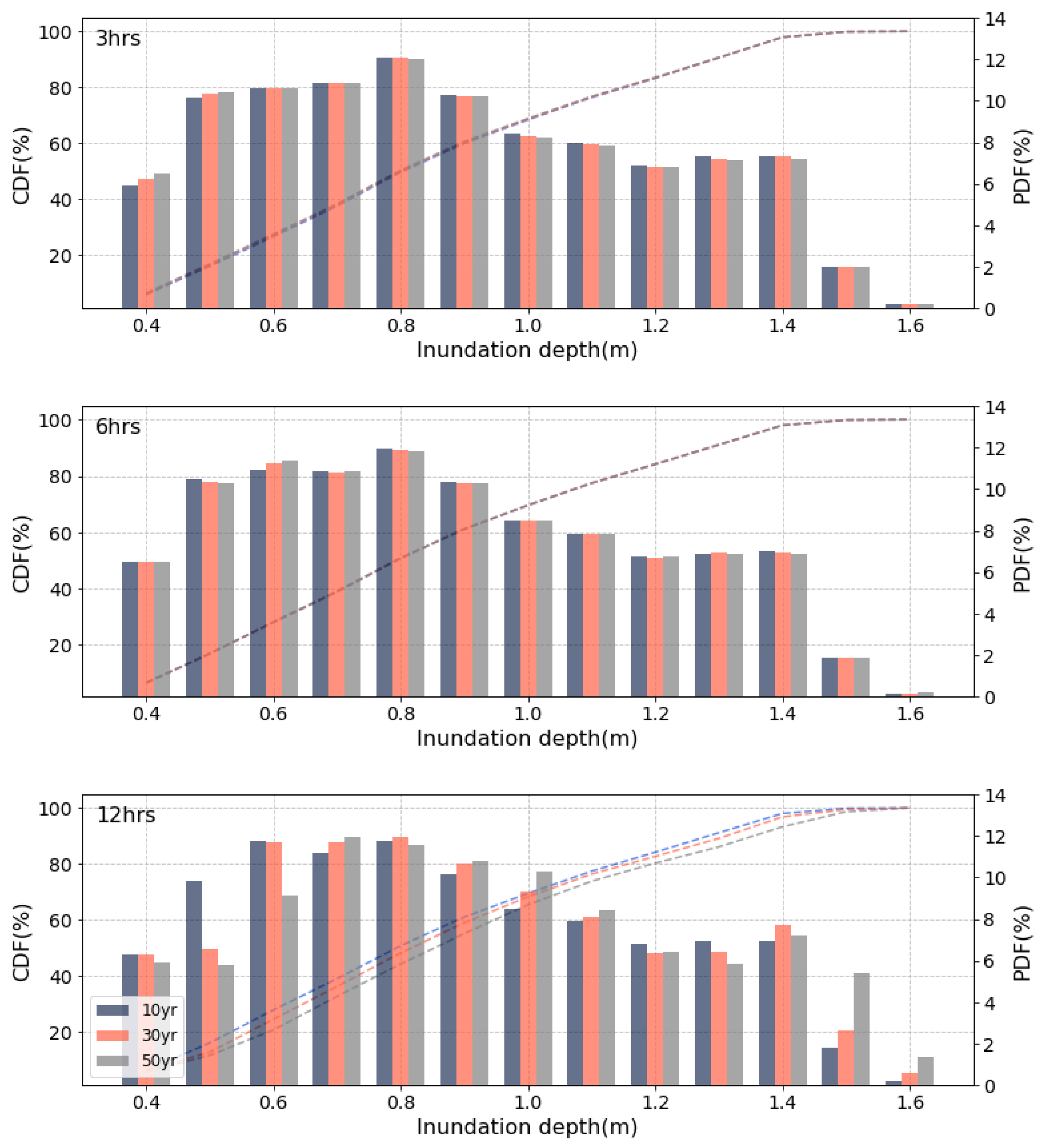
3.1. Inundation Analysis Results with Current Climate and Sea-Level Conditions
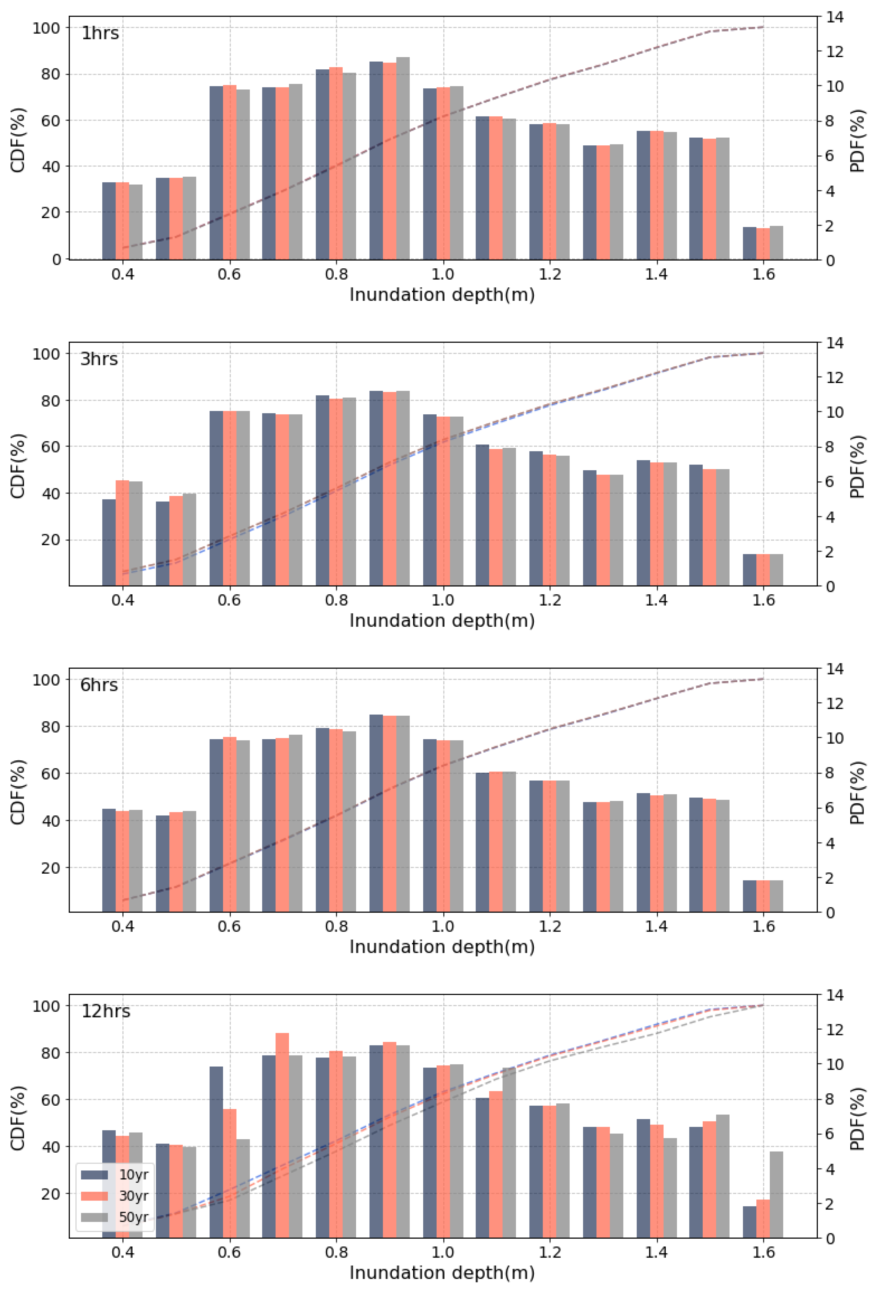
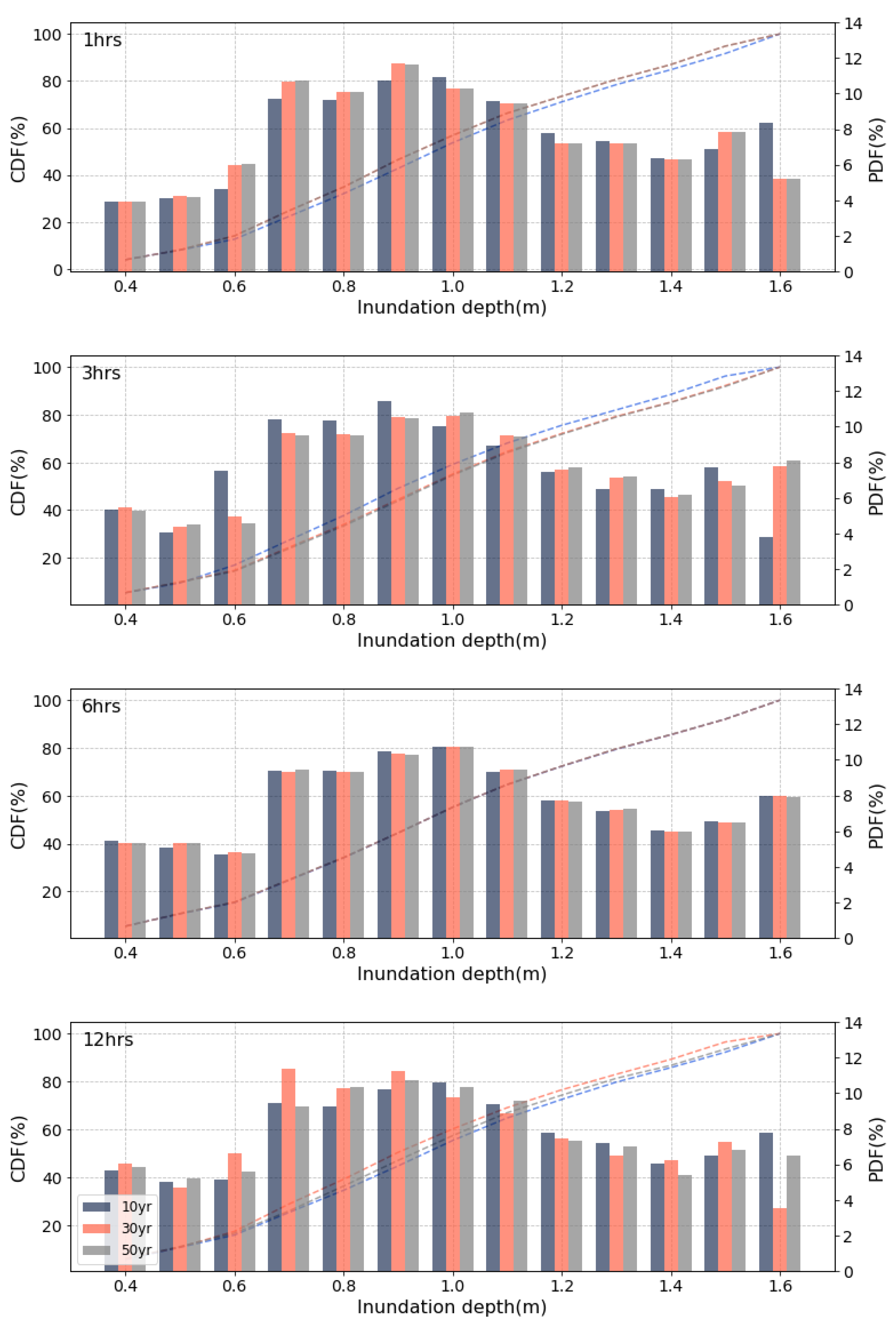
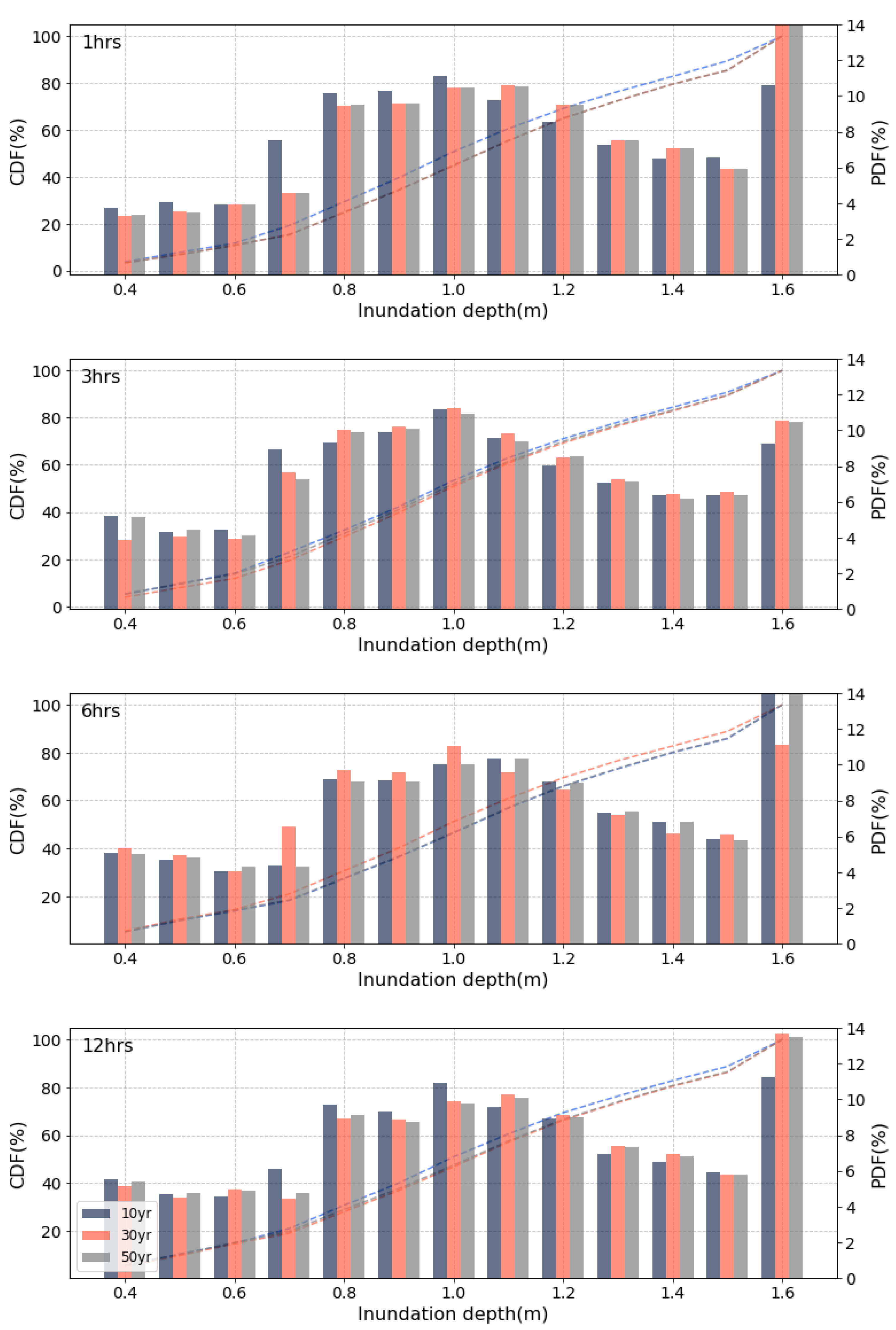
3.2. Inundation Analysis Results with Future Climate Change Scenarios
3.3. Potential Flooding Damage under Future Climate Change Scenarios
4. Discussions
5. Conclusions
Author Contributions
Funding
Institutional Review Board Statement
Informed Consent Statement
Data Availability Statement
Conflicts of Interest
References
- Wang, J.; Gao, W.; Xu, S.; Yu, L. Evaluation of the combined risk of sea level rise, land subsidence, and storm surges on the coastal areas of Shanghai, China. Clim. Chang. 2012, 115, 537–558. [Google Scholar] [CrossRef]
- Zope, P.E.; Eldho, T.I.; Jothiprakash, V. Impacts of urbanization on flooding of a coastal urban catchment: A case study of Mumbai City, India. Nat. Hazard. 2015, 75, 887–908. [Google Scholar] [CrossRef]
- Patel, P.; Ghosh, S.; Kaginalkar, A.; Islam, S.; Karmakar, S. Performance evaluation of WRF for extreme flood forecasts in a coastal urban environment. Atmos. Res. 2019, 223, 39–48. [Google Scholar] [CrossRef]
- Paulik, R.; Stephens, S.; Wild, A.; Wadhwa, S.; Bell, R.G. Cumulative building exposure to extreme sea level flooding in coastal urban areas. Int. J. Disaster Risk Reduct. 2021, 66, 102612. [Google Scholar] [CrossRef]
- Chang, H.; Franczyk, J.; Kim, C. What is responsible for increasing flood risks? The case of Gangwon Province, Korea. Nat. Hazards 2009, 48, 339–354. [Google Scholar] [CrossRef]
- Park, H.; Paterson, R.; Zigmund, S.; Shin, H.; Jang, Y.; Jung, J. The effect of coastal city development on flood damage in South Korea. Sustainability 2020, 12, 1854. [Google Scholar] [CrossRef]
- Crowell, M.; Coulton, K.; Johnson, C.; Westcott, J.; Bellomo, D.; Edelman, S.; Hirsch, E. An estimate of the US population living in 100-year coastal flood hazard areas. J. Coast. Res. 2010, 26, 201–211. [Google Scholar] [CrossRef]
- Kulp, S.; Strauss, B.H. Rapid escalation of coastal flood exposure in US municipalities from sea level rise. Clim. Chang. 2017, 142, 477–489. [Google Scholar] [CrossRef]
- Bates, P.D.; Quinn, N.; Sampson, C.; Smith, A.; Wing, O.; Sosa, J.; Savage, J.; Olcese, G.; Neal, J.; Schumann, G.; et al. Combined modeling of US fluvial, pluvial, and coastal flood hazard under current and future climates. Water Resour. Res. 2021, 57, e2020WR028673. [Google Scholar] [CrossRef]
- Chen, A.S.; Hsu, M.H.; Chen, T.S.; Chang, T.J. An integrated inundation model for highly developed urban areas. Water Sci. Technol. 2005, 51, 221–229. [Google Scholar] [CrossRef]
- Huong, H.T.L.; Pathirana, A. Urbanization and climate change impacts on future urban flooding in Can Tho city, Vietnam. Hydrol. Earth Syst. Sci. 2013, 17, 379–394. [Google Scholar] [CrossRef]
- Obaid, H.A.; Shahid, S.; Basim, K.B.K.; Shreeshivadasan, C. Modeling sewerage overflow in an urban residential area using storm water management model. Malays. J. Civ. Eng. 2014, 26, 163–171. [Google Scholar]
- Bisht, D.S.; Chatterjee, C.; Kalakoti, S.; Upadhyay, P.; Sahoo, M.; Panda, A. Modeling urban floods and drainage using SWMM and MIKE URBAN: A case study. Nat. Hazards 2016, 84, 749–776. [Google Scholar] [CrossRef]
- Fang, J.; Lincke, D.; Brown, S.; Nicholls, R.J.; Wolff, C.; Merkens, J.L.; Hinkel, J.; Vafeidis, A.T.; Shi, P.; Liu, M. Coastal flood risks in China through the 21st century–an application of DIVA. Sci. Total Environ. 2020, 704, 135311. [Google Scholar] [CrossRef]
- Vousdoukas, M.I.; Mentaschi, L.; Voukouvalas, E.; Bianchi, A.; Dottori, F.; Feyen, L. Climatic and socioeconomic controls of future coastal flood risk in Europe. Nat. Clim. Chang. 2018, 8, 776–780. [Google Scholar] [CrossRef]
- Ganguli, P.; Merz, B. Extreme coastal water levels exacerbate fluvial flood hazards in Northwestern Europe. Sci. Rep. 2019, 9, 13165. [Google Scholar] [CrossRef] [PubMed]
- Vousdoukas, M.I.; Mentaschi, L.; Hinkel, J.; Ward, P.J.; Mongelli, I.; Ciscar, J.C.; Feyen, L. Economic motivation for raising coastal flood defenses in Europe. Nat. Commun. 2020, 11, 2119. [Google Scholar] [CrossRef] [PubMed]
- Park, I.; Ha, S. An analysis on inundation characteristics of urban watershed according to variation in return period of design rainfall. J. Wetl. Res. 2013, 15, 585–593. [Google Scholar] [CrossRef]
- Park, S.J.; Lee, D.K. Prediction of coastal flooding risk under climate change impacts in South Korea using machine learning algorithms. Environ. Res. Lett. 2020, 15, 094052. [Google Scholar] [CrossRef]
- Lei, X.; Chen, W.; Panahi, M.; Falah, F.; Rahmati, O.; Uuemaa, E.; Kalantari, Z.; Ferreira, C.S.S.; Rezaied, F.; Tiefenbacher, J.P.; et al. Urban flood modeling using deep-learning approaches in Seoul, South Korea. J. Hydrol. 2021, 601, 126684. [Google Scholar] [CrossRef]
- Hsu, M.H.; Chen, S.H.; Chang, T.J. Inundation simulation for urban drainage basin with storm sewer system. J. Hydrol. 2020, 231, 21–37. [Google Scholar] [CrossRef]
- Hsu, M.H.; Chen, S.H.; Chang, T.J. Dynamic inundation simulation of storm water interaction between sewer system and overland flows. J. Chin. Inst. Eng. 2002, 25, 171–177. [Google Scholar] [CrossRef]
- Leandro, J.; Chen, A.S.; Djordjević, S.; Savić, D.A. Comparison of 1D/1D and 1D/2D coupled (sewer/surface) hydraulic models for urban flood simulation. J. Hydraul. Eng. 2009, 135, 495–504. [Google Scholar] [CrossRef]
- Kang, N.; Kim, S.; Kim, Y.; Noh, H.; Hong, S.J.; Kim, H.S. Urban drainage system improvement for climate change adaptation. Water 2016, 8, 268. [Google Scholar] [CrossRef]
- Yoon, S.S. Adaptive blending method of radar-based and numerical weather prediction QPFs for urban flood forecasting. Remote Sens. 2019, 11, 642. [Google Scholar] [CrossRef]
- Lee, M.; Yoo, Y.; Joo, H.; Kim, K.T.; Kim, H.S.; Kim, S. Construction of rating curve at high water level considering rainfall effect in a tidal river. J. Hydrol. Reg. Stud. 2021, 37, 100907. [Google Scholar] [CrossRef]
- Jeong, W.C.; Kim, K.H. A study on inundation simulation in coastal urban areas using a two-dimensional numerical model. J. Korea Water Resour. Assoc. 2011, 44, 601–617. [Google Scholar] [CrossRef][Green Version]
- Kim, D.G.; Choi, K.S.; Koh, Y.C. Inundation simulation in a urban drainage basin considering tidal stage effect. J. Korean Soc. Water Wastewater 2009, 23, 711–717. [Google Scholar]
- Moon, S.R.; Park, S.J.; Kang, J.W.; Yoon, J.T. Numerical simulations of storm surge/coastal flooding at Mokpo coastal zone by MIKE21 model. J. Korean Soc. Coast. Ocean Eng. 2006, 18, 348–359. [Google Scholar]
- Kang, N.; Noh, H.; Lee, J.; Lim, S.; Kim, H.S. Runoff simulation of an urban drainage system using radar rainfall data. J. Wetl. Res. 2013, 15, 413–422. [Google Scholar] [CrossRef]
- Schreider, S.Y.; Smith, D.I.; Jakeman, A.J. Climate change impacts on urban flooding. Clim. Chang. 2000, 47, 91–115. [Google Scholar] [CrossRef]
- Ashley, R.M.; Balmforth, D.J.; Saul, A.J.; Blanskby, J.D. Flooding in the future–predicting climate change, risks and responses in urban areas. Water Sci. Technol. 2005, 52, 265–273. [Google Scholar] [CrossRef] [PubMed]
- Purvis, M.J.; Bates, P.D.; Hayes, C.M. A probabilistic methodology to estimate future coastal flood risk due to sea level rise. Coast. Eng. 2008, 55, 1062–1073. [Google Scholar] [CrossRef]
- Zhang, Y.; Wang, Y.; Chen, Y.; Liang, F.; Liu, H. Assessment of future flash flood inundations in coastal regions under climate change scenarios—A case study of Hadahe River basin in northeastern China. Sci. Total Environ. 2019, 693, 133550. [Google Scholar] [CrossRef] [PubMed]
- Zhou, Q.; Leng, G.; Su, J.; Ren, Y. Comparison of urbanization and climate change impacts on urban flood volumes: Importance of urban planning and drainage adaptation. Sci. Total Environ. 2019, 658, 24–33. [Google Scholar] [CrossRef] [PubMed]
- Mishra, B.K.; Emam, A.R.; Masago, Y.; Kumar, P.; Regmi, R.K.; Fukushi, K. Assessment of future flood inundations under climate and land use change scenarios in the Ciliwung River Basin, Jakarta. J. Flood Risk Manag. 2018, 11, S1105–S1115. [Google Scholar] [CrossRef]
- Fuso, F.; Casale, F.; Giudici, F.; Bocchiola, D. Future hydrology of the cryospheric driven lake como catchment in Italy under climate change scenarios. Climate 2021, 9, 8. [Google Scholar] [CrossRef]
- Casale, F.; Fuso, F.; Giuliani, M.; Castelletti, A.; Bocchiola, D. Exploring future vulnerabilities of subalpine Italian regulated lakes under different climate scenarios: Bottom-up vs top-down and CMIP5 vs. CMIP6. J. Hydrol. Reg. Stud. 2021, 38, 100973. [Google Scholar] [CrossRef]
- Available online: https://www.weather.go.kr/w/index.do (accessed on 12 February 2022).
- Available online: http://www.wamis.go.kr (accessed on 12 February 2022).
- Available online: http://www.khoa.go.kr (accessed on 12 February 2022).
- Huff, F.A. Time distribution of rainfall in heavy storms. Water Resour. Res. 1967, 3, 1007–1019. [Google Scholar] [CrossRef]
- Huber, W.C.; Dickinson, R.E.; Barnwell, T.O., Jr.; Branch, A. Storm Water Management Model, Version 4; User’s Manual; US Environmental Protection Agency, Environmental Research Laboratory: Athens, GA, USA, 1988. [Google Scholar]
- Van der Sterren, M.; Rahman, A.; Ryan, G. Modeling of a lot scale rainwater tank system in XP-SWMM: A case study in Western Sydney, Australia. J. Environ. Manag. 2014, 141, 177–189. [Google Scholar] [CrossRef]
- Sterren, M.V.D.; Rahman, A.; Shrestha, S.; Thomson, A.; Lambert, M.; Daniell, T.; Leonard, M. Urban stormwater modelling in Australia: Comparison of three commercial software packages. In Proceedings of the Water Down Under 2008 Conference, Incorporating 31st Hydrology and Water Resources Symposium and 4th International Conference on Water Resources and Environment Research, Adelaide, SA, Australia, 14–17 April 2008. [Google Scholar]
- Solomon, S.; Manning, M.; Marquis, M.; Qin, D. Climate Change 2007-the Physical Science Basis: Working Group I Contribution to the Fourth Assessment Report of the IPCC (Vol. 4); Cambridge University Press: Cambridge, UK, 2007. [Google Scholar]
- Korean National Emergency Management Agency. Environmental Change Prediction of Natural Disaster and Design Criteria of the Measures for Natural Disaster Prevention and Control under Climate Change I; Korean National Emergency Management Agency: Seoul, Korea, 2011; pp. 177–190. [Google Scholar]
- Rahmstorf, S. A semi-empirical approach to projecting future sea-level rise. Science 2007, 315, 368–370. [Google Scholar] [CrossRef] [PubMed]
- Gregory, J.M.; Lowe, J.A. Predictions of global and regional sea-level rise using AOGCMs with and without flux adjustment. Geophys. Res. Lett. 2000, 27, 3069–3072. [Google Scholar] [CrossRef]
- Yin, J.; Schlesinger, M.E.; Stouffer, R.J. Model projections of rapid sea-level rise on the northeast coast of the United States. Nat. Geosci. 2009, 2, 262–266. [Google Scholar] [CrossRef]
- Duratorre, T.; Bombelli, G.M.; Menduni, G.; Bocchiola, D. Hydropower Potential in the Alps under Climate Change Scenarios. The Chavonne Plant, Val D’Aosta. Water 2020, 12, 2011. [Google Scholar] [CrossRef]
- Robertson, S. Transparency, trust, and integrated assessment models: An ethical consideration for the Intergovernmental Panel on Climate Change. Wiley Interdiscip. Rev. Clim. Chang. 2021, 12, e679. [Google Scholar] [CrossRef]
- Kadkhodazadeh, M.; Anaraki, M.V.; Morshed-Bozorgdel, A.; Farzin, S. A New Methodology for Reference Evapotranspiration Prediction and Uncertainty Analysis under Climate Change Conditions Based on Machine Learning, Multi Criteria Decision Making and Monte Carlo Methods. Sustainability 2022, 14, 2601. [Google Scholar] [CrossRef]


| Frequency (Year) | Duration (Hour) | |||
|---|---|---|---|---|
| 1 | 3 | 6 | 12 | |
| 2 | 39.6 | 73.5 | 104.6 | 139.1 |
| 3 | 42.5 | 79.0 | 111.5 | 147.8 |
| 5 | 45.7 | 85.0 | 119.2 | 157.4 |
| 10 | 49.7 | 92.7 | 128.8 | 169.6 |
| 30 | 55.8 | 104.2 | 143.4 | 188.0 |
| 50 | 58.5 | 109.5 | 150.1 | 196.4 |
| 70 | 60.4 | 112.9 | 154.4 | 201.9 |
| 80 | 61.1 | 114.3 | 156.2 | 204.0 |
| 100 | 62.3 | 116.6 | 159.0 | 207.7 |
| 200 | 66.0 | 123.7 | 168.0 | 218.9 |
| 500 | 70.9 | 133.0 | 179.8 | 233.8 |
| Duration (min) | Probable Precipitation (mm) | Duration (min) | Probable Precipitation (mm) | ||||
|---|---|---|---|---|---|---|---|
| 10 Year | 30 Year | 50 Year | 10 Year | 30 Year | 50 Year | ||
| 0 | 0.00 | 0.00 | 0.00 | 0 | 0.00 | 0.00 | 0.00 |
| 6 | 2.12 | 2.38 | 2.49 | 18 | 3.95 | 4.44 | 4.66 |
| 12 | 4.20 | 4.71 | 4.95 | 36 | 7.83 | 8.81 | 9.26 |
| 18 | 8.42 | 9.46 | 9.91 | 54 | 15.72 | 17.66 | 18.56 |
| 24 | 10.45 | 11.74 | 12.30 | 72 | 19.49 | 21.91 | 23.03 |
| 30 | 9.37 | 10.52 | 11.03 | 90 | 17.48 | 19.64 | 20.64 |
| 36 | 6.38 | 7.15 | 7.51 | 108 | 11.89 | 13.37 | 14.04 |
| 42 | 3.47 | 3.90 | 4.09 | 126 | 6.48 | 7.29 | 7.66 |
| 48 | 2.21 | 2.49 | 2.60 | 144 | 4.12 | 4.63 | 4.87 |
| 54 | 2.6 | 2.65 | 2.78 | 162 | 4.40 | 4.95 | 5.20 |
| 60 | 0.72 | 0.80 | 0.84 | 180 | 1.34 | 1.50 | 1.58 |
| 0 | 0.00 | 0.00 | 0.00 | 0 | 0.00 | 0.00 | 0.00 |
| 36 | 5.48 | 6.11 | 6.39 | 72 | 7.22 | 8.00 | 8.36 |
| 72 | 10.89 | 12.12 | 12.69 | 144 | 14.34 | 15.90 | 16.61 |
| 108 | 21.84 | 24.31 | 25.45 | 216 | 28.75 | 31.87 | 33.29 |
| 144 | 27.08 | 30.15 | 31.56 | 288 | 25.66 | 39.53 | 41.30 |
| 180 | 24.28 | 27.03 | 28.29 | 360 | 31.97 | 35.44 | 37.02 |
| 216 | 16.52 | 18.40 | 19.26 | 432 | 21.76 | 24.11 | 25.19 |
| 252 | 9.01 | 10.02 | 10.49 | 504 | 11.86 | 13.15 | 13.74 |
| 288 | 5.73 | 6.39 | 6.68 | 576 | 7.54 | 8.37 | 8.74 |
| 324 | 6.11 | 6.80 | 7.13 | 648 | 8.06 | 8.92 | 9.32 |
| 360 | 1.86 | 2.07 | 2.16 | 720 | 2.44 | 2.71 | 2.83 |
| Duration (min) | 2011–2040 (Target I) | 2041–2070 (Target II) | 2071–2100 (Target III) | ||||||
|---|---|---|---|---|---|---|---|---|---|
| Precipitation (mm) | Precipitation (mm) | Precipitation (mm) | |||||||
| 10 Year | 30 Year | 50 Year | 10 Year | 30 Year | 50 Year | 10 Year | 30 Year | 50 Year | |
| 0 | 0.00 | 0.00 | 0.00 | 0.00 | 0.00 | 0.00 | 0.00 | 0.00 | 0.00 |
| 6 | 2.39 | 2.67 | 2.79 | 2.39 | 2.67 | 2.79 | 2.57 | 2.90 | 3.05 |
| 12 | 4.74 | 5.29 | 5.55 | 4.74 | 5.29 | 5.55 | 5.09 | 5.75 | 6.05 |
| 18 | 9.51 | 10.61 | 11.11 | 9.51 | 10.61 | 11.11 | 10.22 | 11.54 | 12.14 |
| 24 | 11.80 | 13.17 | 13.79 | 11.80 | 13.17 | 13.79 | 12.68 | 14.32 | 15.06 |
| 30 | 10.5 | 11.80 | 12.37 | 10.5 | 11.80 | 12.37 | 11.36 | 12.83 | 13.50 |
| 36 | 7.20 | 8.03 | 8.41 | 7.20 | 8.03 | 8.41 | 7.74 | 8.73 | 9.18 |
| 42 | 3.92 | 4.38 | 4.58 | 3.92 | 4.38 | 4.58 | 4.21 | 4.76 | 5.01 |
| 48 | 2.50 | 2.78 | 2.92 | 2.50 | 2.78 | 2.92 | 2.69 | 3.03 | 3.18 |
| 54 | 2.66 | 2.98 | 3.11 | 2.66 | 2.98 | 3.11 | 2.86 | 3.24 | 3.40 |
| 60 | 0.81 | 0.90 | 0.95 | 0.81 | 0.90 | 0.95 | 0.87 | 0.98 | 1.03 |
| Duration (min) | 2011–2040 (Target I) | 2041–2070 (Target II) | 2071–2100 (Target III) | ||||||
|---|---|---|---|---|---|---|---|---|---|
| Precipitation (mm) | Precipitation (mm) | Precipitation (mm) | |||||||
| 10 Year | 30 Year | 50 Year | 10 Year | 30 Year | 50 Year | 10 Year | 30 Year | 50 Year | |
| 0 | 0.00 | 0.00 | 0.00 | 0.00 | 0.00 | 0.00 | 0.00 | 0.00 | 0.00 |
| 18 | 4.42 | 4.90 | 5.12 | 4.42 | 4.90 | 5.12 | 4.69 | 5.11 | 5.24 |
| 36 | 8.77 | 9.74 | 10.18 | 8.77 | 9.74 | 10.18 | 9.31 | 10.15 | 10.41 |
| 54 | 17.58 | 19.52 | 20.40 | 17.58 | 19.52 | 20.40 | 18.67 | 20.35 | 20.86 |
| 72 | 21.81 | 24.21 | 25.30 | 21.81 | 24.21 | 25.30 | 23.16 | 25.24 | 25.88 |
| 90 | 19.56 | 21.70 | 22.69 | 19.56 | 21.70 | 22.69 | 20.76 | 22.63 | 23.20 |
| 108 | 13.30 | 14.77 | 15.43 | 13.30 | 14.77 | 15.43 | 14.12 | 15.39 | 15.79 |
| 126 | 7.26 | 8.05 | 8.42 | 7.26 | 8.05 | 8.42 | 7.70 | 8.40 | 8.60 |
| 144 | 4.61 | 5.13 | 5.35 | 4.61 | 5.13 | 5.35 | 4.90 | 5.34 | 5.48 |
| 162 | 4.93 | 5.46 | 5.72 | 4.93 | 5.46 | 5.72 | 5.23 | 5.70 | 5.85 |
| 180 | 1.49 | 1.66 | 1.73 | 1.49 | 1.66 | 1.73 | 1.59 | 1.73 | 1.77 |
| Duration (min) | 2011–2040 (Target I) | 2041–2070 (Target II) | 2071–2100 (Target III) | ||||||
|---|---|---|---|---|---|---|---|---|---|
| Precipitation (mm) | Precipitation (mm) | Precipitation (mm) | |||||||
| 10 Year | 30 Year | 50 Year | 10 Year | 30 Year | 50 Year | 10 Year | 30 Year | 50 Year | |
| 0 | 0.00 | 0.00 | 0.00 | 0.00 | 0.00 | 0.00 | 0.00 | 0.00 | 0.00 |
| 36 | 6.11 | 6.77 | 7.07 | 6.19 | 6.77 | 7.07 | 6.39 | 6.91 | 7.15 |
| 72 | 12.13 | 13.45 | 14.05 | 12.28 | 13.45 | 14.05 | 12.69 | 13.73 | 14.20 |
| 108 | 24.32 | 26.95 | 28.17 | 24.63 | 26.95 | 28.17 | 25.43 | 27.51 | 29.47 |
| 144 | 30.17 | 33.45 | 34.94 | 30.55 | 33.45 | 34.94 | 31.55 | 34.14 | 35.32 |
| 180 | 27.05 | 29.97 | 31.32 | 27.39 | 29.97 | 31.32 | 28.29 | 30.60 | 31.67 |
| 216 | 18.40 | 20.40 | 21.31 | 18.63 | 20.40 | 21.31 | 19.25 | 20.82 | 21.54 |
| 252 | 10.04 | 11.12 | 11.62 | 10.16 | 11.12 | 11.62 | 10.49 | 11.35 | 11.74 |
| 288 | 6.38 | 7.08 | 7.40 | 6.47 | 7.08 | 7.40 | 6.68 | 7.22 | 7.48 |
| 324 | 6.84 | 7.55 | 7.89 | 6.89 | 7.55 | 7.89 | 7.12 | 7.71 | 7.97 |
| 360 | 2.06 | 2.29 | 2.39 | 2.10 | 2.29 | 2.39 | 2.16 | 2.34 | 2.42 |
| Duration (min) | 2011–2040 (Target I) | 2041–2070 (Target II) | 2071–2100 (Target III) | ||||||
|---|---|---|---|---|---|---|---|---|---|
| Precipitation (mm) | Precipitation (mm) | Precipitation (mm) | |||||||
| 10 Year | 30 Year | 50 Year | 10 Year | 30 Year | 50 Year | 10 Year | 30 Year | 50 Year | |
| 0 | 0.00 | 0.00 | 0.00 | 0.00 | 0.00 | 0.00 | 0.00 | 0.00 | 0.00 |
| 72 | 7.77 | 8.50 | 8.84 | 7.78 | 8.51 | 8.84 | 7.85 | 8.55 | 8.84 |
| 144 | 15.43 | 16.88 | 17.55 | 15.46 | 16.90 | 17.55 | 15.59 | 16.97 | 17.55 |
| 216 | 30.93 | 33.85 | 35.19 | 30.99 | 33.87 | 35.19 | 31.25 | 34.04 | 35.19 |
| 288 | 38.38 | 41.98 | 43.65 | 38.45 | 42.02 | 43.65 | 38.76 | 42.22 | 43.65 |
| 360 | 34.40 | 37.64 | 39.14 | 34.46 | 37.68 | 39.14 | 34.76 | 37.85 | 39.14 |
| 432 | 23.40 | 25.60 | 26.62 | 23.45 | 25.63 | 26.62 | 23.64 | 25.75 | 26.62 |
| 504 | 12.77 | 13.97 | 14.52 | 12.79 | 13.97 | 14.52 | 12.89 | 14.04 | 14.52 |
| 576 | 8.12 | 8.88 | 9.24 | 8.13 | 8.90 | 9.24 | 8.21 | 8.94 | 9.24 |
| 648 | 8.66 | 9.48 | 9.85 | 8.69 | 9.49 | 9.85 | 8.75 | 9.53 | 9.85 |
| 720 | 2.63 | 2.88 | 2.99 | 2.63 | 2.87 | 2.99 | 2.66 | 2.89 | 2.99 |
| 2011–2040 (Target I) | 2041–2070 (Target II) | 2071–2100 (Target III) | |
|---|---|---|---|
| East sea | 8 cm | 18 cm | 28 cm |
| South sea | 10 cm | 20 cm | 30 cm |
| West sea | 12 cm | 24 cm | 32 cm |
Publisher’s Note: MDPI stays neutral with regard to jurisdictional claims in published maps and institutional affiliations. |
© 2022 by the authors. Licensee MDPI, Basel, Switzerland. This article is an open access article distributed under the terms and conditions of the Creative Commons Attribution (CC BY) license (https://creativecommons.org/licenses/by/4.0/).
Share and Cite
Han, H.; Kim, D.; Kim, H.S. Inundation Analysis of Coastal Urban Area under Climate Change Scenarios. Water 2022, 14, 1159. https://doi.org/10.3390/w14071159
Han H, Kim D, Kim HS. Inundation Analysis of Coastal Urban Area under Climate Change Scenarios. Water. 2022; 14(7):1159. https://doi.org/10.3390/w14071159
Chicago/Turabian StyleHan, Heechan, Deokhwan Kim, and Hung Soo Kim. 2022. "Inundation Analysis of Coastal Urban Area under Climate Change Scenarios" Water 14, no. 7: 1159. https://doi.org/10.3390/w14071159
APA StyleHan, H., Kim, D., & Kim, H. S. (2022). Inundation Analysis of Coastal Urban Area under Climate Change Scenarios. Water, 14(7), 1159. https://doi.org/10.3390/w14071159