Assessment of Riverbank Erosion Hotspots along the Mekong River in Cambodia Using Remote Sensing and Hazard Exposure Mapping
Abstract
:1. Introduction
2. Study Area
2.1. Mekong River
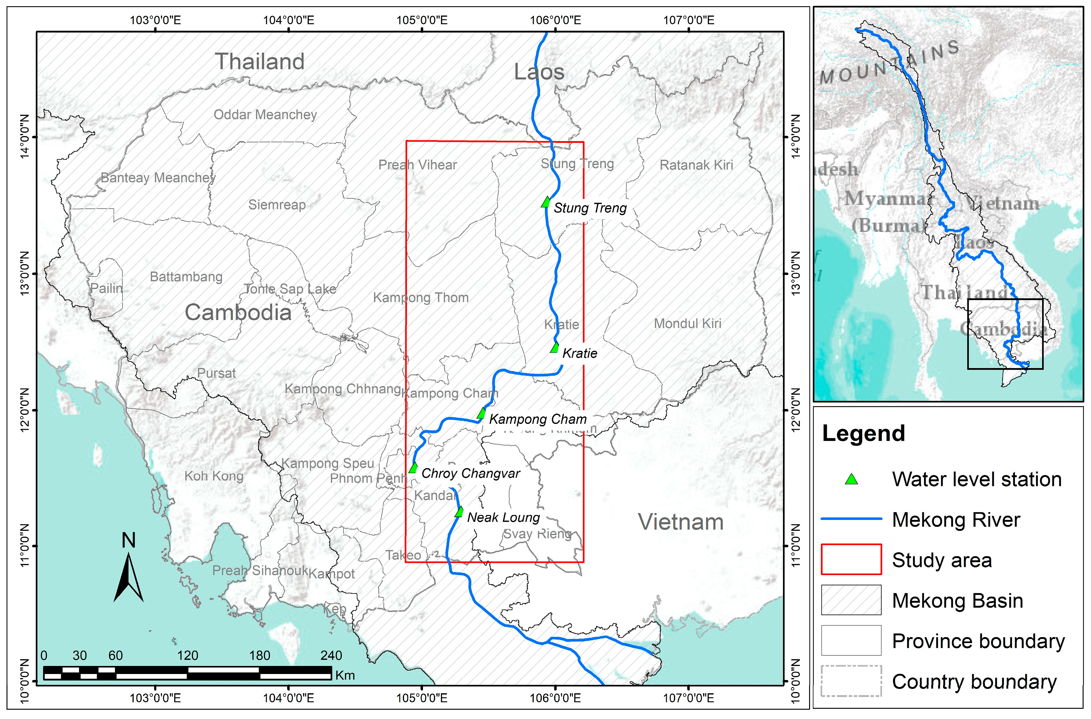
2.2. Mekong River in Cambodia
3. Methodology
3.1. Riverbank Erosion and Deposition Mapping
3.2. Riverbank Line Identification Using Water Indices
3.2.1. Water Indices
3.2.2. Water Threshold
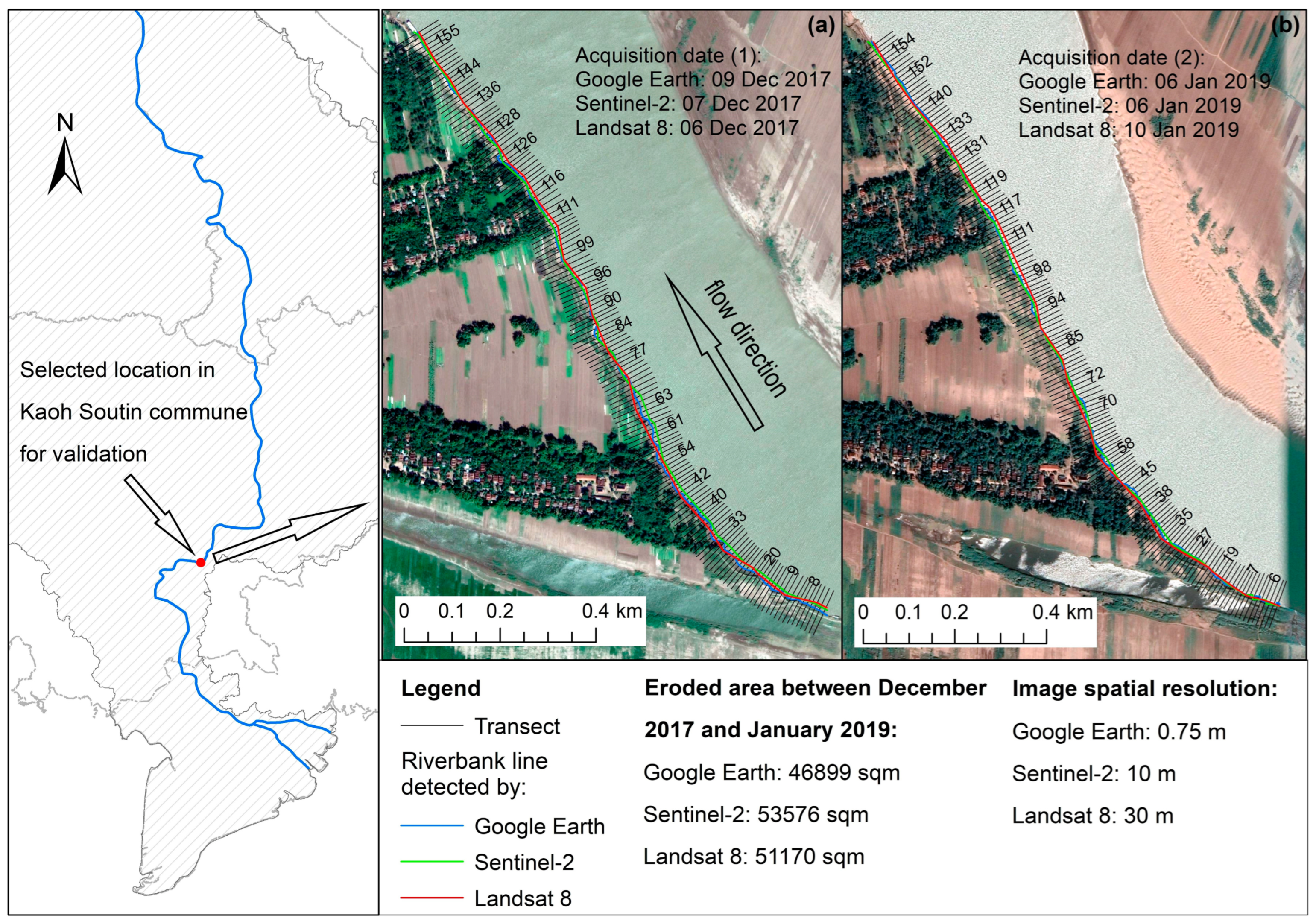
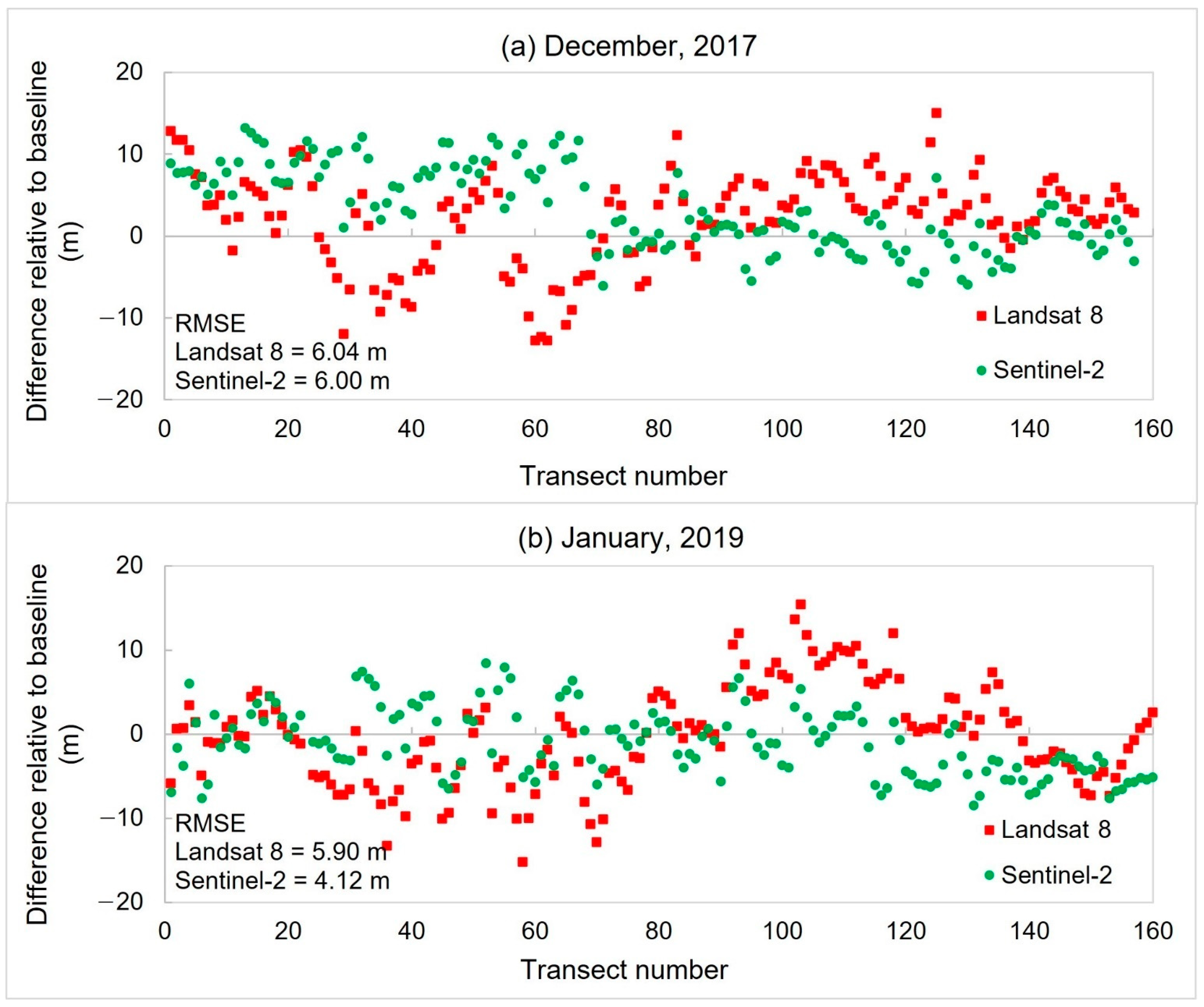
3.2.3. Validation of Landsat and Sentinel-2 Images with Google Earth Images
3.3. Riverbank Change Rate
3.4. Exposure and Hotspot Mapping
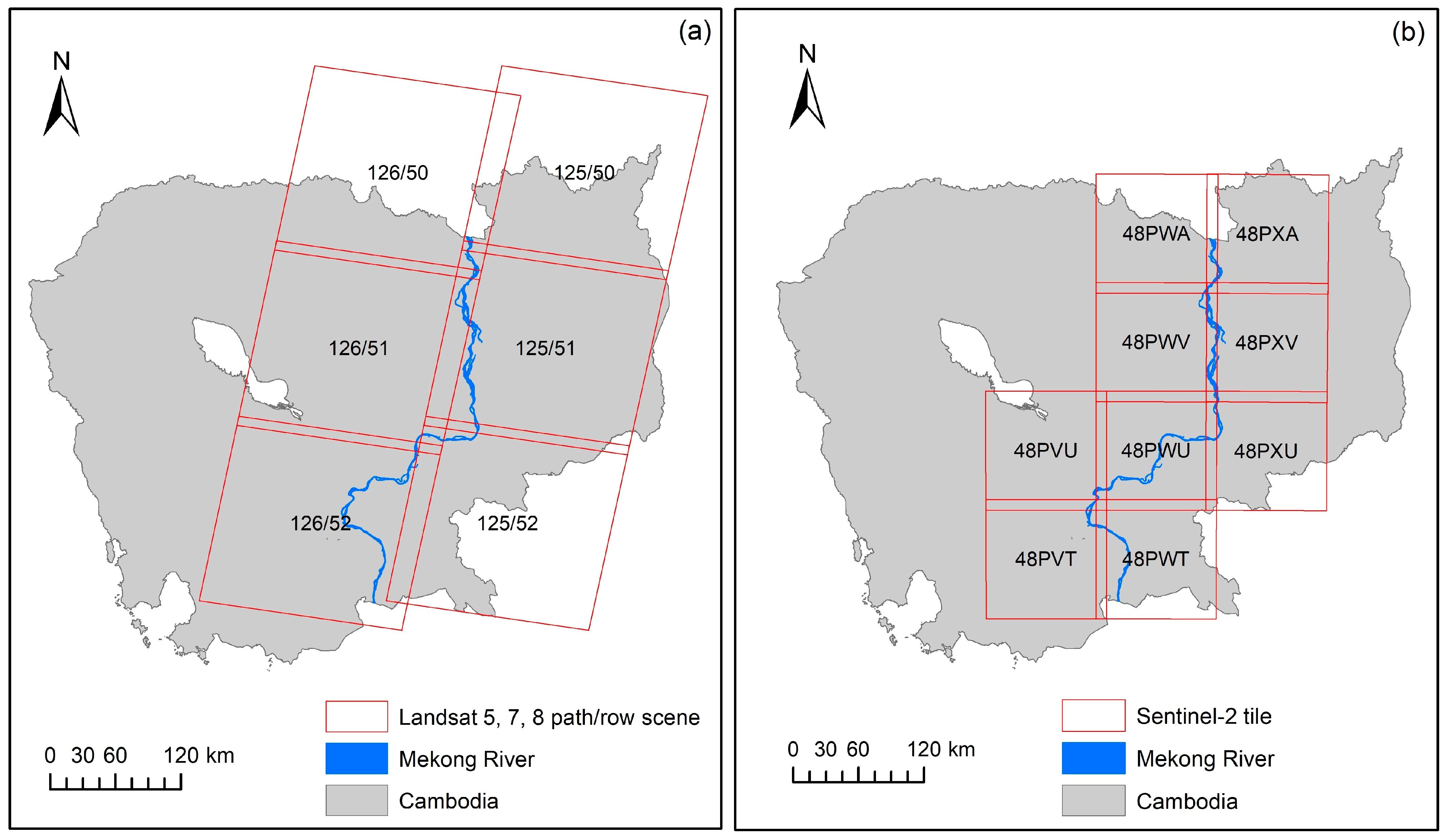
3.5. Data
3.5.1. Landsat
3.5.2. Sentinel-2
3.5.3. Land Cover
3.5.4. Population Density
4. Results and Discussion
4.1. Comparison of Riverbank Erosion Detected by Landsat 8 and Sentinel-2
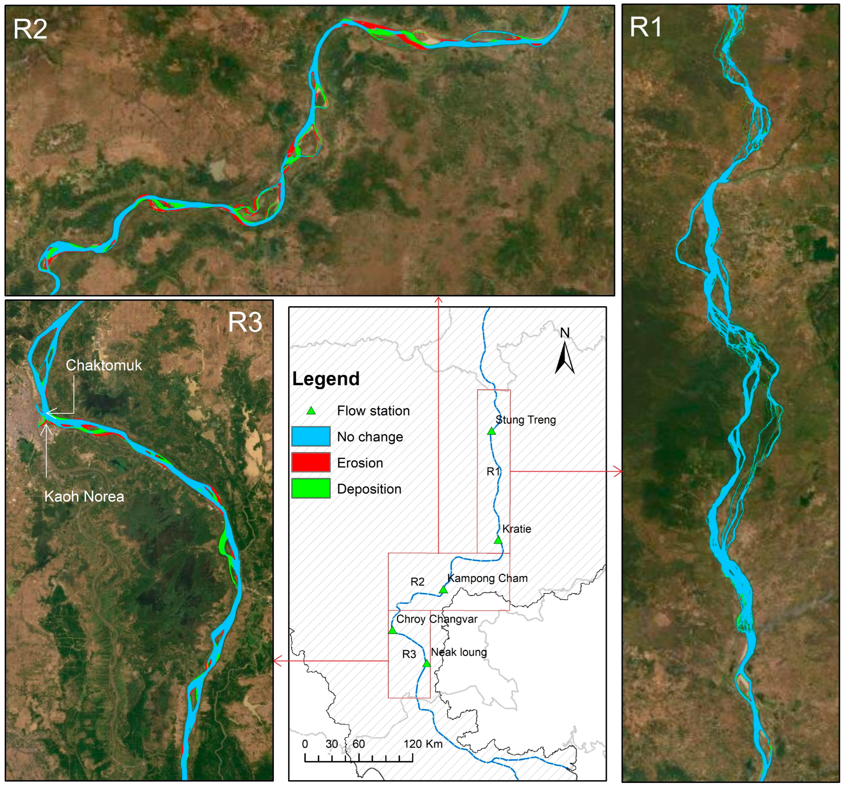
4.2. Riverbank Erosion and Deposition
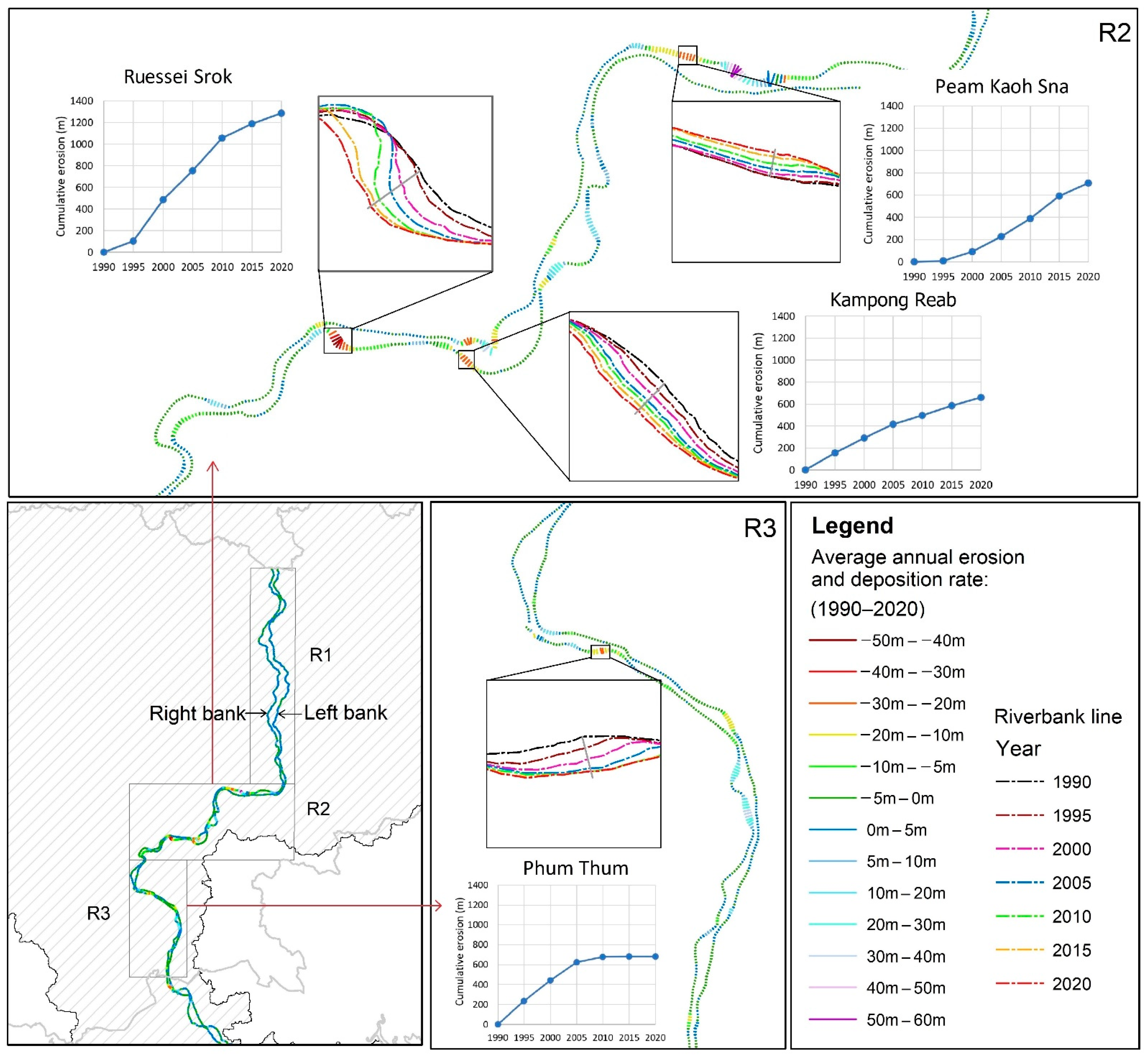
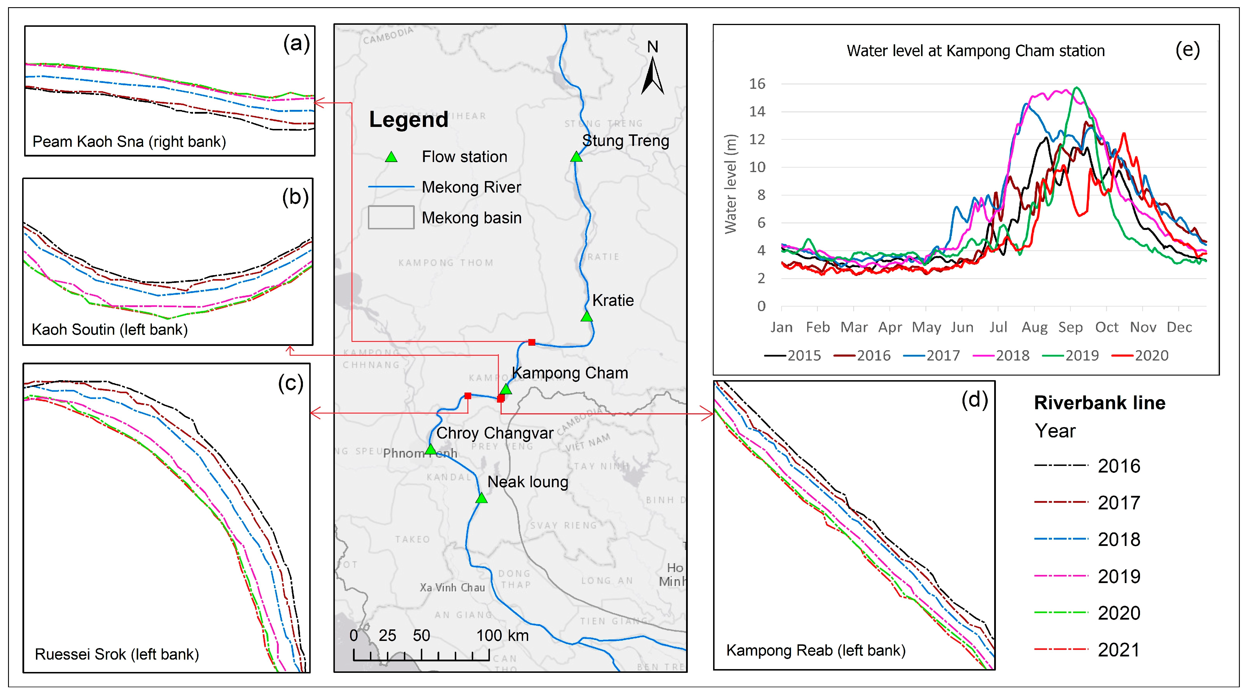
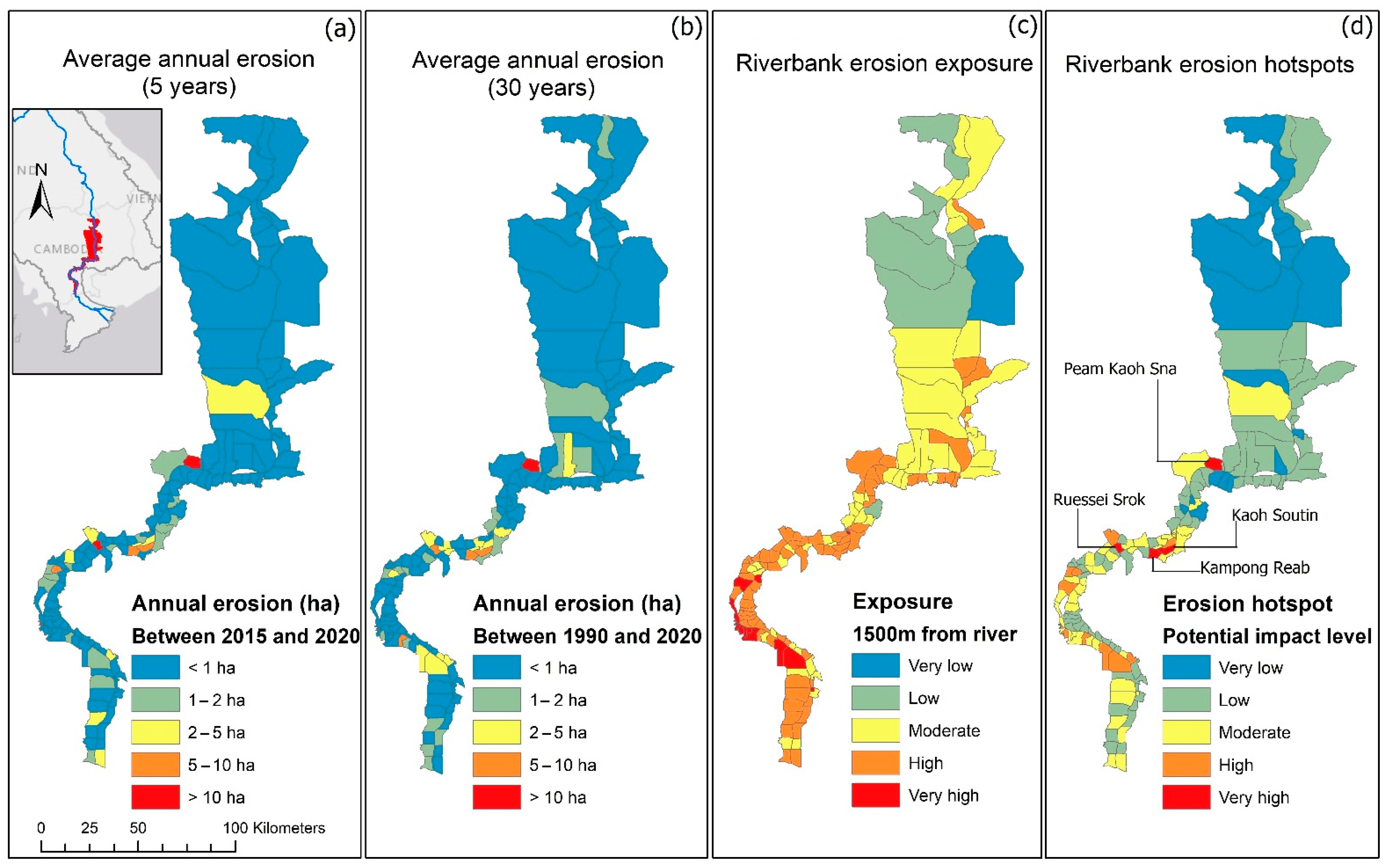
4.3. Riverbank Erosion Rate
4.3.1. Long-Term Erosion
4.3.2. Short-Term Erosion
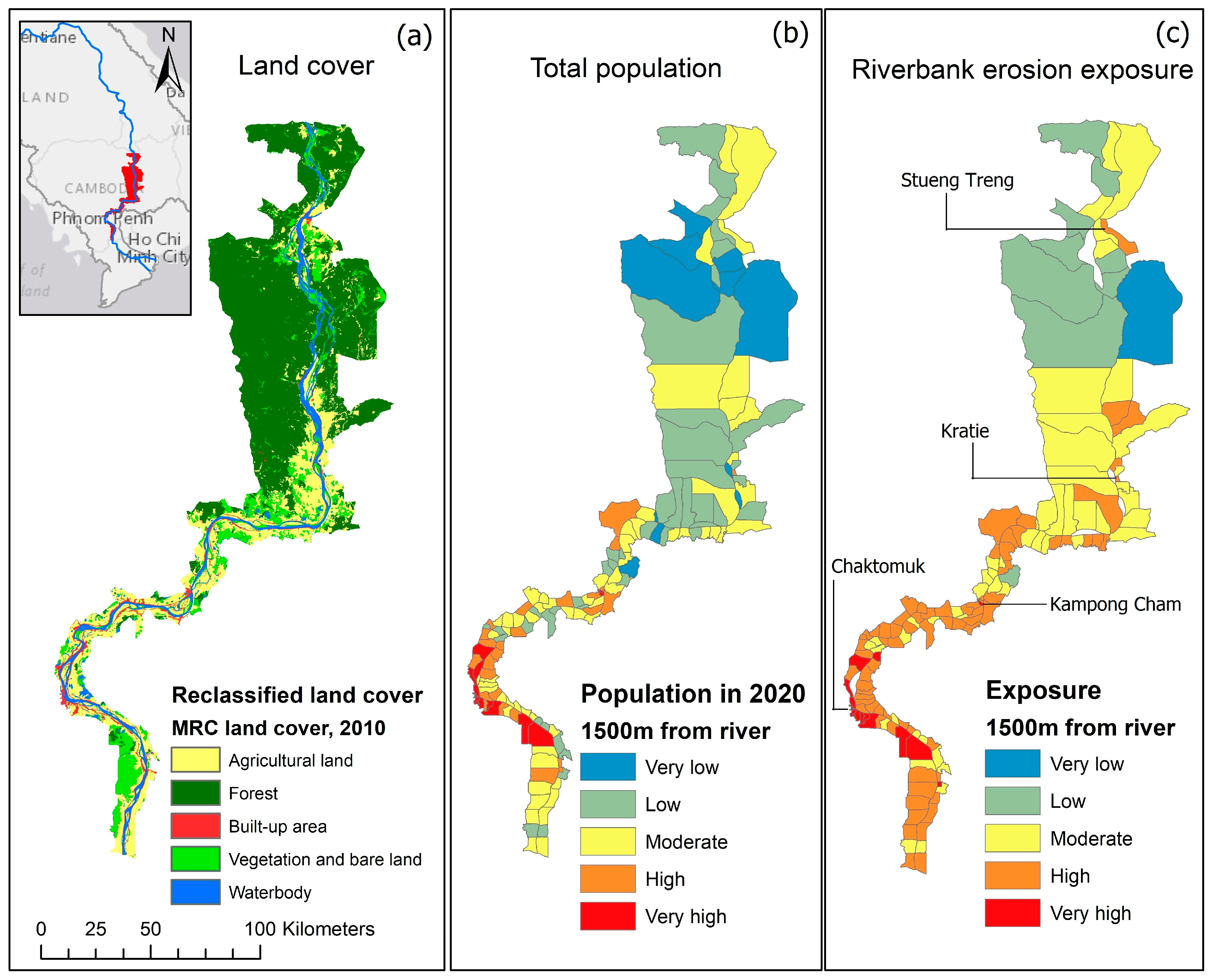
4.4. Riverbank Erosion Hotspots
4.4.1. Riverbank Erosion Exposure
4.4.2. Erosion Hotspots
5. Conclusions
Author Contributions
Funding
Institutional Review Board Statement
Informed Consent Statement
Data Availability Statement
Acknowledgments
Conflicts of Interest
References
- Kummu, M.; Lu, X.; Rasphone, A.; Sarkkula, J.; Koponen, J. Riverbank changes along the Mekong River: Remote sensing detection in the Vientiane–Nong Khai area. Quat. Int. 2008, 186, 100–112. [Google Scholar] [CrossRef] [Green Version]
- Naher, J.; Soron, T.R. Impact of River Bank Erosion on Mental Health and Coping Capacity in Bangladesh. Glob. Psychiatry 2019, 2, 195–200. [Google Scholar] [CrossRef] [Green Version]
- Rahman, M.S.; Gain, A. Adaptation to river bank erosion induced displacement in Koyra Upazila of Bangladesh. Prog. Disaster Sci. 2020, 5, 100055. [Google Scholar] [CrossRef]
- Daily Sun. River Erosion Turns Terrible in Naria. Available online: https://www.daily-sun.com/arcprint/details/336162/River-erosion-turns-terrible-in-Naria-/2018-09-15 (accessed on 29 December 2020).
- Das, T.K.; Haldar, S.K.; Gupta, I.D.; Sen, S. River bank erosion induced human displacement and its consequences. Living Rev. Landsc. Res. 2014, 8, 1–35. [Google Scholar] [CrossRef] [Green Version]
- Hartwig, M.; Schäffer, M.; Theuring, P.; Avlyush, S.; Rode, M.; Borchardt, D. Cause–effect–response chains linking source identification of eroded sediments, loss of aquatic ecosystem integrity and management options in a steppe river catchment (Kharaa, Mongolia). Environ. Earth Sci. 2016, 75, 855. [Google Scholar] [CrossRef]
- MRC. Basin Development Strategy 2016–2020 for the Lower Mekong Basin; Mekong River Commission: Phnom Penh, Cambodia, 2016. [Google Scholar]
- Miyazawa, N.; Sunada, K.; Sokhem, P. Bank erosion in the Mekong River Basin: Is Bank Erosion In My Town Caused by the activities of my neighbours? In A Critical Review of Water and Development Concepts, Principles and Policies; Water & Development Publications, Helsinki University of Technology: Helsinki, Finland, 2008; pp. 19–26. [Google Scholar]
- MRC. State of the Basin Report 2010; Mekong River Commission for Sustainable Development: Vientiane, Laos, 2010. [Google Scholar]
- MRC. State of the Basin Report 2018; Mekong River Commission for Sustainable Development: Vientiane, Laos, 2019. [Google Scholar]
- MRC. The Council Study: Study on the sustainable Management and Development of the Mekong River, Including Impacts of Mainstream Hydropower Projects. In Volume 4: Assessment of Planned Development Scenarios; BioRA Final Technical Report Series; Mekong River Commission for Sustainable Development: Vientiane, Laos, 2017; 145p. [Google Scholar]
- Hackney, C.R.; Darby, S.E.; Parsons, D.R.; Leyland, J.; Best, J.L.; Aalto, R.; Nicholas, A.P.; Houseago, R.C. River bank instability from unsustainable sand mining in the lower Mekong River. Nat. Sustain. 2020, 3, 217–225. [Google Scholar] [CrossRef]
- Jordan, C.; Tiede, J.; Lojek, O.; Visscher, J.; Apel, H.; Nguyen, H.Q.; Quang, C.N.X.; Schlurmann, T. Sand mining in the Mekong Delta revisited-current scales of local sediment deficits. Sci. Rep. 2019, 9, 17823. [Google Scholar] [CrossRef]
- Khmer Times. Riverbank Collapses Affect Nearly 40 Homes in Two Provinces. Available online: https://www.khmertimeskh.com/650536/riverbank-collapses-affect-nearly-40-homes-in-two-provinces/?fbclid=IwAR1ZhGVWTwlmFq40vkk8nrdahM7KsWaIWenu9_6EgEbPg6I0l1p29lsyIcs (accessed on 3 December 2020).
- RFA. Three Cambodians Missing After Mekong Bank Collapse. Available online: https://www.rfa.org/english/news/myanmar/cambodia/collapse-02192014171310.html (accessed on 3 December 2020).
- Palmer, J.A.; Schilling, K.E.; Isenhart, T.M.; Schultz, R.C.; Tomer, M.D. Streambank erosion rates and loads within a single watershed: Bridging the gap between temporal and spatial scales. Geomorphology 2014, 209, 66–78. [Google Scholar] [CrossRef] [Green Version]
- Chapuis, M.; Dufour, S.; Provansal, M.; Couvert, B.; de Linares, M. Coupling channel evolution monitoring and RFID tracking in a large, wandering, gravel-bed river: Insights into sediment routing on geomorphic continuity through a riffle–pool sequence. Geomorphology 2015, 231, 258–269. [Google Scholar] [CrossRef]
- Khoi, D.N.; Dang, T.D.; Pham, L.T.; Loi, P.T.; Thuy, N.T.D.; Phung, N.K.; Bay, N.T. Morphological change assessment from intertidal to river-dominated zones using multiple-satellite imagery: A case study of the Vietnamese Mekong Delta. Reg. Stud. Mar. Sci. 2020, 34, 101087. [Google Scholar] [CrossRef]
- Lam-Dao, N.; Pham-Bach, V.; Nguyen-Thanh, M.; Pham-Thi, M.-T.; Hoang-Phi, P. Change detection of land use and riverbank in Mekong Delta, Vietnam using time series remotely sensed data. J. Resour. Ecol. 2011, 2, 370–374. [Google Scholar]
- Longoni, L.; Papini, M.; Brambilla, D.; Barazzetti, L.; Roncoroni, F.; Scaioni, M.; Ivanov, V.I. Monitoring riverbank erosion in mountain catchments using terrestrial laser scanning. Remote Sens. 2016, 8, 241. [Google Scholar] [CrossRef] [Green Version]
- Langat, P.K.; Kumar, L.; Koech, R. Monitoring river channel dynamics using remote sensing and GIS techniques. Geomorphology 2019, 325, 92–102. [Google Scholar] [CrossRef]
- Thakur, P.K.; Laha, C.; Aggarwal, S. River bank erosion hazard study of river Ganga, upstream of Farakka barrage using remote sensing and GIS. Nat. Hazards 2012, 61, 967–987. [Google Scholar] [CrossRef]
- Hemmelder, S.; Marra, W.; Markies, H.; De Jong, S.M. Monitoring river morphology & bank erosion using UAV imagery–A case study of the river Buëch, Hautes-Alpes, France. Int. J. Appl. Earth Obs. Geoinf. 2018, 73, 428–437. [Google Scholar] [CrossRef]
- Hamshaw, S.D.; Bryce, T.; O’Neil Dunne, J.; Rizzo, D.M.; Frolik, J.; Engel, T.; Dewoolkar, M.M. Quantifying streambank erosion using unmanned aerial systems at site-specific and river network scales. In Geotechnical Frontiers 2017; ASCE: Anaheim, CA, USA, 2017; pp. 499–508. [Google Scholar]
- Dragićević, S.; Pripužić, M.; Živković, N.; Novković, I.; Kostadinov, S.; Langović, M.; Milojković, B.; Čvorović, Z. Spatial and temporal variability of bank erosion during the period 1930–2016: Case Study—Kolubara River Basin (Serbia). Water 2017, 9, 748. [Google Scholar] [CrossRef] [Green Version]
- Miřijovský, J.; Langhammer, J. Multitemporal monitoring of the morphodynamics of a mid-mountain stream using UAS photogrammetry. Remote Sens. 2015, 7, 8586–8609. [Google Scholar] [CrossRef] [Green Version]
- Boonpook, W.; Tan, Y.; Ye, Y.; Torteeka, P.; Torsri, K.; Dong, S. A deep learning approach on building detection from unmanned aerial vehicle-based images in riverbank monitoring. Sensors 2018, 18, 3921. [Google Scholar] [CrossRef] [Green Version]
- Thoma, D.P.; Gupta, S.C.; Bauer, M.E.; Kirchoff, C. Airborne laser scanning for riverbank erosion assessment. Remote Sens. Environ. 2005, 95, 493–501. [Google Scholar] [CrossRef]
- Billah, M.M. Mapping and monitoring erosion-accretion in an alluvial river using satellite imagery–the river bank changes of the Padma river in Bangladesh. Quaest. Geogr. 2018, 37, 87–95. [Google Scholar] [CrossRef] [Green Version]
- Binh, D.V.; Wietlisbach, B.; Kantoush, S.; Loc, H.H.; Park, E.; Cesare, G.d.; Cuong, D.H.; Tung, N.X.; Sumi, T. A Novel Method for River Bank Detection from Landsat Satellite Data: A Case Study in the Vietnamese Mekong Delta. Remote Sens. 2020, 12, 3298. [Google Scholar] [CrossRef]
- Yao, Z.; Ta, W.; Jia, X.; Xiao, J. Bank erosion and accretion along the Ningxia–Inner Mongolia reaches of the Yellow River from 1958 to 2008. Geomorphology 2011, 127, 99–106. [Google Scholar] [CrossRef]
- Tu, N.A.; Stéphane, G.; Le, P.T.; Xuan, N.H.; Doi, N.T. Rapid detection of changes in the riverbanks of Laigiang river of the South Central Coast Vietnam: A methodology based on Digital Shoreline Analysis System and Sentinel-2. Disaster Adv. 2021, 14, 13–24. [Google Scholar] [CrossRef]
- Mondejar, J.P.; Tongco, A.F. Near infrared band of Landsat 8 as water index: A case study around Cordova and Lapu-Lapu City, Cebu, Philippines. Sustain. Environ. Res. 2019, 29, 16. [Google Scholar] [CrossRef] [Green Version]
- Work, E.A.; Gilmer, D.S. Utilization of satellite data for inventorying prairie ponds and lakes. Photogramm. Eng. Remote Sens. 1976, 42, 685–694. [Google Scholar]
- McFeeters, S.K. The use of the Normalized Difference Water Index (NDWI) in the delineation of open water features. Int. J. Remote Sens. 1996, 17, 1425–1432. [Google Scholar] [CrossRef]
- Xu, H. Modification of normalised difference water index (NDWI) to enhance open water features in remotely sensed imagery. Int. J. Remote Sens. 2006, 27, 3025–3033. [Google Scholar] [CrossRef]
- Dang, B.; Li, Y. MSResNet: Multiscale Residual Network via Self-Supervised Learning for Water-Body Detection in Remote Sensing Imagery. Remote Sens. 2021, 13, 3122. [Google Scholar] [CrossRef]
- Chen, Y.; Fan, R.; Yang, X.; Wang, J.; Latif, A. Extraction of urban water bodies from high-resolution remote-sensing imagery using deep learning. Water 2018, 10, 585. [Google Scholar] [CrossRef] [Green Version]
- Kaplan, G.; Avdan, U. Object-based water body extraction model using Sentinel-2 satellite imagery. Eur. J. Remote Sens. 2017, 50, 137–143. [Google Scholar] [CrossRef] [Green Version]
- Huang, X.; Xie, C.; Fang, X.; Zhang, L. Combining pixel-and object-based machine learning for identification of water-body types from urban high-resolution remote-sensing imagery. IEEE J. Sel. Top. Appl. Earth Obs. Remote Sens. 2015, 8, 2097–2110. [Google Scholar] [CrossRef]
- Wang, L.; Bie, W.; Li, H.; Liao, T.; Ding, X.; Wu, G.; Fei, T. Small Water Body Detection and Water Quality Variations with Changing Human Activity Intensity in Wuhan. Remote Sens. 2022, 14, 200. [Google Scholar] [CrossRef]
- Li, L.; Yan, Z.; Shen, Q.; Cheng, G.; Gao, L.; Zhang, B. Water body extraction from very high spatial resolution remote sensing data based on fully convolutional networks. Remote Sens. 2019, 11, 1162. [Google Scholar] [CrossRef] [Green Version]
- Wang, G.; Wu, M.; Wei, X.; Song, H. Water identification from high-resolution remote sensing images based on multidimensional densely connected convolutional neural networks. Remote Sens. 2020, 12, 795. [Google Scholar] [CrossRef] [Green Version]
- Li, M.; Wu, P.; Wang, B.; Park, H.; Yang, H.; Wu, Y. A deep learning method of water body extraction from high resolution remote sensing images with multisensors. IEEE J. Sel. Top. Appl. Earth Obs. Remote Sens. 2021, 14, 3120–3132. [Google Scholar] [CrossRef]
- Zhang, L.; Fan, Y.; Yan, R.; Shao, Y.; Wang, G.; Wu, J. Fine-Grained Tidal Flat Waterbody Extraction Method (FYOLOv3) for High-Resolution Remote Sensing Images. Remote Sens. 2021, 13, 2594. [Google Scholar] [CrossRef]
- Isikdogan, L.F.; Bovik, A.; Passalacqua, P. Seeing through the clouds with deepwatermap. IEEE Geosci. Remote Sens. Lett. 2019, 17, 1662–1666. [Google Scholar] [CrossRef]
- Feng, W.; Sui, H.; Huang, W.; Xu, C.; An, K. Water body extraction from very high-resolution remote sensing imagery using deep U-Net and a superpixel-based conditional random field model. IEEE Geosci. Remote Sens. Lett. 2018, 16, 618–622. [Google Scholar] [CrossRef]
- Jiang, W.; He, G.; Long, T.; Ni, Y. Detecting water bodies in landsat8 oli image using deep learning. Int. Arch. Photogramm. Remote Sens. Spat. Inf. Sci. 2018, 42, 3. [Google Scholar] [CrossRef] [Green Version]
- Yang, L.; Driscol, J.; Sarigai, S.; Wu, Q.; Lippitt, C.D.; Morgan, M. Towards Synoptic Water Monitoring Systems: A Review of AI Methods for Automating Water Body Detection and Water Quality Monitoring Using Remote Sensing. Sensors 2022, 22, 2416. [Google Scholar] [CrossRef]
- Li, A.; Fan, M.; Qin, G.; Xu, Y.; Wang, H. Comparative Analysis of Machine Learning Algorithms in Automatic Identification and Extraction of Water Boundaries. Appl. Sci. 2021, 11, 10062. [Google Scholar] [CrossRef]
- Lu, X.; Kummu, M.; Oeurng, C. Reappraisal of sediment dynamics in the Lower Mekong River, Cambodia. Earth Surf. Process. Landf. 2014, 39, 1855–1865. [Google Scholar] [CrossRef]
- Lauri, H.; De Moel, H.; Ward, P.; Räsänen, T.; Keskinen, M.; Kummu, M. Future changes in Mekong River hydrology: Impact of climate change and reservoir operation on discharge. Hydrol. Earth Syst. Sci. Discuss 2012, 9, 6569–6614. [Google Scholar] [CrossRef]
- Gupta, A. The Mekong River: Morphology, evolution, management. In Large Rivers: Geomorphology and Management, 2nd ed.; Gupta, A., Ed.; John Wiley & Sons Ltd.: Chichester, UK, 2007; pp. 435–455. [Google Scholar]
- Gupta, A.; Liew, S.C. The Mekong from satellite imagery: A quick look at a large river. Geomorphology 2007, 85, 259–274. [Google Scholar] [CrossRef]
- Carling, P.A. The geology of the lower Mekong River. In The Mekong; Elsevier: Amsterdam, The Netherlands, 2009; pp. 13–28. [Google Scholar]
- Meshkova, L.V.; Carling, P.A. The geomorphological characteristics of the Mekong River in northern Cambodia: A mixed bedrock–alluvial multi-channel network. Geomorphology 2012, 147, 2–17. [Google Scholar] [CrossRef]
- Chan, S.; Putrea, S.; Sean, K.; Hortle, K. Using local knowledge to inventory deep pools, important fish habitats in Cambodia. In Proceedings of the 6th Technical Symposium on Mekong Fisheries, Pakse, Laos, 26–28 November 2003. [Google Scholar]
- MRC. Mekong River Commission for Sustainable Development. Available online: http://ffw.mrcmekong.org/aboutus.php (accessed on 10 May 2022).
- Thoeun, H.C. Observed and projected changes in temperature and rainfall in Cambodia. Weather Clim. Extrem. 2015, 7, 61–71. [Google Scholar] [CrossRef] [Green Version]
- MRC. The Flow of the Mekong; Mekong River Commission for Sustainable Development: Vientiane, Laos, 2009. [Google Scholar]
- MRC. MRC Data and Information Service. Available online: https://portal.mrcmekong.org (accessed on 6 April 2022).
- Koehnken, L. Discharge Sediment Monitoring Project (DSMP), 2009–2013: Summary & Analysis of Results; Final Report Mekong River Commission; Mekong River Commission for Sustainable Development: Vientiane, Laos, 2014. [Google Scholar]
- Himmelstoss, E.A.; Henderson, R.E.; Kratzmann, M.G.; Farris, A.S. Digital Shoreline Analysis System (DSAS) Version 5.0 User Guide; US Geological Survey: Reston, VA, USA, 2018; pp. 1258–2331.
- Du, Y.; Zhang, Y.; Ling, F.; Wang, Q.; Li, W.; Li, X. Water bodies’ mapping from Sentinel-2 imagery with modified normalized difference water index at 10-m spatial resolution produced by sharpening the SWIR band. Remote Sens. 2016, 8, 354. [Google Scholar] [CrossRef] [Green Version]
- Sarp, G.; Ozcelik, M. Water body extraction and change detection using time series: A case study of Lake Burdur, Turkey. J. Taibah Univ. Sci. 2017, 11, 381–391. [Google Scholar] [CrossRef] [Green Version]
- Nandi, I.; Srivastava, P.K.; Shah, K. Floodplain mapping through support vector machine and optical/infrared images from Landsat 8 OLI/TIRS sensors: Case study from Varanasi. Water Resour. Manag. 2017, 31, 1157–1171. [Google Scholar] [CrossRef]
- Li, W.; Du, Z.; Ling, F.; Zhou, D.; Wang, H.; Gui, Y.; Sun, B.; Zhang, X. A comparison of land surface water mapping using the normalized difference water index from TM, ETM+ and ALI. Remote Sens. 2013, 5, 5530–5549. [Google Scholar] [CrossRef] [Green Version]
- Huang, C.; Chen, Y.; Zhang, S.; Wu, J. Detecting, extracting, and monitoring surface water from space using optical sensors: A review. Rev. Geophys. 2018, 56, 333–360. [Google Scholar] [CrossRef]
- Zhai, K.; Wu, X.; Qin, Y.; Du, P. Comparison of surface water extraction performances of different classic water indices using OLI and TM imageries in different situations. Geo-Spat. Inf. Sci. 2015, 18, 32–42. [Google Scholar] [CrossRef]
- Gautam, V.K.; Gaurav, P.K.; Murugan, P.; Annadurai, M. Assessment of surface water Dynamicsin Bangalore using WRI, NDWI, MNDWI, supervised classification and KT transformation. Aquat. Procedia 2015, 4, 739–746. [Google Scholar] [CrossRef]
- Ogilvie, A.; Poussin, J.-C.; Bader, J.-C.; Bayo, F.; Bodian, A.; Dacosta, H.; Dia, D.; Diop, L.; Martin, D.; Sambou, S. Combining multi-sensor satellite imagery to improve long-term monitoring of temporary surface water bodies in the Senegal river floodplain. Remote Sens. 2020, 12, 3157. [Google Scholar] [CrossRef]
- Dilley, M.; Chen, R.S.; Deichmann, U.; Lerner-Lam, A.L.; Arnold, M. Natural Disaster Hotspots: A Global Risk Analysis; The World Bank: Reston, VA, USA, 2005. [Google Scholar]
- IPCC. Managing the Risks of Extreme Events and Disasters to Advance Climate Change Adaptation: Special Report of the Intergovernmental Panel on Climate Change; Cambridge University Press: Cambridge, UK, 2012. [Google Scholar]
- Wang, H.; Wang, J.; Cui, Y.; Yan, S. Consistency of suspended particulate matter concentration in turbid water retrieved from Sentinel-2 MSI and Landsat-8 OLI sensors. Sensors 2021, 21, 1662. [Google Scholar] [CrossRef] [PubMed]
- Arekhi, M.; Goksel, C.; Sanli, F.B.; Senel, G. Comparative evaluation of the spectral and spatial consistency of Sentinel-2 and Landsat-8 OLI data for Igneada longos forest. ISPRS Int. J. Geo-Inf. 2019, 8, 56. [Google Scholar] [CrossRef] [Green Version]
- Pahlevan, N.; Chittimalli, S.K.; Balasubramanian, S.V.; Vellucci, V. Sentinel-2/Landsat-8 product consistency and implications for monitoring aquatic systems. Remote Sens. Environ. 2019, 220, 19–29. [Google Scholar] [CrossRef]
- Flood, N. Comparing Sentinel-2A and Landsat 7 and 8 using surface reflectance over Australia. Remote Sens. 2017, 9, 659. [Google Scholar] [CrossRef] [Green Version]
- Aguilar, M.Á.; Jiménez-Lao, R.; Nemmaoui, A.; Aguilar, F.J.; Koc-San, D.; Tarantino, E.; Chourak, M. Evaluation of the consistency of simultaneously acquired Sentinel-2 and Landsat 8 imagery on plastic covered greenhouses. Remote Sens. 2020, 12, 2015. [Google Scholar] [CrossRef]
- Williams, D.L.; Goward, S.; Arvidson, T. Landsat: Yesterday, today, and tomorrow. Photogramm. Eng. Remote Sens. 2006, 72, 1171–1178. [Google Scholar] [CrossRef]
- Woodcock, C.E.; Allen, R.; Anderson, M.; Belward, A.; Bindschadler, R.; Cohen, W.; Gao, F.; Goward, S.N.; Helder, D.; Helmer, E. Free access to Landsat imagery. Science 2008, 320, 1011. [Google Scholar] [CrossRef] [PubMed]
- Irons, J.R.; Dwyer, J.L.; Barsi, J.A. The next Landsat satellite: The Landsat data continuity mission. Remote Sens. Environ. 2012, 122, 11–21. [Google Scholar] [CrossRef] [Green Version]
- Loveland, T.R.; Dwyer, J.L. Landsat: Building a strong future. Remote Sens. Environ. 2012, 122, 22–29. [Google Scholar] [CrossRef]
- Roy, D.P.; Wulder, M.A.; Loveland, T.R.; Woodcock, C.; Allen, R.G.; Anderson, M.C.; Helder, D.; Irons, J.R.; Johnson, D.M.; Kennedy, R. Landsat-8: Science and product vision for terrestrial global change research. Remote Sens. Environ. 2014, 145, 154–172. [Google Scholar] [CrossRef] [Green Version]
- Drusch, M.; Del Bello, U.; Carlier, S.; Colin, O.; Fernandez, V.; Gascon, F.; Hoersch, B.; Isola, C.; Laberinti, P.; Martimort, P. Sentinel-2: ESA's optical high-resolution mission for GMES operational services. Remote Sens. Environ. 2012, 120, 25–36. [Google Scholar] [CrossRef]
- Szantoi, Z.; Strobl, P. Copernicus Sentinel-2 calibration and validation. Eur. J. Remote Sens. 2019, 52, 253–255. [Google Scholar] [CrossRef] [Green Version]
- Kityuttachai, K.; Heng, S.; Sou, V. Land Cover Map of the Lower Mekong Basin; MRC Technical Paper No. 59, Information and Knowledge Management Programme; Mekong River Commission: Phnom Penh, Cambodia, 2016; p. 82. [Google Scholar]
- Center for International Earth Science Information Network—CIESIN—Columbia University. Gridded Population of the World; Version 4 (GPWv4): Population Density, Revision 11; CIESIN: Palisades, NY, USA, 2018. [Google Scholar] [CrossRef]
- Center for International Earth Science Information Network—CIESIN—Columbia University. Documentation for the Gridded Population of the World; Version 4 (GPWv4), Revision 11 Data Sets; CIESIN: Palisades, NY, USA, 2018. [Google Scholar] [CrossRef]


| Data | Data Availability (Data Used) | Data Sources |
|---|---|---|
| Landsat 5, 7, and 8 | 1984–Present (1990–2020) | NASA/USGS |
| Sentinel-2 | 2015–Present (2016–2021) | EC/ESA |
| Landcover | 2010 (2010) | MRC |
| Population density | 2000–2020 (2020) | GPWv4 |
| Mission | Instruments | Band | Scene ID | Repeat Cycle | Date |
|---|---|---|---|---|---|
| Landsat 5 | TM 1, MSS 2 | B2 (Green) & B5 (SWIR) | 125/50; 125/51; 125/52; 126/50; 126/51; 126/52 (Path/Row) | 16 days | 1 January 1990–31 December 2011 |
| Landsat 7 | ETM+ 3 | B2 (Green) & B5 (SWIR) | 16 days | 1 January 2012–31 December 2013 | |
| Landsat 8 | OLI 4, TIRS 5 | B3 (Green) & B6 (SWIR) | 16 days | 1 January 2014–31 December 2020 |
| Period | Location | Erosion | Deposition | ||
|---|---|---|---|---|---|
| Total Area (ha) | Rate (ha/yr) | Total Area (ha) | Rate (ha/yr) | ||
| 1990–2020 | Left bank | 1785.69 | 59.52 | 1291.44 | 43.05 |
| Right bank | 2105.37 | 70.18 | 2417.81 | 80.59 | |
| Total | 3891.06 | 129.7 | 3709.25 | 123.64 | |
Publisher’s Note: MDPI stays neutral with regard to jurisdictional claims in published maps and institutional affiliations. |
© 2022 by the authors. Licensee MDPI, Basel, Switzerland. This article is an open access article distributed under the terms and conditions of the Creative Commons Attribution (CC BY) license (https://creativecommons.org/licenses/by/4.0/).
Share and Cite
Tha, T.; Piman, T.; Bhatpuria, D.; Ruangrassamee, P. Assessment of Riverbank Erosion Hotspots along the Mekong River in Cambodia Using Remote Sensing and Hazard Exposure Mapping. Water 2022, 14, 1981. https://doi.org/10.3390/w14131981
Tha T, Piman T, Bhatpuria D, Ruangrassamee P. Assessment of Riverbank Erosion Hotspots along the Mekong River in Cambodia Using Remote Sensing and Hazard Exposure Mapping. Water. 2022; 14(13):1981. https://doi.org/10.3390/w14131981
Chicago/Turabian StyleTha, Theara, Thanapon Piman, Dhyey Bhatpuria, and Piyatida Ruangrassamee. 2022. "Assessment of Riverbank Erosion Hotspots along the Mekong River in Cambodia Using Remote Sensing and Hazard Exposure Mapping" Water 14, no. 13: 1981. https://doi.org/10.3390/w14131981
APA StyleTha, T., Piman, T., Bhatpuria, D., & Ruangrassamee, P. (2022). Assessment of Riverbank Erosion Hotspots along the Mekong River in Cambodia Using Remote Sensing and Hazard Exposure Mapping. Water, 14(13), 1981. https://doi.org/10.3390/w14131981


