Spatio-Temporal Coupling Coordination Analysis between Urbanization and Water Resource Carrying Capacity of the Provinces in the Yellow River Basin, China


Abstract
:1. Introduction
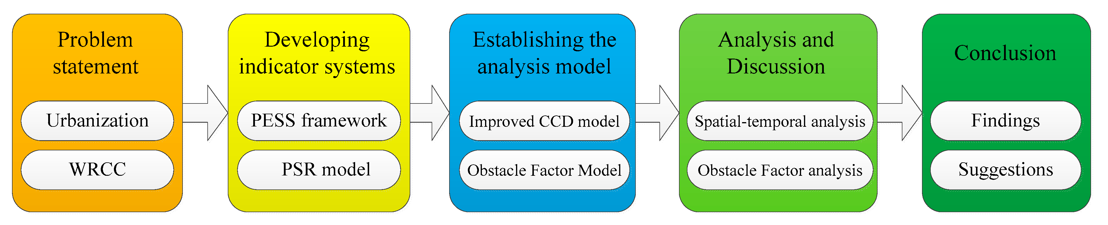
2. Materials and Methods
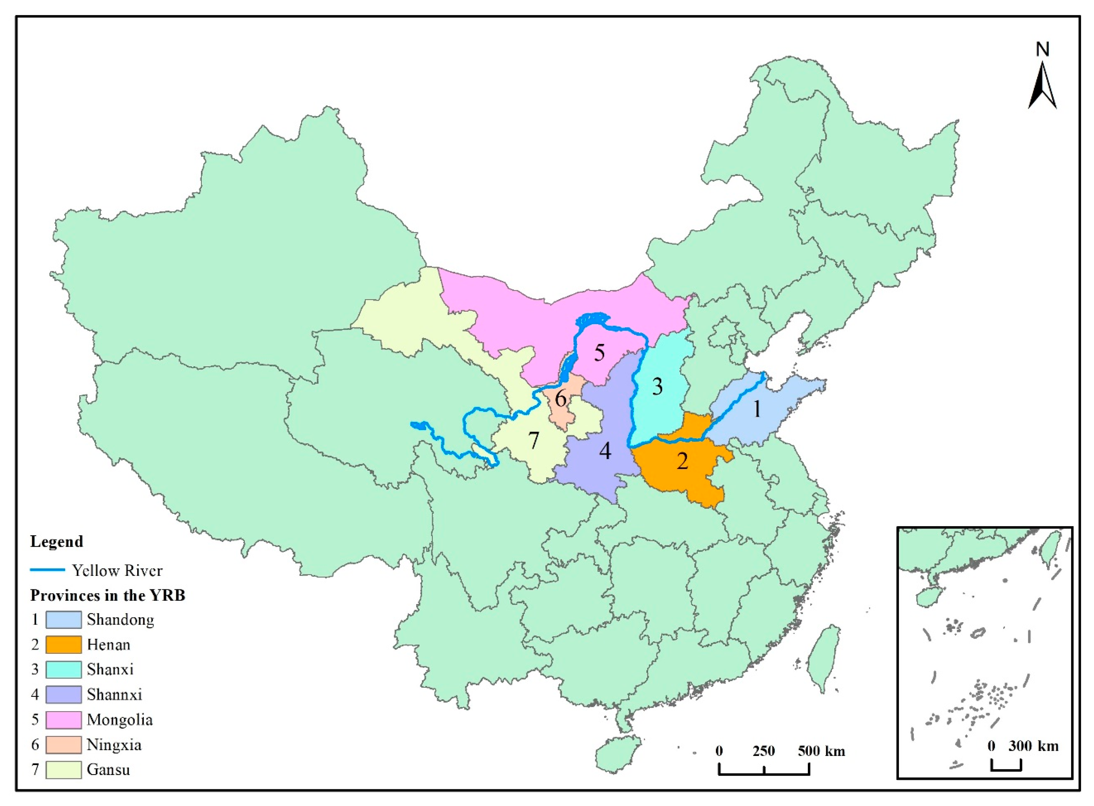
2.1. Study Area and Data
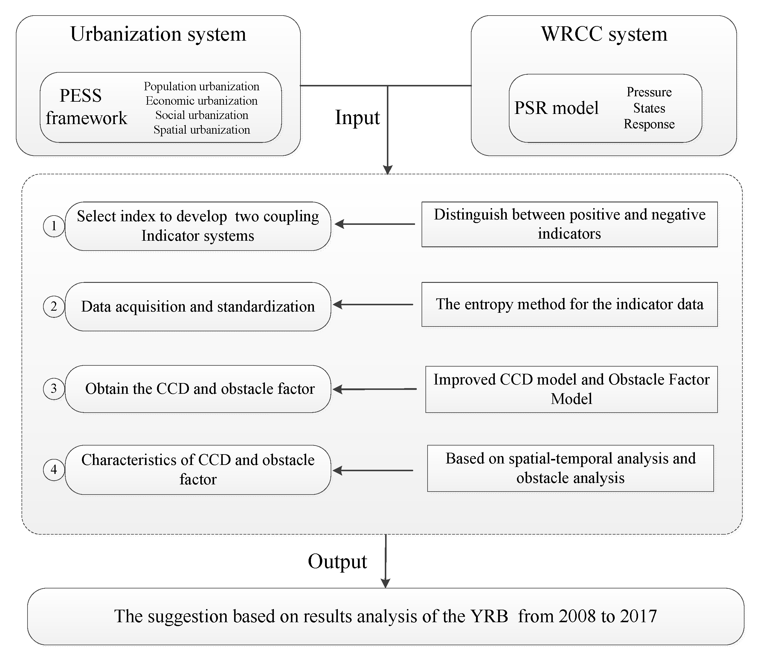
2.2. Index System and Weights
2.2.1. PESS Framework
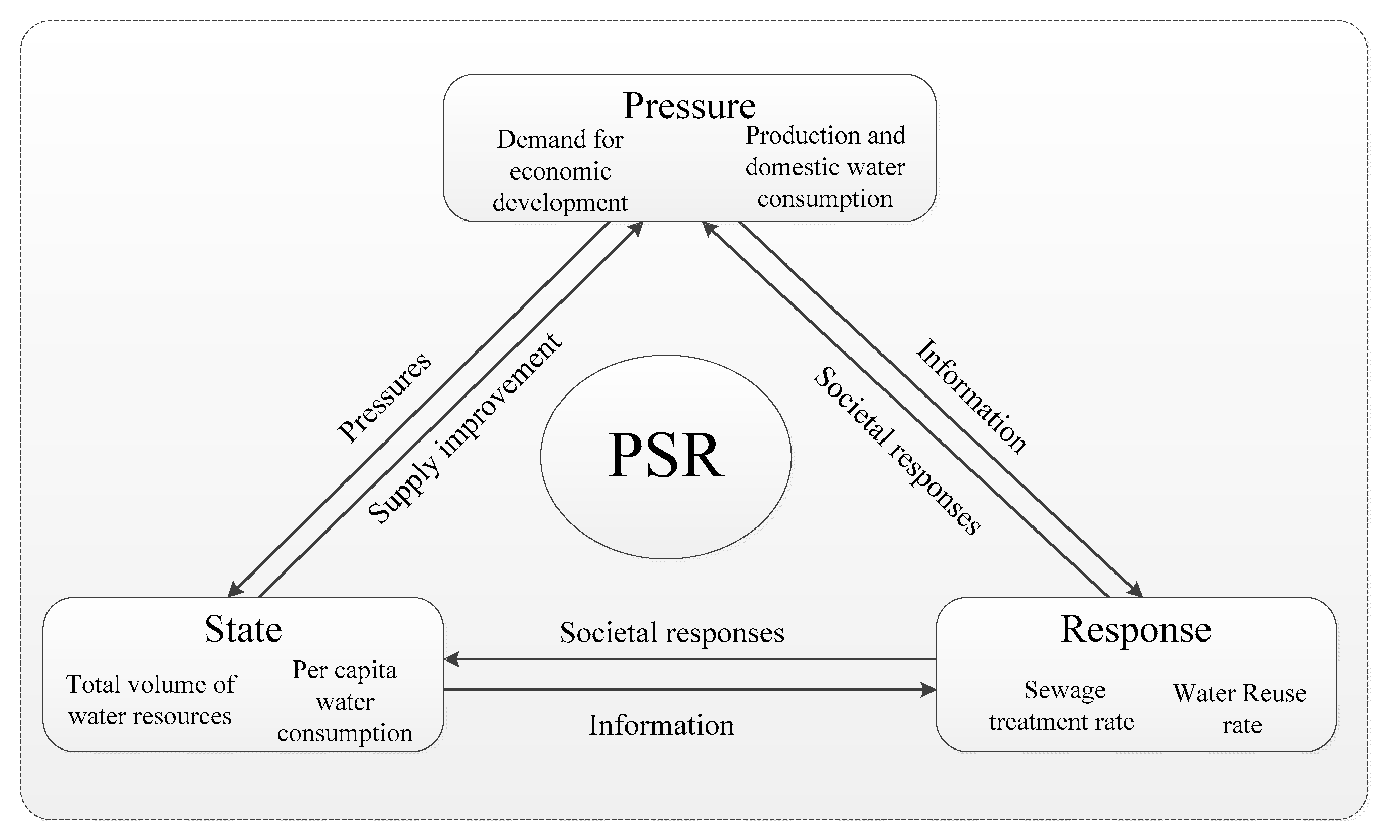
2.2.2. PSR Model
2.3. Data Sources and Preprocessing
2.4. The Improved CCD Model
2.5. Obstacle Factor Model
3. Results Analysis and Discussion
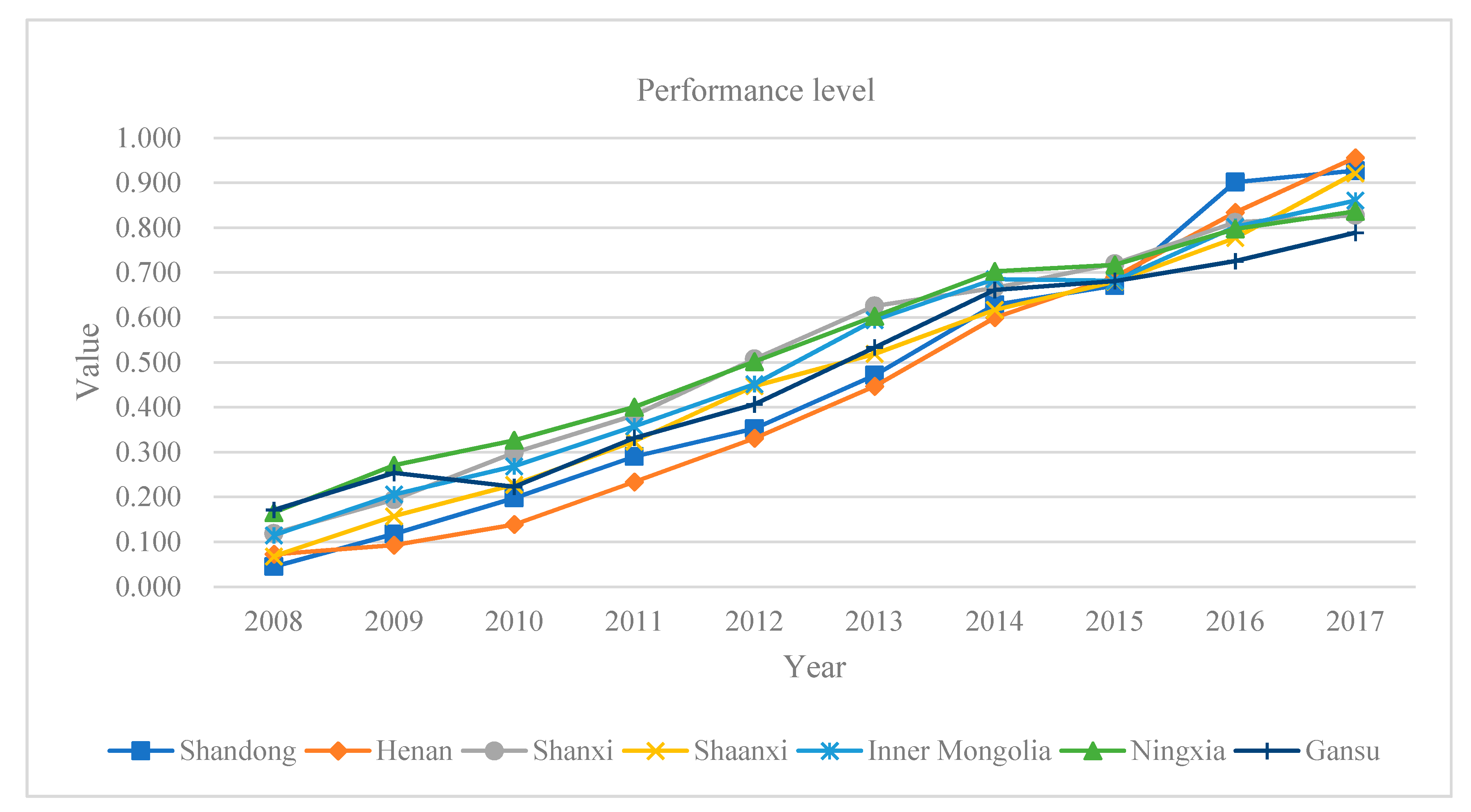
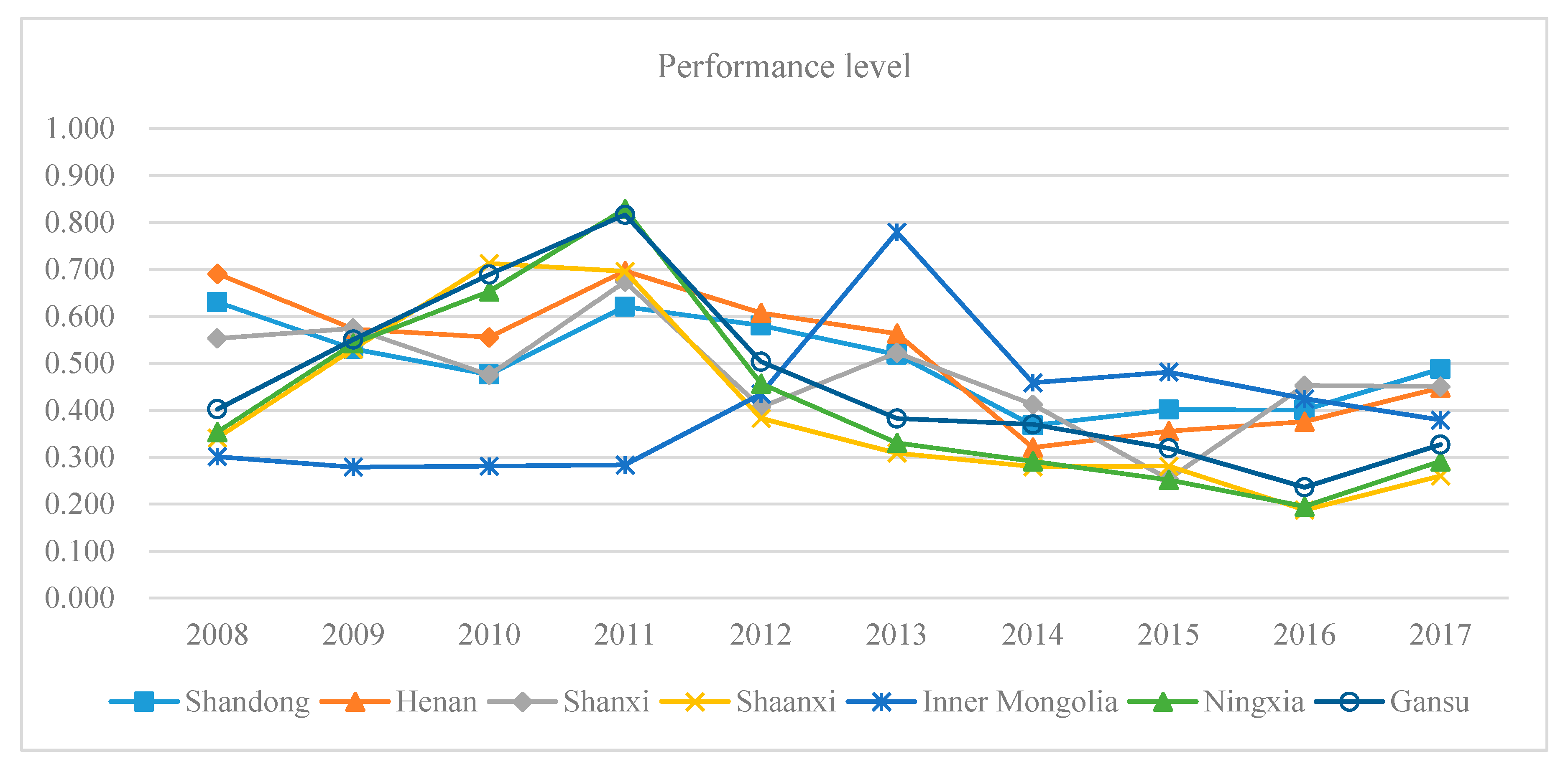
3.1. Trend Analysis of Urbanization and WRCC
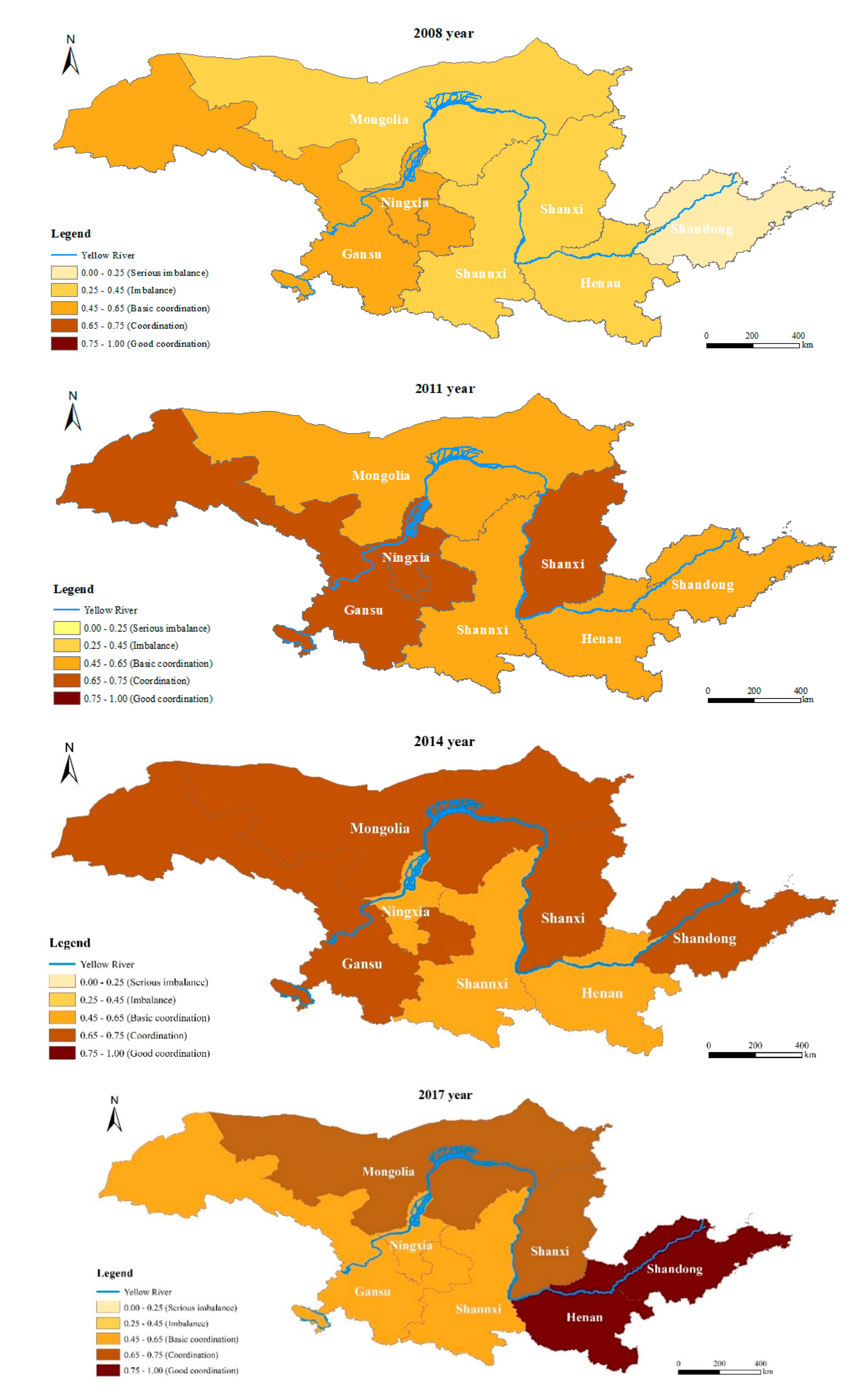
3.2. The Spatial Characteristics Analysis Based on CCD
3.3. The Temporal Characteristics Analysis Based on CCD
- (1)
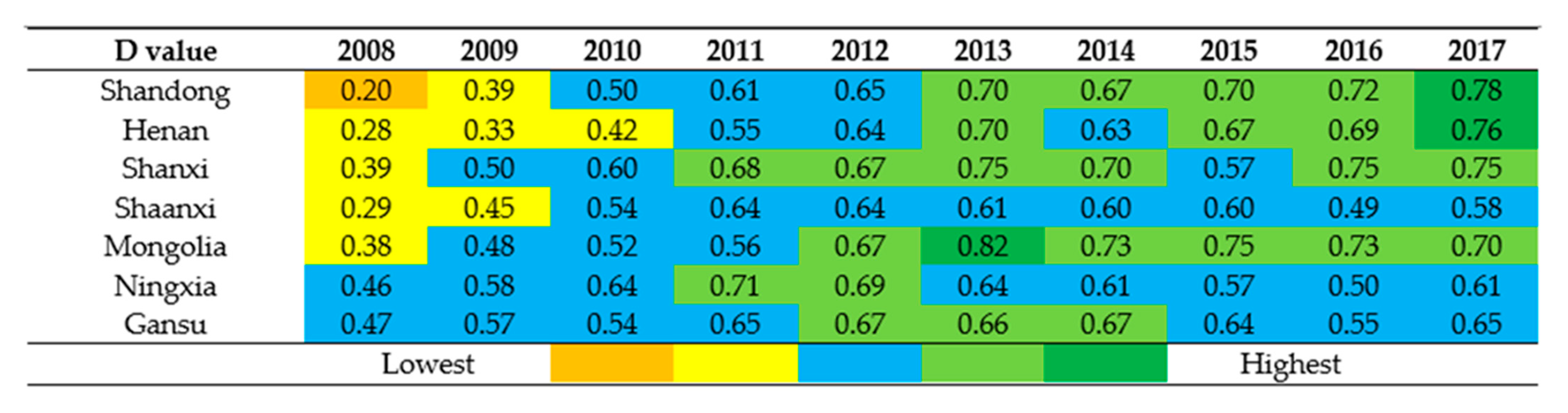
- From 2008 to 2011: The coordination state of urbanization and WRCC system was in an imbalanced state or even worse. Nevertheless, the situation would be improved in the next three years. In 2008, the lowest performance level of the urbanization system and the quality of the WRCC varied considerably, causing the gap between the D value of the seven provinces. From 2009 to 2011, in the rapidly changing urbanization process, the WRCC was adequate to satisfy the requirement of urbanization development. The coordination state of the two systems then began to be significantly improved; each province’s CCD achieved the state of basic coordination or coordination.
- (2)
- From 2011 to 2014: The CCD of the seven provinces were in or close to the coordination state. The coordination state of seven provinces remained in the same state from 2011 to 2014, including Shanxi, Shanxi, and Gansu. For example, the other provinces’ coordination state (e.g., Henan and Inner Mongolia) experienced continued improvement from 2011–2013 but declined in 2014. Overall, the connection between the two investigated systems was gradually strengthened, and the coordination state started to be slowly improved.
- (3)
- From 2014 to 2017: During this period, the CCD remained in a relatively stable state, except for the constant improvement of coordination in some areas. Since 2014, the Chinese Government has tried to protect the resource and environment to the best of its ability and adopted a series of resource and environmental protection measures, such as sponge-city construction, sewage treatment plant alterations, and rainwater and sewage diversion, in order to improve the WRCC. To a certain extent, these situations made it possible to ensure the two systems’ coordinated development. It was virtually impossible to synchronize the development of the urbanization and WRCC due to the shortage of water resources in the YRB. This problem resulted in the failure of the two systems to achieve high-quality development and maintain a state of good coordination. After the operation of the south-to-north water diversion project in 2014, Henan and Shandong experienced an improved WRCC. The coordination state of the two provinces was in or close to a good coordination state. Undeniably, the seven provinces’ coordination state was on a different level in 2017; some provinces will need continuous improvements in the future.
3.4. Obstacle Factor Analysis of the Urbanization System and the WRCC System
3.4.1. Subsystem Obstacle Factors
3.4.2. Obstacle Factors of Index
3.5. Discussion
4. Conclusions
Author Contributions
Funding
Institutional Review Board Statement
Informed Consent Statement
Data Availability Statement
Conflicts of Interest
References
- Hu, G.; Wang, P.; Rahman, S.M.; Li, D.; Alam, M.M.; Zhang, J.; Jin, Z.; Fan, A.; Chen, J.; Zhang, A.; et al. Vicissitudes experienced by the oldest urban center in Bangladesh in relation to the migration of the Brahmaputra River. J. Quat. Sci. 2020, 35, 1089–1099. [Google Scholar] [CrossRef]
- Liu, Y.; Gupta, H.; Springer, E.; Wagener, T. Linking science with environmental decision making: Experiences from an integrated modeling approach to supporting sustainable water resources management. Environ. Model. Softw. 2008, 23, 846–858. [Google Scholar] [CrossRef]
- Bai, X.M.; Shi, P.J.; Liu, Y.S. Realizing China’s urban dream. Nature 2014, 509, 158–160. [Google Scholar] [CrossRef] [PubMed] [Green Version]
- Pittock, J. National Climate Change Policies and Sustainable Water Management: Conflicts and Synergies. Ecol. Soc. 2011, 16, 25. [Google Scholar] [CrossRef] [Green Version]
- Global Sustainable Development Report; Department of Economic and Social Affairs, United Nations: New York, NY, USA, 2018.
- Seto, K.C.; Fragkias, M.; Güneralp, B.; Reilly, M.K. A Meta-Analysis of Global Urban Land Expansion. PLoS ONE 2011, 6, e23777. [Google Scholar] [CrossRef]
- Kavitha, B.D.; Smt, N.K. Gayathri, Urbanization in India. Int. J. Sci. Res. Educ. 2017, 5, 6166–6168. [Google Scholar]
- Ahmad, M.; Ahmed, N.; Jabeen, M.; Jabeen, G.; Qamar, S.; Chandio, A.A.; Rehman, A.; Rauf, A. Empirics on heterogeneous links among urbanization, the intensity of electric power consumption, water-based emissions, and economic progress in regional China. Environ. Sci. Pollut. Res. 2020, 27, 38937–38950. [Google Scholar] [CrossRef]
- Chang, Y.J.; Zhu, D.M. Urban water security of China’s municipalities: Comparison, features and challenges. J. Hydrol. 2020, 587, 125023. [Google Scholar] [CrossRef]
- Gerlak, A.K.; Mukhtarov, F. ‘Ways of knowing’ water: Integrated water resources management and water security as complementary discourses. Int. Environ. Agreem.-Polit. Law Econ. 2015, 15, 257–272. [Google Scholar] [CrossRef]
- Truffer, B.; Coenen, L. Environmental innovation and sustainability transitions in regional studies. Reg. Stud. 2012, 46, 1–21. [Google Scholar] [CrossRef]
- Dou, M.; Ma, J.X.; Li, G.Q.; Zuo, Q.T. Measurement and assessment of water resources carrying capacity in Henan Province, China. Water Sci. Eng. 2015, 8, 102–113. [Google Scholar] [CrossRef] [Green Version]
- Gomes, P.I.A.; Wai, O.W.H. Investigation of Long-Term River Water Quality Trends in Hong Kong to Identify Role of Urbanization, Seasons and Pollution Sources. Water Air Soil Pollut. 2020, 231, 1–15. [Google Scholar] [CrossRef]
- Wang, Y.M.; Zhou, X.D.; Bernard, E. Water environment carrying capacity in Bosten Lake basin. J. Clean Prod. 2018, 199, 574–583. [Google Scholar] [CrossRef]
- Chen, H.; Xu, L.; Cao, Q.; Huang, M.; Song, M.; Quan, Q.; Liu, J. Coupling and metabolic analysis of urbanization and environment between two resource-based cities in North China. PeerJ 2019, 7, e6869. [Google Scholar] [CrossRef]
- Ren, Y.; Cao, W.; Zhang, Y.; Su, H.; Wang, X. Temporal and Spatial Coupling Characteristics of Urbanization and Ecological Environment of Three Major Urban Agglomerations in the Yangtze River Economic Belt. Resour. Environ. Yangtze Basin 2019, 28, 2586–2601. [Google Scholar]
- Zhou, D.; Tian, Y.; Jiang, G. Spatio-temporal investigation of the interactive relationship between urbanization and ecosystem services: Case study of the Jingjinji urban agglomeration, China. Ecol. Indic. 2018, 95, 152–164. [Google Scholar] [CrossRef]
- Yan, Z.; Zhou, Z.; Liu, J.; Wang, H.; Li, D. Water use characteristics and impact factors in the Yellow River basin, China. Water Int. 2020, 45, 148–168. [Google Scholar] [CrossRef]
- Jin, F.J.; Ma, L.; Xu, D. Environmental stress and optimized path of industrial development in the Yellow River Basin. Resour. Sci. 2020, 42, 127–136. [Google Scholar] [CrossRef]
- Marlow, D.R.; Moglia, M.; Cook, S.; Beale, D.J. Towards sustainable urban water management: A critical reassessment. Water Res. 2013, 47, 7150–7161. [Google Scholar] [CrossRef]
- Wang, S.; Fang, C.; Wang, Y.; Huang, Y.; Ma, H. Quantifying the relationship between urban development intensity and carbon dioxide emissions using a panel data analysis. Ecol. Indic. 2015, 49, 121–131. [Google Scholar] [CrossRef]
- Grossman, G.M.; Krueger, A.B. Environmental Impacts of a North American Free Trade Agreement. In Conference on the Mexico-US Free Trade Agreement; Brown University: Providence, RI, USA, 1993. [Google Scholar]
- Balado-Naves, R.; Baños-Pino, J.F.; Mayor, M. Do countries influence neighbouring pollution? A spatial analysis of the EKC for CO2 emissions. Energy Policy 2018, 123, 266–279. [Google Scholar] [CrossRef]
- Ngarava, S.; Zhou, L.; Ayul, J.; Tatsvarei, S. Achieving food security in a climate change environment: Considerations for Environmental Kuznets Curve use in the South African agricultural sector. Climate 2019, 7, 108. [Google Scholar] [CrossRef] [Green Version]
- Martínez-Zarzoso, I. The impact of urbanization on CO2 emissions: Evidence from developing countries. Ecol. Econ. 2011, 70, 1344–1353. [Google Scholar] [CrossRef] [Green Version]
- Liu, Y.; Ji, G.; Luo, Z.; Luo, M. Pollution control effects of the east route of the South-to-North Water Diversion Project on environment and economy of Shandong. China Popul. Resour. Environ. 2020, 30, 73–81. [Google Scholar]
- Bartz, S.; Kelly, D.L. Economic growth and the environment: Theory and facts. Resour. Energy Econ. 2008, 30, 115–149. [Google Scholar] [CrossRef] [Green Version]
- Ozturk, I.; Al-Mulali, U. Investigating the validity of the environmental Kuznets curve hypothesis in Cambodia. Ecol. Indic. 2015, 57, 324–330. [Google Scholar] [CrossRef]
- Zhao, Y.; Wang, S.; Zhou, C. Understanding the relation between urbanization and the eco-environment in China’s Yangtze River Delta using an improved EKC model and coupling analysis. Sci. Total Environ. 2016, 571, 862–875. [Google Scholar] [CrossRef]
- Haken, H. Erfolgsgeheimnisse der Natur Synergetik: Die Lehre vom Zusammenwirken; Shanghai Translation Press: Shanghai, China, 2013. [Google Scholar]
- Haken, H. Adanced Synergetics; Springer: Berlin, Germany, 1983. [Google Scholar]
- Haken, H. Synergetics: An Introduction. Non-Equilibrium Phase Transition and Selforganisation in Physics, Chemistry and Biology; Springer: Berlin, Germany, 1983. [Google Scholar]
- San, K.T.; Kaya, C.; Liu, D.K.T.; Ma, T.P.; Shah, P. A new technique for determining the capacitive coupling coefficients in Flash EPROM’s. IEEE Electron Device Lett. 1992, 13, 328–331. [Google Scholar] [CrossRef]
- Larcher, L.; Pavan, P.; Albani, L.; Ghilardi, T. Bias and W/L dependence of capacitive coupling coefficients in floating gate memory cells. IEEE Electron Device Lett. 2001, 48, 2081–2089. [Google Scholar] [CrossRef]
- Komili, S.; Silver, P.A. Coupling and coordination in gene expression processes: A systems biology view. Nat. Rev. Genet. 2008, 9, 38–48. [Google Scholar] [CrossRef]
- Haughton, G.; Hunter, C. Sustainable Cities; Jessica Kingsley Publishers: London, UK, 1996. [Google Scholar]
- Ernst, K.M.; Preston, B.L. Adaptation Opportunities and Constraints in Coupled Systems: Evidence from the U.S. Energy-Water Nexus. Environ. Sci. Policy 2017, 70, 38–45. [Google Scholar] [CrossRef] [Green Version]
- Ariken, M.; Zhang, F.; Liu, K.; Fang, C.; Kung, H. Coupling coordination analysis of urbanization and eco-environment in Yanqi Basin based on multi-source remote sensing data. Ecol. Indic. 2020, 114, 106331. [Google Scholar] [CrossRef]
- Kurniawan, F.; Adrianto, L.; Bengen, D.G.; Prasetyo, L.B. The social-ecological status of small islands: An evaluation of island tourism destination management in Indonesia. Tour. Manag. Perspect. 2019, 31, 136–144. [Google Scholar] [CrossRef]
- Wang, L.; Wang, Y.; Zhang, Y. Coupling coordination degree of urban land use benefit and urbanization: A case of 27 Cites in the Bohai Rim region. Ecol. Econ. 2017, 33, 25–28. [Google Scholar]
- Guo, Y.; Wang, H.; Nijkamp, P.; Xu, J. Space-time changes in interdependent urban-environmental systems: A policy study on the Huai River Basin in China. Habitat Int. 2015, 45, 135–146. [Google Scholar] [CrossRef]
- Fan, Y.; Fang, C.; Zhang, Q. Coupling coordinated development between social economy and ecological environment in Chinese provincial capital cities-assessment and policy implications. J. Clean Prod. 2019, 229, 289–298. [Google Scholar] [CrossRef]
- Yang, C.; Zeng, W.; Yang, X. Coupling coordination evaluation and sustainable development pattern of geo-ecological environment and urbanization in Chongqing municipality, China. Sustain. Cities Soc. 2020, 61, 102271. [Google Scholar] [CrossRef]
- Li, Y.; Li, Y.; Zhou, Y.; Shi, Y.; Zhu, X. Investigation of a coupling model of coordination between urbanization and the environment. J. Environ. Manag. 2012, 98, 127–133. [Google Scholar] [CrossRef]
- He, J.; Wang, S.; Liu, Y.; Ma, H.; Liu, Q. Examining the relationship between urbanization and the eco-environment using a coupling analysis: Case study of Shanghai, China. Ecol. Indic. 2017, 77, 185–193. [Google Scholar] [CrossRef]
- Shen, L.; Huang, Y.; Huang, Z.; Lou, Y.; Ye, G.; Wong, S. Improved coupling analysis on the coordination between socio-economy and carbon emission. Ecol. Indic. 2018, 94, 357–366. [Google Scholar]
- Braden, J.B.; Kolstad, C.D. Measuring the Demand for Environmental Quality; Elsevier: Amsterdam, The Netherlands, 1991. [Google Scholar]
- Zhang, K.; Shen, J.; He, R.; Fan, B.; Han, H. Dynamic Analysis of the Coupling Coordination Relationship between Urbanization and Water Resource Security and Its Obstacle Factor. Int. J. Environ. Res. Public Health 2019, 16, 4765. [Google Scholar] [CrossRef] [PubMed] [Green Version]
- Zhang, Z.; Li, Y. Coupling coordination and spatiotemporal dynamic evolution between urbanization and geological hazards–A case study from China. Sci. Total Environ. 2020, 728, 138825. [Google Scholar] [CrossRef] [PubMed]
- Dogan, E.; Turkekul, B. CO2 emissions, real output, energy consumption, trade, urbanization and financial development: Testing the EKC hypothesis for the USA. Environ. Sci. Pollut. Res. 2016, 23, 1203–1213. [Google Scholar] [CrossRef] [PubMed]
- Yang, Y.; Hu, N. The spatial and temporal evolution of coordinated ecological and socioeconomic development in the provinces along the Silk Road Economic Belt in China. Sustain. Cities Soc. 2019, 47, 101466. [Google Scholar] [CrossRef]
- National Bureau of Statistics of China. China Statistics Yearbook (2018); China Statistical Press: Beijing, China, 2018.
- National Developmentand Reform Commission of China. National New Urbanization Report (2018); People’s Publishing House: Beijing, China, 2018.
- The State Council The People’s Republic of China. Water Pollution Prevention Action Plan (GF [2014] No. 39); General Office of the State Council of China: Beijing, China, 2015.
- Di, D.; Wu, Z.; Guo, X.; Lv, C.; Wang, H. Value Stream Analysis and Emergy Evaluation of the Water Resource Eco-Economic System in the Yellow River Basin. Water Sui 2019, 11, 710. [Google Scholar] [CrossRef] [Green Version]
- Huang, J.; Fang, C. Interaction coupling mechanism and regularity analysis of urbanization and ecological environment. Geogr. Res. 2003, 2, 211–220. [Google Scholar]
- Kleniewski, N.; Thomas, A.R. Cities, Change, and Conflict a Political Economy of Urban Life; Wadsworth Cengage Learning: Belmont, CA, USA, 2011. [Google Scholar]
- Chen, M.; Lu, D.; Zha, L. The comprehensive evaluation of China’s urbanization and effects on resources and environment. J. Geogr. Sci. 2010, 20, 17–30. [Google Scholar] [CrossRef]
- Liu, Y.; Yao, C.; Wang, G.; Bao, S. An integrated sustainable development approach to modeling the eco-environmental effects from urbanization. Ecol. Ind. 2011, 11, 1599–1608. [Google Scholar] [CrossRef]
- Wang, Z.; Liang, L.; Sun, Z.; Wang, X. Spatiotemporal differentiation and the factors influencing urbanization and ecological environment synergistic effects within the Beijing-Tianjin-Hebei urban agglomeration. J. Environ. Manag. 2019, 243, 227–239. [Google Scholar]
- Song, M.; Hu, C. A Coupling Relationship between the Eco-Environment Carrying Capacity and New-Type Urbanization: A Case Study of the Wuhan Metropolitan Area in China. Sustainability 2018, 10, 4671. [Google Scholar] [CrossRef] [Green Version]
- Liu, K.; Qiao, Y.; Shi, T.; Zhou, Q. Study on coupling coordination and spatiotemporal heterogeneity between economic development and ecological environment of cities along the Yellow River Basin. Environ. Sci. Pollut. Res. 2020. [Google Scholar] [CrossRef] [PubMed]
- OECD. Core Set of Indicators for Environmental Performance Reviews: A Synthesis Report by the Group on the State of the Environment; Environment Monographs; Organisation for Economic Co-Operation and Development: Paris, France, 1993; Volume 83. [Google Scholar]
- Neri, A.C.; Dupin, P.; Sánchez, L.E. A Pressure-State-Response Approach to Cumulative Impact Assessment. J. Clean Prod. 2016, 126, 288–298. [Google Scholar] [CrossRef]
- Pissourios, I.A. An interdisciplinary study on indicators: A comparative review of quality-of-life, macroeconomic, environmental, welfare and sustainability indicators. Ecol. Ind. 2013, 34, 420–427. [Google Scholar] [CrossRef]
- Das, S.; Pradhan, B.; Shit, P.K.; Alamri, A.M. Assessment of Wetland Ecosystem Health Using the Pressure–State–Response (PSR) Model: A Case Study of Mursidabad District of West Bengal (India). Sustainbility 2020, 12, 5932. [Google Scholar] [CrossRef]
- Dong, G.; Shen, J.; Jia, Y.; Sun, F. Comprehensive Evaluation of Water Resource Security: Case Study from Luoyang City, China. Water Sui 2018, 10, 1106. [Google Scholar] [CrossRef]
- Zhao, Y.W.; Zhou, L.Q.; Dong, B.Q.; Dai, C. Health assessment for urban rivers based on the pressure, state and response framework—A case study of the Shiwuli River. Ecol. Indic. 2019, 99, 324–331. [Google Scholar] [CrossRef]
- Wolfslehner, B.; Vacik, H. Evaluating sustainable forest management strategies with the Analytic Network Process in a Pressure-State-Response framework. J. Environ. Manag. 2008, 88, 1–10. [Google Scholar] [CrossRef]
- National Bureau of Statistics of China. China Statistics Yearbook (2008–2017); China Statistical Press: Beijing, China, 2017.
- National Bureau of Statistics of China. China Urban Statistical Yearbook (2008–2017); China Statistical Press: Beijing, China, 2017.
- National Bureau of Statistics of China. China Water Resources Bulletin (2008–2017); China Water & Power Press: Beijing, China, 2017.
- Gomersall, K. Resettlement practice and the pathway to the urban ideal. Geoforum 2018, 96, 51–60. [Google Scholar] [CrossRef]
- Mahadevan, R.; Sun, Y. Effects of foreign direct investment on carbon emissions: Evidence from China and its Belt and Road countries. J. Environ. Manag. 2020, 276, 111321. [Google Scholar] [CrossRef]
- Osobajo, O.A.; Otitoju, A.; Otitoju, M.A.; Oke, A. The Impact of Energy Consumption and Economic Growth on Carbon Dioxide Emissions. Sustainbility 2020, 12, 7965. [Google Scholar]
- Wang, F.; Wang, Z.; Yang, H.; Zhao, Y.; Zhang, Z.; Li, Z.; Hussain, Z. Copula-Based Drought Analysis Using Standardized Precipitation Evapotranspiration Index: A Case Study in the Yellow River Basin, China. Water Sui 2019, 11, 1298. [Google Scholar] [CrossRef] [Green Version]
- Yin, Y.; Wang, L.; Wang, Z.; Tang, Q.; Piao, S.; Chen, D.; Xia, J.; Conradt, T.; Liu, J.; Wada, Y.; et al. Quantifying Water Scarcity in Northern China Within the Context of Climatic and Societal Changes and South-to-North Water Diversion. Earth’s Future 2020, 8. [Google Scholar] [CrossRef]
- Han, H.; Li, H.; Zhang, K. Spatial-Temporal Coupling Analysis of the Coordination between Urbanization and Water Ecosystem in the Yangtze River Economic Belt. Int. J. Environ. Res. Public Health 2019, 16, 3757. [Google Scholar] [CrossRef] [PubMed] [Green Version]
- Omer, A.; Zhuguo, M.; Zheng, Z.; Saleem, F. Natural and anthropogenic influences on the recent droughts in Yellow River Basin, China. Sci. Total Environ. 2020, 704, 135428. [Google Scholar] [CrossRef] [PubMed]
- Wohlfart, C.; Mack, B.; Liu, G.; Kuenzer, C. Multi-faceted land cover and land use change analyses in the Yellow River Basin based on dense Landsat time series: Exemplary analysis in mining, agriculture, forest, and urban areas. Appl. Geogr. 2017, 85, 73–88. [Google Scholar] [CrossRef]
- Zhang, X.; Kong, Y.; Ding, X. How High-Quality Urbanization Affects Utilization Efficiency of Agricultural Water Resources in the Yellow River Basin under Double Control Action? Sustainability 2020, 12, 2869. [Google Scholar] [CrossRef] [Green Version]
- Zuo, Q.; Hao, M.; Zhang, Z.; Jiang, L. Assessment of the Happy River Index as an Integrated Index of River Health and Human Well-Being: A Case Study of the Yellow River, China. Water Sui 2020, 12, 3064. [Google Scholar]
- Rong, T.; Zhang, P.; Jing, W.; Zhang, Y.; Li, Y.; Yang, D.; Yang, J.; Chang, H.; Ge, L. Carbon Dioxide Emissions and Their Driving Forces of Land Use Change Based on Economic Contributive Coefficient (ECC) and Ecological Support Coefficient (ESC) in the Lower Yellow River Region (1995–2018). Energies 2020, 13, 2600. [Google Scholar] [CrossRef]
- Zhao, J.; Liu, Y.; Zhu, Y.; Qin, S.; Wang, Y.; Miao, C. Spatiotemporal differentiation and influencing factors of the coupling and coordinated development of new urbanization and ecological environment in the Yellow River Basin. Resour. Sci. 2020, 42, 159–171. [Google Scholar] [CrossRef]
- Qu, X.; Chen, Y.; Liu, H.; Xia, W.; Lu, Y.; Gang, D.; Lin, L. A holistic assessment of water quality condition and spatiotemporal patterns in impounded lakes along the eastern route of China’s South-to-North water diversion project. Water Res. 2020, 185, 116275. [Google Scholar] [CrossRef]
- Kim, D.; Onof, C. A stochastic rainfall model that can reproduce important rainfall properties across the timescales from several minutes to a decade. J. Hydrol. 2020, 589, 125150. [Google Scholar] [CrossRef]


| Province | Population (104 Person) | Water Resource Amount (108 m3) | GDP (1012 Yuan) | Non-Agricultural Population Rate (%) | Water Consumption Amount (108 m3) |
|---|---|---|---|---|---|
| Shandong | 10,047 | 343.3 | 7.65 | 61.18 | 212.7 |
| Henan | 9605 | 339.8 | 4.81 | 51.71 | 234.6 |
| Shanxi | 3718 | 121.9 | 1.68 | 58.41 | 74.3 |
| Shaanxi | 3864 | 371.4 | 2.44 | 58.13 | 93.7 |
| Mongolia | 2534 | 461.5 | 1.73 | 62.71 | 192.1 |
| Ningxia | 688 | 14.7 | 0.37 | 58.88 | 66.2 |
| Gansu | 2637 | 333.3 | 0.82 | 47.69 | 112.3 |
| Subsystem | Secondary Indicators | Unit | Direction 1 |
|---|---|---|---|
| Population urbanization | X1 nonagricultural population rate | % | + |
| X3 Population growth rate | % | + | |
| X2 Urban population density | Person/km2 | - | |
| Economic urbanization | X4 GDP per capita | Yuan | + |
| X5Per Capita Disposable Income | Yuan | ||
| X6 Proportion of tertiary industries to GDP | % | + | |
| X7 Per capita investment in fixed assets | 104 Yuan | + | |
| Social urbanization | X8 Per capita education funds | 104 Yuan | + |
| X9 Beds in health care industry per 104 people | Bed | + | |
| X10 Number of public transportation vehicles | Vehicle | + | |
| X11 Number of college students | Person | + | |
| Spatial urbanization | X12 Urban road area per capita | km2/person | + |
| X13 Proportion of built-up areas in total areas | % | + | |
| X14 Park green area per capita | m2/person | + |
| Subsystem | Secondary Indicators | Unit | Direction 1 |
|---|---|---|---|
| Pressure | Y1 Water consumption per unit of GDP | 108 m3 | - |
| Y2 Water consumption of agricultural irrigation | 108 m3 | - | |
| Y3 Water consumption of industrial output | 108 m3 | - | |
| Y4 Household water consumption | 108 m3 | - | |
| Y5 Urban sewage discharge | 108 m3 | - | |
| Y6 Annual precipitation | mm | + | |
| State | Y7 Total volume of water resources | 108 m3 | + |
| Y8 Per capita water occupancy volume | m3 | + | |
| Y9 Per capita water consumption | m3 | + | |
| Y10 Water production coefficient | % | + | |
| Response | Y11 Industrial water pollution control investment | 104 Yuan | + |
| Y12 Urban sewage treatment rate | % | + | |
| Y13 Urban water reuse rate | % | + | |
| Y14 Urban water supply rate | % | + |
| Coordination State | Coupling Level | D Value | Corresponding Color |
|---|---|---|---|
| Serious imbalance | Low coupling | D ≤ 0.25 | |
| Imbalance | Antagonism stage | 0.25 < D ≤ 0.45 | |
| Basic coordination | Running-in stage | 0.45 < D ≤ 0.65 | |
| Coordination | Coupling stage | 0.65 < D ≤ 0.75 | |
| Good coordination | Highly coupling | 0.75 < D ≤ 1 |
| System | Urbanization | WRCC | |||||
|---|---|---|---|---|---|---|---|
| Subsystem | Population Urbanization | Economic Urbanization | Social Urbanization | Spatial Urbanization | Pressure | State | Response |
| Shandong | 0.411 | 0.214 | 0.261 | 0.113 | 0.560 | 0.189 | 0.250 |
| Henan | 0.200 | 0.275 | 0.232 | 0.293 | 0.411 | 0.385 | 0.204 |
| Shanxi | 0.258 | 0.353 | 0.200 | 0.189 | 0.507 | 0.261 | 0.232 |
| Shaanxi | 0.328 | 0.228 | 0.188 | 0.256 | 0.378 | 0.267 | 0.355 |
| Mongolia | 0.228 | 0.325 | 0.259 | 0.188 | 0.366 | 0.547 | 0.087 |
| Ningxia | 0.395 | 0.252 | 0.243 | 0.110 | 0.438 | 0.333 | 0.229 |
| Gansu | 0.363 | 0.252 | 0.198 | 0.187 | 0.445 | 0.274 | 0.281 |
| System | Order | Shandong | Henan | Shanxi | Shaanxi | Inner Mongolia | Ningxia | Gansu |
|---|---|---|---|---|---|---|---|---|
| Urbanization | 1 | X2 | X2 | X3 | X13 | X3 | X3 | X13 |
| 2 | X3 | X13 | X6 | X2 | X6 | X5 | X14 | |
| 3 | X10 | X6 | X7 | X3 | X10 | X8 | X6 | |
| 4 | X1 | X10 | X12 | X9 | X5 | X2 | X9 | |
| 5 | X11 | X14 | X13 | X5 | X13 | X1 | X5 | |
| Water Resource | 1 | Y1 | Y10 | Y11 | Y14 | Y10 | Y11 | Y1 |
| 2 | Y2 | Y1 | Y1 | Y2 | Y3 | Y3 | Y11 | |
| 3 | Y11 | Y7 | Y3 | Y11 | Y7 | Y8 | Y5 | |
| 4 | Y5 | Y5 | Y8 | Y9 | Y8 | Y1 | Y4 | |
| 5 | Y13 | Y8 | Y7 | Y3 | Y9 | Y7 | Y12 |
Publisher’s Note: MDPI stays neutral with regard to jurisdictional claims in published maps and institutional affiliations. |
© 2021 by the authors. Licensee MDPI, Basel, Switzerland. This article is an open access article distributed under the terms and conditions of the Creative Commons Attribution (CC BY) license (http://creativecommons.org/licenses/by/4.0/).
Share and Cite
Qiao, R.; Li, H.; Han, H. Spatio-Temporal Coupling Coordination Analysis between Urbanization and Water Resource Carrying Capacity of the Provinces in the Yellow River Basin, China. Water 2021, 13, 376. https://doi.org/10.3390/w13030376
Qiao R, Li H, Han H. Spatio-Temporal Coupling Coordination Analysis between Urbanization and Water Resource Carrying Capacity of the Provinces in the Yellow River Basin, China. Water. 2021; 13(3):376. https://doi.org/10.3390/w13030376
Chicago/Turabian StyleQiao, Ran, Huimin Li, and Han Han. 2021. "Spatio-Temporal Coupling Coordination Analysis between Urbanization and Water Resource Carrying Capacity of the Provinces in the Yellow River Basin, China" Water 13, no. 3: 376. https://doi.org/10.3390/w13030376
APA StyleQiao, R., Li, H., & Han, H. (2021). Spatio-Temporal Coupling Coordination Analysis between Urbanization and Water Resource Carrying Capacity of the Provinces in the Yellow River Basin, China. Water, 13(3), 376. https://doi.org/10.3390/w13030376