
Using AHP and Spatial Analysis to Determine Water Surface Storage Suitability in Cambodia


Abstract
1. Introduction
2. Literature Review
2.1. Water Harvesting Reservoirs
2.2. Water Harvesting in Cambodia
3. Study Area
4. Methods
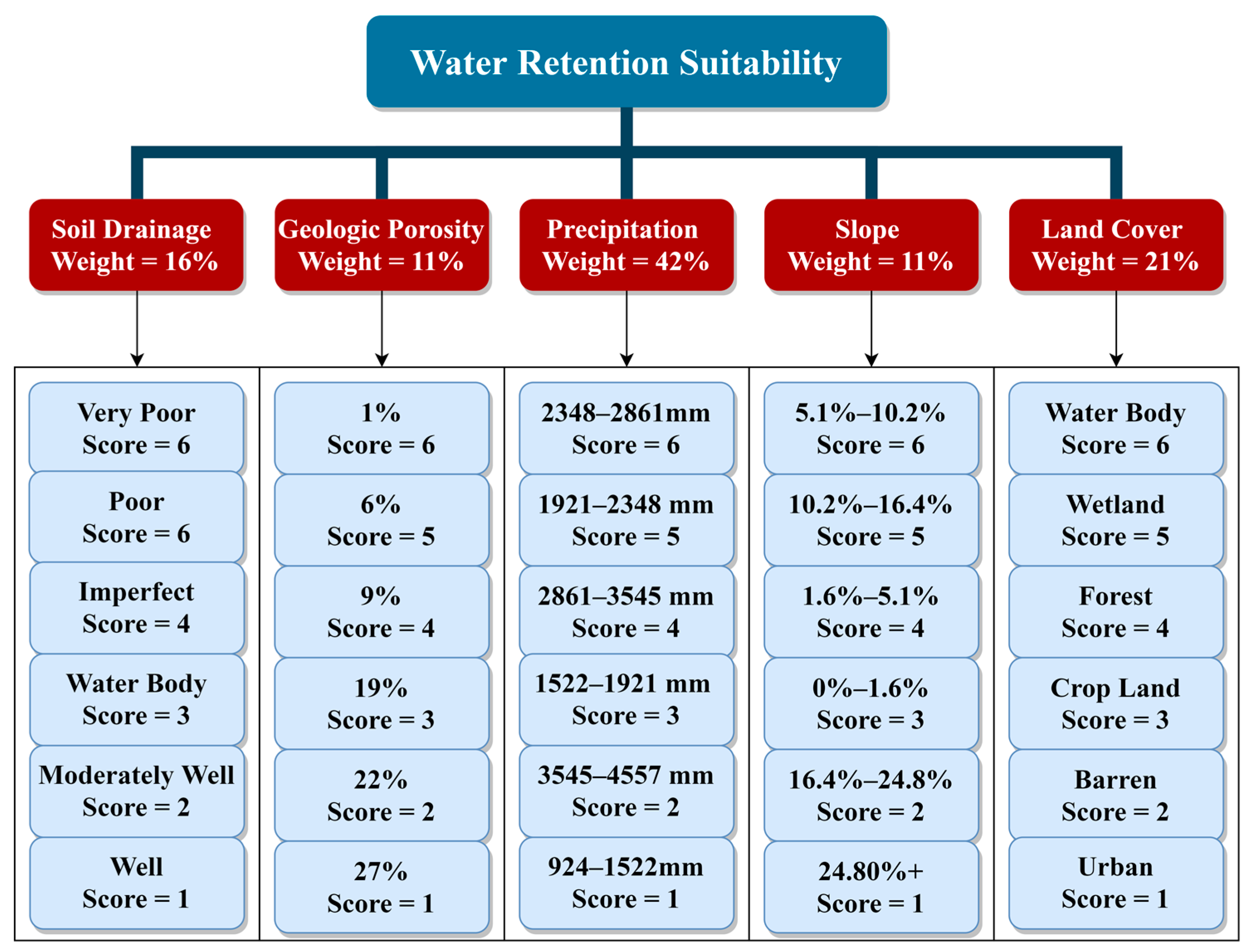
4.1. Phase 1—Decomposition
4.1.1. Soil Drainage
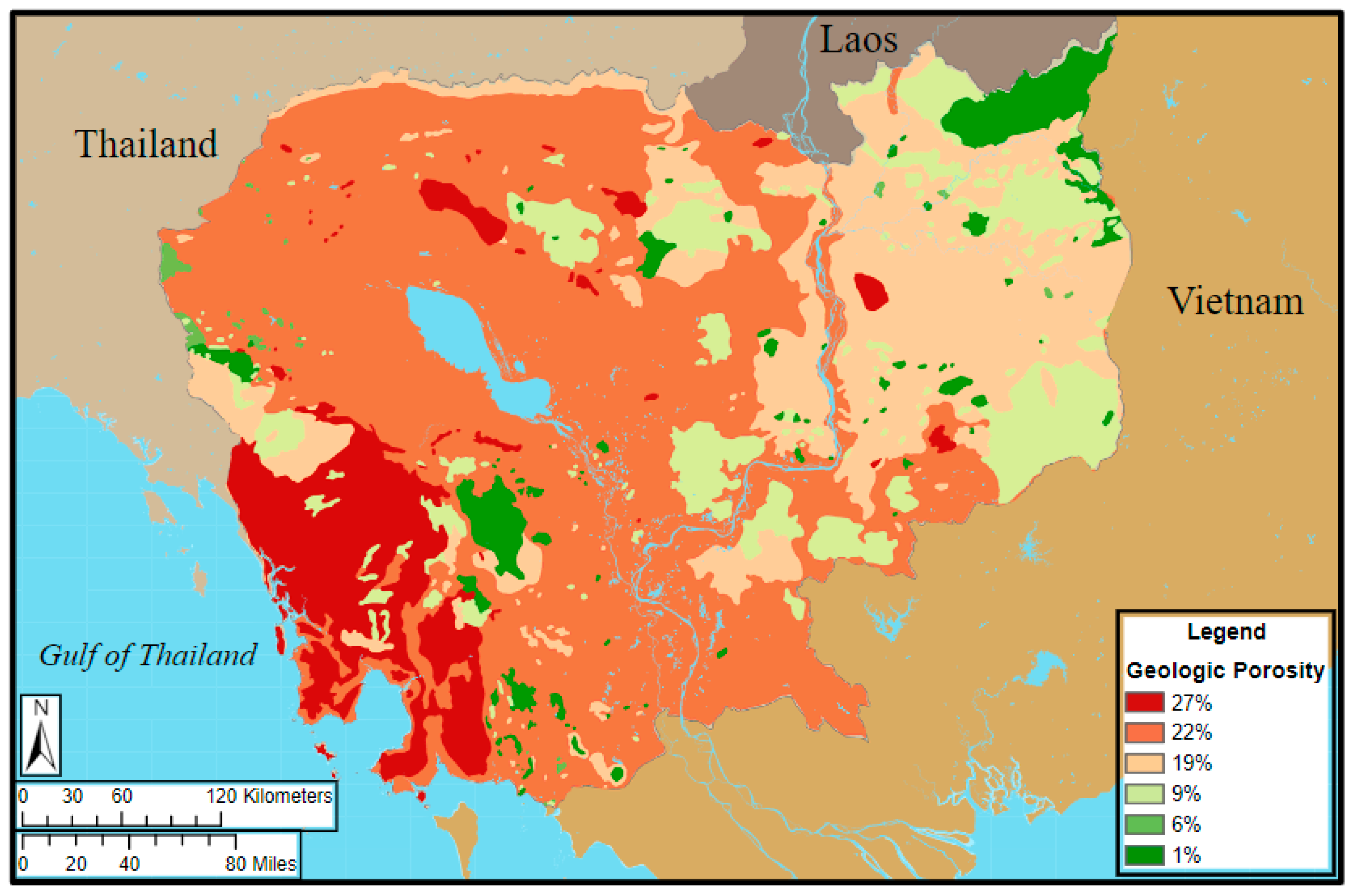
4.1.2. Geologic Porosity
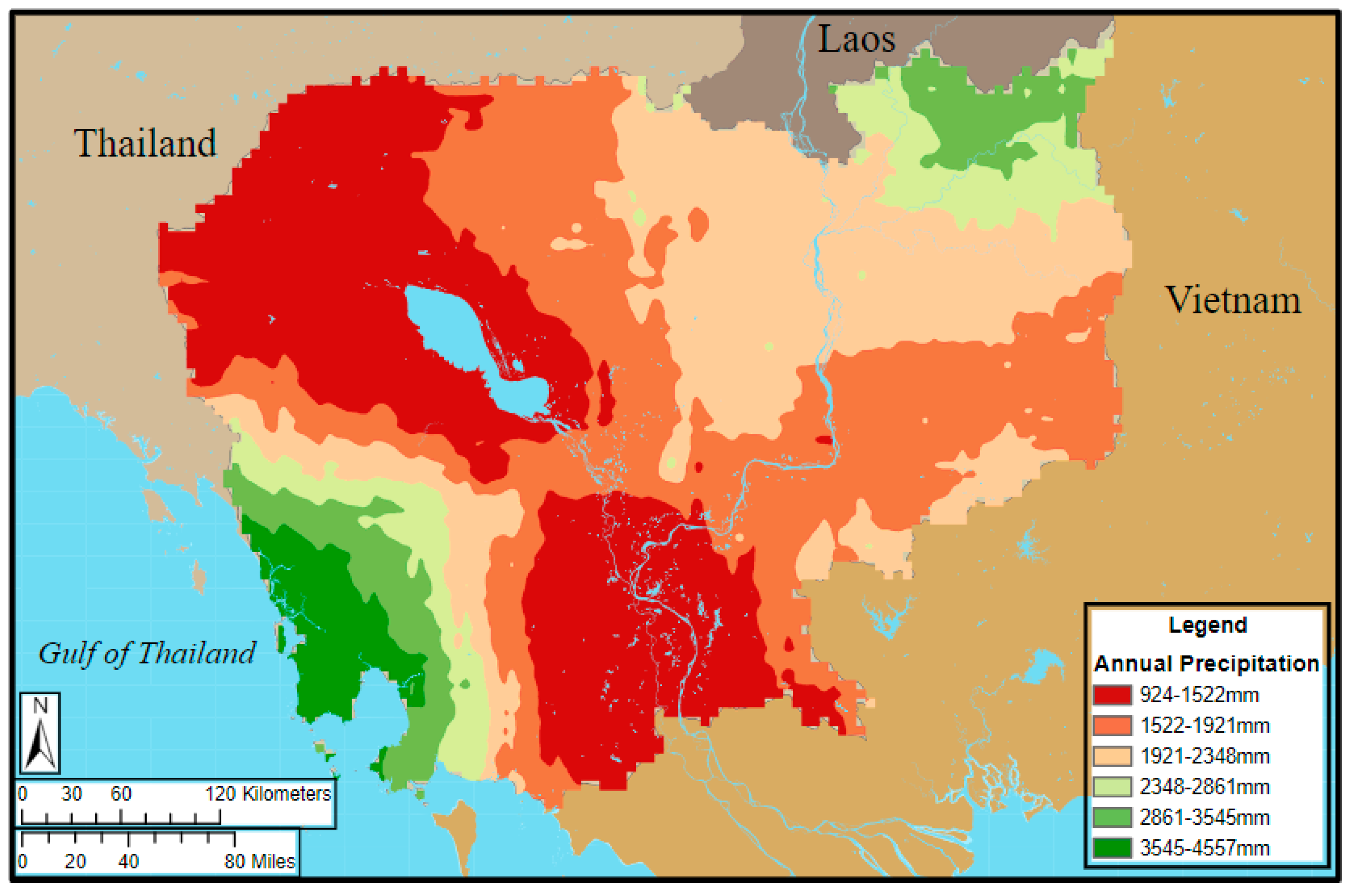
4.1.3. Precipitation
4.1.4. Slope
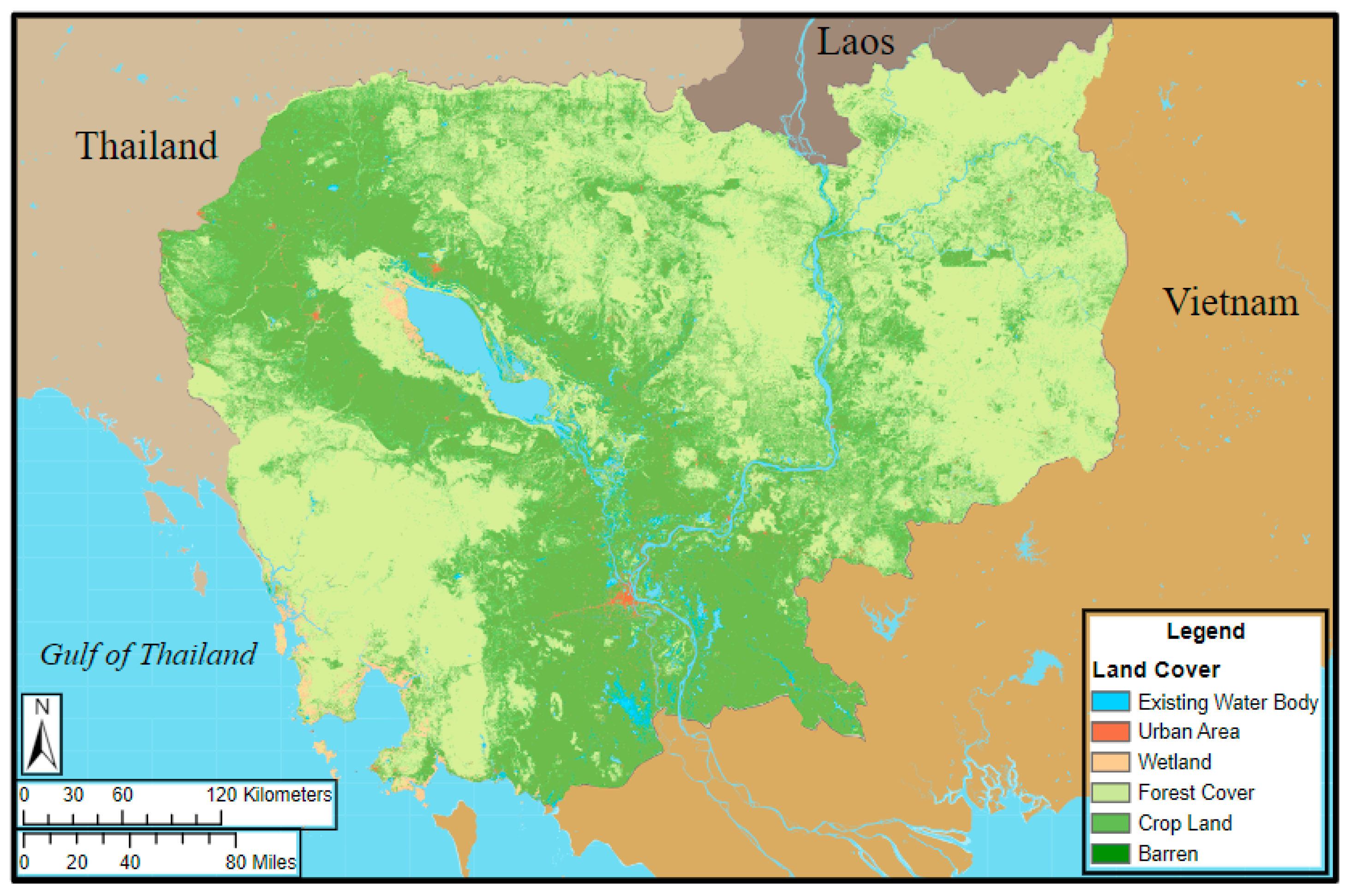
4.1.5. Land Cover
4.2. Phase 2—Prioritization
- (1)
- actively working in the field of civil engineering, water resources, geology, hydrogeology, hydrology, or environmental sciences,
- (2)
- have at least five years of work experience in their field,
- (3)
- Possess a college degree or higher.
4.3. Phase 3—Synthesis
4.4. Restricted Areas
4.5. Model Reliability
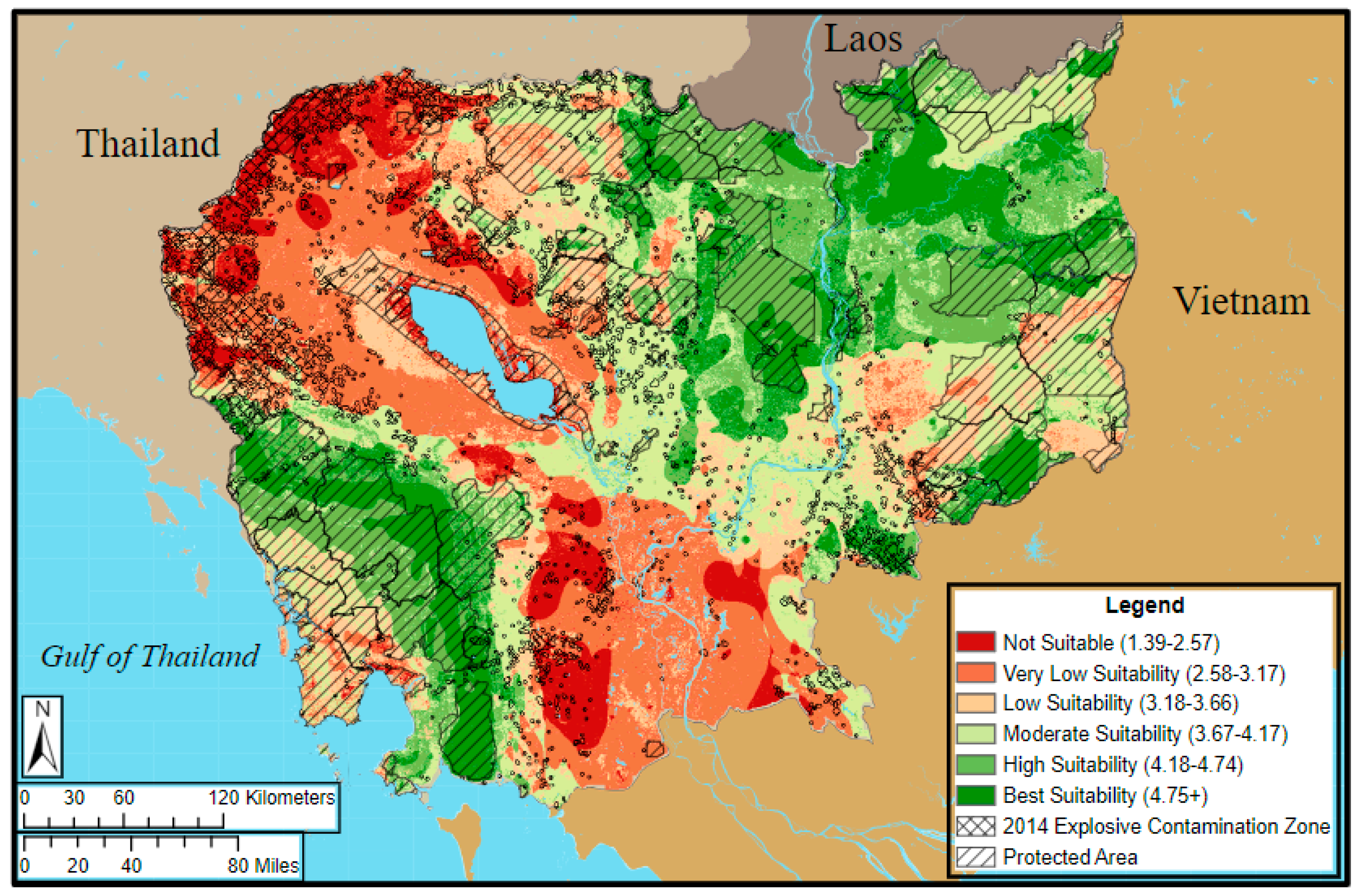
5. Results and Discussion
5.1. AHP Model
5.2. GIS Model
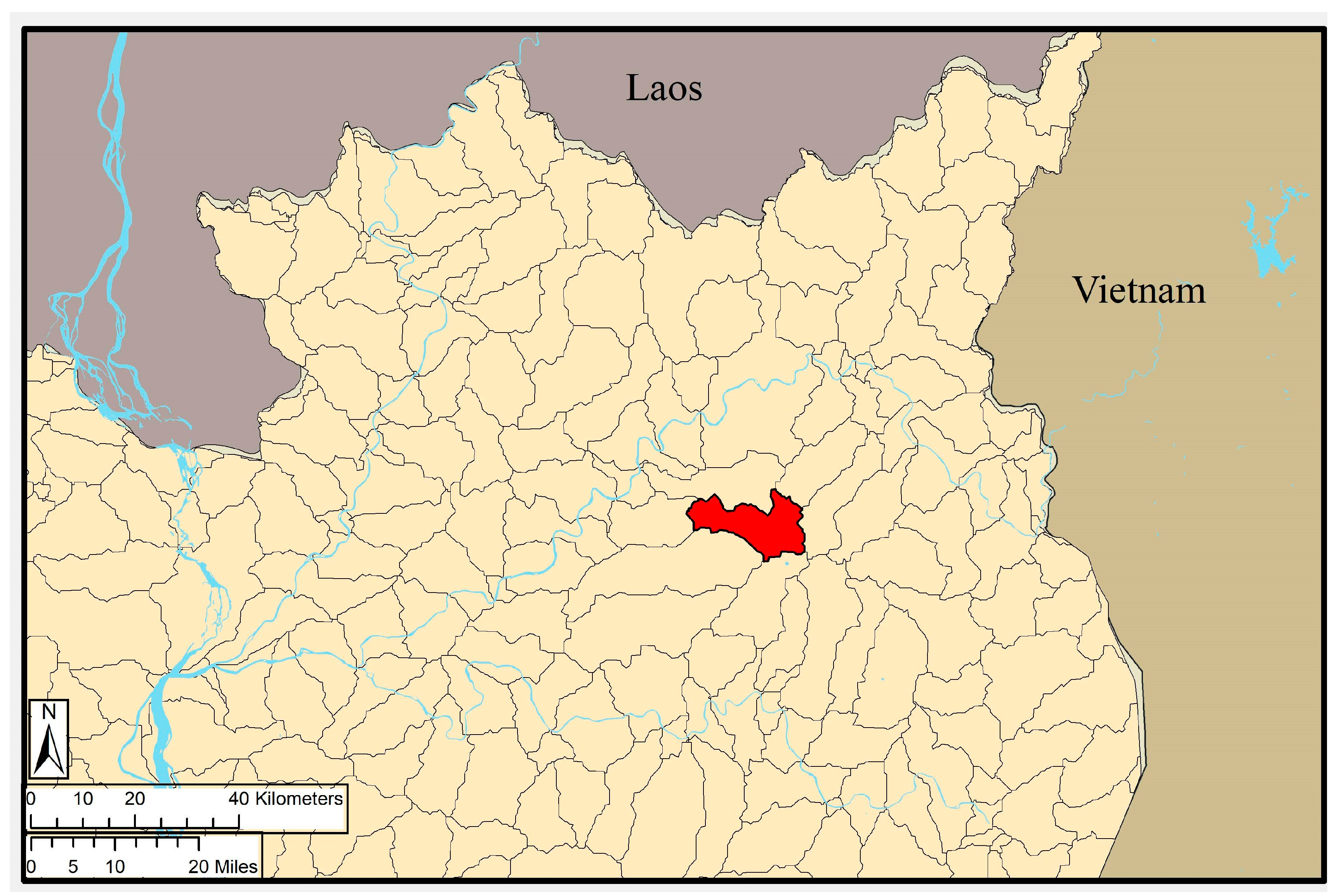
5.3. Simple Watershed Model
5.4. Limitations
5.5. Contributions
6. Conclusions
Supplementary Materials
Author Contributions
Funding
Institutional Review Board Statement
Informed Consent Statement
Data Availability Statement
Acknowledgments
Conflicts of Interest
References
- Asthana, A.N. Is Participatory Water Management Effective? Evidence from Cambodia. Water Policy 2010, 12, 149–164. [Google Scholar] [CrossRef]
- IDMC Cambodia Internal Displacement. Available online: https://www.internal-displacement.org/countries/cambodia (accessed on 23 June 2020).
- Mang, G. Moving Blindly towards Integrated Water Resources Management? Challenges and Constraints Facing Cambodia’s New Water Law. Asia Pac. J. Environ. Law 2009, 12, 21. [Google Scholar]
- Sithirith, M. Water Governance in Cambodia: From Centralized Water Governance to Farmer Water User Community. Resources 2017, 6, 44. [Google Scholar] [CrossRef]
- Ministry of Environment. Synthesis Report on Vulnerability and Adaptation Assessment for Key Sectors Including Strategic and Operational Recommendations; Ministry of Environment: Phnom Penh, Cambodia, 2013.
- Studer, R.; Liniger, H. Water Harvesting: Guidelines to Good Practice; Center for Development and Environment: Bern, Switzerland, 2013. [Google Scholar]
- Critchley, W.; Siegert, K. A Manual for The Design and Construction of Water-Harvesting Schemes for Plant Production; United Nations Food and Agriculture Organization: New York, NY, USA, 1992. [Google Scholar]
- Al-shabeeb, A.R. The Use of AHP within GIS in Selecting Potential Sites for Water Harvesting Sites in the Azraq Basin—Jordan. JGIS 2016, 8, 73–88. [Google Scholar] [CrossRef]
- Aravinda, P.T.; Balakrishna, H.B.; Jayaramu, K.C. Identification of Potential Sites for Detention Ponds along the Vrishabhavathi River. Aquat. Procedia 2015, 4, 585–592. [Google Scholar] [CrossRef]
- Pawattana, C.; Tripathi, N.K. Analytical Hierarchical Process (AHP)-Based Flood Water Retention Planning in Thailand. GISci. Remote Sens. 2008, 45, 343–355. [Google Scholar] [CrossRef]
- Nguyen, H.-Q.; Radhakrishnan, M.; Quang, C.N.X. Urban Retention Basin in a Developing City: From Theoretical Effectiveness to Practical Feasibility. In Proceedings of the 13th International Conference on Urban Drainage, Kuching, Malaysia, 7–12 September 2014. [Google Scholar]
- Saha, A.; Patil, M.; Karwariya, S.; Pingale, S.M.; Azmi, S.; Goyal, V.C.; Rathore, D.S. Identification of Potential Sites for Water Harvesting Structures Using Geospatial Techniques and Multi-Criteria Decision Analysis. Int. Arch. Photogramm. Remote Sens. Spatial Inf. Sci. 2018, 5, 329–334. [Google Scholar] [CrossRef]
- Wu, R.-S.; Molina, G.L.L.; Hussain, F. Optimal Sites Identification for Rainwater Harvesting in Northeastern Guatemala by Analytical Hierarchy Process. Water Resour. Manag. 2018, 32, 4139–4153. [Google Scholar] [CrossRef]
- Day, M.B.; Hodell, D.A.; Brenner, M.; Chapman, H.J.; Curtis, J.H.; Kenney, W.F.; Kolata, A.L.; Peterson, L.C. Paleoenvironmental History of the West Baray, Angkor (Cambodia). Proc. Natl. Acad. Sci. USA 2012, 109, 1046–1051. [Google Scholar] [CrossRef]
- Penny, D.; Pottier, C.; Kummu, M.; Fletcher, R.; Zoppi, U.; Barbetti, M.; Tous, S. Hydrological History of the West Baray, Angkor, Revealed through Palynological Analysis of Sediments from the West Mebon. Bull. Ec. Française Extrême Orient 2005, 92, 497–521. [Google Scholar] [CrossRef]
- Someth, P.; Kubo, N.; Tanji, H. A Combined Technique of Floodplain Storage and Reservoir Irrigation for Paddy Rice Cultivation. Paddy Water Environ. 2007, 5, 101–112. [Google Scholar] [CrossRef]
- Chhuon, K.; Herrera, E.; Nadaoka, K. Application of Integrated Hydrologic and River Basin Management Modeling for the Optimal Development of a Multi-Purpose Reservoir Project. Water Resour. Manag. 2016, 30, 3143–3157. [Google Scholar] [CrossRef]
- Dano, U.; Balogun, A.-L.; Matori, A.-N.; Wan Yusouf, K.; Abubakar, I.; Said Mohamed, M.; Aina, Y.; Pradhan, B. Flood Susceptibility Mapping Using GIS-Based Analytic Network Process: A Case Study of Perlis, Malaysia. Water 2019, 11, 615. [Google Scholar] [CrossRef]
- Oswald Beiler Michelle, R. Treat Christian Integrating GIS and AHP to Prioritize Transportation Infrastructure Using Sustainability Metrics. J. Infrastruct. Syst. 2015, 21, 04014053. [Google Scholar] [CrossRef]
- Romanelli, J.P.; Silva, L.G.M.; Horta, A.; Picoli, R.A. Site Selection for Hydropower Development: A GIS-Based Framework to Improve Planning in Brazil. J. Environ. Eng. 2018, 144, 04018051. [Google Scholar] [CrossRef]
- Peou, H.; Natarajan, I.; Tianhua, H.; Philippe, D. From Conservation to Sustainable Development—A Case Study of Angkor World Heritage Site, Cambodia. J. Environ. Sci. Eng. A 2016, 5, 141–155. [Google Scholar] [CrossRef]
- Peou, H. Sacred Water: Rediscovering the Ancient Hydraulic System of Angkor and Traditional Knowledge of Water Management and Engineering Systems. Int. J. Intang. Herritage 2014, 9, 9. [Google Scholar]
- Saaty, T.L. The Analytic Hierarchy Process: Planning, Priority Setting, Resource Allocation; McGraw-Hill International Book Co: New York, NY, USA, 1980; ISBN 978-0-07-054371-3. [Google Scholar]
- Pavelic, P.; Srisuk, K.; Saraphirom, P.; Nadee, S.; Pholkern, K.; Chusanathas, S.; Munyou, S.; Tangsutthinon, T.; Intarasut, T.; Smakhtin, V. Balancing-out Floods and Droughts: Opportunities to Utilize Floodwater Harvesting and Groundwater Storage for Agricultural Development in Thailand. J. Hydrol. 2012, 470–471, 55–64. [Google Scholar] [CrossRef]
- Sam, S.; Shinogi, Y. Performance Assessment of Farmer Water User Community: A Case Study in Stung Chinit Irrigation System, Cambodia. Paddy Water Environ. 2015, 13, 19–27. [Google Scholar] [CrossRef]
- Räsänen, T.A.; Joffre, O.M.; Paradis, S.; Tran, T.C.; Keskinen, M.; Kummu, M. Model-Based Assessment of Water, Food, and Energy Trade-Offs in a Cascade of Multipurpose Reservoirs: Case Study of the Sesan Tributary of the Mekong River. J. Water Resour. Plan. Manag. 2015, 141, 05014007. [Google Scholar] [CrossRef]
- Clausen, T.J. Technical Annex on Integrated Water Resources Management (IWRM); Asian Development Bank: Phnom Penh, Cambodia, 2009; p. 53. [Google Scholar]
- Erban, L.E.; Gorelick, S.M. Closing the Irrigation Deficit in Cambodia: Implications for Transboundary Impacts on Groundwater and Mekong River Flow. J. Hydrol. 2016, 535, 85–92. [Google Scholar] [CrossRef]
- Mu, E.; Pereyra-Rojas, M. Practical Decision Making; SpringerBriefs in Operations Research, Springer International Publishing: Cham, Switzerland, 2017; ISBN 978-3-319-33860-6. [Google Scholar]
- Food and Agricultural Organization. World Reference Base for Soil Resources 2014: International Soil Classification System for Naming Soils and Creating Legends for Soil Maps; FAO: Rome, Italy, 2014; ISBN 978-92-5-108369-7. [Google Scholar]
- Gleeson, T.; Moosdorf, N.; Hartmann, J.; van Beek, P.H.L. A Glimpse beneath Earth’s Surface: GLobal HYdrogeology MaPS (GLHYMPS) of Permeability and Porosity. Geophys. Res. Lett. 2014. [Google Scholar] [CrossRef]
- Climate Hazards Group UCSB. Cambodia Historic Average Rainfall; CHG: Santa Barabara, CA, USA, 2014. [Google Scholar]
- Save Cambodia’s Wildlife USGS. Geographical Relief of Cambodia. In Atlas of Cambodia; SCW: Phnom Penh, Cambodia, 2013. [Google Scholar]
- Asian Disaster Preparedness Center SERVIR-Mekong. Land Cover in Cambodia (2012–2016); ADPC: Yangon, Myanmar, 2018. [Google Scholar]
- Studer, R.M.; Liniger, H. Water Harvesting: Guidelines to Good Practice; Centre for Development and Environment: Rome, Italy, 2018; ISBN 978-3-905835-35-9. [Google Scholar]
- Fischer, G.; van Velthuizen, H.; Shah, M.; Nachtergaele, F. Global Agro-Ecological Assessment for Agriculture in the 21st Century: Methodology and Results; Food and Agriculture Organization of the United Nations: Rome, Italy, 2002; p. 155. [Google Scholar]
- Natural Resoures Conservation Service. Technical Release 210-60 Earth Dams and Reservoirs; NRCS: Fort Worth, TX, USA, 2019.
- Funk, C.; Peterson, P.; Landsfeld, M.; Pedreros, D.; Verdin, J.; Shukla, S.; Husak, G.; Rowland, J.; Harrison, L.; Hoell, A.; et al. The Climate Hazards Infrared Precipitation with Stations—A New Environmental Record for Monitoring Extremes. Sci. Data 2015, 2, 150066. [Google Scholar] [CrossRef] [PubMed]
- Jenks, G.F. Optimal Data Classification for Choropleth Maps; Department of Geographiy, University of Kansas: Lawrence, KS, USA, 1977. [Google Scholar]
- Food and Agriculture Organization of the United Nations. Country Profile–Cambodia; FAO: Rome, Italy, 2011. [Google Scholar]
- Forman, E.; Peniwati, K. Aggregating Individual Judgments and Priorities with the Analytic Hierarchy Process. Eur. J. Oper. Res. 1998, 108, 165–169. [Google Scholar] [CrossRef]
- Saaty, T.L.; Vargas, L.G. Inconsistency and Rank Preservation. J. Math. Psychol. 1984, 28, 205–214. [Google Scholar] [CrossRef]
- Malczewski, J. GIS and Multicriteria Decision Analysis; John Wiley & Sons: New York, NY, USA, 1999; ISBN 978-0-471-32944-2. [Google Scholar]
- Government of Cambodia. Natural Protected Areas in Cambodia (1993–2018); Government of Cambodia: Phnom Penh, Cambodia, 2015.
- Cambodia Mine Action Center. Ten Years Achievement and Perspective; CMAC: Phnom Penh, Cambodia, 2010.
- Office for the Coordination of Humanitarian Affairs. Baseline Survey on Mine/ERW (2009-2014); OCHA: Phnom Penh, Cambodia, 2014. [Google Scholar]
- Jaafar, H.H.; Ahmad, F.A.; El Beyrouthy, N. GCN250, New Global Gridded Curve Numbers for Hydrologic Modeling and Design. Sci. Data 2019, 6, 145. [Google Scholar] [CrossRef]
- Natural Resoures Conservation Service. Small Watershed Hydrology; NRCS: Washington, DC, USA, 2009.
- Lehner, B. HydroSHEDS Technical Documentation; World Wildlife Fund: Washington, DC, USA, 2013; p. 26. [Google Scholar]
- Cambodia Development Watch. Boeung Kak Lake Lease Agreement; CDW: Phnom Penh, Cambodia, 2007. [Google Scholar]
- World Bank Group. Urban Development in Phnom Penh; World Bank Group: Phnom Penh, Cambodia, 2017. [Google Scholar]
- Yabuta, J. The Study on Integrated Master Plan for Suistainable Development of Siem Reap/Angkor Town in the Kingdom of Cambodia; International Development Center of Japan: Toyko, Japan, 2006. [Google Scholar]
- Le, T.V.H.; Nguyen, H.N.; Wolanski, E.; Tran, T.C.; Haruyama, S. The Combined Impact on the Flooding in Vietnam’s Mekong River Delta of Local Man-Made Structures, Sea Level Rise, and Dams Upstream in the River Catchment. Estuarine Coast. Shelf Sci. 2007, 71, 110–116. [Google Scholar] [CrossRef]
- Buakhao, W.; Kangrang, A. DEM Resolution Impact on the Estimation of the Physical Characteristics of Watersheds by Using SWAT. Available online: https://www.hindawi.com/journals/ace/2016/8180158/ (accessed on 13 September 2020).
- Hoang, L.; Mukundan, R.; Moore, K.E.B.; Owens, E.M.; Steenhuis, T.S. The Effect of Input Data Resolution and Complexity on the Uncertainty of Hydrological Predictions in a Humid Vegetated Watershed. Hydrol. Earth Syst. Sci. 2018, 22, 5947–5965. [Google Scholar] [CrossRef]
- Center for Excellence in Disaster Management & Humanitarian Assistance. Cambodia Disaster Management Reference Handbook; CEDMHA: Ford Island, HI, USA, 2017. [Google Scholar]
- Pengra, B. A Glass Half Empty:Regions at Risk Due to Groundwater Depletion. UN Environ. Program 2012, 2, 117–127. [Google Scholar] [CrossRef]
- Bowen, K.; Miller, F.; Dany, V.; Graham, S. The Relevance of a Coproductive Capacity Framework to Climate Change Adaptation: Investigating the Health and Water Sectors in Cambodia. Ecol. Soc. 2015, 20. [Google Scholar] [CrossRef]
- Liu, J.; Xu, Z.; Chen, F.; Chen, F.; Zhang, L. Flood Hazard Mapping and Assessment on the Angkor World Heritage Site, Cambodia. Remote Sens. 2019, 11, 98. [Google Scholar] [CrossRef]


| Engineering Criterion | Metric Resolution | Imperial Resolution | Database Name | Database Location |
| Soil Drainage [30] | 1000 m × 1000 m | 3280 ft × 3280 ft | Harmonized World Soil Database | Food and Agriculture Organization of the United Nations—Rome, Italy |
| Geologic Porosity [31] | 15 m × 15 m | 50 ft × 50 ft | GLobal HYdrodeology MaPS | University of Victoria—Victoria, British Columbia, Canada |
| Annual Precipitation [32] | 500 m × 500 m | 1640 ft × 1640 ft | Climate Hazards Group InfraRed Precipitation with Station data | University of California Santa Barbara—Santa Barbara, California, USA |
| Slope [33] | 90 m × 90 m | 295 ft × 295 ft | Geographical Relief of Cambodia | Open Development Cambodia—Phnom Penh, Cambodia |
| Land Cover [34] | 250m × 250m | 820ft × 820ft | Regional Land Cover Monitoring System | Asian Disaster Preparedness Center—Yangon, Myanmar |
| Control Criterion | Metric Resolution | Imperial Resolution | Database Name | Database Location |
| Explosion Contamination Zone [35] | N/A | N/A | Baseline Survey on Mine/ERW | Open Development Cambodia—Phnom Penh, Cambodia |
| Protected Areas [36] | N/A | N/A | Natural Protected Areas in Cambodia | Open Development Cambodia—Phnom Penh, Cambodia |
| Watershed Criterion | Metric Resolution | Imperial Resolution | Database Name | Database Location |
| Watersheds [37] | N/A | N/A | HydroSHEDS | World Wildlife Fund—Washington, District of Columbia, USA |
| Curve Number [38] | 250 m × 250 m | 820 ft × 820 ft | Global Curve Number | American University of Beirut—Beirut, Lebanon |
| Role | n |
|---|---|
| Project Manager | 5 |
| Academic | 16 |
| Engineer | 5 |
| Scientist | 5 |
| Criteria | Geologic Porosity | Soil Drainage | Slope Gradient | Annual Rainfall | Land Cover | Weight |
|---|---|---|---|---|---|---|
| Geologic Porosity | 1.00 | 0.97 | 0.79 | 0.22 | 0.48 | 11% |
| Slope Gradient | 1.00 | 1.00 | 0.62 | 0.28 | 0.68 | 11% |
| Soil Drainage | 1.30 | 1.61 | 1.00 | 0.39 | 0.71 | 16% |
| Annual Rainfall | 4.50 | 3.61 | 2.60 | 1.00 | 1.91 | 42% |
| Land Cover | 2.10 | 1.48 | 1.40 | 0.52 | 1.00 | 21% |
| Characteristics | Metric Units | Imperial Units |
|---|---|---|
| Watershed Suitability Score | 4.70 | 4.70 |
| Watershed Area | 163 sq-km | 63 sq-miles |
| Watershed Slope | 2.0% | 2.0% |
| Watershed Curve Number | 80 | 80 |
| 1-yr 24-hr Precipitation | 8.1 cm | 3.2 in |
| Calculated Stormwater Depth | 3.5 cm | 1.4 in |
| Calculated Stormwater Volume | 5,674,000 m3 | 4600 acre-ft |
Publisher’s Note: MDPI stays neutral with regard to jurisdictional claims in published maps and institutional affiliations. |
© 2021 by the authors. Licensee MDPI, Basel, Switzerland. This article is an open access article distributed under the terms and conditions of the Creative Commons Attribution (CC BY) license (http://creativecommons.org/licenses/by/4.0/).
Share and Cite
Ward, M.; Poleacovschi, C.; Perez, M. Using AHP and Spatial Analysis to Determine Water Surface Storage Suitability in Cambodia. Water 2021, 13, 367. https://doi.org/10.3390/w13030367
Ward M, Poleacovschi C, Perez M. Using AHP and Spatial Analysis to Determine Water Surface Storage Suitability in Cambodia. Water. 2021; 13(3):367. https://doi.org/10.3390/w13030367
Chicago/Turabian StyleWard, Michael, Cristina Poleacovschi, and Michael Perez. 2021. "Using AHP and Spatial Analysis to Determine Water Surface Storage Suitability in Cambodia" Water 13, no. 3: 367. https://doi.org/10.3390/w13030367
APA StyleWard, M., Poleacovschi, C., & Perez, M. (2021). Using AHP and Spatial Analysis to Determine Water Surface Storage Suitability in Cambodia. Water, 13(3), 367. https://doi.org/10.3390/w13030367