
Use of Monitoring Approaches to Verify the Predictive Accuracy of the Modeling of Particle-Bound Solid Inputs to Surface Waters

 , and
, and 
Abstract
:1. Introduction
2. Materials and Methods
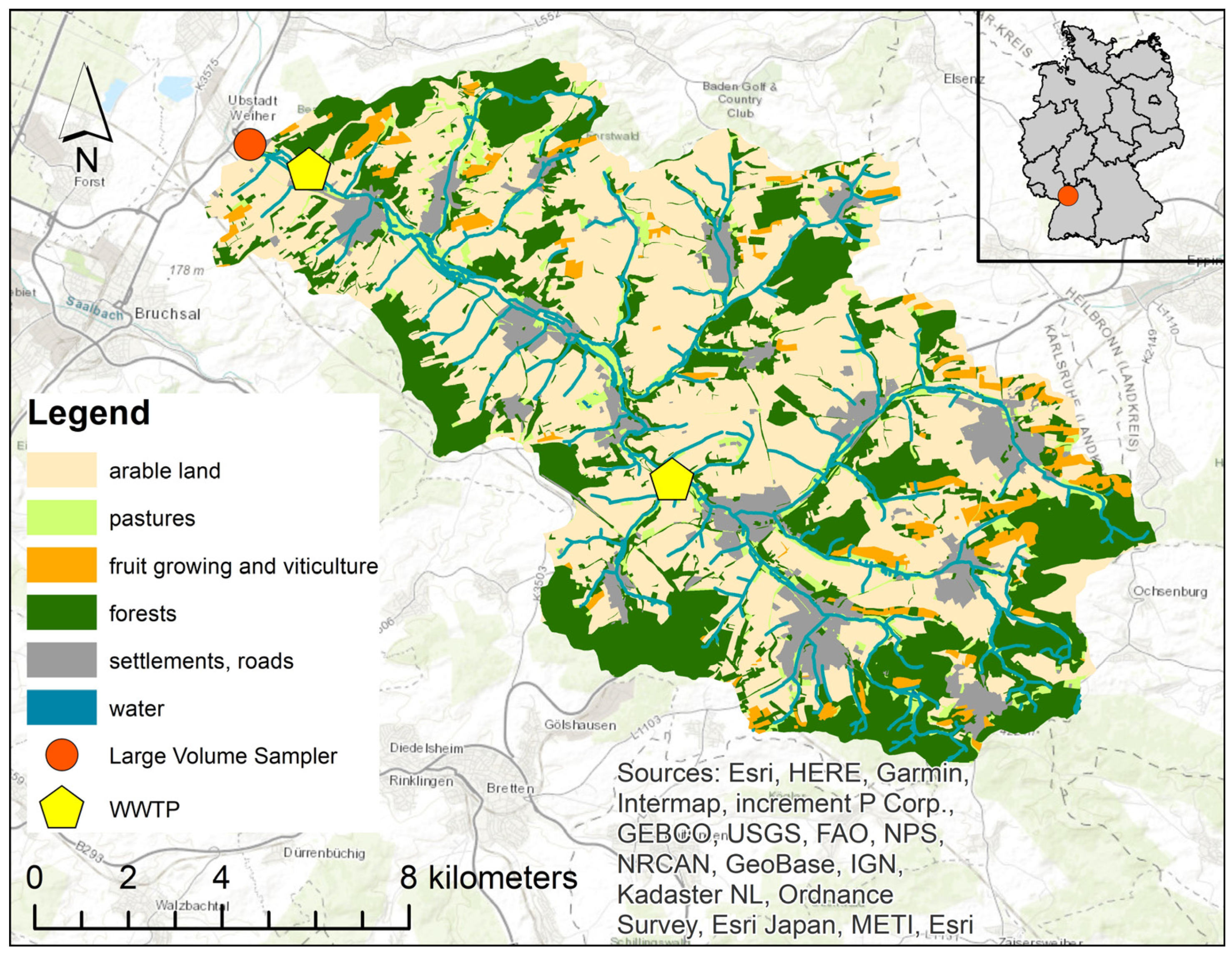
2.1. The Study Area: Kraichbach
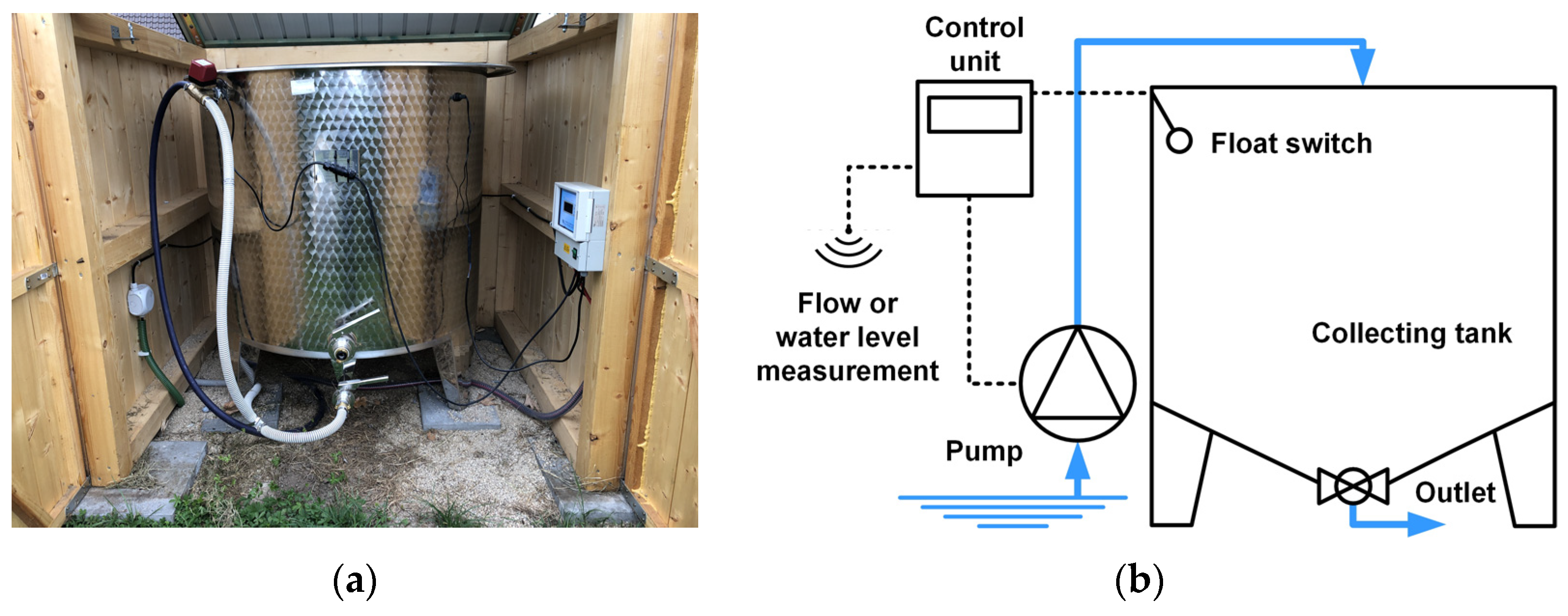
2.2. Monitoring with the Large-Volume Sampler
2.2.1. Monitoring Campaign
2.2.2. Large-Volume Sampler
2.2.3. River Mean Concentrations
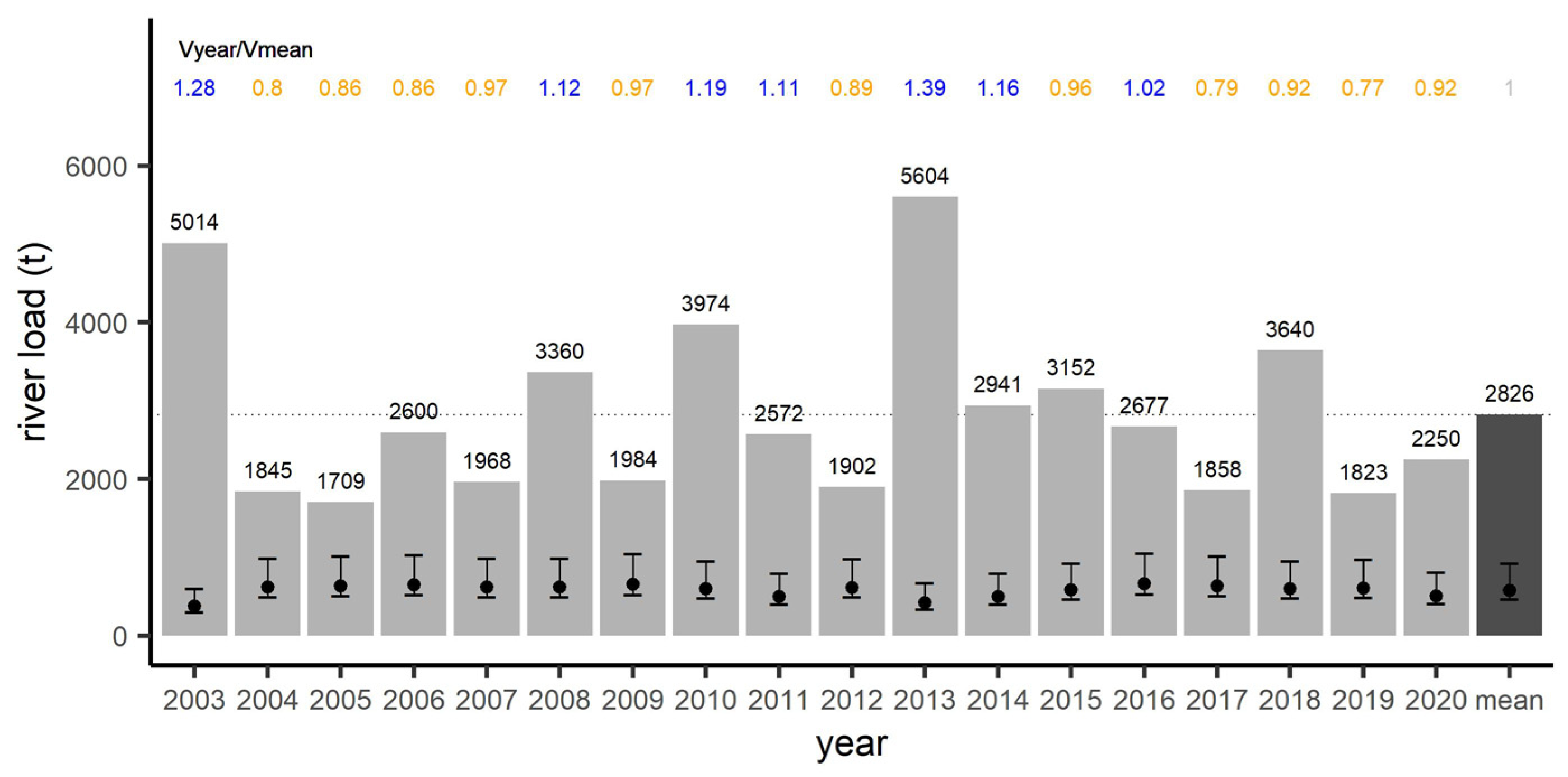
2.2.4. Annual River Loads
2.2.5. Dry-Weather Load
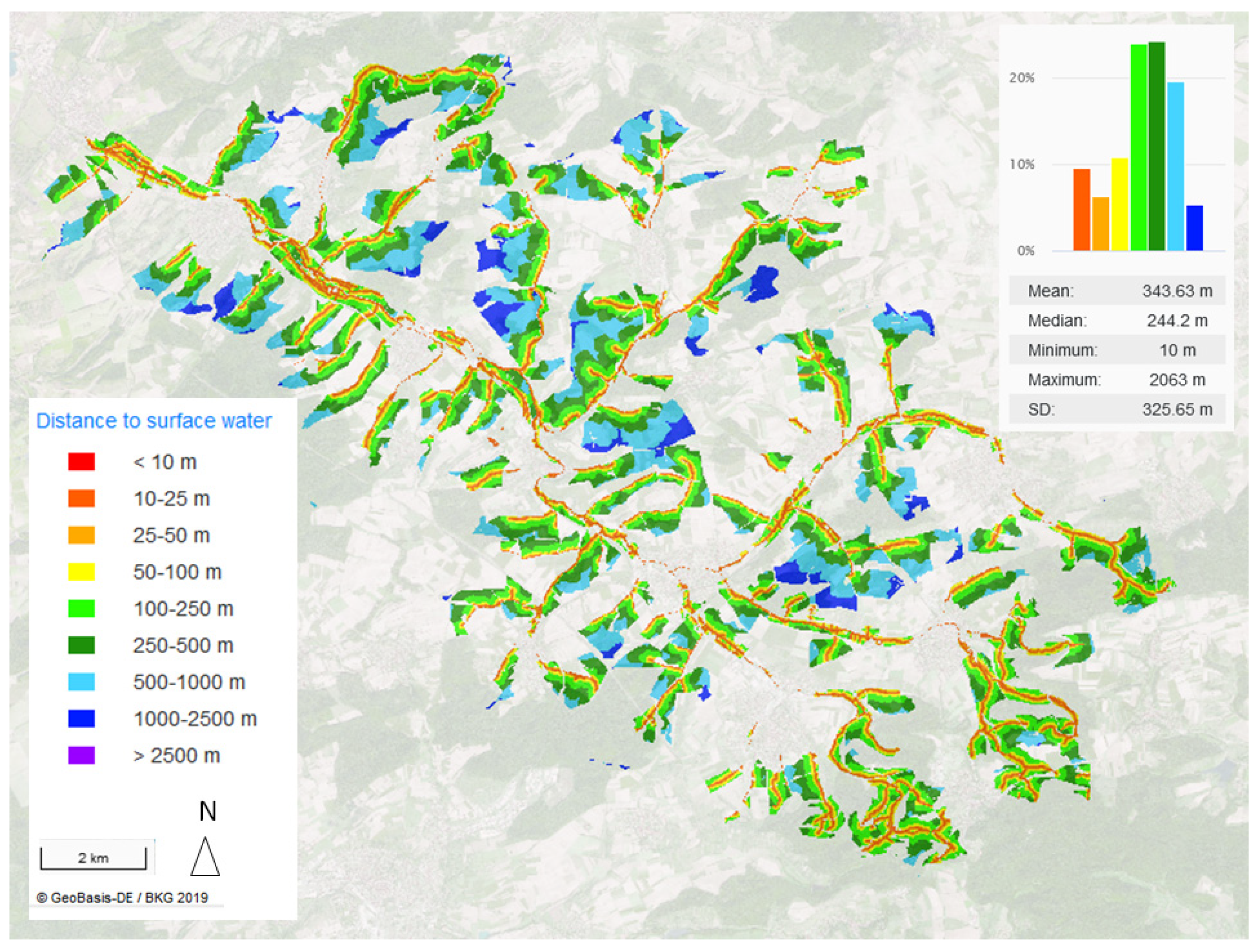
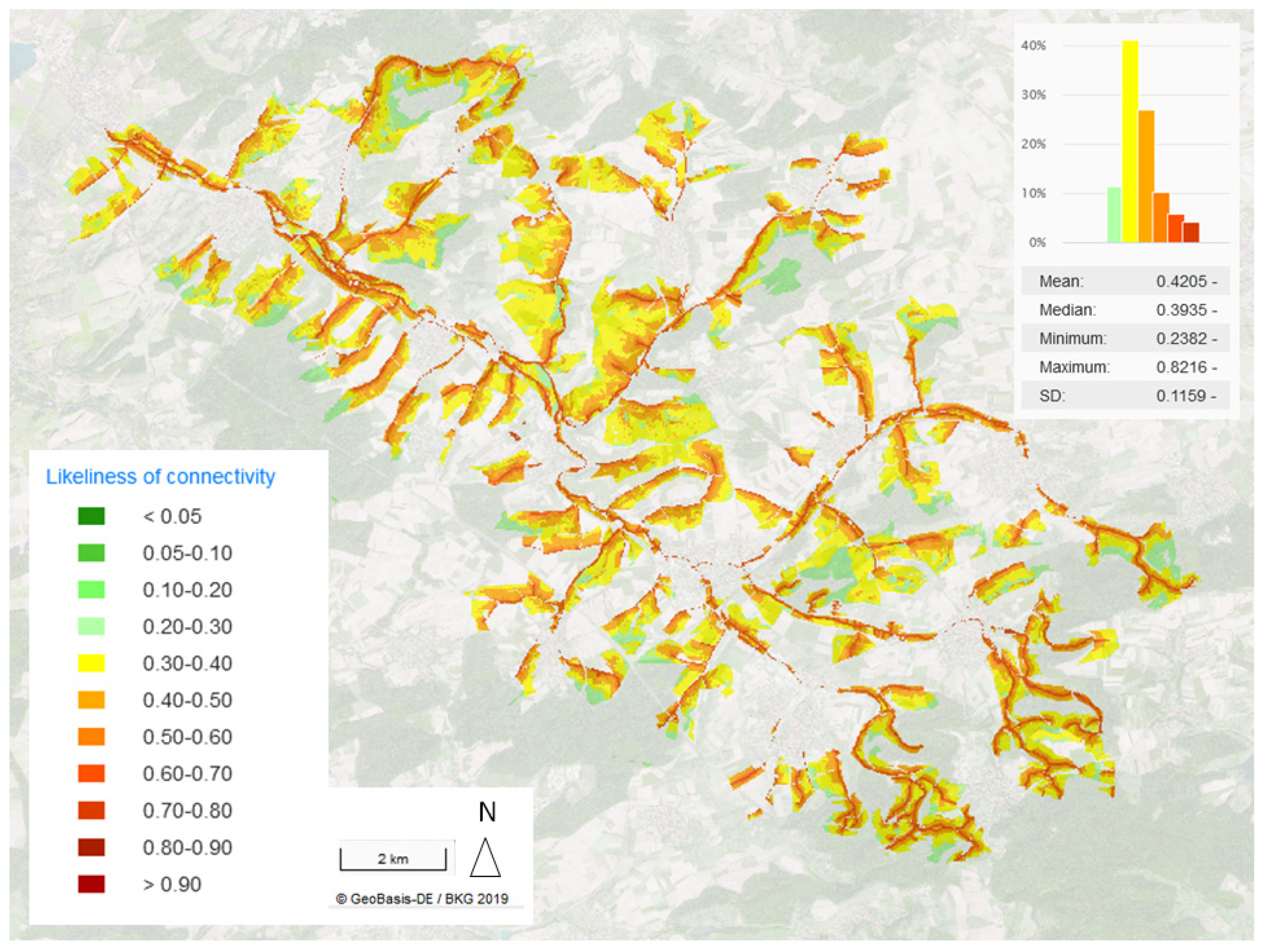
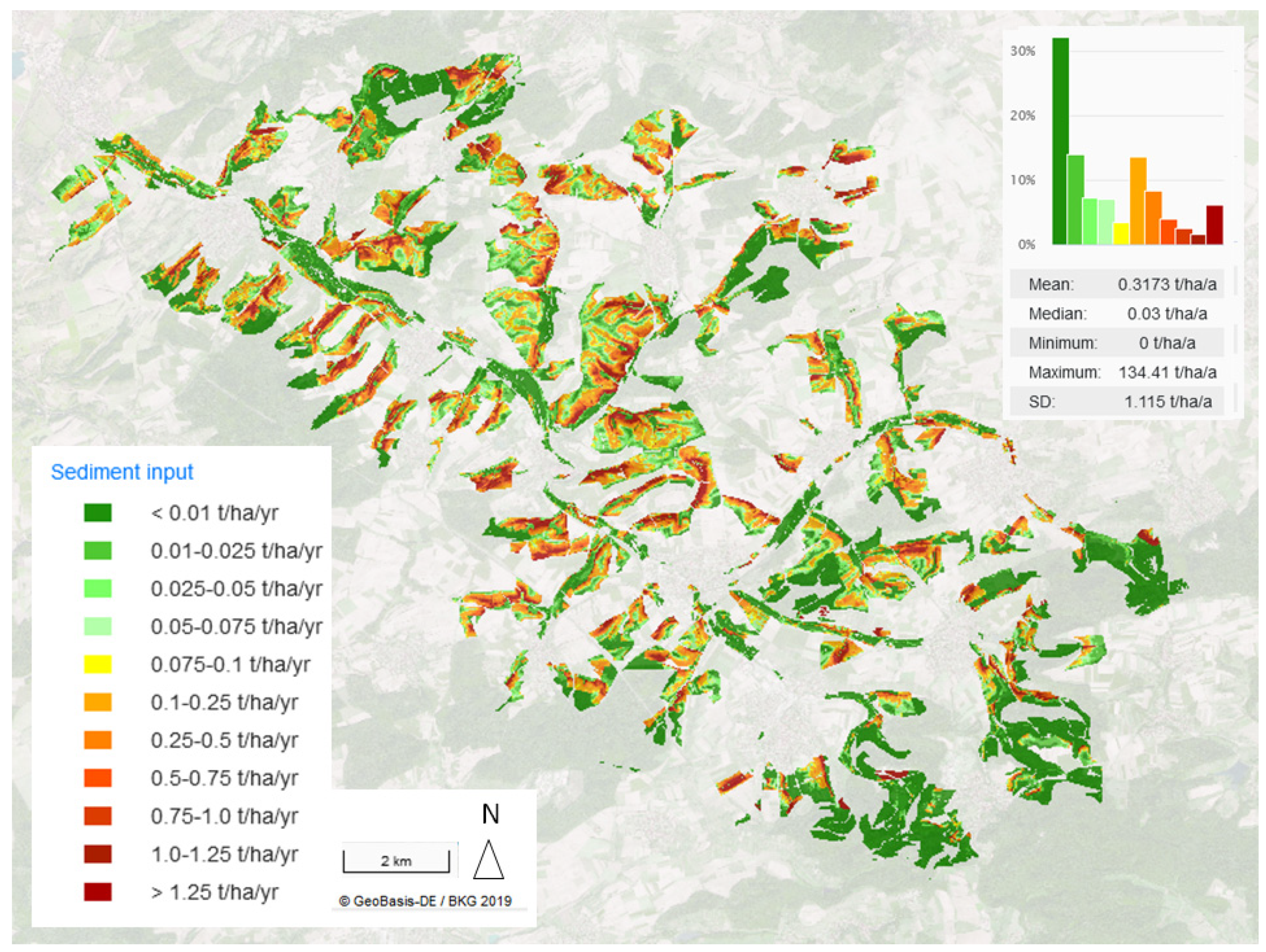
2.3. Modeling Approaches of the Sediment Input
- Area connection to the watercourse system;
- Watercourse distance;
- Connectivity probability;
- Sediment delivery ratio;
- Grid-related sediment input.
3. Results
3.1. River Concentrations
3.1.1. Concentrations during Dry Weather Flow
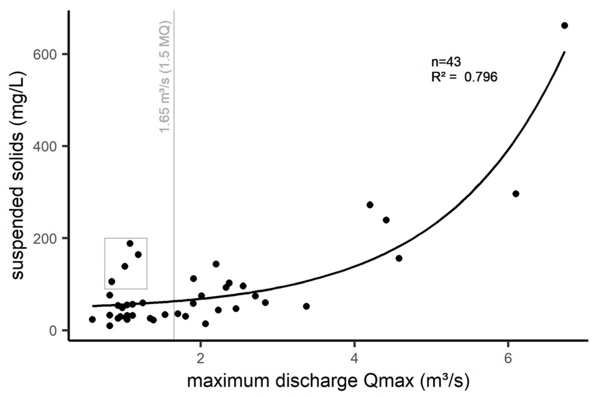
3.1.2. Concentrations during Erosion Events
3.2. Determined Sediment Loads for Long-Term Discharges Based on Monitoring
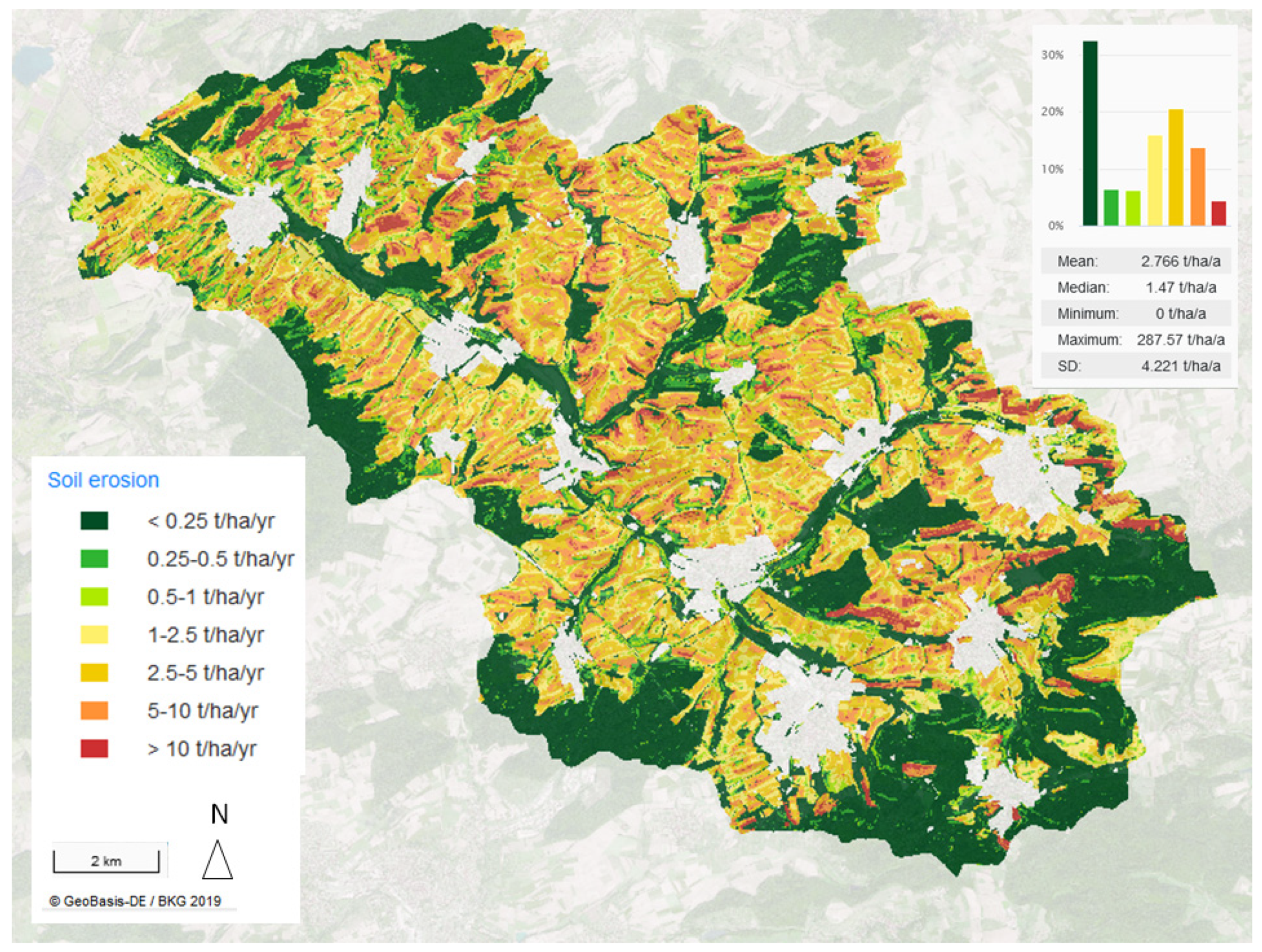
3.3. Results of the Modeling
4. Discussion
5. Conclusions
Author Contributions
Funding
Institutional Review Board Statement
Informed Consent Statement
Data Availability Statement
Acknowledgments
Conflicts of Interest
References
- Directive 2000/60/EC of the European Parliament and of the Council of 23 October 2000 Establishing a Framework for Community Action in the Field of Water Policy: WFD, 2000. Available online: https://eur-lex.europa.eu/legal-content/en/ALL/?uri=CELEX%3A32000L0060 (accessed on 17 December 2021).
- Bundesregierung Deutschland. Oberflächengewässerverordnung (Verordnung zum Schutz der Oberflächengewässer) vom 20. Juni 2016: OGewV, 2016. Available online: http://www.gesetze-im-internet.de/ogewv_2016/OGewV.pdf (accessed on 17 December 2021).
- Lemm, J.U.; Venohr, M.; Globevnik, L.; Stefanidis, K.; Panagopoulos, Y.; Gils, J.; Posthuma, L.; Kristensen, P.; Feld, C.K.; Mahnkopf, J.; et al. Multiple stressors determine river ecological status at the European scale: Towards an integrated understanding of river status deterioration. Glob. Chang. Biol. 2021, 27, 1962–1975. [Google Scholar] [CrossRef] [PubMed]
- European Commission. Report from the Commission to the Eurpean Parliament and the Council on the Implementation of the Water Framework Directive (2000/60/EC) and the Floods Directive (2007/60/EC). Available online: https://eur-lex.europa.eu/legal-content/EN/TXT/HTML/?uri=COM:2019:95:FIN&from=EN (accessed on 17 December 2021).
- Fuchs, S.; Weber, T.; Wander, R.; Toshovski, S.; Kittlaus, S.; Reid, L.; Bach, M.; Klement, L.; Hillenbrand, T.; Tettenborn, F. Effizienz von Maßnahmen zur Reduktion von Stoffeinträgen, 1st ed.; Endbericht; Umweltbundesamt: Dessau-Roßlau, Germany, 2017. [Google Scholar]
- Fuchs, S.; Rothvoß, S.; Toshovski, S. Ubiquitäre Schadstoff—Eintragsinventare, Umweltverhalten und Eintragsmodellierung: Abschlussbericht (Forschungskennzahl 3714 21 200 0). TEXTE 52/2018. 2018. Available online: https://www.umweltbundesamt.de/publikationen/ubiquitaere-schadstoffe-eintragsinventare (accessed on 17 December 2021).
- Abdelwahab, O.M.M.; Bisantino, T.; Milillo, F.; Gentile, F. Runoff and sediment yield modeling in a medium-size mediterranean watershed. J. Agric. Eng. 2013, 44. [Google Scholar] [CrossRef]
- Arnold, J.G.; Moriasi, D.N.; Gassman, P.W.; Abbaspour, K.C.; White, M.J.; Srinivasan, R.; Santhi, C.; Harmel, R.D.; van Griensven, A.; van Liew, M.W.; et al. SWAT: Model Use, Calibration, and Validation. Trans. ASABE 2012, 55, 1491–1508. [Google Scholar] [CrossRef]
- Ta, P.; Tetzlaff, B.; Trepel, M.; Wendland, F. Implementing a Statewide Deficit Analysis for Inland Surface Waters According to the Water Framework Directive—An Exemplary Application on Phosphorus Pollution in Schleswig-Holstein (Northern Germany). Water 2020, 12, 1365. [Google Scholar] [CrossRef]
- Fuchs, S.; Kaiser, M.; Kiemle, L.; Kittlaus, S.; Rothvoß, S.; Toshovski, S.; Wagner, A.; Wander, R.; Weber, T.; Ziegler, S. Modeling of Regionalized Emissions (MoRE) into Water Bodies: An Open-Source River Basin Management System. Water 2017, 9, 239. [Google Scholar] [CrossRef]
- Gebel, M.; Uhlig, M.; Halbfass, S.; Meissner, R.; Duan, S. Predicting erosion and sediment yield in a mesoscale basin in the semiarid monsoon region Miyun/China. Ecol. Process. 2014, 3, 39. [Google Scholar] [CrossRef] [Green Version]
- Gebel, M.; Bürger, S.; Wallace, M.; Malherbe, H.; Vogt, H.; Lorz, C. Simulation of land use impacts on sediment and nutrient transfer in coastal areas of Western Cape, South Africa. Chang. Adapt. Socio-Ecol. Syst. 2017, 3, 1–17. [Google Scholar] [CrossRef]
- Tetzlaff, B.; Wendland, F. Modelling Sediment Input to Surface Waters for German States with MEPhos: Methodology, Sensitivity and Uncertainty. Water Resour Manag. 2012, 26, 165–184. [Google Scholar] [CrossRef]
- Behrendt, H.; Huber, P.; Kornmilch, M.; Opitz, D.; Schmoll, O.; Scholz, G.; Uebe, R. Nutrient Emissions into River Basins, 1st ed.; Federal Environment Agency (Umweltbundesamt): Berlin, Germany, 2000. [Google Scholar]
- Venohr, M.; Hirt, U.; Hofmann, J.; Opitz, D.; Gericke, A.; Wetzig, A.; Natho, S.; Neumann, F.; Hürdler, J.; Matranga, M.; et al. Modelling of Nutrient Emissions in River Systems—MONERIS—Methods and Background. Int. Rev. Hydrobiol. 2011, 96, 435–483. [Google Scholar] [CrossRef]
- Borrelli, P.; van Oost, K.; Meusburger, K.; Alewell, C.; Lugato, E.; Panagos, P. A step towards a holistic assessment of soil degradation in Europe: Coupling on-site erosion with sediment transfer and carbon fluxes. Environ. Res. 2018, 161, 291–298. [Google Scholar] [CrossRef]
- Schmidt, B.; Kuhn, U.; Trepel, M.; Kreins, P.; Zinnbauer, M.; Eysholdt, M.; Osterburg, B.; Löw, P.; Wendland, F.; Herrmann, F.; et al. Modellansatz zur Bestimmung der Nährstoffbelastung und ihrer Reduktion in allen deutschen Flussgebieten. Wasser Und Abfall 2020, 22, 33–38. [Google Scholar] [CrossRef]
- Binger, R.L.; Theurer, F.D. AGNPS Web Site. Available online: http://www.ars.usda.gov/Research/docs.htm?docid=5199 (accessed on 25 October 2021).
- Hilden, M. Ermittlung von Stoff-Frachten in Fliessgewässern: Probenahmestrategien und Berechnungsverfahren; Kulturbuch-Verl.: Berlin, Germany, 2003; ISBN 3889612423. [Google Scholar]
- Horowitz, A.J. A review of selected inorganic surface water quality-monitoring practices: Are we really measuring what we think, and if so, are we doing it right? Environ. Sci. Technol. 2013, 47, 2471–2486. [Google Scholar] [CrossRef] [PubMed]
- Schreiber, W.; Krauss-Kalweit, I. Frachten von Wasserinhaltsstoffen in Fließgewässern—Einfluß der Probenahmestrategie auf die Ermittlung. Wasserwirtschaft 1999, 89, 520–645. [Google Scholar]
- Panagos, P.; Borrelli, P.; Poesen, J.; Ballabio, C.; Lugato, E.; Meusburger, K.; Montanarella, L.; Alewell, C. The new assessment of soil loss by water erosion in Europe. Environ. Sci. Policy 2015, 54, 438–447. [Google Scholar] [CrossRef]
- Wischmeyer, W.H.; Smith, D.D. Predicting Rainfall Erosion Losses. A Guide to Conservation Planning; The USDA Agricultural Handbook No. 537; The USDA: Annapolis, MD, USA, 1978.
- Wurbs, D.; Steininger, M. Wirkungen der Klimaänderungen auf die Böden: Untersuchungen zu den Auswirkungen des Klimawandels auf die Bodenerosion durch Wasser; Umweltbundesamt: Dessau-Roßlau, Germany, 2011. [Google Scholar]
- Bundesanstalt für Geowissenschaften und Rohstoffe. Potentielle Erosionsgefährdung der Ackerböden durch Wasser in Deutschland: Herausgegeben von der Bundesanstalt für Geowissenschaften. Available online: https://www.bgr.bund.de/DE/Themen/Boden/Ressourcenbewertung/Bodenerosion/Wasser/PEGWasser_Handzettel_de.pdf?__blob=publicationFile&v=1 (accessed on 25 October 2021).
- Plambeck, N.O. Reassessment of the potential risk of soil erosion by water on agricultural land in Germany: Setting the stage for site-appropriate decision-making in soil and water resources management. Ecol. Indic. 2020, 118, 106732. [Google Scholar] [CrossRef]
- Auerswald, K.; Fischer, F.K.; Winterrath, T.; Brandhuber, R. Rain erosivity map for Germany derived from contiguous radar rain data. Hydrol. Earth Syst. Sci. 2019, 23, 1819–1832. [Google Scholar] [CrossRef] [Green Version]
- Auerswald, K.; Ebertseder, F.; Levin, K.; Yuan, Y.; Prasuhn, V.; Plambeck, N.O.; Menzel, A.; Kainz, M. Summable C factors for contemporary soil use. Soil Tillage Res. 2021, 213, 105155. [Google Scholar] [CrossRef]
- Prasuhn, V. Twenty years of soil erosion on-farm measurement: Annual variation, spatial distribution and the impact of conservation programmes for soil loss rates in Switzerland. Earth Surf. Process. Landf. 2020, 45, 1539–1554. [Google Scholar] [CrossRef]
- Poesen, J. Soil erosion in the Anthropocene: Research needs. Earth Surf. Process. Landf. 2018, 43, 64–84. [Google Scholar] [CrossRef]
- Gebel, M.; Allion, K.; Plambeck, N.O.; Fuchs, S.; Ullrich, A. Deutschlandweite hochaufgelöste Modellierung von Sedimenttransfers in die Oberflächengewässer zur Ableitung partikelgebundener Phosphoreinträge. KW—Korrespondenz Wasserwirtschaft. 2021, 14, 413–417. [Google Scholar]
- Gebel, M.; Bürger, S.; Halbfass, S.; Uhlig, M. Modellgestützte Ermittlung der Nährstoffeinträge in sächsische Gewässer: Status quo und Ausblick bis 2027. Available online: https://publikationen.sachsen.de/bdb/artikel/11373 (accessed on 15 October 2021).
- Wagner, A. Event-Based Measurement and Mean Annual Flux Assessment of Suspended Sediment in Meso Sclae Catchments. Dissertation; Karlsruher Institut für Technologie: Karlsruhe, Germany, 2019. [Google Scholar]
- Allion, K.; Kiemle, L.; Fuchs, S. Four years of sediment and phosphorus monitoring in the Kraichbach river using large-volume samplers. Water 2021. submitted. [Google Scholar]
- Fuchs, S.; Mayer, I.; Haller, B.; Roth, H. Lamella settlers for storm water treatment—performance and design recommendations. Water Sci. Technol. 2014, 69, 278–285. [Google Scholar] [CrossRef] [PubMed]
- Kemper, M.; Eyckmanns-Wolters, R.; Fuchs, S.; Ebbert, S.; Maus, C.; Uhl, M.; Weiß, G.; Nichler, T.; Engelberg, M.; Gillar, M.; et al. Analyse der Leistungsfähigkeit von Regenüberlaufbecken und Überwachung durch Online Messtechnik; Abschlussbericht, 2015. Available online: http://www.lanuv.nrw.de/uploads/tx_mmkresearchprojects/2015_12_16_Schlussbericht_Monitoring.pdf (accessed on 26 January 2016).
- Nickel, J.P.; Fuchs, S. Micropollutant emissions from combined sewer overflows. Water Sci. Technol. 2019, 80, 2179–2190. [Google Scholar] [CrossRef]
- Nickel, J.P.; Fuchs, S. Large-Volume Samplers for Efficient Composite Sampling and Particle Characterization in Sewer Systems. Water 2021, 13, 2831. [Google Scholar] [CrossRef]
- Toshovski, S.; Kaiser, M.; Fuchs, S.; Sacher, F.; Thoma, A.; Kümmel, V.; Lambert, B. Prioritäre Stoffe in kommunalen Kläranlagen: Ein deutschlandweit harmonisiertes Vorgehen; TEXTE 173/2020, Dessau-Roßlau, 2020. Available online: https://www.umweltbundesamt.de/publikationen/prioritaere-stoffe-in-kommunalen-klaeranlagen (accessed on 8 December 2020).
- Fuchs, S.; Wander, R.; Rogozina, T.; Hilgert, S.; Scherer, U. Methodische Optimierung von Modellansätzen zur Schadstoffbilanzierung in Flussgebietseinheiten zur Förderung der Umsetzungsstrategie zur Wasserrahmenrichtlinie: Endbericht für das Vorhaben FZK: 370 822 202/01, Karlsruhe, 2012. Available online: http://digbib.ubka.uni-karlsruhe.de/volltexte/1000051892 (accessed on 17 December 2021).
- Fuchs, S.; Butz, J.; Bechtel, A. Stoffstromanalysen für kleine bis mittlere Flussgebiete als Grundlage für die Planung und Umsetzung von Gewässerschutzmaßnahmen: Forschungsbericht FZKA-BWPLUS, 2004. Available online: https://pudi.lubw.de/detailseite/-/publication/74744 (accessed on 17 December 2021).
- Schwertmann, U.; Vogl, W.; Kainz, M. Bodenerosion durch Wasser: Vorhersage des Abtrags und Bewertung von Gegenmaßnahmen, 2nd ed.; Ulmer: Stuttgart, Germany, 1990; ISBN 9783800130887. [Google Scholar]
- Schmidt, J. Entwicklung und Anwendung eines Physikalisch Begründeten Simulationsmodells für die Erosion Geneigter landwirtschaftlicher Nutzflächen; Selbstverl. des Inst. für Geograph. Wiss.: Berlin, Germany, 1996. [Google Scholar]
- Schob, A.; Schmidt, J.; Tenholtern, R. Derivation of site-related measures to minimise soil erosion on the watershed scale in the Saxonian loess belt using the model EROSION 3D. Catena 2006, 68, 153–160. [Google Scholar] [CrossRef]
- Kinnell, P.I.A. The USLE-M and Modeling Erosion within Catchments. In Sustaining the Global Farm. Selected papers from the 10th International Soil Conservation Organization on Meeting held May 24–29, 1999 at Perdue University and the USDA-ARS National Soil Erosion Research Laboratory; Stott, D.E., Mohtar, R.H., Steinhardt, G.C., Eds.; International Soil Conservation Organization (ISCO): West Lafayette, IN, USA, 2001; pp. 924–928. [Google Scholar]
- Auerswald, K.; Schwertmann, U. Modelle zur Erosionsvorhersage als Entscheidungsgrundlage des Bodenschutzes. Bodenschutz 1988, 30, 233–241. [Google Scholar]
- Fischer, F.K.; Winterrath, T.; Junghänel, T.; Walawender, E.; Auerswald, K. Mean Annual Precipitation Erosivity (R Factor) Based on RADKLIM. Version 2017.002. 2019. Available online: https://doi.org/10.5676/DWD/RADKLIM_Rfct_V2017.002 (accessed on 17 December 2021).
- Sauerborn, P. Die Erosivität der Niederschläge in Deutschland—Ein Beitrag zur quantitaiven Prognose der Bodenerosion durch Wasser in Mitteleuropa. Ph.D. Thesis, Leibniz University, Hannover, Germany, 1994. [Google Scholar]
- Bundesanstalt für Geowissenschaften und Rohstoffe. Bodenübersichtskarte der Bundesrepublik Deutschland 1:200.000 (BÜK200); Bundesanstalt für Geowissenschaften und Rohstoffe (BGR): Hannover, Germany, 2018. [Google Scholar]
- Renard, K.G.; Foster, G.R.; Weesies, G.A.; Mccool, D.K.; Yoder, D.C. Predicting Soil Erosion by Water: A guide to Conservation Planning with the Revised Universal Soil Loss Equation (RUSLE); Agriculture Handbook No. 703; The USDA: Annapolis, MD, USA, 1997.
- Moore, I.D.; Nieber, J.L. Landscape assessment of soil erosion and nonpoint source pollution. J. Minnesota Acad. Sci. 1989, 55, 18–25. [Google Scholar]
- Hrabalíková, M.; Janeček, M. Comparison of different approaches to LS factor calculations based on a measured soil loss under simulated rainfall. Soil Water Res. 2017, 12, 69–77. [Google Scholar] [CrossRef] [Green Version]
- Desmet, P.J.J.; Govers, G. A GIS procedure for automatically calculating the USLE LS factor on topographically complex landscape units. J. Soil Water Conserv. 1996, 51, 427–433. [Google Scholar]
- Destatis. Land-und Forstwirtschaft, Fischerei: Bodenbearbeitung, Erosionsschutz, Fruchtwechsel/Agrarstrukturerhebung. Available online: https://www.destatis.de/DE/Themen/Branchen-Unternehmen/Landwirtschaft-Forstwirtschaft-Fischerei/Produktionsmethoden/Publikationen/Downloads-Produktionsmethoden/bodenbearbeitung-erosionsschutz-fruchtwechsel-5411209169004.html (accessed on 17 December 2021).
- EUROSTAT. Statistics Explained: Agri-environmental Indicator—Tillage Practices. Available online: https://ec.europa.eu/eurostat/statistics-explained/index.php/Agri-environmental_indicator_-_tillage_practices#Analysis_at_regional_level (accessed on 15 October 2021).
- Panagos, P.; Borrelli, P.; Meusburger, K.; Alewell, C.; Lugato, E.; Montanarella, L. Estimating the soil erosion cover-management factor at the European scale. Land Use Policy 2015, 48, 38–50. [Google Scholar] [CrossRef]
- Wu, S.; Li, J.; Huang, G. An evaluation of grid size uncertainty in empirical soil loss modeling with digital elevation models. Env. Model Assess 2005, 10, 33–42. [Google Scholar] [CrossRef]
- Voges, J. Empirisches Modell für die mittlere Maßstabsebene zur GIS-Gestützten Bestimmung der Anbindung Erosionsgefährdeter Ackerflächen. Ph.D. Thesis, Hannover Universität, Hannover, Germany, 1999. [Google Scholar]
- Veith, T. Agricultural BMP Placement for Cost-Effective Pollution Control at the Watershed Level; Virginia Polytechnic Institute and State University: Black Fort, VA, USA, 2002. [Google Scholar]
- Halbfass, S. Entwicklung eines GIS-gestützten Modells zur Quantifizierung Diffuser Phosphoreinträge in Oberflächengewässer im Mittleren Maßstab unter Berücksichtigung Geoökologisch Wirksamer Raumstrukturen; Rhombos-Verl.: Berlin, Germany, 2005; ISBN 3937231765. [Google Scholar]
- Halbfass, S.; Grunewald, K. Abschätzung potenzieller Herkunftsflächen von erosionsbedingten Stoffeinträgen in Oberflächengewässer im mittleren Maßstab. Wasserwirtschaft 2006, 96, 24–28. [Google Scholar] [CrossRef]
- Halbfass, S.; Grunewald, K. Ermittlung räumlich verteilter SDR-Faktoren zur Modellierung von Sedimenteinträgen in Fließgewässer im mittleren Maßstab. Wasserwirtschaft 2008, 3, 31–35. [Google Scholar]
- Mitigation Options for Nutrient Reduction in Surface Water and Groundwaters: Proposal for a New COST Action, COST Action 869. In Proceedings of the 164th CSO Meeting, Brussels, Belgium, 29–30 March 2006.
- Bundesamt für Kartographie und Geodäsie. Digitales Geländemodell für Deutschland im 10-m-Raster; DGM10/BKG/2017; Bundesamt für Kartographie und Geodäsie: Frankfurt am Main, Germany, 2017. [Google Scholar]
- Bundesamt für Kartographie und Geodäsie. Digitales Basis-Landschaftsmodell 2016 (AAA-Modellierung). Bundesrepublik Deutschland: UTM-Abbildung in der Zone 32 und 33; Bundesamt für Kartographie und Geodäsie: Frankfurt am Main, Germany, 2019. [Google Scholar]
- Ali, K.F.; De Boer, D.H. Spatially distributed erosion and sediment yield modeling in the upper Indus River basin. Water Resour. Res. 2010, 46, 1–16. [Google Scholar] [CrossRef]
- Freeman, T.G. Calculating catchment area with divergent flow based on a regular grid. Comput. Geosci. 1991, 17, 413–422. [Google Scholar] [CrossRef]
- O’Callaghan, J.F.; Mark, D.M. The extraction of drainage networks from digital elevation data. Comput. Vis. Graph. Image Process. 1984, 28, 323–344. [Google Scholar] [CrossRef]
- Nobre, A.D.; Cuartas, L.A.; Hodnett, M.; Rennó, C.D.; Rodrigues, G.; Silveira, A.; Waterloo, M.; Saleska, S. Height Above the Nearest Drainage—A hydrologically relevant new terrain model. J. Hydrol. 2011, 404, 13–29. [Google Scholar] [CrossRef] [Green Version]
- Nickel, J.P.; Fuchs, S.; Hörner, L. Aktuelle Daten zur stofflichen Belastung von Mischwasserentlastungen. Korrepondonz Abwasser Abfall (KA) 2021, 68, 1–7. [Google Scholar]
- Kiemle, L.; Wagner, A.; Hüsener, J.; Fuchs, S.; Henning, K.; Haile, C. Modellierung der Nährstoffeinträge in die Fließgewässer Baden-Württembergs für die Aktualisierung der Bewirtschaftungspläne nach WRRL: Modellbeschreibung und Ergebnisse der MONERIS-BW Version “August 2019”; unpublished; Karlsruhe, Germany, 2019. [Google Scholar]
- Horowitz, A.J. Determining annual suspended sediment and sediment-associated trace element and nutrient fluxes. Sci. Total. Environ. 2008, 400, 315–343. [Google Scholar] [CrossRef]
- Fischer, F.K.; Auerswald, K.; Winterrath, T.; Brandhuber, R. Klimabedingte Zunahme der Regenerosivität seit 1960. Korresp. Wasserwirtsch. 2020, 13, 609–613. [Google Scholar]
- Brandhuber, R.; Treisch, M.; Fischer, F.; Kistler, M.; Maier, H.; Auerswald, K. Starkregen, Bodenabschwemmungen und Struzfluten: Beobachtungen und Analysen im Mai/Juni 2016; Bayerische Landesanstalt für Landwirtschaft (LfL), Freising-Weihenstephan: Munich, Germany, 2016. [Google Scholar]
- Carter, J.; Owens, P.N.; Walling, D.E.; Leeks, G.J.L. Fingerprinting suspended sediment sources in a large urban river system. Sci. Total Environ. 2003, 314–316, 513–534. [Google Scholar] [CrossRef]
- Auerswald, K.; Wiegand, S. Ist die Erosionsschadenskartierung geeignet, um im Sinne der Bundes-Bodenschutz- und Altlastenverordnung Erosionsflächen zu identifizieren und den Bodenabtrag festzustellen? Bodenschutz 2001, 4, 123–128. [Google Scholar]
- Bug, J.; Mosimann, T. Rill erosion in Lower Saxony—Results of an 11-year survey on the expansion, small-scale distribution and cause of soil erosion. Die Bodenkult. 2012, 63, 63–75. [Google Scholar]
- Mosimann, T.; Bug, J.; Sanders, S.; Beisiegel, F. Bodenerosionsdauerbeobachtung in Niedersachsen 2000–2008: Methodik, Erosionsgeschehen, Bodenabträge und Anwendung der Ergebnisse; Inst. für Physische Geographie und Landschaftsökologie Leibniz-Univ. Hannover: Hannover, Germany, 2009; ISBN 9783927053472. [Google Scholar]
- Auerswald, K.; Fiener, P.; Dikau, R. Rates of sheet and rill erosion in Germany—A meta-analysis. Geomorphology 2009, 111, 182–193. [Google Scholar] [CrossRef]
- Young, R.A.; Onstad, C.A.; Bosch, D.D.; Anderson, W.P. AGNPS: A nonpoint-source pollution model for evaluating agricultural watersheds. Kournal Soil Water Conserv. 1989, 44, 168–173. [Google Scholar]


| Property | Large-Volume Sampler |
|---|---|
| Sampling period | March 2017–June 2021 |
| Number of sampling periods | 43 |
| Sampling strategy | Volume-proportional, long-term |
| Sampling interval | 13,300 m3 |
| Subsample volume | 10–15 L |
| Tank volume | Stainless steel, 1000 L |
| Samples per container | 100 |
| Pumping system | Peristaltic |
| Pump capacity | 15,000 L∙h−1 |
| Parameter | Suspended Solid Concentration in mg L−1 |
|---|---|
| 25th percentile | 25.8 |
| Median | 31.9 |
| 75th percentile | 51.1 |
| Parameter | Dry-Weather Load Variant | ||
|---|---|---|---|
| Minimum | Mean | Maximum | |
| Mean annual load in t a−1 | 2826 | 2826 | 2826 |
| Mean dry-weather load in t a−1 | 467 | 577 | 925 |
| Mean precipitation input in t a−1, total | 2359 | 2249 | 1901 |
| Thereof combined sewer overflow | 49 | 49 | 49 |
| Thereof erosion | 2310 | 2200 | 1852 |
| Factor | Arable Land | Grass-Land | Fruit Growing | Viticulture | Coniferous Forest | Deciduous Forest | Mixed Forest | Nature Land |
|---|---|---|---|---|---|---|---|---|
| R-factor | 88.3 | 87.5 | 90.1 | 86.6 | 86.7 | 87.9 | 86.8 | 88.1 |
| K-factor | 0.47 | 0.43 | 0.29 | 0.28 | 0.53 | 0.49 | 0.47 | 0.50 |
| LS-factor | 1.16 | 1.59 | 0.97 | 2.16 | 1.76 | 1.95 | 2.14 | 1.73 |
| C-factor | 0.085 | 0.004 | 0.19 | 0.22 | 0.002 | 0.002 | 0.002 | 0.004 |
| Sediment Input in t ha−1 | Arable Land | Grass-Land | Fruit Growing | Viticulture | Coniferous Forest | Deciduous Forest | Mixed Forest | Nature Land |
|---|---|---|---|---|---|---|---|---|
| Mean | 0.478 | 0.009 | 0.638 | 2.08 | 0.003 | 0.004 | 0.003 | 0.017 |
| SD | 1.19 | 0.035 | 1.11 | 4.56 | 0.023 | 0.023 | 0.022 | 0.036 |
| Min | 0.000 | 0.000 | 0.000 | 0.000 | 0.000 | 0.000 | 0.000 | 0.000 |
| Max | 82.9 | 3.69 | 6.96 | 134 | 0.57 | 0.98 | 1.29 | 0.80 |
| Sum in t a−1 | Arable Land | Grass-Land | Fruit Growing | Viticulture | Coniferous Forest | Deciduous Forest | Mixed Forest | Nature Land | Total |
|---|---|---|---|---|---|---|---|---|---|
| Soil loss | 32,192 | 457.7 | 297.7 | 6286 | 16.3 | 228.1 | 217.3 | 157.4 | 39,853 |
| Sediment input | 1460 | 7.2 | 5.3 | 158.5 | 0.2 | 2.1 | 1.2 | 3.3 | 1638 |
Publisher’s Note: MDPI stays neutral with regard to jurisdictional claims in published maps and institutional affiliations. |
© 2021 by the authors. Licensee MDPI, Basel, Switzerland. This article is an open access article distributed under the terms and conditions of the Creative Commons Attribution (CC BY) license (https://creativecommons.org/licenses/by/4.0/).
Share and Cite
Allion, K.; Gebel, M.; Uhlig, M.; Halbfass, S.; Bürger, S.; Kiemle, L.; Fuchs, S. Use of Monitoring Approaches to Verify the Predictive Accuracy of the Modeling of Particle-Bound Solid Inputs to Surface Waters. Water 2021, 13, 3649. https://doi.org/10.3390/w13243649
Allion K, Gebel M, Uhlig M, Halbfass S, Bürger S, Kiemle L, Fuchs S. Use of Monitoring Approaches to Verify the Predictive Accuracy of the Modeling of Particle-Bound Solid Inputs to Surface Waters. Water. 2021; 13(24):3649. https://doi.org/10.3390/w13243649
Chicago/Turabian StyleAllion, Katharina, Michael Gebel, Mario Uhlig, Stefan Halbfass, Stephan Bürger, Lisa Kiemle, and Stephan Fuchs. 2021. "Use of Monitoring Approaches to Verify the Predictive Accuracy of the Modeling of Particle-Bound Solid Inputs to Surface Waters" Water 13, no. 24: 3649. https://doi.org/10.3390/w13243649
APA StyleAllion, K., Gebel, M., Uhlig, M., Halbfass, S., Bürger, S., Kiemle, L., & Fuchs, S. (2021). Use of Monitoring Approaches to Verify the Predictive Accuracy of the Modeling of Particle-Bound Solid Inputs to Surface Waters. Water, 13(24), 3649. https://doi.org/10.3390/w13243649