Evaluation and Optimization of Low Impact Development Designs for Sustainable Stormwater Management in a Changing Climate
Abstract
:1. Introduction
2. Materials and Methods
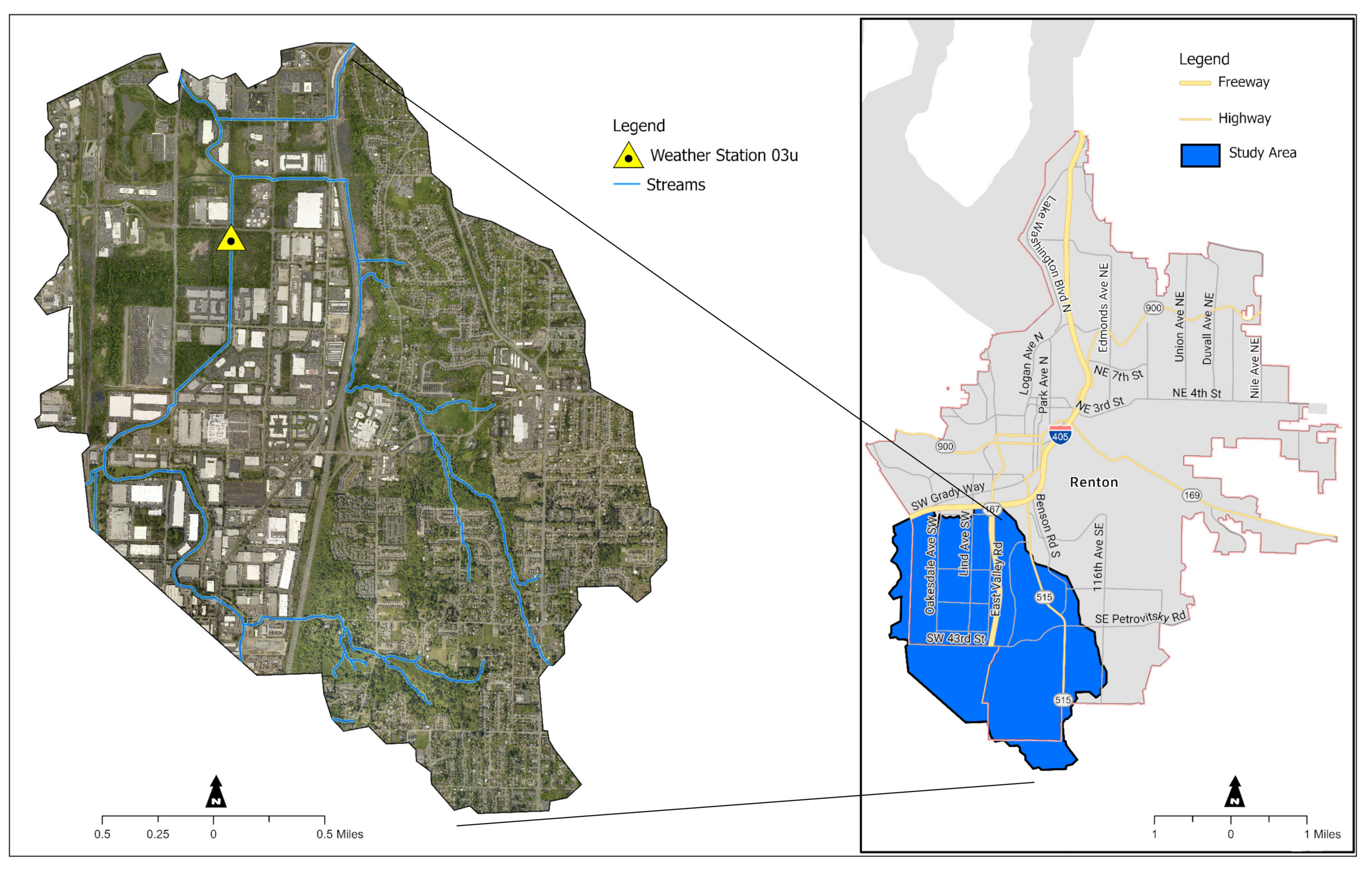
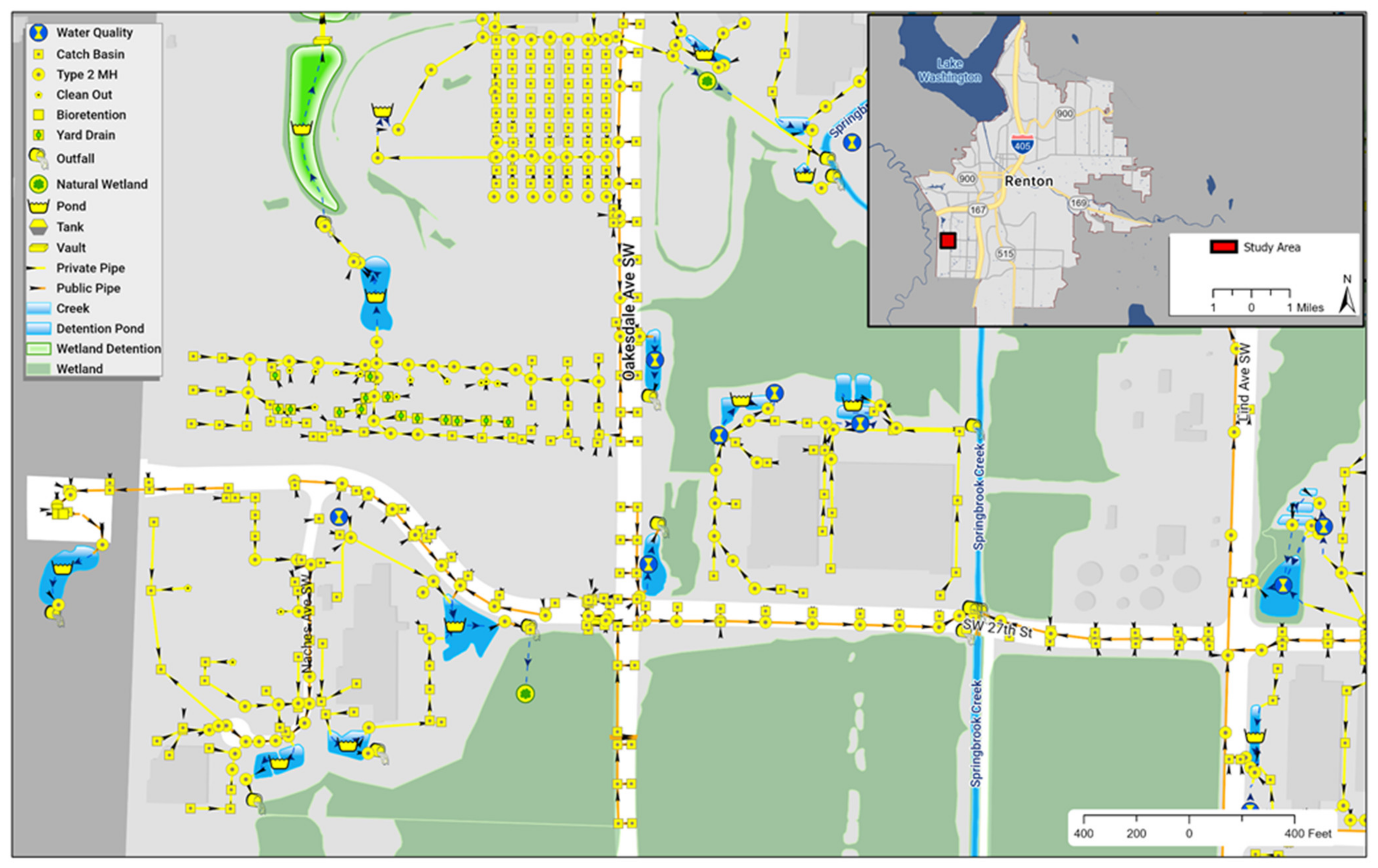
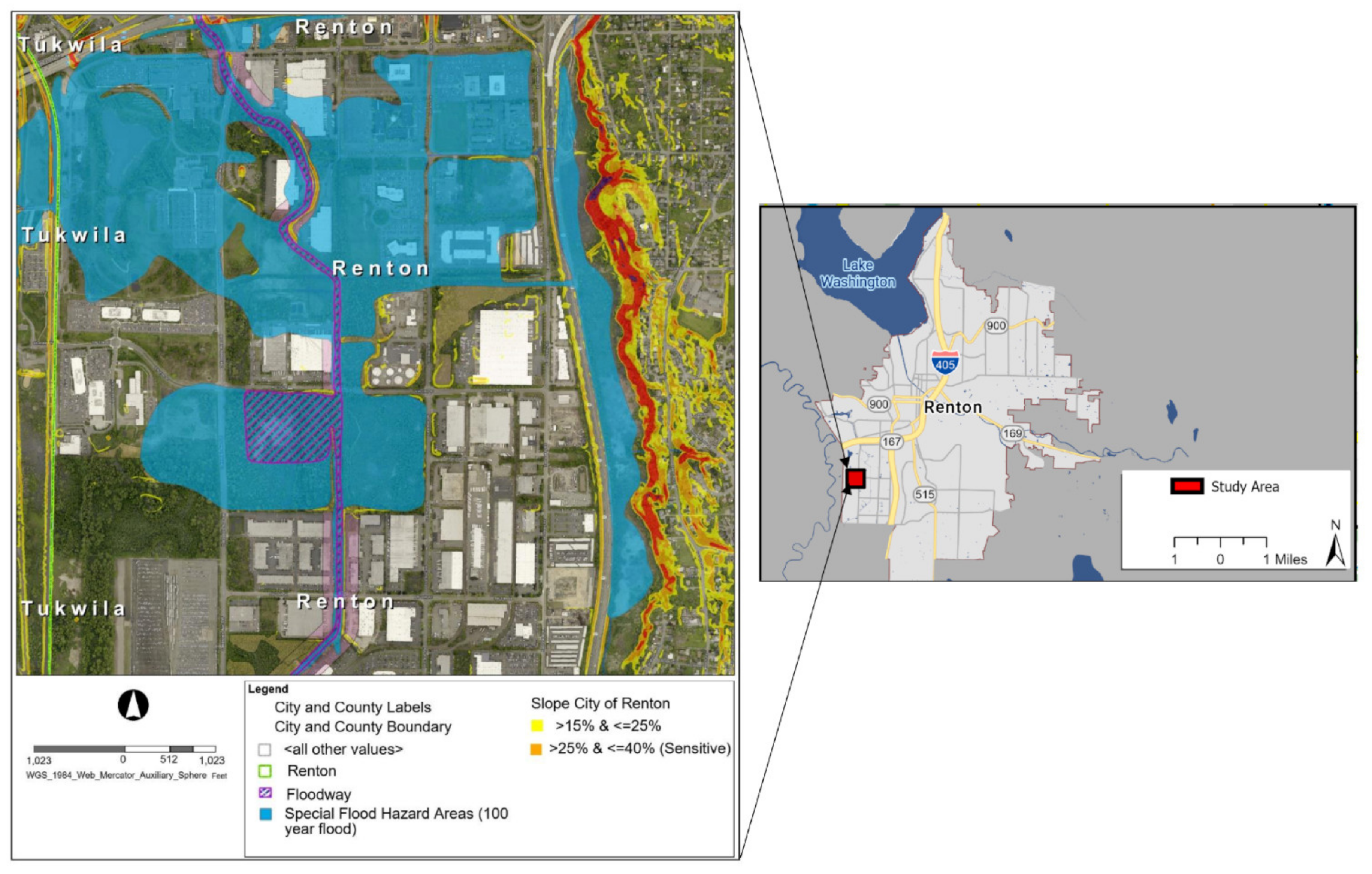
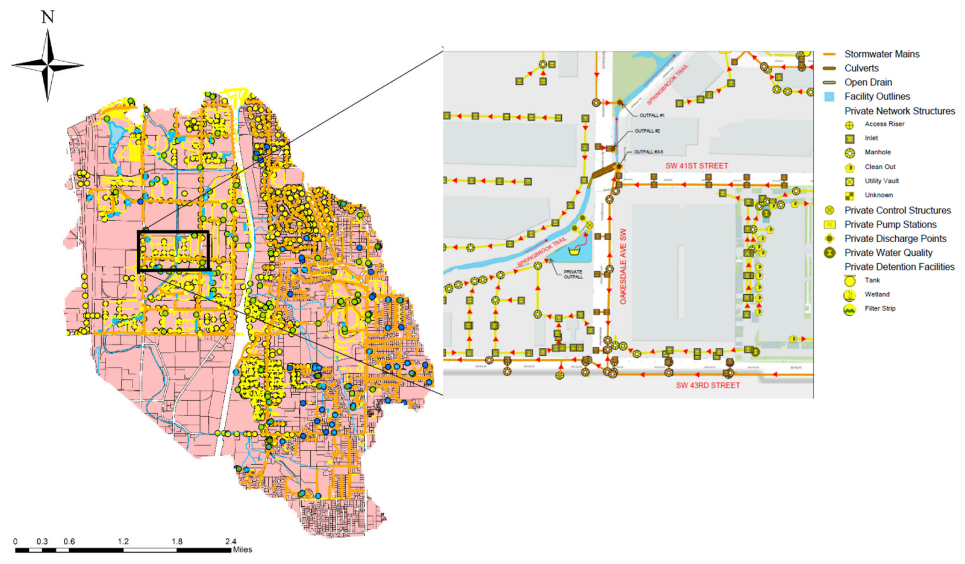
2.1. Study Area and Data
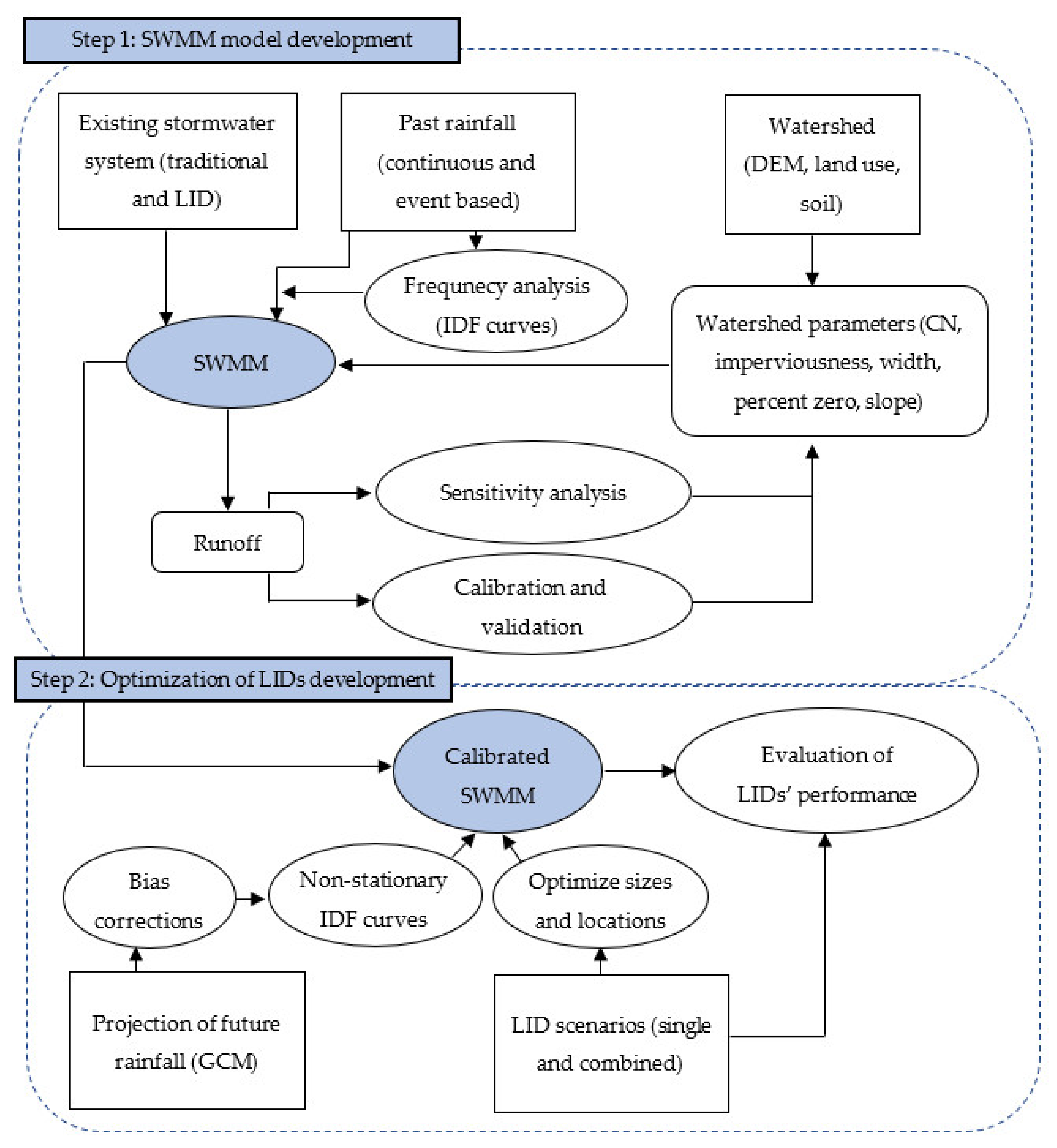
2.2. Methodologies
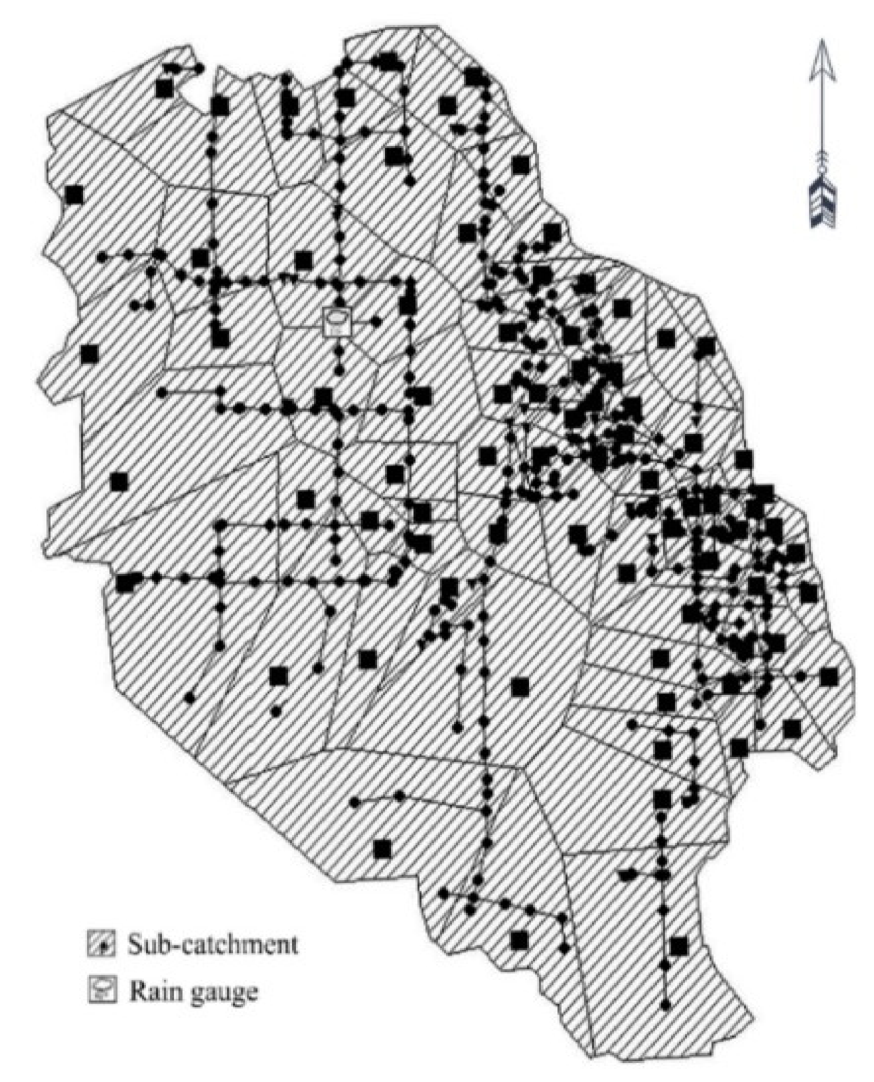
2.2.1. SWMM-Model Development
2.2.2. Sensitivity Analysis
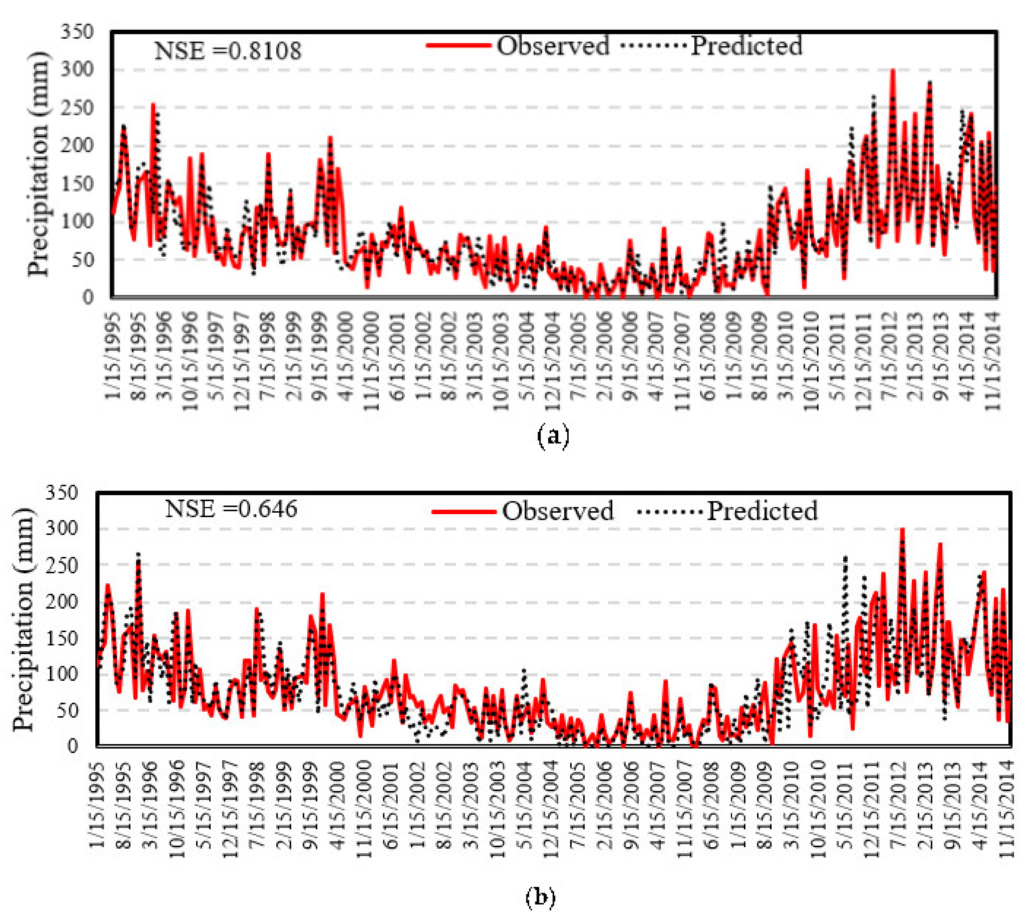
2.2.3. Downscaling of Precipitation
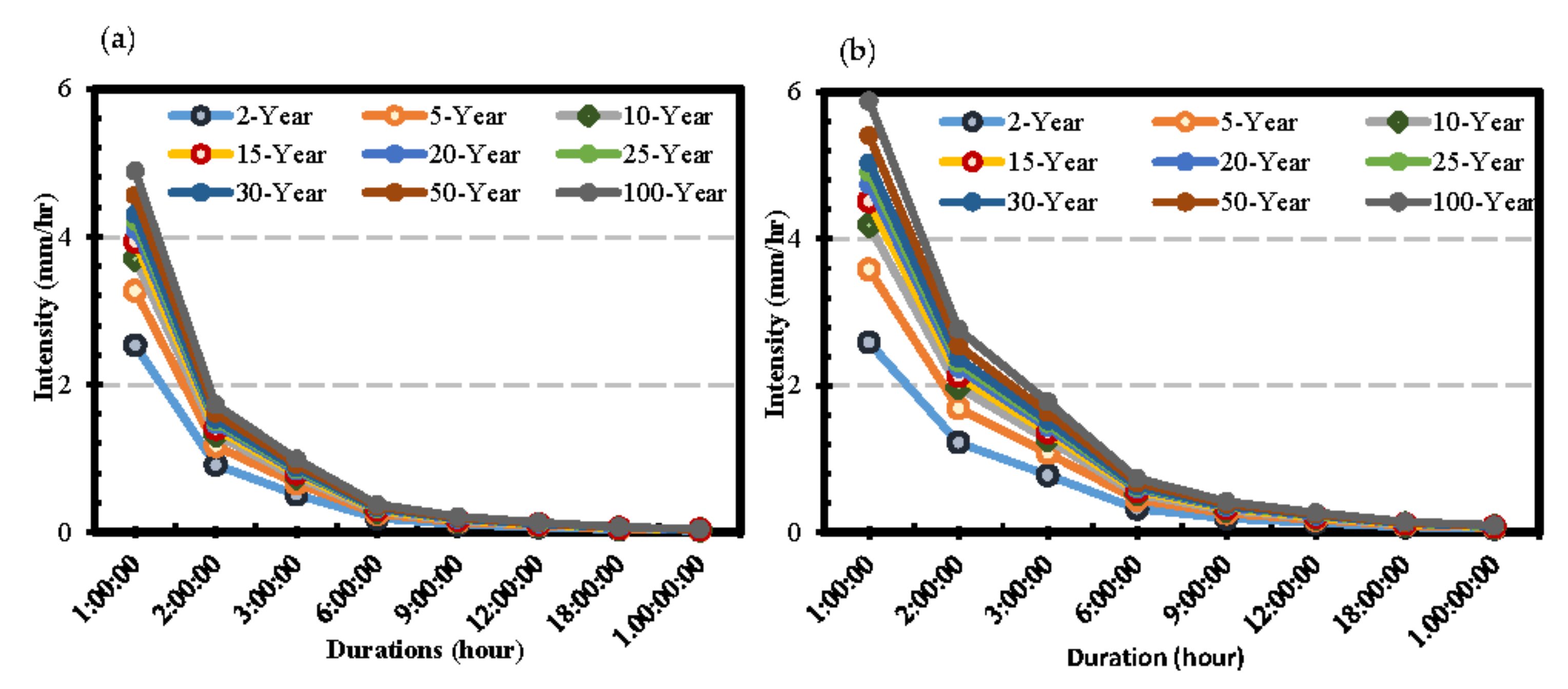
2.2.4. Development of Precipitation IDF Curves
2.2.5. LID Scenarios
3. Results and Discussions
3.1. Rainfall-Runoff Modeling
3.2. Sensitivity Analysis
3.3. Calibration and Validation of SWMM
3.4. Effects of Existing LIDs on Runoff
3.5. Effects of Proposed LIDs on Runoff
4. Conclusions
- (a)
- Statistical comparison of observed and downscaled precipitation data derived from the MIROC6 and CMCC-ESM2 confirmed that the MIROC6 is a better climate model to reproduce the observed precipitation in the study area. Precipitation is expected to increase under the highest emission scenario, which further aggravates the problem of stormwater management in the study area. The precipitation intensity for the 100 year return period will increase by 2.5% to 30% in 2020–2050 under the SSP585 compared to the historical observations.
- (b)
- Sensitivity analysis revealed that the percent imperviousness is the most sensitive parameter in the SWMM hydrological model for the study area. High variations in curve number magnitudes also have a relatively higher impact on the runoff. Percent changes in the width parameter cause an increase in overland flow length and overland flow travel time.
- (c)
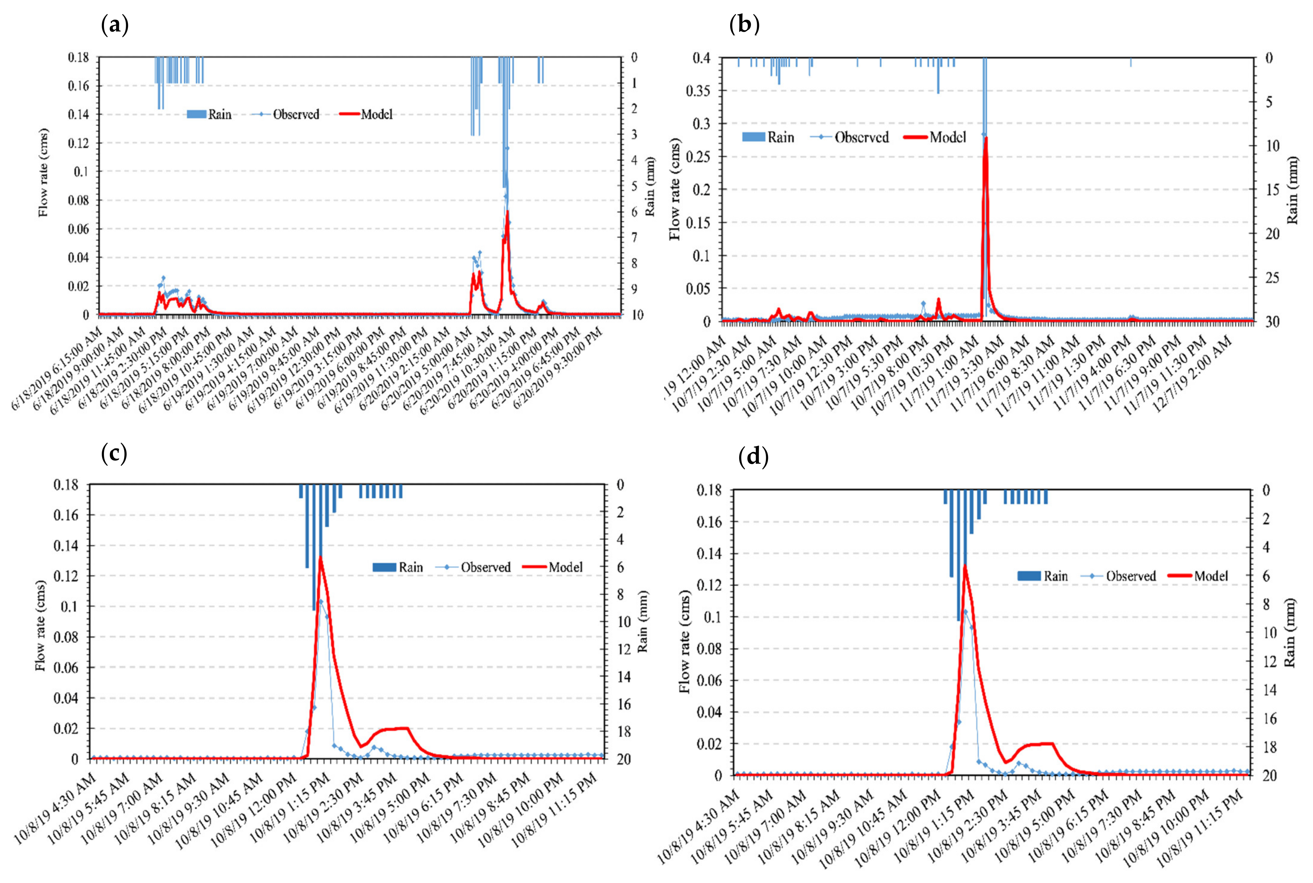
- Higher values of NSE (>0.8) and R2 (>0.79) for the calibration and validation periods confirm that the SWMM model captured the rainfall-runoff relationships across the watershed well.The model has the ability to simulate stormwater and runoff by considering the traditional and LID stormwater system under past and future storm conditions.
- (d)
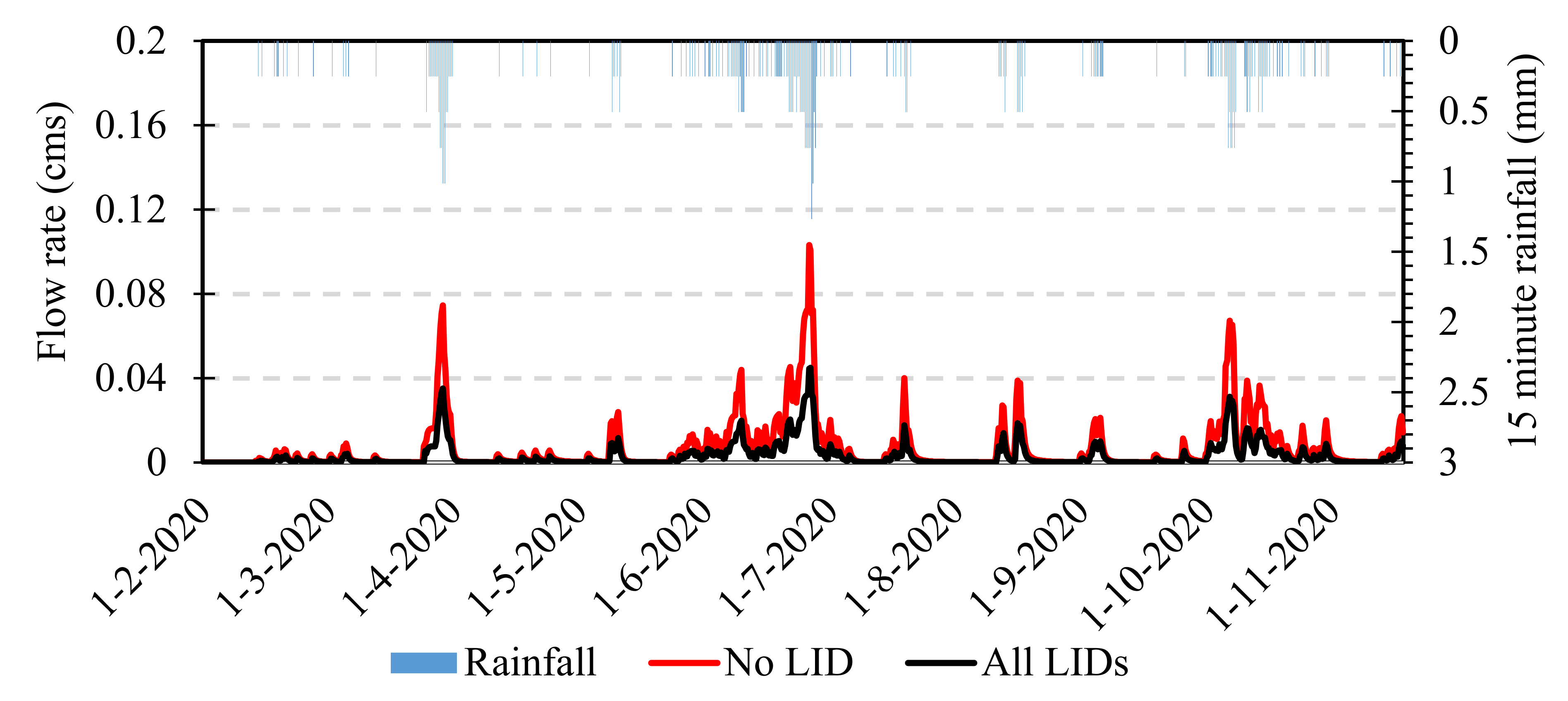
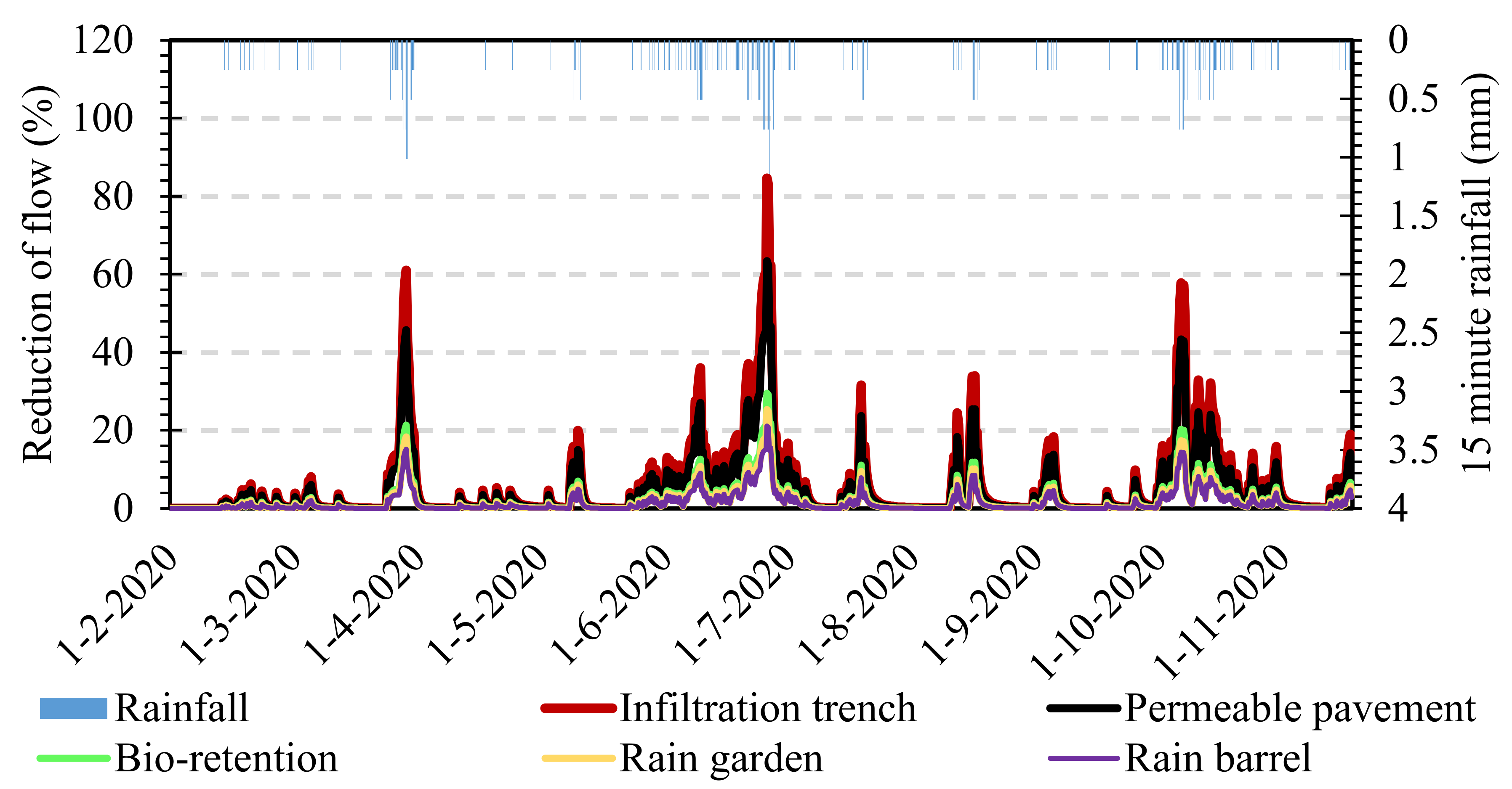
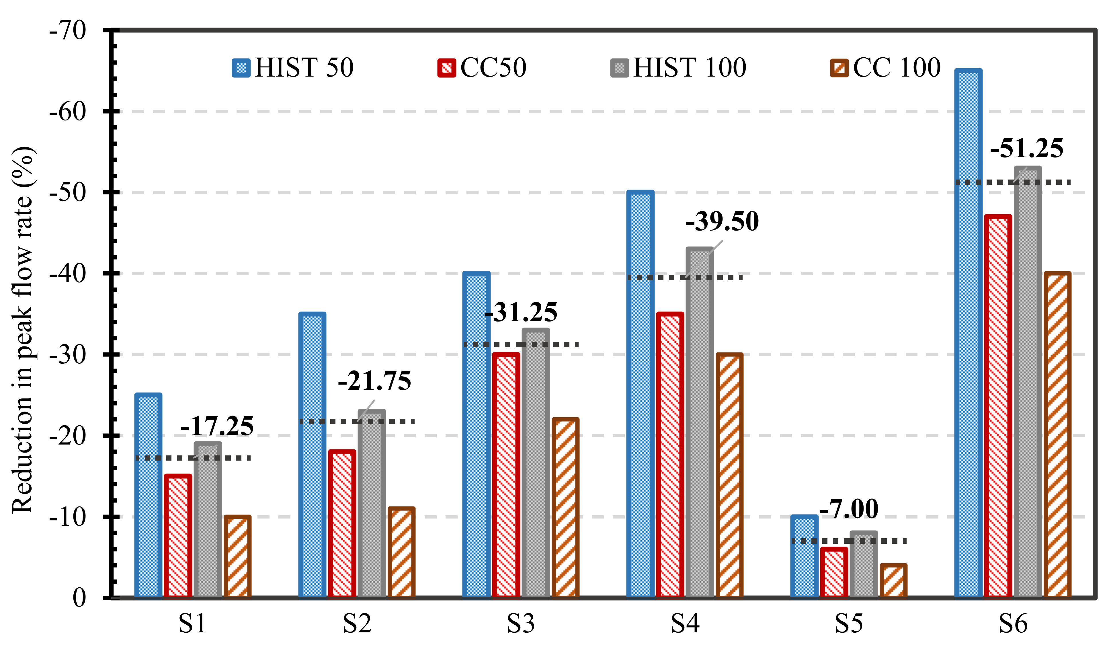
- Incorporating LIDs into the traditional stormwater system helps to reduce the stormwater and runoff. Compared to other commonly used LIDs, incorporating the infiltration trench was found to be more efficient in controlling the peak flows, while the rain barrel provided the lowest reduction in peak flows.
- (e)
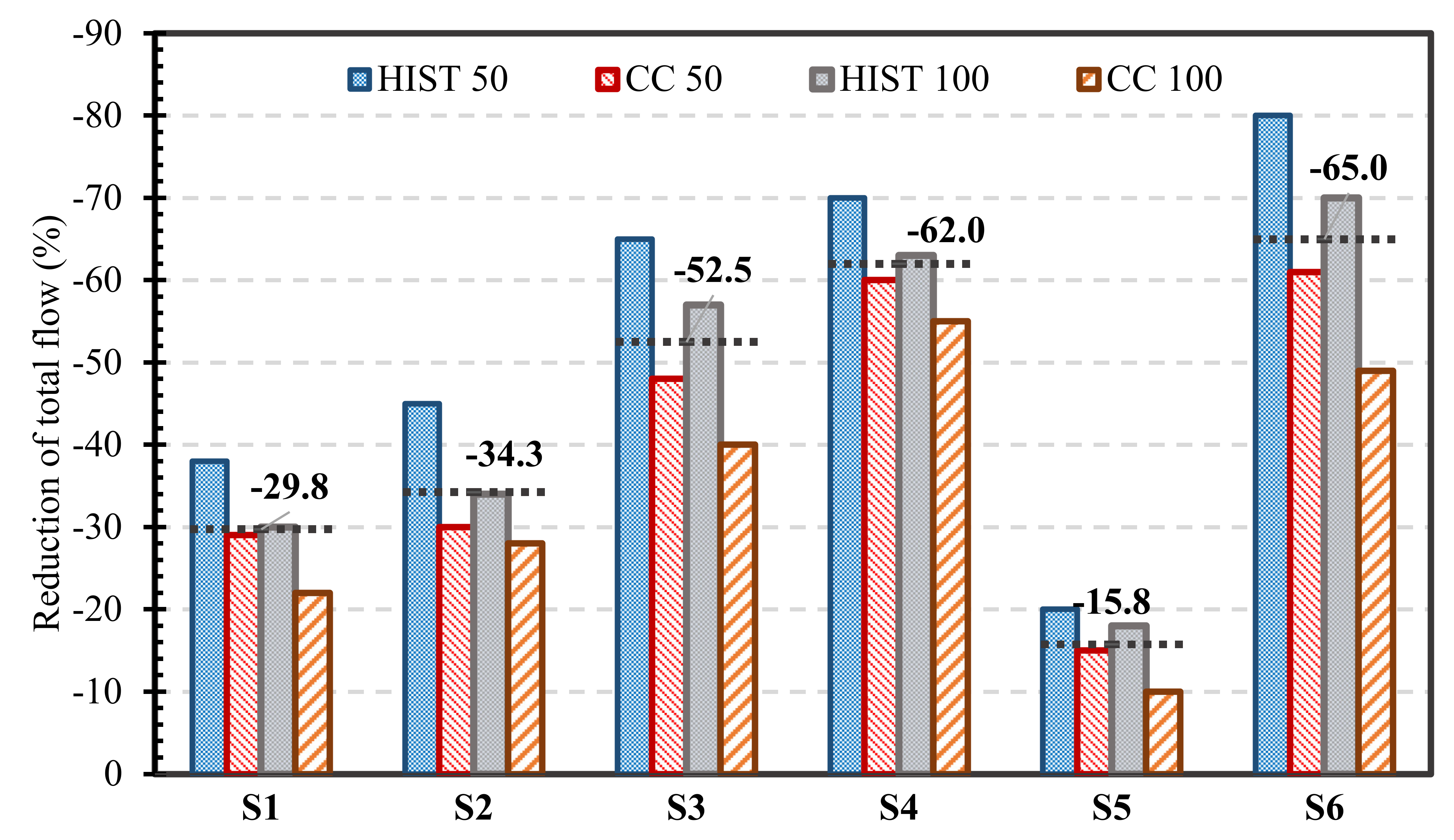
- In order to minimize the increasing flood risk in the study area, six LID scenarios were considered to extend the existing stormwater system, which consists of both conventional and LID stormwater. The combined implementation of the rain barrel collecting the rooftop runoff, bio-retention, and infiltration trench provides the most effective control to stormwater and runoff from the study area under both past and future storm conditions. The added LIDs are relatively more effective in reducing the flow volume than the peak flow. It was also found that the volume and peak flow reduction by the selected LID scenarios are relatively lower for the future storms compared to the historical ones because of the higher precipitation intensity in the future. A full optimization of the LIDs implementation is needed to further improve their performance. The optimization should include several other practically feasible LIDs, the size, and locations of the LIDs.
Author Contributions
Funding
Institutional Review Board Statement
Informed Consent Statement
Data Availability Statement
Acknowledgments
Conflicts of Interest
Abbreviations
| Abbreviation | Meaning |
| LID | Low Impact Development |
| SWMM | Storm Water Management Model |
| CMIP6 | Coupled Model Intercomparison Project Phase 6 |
| RCP | Representative Concentration Pathways |
| SSP | Shared Socio-economic Pathway |
| GCMs | global climate models |
| MIROC | Model for Interdisciplinary Research on Climate |
| CMCC-ESM | Euro-Mediterranean Centre on Climate Change coupled climate model-Earth System Model |
| SSURGO | Soil Survey Geographical Database |
| USDA | United States Department of Agriculture |
| HIST | Historical |
| CC | Climate Change (future) |
| FEMA | Federal Emergency Management Agency |
| NSE | Nash-Sutcliffe efficiency |
| IDF | Intensity-Duration-Frequency |
| SCS-CN | Soil Conservation Service-Curve Number |
| CN | Curve Number |
| DEM | Digital Elevation Model |
| NRCS | Natural Resources Conservation Service |
| IT | Infiltration Trench |
| RB | Rain Barrel |
| RG | Rain Garden |
| BR | Bioretention |
| PP | Permeable Pavement |
References
- Rhea, L.; Jarnagin, T.; Hogan, D.; Loperfido, J.V.; Shuster, W. Effects of urbanization and stormwater control measures on streamflows in the vicinity of Clarksburg, Maryland, USA. Hydrol. Process. 2015, 29, 4413–4426. [Google Scholar] [CrossRef]
- Su, Q.; Chang, H.-S. Exploring the Spatial Development of Watersheds and the Allocation of Responsibility for Stormwater Runoff from the Perspective of Ecological Efficiency Based on the DEA Method. Nat. Hazards Rev. 2021, 22, 4021041. [Google Scholar] [CrossRef]
- Dietz, M.E.; Clausen, J.C. Stormwater runoff and export changes with development in a traditional and low impact subdivision. J. Environ. Manag. 2008, 87, 560–566. [Google Scholar] [CrossRef] [PubMed]
- Jacobson, C.R. Identification and quantification of the hydrological impacts of imperviousness in urban catchments: A review. J. Environ. Manag. 2011, 92, 1438–1448. [Google Scholar] [CrossRef]
- Rezaei, A.R.; Ismail, Z.B.; Niksokhan, M.H.; Ramli, A.H.; Sidek, L.M.; Dayarian, M.A. Investigating the effective factors influencing surface runoff generation in urban catchments—A review. Desalinat. Water Treat. 2019, 164, 276–292. [Google Scholar] [CrossRef]
- Konrad, C.P. Effects of Urban Development on Floods; United States Geological Survey Fact Sheet 076–03; United States Geological Survey: Tacoma, WA, USA, 2003. [Google Scholar]
- Sheng, J.; Wilson, J.P. Watershed urbanization and changing flood behavior across the Los Angeles metropolitan region. Nat. Hazards 2009, 48, 41–57. [Google Scholar] [CrossRef]
- Douglas, E.M.; Fairbank, C.A. Is Precipitation in Northern New England Becoming More Extreme? Statistical Analysis of Extreme Rainfall in Massachusetts, New Hampshire, and Maine and Updated Estimates of the 100-Year Storm. J. Hydrol. Eng. 2011, 16, 203–217. [Google Scholar] [CrossRef] [Green Version]
- Papalexiou, S.M.; Montanari, A. Global and regional increase of precipitation extremes under global warming. Water Resour. Res. 2019, 55, 4901–4914. [Google Scholar] [CrossRef]
- Janssen, E.; Wuebbles, D.J.; Kunkel, K.E.; Olsen, S.C.; Goodman, A. Observational- and model-based trends and projections of extreme precipitation over the contiguous United States. Earth’s Futur. 2014, 2, 99–113. [Google Scholar] [CrossRef]
- Jung, M.; Kim, H.; Mallari, K.J.B.; Pak, G.; Yoon, J. Analysis of effects of climate change on runoff in an urban drainage system: A case study from Seoul, Korea. Water Sci. Technol. 2015, 71, 653–660. [Google Scholar] [CrossRef]
- Min, S.-K.; Zhang, X.; Zwiers, F.W.; Hegerl, G.C. Human contribution to more-intense precipitation extremes. Nature 2011, 470, 378–381. [Google Scholar] [CrossRef]
- Rosenberg, S.; Vedlitz, A.; Cowman, D.F.; Zahran, S. Climate change: A profile of US climate scientists’ perspectives. Clim. Chang. 2009, 101, 311–329. [Google Scholar] [CrossRef]
- Booth, D.B.; Hartley, D.; Jackson, R. Forest cover, impervious-surface area, and the mitigation of stormwater impacts. JAWRA J. Am. Water Resour. Assoc. 2002, 38, 835–845. [Google Scholar] [CrossRef]
- Gebreegziabher, M.; Demissie, Y. Modeling Urban Flood Inundation and Recession Impacted by Manholes. Water 2020, 12, 1160. [Google Scholar] [CrossRef] [Green Version]
- Moglen, G.E.; Vidal, G.E.R. Climate Change and Storm Water Infrastructure in the Mid-Atlantic Region: Design Mismatch Coming? J. Hydrol. Eng. 2014, 19, 4014026. [Google Scholar] [CrossRef]
- Moore, T.L.; Gulliver, J.S.; Stack, L.; Simpson, M.H. Stormwater management and climate change: Vulnerability and capacity for adaptation in urban and suburban contexts. Clim. Chang. 2016, 138, 491–504. [Google Scholar] [CrossRef]
- Burns, M.J.; Fletcher, T.D.; Walsh, C.J.; Ladson, A.R.; Hatt, B.E. Hydrologic shortcomings of conventional urban stormwater management and opportunities for reform. Landsc. Urban Plan. 2012, 105, 230–240. [Google Scholar] [CrossRef]
- Ahiablame, L.M.; Engel, B.A.; Chaubey, I. Effectiveness of Low Impact Development Practices: Literature Review and Suggestions for Future Research. Water Air Soil Pollut. 2012, 223, 4253–4273. [Google Scholar] [CrossRef]
- Eckart, K.; McPhee, Z.; Bolisetti, T. Performance and implementation of low impact development—A review. Sci. Total. Environ. 2017, 607–608, 413–432. [Google Scholar] [CrossRef]
- Rose, S.; Peters, N.E. Effects of urbanization on streamflow in the Atlanta area (Georgia, USA): A comparative hydrological approach. Hydrol. Process. 2001, 15, 1441–1457. [Google Scholar] [CrossRef]
- Hunt, W.F.; Smith, J.T.; Jadlocki, S.J.; Hathaway, J.M.; Eubanks, P.R. Pollutant Removal and Peak Flow Mitigation by a Bioretention Cell in Urban Charlotte, N.C. J. Environ. Eng. 2008, 134, 403–408. [Google Scholar] [CrossRef]
- Hood, M.J.; Clausen, J.C.; Warner, G.S. Comparison of Stormwater Lag Times for Low Impact and Traditional Residential Development. JAWRA J. Am. Water Resour. Assoc. 2007, 43, 1036–1046. [Google Scholar] [CrossRef]
- United States Environmental Protection Agency (USEPA). Low Impact Development (LID), A Literature Review; EPA841-B-00-005; USEPA Office of Water: Washington, DC, USA, 2000.
- Bachmann, N.J. Hydrologic Monitoring of an Integrated Low Impact Development (LID) Underdrained Stormwater Management System. Master’s Thesis, Michigan Technological University, Houghton, MI, USA, 2007. [Google Scholar]
- Perez-Pedini, C.; Limbrunner, J.F.; Vogel, R.M. Optimal Location of Infiltration-Based Best Management Practices for Storm Water Management. J. Water Resour. Plan. Manag. 2005, 131, 441–448. [Google Scholar] [CrossRef]
- Elliott, A.; Trowsdale, S. A review of models for low impact urban stormwater drainage. Environ. Model. Softw. 2007, 22, 394–405. [Google Scholar] [CrossRef]
- Kabisch, N.; Frantzeskaki, N.; Pauleit, S.; Naumann, S.; Davis, M.; Artmann, M.; Haase, D.; Knapp, S.; Korn, H.; Stadler, J.; et al. Nature-based solutions to climate change mitigation and adaptation in urban areas: Perspectives on indicators, knowledge gaps, barriers, and opportunities for action. Ecol. Soc. 2016, 21, 39. [Google Scholar] [CrossRef] [Green Version]
- Gilroy, K.L.; McCuen, R.H. Spatio-temporal effects of low impact development practices. J. Hydrol. 2009, 367, 228–236. [Google Scholar] [CrossRef]
- Hadi, M.P.; Syamsiyyah, N.J.L.; Annisa, L. Unit hydrograph method for curve number validation in hydrological modeling: Case study of Welaran Watershed, Karangsambung, Kebumen. IOP Conf. Ser. Earth Environ. Sci. 2020, 451, 12077. [Google Scholar] [CrossRef]
- Zahmatkesh, Z.; Karamouz, M.; Goharian, E.; Burian, S. Analysis of the Effects of Climate Change on Urban Storm Water Runoff Using Statistically Downscaled Precipitation Data and a Change Factor Approach. J. Hydrol. Eng. 2015, 20, 5014022. [Google Scholar] [CrossRef]
- Zhou, Q.; Leng, G.; Huang, M. Impacts of future climate change on urban flood volumes in Hohhot in northern China: Benefits of climate change mitigation and adaptations. Hydrol. Earth Syst. Sci. 2018, 22, 305–316. [Google Scholar] [CrossRef] [Green Version]
- Martin-Mikle, C.J.; de Beurs, K.M.; Julian, J.P.; Mayer, P.M. Identifying priority sites for low impact development (LID) in a mixed-use watershed. Landsc. Urban Plan. 2015, 140, 29–41. [Google Scholar] [CrossRef] [Green Version]
- Sparkman, S.A.; Hogan, D.M.; Hopkins, K.G.; Loperfido, J. Modeling Watershed-Scale Impacts of Stormwater Management with Traditional versus Low Impact Development Design. JAWRA J. Am. Water Resour. Assoc. 2017, 53, 1081–1094. [Google Scholar] [CrossRef]
- Gu, C.; Cockerill, K.; Anderson, W.P.; Shepherd, F.; Groothuis, P.A.; Mohr, T.M.; Whitehead, J.C.; Russo, A.A.; Zhang, C. Modeling effects of low impact development on road salt transport at watershed scale. J. Hydrol. 2019, 574, 1164–1175. [Google Scholar] [CrossRef]
- Hoghooghi, N.; Golden, H.E.; Bledsoe, B.P.; Barnhart, B.L.; Brookes, A.F.; Djang, K.S.; Halama, J.J.; McKane, R.B.; Nietch, C.T.; Pettus, P.P. Cumulative Effects of Low Impact Development on Watershed Hydrology in a Mixed Land-Cover System. Water 2018, 10, 991. [Google Scholar] [CrossRef] [PubMed] [Green Version]
- Zhu, H.; Yu, M.; Zhu, J.; Lu, H.; Cao, R. Simulation study on effect of permeable pavement on reducing flood risk of urban runoff. Int. J. Transp. Sci. Technol. 2019, 8, 373–382. [Google Scholar] [CrossRef]
- Davis, A. Field Performance of Bioretention: Hydrology Impacts. J. Hydrol. Eng. 2008, 13, 90–95. [Google Scholar] [CrossRef] [Green Version]
- Lago, C.A.F.D.; de Macedo, M.B.; Mendiondo, E.M.; Giacomoni, M.H. The Effects of Climate Change on Low Impact Development (LID) Performance—A Case of Study in Sao Carlos, Brazil. In Proceedings of the International Low Impact Development Conference 2018, Nashville, TN, USA, 12–15 August 2018; pp. 40–45. [Google Scholar]
- Oberascher, M.; Zischg, J.; Palermo, S.A.; Kinzel, C.; Rauch, W.; Sitzenfrei, R. Smart Rain Barrels: Advanced LID Management Through Measurement and Control. In Green Energy and Technology; Springer: Cham, Switzerland, 2019; pp. 777–782. ISBN 9783319998664. [Google Scholar]
- Hu, M.; Sayama, T.; Zhang, X.Q.; Tanaka, K.; Takara, K.; Yang, H. Evaluation of low impact development approach for mitigating flood inundation at a watershed scale in China. J. Environ. Manag. 2017, 193, 430–438. [Google Scholar] [CrossRef]
- Stagge, J.H.; Davis, A.P.; Jamil, E.; Kim, H. Performance of grass swales for improving water quality from highway runoff. Water Res. 2012, 46, 6731–6742. [Google Scholar] [CrossRef]
- Xiao, Q.; McPherson, E.G.; Simpson, J.R.; Ustin, S.L. Hydrologic processes at the urban residential scale. Hydrol. Process. 2007, 21, 2174–2188. [Google Scholar] [CrossRef]
- Shuster, W.D.; Morrison, M.A.; Webb, R. Front-loading urban stormwater management for success–a perspective incorporating current studies on the implementation of retrofit low-impact development. Cities Environ. 2008, 1, 8. [Google Scholar] [CrossRef]
- Zhou, Q. A Review of Sustainable Urban Drainage Systems Considering the Climate Change and Urbanization Impacts. Water 2014, 6, 976–992. [Google Scholar] [CrossRef]
- Wang, M.; Zhang, D.Q.; Su, J.; Trzcinski, A.; Dong, J.W.; Tan, S.K. Future Scenarios Modeling of Urban Stormwater Management Response to Impacts of Climate Change and Urbanization. CLEAN—Soil Air Water 2017, 45, 1700111. [Google Scholar] [CrossRef] [Green Version]
- Qin, H.-P.; Li, Z.-X.; Fu, G. The effects of low impact development on urban flooding under different rainfall characteristics. J. Environ. Manag. 2013, 129, 577–585. [Google Scholar] [CrossRef] [Green Version]
- Beecham, S. Water sensitive urban design and the role of computer modelling. In Proceedings of the International Conference on Urban Hydrology for the 21st Century, WMO/UNESCO, Kuala Lumpur, Malaysia, 14–18 October 2002; pp. 21–45. [Google Scholar]
- Ackerman, D.; Stein, E.D. Evaluating the Effectiveness of Best Management Practices Using Dynamic Modeling. J. Environ. Eng. 2008, 134, 628–639. [Google Scholar] [CrossRef]
- Elliott, A.H.; Trowsdale, S.A.; Wadhwa, S. Effect of Aggregation of On-Site Storm-Water Control Devices in an Urban Catchment Model. J. Hydrol. Eng. 2009, 14, 975–983. [Google Scholar] [CrossRef]
- Li, Q.; Wang, F.; Yu, Y.; Huang, Z.C.; Li, M.T.; Guan, Y.T. Comprehensive performance evaluation of LID practices for the sponge city construction: A case study in Guangxi, China. J. Environ. Manag. 2019, 231, 10–20. [Google Scholar] [CrossRef]
- Jang, S.; Cho, M.; Yoon, J.; Yoon, Y.; Kim, S.; Kim, G.; Kim, L.; Aksoy, H. Using SWMM as a tool for hydrologic impact assessment. Desalination 2007, 212, 344–356. [Google Scholar] [CrossRef]
- Park, S.; Lee, K.; Park, I.; Ha, S. Effect of the aggregation level of surface runoff fields and sewer network for a SWMM simulation. Desalination 2008, 226, 328–337. [Google Scholar] [CrossRef]
- Soleimani-Alyar, M.; Ghaffari-Hadigheh, A.; Sadeghi, F. Controlling Floods by Optimization Methods. Water Resour. Manag. 2016, 30, 4053–4062. [Google Scholar] [CrossRef]
- King County. 2020. Available online: https://your.kingcounty.gov/dnrp/library/water-andland/flooding/Flood-Brochures/2020-2021-flood-brochures/20-21-be-flood-ready-brochure-countywide.pdf (accessed on 10 December 2020).
- The City of Renton. 2019. Available online: https://kingcounty.gov/~/media/depts/emergency/management/documents/plans/hazard-mitigation/City_of_Renton_Annex.ashx?la=en (accessed on 1 November 2020).
- Kitsap County, June 2020. “Climate Change Resiliency Assessment”.|Final Report. Available online: https://www.kitsapgov.com/dcd/Kitsap_climate_assessment/KitsapCountyClimateAssessment_June2020%20-%202%20Full%20Assessment%20LowRes.pdf (accessed on 2 June 2020).
- Elsner, M.M.; Cuo, L.; Voisin, N.; Deems, J.; Hamlet, A.F.; Vano, J.A.; Mickelson, K.E.B.; Lee, S.-Y.; Lettenmaier, D.P. Implications of 21st century climate change for the hydrology of Washington State. Clim. Chang. 2010, 102, 225–260. [Google Scholar] [CrossRef] [Green Version]
- Mauger, G.; Whitely Binder, L.; Morse, J. Climate Resilient Floodplains: Bringing climate science into project design. In Proceedings of the Salish Sea Ecosystem Conference, Vancouver, BC, Canada, 1–17 April 2016. [Google Scholar]
- Roussel, M.-L.; Lemonnier, F.; Genthon, C.; Krinner, G. Brief communication: Evaluating Antarctic precipitation in ERA5 and CMIP6 against CloudSat observations. Cryosphere 2020, 14, 2715–2727. [Google Scholar] [CrossRef]
- Soil Survey Staff. Soil Taxonomy: A Basic System of Soil Classification for Making and Interpreting Soil Surveys; USDA Natural Resource Conservation Service Agriculture Handbook # 436; U.S. Government Printing Office: Washington, DC, USA, 1999. [Google Scholar]
- NHC. Hydrologic Analysis for Floodplain Mapping Study for Springbrook Creek, King County, Washington; Report Prepared for City of Renton by Northwest Hydraulic Consultants, Inc.: Washington, WA, USA, 2005. [Google Scholar]
- NHC. Proposed Methodology for Hydrologic and Hydraulic Analysis of Lower Springbrook Creek Pursuant to 2002 Floodplain Re-Mapping; Report Prepared for City of Renton by Northwest Hydraulic Consultants, Inc.: Washington, WA, USA, 2002. [Google Scholar]
- Beck, R.W. City of Renton Springbrook Creek FEMA Remapping Study, Activity 1-Field Surveys and Reconnaissance; Report prepared for City of Renton by R. W. Beck, Inc.; R. W. Beck, Inc.: Washington, WA, USA, 2003. [Google Scholar]
- SWDM. 2017. Available online: https://rentonwa.gov/UserFiles/Servers/Server_7922657/File/City%20Hall/Public%20Works/Utility%20Systems/Surface%20Water%20Design%20Standards/2017RentonSWDM_Complete_Final_Final.pdf (accessed on 10 October 2020).
- Rossman, L.A.; Epa, U. Modeling Low Impact Development Alternatives with SWMM. J. Water Manag. Model. 2010, 11, 167–182. [Google Scholar] [CrossRef] [Green Version]
- Rossman, L.A. Stormwater Management Model User’s Manual Version 5.0; National Risk Management Research Laboratory; Office of a Research and Development; U.S. Environmental Protection Agency: Cincinnati, OH, USA, 2010.
- Gironás, J.; Roesner, L.A.; Davis, J.; Rossman, L.A. Storm Water Management Model App Jang Cations Manual; National Risk Management Research Laboratory; Office of Research and Development; U.S. Environmental Protection Agency: Cincinnati, OH, USA, 2009; p. 45268.
- Lemaître, P.; Sergienko, E.; Arnaud, A.; Bousquet, N.; Gamboa, F.; Iooss, B. Density modification-based reliability sensitivity analysis. J. Stat. Comput. Simul. 2015, 85, 1200–1223. [Google Scholar] [CrossRef] [Green Version]
- Qian, W.; Chang, H.H. Projecting Health Impacts of Future Temperature: A Comparison of Quantile-Mapping Bias-Correction Methods. Int. J. Environ. Res. Publ. Health 2021, 18, 1992. [Google Scholar] [CrossRef]
- Gámez-Balmaceda, E.; López-Ramos, A.; Martínez-Acosta, L.; Medrano-Barboza, J.P.; Remolina López, J.F.; Seingier, G.; López-Lambraño, A.A. Rainfall Intensity-Duration-Frequency Relationship. Case Study: Depth-Duration Ratio in a Semi-Arid Zone in Mexico. Hydrology 2020, 7, 78. [Google Scholar] [CrossRef]
- Eckart, K.; McPhee, Z.; Bolisetti, T. Multiobjective optimization of low impact development stormwater controls. J. Hydrol. 2018, 562, 564–576. [Google Scholar] [CrossRef]
- Tarpey, E.; Su, S.; Svenson, P.; Ye, Y. Designing a Rain Garden on Campus at the University of Illinois. 2017. Available online: https://icap.sustainability.illinois.edu/files/projectupdate/4207/Rain%20Garden%20design.pdf (accessed on 10 October 2020).
- Ontario Ministry of the Environment (MOE). Stormwater Management Planning and Design Manual; Queen’s Printer: Whitehorse, ON, Canada, 2003. [Google Scholar]
- David, R.S. Permeable Interlocking Concrete Pavements; Selection, Design, Construction, and Maintenance; Interlocking Concrete Pavement Institute: Herndon, VA, USA, 2006. [Google Scholar]
- Xie, J.; Wu, C.; Li, H.; Chen, G. Study on storm-water management of grassed swales and permeable pavement based on SWMM. Water 2017, 9, 840. [Google Scholar] [CrossRef] [Green Version]
- Bai, Y.; Zhao, N.; Zhang, R.; Zeng, X. Storm water management of low impact development in urban areas based on SWMM. Water 2019, 11, 33. [Google Scholar] [CrossRef] [Green Version]
| Variables/ Simulation Options | Description | Source |
|---|---|---|
| Curve Number Infiltration Method | Describes how rainfall infiltrates to the upper zone of soil in a catchment | Calibrated |
| N Impervious | Roughness of overland flow (Manning’s n) for impervious sub-catchment | Calibrated |
| Zero Impervious | Percentage of impervious area with zero depression | Calibrated |
| Width of Sub catchment | Width of sub catchment area for overland flow length of impervious | SWMM User Manual [67] |
| Dynamic Wave Routing Method | conveyance routes | Classified by user |
| Storm event-type IA | NRCS Type 1A rainfall distribution | SWMM User Manual [67] |
| Surface slope (%) | The slope of each sub catchment | DEM |
| Surface layer | Vegetation volume(fraction), % of a storage depth’s volume that is taken up by vegetation. | SWMM User Manual [68] |
| Parameters | Values | Initial Values Source |
|---|---|---|
| Sub-catchment width | Variable | Geometry |
| Manning’s n for impervious surface | 0.05–0.15 | SWMM Manual |
| Impervious Percentage with no depression (%) | 5–15 | SWMM Manual |
| Curve Number | Variable | DEM, land use & soil data |
| Scenario | Remark |
|---|---|
| (S1) Only RG | Raingarden (RG) collecting the rainwater from land surface and roofs. |
| (S2) Combination IT+ BR | Rain barrel (BR) collecting runoff from the roofs, while infiltration trench (IT) capturing the runoff from driveways. |
| (S3) Only PP | Permeable pavement (PP) collecting the runoff from parking lots. |
| (S4) Combination PP + BR | Permeable pavement collects the rainwater in parking lot and driveway, while bio-retention (BR) collects the runoff from roof and 10% runoff from parking lots. |
| (S5) Only BR | Bio-retention capturing the driveway runoff in the public properties. |
| (S6) Combination RB + BR + IT | Rain barrel collecting the runoff from roofs, Bio-retention and Infiltration trench capturing the runoff from the entire driveway. |
| Parameter Test | Percentage Change (%) | Reduction in Peak Flow (%) | Percentage Change (%) | Reduction in Peak Flow | Percetage Change (%) | Reduction in Peak Flow (%) |
|---|---|---|---|---|---|---|
| Zero Impervious | 5 | −13.89% | 10 | −16.9% | 15 | −22.44% |
| Width | 5 | −10.75% | 10 | −14.60% | 15 | −18.31% |
| Manning n | 5 | −15.20% | 10 | −19.86% | 15 | −23.51% |
| CN | 5 | −17.29% | 10 | −20.69% | 15 | −24.74% |
| Period | NSE | R2 |
|---|---|---|
| Calibration (7 October 2019–7 December 2019) | 0.81 | 0.83 |
| Calibration (18 June 2019–20 June 2019) | 0.79 | 0.81 |
| Validation (21 August 2019 for 23 h) | 0.80 | 0.82 |
| Validation (8 October 2019 for 21 h) | 0.84 | 0.87 |
Publisher’s Note: MDPI stays neutral with regard to jurisdictional claims in published maps and institutional affiliations. |
© 2021 by the authors. Licensee MDPI, Basel, Switzerland. This article is an open access article distributed under the terms and conditions of the Creative Commons Attribution (CC BY) license (https://creativecommons.org/licenses/by/4.0/).
Share and Cite
Abduljaleel, Y.; Demissie, Y. Evaluation and Optimization of Low Impact Development Designs for Sustainable Stormwater Management in a Changing Climate. Water 2021, 13, 2889. https://doi.org/10.3390/w13202889
Abduljaleel Y, Demissie Y. Evaluation and Optimization of Low Impact Development Designs for Sustainable Stormwater Management in a Changing Climate. Water. 2021; 13(20):2889. https://doi.org/10.3390/w13202889
Chicago/Turabian StyleAbduljaleel, Yasir, and Yonas Demissie. 2021. "Evaluation and Optimization of Low Impact Development Designs for Sustainable Stormwater Management in a Changing Climate" Water 13, no. 20: 2889. https://doi.org/10.3390/w13202889
APA StyleAbduljaleel, Y., & Demissie, Y. (2021). Evaluation and Optimization of Low Impact Development Designs for Sustainable Stormwater Management in a Changing Climate. Water, 13(20), 2889. https://doi.org/10.3390/w13202889


