1. Introduction
Natural background levels (NBLs) are defined as “the concentration of a substance or the value of an indicator in a body of groundwater corresponding to no, or only very minor, anthropogenic alterations to undisturbed conditions” according to the Groundwater Daughter Directive (GDD) (Directive 2006/118/EC) [
1]. Broadly, the term of NBLs is synonymous with the terms of environmental geochemistry “natural/geochemical background values” or “geochemical baseline” used in the past [
2]. The NBLs are a set of several varying hydrogeological (i.e., the residence time of groundwater in the saturated zone, recharge by precipitation, hydraulic connection with other aquifer systems) [
3,
4,
5], and hydrogeochemical (i.e., water–rock interaction, pH/redox conditions, chemical, and biological processes in the unsaturated zone) [
5,
6,
7] factors. The determination of NBLs requires in-depth knowledge of geological/hydrogeochemical processes [
8] and the distinguishment of natural and anthropogenic factors that affect the groundwater systems [
9]. The need to separate NBLs from the anthropogenic impacts (e.g., urbanization, industrialization, agricultural activity) is frequently satisfied through statistical and pre-selection (PS) methods [
10]. Such methods were applied within the EU-Specific Targeted Research Project BRIDGE (Background cRiteria for the iDentification of Groundwater thrEsholds), the objective of which was to develop a comprehensive methodology to evaluate threshold values (TVs) and NBLs of various qualitative parameters in the groundwater resources [
11]. The first stage of this approach includes the PS method, which assumes that the groundwater samples represent pristine groundwater not affected by anthropogenic pressures [
9]. It constitutes the most frequent method to exclude samples influenced by anthropogenic activities based on specific criteria such as concentrations of Cl
−, Na
+, NO
3−, NH
4+, and DO [
6,
10,
12]. The PS method has been successfully applied to establish NBLs for different physical and chemical parameters, including EC, Cl
−, SO
42−, F
−, As, Cr, Cr(VI), Mn, Ni, Fe, and V in many European water bodies [
4,
5,
7,
13,
14,
15,
16,
17]. The next stage contains statistical tools such as box plots and normality tests for assessing the NBLs of the target chemical parameter. An approach that incorporates both PS and statistical methods has been performed by many researchers [
7,
8,
9,
10,
14,
15], providing a comprehensive methodology to boost the validity of the assessment, mainly when the geochemical and geological features are adequately considered [
16]. Thus, the challenging assessment of NBLs in an environment in which the prevailing geochemical conditions favor the occurrence and mobilization of naturally occurring chemical elements could provide essential information regarding the controversial geogenic and anthropogenic inputs in a complex environmental setting.
The water–ultramafic rock interaction is of great scientific interest due to the high content of the latter in Cr (1000–3000 mg/kg), and other potentially toxic elements (PTEs) such as As, Co, Fe, Mn, and Ni compared to the Earth’s crust composition [
8,
9,
10,
11,
12,
13,
14,
15,
16,
17,
18,
19,
20,
21] and to other rock types [
22]; it constitutes the principal geogenic source of Cr in the environment [
18]. Chromium is mainly hosted in spinels (e.g., chromite and magnetite) and silicates (e.g., pyroxene, serpentine, chlorite, olivine, talc). Serpentine group minerals can be highly enriched in Cr because it substitutes for magnesium (Mg) and/or iron (Fe) [
18]. In the crystal lattice of most minerals, Cr occurs in the trivalent valence state [Cr(III)]. However, the geochemically immobile Cr(III) is oxidized into the mobile and toxic for the living organisms hexavalent chromium [Cr(VI)] in the presence of natural manganese oxides (MnO
2), specifically pyrolusite (b-MnO
2), in the typical range of groundwater pH (6.5–8.5) and under oxidizing redox potential (Eh) conditions [
23,
24,
25,
26,
27,
28]. Although an increasing number of studies focus on the occurrence and fate of Cr in the environment [
29,
30,
31,
32,
33,
34,
35,
36,
37,
38] only a few have systematically examined the geochemical fingerprint of water–ultramafic rock interaction in natural springs [
29,
33,
35,
39]. Typical worldwide examples of ultramafic springs with elevated groundwater concentrations of Cr(VI) have been recorded in the Province of La Spezia, Italy (up to 73 μg/L) [
29], the Pollino massif, Italy (up to 30 μg/L) [
40], the Gerania springs, Greece (up to 17.2 μg/L) [
33], the Euboea Island, Greece (up to 37 μg/L) [
41], and the Lesvos and Rhodes Islands, Greece (10–15 μg/L) [
42]. The water–rock interaction constitutes a crucial and controlling factor concerning groundwater evolution. The geochemical reactions between the recharging water and the minerals of the host rocks affect the groundwater quality [
43,
44]. Hydrogeological and hydrogeochemical conditions such as pH, Eh, dissolved oxygen (DO), and groundwater flow path play a significant role in elevated concentrations of PTEs, including Cr, in the aquifer systems. Geochemical reactions such as ion exchange, weathering, precipitation/dissolution, and sorption process control the groundwater’s composition considerably. During chemical weathering, some major ions, PTEs, and other trace elements become mobile and release from the parent rocks to the groundwater along the flow path. In addition, the mobility and solubility of these elements are controlled by water–rock contact time, Eh–pH conditions, and chemical reactions with organic matter [
36]. Ionic ratios, saturation indices (SIs), and geochemical bivariate plots are usually evaluated to determine the intensity of water–rock interaction and chemical reactions [
43]. Hence, the primary target of studying the mechanism of water–rock interaction is to elucidate the indissoluble association between the geological environment and the qualitative characteristics of groundwater.
Ιn this work, we study the geochemical fingerprint of the water–ultramafic rock interaction process in the western Vermio Mt., Western Macedonia, Greece, and determine the NBLs of Cr in groundwater from natural springs. At the catchment scale of the Sarigkiol Basin, elevated groundwater concentrations of Cr (up to ~140 μg/L) have been recorded in irrigation wells in the lowland [
45]. Based on geospatial and multivariate statistical analyses of data from selected natural springs, irrigation wells, and surface waters the increased concentrations of Cr were attributed mainly to geogenic origin with the synergistic contribution of anthropogenic factors [
45]. Challenged by the leaching potential of Cr of the ultramafic rocks in the area, we focus, herein, exclusively on the natural springs located in the ultramafic environment of western Vermio Mt, assessing hydrogeochemical data of a 7-year monitoring period (2014–2020). The springs are ideal for setting the NBLs at the catchment scale of the Sarigkiol Basin, because: (a) they record a strong ultramafic footprint, (b) they are located at a high altitude (>1300 m), (c) they exhibit unique worldwide high to very high concentrations of Cr (up to ~130 μg/L) [
45], and (d) they are not affected by anthropogenic activities. Defining the NBLs of Cr in western Vermio Mt., will facilitate the identification of Cr origin in groundwater in the Sarigkiol Basin. This is the first systematic study of the natural springs of western Vermio Mt. and provides important hydrogeochemical data for the geogenic footprint of a natural ultramafic environment on the groundwater quality.
2. Materials and Methods
This section contains basic information about the: (i) study area, (ii) geological and hydrogeological setting, and (iii) sampling, chemical analysis procedures, and data processing.
2.1. Case Study
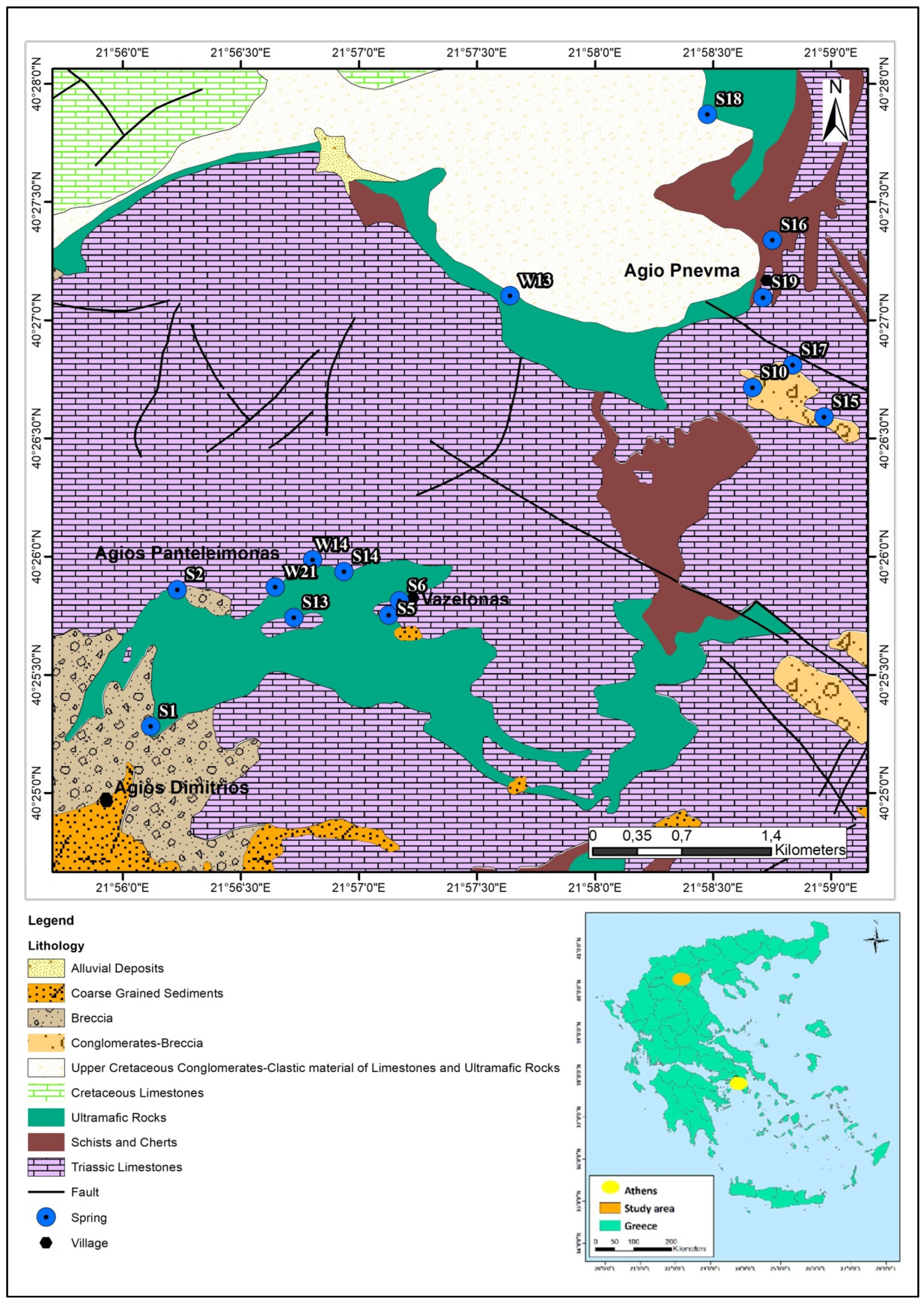
The present study is focused on the western Vermio Mt., located in the eastern part of the Sarigkiol Basin, Western Macedonia, Greece. The altitude of Vermio Mt is 2025 m and the average altitude of the basin is 650 m. The study area lies between the latitudes 40°25′00″ and 40°28′00″ E and the longitudes 21°56′00″ and 22°59′00″ N (
Figure 1). In this area, any extensive anthropogenic activities lack except for local livestock farming and sporadically logging.
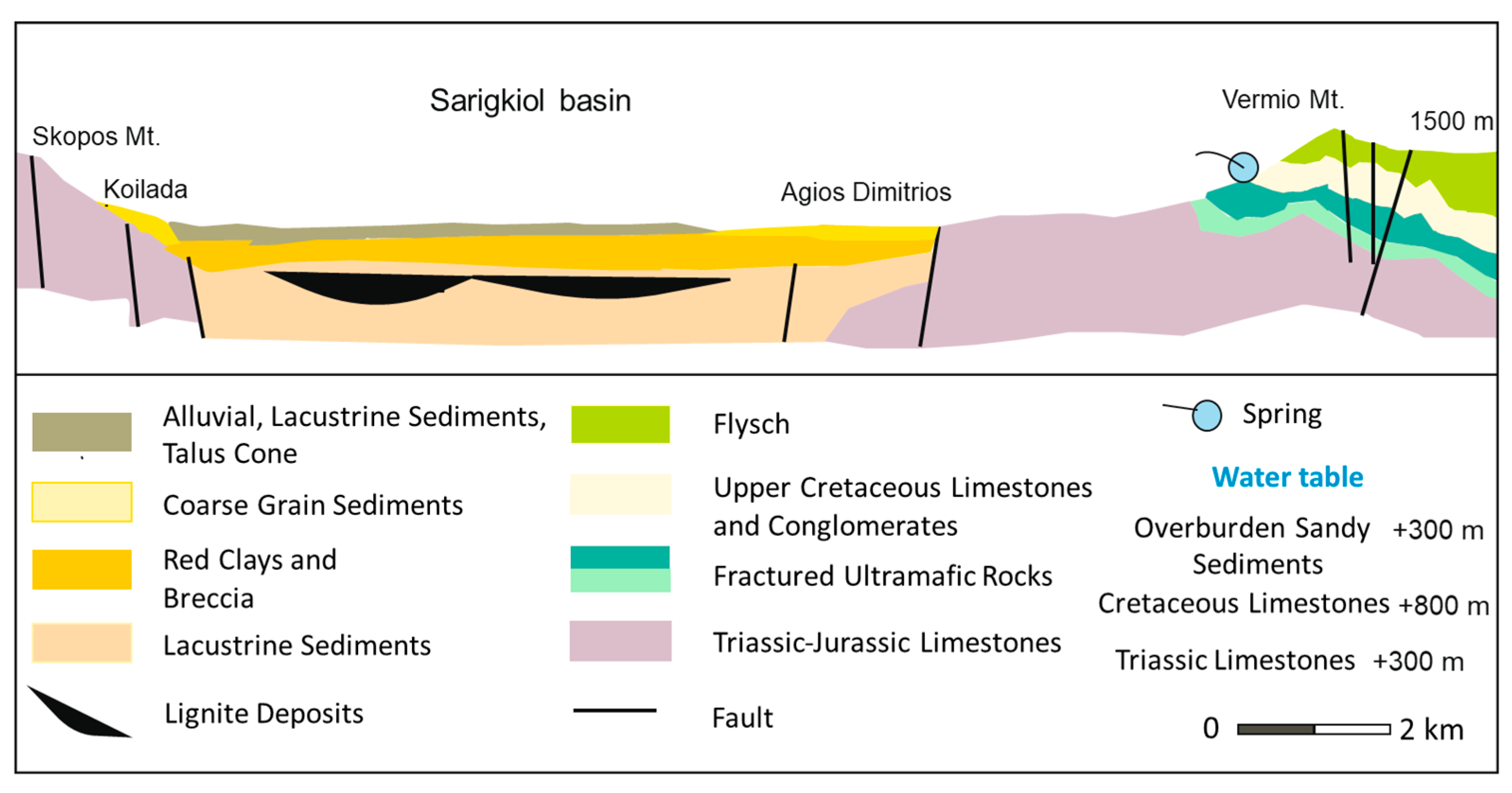
2.2. Geological and Hydrogeological Setting
The western Vermio Mt. is composed of (
Figure 1 and
Figure 2) [
46,
47]: (a) alluvial deposits, (b) clastic conglomerates, talus cones, and breccias, (c) upper Cretaceous flysch, (d) a complex of schists and cherts formations, (e) ultramafic rocks (serpentinites and peridotites), (f) Triassic–Jurassic limestones, (g) Cretaceous limestones.
The aquifer systems in Vermio Mt. are:
- (a)
The deep karstic aquifer of the Triassic‒Jurassic limestones, which form the mountainous boundaries and the basement of the Sarigkiol Basin,
- (b)
Perched aquifer systems that are developed in the highly fractured serpentinites of Vermio Mt. due to secondary porosity,
- (c)
Small in size and capacity, karstic aquifers developed in the scattered Cretaceous limestones. There are many aquifers in which the water table varies from +700 up to +900 m. They are hydraulically connected and recharge the groundwater of the screes and talus cones in the ridges of the basin. The general flow direction of the groundwater is from the mountainous area to the center of the basin, i.e., NE–SW.
Different types of natural springs flow out in Vermio Mt. and specifically (
Figure 1):
Contact springs formed where permeable formations (limestones, breccia, conglomerates) overlay formations of low permeability or impermeable (altered ultramafic rocks/serpentinites). Contact springs studied here were: the springs S19, S10, S15 in the Agio Pnevma area, the “Potistis”‒W13 spring, the spring S1 in the Agios Dimitrios area, the spring “Mouratidis”‒S2, the springs S13, S14 in the Agios Panteleimonas area, and the springs S5 and S6 in the Vazelona area.
Fault springs formed where impermeable rocks such as ultramafic rocks are in contact with an unconfined aquifer due to faulting; the springs “Elafakia”‒W14 and W21 in the Agios Panteleimonas area belong to this type.
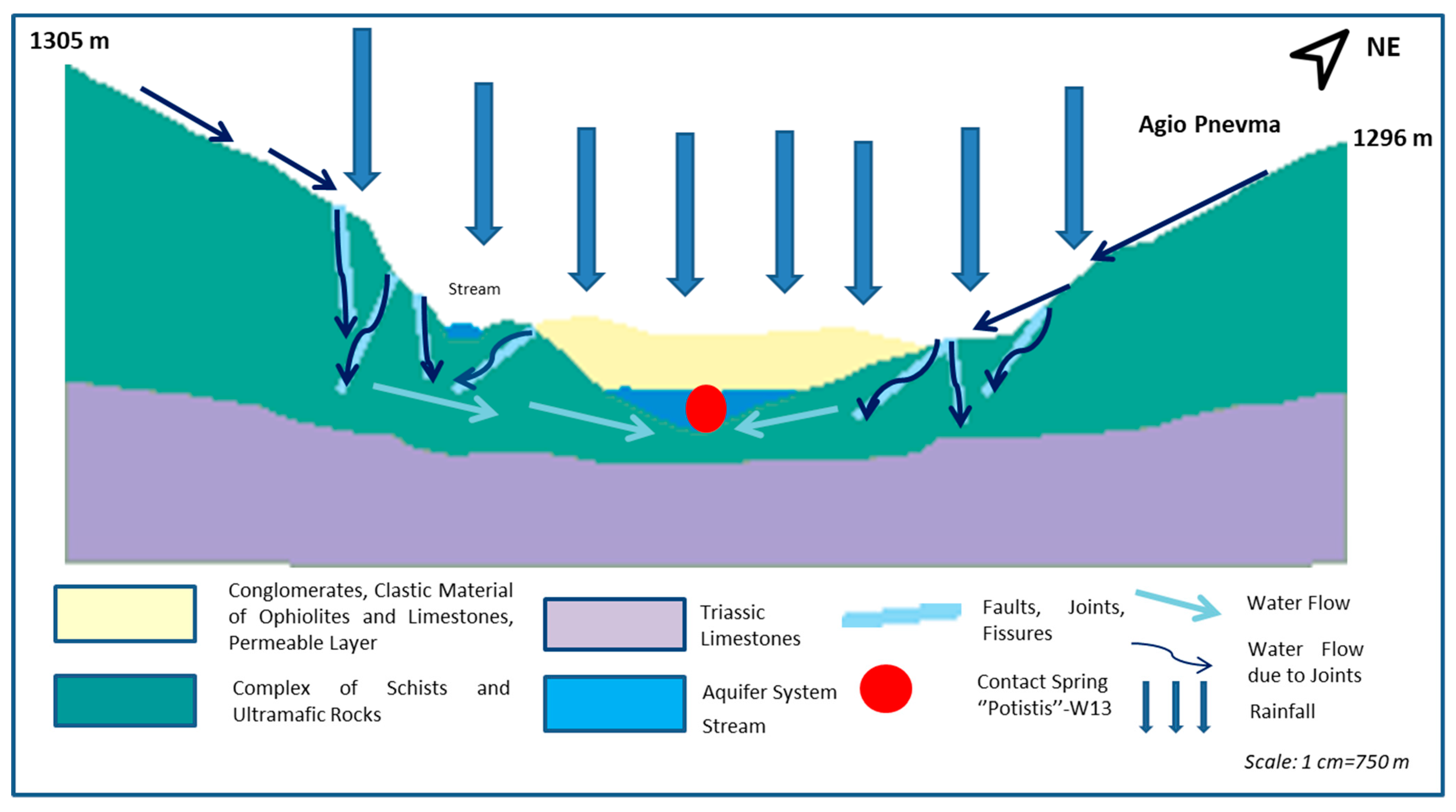
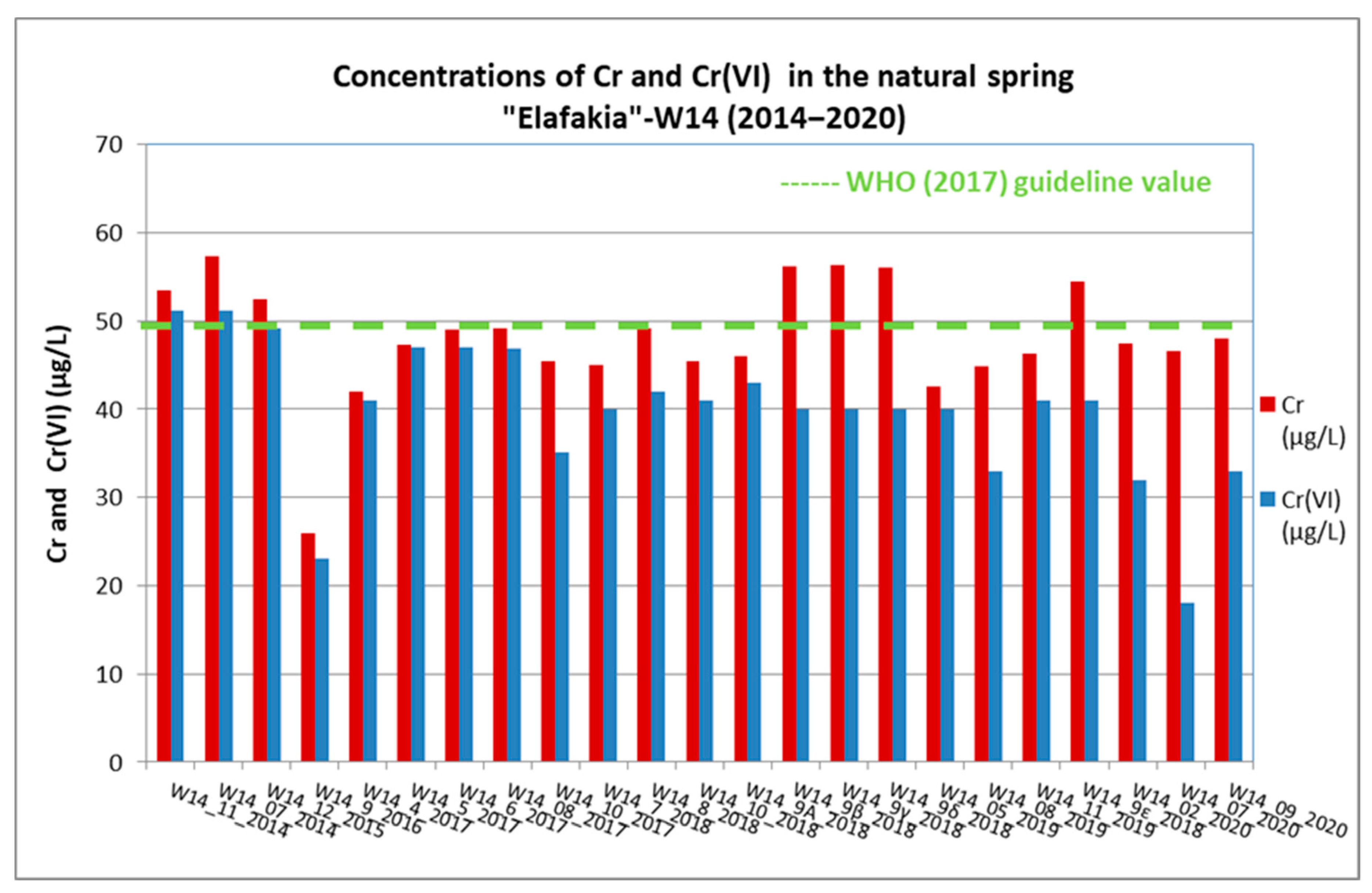
The spring “Potistis”‒W13, presents great interest, because of the very high concentrations of Cr it exhibits [
45]. The spring “Potistis”‒W13 flows out at an elevation of 1300 m in an ultramafic environment characterized by the absence of any anthropogenic activities. It constitutes a contact-type spring in the contact of conglomerates with ultramafic clastic material and limestones and ultramafic rocks. The aquifer, which discharges via the spring, flows through a weathered zone in serpentines. The natural recharge comes mainly from the seasonal precipitations via the permeable upper unsaturated zone (conglomerates, clastic material of ultramafic rocks, and limestones). The recharge water is mainly enriched with released PTEs (mainly Cr) from the ultramafic rocks, as the rainfall infiltrates through the weathered fractured ultramafic rocks. An additional lateral recharge takes place due to secondary porosity in the fractured ultramafic rocks. The high permeability of the unsaturated zone due to the presence of conglomerates in this area facilitates the direct recharge of the aquifer in a short time. The range of discharge was calculated from 205 L/h up to 1200 L/h, with an average value of 482 L/h. In
Figure 3, the simplified hydrogeological section describes the natural recharge and the operation mechanism of the spring “Potistis”‒W13.
In western Vermio Mt. ultramafic rocks, mainly serpentinites, carbonates, schists and cherts occur [
48]. The main mineral phases of the ultramafic rocks, depending on the degree of serpentinization, are serpentine [(Mg, Mn, Fe, Co, Ni)
3−xSiO
2O
5(OH)
4], olivine [(Mg,Fe
2+)
2(SiO
4)]), pyroxene [(Mg,Fe
2+)(Si,Al)
2O
6]
, talc [Mg
3Si
4O
10(OH)
2], chlorite [(Mg,Fe
2+)
5Al(Si
3Al)O
10(OH)
8], tremolite [Ca
2(Mg,Fe
2+)
5Si
8(OH)
2O
22(OH)
2], magnetite (Fe
2+Fe
23+O
4) and Cr-rich magnetite [Fe
2+(Fe
3+,Cr)
2O
4] and chromite (FeCr
2O
4).
2.3. Sampling, Chemical Analyses, and Data Treatment
Springs to be systematically studied herein were selected based on their hydrogeochemical characteristics [
45]. A total of 70 representative groundwater samples were collected from 15 natural springs during wet and dry periods from March 2014 to September 2020, following the groundwater sampling guidelines [
49]. The 15 sampling sites (
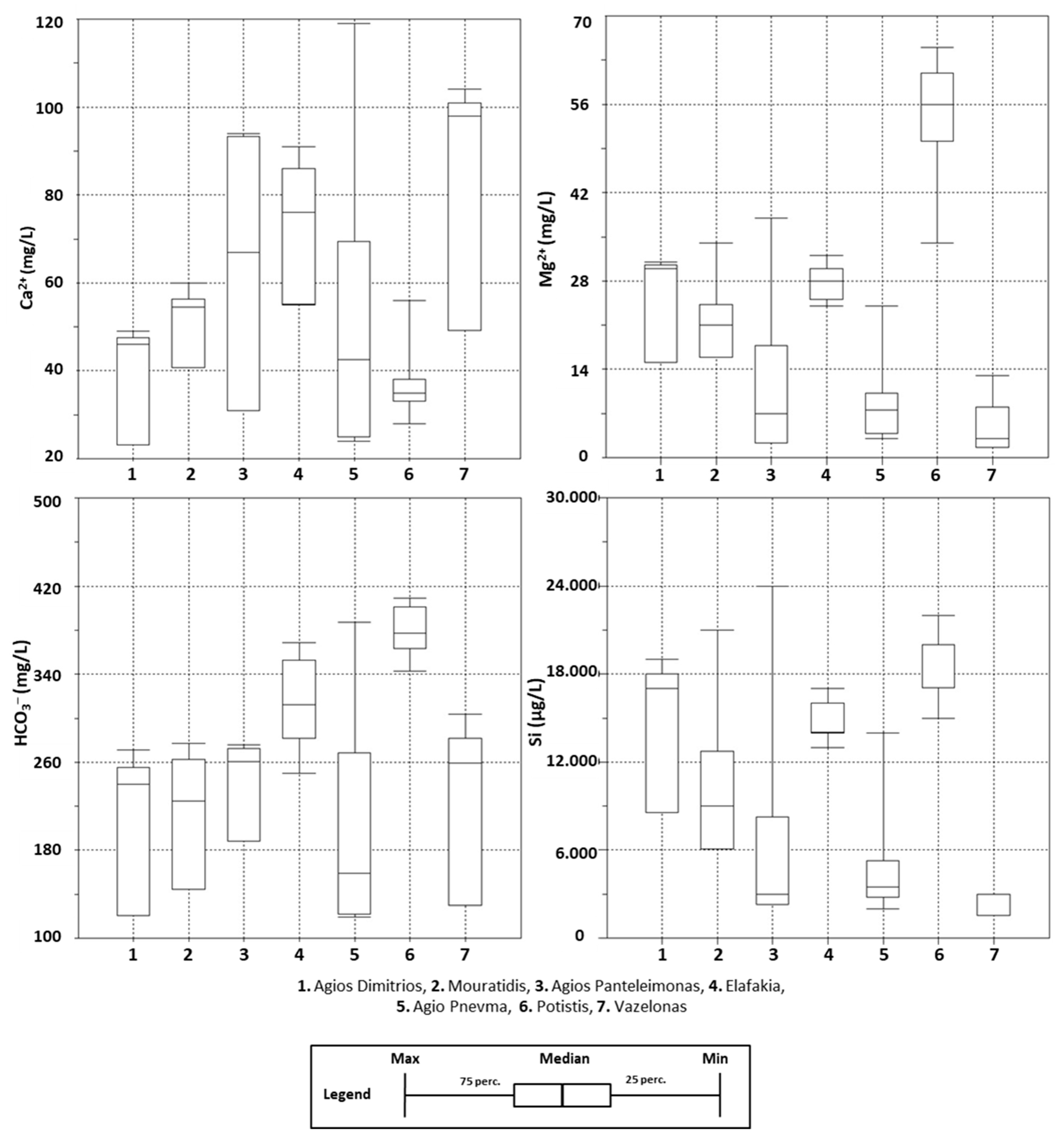
Figure 1) were classified into seven groups according to their location, lithology, and type: (i) twenty-three (23) samples were collected from the spring “Potistis”‒W13, (ii) seven (7) samples from the Agio Pnevma area (S18, S16, S19, S10, S17, S15), (iii) twenty-three (23) samples from the spring “Elafakia”‒W14, (iv) three (3) samples from the Agios Panteleimonas area (S13, S14, W21), (v) ten (10) samples from the spring “Mouratidis”‒S2 (vi) two (2) samples (S5 and S6) from the Vazelona area, and (vii) two (2) samples from the spring S1 in the Agios Dimitrios area. Considering that the number of the water samples differs between the seven groups, each group has been treated and evaluated separately (the statistical and geochemical analysis), so the analyses are classified as reliable.
The analytical methods for the determination of physical [i.e., temperature (T), pH, oxidation-reduction potential (ORP), DO, and electrical conductivity (EC)] and chemical parameters (i.e., major ions, PTEs, and other trace elements) are provided in detail in Papazotos et al. [
33]. The calculations of Eh and the total dissolved solids (TDS) values were carried out by converting ORP measurements (i.e., adding 200 mV) and the summation of major ions in each collected water sample, respectively.
AquaChem 5.0 software was used to elaborate chemical analyses, develop a Piper diagram, and calculate alkalinity. The statistical analyses of the chemical data were performed with SPSS 22.0 software.
2.4. Spearman’s Rank Correlation Coefficient
Spearman’s rank correlation coefficient (ρ, also signified by r
s) measures the strength and direction of association between two ranked variables, evaluating the degree of linear association or correlation between these independent variables. It presents many similarities to Pearson’s coefficient except that it operates on the ranks of the data rather than the raw data [
50].
The Spearman’s rank correlation coefficient is calculated according to the following Equation (1) [
51]:
where d
i = difference in paired ranks, n = number of cases, x
i and y
i = data pair.
The formula to use when there are tied ranks is Equation (2):
The Spearman’s rank correlation coefficient, rs, can get values from −1 to +1. The equation for the calculation is developed so that it gives rs = +1 when the data pairs have a perfect positive correlation (di = 0) and rs = −1 for the perfect negative correlation, whereas rs = 0 indicates no association between ranks. The closer rs is to zero the weaker the association between the ranks is.
The values of the correlation coefficient are classified as very strong (0.80–1), strong (0.60–0.79), moderate (0.40–0.59), weak (0.20–0.39), and very weak (0.00–0.19) [
52]. The correlation coefficient is highly statistically significant, marginally statistically significant when the
p-value is
p < 0.01,
p < 0.05.
2.5. Shapiro‒Wilks Test
Shapiro–Wilks is a test of normality in frequentist statistics. The null hypothesis of this test is that the dataset is normally distributed. Thus, if the
p-value is less than the chosen alpha level (0.05 in this case), then the null hypothesis is rejected and the data tested are not normally distributed. If the
p-value is greater than the selected alpha level, then the null hypothesis cannot be rejected (Equation (3)) [
53].
where x
(i) is the i-th largest order statistic, x- is the sample mean, and n is the number of observations.
2.6. Quantile–Quantile Plot
The quantile‒quantile (q–q) plot is a graphical tool for defining if two datasets come from populations with a common distribution [
54], basically tests the conformity between the empirical distribution and the given theoretical one. On a Q–Q plot normally distributed data, the points in a Q–Q plot will fit on a straight diagonal line.
2.7. Geochemical modeling
The geochemical software PHREEQC version 3.1.2 [
55] coupling with the MINTEQ database was used to calculate the saturation indices (SIs) of natural spring samples. Mineral SIs employed to define mineral dissolution and precipitation processes in the natural springs of western Vermio Mt. Saturation index is calculated by the Equation (4):
where IAP = ion activity and K
sp = solubility product constant.
A positive SI indicates that the mineral is oversaturated or supersaturated with respect to the solution [
56]; thus, the mineral could precipitate. Conversely, a negative SI indicates that the solution is undersaturated with respect to the selected mineral, suggesting that the mineral is dissolved in groundwater to reach equilibrium.
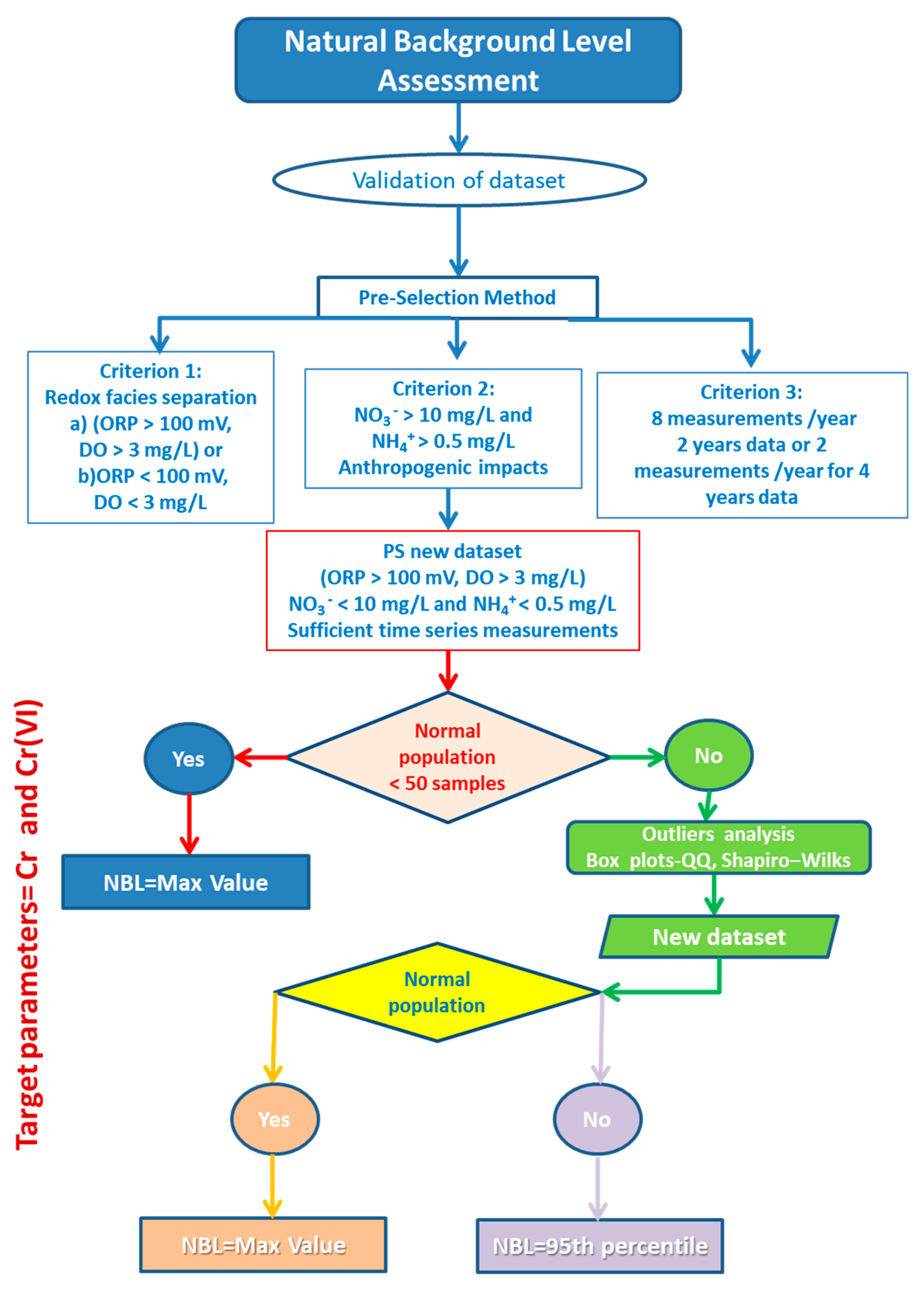
2.8. Calculation of NBLs of Cr
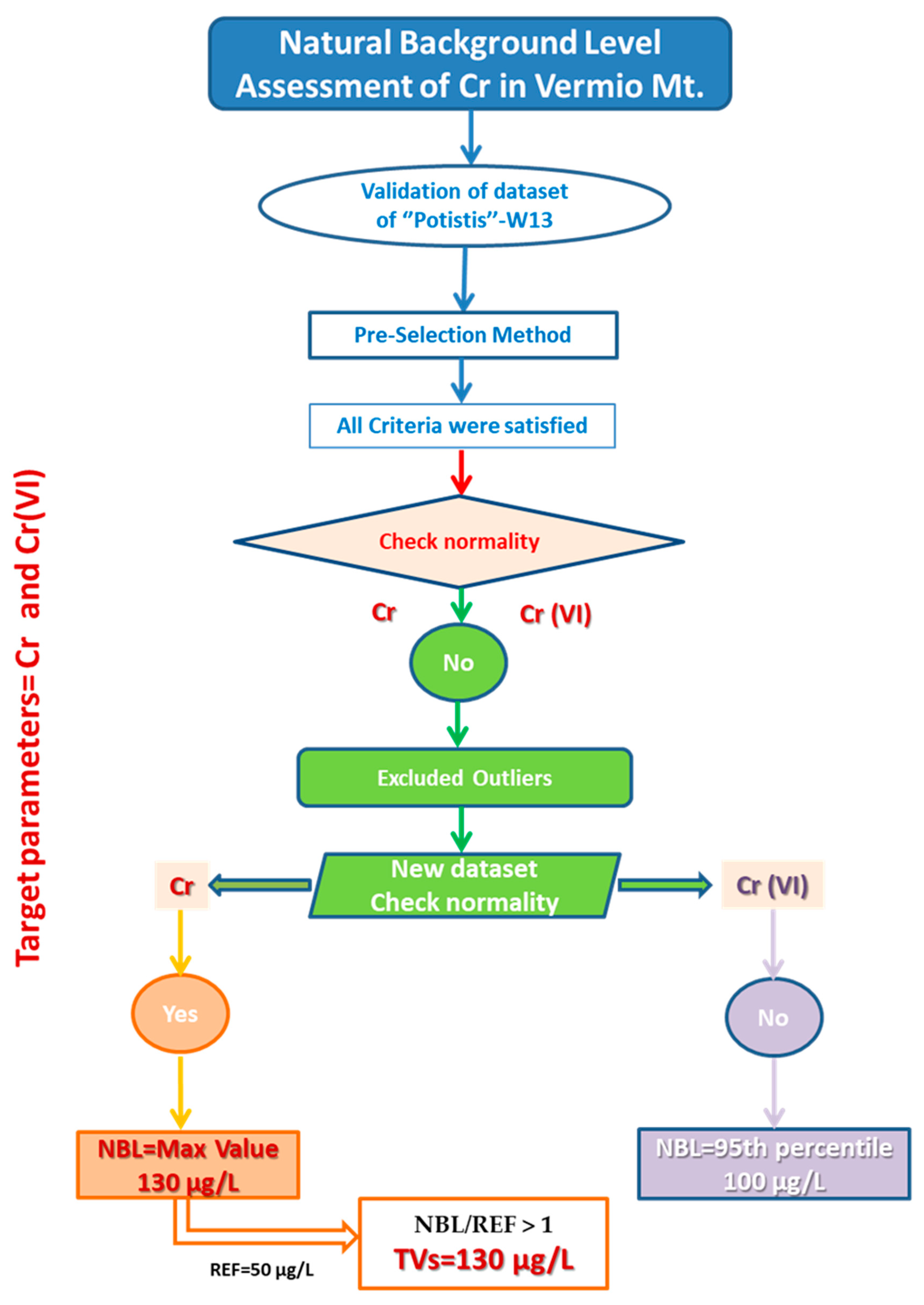
The assessment of NBLs for the target parameter was implemented based on the BRIDGE methodology [
11]. The applied modified multi-method was separated into three steps: (a) the hydrogeochemical (bivariate plots, Piper, SI), (b) the PS method, and (c) the statistical analysis for estimating the NBLs (box plots for outliers, Q–Q (quantile–quantile) plots, and normality tests).
The applied methodology for the assessment of NBLs of Cr is described in detail in
Figure 4. The pre-selection (PS) method, which is widely applied worldwide, was employed to select the suitable spring water samples for the NBLs assessment [
10,
16,
57,
58,
59,
60]. The PS method constitutes the methodology geochemical approach to validate the dataset according to similar geochemical characteristics and recognize the water samples that are affected by anthropogenic activities. In the first stage, the hydrochemical facies were selected based on the DO concentrations and Eh (ORP) [
61]. The first dataset group included the water samples with ORP > 100 mV and DO > 3 mg/L. All water samples from the natural springs satisfied this criterion. The next criterion included consideration of redox conditions; if the prevailing conditions were oxidizing, then the concentrations of NO
3− < 10 mg/L would be considered and if the conditions were reducing, then the NH
4+ < 0.5 mg/L would be considered [
9,
61,
62] to exclude the samples affected by anthropogenic activities [
62,
63]. Based on this criterion, the samples with NO
3− > 10 mg/L were considered to be affected by anthropogenic activities and thus, were excluded from the new dataset. The next criterion required eight measurements per year for two years or two measurements per year for at least four years to exist for each spring [
16].
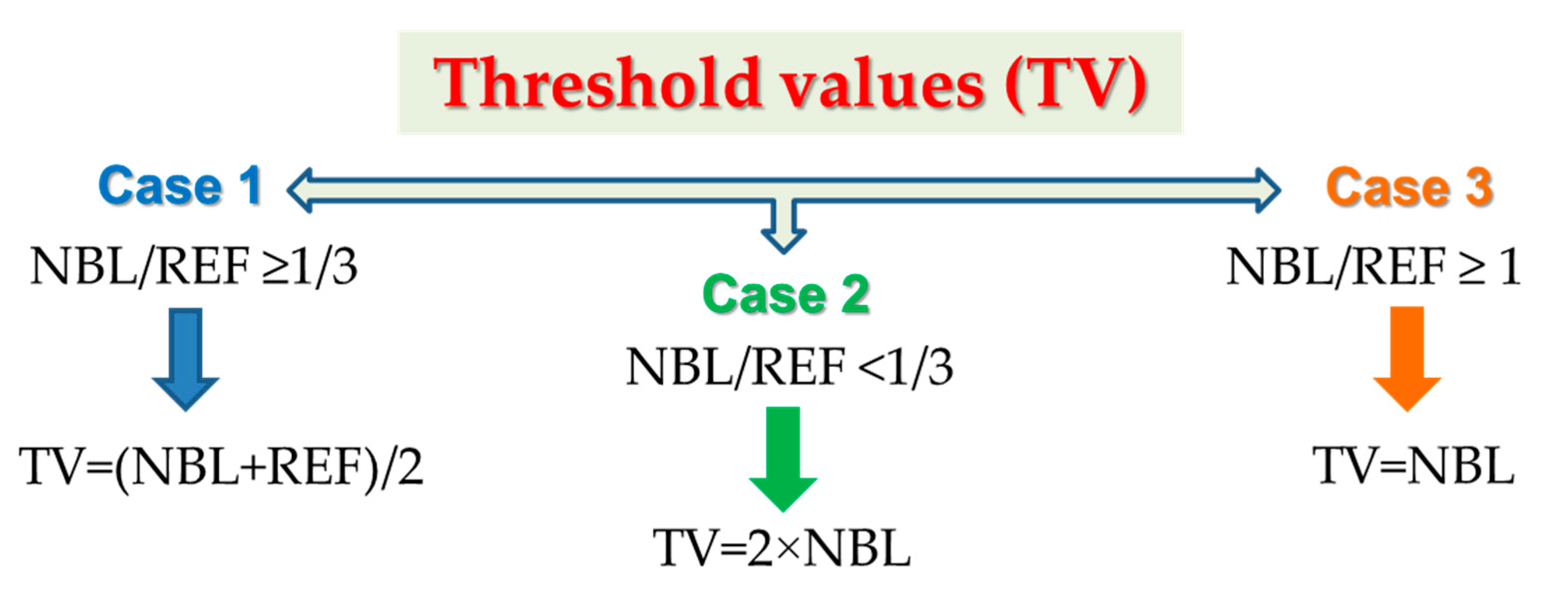
2.9. Threshold Values (TVs) Derivation
The assessment of TVs was based on three scenarios [
11,
58] (
Figure 5). The reference value was set equal to the water drinking acceptable limit (i.e., World Health Organization (WHO) guideline value).
2.10. Meteoric Genesis Index (MGI)
The meteoric genesis index (MGI) was also employed to classify the groundwater sources based on the depth of the meteoric water [
64]. This index was calculated using the following Equation (5):
when r
2 < 1, the groundwater source is of deep meteoric water percolation type whereas when r
2 > 1 the groundwater is of shallow meteoric water percolation type [
65].
2.11. Meteorological Data
Daily and monthly rainfall data for the period 2014–2019 were evaluated from the meteorological station in the Ermakia village (40°30′325″ N, 21°51′233″ E) which is the most representative and the nearest one, located on Vermio Mt., at an elevation of 1100 m. The annual precipitation for the period 2014–2019 was estimated at 985 mm.
4. Discussion
4.1. Hydrogeochemical Characterization of the Natural Springs of Western Vermio Mt. the Ultramafic Fingerprint
The dominant hydrochemical types of the studied natural springs of western Vermio Mt. were Ca-Mg-HCO
3 (40% of the water samples), Mg-Ca-HCO
3 (33% of the water samples), and Ca-HCO
3 (21%) (
Figure 12). Other transitional water types in the study area comprised Ca-K-HCO
3-Cl (3%) and Ca-HCO
3-SO
4 (3%). Based on the type and the geological environment of the springs, the Ca–HCO
3 waters are considered to originate through the interaction of meteoric water with rocks containing Ca-bearing minerals, whereas water types enriched in Mg, were derived from the dissolution of ultramafic rocks [
29]. The mixed Ca-Mg-HCO
3 type indicated fresh recharge waters mainly related to carbonate rocks and less to ultramafic rocks. The Mg-Ca-HCO
3 water type represents recharge waters related to Mg-rich rocks, suggesting the strong interaction with the ultramafic rocks of the area [
67]. The springs “Potistis”‒W13, S1, and W21 that belong to this type are associated with fissured aquifers in strongly serpentinised ultramafic rocks, or they are in hydraulic connection with them.
The water–ultramafic rock interaction typically produces Mg-HCO
3 water type [
33,
40,
68] and slightly alkaline to strongly alkaline pH conditions [
69] because of the absorption of dissolved CO
2 from atmospheric water in the serpentine and olivine according to the Equations (6) and (7) [
70]:
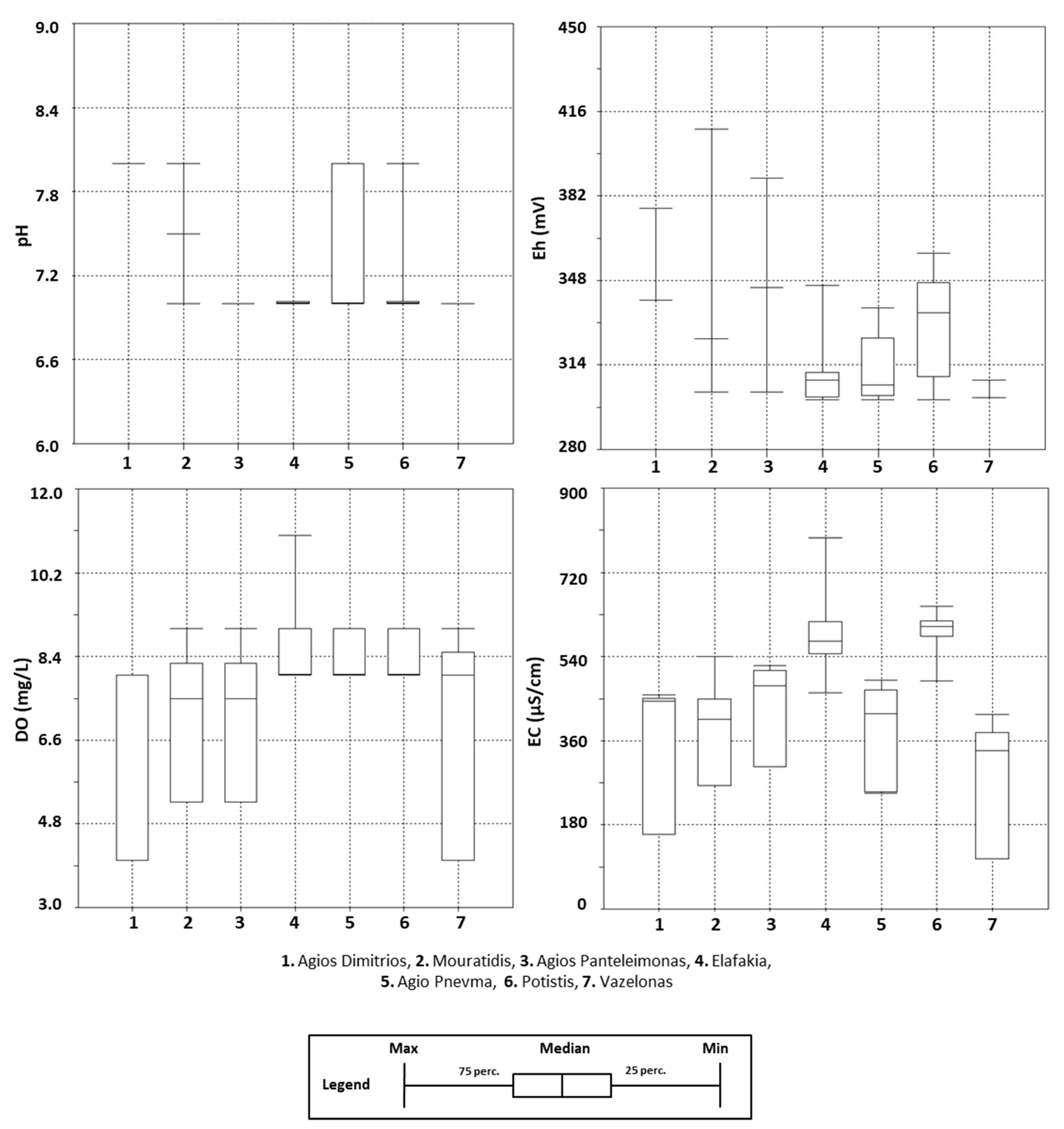
The pH values that characterised the studied springs varied from 7.3 up to 8.5, indicating near-neutral to slightly alkaline conditions that are typical of groundwater interacting with ultramafic and carbonate rocks [
40,
71]. Redox potential conditions were oxidizing up to strong oxidizing, as indicated by Eh, ranging from 300 mV up to 410 mV. The pH and Eh conditions in the studied springs favoured the release and solubility of the Cr oxyanion in groundwater since the solubility of oxyanions such as HCrO
4−, CrO
42−, Cr
2O
72−, H
2AsO
4−, and HAsO
42− is enhanced with increasing pH [
72].
Various tools are usually employed to define and evaluate the water–rock interaction processes in an area [
73]. Bivariate plots of major ions and ionic ratios were used to study the hydrogeochemical evolution processes in the studied springs (
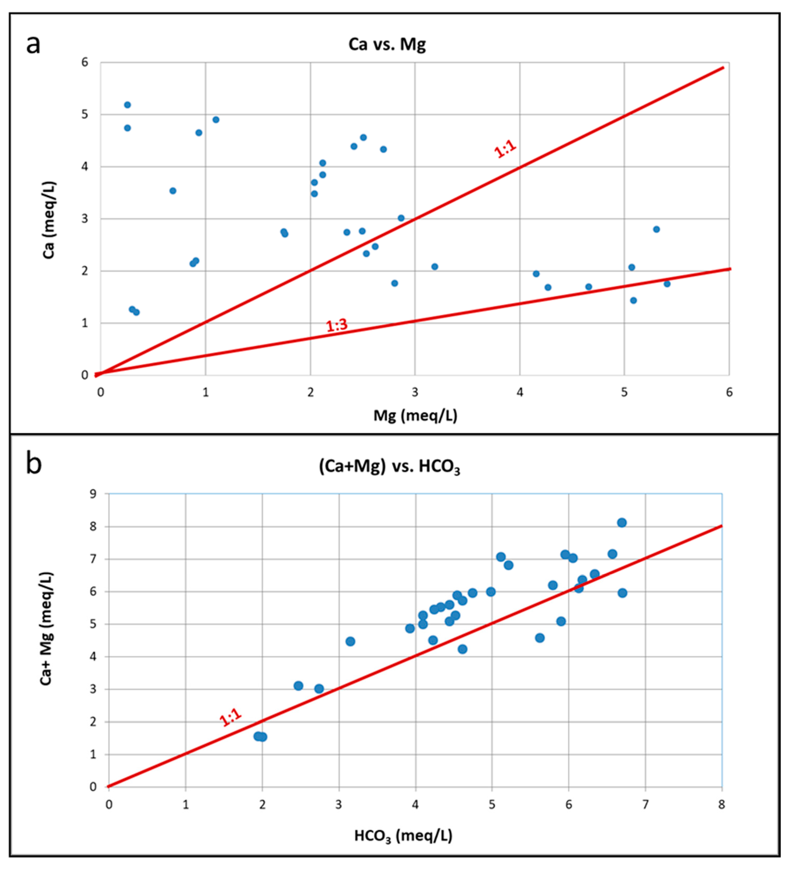
Figure 13). In the bivariate plot of Ca vs. Mg, the water samples were grouped into three classes based on their Ca/Mg ratio (
Figure 13a). In the first class belong the water samples with a Ca/Mg ratio below the 1:3 line. This class included two seasonal water samples from the spring “Potistis”‒W13 (W13_10_19 and W13_4_19) with a Mg-Ca-HCO
3 water type, revealing that the flow path was mainly through serpentinites. The second class contained the water samples of the natural spring S1‒Agios Dimitrios area and “Potistis”‒W13. They are all of Mg-Ca-HCO
3 type and characterized by Ca/Mg ratios plotted below the 1:1 and above the 1:3 lines; this suggests a mixture of Mg-HCO
3 and Ca-HCO
3, indicating that these waters were derived from interaction with serpentinites and Ca-rich rocks. The third class comprised the rest of natural springs, characterized by mixed water types and a Ca/Mg ratio above the 1:1 line, indicating a limited influence of serpentinites. The bivariate plot of Ca + Mg vs. HCO
3 (
Figure 13b) suggests an excess of (Ca + Mg) over HCO
3 reflecting an additional non-carbonate source of Ca
2+ and Mg
2+ ions, such as the dissolution of silicate minerals [
38,
57]. Iron-Mg-silicates of ultramafic rocks, such as olivine, pyroxene, and amphibole are transformed to serpentine group minerals during the serpentinisation process. Dissolution reactions favour the Mg
2+ and HCO
3− release of the Mg-rich minerals (Equations (6) and (7)) [
68].
During water–rock interaction, various chemical processes (e.g., fluctuation of ionic concentrations, mobilization of the dissolved components, and change in pH) are fingerprinted on the groundwater quality [
74,
75]. Gibbs diagrams are generally used to identify the hydrogeochemical evolution of groundwater, which involves precipitation, water–rock interaction, and evaporation–crystallization processes, based on TDS vs. Na
+/(Na
+ + Ca
2+), and TDS vs. Cl
−/(Cl
−+ HCO
3−) scatter diagrams [
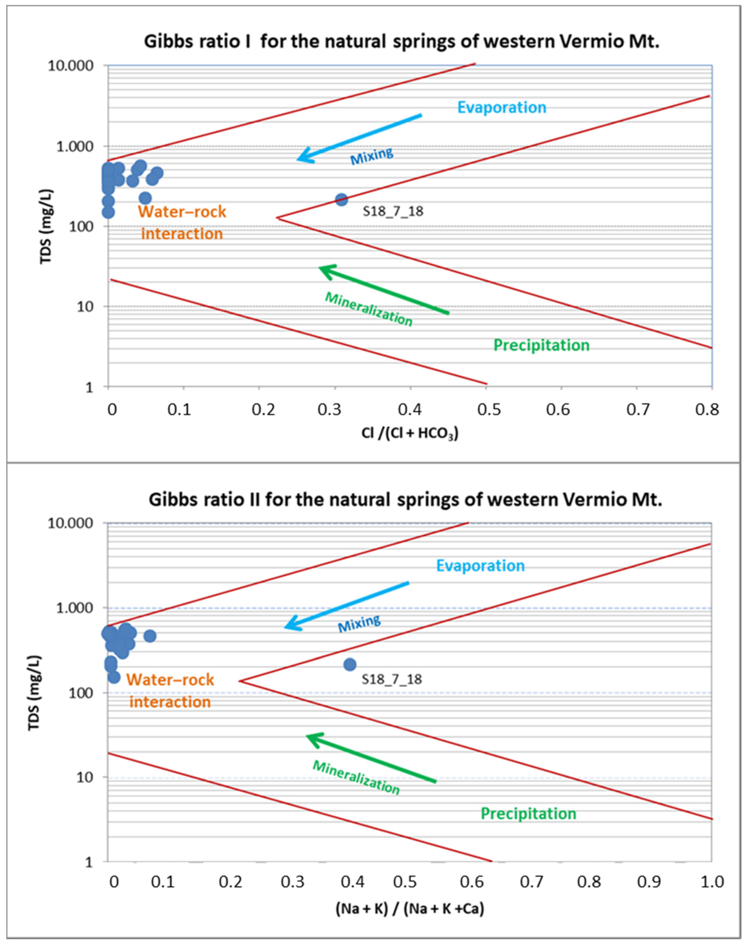
76]. Herein, Gibbs diagrams were employed to assess hydrogeochemical processes that affect the water chemistry in the natural springs of western Vermio Mt.
Figure 14 illustrates that all samples from natural springs fall into the water–rock interaction field, suggesting weathering of carbonate and silicate minerals. Although the use of Gibbs plots for groundwater has been disputed [
77], the case study discussed herein exhibits none of the characteristics that could result in misuse of these plots (e.g., high SO
42− concentrations, salinity sources, evolutionary flow paths, etc.). The implications of the Gibbs diagrams are in accordance with the calculated MGI index, according to which the waters from the natural springs are characterized as deep percolation types.
4.2. Hydrogeochemistry of Cr in Natural Ultramafic Springs
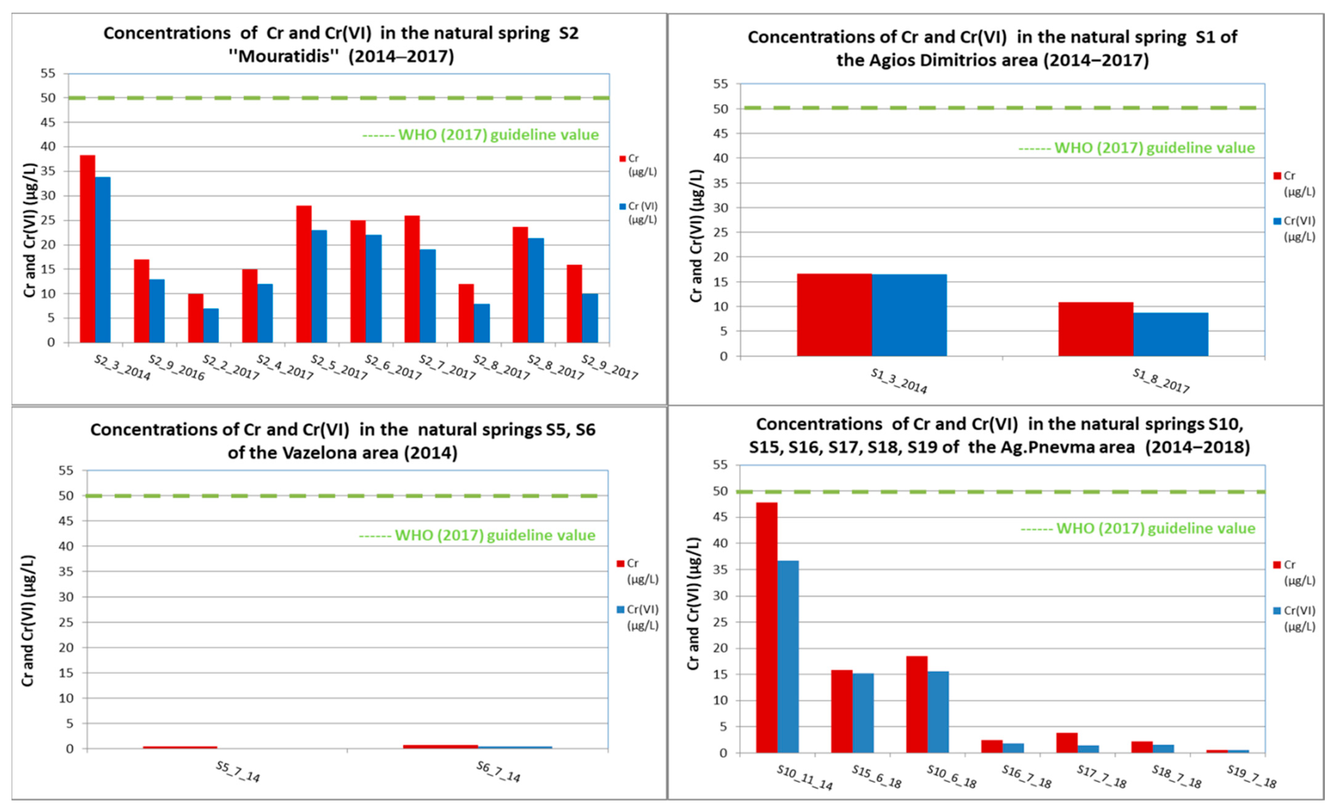
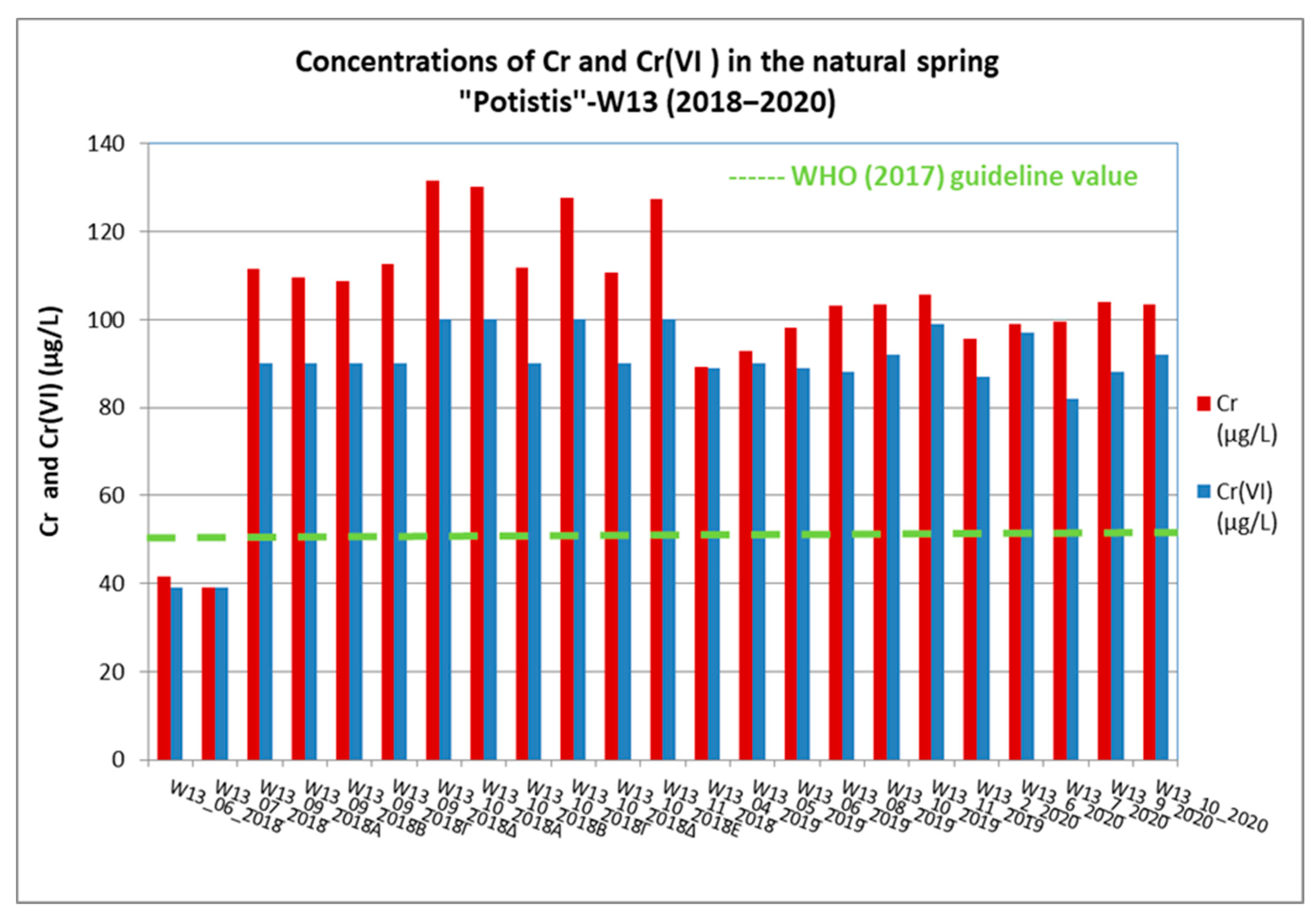
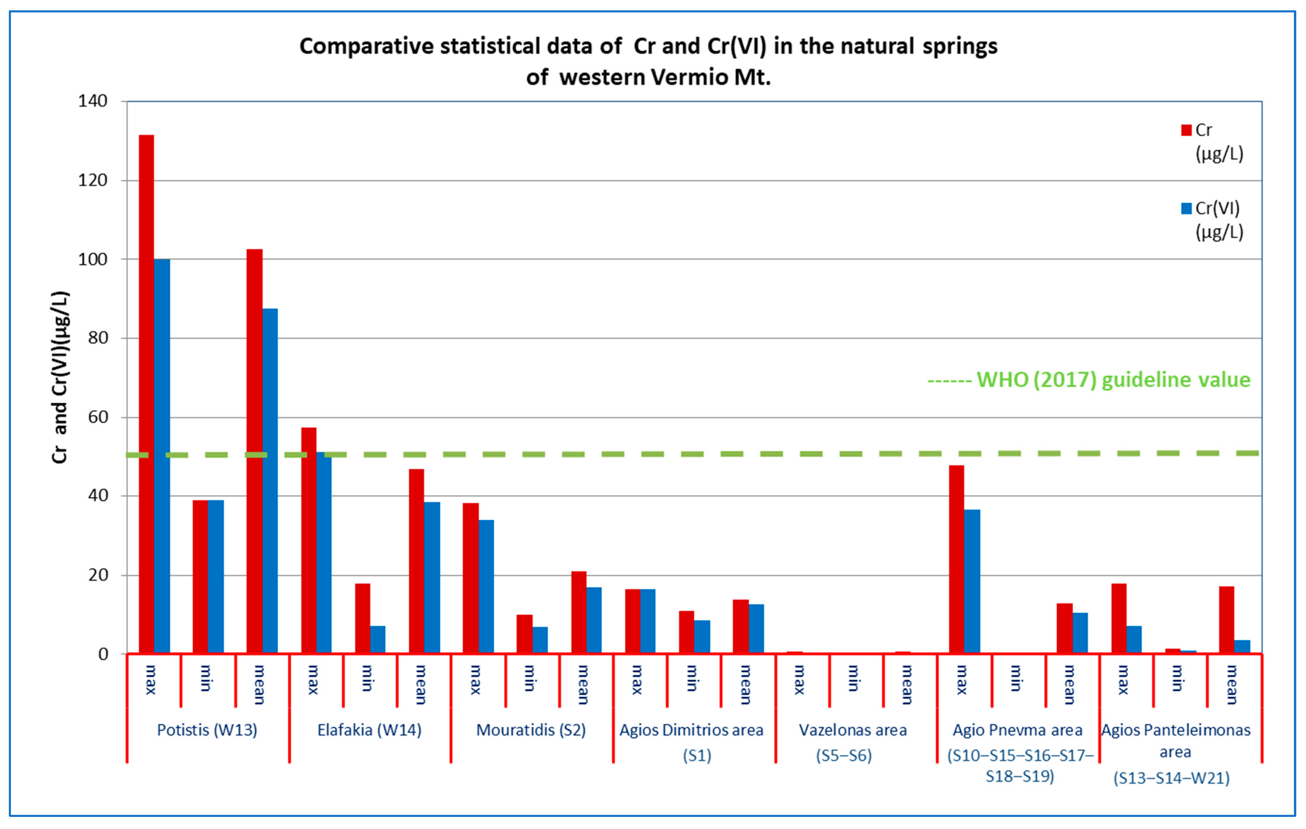
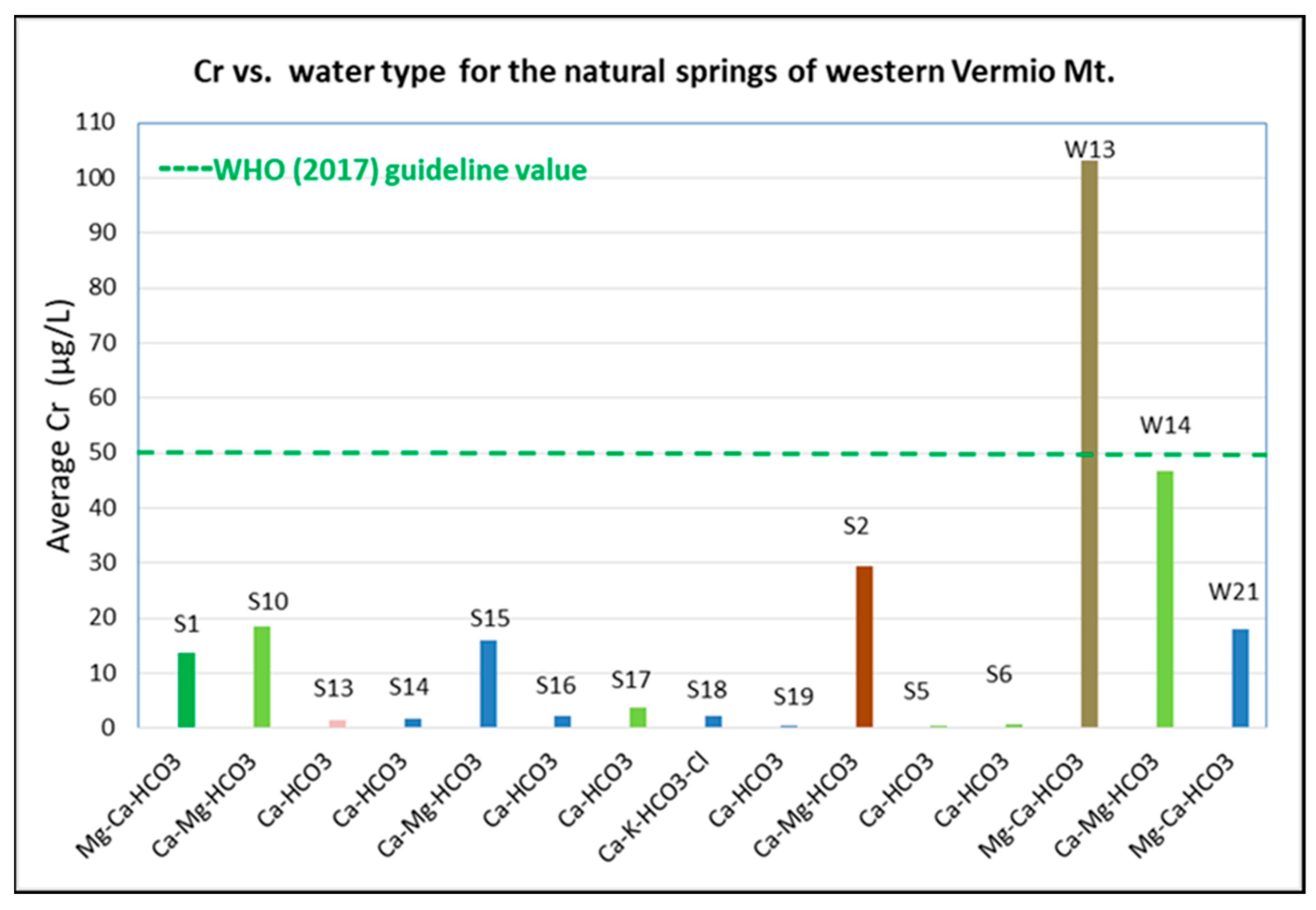
To further study the hydrogeochemistry of Cr in the studied springs, the average concentration of Cr was plotted vs. the water type of each spring (
Figure 15). As shown, each water type is characterised by a wide range of concentrations of Cr, attributed to the different operation mechanisms of the spring and the weathering degree of the host geological formations. The mixed Mg-Ca-HCO
3 water type ranges from very high concentrations of Cr, in the spring “Potistis”‒W13 (>100 μg/L), to much lower values (<20 μg/L) in the springs S1‒Agios Dimitrios area and W21‒Agios Panteleimonas area. The mixed Ca-Mg-HCO
3 water type is related to a range of concentrations of Cr from 17 to 48 μg/L. On the other hand, all springs that are characterised by a Ca-HCO
3 water type exhibit very low Cr concentrations (<5 μg/L) since mostly the carbonate rocks influence their hydrochemistry. In all springs, the dominant anion is HCO
3−, the principal source of which is the dissolution of carbonate and silicate minerals [
33].
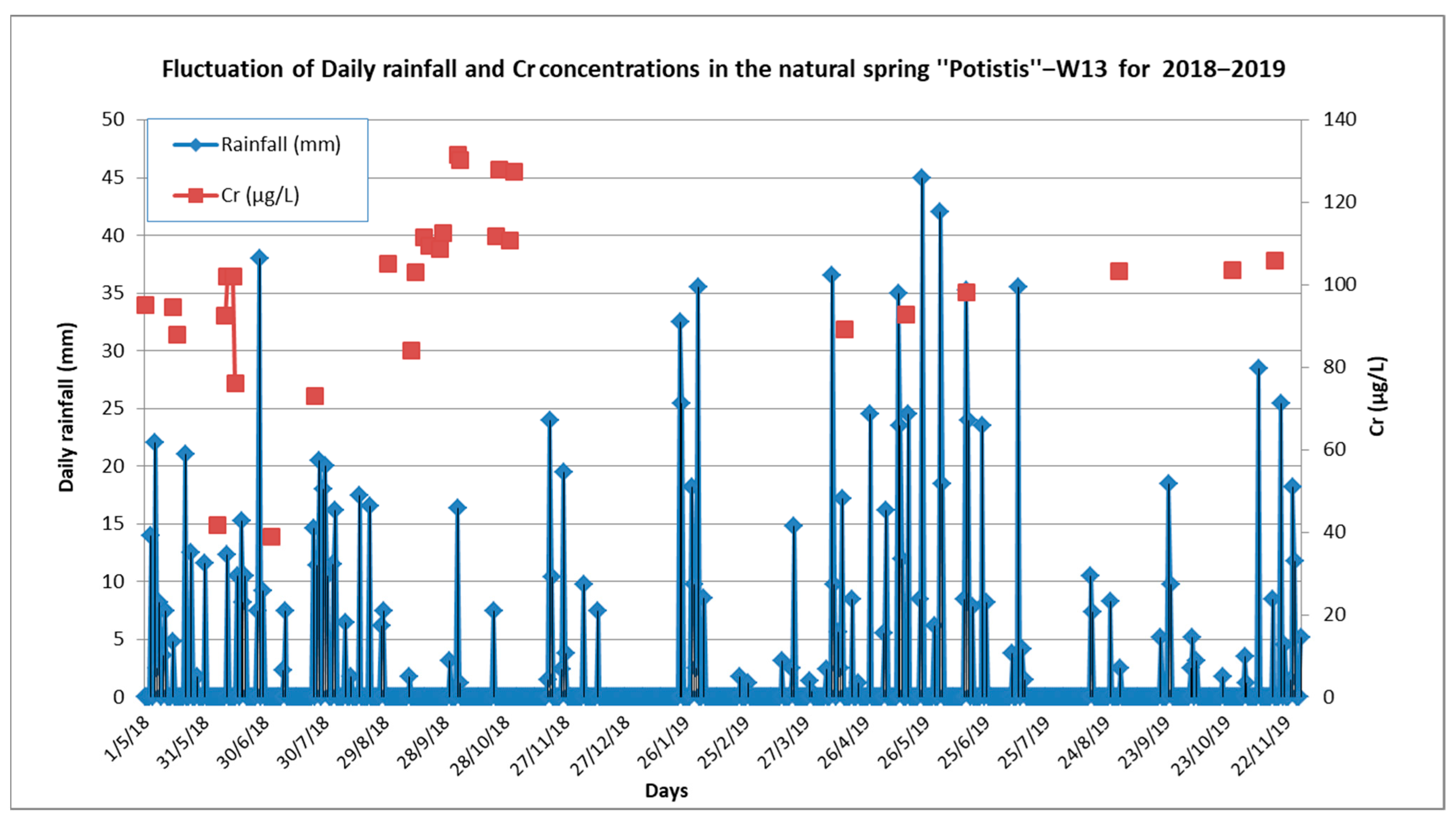
An interesting feature of the spring “Potistis”‒W13, derived from the evaluation of hydrogeochemical, hydrological, and meteorological data, is the decrease in concentrations of Cr in a very short time after rainfall; this is further supported by the strong linear regression of Cr vs. discharge (coefficient of determination R
2 = 0.85) (
Figure 16 and
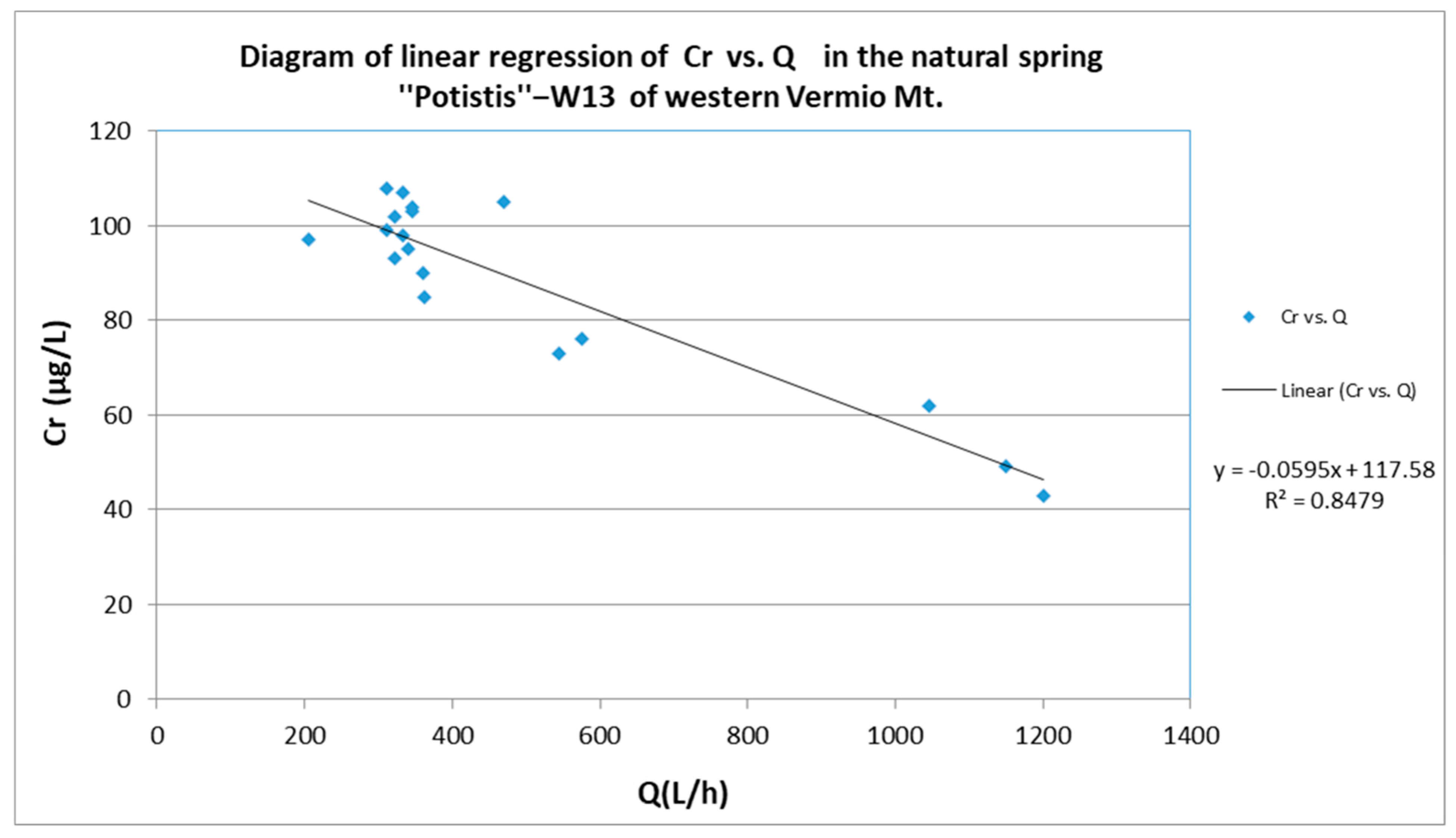
Figure 17). Low discharge results in increased water–ultramafic rock contact time and thus, in elevated concentrations of Cr.
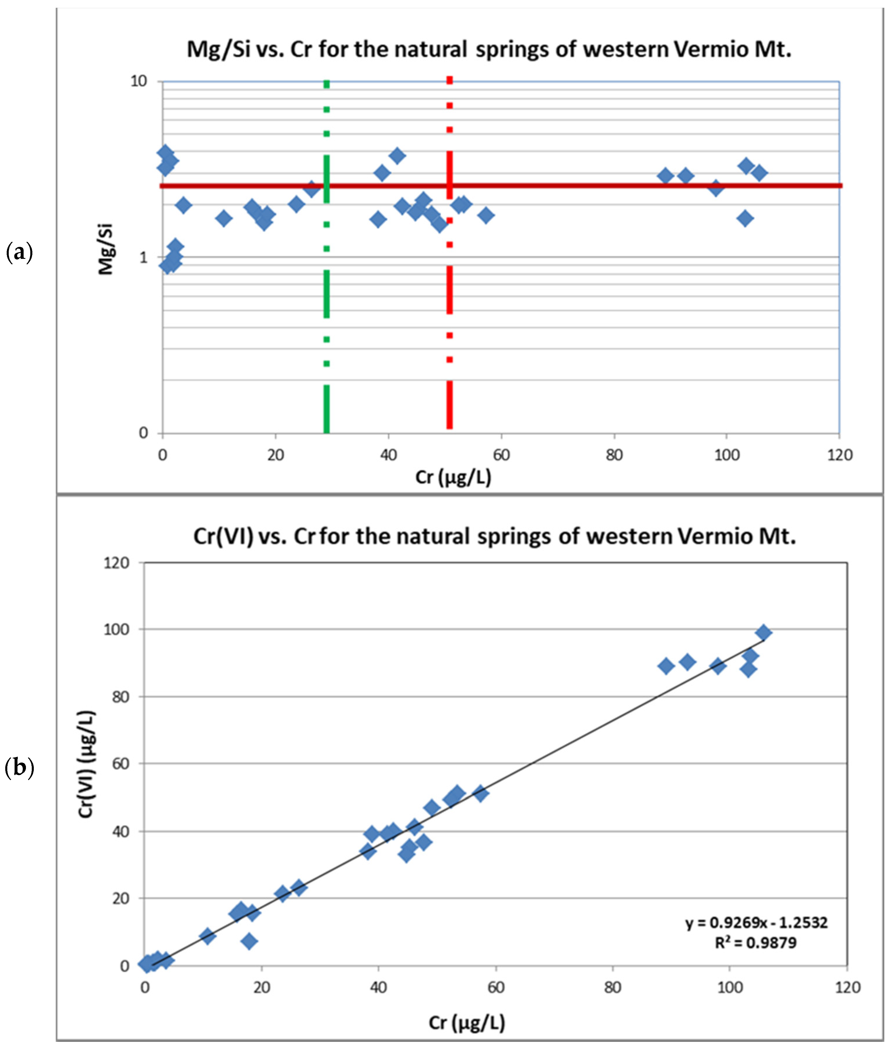
In
Figure 18a, the Mg/Si ratio vs. Cr in the springs is presented. The diagram is divided into three sub-groups according to the concentrations of Cr. The water samples with low concentrations of Cr (<30 μg/L) constituted 45.5% of the total samples, 73.3% of which exhibited a Mg/Si ratio lower than 2. Concentrations of Cr from 30 μg/L up to 50 μg/L, comprised 25% of the total water samples, 77.78% of which exhibited a Mg/Si ratio lower than 2.3; only the samples W13_6_18 and W13_7_18 which correspond to the lowest concentrations of Cr recorded in the spring “Potistis”‒W13 exhibited a Mg/Si ratio higher than 2.3. Of the total water samples, 42% exceeded the permissible limit of 50 μg/L for drinking water [
66], with most of them corresponding to samples from the spring “Potistis”‒W13. Most samples presented a Mg/Si ratio higher than 2.3. Respective Mg/Si ratios have been reported for groundwater in other natural ultramafic environments [
29,
33].
The strong fingerprint of the water–rock interaction on the spring water chemistry and the geogenic origin of Cr in groundwater are indicated by the statistically significant very strong positive correlation coefficient of Cr with Si, the strong positive correlation coefficients of Cr with Mg
2+, EC, and Ni, and the moderate positive correlation coefficients of Cr with HCO
3 and alkalinity. Magnesium and alkalinity are two parameters usually increased with increasing degree of weathering; the latter has been reported to relate to elevated concentrations of Cr in groundwater [
78]. Nickel is derived from the dissolution of Ni-bearing silicates which are released to groundwater under morphological and geochemical conditions that do not favour the occurrence of Fe-hydroxides and other secondary minerals capable of adsorbing Ni [
79]. Nickel exhibited statistically significant, moderate positive correlation coefficients with Mg
2+, EC, and Si, further highlighting its geogenic origin. The two natural springs with high concentrations of Ni (“Potistis”‒W13, “Elafakia”‒W14), also exhibit high mean concentrations of dissolved Si, and are of Mg-Ca-HCO
3 and Ca-Mg-HCO
3 water type. A similar case of high concentrations of Cr and Ni in Mg-HCO
3 groundwater has been reported by Margiotta et al. [
40]. Unlike the spring waters, Cr in the irrigational wells in the lowland of the Sarigkiol Basin was reported to strongly correlate with NO
3− and P, indicating the synergistic role of the agricultural activities [
45].
The statistically significant, very strong positive correlation coefficients of Cr with Cr(VI) (Spearman’s rank correlation coefficient r
s = 0.986) was further proven by their linear regression with a strong linear relationship (coefficient of determination R
2 = 0.99,
Figure 18b). In the analysed water samples, the Cr(VI)/Cr ratio ranges from 20% up to 100%. Specifically: (a) 62.5–90.3% in the spring “Mouratidis”‒S2, (b) 80–99% in the spring S1- Agios Dimitrios area, (c) 20–62.5% in the springs at the Vazelonas area, (d) 39–100% in the springs at the Agio Pnevma area, (e) 40–99% in the spring “Elafakia”‒W14, (f) 76–100% in the spring “Potistis”‒W13). The fluctuation in the Cr(VI)/Cr ratio depends on the prevailing geochemical conditions (redox reactions, pH), the presence of iron or manganese oxides, and competing anions in each area, suggesting that various processes take place [
78]. Hexavalent chromium is the principal form of Cr in the natural water springs (“Potistis”‒W13, S1‒Agios Dimitrios area, “Mouratidis”‒S2); several factors contribute to the high Cr(VI)/Cr ratio. Specifically, the geological environment, which is enriched in Ca and Mg-bearing minerals, enhances Cr(VI) to form complexes with Mg and Ca and inhibits Cr(VI) reduction [
71]. The presence of manganese oxides enhances the Cr(III) oxidation to Cr(VI) in ultramafic rocks, soils, and unsaturated zone releasing Cr(VI) to groundwater (Equation (8)) [
24].
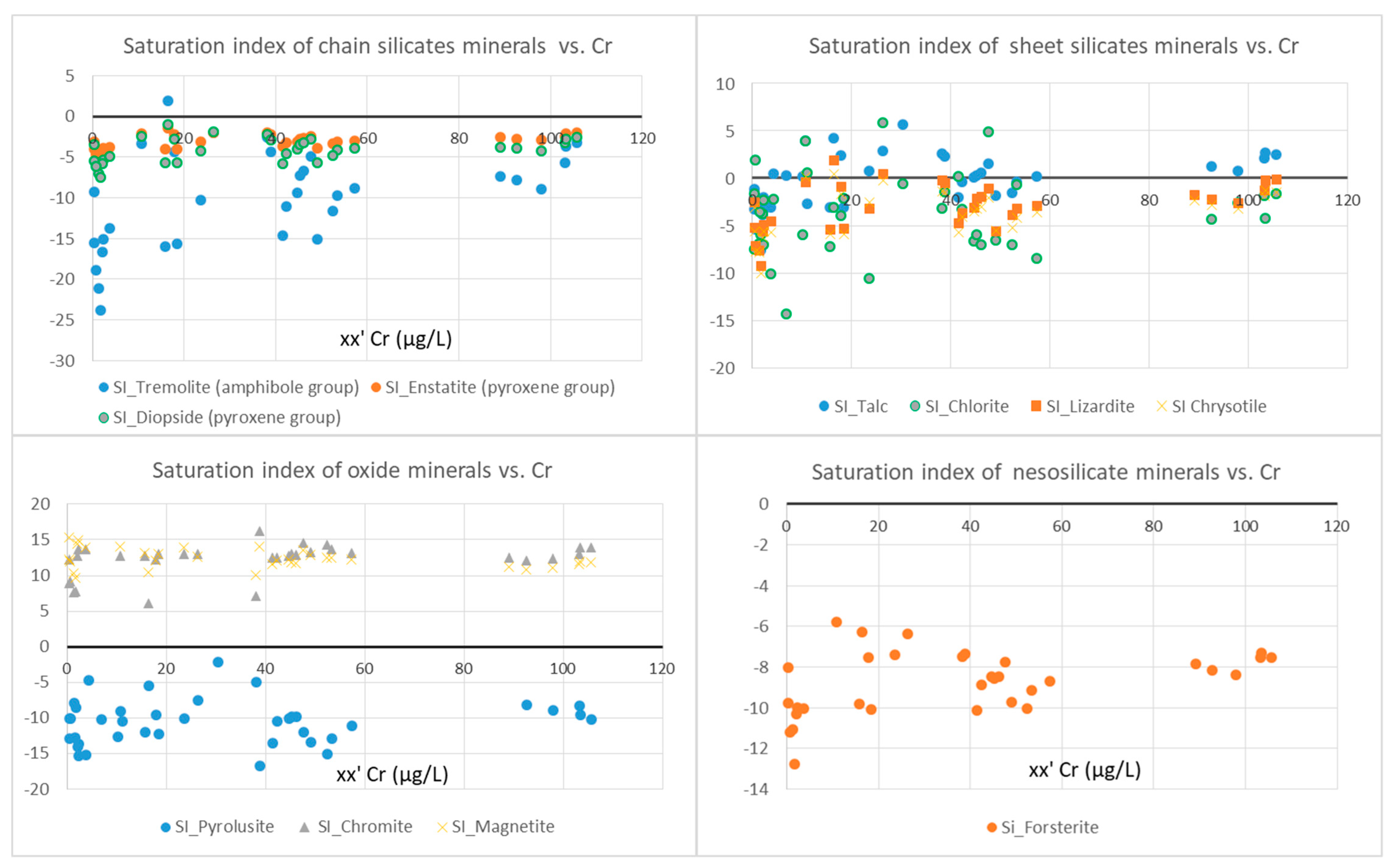
The pronounced role of minerals in the concentrations of Cr in natural springs was investigated via SIs of selected mineral phases present in the study area (
Figure 19). The percentage distribution of the SIs for the selected mineral phases is given in
Table 6 for all collected water samples.
The water samples from the natural springs in which concentrations of Cr exceeded 50 μg/L (“Potistis”‒W13 and “Elafakia”‒W14) were oversaturated in: (a) the carbonate mineral calcite (100%) and (b) the oxide minerals chromite (100%) and magnetite (100%). On the other hand, they are undersaturated in: (a) the serpentine group minerals lizardite (100%) and chrysotile (100%), (b) the pyroxenes enstatite (100%) and diopside (100%), and the amphibole tremolite (100%) and (c) the olivine (100%).
In general, the mineralogical phases that appear undersaturated tend to dissolve in water. The dissolution reactions contribute major, minor elements and PTEs to the groundwater. Chromium-bearing silicate minerals (serpentine, amphibole, pyroxene, chlorite, talc) occurred mostly undersaturated in the water samples, whereas Cr-rich oxides (chromite and Cr-magnetite) were oversaturated in the water samples. Therefore, silicate minerals are the principal geogenic contributors of Cr and other major/minor elements (e.g., Mg2+, Ca2+, HCO3−, Si) and PTEs (e.g., As, Ni) to the spring waters of western Vermio Mt.
4.3. NBLs of Cr in the Ultramafic Environment of Vermio Mt.
The geochemical characteristics of the natural springs, the geological environment, and the water–ultramafic rock interaction are reflected in springs’ water quality. Chromium constitutes the principal environmental component in groundwater of the Sarigkiol Basin, originating primarily from geogenic and incidentally from anthropogenic sources [
45]. This paper aims to assess the NBLs of Cr, which is of great interest in the catchment scale of the Sarigkiol Basin.
Based on the above-discussed hydrogeochemical data (e.g., pH, DO, Eh, Mg2+, Si, Cr, alkalinity, etc.), the most representative natural springs, which flow through and interact with ultramafic rocks, are the S1-Agios Dimitrios area, “Mouratidis”‒S2, “Potistis”‒W13, and “Elafakia”‒W14.
Take into consideration the modified methodology for assessing NBLs, the PS method was applied to create the new dataset. All samples from the natural springs satisfied the two criteria (ORP > 100 mV, DO > 3 mg/L and NO
3− < 10 mg/L). Regarding the third criterion, the available time series of measurements, two natural springs, those of “Potistis”‒W13 and “Elafakia”‒W14, sufficiently satisfied this criterion. The resulting population was examined for the normality of the dataset with the Shapiro–Wilks test, a method proposed to be appropriate for a sample size less than 50 [
80]. Although the number of the sampling sites is limited (2), they are considered representative because of the available time-series measurements, their hydrogeochemical characteristics, and the elevated concentrations of Cr, Si, Ni, and Mg
2+.
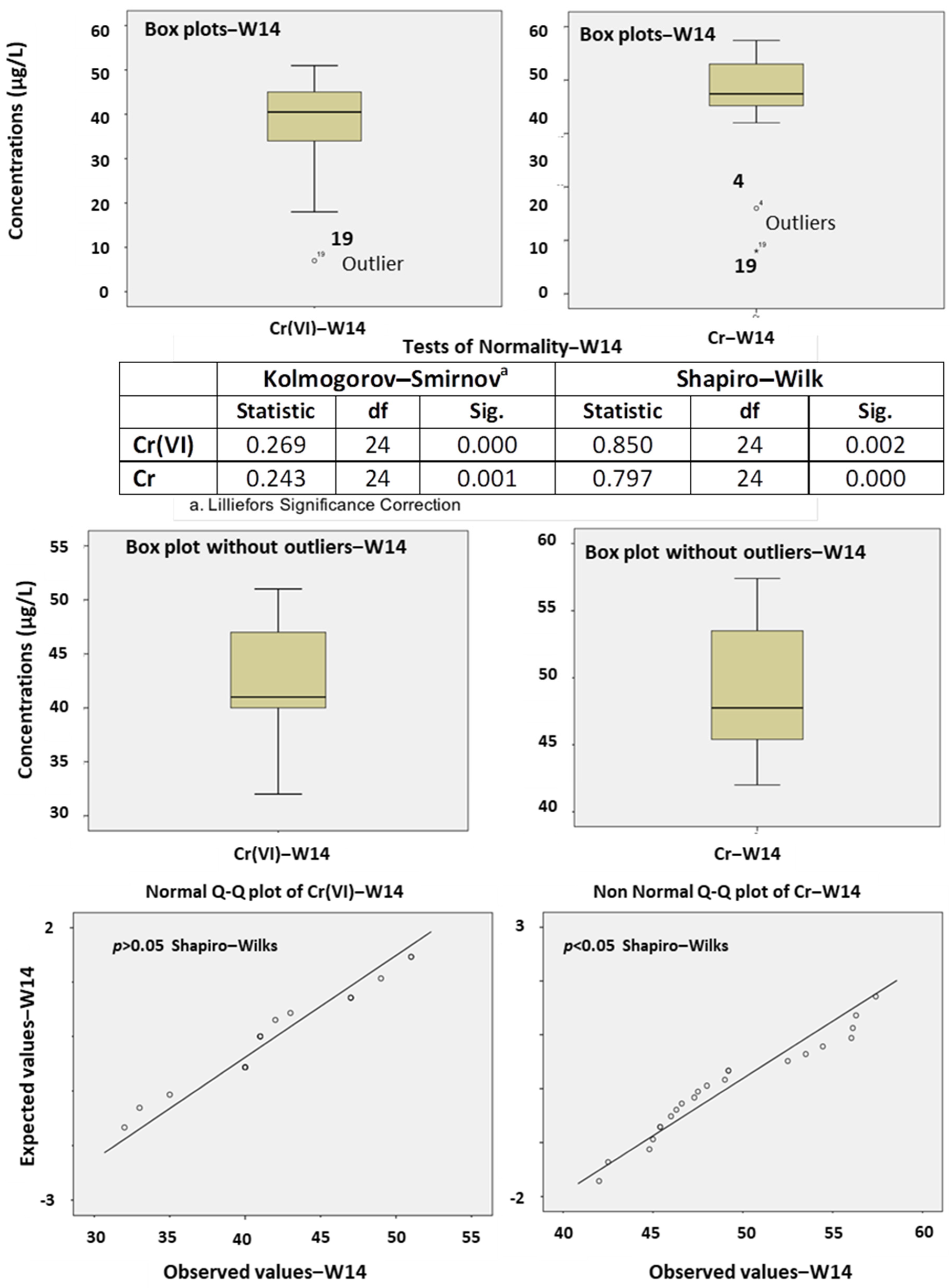
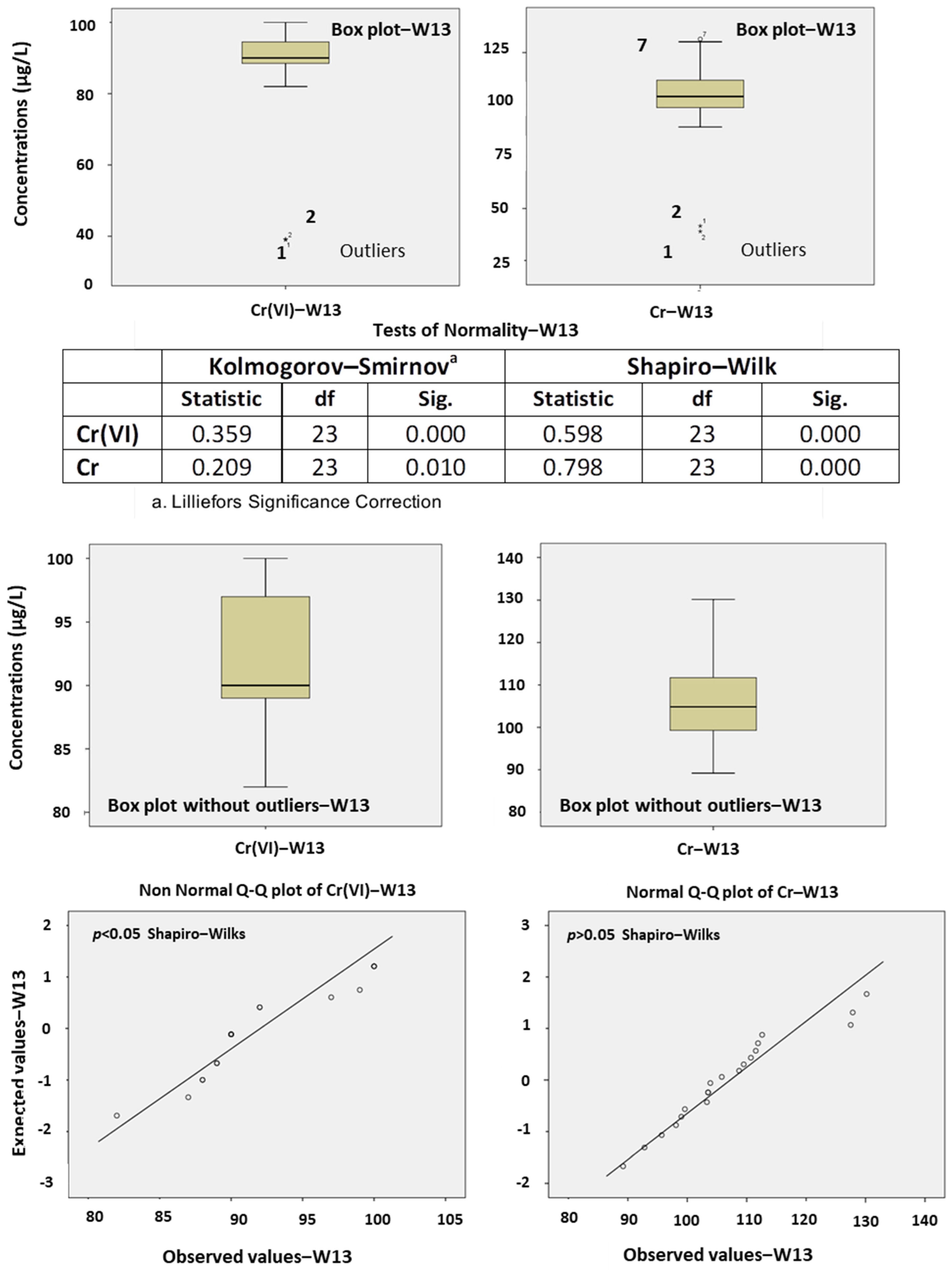
The normality test of Shapiro–Wilks showed that there was no normally distributed population of the samples, either for Cr or Cr(VI) (
p < 0.05). The outliers were identified via Box plots to exclude these measurements in the next step until the total elimination of the outliers, and then the population of the remaining data was rechecked for its normal distribution (
Figure 20 and
Figure 21). The last datasets of each parameter without outliers were double-checked for their normality with Q–Q plots and the Shapiro–Wilks test. In the spring “Elafakia”‒W14, the NBLs of Cr constitutes the 95th percentile (57.24 μg/L) of the population as it was not normally distributed (
Figure 20) [
9]. On the other hand, Cr(VI) dataset was normally distributed, and based on the methodology, the NBL was defined to be 51.20 μg/L (NBL = the maximum value of the normally distributed dataset). Similarly, in the spring “Potistis”‒W13, the NBLs of Cr is equal to the max value (130 μg/L) of the normally distributed dataset while the NBL for Cr(VI) was calculated at 100 μg/L (NBL = the 95th percentile of the dataset as non-normally distributed) (
Figure 21).
The estimated NBL is higher than the REF value (NBL/REF > 1) for both natural springs of Vermio. According to this suggestion, the TVs are determined as NBL for Cr in the natural springs of “Elafakia”‒W14 and “Potistis”‒W13. The spring “Potistis”‒W13 is considered to be the most suitable one to define the NBLs in the ultramafic environment of western Vermio Mt., because its water type (Mg-Ca-HCO
3) indicated a strong influence by ultramafic rocks, whereas the spring “Elafakia”‒W14, with a Ca-Mg-HCO
3 water type, was mainly influenced by carbonate formations. In
Figure 22, the flow chart describes the NBLs and TVs assessment for Cr and Cr(VI), for the natural spring “Potistis”‒W13.
The assessment of NBLs in ultramafic springs is a challenging modern methodology based on the continuous monitoring of hydrochemical parameters. Nevertheless, it is essential to mention that, since the environmental systems are complex and multicomponent, NBLs should not be treated as the absolute value above which a parameter is of anthropogenic origin; instead, NBLs constitute the minimum target value and the guide for investigating elevated groundwater concentrations of a hydrogeochemical parameter and elucidating the influence of anthropogenic factors in a study area on a larger scale (e.g., at a catchment scale). The continued monitoring of water quality parameters is likely to provide higher concentrations of the specific parameters in the future, and therefore subsequent recalculation of NBLs may lead to higher NBLs in the study area.
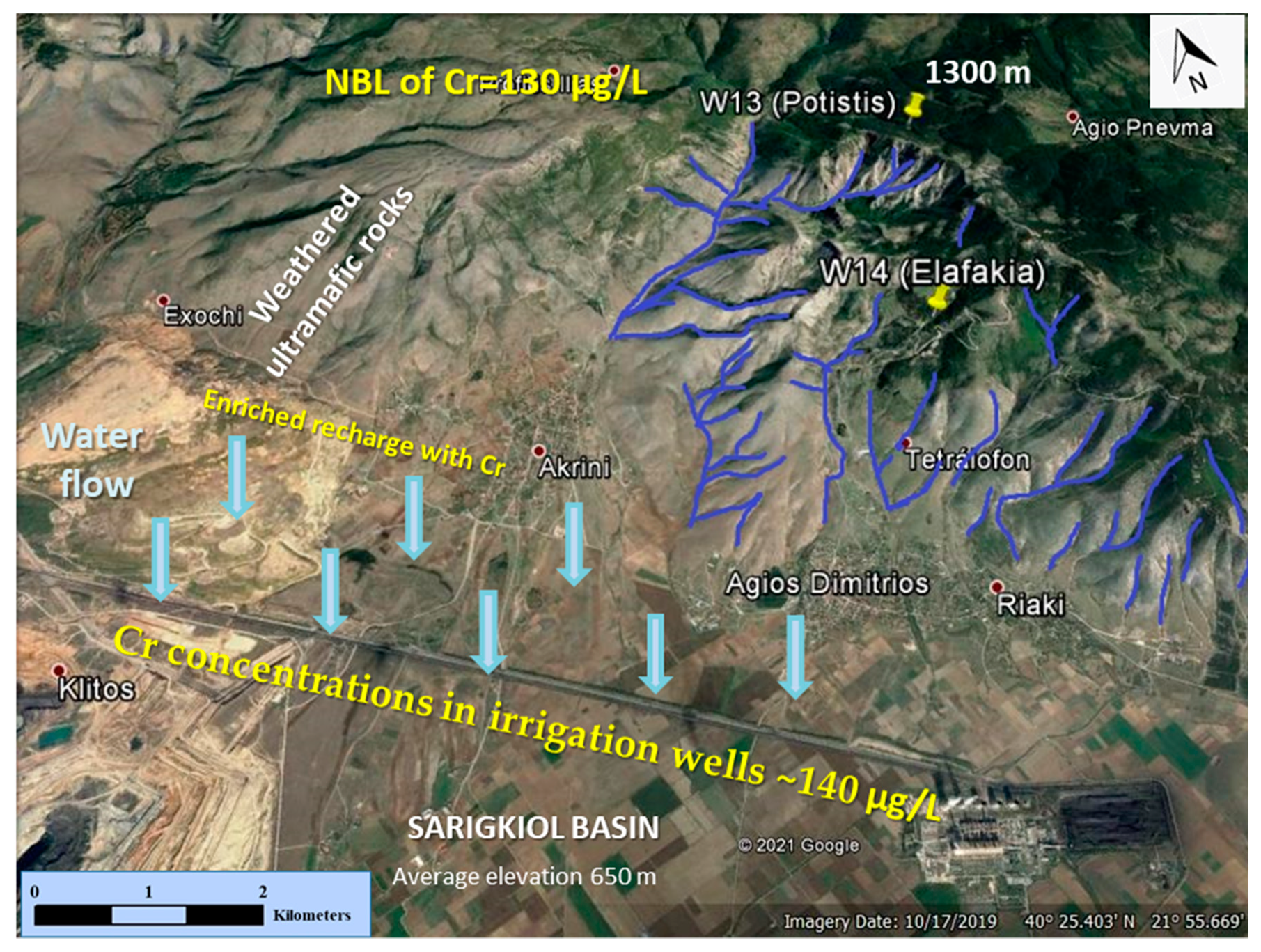
The high potential leaching of Cr in Vermio Mt., as derived from the above-mentioned calculated NBLs, is imprinted in the lowland of the Sarigkiol Basin [
45]. The surface runoff and the discharge of springs enriched in Cr follow various flow paths via torrents or streams through the weathered mantle of ultramafic rocks in western Vermio Mt. and leach into the lowland of the Sarigkiol Basin (
Figure 23). Due to the hydraulic connection between the western Vermio Mt. and the eastern part of the lowland of the Sarigkiol Basin, the defined NBLs apply to the latter, supporting the dominance of the geogenic factor in the high groundwater concentration of Cr in the Sarigkiol Basin.
5. Conclusions
The ultramafic-dominated environment of western Vermio Mt. was fingerprinted on the groundwater chemistry and specifically on the elevated concentrations of Mg2+, Si, Ni, and Cr in natural spring waters. Chromium was recognized as the principal environmental parameter in the natural spring waters of western Vermio Mt; in 42% of the studied spring water samples, the concentrations of Cr exceeded the WHO guideline value of 50 μg/L for drinking water. The geogenic origin of Cr in groundwater is recorded in the very strong positive correlation coefficients of Cr with Si, the strong positive correlation coefficients with Mg2+, EC, and Ni, and the moderate positive correlation coefficients with HCO3 and alkalinity.
The main factors that determined the concentration of Cr in the studied spring waters were:
- (a)
the time response of the aquifers systems to precipitations; direct infiltration on the geological formation of the aquifer results in immediate recharge of it. As a consequence, quick contaminant dilution takes place and fluctuations in Cr concentrations are observed depending on the time response of the aquifers to precipitation,
- (b)
the water–rock contact time; the longer the water–rock contact time is, the higher the Cr leaching is,
- (c)
the flow path of groundwater; a flow path through weathered ultramafic rocks results in the enrichment of groundwater in Cr,
- (d)
the degree of the serpentinisation of ultramafic rocks; the more serpentinised the ultramafic rocks are, the higher their leaching potential in Cr is, and
- (e)
the prevailing geochemical processes that favor the oxidation of Cr(III) to the soluble and mobile Cr(VI), such as alkaline pH, oxidative environment, presence of manganese oxides.
The absence of anthropic/anthropogenic activities in western Vermio Mt., the sufficient time-series data, and the hydrochemical characteristics of the studied springs allowed the assessment of NBLs of Cr by applying a multi-method approach. Considering the hydrogeological, hydrochemical, and hydrological data in western Vermio Mt. and applying the PS method, the spring “Potistis”‒W13 was selected as the most representative one to define the NBLs of Cr in the area. The applied methodology is fully harmonized with the GDD and the Water Framework Directive (WFD, 2000/60/EC) [
81]. The NBL of Cr was defined at 130 μg/L, and that of Cr(VI) at 100 μg/L. Based on the NBLs of Cr, TVs for Cr at a catchment scale, i.e., the Sarigkiol Basin, were defined to be equal to the NBLs. Conclusively, the ultramafic environment in western Vermio Mt. presents a high geochemical potential to dissolve and mobilize geogenic Cr.
This first systematic study of the natural springs of western Vermio Mt. provides important hydrogeochemical data for the geogenic footprint of a natural ultramafic environment on the groundwater quality. The proposed methodology could be implemented in any catchment scale aiming to distinguish between geogenic and anthropogenic groundwater deterioration and to establish new TVs considering the NBLs.


