
Integrated Assessment of Groundwater Potential Using Geospatial Techniques in Southern Africa: A Case Study in the Zambezi River Basin


Abstract
1. Introduction
2. Materials and Methods
2.1. The Study Area
2.2. Biophysical Data
2.3. Methodological Approach
2.4. Preparation of Thematic Data
2.5. Multi-Criteria Decision Making Methods
2.6. Assignment of Weights to Individual Thematic Layers
2.7. Validation of Groundwater Potential Zones
3. Results
- Aquifers, where groundwater flow is mostly through fractures, fissures and/or discontinuities, are categorised as highly productive. Highly productive aquifers occur mostly in karstic limestones/marbles on the Copperbelt and stretching down into the Lusaka area;
- Aquifers, where intergranular groundwater flow is dominant, occur mostly in alluvial soils and Tertiary sand deposits;
- Low-yielding weathered and/or fractured aquifers with limited potential are largely found in the Basement complex, and some in igneous rocks.
3.1. Lithology
3.2. Drainage Density
3.3. Lineament Density
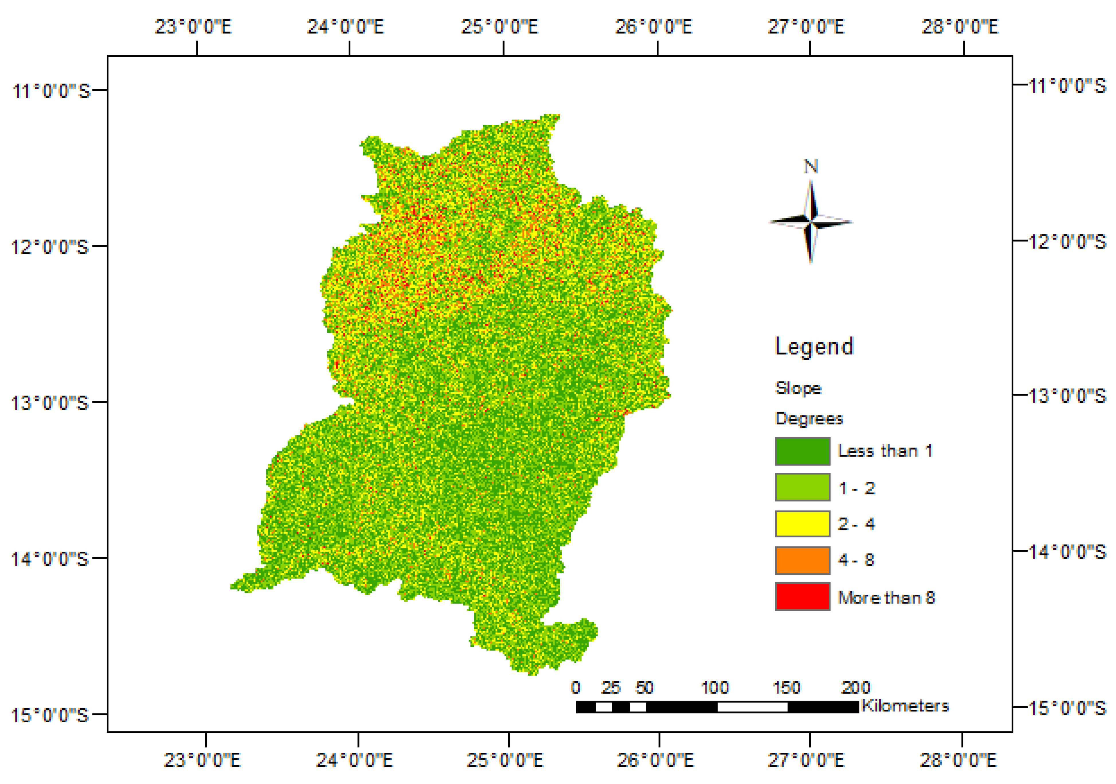
3.4. Slope
3.5. Soils
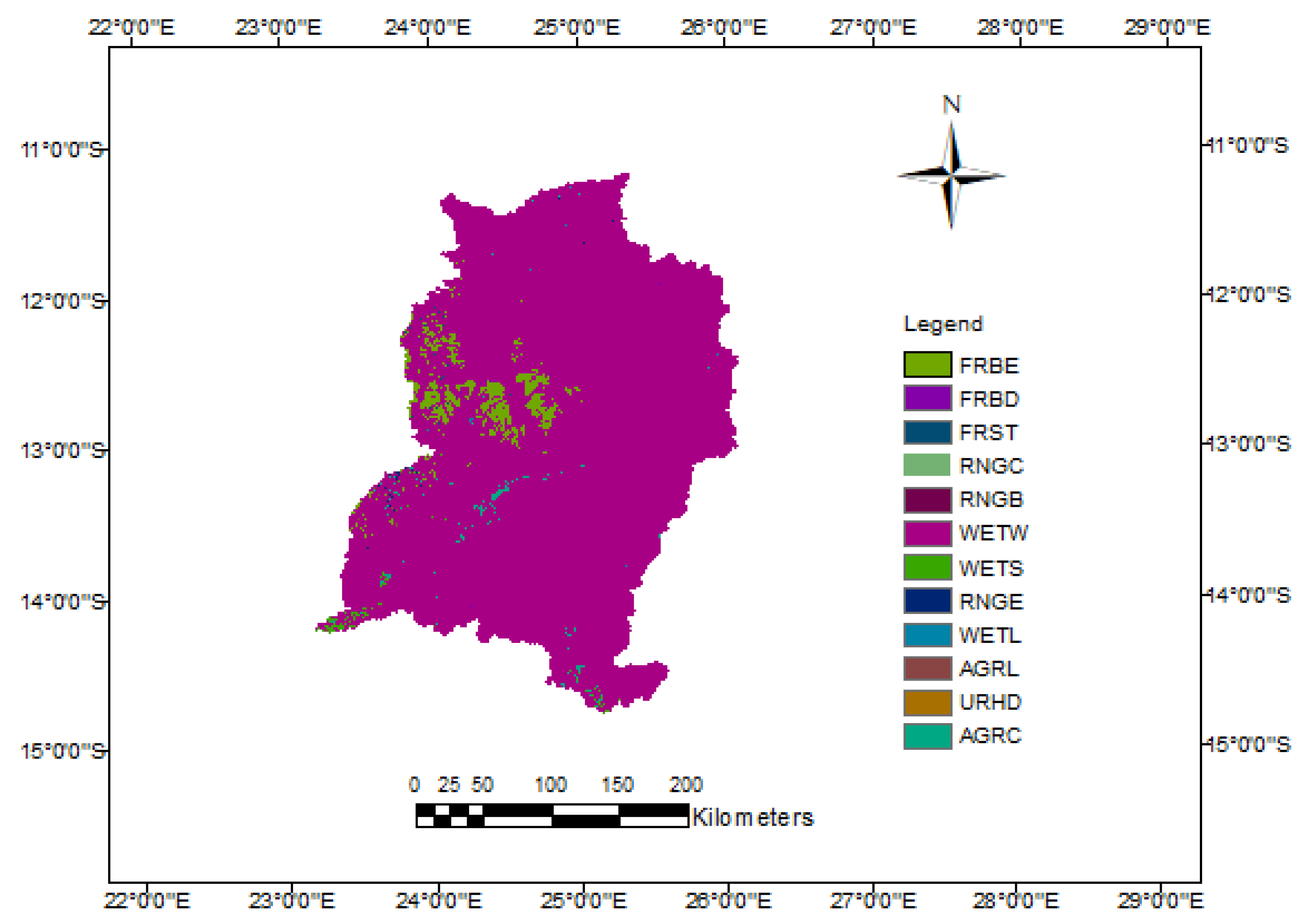
3.6. Land Use/Land Cover
3.7. Precipitation
3.8. Ranking of Influencing Factors Using Analytical Hierarchy Process
3.9. Weighted Overlay Operation
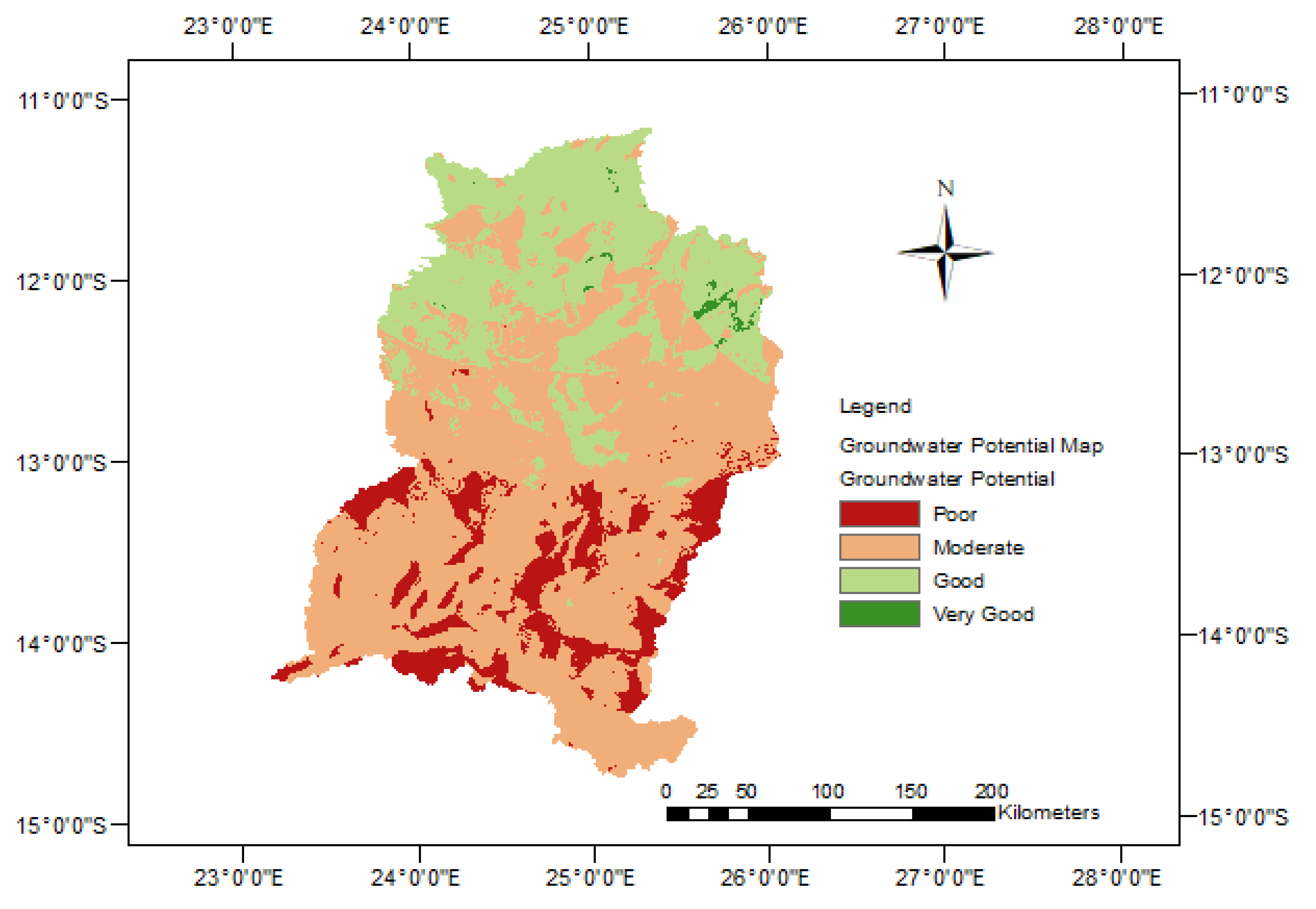
3.10. Validation of the Groundwater Potential Map
4. Discussion
5. Conclusions
Author Contributions
Funding
Acknowledgments
Conflicts of Interest
References
- Tolche, A.D. Groundwater potential mapping using geospatial techniques: A case study of Dhungeta-Ramis sub-basin, Ethiopia. Geol. Ecol. Landscapes 2020, 5, 65–80. [Google Scholar] [CrossRef]
- Arnell, N.W.; Halliday, S.J.; Battarbee, R.W.; Skeffington, R.A.; Wade, A.J.; Fung, F.; Orr, H.G.; Charlton, M.B. The implications of climate change for the water environment in England. Prog. Phys. Geogr. Earth Environ. 2015, 39, 93–120. [Google Scholar] [CrossRef]
- Kusangaya, S.; Warburton, M.L.; van Garderen, E.A.; Jewitt, G. Impacts of climate change on water resources in southern Africa: A review. Phys. Chem. Earth, Parts A/B/C 2014, 67–69, 47–54. [Google Scholar] [CrossRef]
- Chien, H.; Yeh, P.J.-F.; Knouft, J.H. Modeling the potential impacts of climate change on streamflow in agricultural watersheds of the Midwestern United States. J. Hydrol. 2013, 491, 73–88. [Google Scholar] [CrossRef]
- Naomi Carrard, Tim Foster and Juliet Willetts Groundwater as a Source of Drinking Water in Southeast Asia and the Pacific: A Multi-Country Review of Current Reliance and Resource Concerns. Water 2019, 11, 1605. [CrossRef]
- Hosseinifard, S.J.; Aminiyan, M.M. Hydrochemical Characterization of Groundwater Quality for Drinking and Agricultural Purposes: A Case Study in Rafsanjan Plain, Iran. Water Qual. Expo. Heal. 2015, 7, 531–544. [Google Scholar] [CrossRef]
- Ghosh, P.K.; Bandyopadhyay, S.; Jana, N.C. Mapping of groundwater potential zones in hard rock terrain using geoinformatics: A case of Kumari watershed in western part of West Bengal. Model. Earth Syst. Environ. 2015, 2, 1. [Google Scholar] [CrossRef]
- Waikar, M.L.; Nilawar, A.P. Identification of Groundwater Potential Zone Using Remote Sensing and GIS Technique. IJIRSET 2015, 3, 12163–12174. [Google Scholar]
- Kumar, R.; Dwivedi, S.B.; Gaur, S. A comparative study of machine learning and Fuzzy-AHP technique to groundwater potential mapping in the data-scarce region. Comput. Geosci. 2021, 155, 104855. [Google Scholar] [CrossRef]
- Mallick, J.; Khan, R.A.; Ahmed, M.; Alqadhi, S.D.; Alsubih, M.; Falqi, I.; Hasan, M.A. Modeling Groundwater Potential Zone in a Semi-Arid Region of Aseer Using Fuzzy-AHP and Geoinformation Techniques. Water 2019, 11, 2656. [Google Scholar] [CrossRef]
- Owolabi, S.T.; Madi, K.; Kalumba, A.M.; Orimoloye, I.R. A groundwater potential zone mapping approach for semi-arid environments using remote sensing (RS), geographic information system (GIS), and analytical hierarchical process (AHP) techniques: A case study of Buffalo catchment, Eastern Cape, South Africa. Arab. J. Geosci. 2020, 13, 1184. [Google Scholar] [CrossRef]
- Murmu, P.; Kumar, M.; Lal, D.; Sonker, I.; Singh, S.K. Delineation of groundwater potential zones using geospatial techniques and analytical hierarchy process in Dumka district, Jharkhand, India. Groundw. Sustain. Dev. 2019, 9, 100239. [Google Scholar] [CrossRef]
- Hussein, A.-A.; Govindu, V.; Nigusse, A.G.M. Evaluation of groundwater potential using geospatial techniques. Appl. Water Sci. 2016, 7, 2447–2461. [Google Scholar] [CrossRef]
- Arulbalaji, P.; Padmalal, D.; Sreelash, K. GIS and AHP Techniques Based Delineation of Groundwater Potential Zones: A case study from Southern Western Ghats, India. Sci. Rep. 2019, 9, 2082. [Google Scholar] [CrossRef] [PubMed]
- Song, Y.; Thatcher, D.; Li, Q.; McHugh, T.; Wu, P. Developing sustainable road infrastructure performance in-dicators using a model-driven fuzzy spatial multi-criteria decision making method. Renew. Sustain. Energy Rev. 2021, 138, 110538. [Google Scholar] [CrossRef]
- Costache, R.; Pham, Q.B.; Sharifi, E.; Linh, N.T.T.; Abba, S.I.; Vojtek, M.; Vojteková, J.; Nhi, P.T.T.; Khoi, D.N. Flash-flood suscepti-bility assessment using multi-criteria decision making and machine learning supported by remote sensing and GIS techniques. Remote Sens. 2020, 12, 106. [Google Scholar] [CrossRef]
- Winsemius, H.C.; Savenije, H.H.G.; Gerrits, A.M.J.; Zapreeva, E.A.; Klees, R. Comparison of Two Model Ap-proaches in the Zambezi River Basin with Regard to Model Reliability and Identifiability. Hydrol. Earth Syst. Sci. Discuss. 2005, 2, 2625–2661. [Google Scholar] [CrossRef]
- Hughes, D. Comparison of satellite rainfall data with observations from gauging station networks. J. Hydrol. 2006, 327, 399–410. [Google Scholar] [CrossRef]
- Hamududu, B.H. Impacts of Climate Change on Water Resources and Hydropower Systems in Central and Southern Africa; Norwegian University of Science and Technology: Trondheim, Norway, 2012; Available online: http://hdl.handle.net/11250/242354 (accessed on 12 August 2021).
- Ndhlovu, G.; Woyessa, Y. Modelling impact of climate change on catchment water balance, Kabompo River in Zambezi River Basin. J. Hydrol. Reg. Stud. 2019, 27, 100650. [Google Scholar] [CrossRef]
- Ndhlovu, G.; Woyessa, Y. Use of gridded climate data for hydrological modelling in the Zambezi River Basin, Southern Africa. J. Hydrol. 2021, 602, 126749. [Google Scholar] [CrossRef]
- Beilfuss, R. A Risky Climate for Southern African Hydro. International Rivers, Berkely, 2012, no. September: 1–46. Available online: http://climenews.com/letoltes/zambezi_climate_report_final.pdf (accessed on 18 February 2020).
- Zeng, H.; Wu, B.; Zhang, N.; Tian, F.; Phiri, E.; Musakwa, W.; Zhang, M.; Zhu, L.; Mashonjowa, E. Spatiotemporal Analysis of Precipitation in the Sparsely Gauged Zambezi River Ba-sin Using Remote Sensing and Google Earth Engine. Remote Sens. 2019, 11, 2977. [Google Scholar] [CrossRef]
- Yamba, F.D.; Walimwipi, H.; Jain, S.; Zhou, P.; Cuamba, B.; Mzezewa, C. Climate change/variability implications on hydroelectricity generation in the Zambezi River Basin. Mitig. Adapt. Strat. Glob. Chang. 2011, 16, 617–628. [Google Scholar] [CrossRef]
- Friedl, M.; Sulla-Menashe, D. MCD12Q1 MODIS/Terra+Aqua Land Cover Type Yearly L3 Global 500m SIN Grid V006 [Data set]. NASA EOSDIS Land Processes DAAC. Available online: https://lpdaac.usgs.gov/products/mcd12q1v006/ (accessed on 12 August 2019). [CrossRef]
- Pérez-Lapeña, B.; Saimone, F.; Juízo, D. Mapping groundwater availability and adequacy in the Lower Zambezi River basin. Proc. Int. Assoc. Hydrol. Sci. 2018, 378, 37–42. [Google Scholar] [CrossRef][Green Version]
- Euroconsult Mott Macdonald. Rapid Assessment—Final Report Integrated Water Resources Management pre-sented to Southern African Development Community (SADC), Lusaka. 2007. Available online: http://zambezicommission.org/sites/default/files/publication_downloads/rapid-assessment.pdf (accessed on 10 August 2020).
- Andualem, T.G.; Demeke, G.G. Groundwater potential assessment using GIS and remote sensing: A case study of Guna tana landscape, upper blue Nile Basin, Ethiopia. J. Hydrol. Reg. Stud. 2019, 24, 100610. [Google Scholar] [CrossRef]
- Jha, M.K.; Chowdary, V.M.; Chowdhury, A. Groundwater assessment in Salboni Block, West Bengal (India) using remote sensing, geographical information system and multi-criteria decision analysis techniques. Hydrogeol. J. 2010, 18, 1713–1728. [Google Scholar] [CrossRef]
- Saaty, T.L. How to make a decision: The analytic hierarchy process. Eur. J. Oper. Res. 1990, 48, 9–26. Available online: https://www.sciencedirect.com/science/article/pii/037722179090057I (accessed on 30 April 2020). [CrossRef]
- Basavarajappa, H.T.; Dinakar, S.; Manjunatha, M.C. Validation of Derived Groundwater Potential Zones (Gwpz) Using Geoinformatics and Actual Yield From Well Points in Parts of Upper Cauvery Basin of Mysuru and Chamarajanagara Districts, Karntaka, India. Int. J. Civ. Eng. Technol. (IJCIET) 2016, 7, 141–161. Available online: http://www.iaeme.com/IJCIET/issues.asp?JType=IJCIET&VType=7&IType=1 (accessed on 12 August 2021).
- Ojo, J.S.; Olorunfemi, M.O.; Akintorinwa, O.J.; Bayode, S.; Omosuyi, G.O.; Akinluyi, F.O. GIS Integrated Geomorphological, Geological and Geoelectrical Assessment of the Groundwater Potential of Akure Metropolis, Southwest Nigeria. J. Earth Sci. Geotech.Eng. 2015, 5, 85–101, ISSN: 1792-9040 (print), 1792–9660 (online). Available online: https://www.researchgate.net/publication/288060491 (accessed on 12 August 2021).
- Rukundo, E.; Doğan, A. Dominant Influencing Factors of Groundwater Recharge Spatial Patterns in Ergene River Catchment, Turkey. Water 2019, 11, 653. [Google Scholar] [CrossRef]
- Earle, S. Physical Geology, 2nd ed.; BCcampus: Victoria, BC, Canada, 2019; Available online: https://opentextbc.ca/physicalgeology2ed/ (accessed on 12 August 2021).
- Yeh, H.-F.; Cheng, Y.-S.; Lin, H.-I.; Lee, C.-H. Mapping groundwater recharge potential zone using a GIS approach in Hualian River, Taiwan. Sustain. Environ. Res. 2016, 26, 33–43. [Google Scholar] [CrossRef]
- U.S. Army Corps of Engineers. Washington, DC 20314-1000, Engineering and Design, Groundwater Hydrology. Manual No. 1110-2-1421. 1999. Available online: https://www.samsamwater.com/library/Groundwater_Hydrology.pdf (accessed on 10 September 2021).
- Atangana, A. Fractional Operators with Constant and Variable Order with Application to Geo-Hydrology; Elsevier: Amsterdam, The Netherlands, 2018. [Google Scholar] [CrossRef]
- JICA & MEWD. JICA 1995 Final Report Water Resources Master Plan-Zambia.Pdf. 1995. Available online: https://openjicareport.jica.go.jp/pdf/11251659_01.pdf (accessed on 23 January 2020).
- Bäumle, R.; Himmelsbach, T.; Noell, U. Hydrogeology and geochemistry of a tectonically controlled, deep-seated and semi-fossil aquifer in the Zambezi Region (Namibia). Hydrogeol. J. 2018, 27, 885–914. [Google Scholar] [CrossRef]
- Prasad, R.K.; Mondal, N.; Banerjee, P.; Nandakumar, M.V.; Singh, V.S. Deciphering potential groundwater zone in hard rock through the application of GIS. Environ. Earth Sci. 2007, 55, 467–475. [Google Scholar] [CrossRef]
- Chikambwe, E.M. GIS-Based Predictive Mapping for Aquamarine-Bearing Pegmatites, Lundazi Area, Northeast Zambia. 2002. International Institute For Geo-Information Science and Earth Observation, University of Twenty, Enschede, The Netherlands. Available online: https://webapps.itc.utwente.nl/librarywww/papers/msc_2002/ereg/chikambwe.pdf (accessed on 30 April 2021).
- Magesh, N.; Chandrasekar, N.; Soundranayagam, J.P. Delineation of groundwater potential zones in Theni district, Tamil Nadu, using remote sensing, GIS and MIF techniques. Geosci. Front. 2012, 3, 189–196. [Google Scholar] [CrossRef]
- Greenbaum, D. Review of Remote Sensing Applications to Groundwater Exploration in Basement and Regolith; British Geological Survey: Nottingham, UK, 1985; 63p, (WC/OG/85/001). [Google Scholar]
- Saaty, T.L.; Vargas, L.G. The Analytic Hierarchy Process: Planning and Risk. 1991, An overview of the analytic hierarchy process and its applications. Eur. J. Oper. Res. 1990, 48, 11–32. [Google Scholar] [CrossRef]
- Karayalcin, I. The analytic hierarchy process: Planning, priority setting, resource allocation: Thomas L. SAATY McGraw-Hill, New York, 1980, xiii + 287 pages. Eur. J. Oper. Res. 1982, 9, 97–98. [Google Scholar] [CrossRef]
- Rejith, R.G.; Anirudhan, S.; Sundararajan, M. Chapter 25—Delineation of Groundwater Potential Zones in Hard Rock Terrain Using Integrated Remote Sensing, GIS and MCDM Techniques: A Case Study From Vamanapuram River Basin, Kerala, India; Venkatramanan, S., Prasanna, M.V., Chung, S.Y., Eds.; GIS and Geostatistical Techniques for Groundwater Science; Elsevier: Amsterdam, The Netherlands, 2019; pp. 349–364. ISBN 9780128154137. Available online: https://www.sciencedirect.com/science/article/pii/B9780128154137000250 (accessed on 30 April 2021). [CrossRef]
- Malczewski, J. GIS and Multicriteria Decision Analysis; J. Wiley & Sons: New York, NY, USA, 1999; Available online: http://books.google.com/books?id=oJ8sAQAAMAAJ (accessed on 30 April 2021).
- Nkhuwa, D.C.W.; Kang’omba, S.; Chomba, K.C.; Crane, E.; Upton, K.; Ó Dochartaigh, B.É.; Bellwood-Howard, I. Africa Groundwater Atlas: Hydrogeology of Zambia. British Geological Survey. Accessed [date you accessed the information]. 2018. Available online: http://earthwise.bgs.ac.uk/index.php/Hydrogeology_of_Zambia (accessed on 19 August 2021).


| Importance | Definition | Description |
|---|---|---|
| 1 | Equal Importance | Two elements contribute equally to the objective |
| 3 | Moderate importance | Experience and judgement slightly favour one element over another |
| 5 | Strong Importance | Experience and judgement strongly favour one element over another |
| 7 | Very strong importance | One element is favoured very strongly over another, its dominance is demonstrated in practice |
| 9 | Extreme importance | The evidence favouring one element over the other is of the highest possible order or affirmation |
| Factors | Rainfall | Lithology | Lineament Density | LULC | Drainage Density | Soil | Slope | Normalized Weight (%) |
|---|---|---|---|---|---|---|---|---|
| Rainfall | 1 | 3 | 3 | 5 | 5 | 5 | 7 | 37 |
| Lithology | 0.33 | 1 | 3 | 3 | 5 | 5 | 7 | 24 |
| Lineament density | 0.33 | 0.33 | 1 | 3 | 3 | 5 | 5 | 16 |
| LULC | 0.2 | 0.33 | 0.33 | 1 | 3 | 3 | 5 | 10 |
| Drainage density | 0.2 | 0.2 | 0.33 | 0.33 | 1 | 3 | 3 | 6 |
| Soil | 0.2 | 0.2 | 0.2 | 0.33 | 0.33 | 1 | 3 | 4 |
| Slope | 0.14 | 0.14 | 0.2 | 0.2 | 0.33 | 0.33 | 1 | 3 |
| Total | 2.4 | 5.2 | 8.06 | 12.86 | 17.66 | 22.33 | 31 | 100 |
| Parameter | Class | Groundwater Potential | Ranking | Normalised Weight (%) |
|---|---|---|---|---|
| Precipitation | (mm/year) | 37 | ||
| 1150–1250 | Very Good | 5 | ||
| 1050–1150 | Good | 4 | ||
| 1000–1050 | Moderate | 3 | ||
| 950–1000 | Poor | 2 | ||
| 900–950 | Very Poor | 1 | ||
| Lithology | Lithological Unit | 24 | ||
| Alluv colluv laterit | Very Good | 5 | ||
| Basal conglomerate | Very Good | 5 | ||
| Basalts | Very Good | 5 | ||
| Carbonate rocks | Good | 4 | ||
| Dolomite & argilli | Good | 4 | ||
| Fossil sief dunes | Good | 4 | ||
| Meta-carbonate rocks | Good | 4 | ||
| Meta-quartzites | Moderate | 3 | ||
| Mine Series undiff | Moderate | 3 | ||
| Syenite syenodiorite | Moderate | 3 | ||
| Upp Karoo undiff | Poor | 2 | ||
| psammite rudite form | Poor | 2 | ||
| shale silt sandstone | Poor | 2 | ||
| Undiff granite gneiss | Very poor | 1 | ||
| Undiff schists | Very Poor | 1 | ||
| Grainite | Very Poor | 1 | ||
| Igneous meta-igneous | Very Poor | 1 | ||
| Lineament density | Km/Km2 | 16 | ||
| 0.18–0.22 | Very Good | 5 | ||
| 0.13–0.18 | Good | 4 | ||
| 0.09–0.13 | Moderate | 3 | ||
| 0.04–0.09 | Poor | 2 | ||
| 0.00–0.04 | Very Poor | 1 | ||
| Land use/Land cover | Wetlands-Mixed | Very Good | 5 | 10 |
| Agriculture Land-Close grown | Good | 4 | ||
| Agricultural Land-Generic | Good | 4 | ||
| Range-Grasses | Moderate | 3 | ||
| Savannahs | Moderate | 3 | ||
| Woody Savannahs | Moderate | 3 | ||
| Closed Shrub-lands | Moderate | 3 | ||
| Evergreen Broadleaf Forest | Moderate | 3 | ||
| Range Brush | Poor | 2 | ||
| Forest-Mixed | Poor | 2 | ||
| Deciduous Broadleaf Forest | Poor | 2 | ||
| Urban and Built-Up | Very poor | 1 | ||
| Drainage density | km/km2 | 6 | ||
| 0–3 | Very Good | 5 | ||
| 3–7 | Good | 4 | ||
| 7–11 | Moderate | 3 | ||
| 11–15 | Poor | 2 | ||
| 15–18 | Very Poor | 1 | ||
| Soil | Soil Texture | 4 | ||
| Loose sandy soils | Very Good | 5 | ||
| Loose sandy soils | Very Good | 5 | ||
| Fine loamy soils | Good | 4 | ||
| Fine loamy soils | Good | 4 | ||
| Gravelly clayey soils | Moderate | 3 | ||
| Fine loamy to clayey soils | Poor | 2 | ||
| Fine loamy to clayey soils | Poor | 2 | ||
| Clayey soils with a high silt/ clay ratio | Very Poor | 1 | ||
| Slope | Degrees | 3 | ||
| 0–1° | Very Good | 5 | ||
| 1–2° | Good | 4 | ||
| 2–4° | Moderate | 3 | ||
| 4–8° | Poor | 2 | ||
| 8–52° | Very Poor | 1 |
| Groundwater Potential | Number of Pixels | Sub Area km2 | Area (%) | Comments |
|---|---|---|---|---|
| Poor | 5203 | 8639 | 12 | Has low potential for ground water |
| Moderate | 26,476 | 43,961 | 61 | Has sufficient potential for ground water |
| Good | 11,545 | 19,170 | 27 | Has a high potential for ground water |
| Very Good | 191 | 317 | 0.4 | Has a very high potential for ground water |
| Total | 43,415 | 72,087 | 100 |
| Number of Zones | Groundwater Potential Zone | Coverage Area km2 | Number of Existing Boreholes | % of Existing Total Boreholes | % of Boreholes on Suitable Zones |
|---|---|---|---|---|---|
| 1 | Poor | 8639 | 113 | 11 | n/a |
| 2 | Moderate | 43,961 | 666 | 68 | 68 |
| 3 | Good | 19,170 | 143 | 15 | 15 |
| 4 | Very Good | 317 | 58 | 6 | 6 |
| Total | 72,087 | 980 | 100 | 89 |
Publisher’s Note: MDPI stays neutral with regard to jurisdictional claims in published maps and institutional affiliations. |
© 2021 by the authors. Licensee MDPI, Basel, Switzerland. This article is an open access article distributed under the terms and conditions of the Creative Commons Attribution (CC BY) license (https://creativecommons.org/licenses/by/4.0/).
Share and Cite
Ndhlovu, G.Z.; Woyessa, Y.E. Integrated Assessment of Groundwater Potential Using Geospatial Techniques in Southern Africa: A Case Study in the Zambezi River Basin. Water 2021, 13, 2610. https://doi.org/10.3390/w13192610
Ndhlovu GZ, Woyessa YE. Integrated Assessment of Groundwater Potential Using Geospatial Techniques in Southern Africa: A Case Study in the Zambezi River Basin. Water. 2021; 13(19):2610. https://doi.org/10.3390/w13192610
Chicago/Turabian StyleNdhlovu, George Z., and Yali E. Woyessa. 2021. "Integrated Assessment of Groundwater Potential Using Geospatial Techniques in Southern Africa: A Case Study in the Zambezi River Basin" Water 13, no. 19: 2610. https://doi.org/10.3390/w13192610
APA StyleNdhlovu, G. Z., & Woyessa, Y. E. (2021). Integrated Assessment of Groundwater Potential Using Geospatial Techniques in Southern Africa: A Case Study in the Zambezi River Basin. Water, 13(19), 2610. https://doi.org/10.3390/w13192610