1. Introduction
During the Weichselian glaciation (about 110–12 ka ago, the below mentioned Valdai cryochron according to the Russian notation), continental glaciation occurred repeatedly and its characteristics have been studied quite well for the East European Plain [
1,
2,
3,
4,
5,
6,
7,
8,
9,
10,
11,
12,
13,
14,
15,
16,
17,
18,
19,
20,
21,
22,
23,
24,
25,
26].
Geomorphological, textural, pedological, faunistic, micropaleontological, pollen, and geochemical signs indicate that a dry, cold and windy climate of the Arctic steppes with sparse cold-tolerant vegetation was prevalent in the periglacial area [
27,
28,
29,
30,
31,
32,
33,
34,
35]. Cold conditions are marked by the wide distribution of loess, relics of the aeolian dune relief, and the asymmetric structure of river valleys [
36,
37,
38,
39]. In the Valdai cryochron, most of the East European Plain was an area of continuous permafrost. For example, in its central part during the MIS-2 the permafrost was 200–250 m thick, and the ground temperature was about −5 °C [
40]. There are no data on the degree of permafrost degradation within the warm episodes of the Valdai cryochron. However, it can be assumed that the ground ice was not completely melted due to the low vertical hydraulic permeability of the geological section, as aquicludes prevented percolation of the warm recharge water to a significant depth.
After the disappearance of permafrost in the Holocene, the soil-forming processes and chemical weathering were intensified [
41,
42]. The paleocryogenic microrelief was buried and levelling of the earth surface took place due to the soil flow and modern sediment accumulation [
43,
44,
45,
46]. Meltwater formed from the thawed permafrost and ice-wedges (hereafter referred to as a glacial meltwater). In the upper part of the geological section, it should have been replaced by young recharge water with modern and/or Holocene age, but the low permeability of the clayey layers could to preserve the meltwater at depth.
It is clearly known that global climatic variations are reliably recorded using stable isotopes [
47,
48,
49,
50,
51]. Groundwater, which formed during the cold period due to meteoric water recharge, has a depleted (light) isotopic composition of hydrogen and oxygen, i.e., very negative values of δ
18O and δ
2H. Cryogenic metamorphism is also possible during permafrost growth. In the frozen zone, the isotopic composition of ice could be less depleted by deuterium and oxygen-18 relative to the initial recharge water of atmospheric origin. In contrast, the residual water, which is accumulated at the base layer of the permafrost, should be more depleted by
18O and
2H relative to the initial isotope composition [
52]. At the same time, the ice in permafrost (and also glacial meltwater) is desalinated, and the lost salts accumulate in the residual water. This process can lead to the formation of inversion chemical zonation in the depths below the bottom of the former permafrost [
52].
The authors of this work also assume that the glacial meltwater should be marked as an anomaly in the isotopic composition of uranium
234U/
238U > 1 (hereafter in the activity ratio) due to the excess of uranium-234. The mechanism of equilibrium loss may be result of the very different geochemical mobility of parent uranium-238 and daughter uranium-234. Usually,
234U has the oxidation state 6+, which is soluble and could be transported with water in uranyl complexes, but
238U has the oxidation state 4+ and is included in the mineral lattice as non-soluble forms [
53,
54,
55]. Additionally,
234U is located in connection with the recoil tracks of α-particle and
234Th (first daughter isotope to
238U), so the diffusion coefficient of
234U atoms in the mineral lattice is more than it is for
238U atoms by about two orders, as we calculated. As liquid water was non-available during a significant geological time period, such as the Valdai cryochron, uranium-234 generated in minerals as the normal component of the radioactive chain (
234U/
238U = 1). When meltwater from the thawed permafrost appeared, then predominantly
234U would be rapidly leached from the water-bearing sediments and rocks compared to
238U. Therefore, the glacial meltwater (but not the next portions of the recharge water) should be marked by
234U/
238U > 1. For some areas in Russia, which were under periglacial conditions in the last ice age, this hypothetical mechanism received confirmation from a complex study of groundwater, including the determination of δ
18O, δ
2H,
234U/
238U, Noble Gas Temperature calculation and the dating of groundwater by the helium technique [
56,
57,
58,
59]. Thus, the isotopic ratio
234U/
238U can be used to diagnose the presence of glacial meltwater at the present time and to estimate the freezing depth of the geological section during the glacial period.
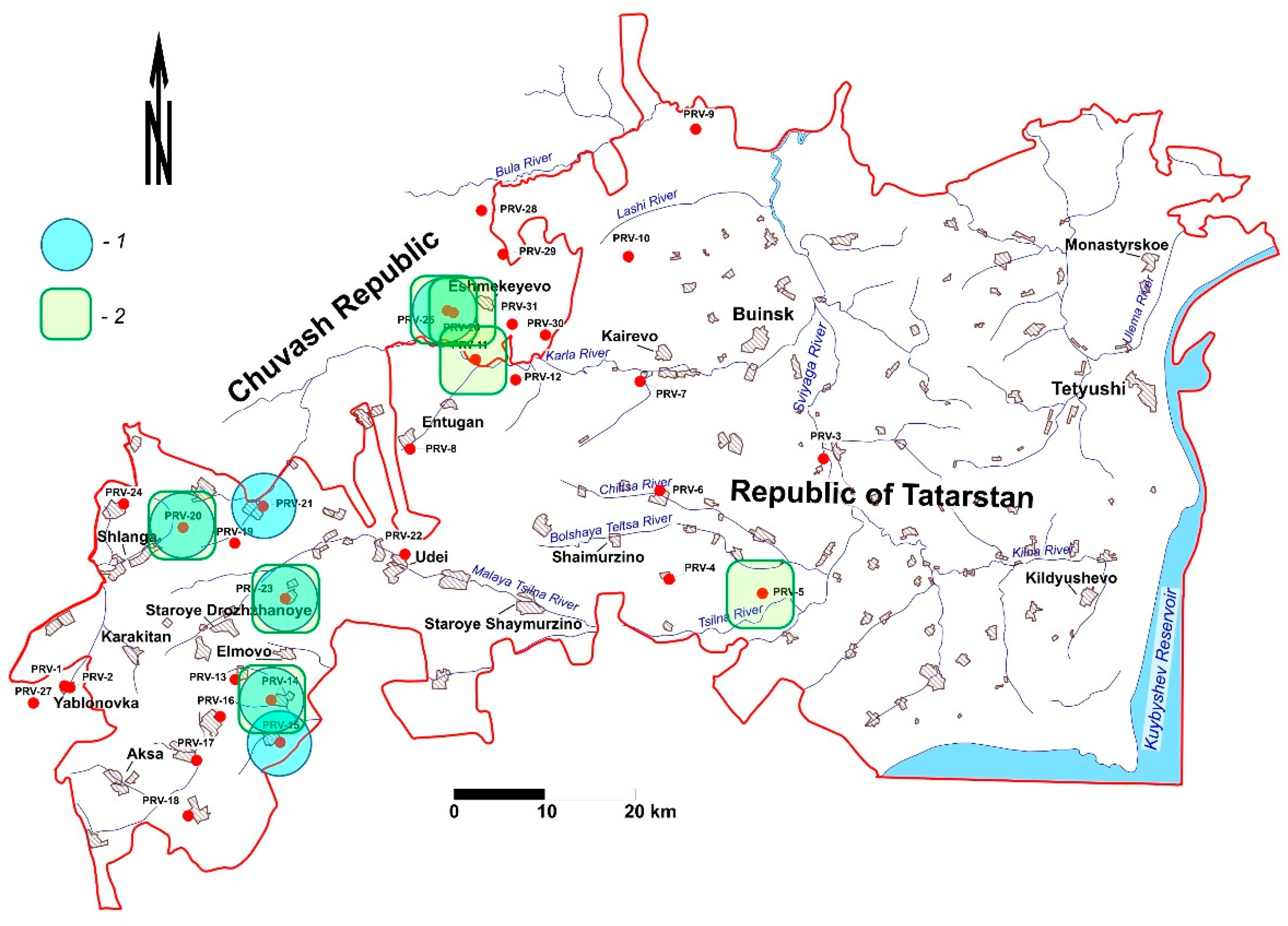
In this work, the Pre-Volga region (right bank of the Volga River along the middle reach) was studied, where groundwater was sampled down to a depth of 400 m for determination of the chemical and isotope composition of the water.
2. Characterization of the Studied Area
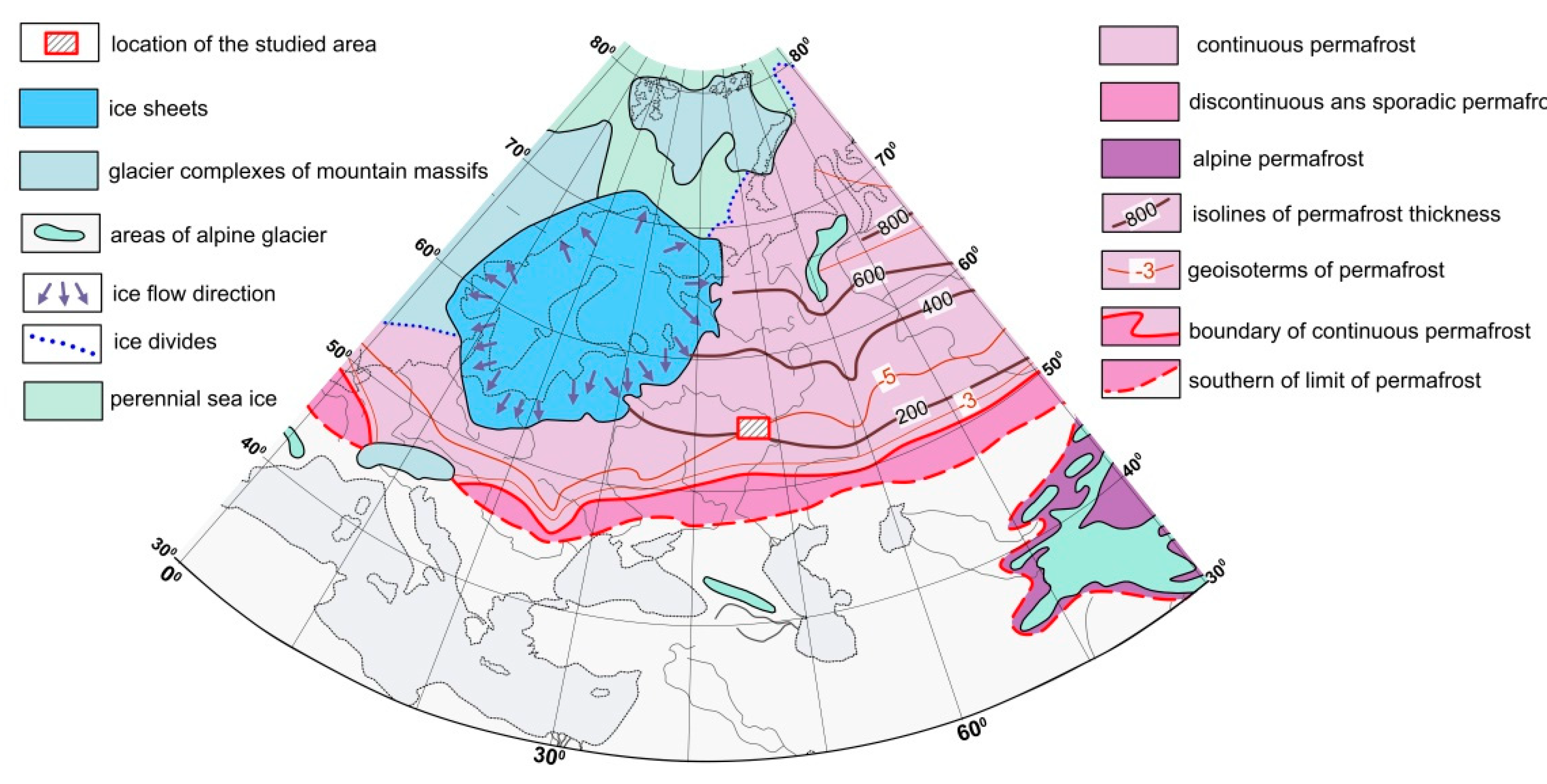
The area is a hilly plain with absolute marks of thalweg of the river valleys down to 40 and watersheds up to 230 m. The main drains are the Sviyaga and the Sura rivers (both are right tributaries of the Volga River). River valleys are usually trough- and U-shaped, while watersheds are plateau-like. Local elevation differences usually do not exceed 80–100 m. The modern climate of the Pre-Volga region is temperate continental with an average annual air temperature of +2.9 °C. The snow cover lasts 120–160 days and the depth of seasonal freezing is 1.8 m. The Yaroslavsky (MIS-2 12.2–20 ka) and Selikhovodvorsky (MIS-4 58–71 ka) cryogenic soils mark the coldest climatic stages of the Valdai cryochron in the study area (
Table 1). There was no ice cover on the Pre-Volga region in this period, and only a small area on the highest watersheds was probably iced [
60]. The boundary of the continuous permafrost was located far to the south of the study area (
Figure 1).
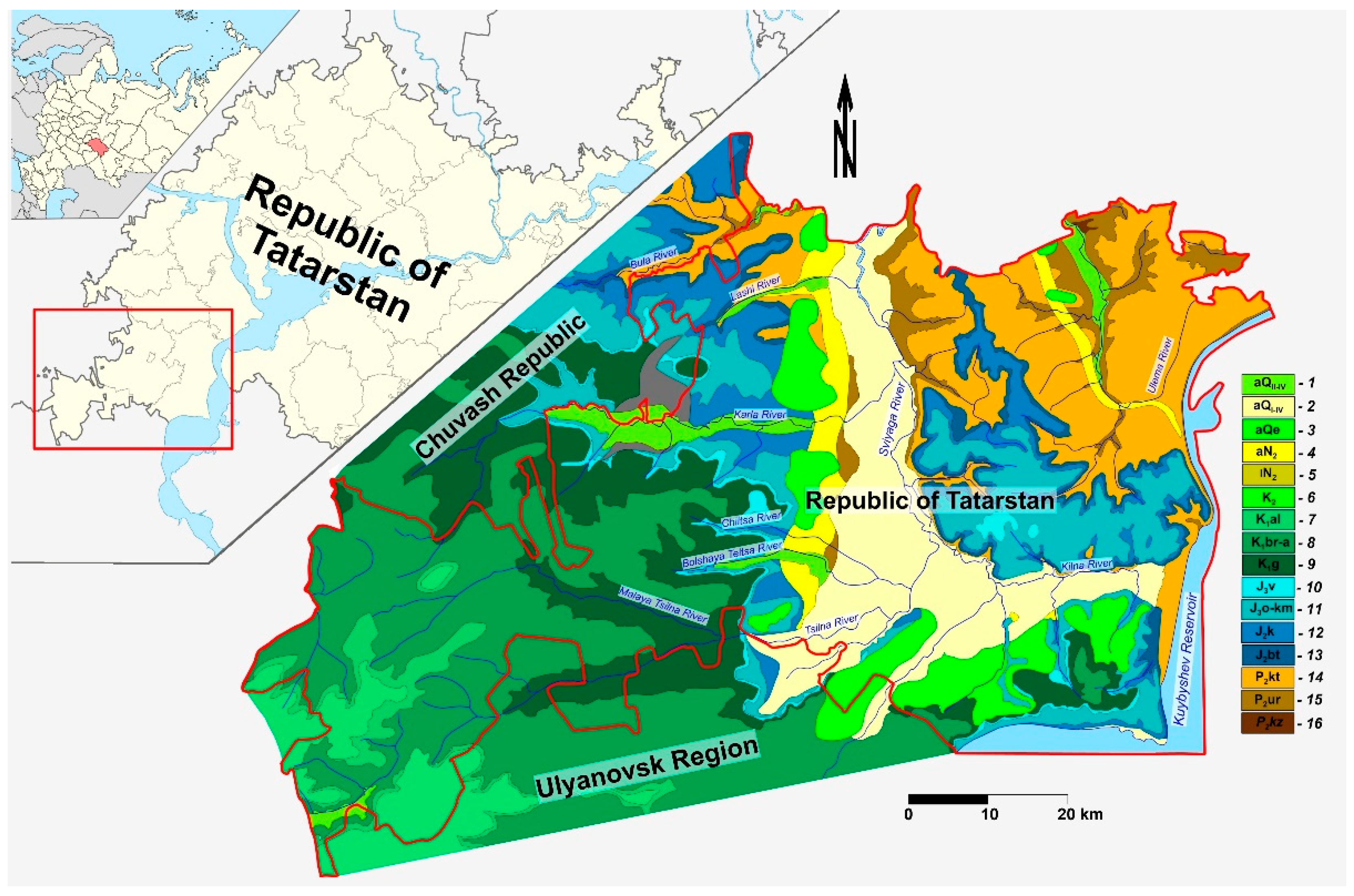
The upper part (400–600 m) of the geological section in the studied area is composed of Paleozoic, Mesozoic and Cenozoic sediments (
Figure 2).
The Paleozoic-Mesozoic strata are represented by interlayering of the terrigenous-carbonate formation (mostly argillites and dolomites) with inclusions of evaporite—anhydrite, gypsum and, rarely, rock salts. The thickness of the Late Cenozoic sediments (the Neogene and the Quaternary) varies from 1 to 35 m, but the buried valleys of the paleo-rivers can sometimes reach a depth of 200 m. Excluding the alluvial sediments in the river valleys, all Quaternary facies have a clayey or loamy composition [
62].
All shallow aquifers (which are first from earth surface) from the alluvium (aQI-IV and N2) to the Urzhum suite (P2ur) have modern recharge, as is clearly seen from the 3H content in most times. The Urzhum suite sediments are dried on the local watersheds. The total volume of freshwater in the phreatic zone of the main catchments is calculated at 11.7 km3. Taking into account the modulus of the minimum winter 30-day river runoff for a year of 95% supply and the calculated volume of freshwater, the residence time of groundwater in the zone of the active water exchange is τ ≈ 200–3000 years, and on average, 1900 years.
3. Materials and Methods
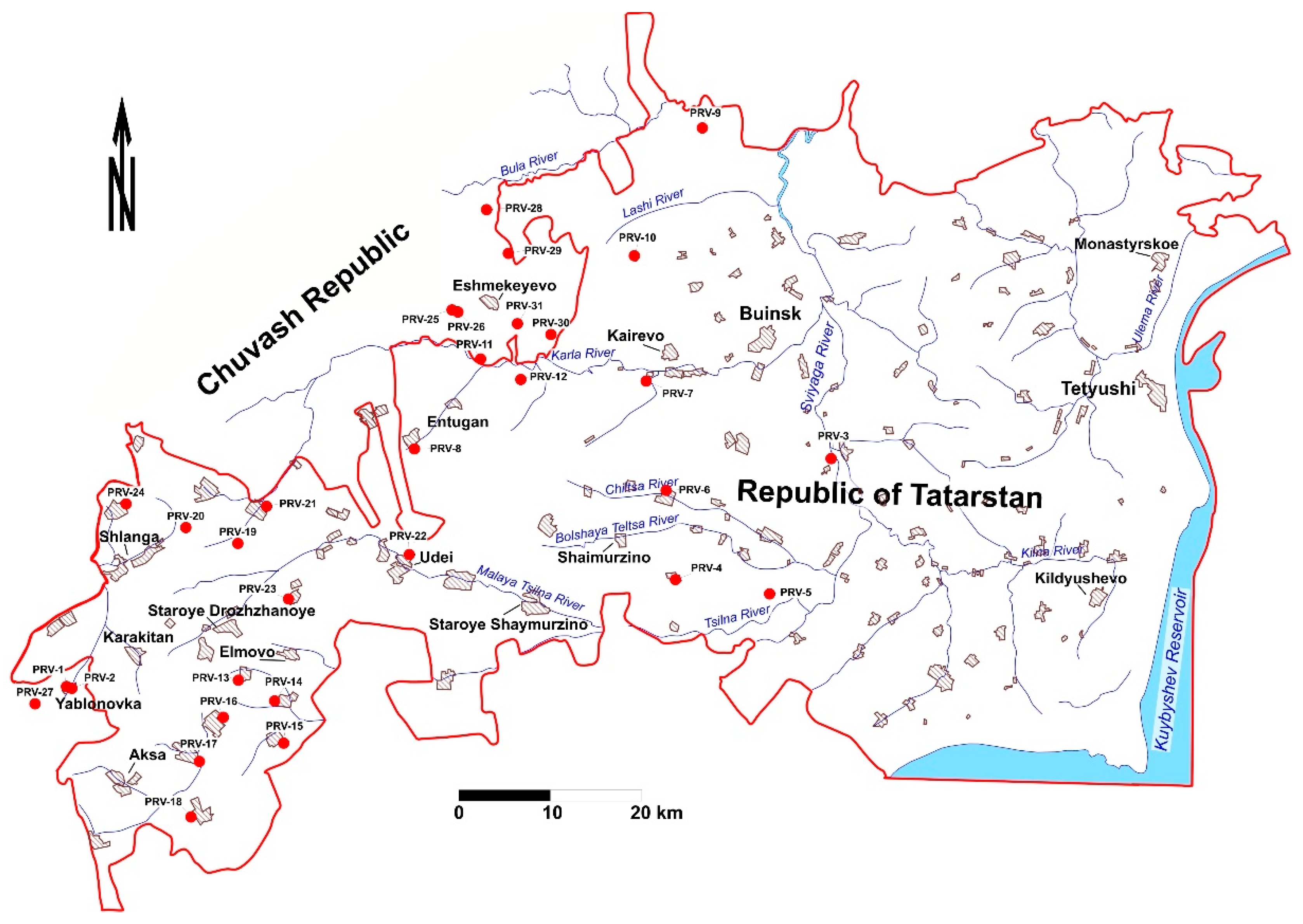
In 2020 during August 15–28 on the study area 33 groundwater samples were taken from the Quaternary, Cretaceous, Jurassic and Permian aquifers at depths down to 400 m (
Figure 3 and
Table A1). Water samples were mainly taken from boreholes operated by submersible electric pumps, and in some cases from wells and springs.
Unstable parameters—pH, Eh (redox potential), electrical conductivity (mineralization), and temperature—were determined in the field immediately after sampling. The measurement of pH and Eh was carried out using a portable combined device, Hanna Instruments HI-9126 (Hanna Instruments, Woonsocket, USA), and the electrical conductivity and water temperature—using a conductometer, VZOR Mark-603/1 (LLC “VZOR”, Moscow, Russia).
Water samples to determine the trace metals were taken in 50 mL plastic bottles, filtered through a membrane filter with a pore size of 0.45 μm, and acidified by high purity grade HNO
3 to pH < 2. Disposable gloves and syringes were used for each sample. The content of trace elements was measured by the atomic absorption method using a Shimadzu AA-7000 spectrometer. In 1999–2007, the chemical composition of the groundwater (major components, as a rule, and microelements in small part of samples) was studied by standard chemical techniques in 839 samples [
56].
Water samples for the stable isotopes (δ2H and δ18O) were taken in plastic bottles with a volume of 10 mL without conservation. Determination of δ2H and δ18O was carried out using a Picarro L-2120i infrared ring-down spectrometer (Picarro Inc., Santa Clara, CA, USA) in the Research park of Saint-Petersburg State University. The results were expressed in δ-notation relative to the Vienna Standard Mean Ocean Water (V-SMOW-2). The precision of the method is ±0.1‰ for δ18O and ±1.0‰ for δ2H. Standards USGS-45 and USGS-46 were used for calibration.
Preconcentration of uranium was preconcentrated from 25 L water samples under field conditions using BAU-A (charcoal) sorbent. The yield of uranium was controlled by the activity of synthetic 232U isotope as tracer, which was added to the samples during collection. Radiochemical preparation included the desorption of uranium from sorbent, purification from co-precipitated radioactive elements by the extraction method using tributyl phosphate, and electrolytic deposition of uranium on polished stainless-steel discs. The measurements were performed by semiconductor alpha spectrometers Progress and Multirad-AS (from Doza, Russia) with an error of 3–7%. The quality of the measurements was checked by analyzing an OSK U7 equilibrium uranium reference sample (VIMS Institute, Moscow, Russia).
4. Results and Discussion
Generally, in the study area the vertical chemical zonation of the groundwater is as follows [
56].
At depths from 0 to 100 m, mainly fresh water is contained (salinity in gram per liter and contents of chemical components in % mg-eq./L):
| S = 0.4–1.0 | HCO3(70–96) NO3(1–18) Cl(1–6) SO4(1–6) | pH = 7.5–7.8. |
| Ca(22–69) Mg(7–49) Na(2–37) |
In the river valleys, where discharge of the brackish deep-water occurred, the sulfate-sodium type of groundwater is formed:
| S = 0.9–1.8 | SO4(36–63) HCO3(27–52) Cl(2–17) | pH = 7.3–8.1. |
| Na(14–86) Mg(9–27) Ca(7–17) |
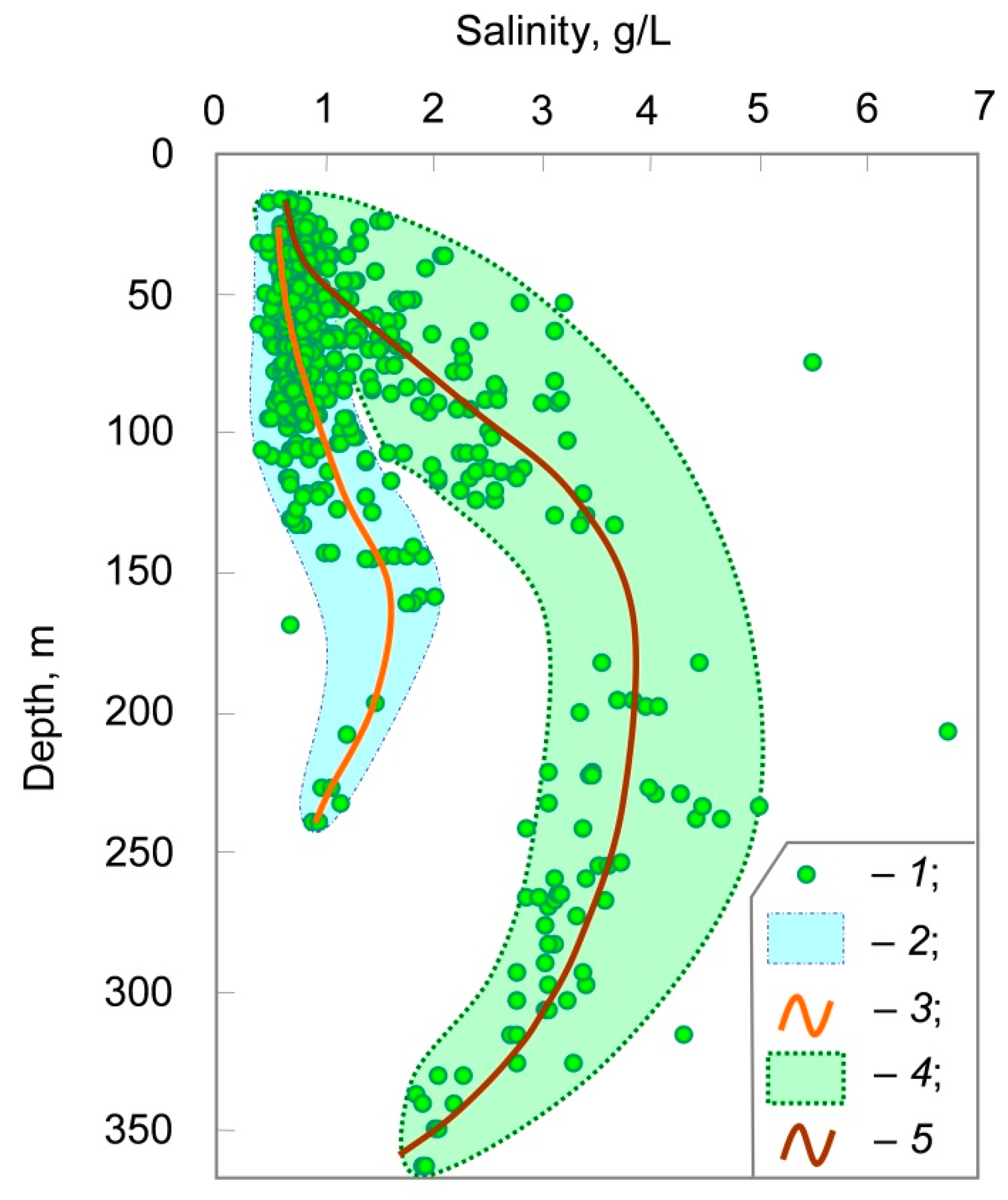
At depths of 70–250 m, mineralization increases (up to a maximum 6.9 g/L) and the chemical composition of the groundwater changes:
| S = 2.0–6.9 | SO4(46–85) Cl(7–51) HCO3(8–39) | pH = 7.1–7.8. |
| Na(37–80) Ca(11–35) Mg(9–28) |
The initial chemical composition of groundwater in this zone was formed, most likely, under the gypsum dissolution, and later calcium was partially exchanged with sodium from sediments.
At depths of 250–400 m, there is a noticeable decrease of salinity and the next change in the chemical composition of groundwater:
| S = 1.8–4 | Cl(34–71) SO4(18–32) HCO3(2–7) | pH = 7.5–8.5. |
| Ca(45–74) Mg(6–21) Na(12–34) |
Thus, a specific feature of this region is vertical chemical inversion (
Figure 4), which is mainly caused by variations in the SO
42−, Ca
2+ and Na
+ content.
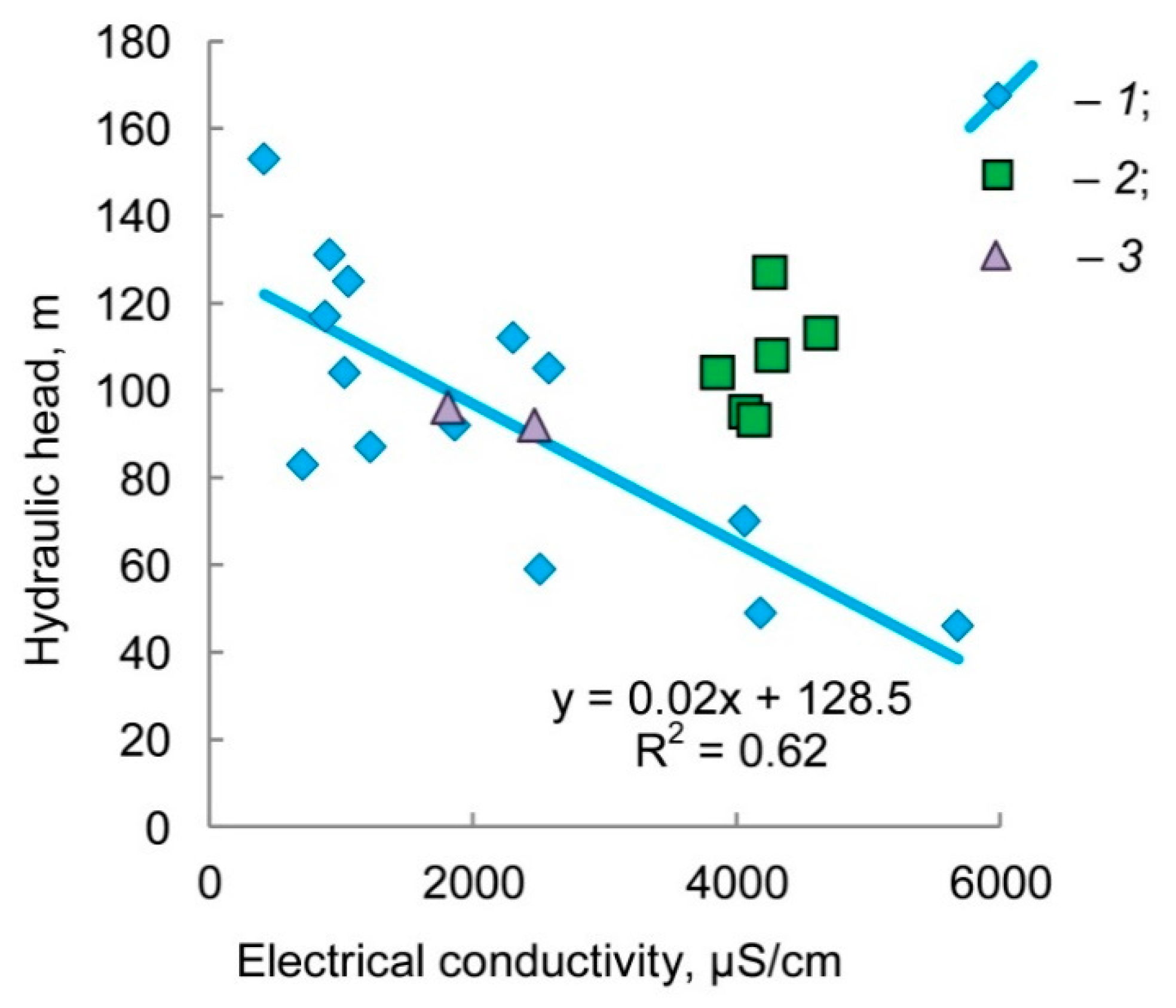
River valleys are the most probable areas for the upward discharge of brackish deep-water. Such anomalies are simultaneously observed in the groundwater salinity, the hydraulic head, and the uranium isotopic composition (
Figure 5 and
Figure 6). Hereinafter, the term “anomalies of the uranium isotopic composition” will mean the ratio
234U/
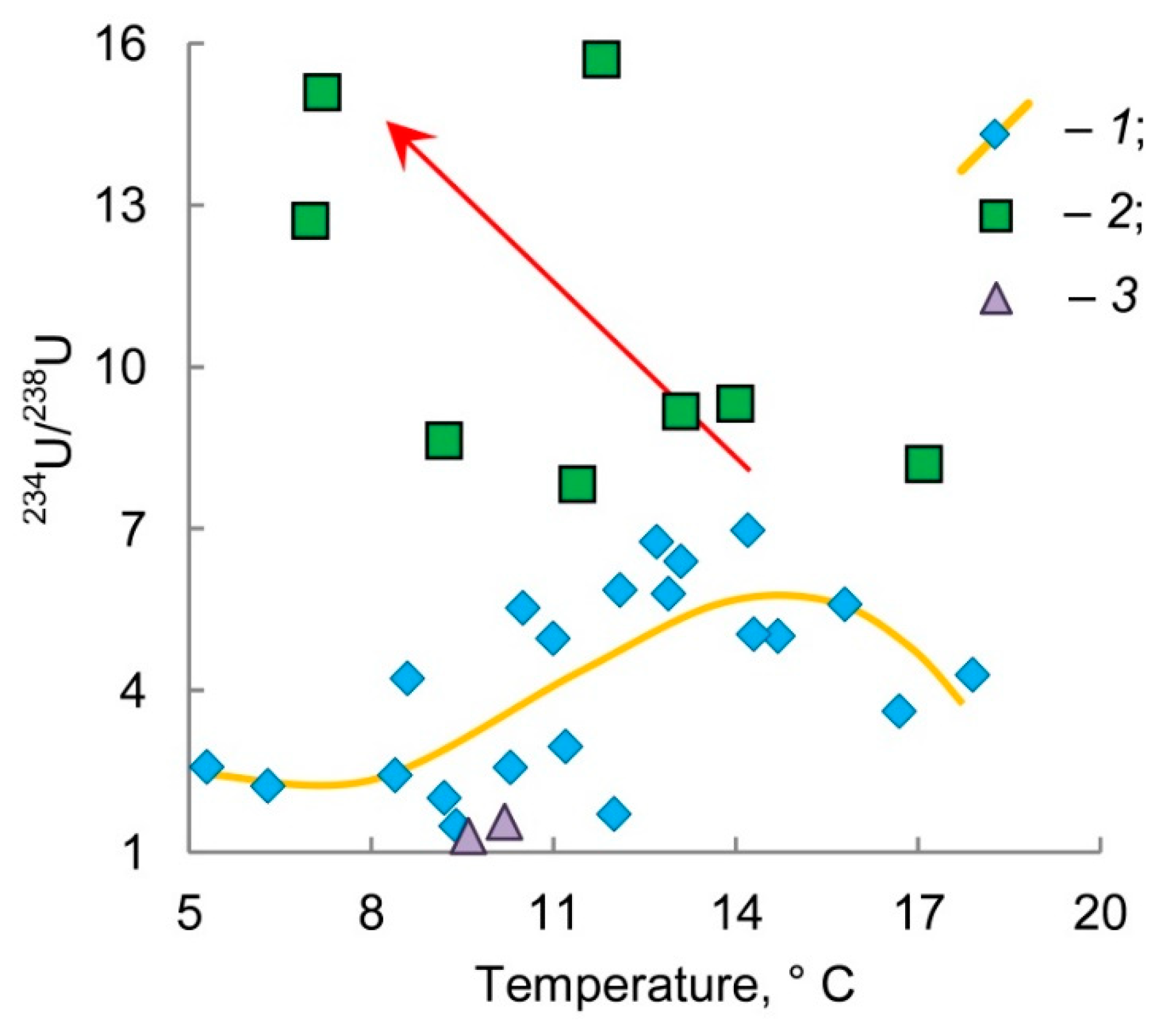
238U > 7.8, i.e., the top quantile of the total samples. Watersheds with low mineralization of groundwater and a regular hydraulic head are areas of modern recharge. In the areas with anomalies of the isotopic composition of uranium, the groundwater also has relatively low temperatures (
Figure 7).
Anomalies in the
234U/
238U ratios were found in groundwater with different salinity, S = 0.4–2.4 g/L, which is a result of mixing when the brackish deep-water moves upward to the modern surface due to excess of the hydraulic head (
Figure 6). The mixing of groundwater significantly complicates the interpretation of the chemical and
234U/
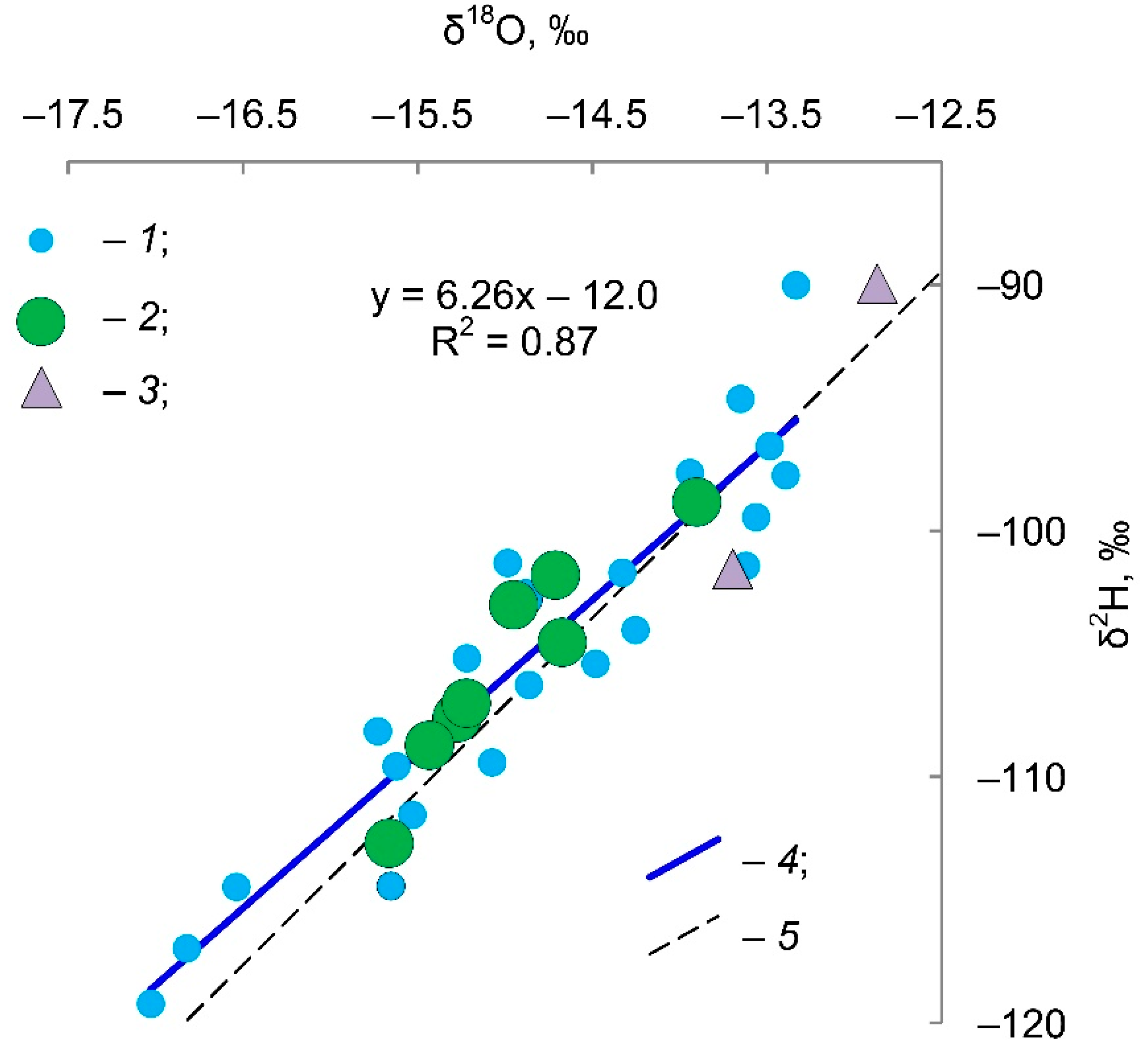
238U data. Therefore, the stable isotope composition of the groundwater (δ
18O and δ
2H) was determined (
Figure 8).
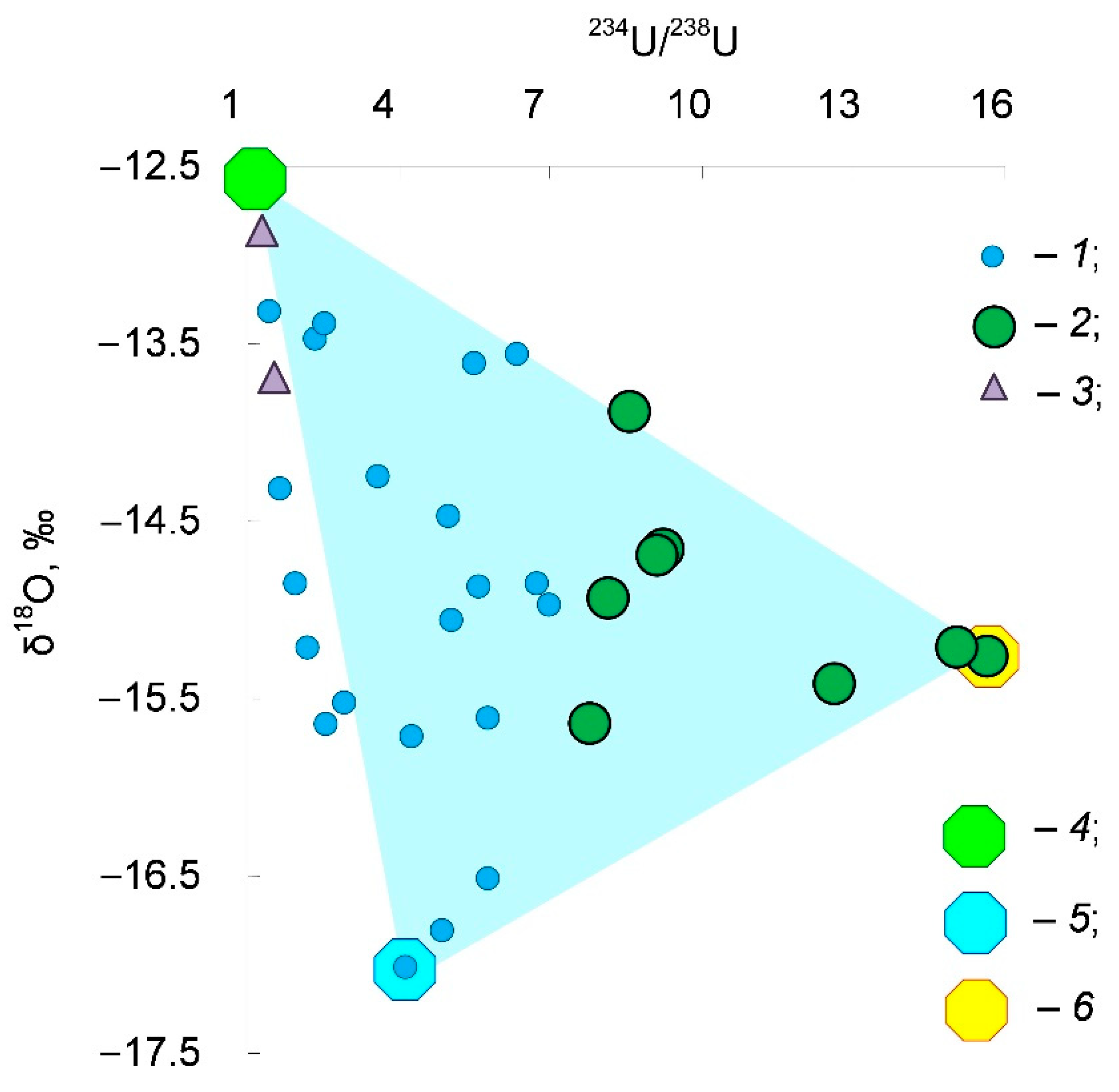
Comparison of the
234U/
238U ratios and the stable isotope compositions of groundwater in the Pre-Volga region shows the three-component mixture of the groundwater (
Figure 9).
Modern and/or young (Holocene age) recharge water with salinity S < 0.5 g/L. It has the least depletion in the isotopic composition of hydrogen and oxygen δ18O → −12.9 ‰ and δ2H → −90 ‰, which is close to the modern precipitation of the region, and practically the equilibrium isotope composition of uranium 234U/238U → 1.
Water of the late and/or postglacial genesis. It has a slight increase in salinity S ≈ 0.5–1.5 g/L, the isotopically lightest composition δ18O → −17.0 ‰ and δ2H → −119 ‰ (maybe water of a proglacial lake?), and a small excess of uranium-234 234U/238U ≈ 4.
The glacial meltwater formed due to the permafrost thawing. It is the brackish water S → 3 g/L (for these 33 samples under consideration). This water has the intermediate composition of the stable isotopes δ18O ≈ −15.0 ‰ and δ2H ≈ −110 ‰ (ice in permafrost, most likely, formed from mixture water of the Valdai cryochron and the previous interstadial), and maximum disequilibrium in uranium 234U/238U → 15.7.
Theoretically, as a result of the cryogenic metamorphization during permafrost formation, the glacial meltwater should have:
reduced mineralization, as salts must be lost in the freezing process;
an isotope composition of hydrogen and oxygen with less depletion than the recharge water (points must have a shift to the right from the meteoric line on the δ2H vs. δ18O diagram).
The salinity of the glacial meltwater in the Pre-Volga region varies within a wide range S = 0.4–2.4 g/L. This could result from the presence of evaporites in the water-bearing sediments and the increased solubility of the iron and manganese sulfates (melanterite and jarosite) at near-zero temperature. During the Valdai cryochron, the temperature of the geological section transited through zero many times, which led to the predominance of sulfates in the anionic composition.
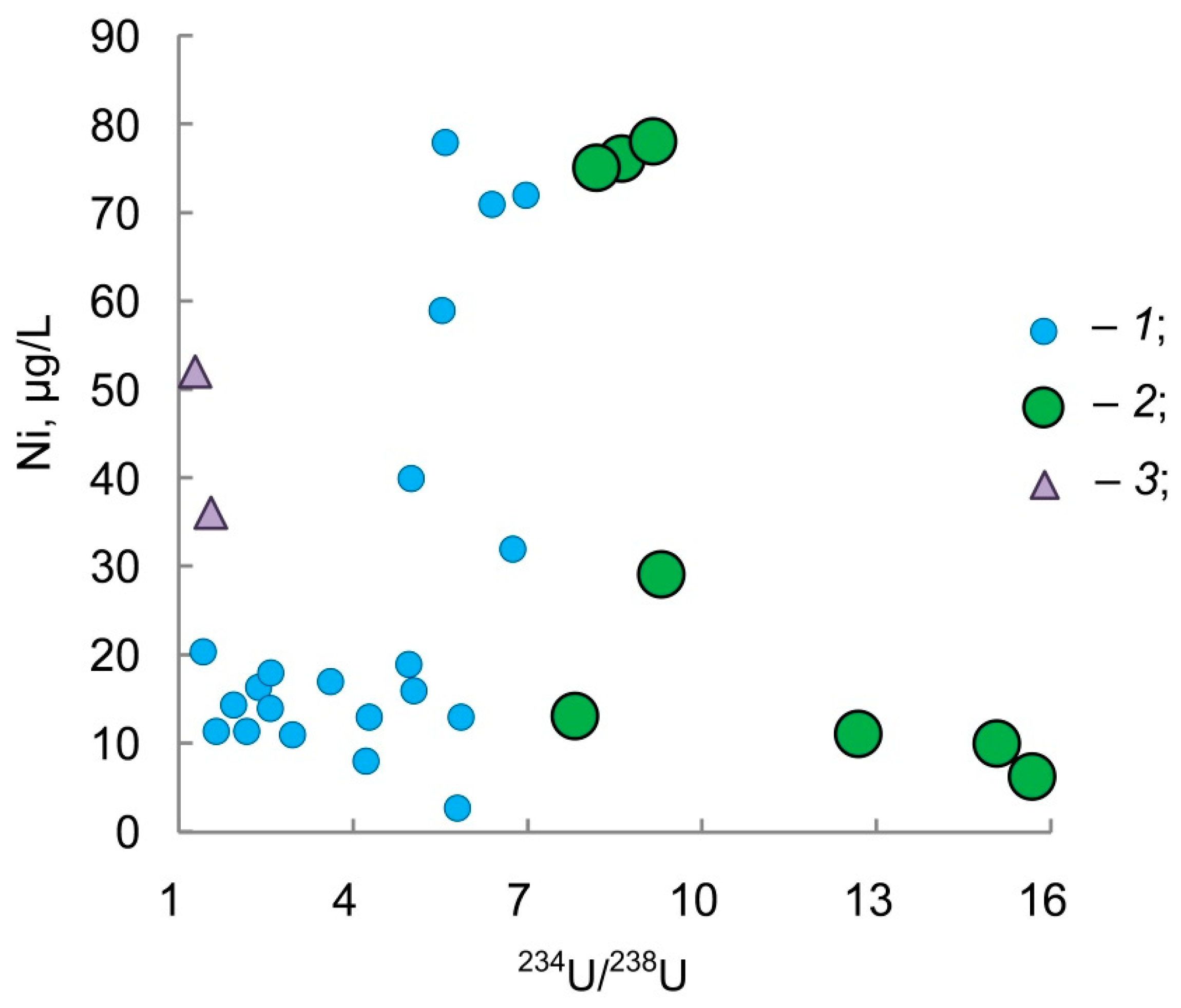
An explanation should be given about two data points designated in all the above diagrams by term “outliers”. It can clearly be seen from stable isotopes and from the
234U/
238U ratio (
Figure 8) that it is modern groundwater. The chemical composition of groundwater at these two points does not fit the general picture (see excess of Ni on
Figure 10) due to the local geochemical specialization of water-bearing rocks.
5. Conclusions
The proxy markers of the existence of permafrost were found in the isotope and chemical compositions of groundwater for the Pre-Volga region. Joint analysis of the groundwater chemistry, the isotopic composition of uranium (234U/238U by activity), and the stable isotopes (contents of deuterium and oxygen-18) made it possible to define the contribution of the mixing of three end-members:
Modern and/or young recharge water of the infiltration origin has the lowest salinity S < 500 mg/L, the heaviest stable isotope composition δ18O → −12.9 ‰ and δ2H → −90 ‰ close to modern precipitation, and practically equilibrium uranium 234U/238U → 1;
Late and/or postglacial water, which has a slight increase in mineralization S ≈ 0.5–1.5 g/L, the lightest isotopic composition δ18O → −17.0 ‰ and δ2H → −119 ‰, and a small excess of uranium-234 234U/238U ≈ 4;
Glacial meltwater (groundwater formed from thawing permafrost) has increased salinity S → 3 g/L, an intermediate composition of the stable isotopes δ18O ≈ −15.0 ‰ and δ2H ≈ −110 ‰, and maximum excess of uranium-234 234U/238U → 15.7.
None of the end-members were found in a pure form, except the modern infiltration water, which is due to the impossibility of carrying out special drilling operations to test the geological section within this study. However, this typing of groundwater is in accordance with a general trend of the climate evolution on the studied area in the Late Pleistocene and Holocene. Using isotope tracers makes it possible to eliminate the difficulties caused by the variety of conditions of chemical interaction in the water‒rock system in identifying glacial meltwater.
Analysis of the chemical data indicates the existence of geochemical specialization in certain locations of the studied area, possibly associated with explosive tectonics.
In the next stage, a detailed sampling at the sites of the clearest manifestation of the glacial meltwater and carrying out monitoring observations are planned.


