Soil Moisture Estimation Using Citizen Observatory Data, Microwave Satellite Imagery, and Environmental Covariates


Abstract
1. Introduction
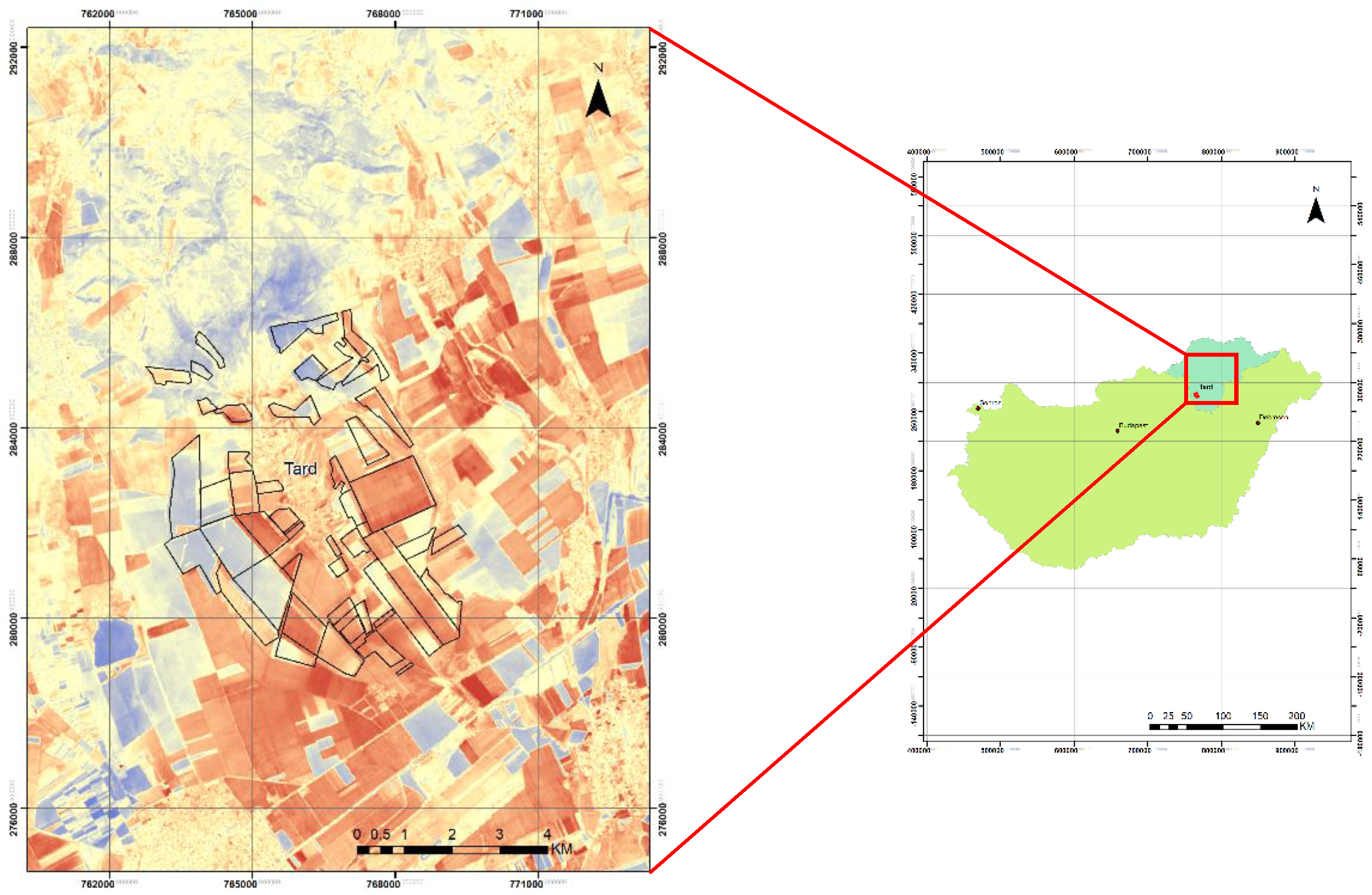
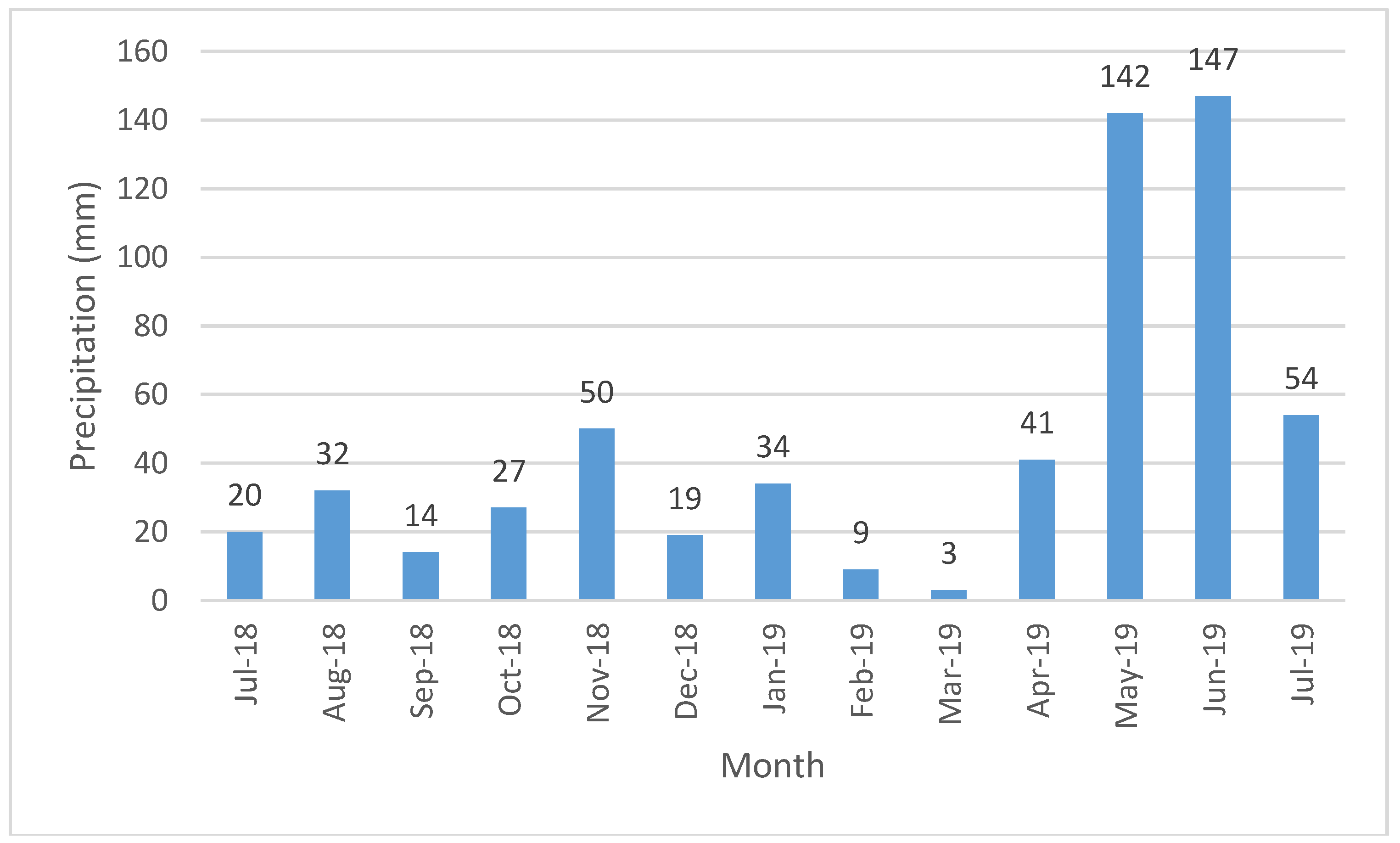
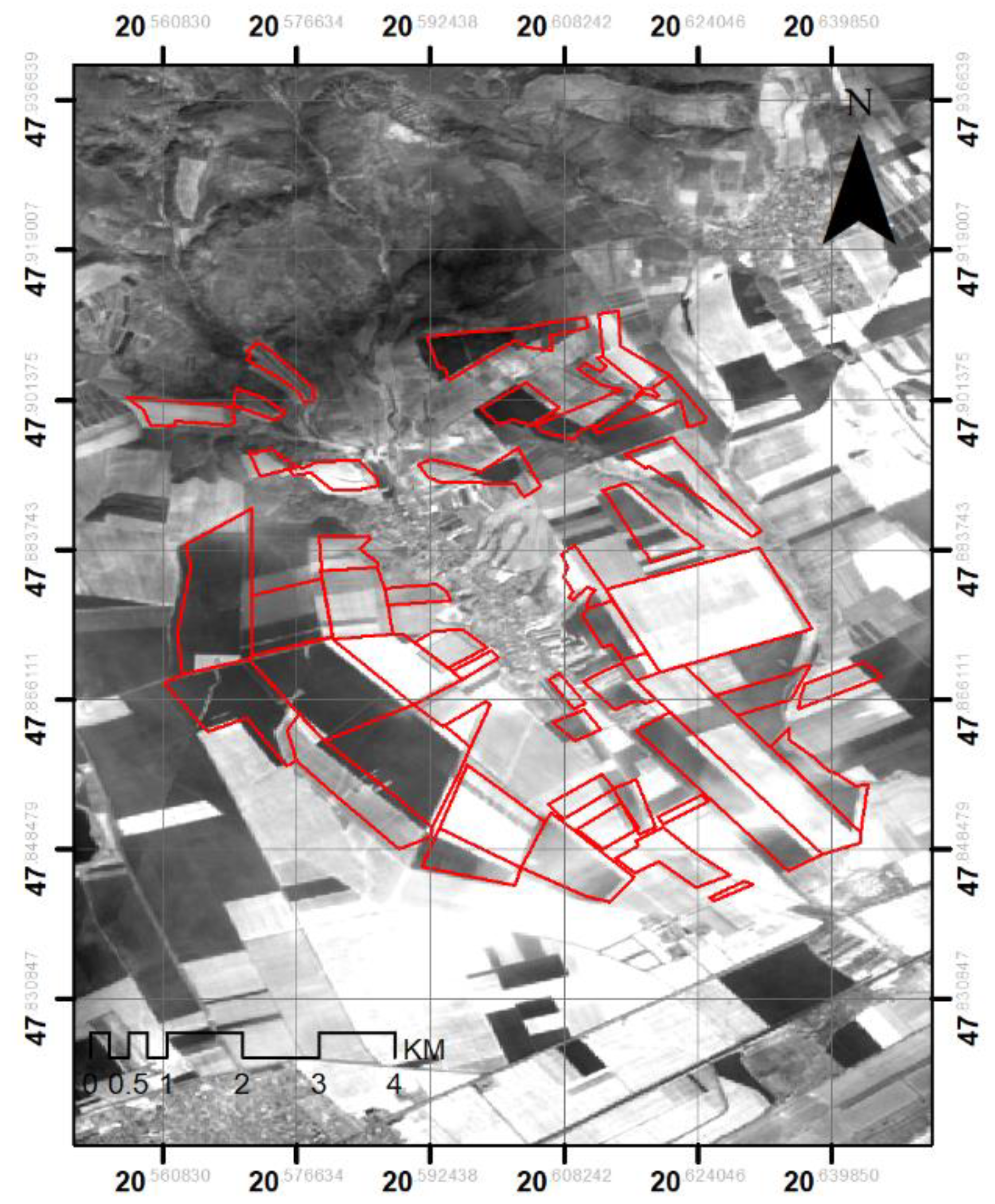
2. Study Area
3. Materials and Methods
3.1. Materials
3.1.1. Field Data
3.1.2. Sentinel 1 Imagery
3.1.3. Landsat 8 Imagery
3.2. Methods
3.2.1. Data Collection and Retrieval of Measured Soil Moisture
3.2.2. Extraction of Covariates
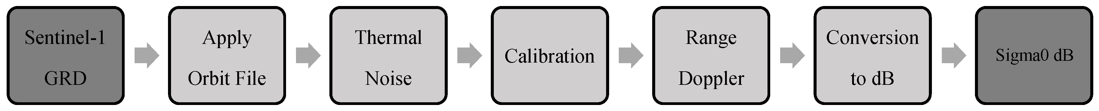
3.2.3. Pre-Processing and Selection of Sentinel 1 Imagery
Apply Orbit
Thermal Noise Removal
Calibration
Range Doppler Terrain Correction
Conversion of the Image to dB
3.2.4. Spatial Interpolation Methods
Multiple Linear Regression (MLR)
Regression Kriging (RK)
Cokriging (CK)
3.2.5. Estimation of Soil Moisture
3.2.6. Validation of Soil Moisture
4. Results and Discussion
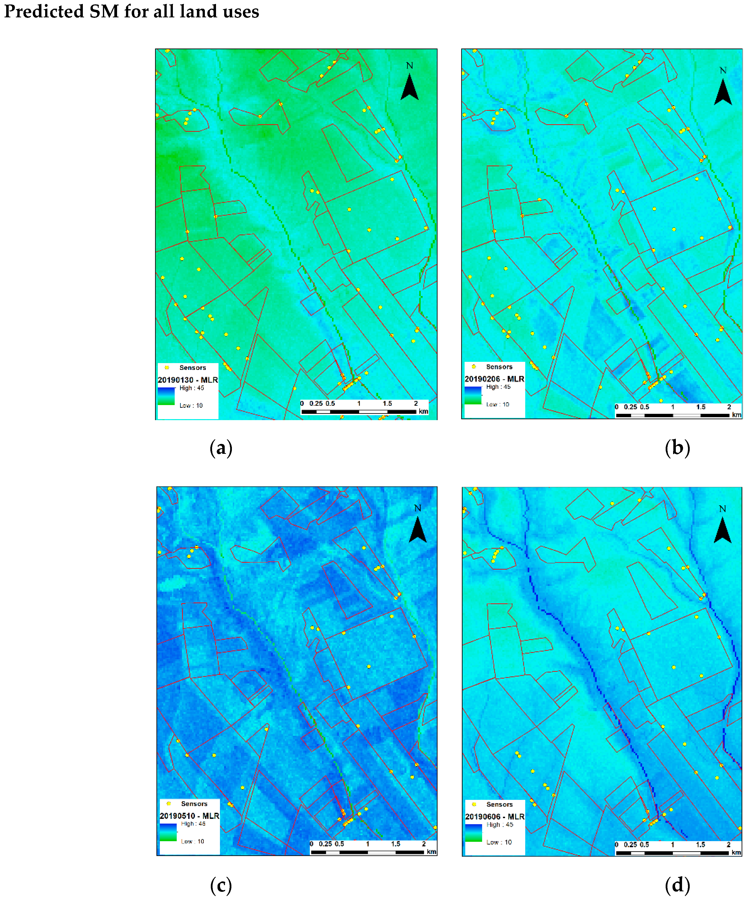
4.1. Multiple Linear Regression (MLR)
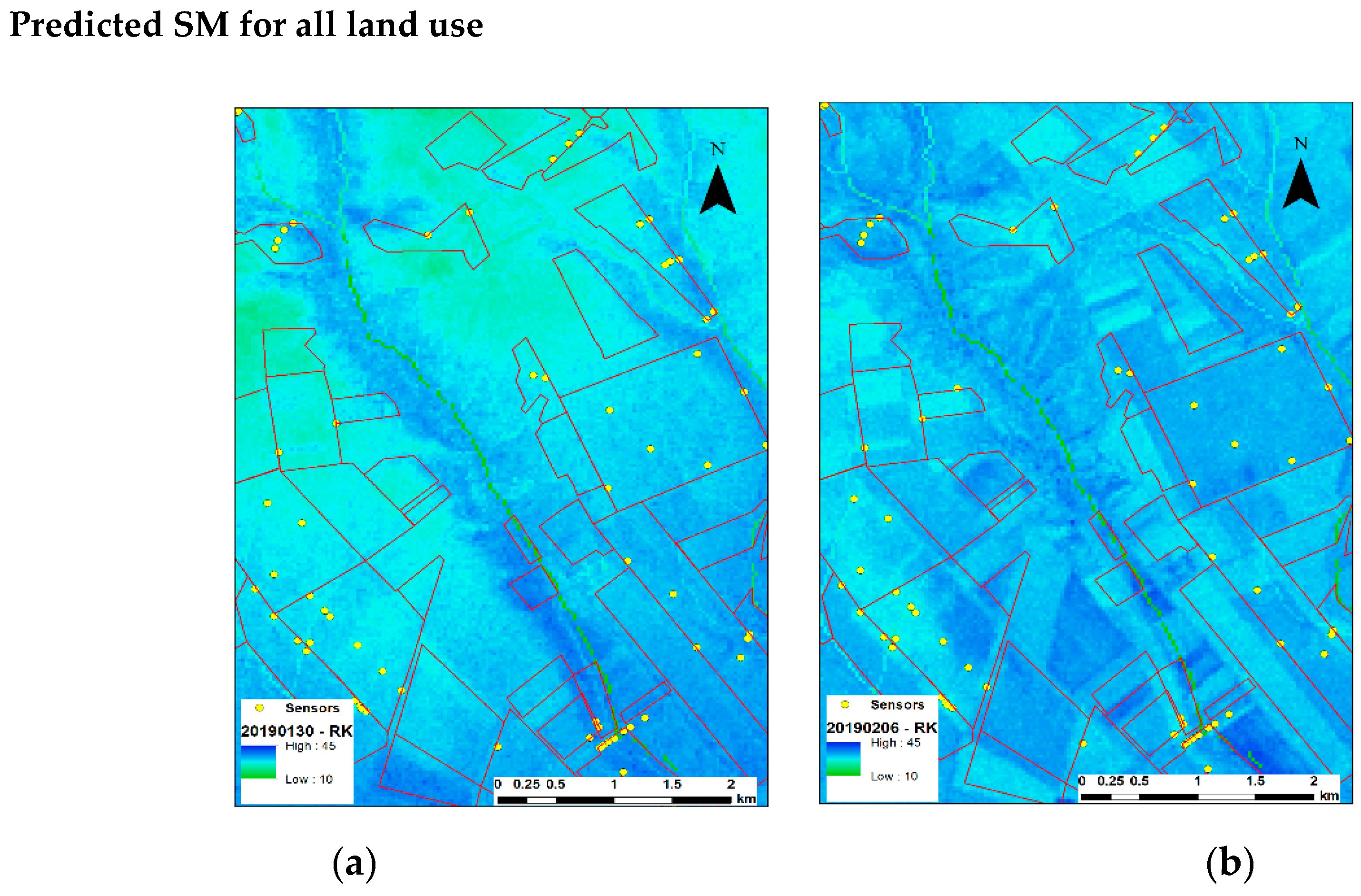
4.2. Regression Kriging
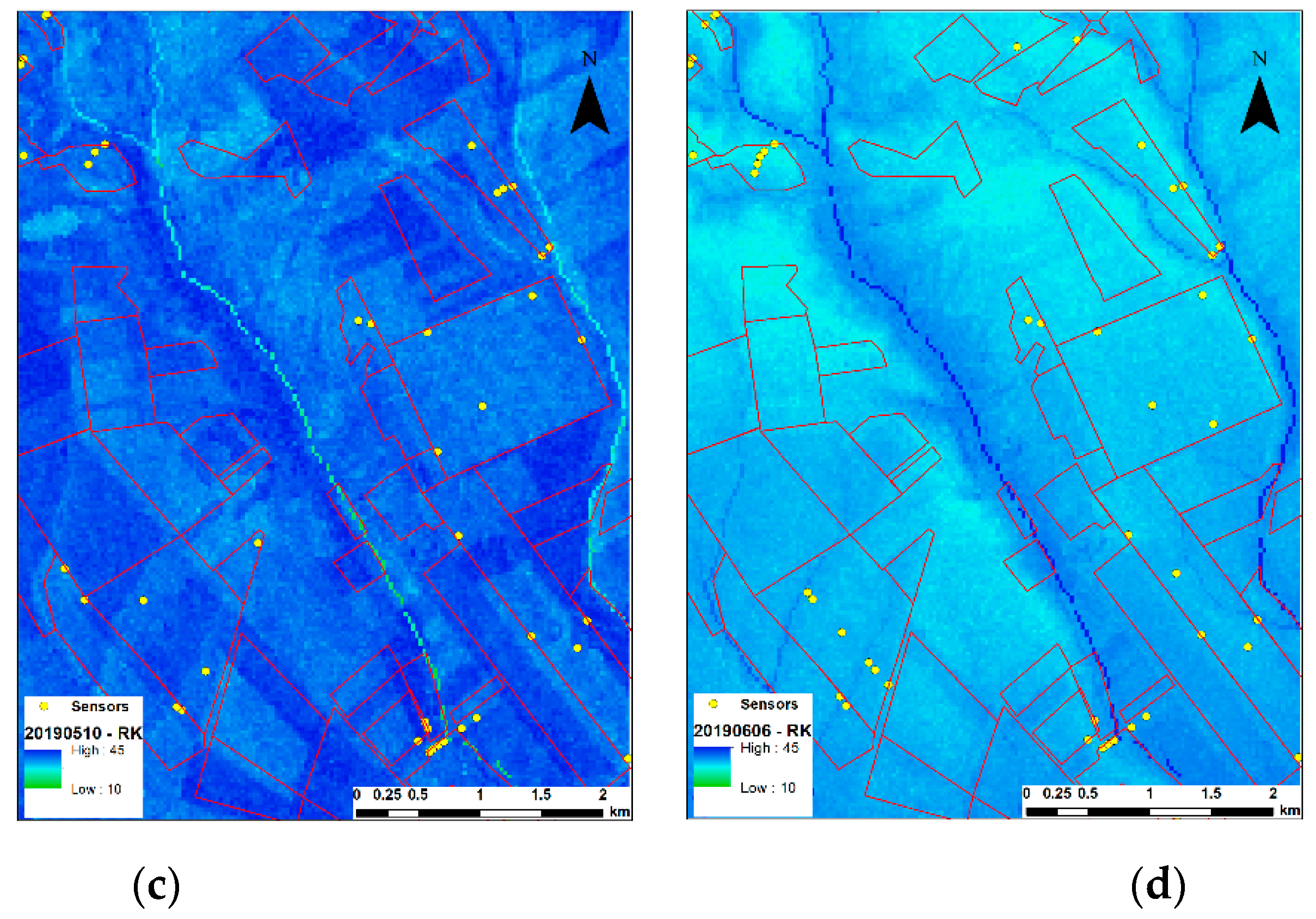
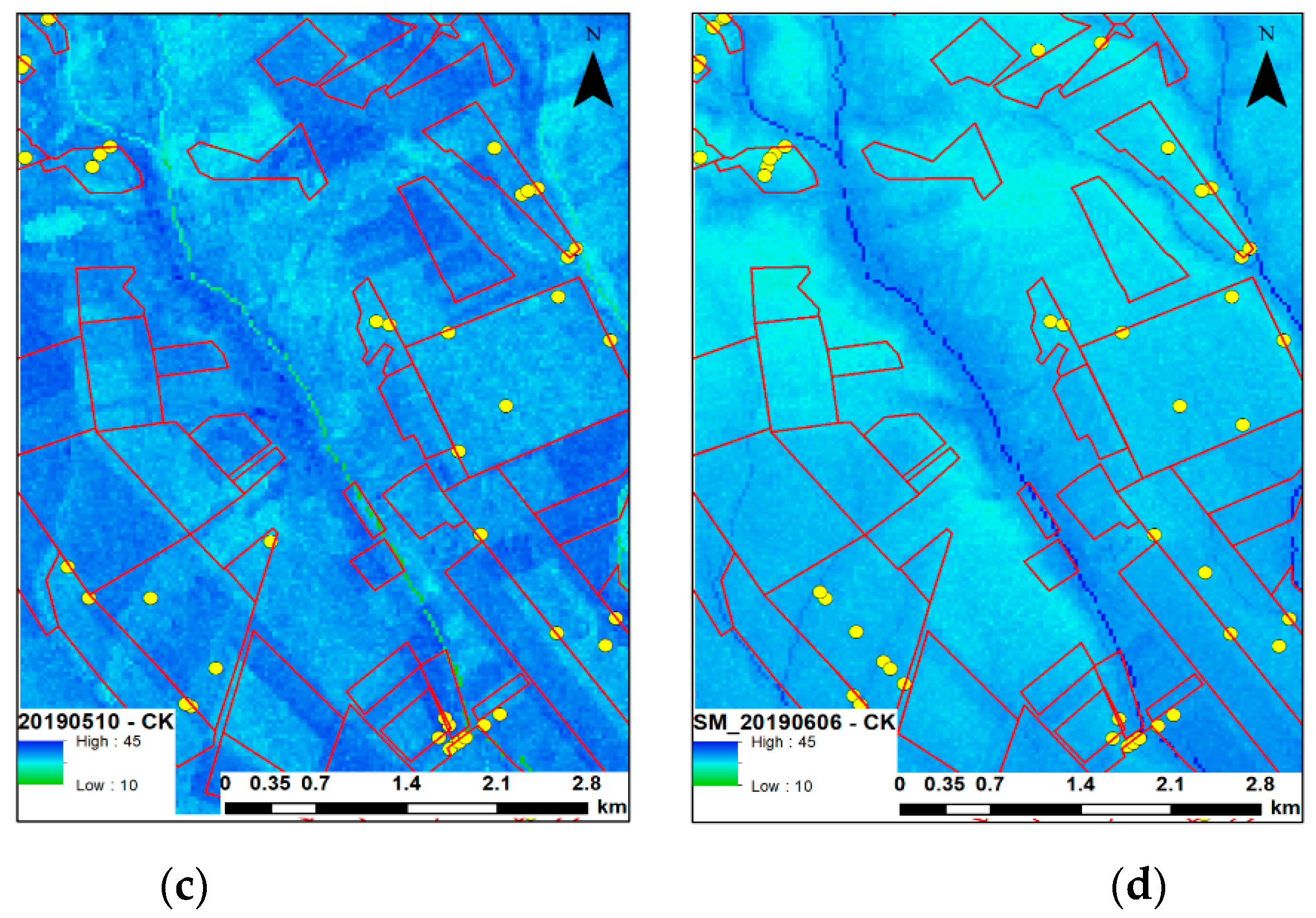
4.3. Ordinary Cokriging
4.4. Comparison of the Results
5. Conclusions
Author Contributions
Funding
Acknowledgments
Conflicts of Interest
References
- Bablet, A.; Viallefont, F.; Fabre, S.; Briottet, X.; Jacquemoud, S. Assessment of Soil Moisture Content Using a Multilayer Radiative Transfer Model of Soil Reflectance (MARMIT) in the Solar Domain. Geophys. Res. Abstr. 2018, 20, 17709. [Google Scholar]
- Entekhabi, D.; Njoku, E.G.; O’Neill, P.E.; Kellogg, K.H.; Crow, W.T.; Edelstein, W.N.; Van Zyl, J. The Soil Moisture Active Passive (SMAP) Mission. Proc. IEEE 2010, 98, 704–716. [Google Scholar] [CrossRef]
- Kovács, K.Z.; Hemment, D.; Woods, M.; Van Der Velden, N.K.; Xaver, A.; Giesen, R.H.; Burton, V.J.; Garrett, N.; Zappa, L.; Long, D.; et al. Citizen Observatory Based Soil Moisture Monitoring—The Grow Example. Hung. Geogr. Bull. 2019, 68, 119–139. [Google Scholar] [CrossRef]
- Dorigo, W.A.; Oevelen, P.; Wagner, W.; Drusch, M.; Mecklenburg, S.; Robock, A.; Jackson, T. A New International Network for in Situ Soil Moisture Data. Eos Trans. Am. Geophys. Union 2011, 92, 141–142. [Google Scholar] [CrossRef]
- Dorigo, W.A.; Wagner, W.; Hohensinn, R.; Hahn, S.; Paulik, C.; Xaver, A.; Robock, A. The International Soil Moisture Network: A Data Hosting Facility for Global in Situ Soil Moisture Measurements. Hydrol. Earth Syst. Sci. 2011, 15, 1675–1698. [Google Scholar] [CrossRef]
- Indian People Organizing for Change. Climate Change 2007: The Physical Science Basis. Agenda 2007, 6, 333. [Google Scholar]
- Xaver, A.; Zappa, L.; Rab, G.; Pfeil, I.; Vreugdenhil, M.; Hemment, D.; Dorigo, W.A. Evaluating the Suitability of the Consumer Low-Cost Parrot Flower Power Soil Moisture Sensor for Scientific Environmental Applications. Geosci. Instrum. Methods Data Syst. 2020, 9, 117–139. [Google Scholar] [CrossRef]
- Freitag, A.; Meyer, R.; Whiteman, L. Strategies Employed by Citizen Science Programs to Increase the Credibility of Their Data. Citiz. Sci. Theory Pract. 2016, 1. [Google Scholar] [CrossRef]
- Pocock, M.J.O.; Tweddle, J.C.; Savage, J.; Robinson, L.D.; Roy, H.E. The Diversity and Evolution of Ecological and Environmental Citizen Science. PLoS ONE 2017, 12, e0172579. [Google Scholar] [CrossRef]
- Gharesifard, M.; Wehn, U.; Van Der Zaag, P. Towards Benchmarking Citizen Observatories: Features and Functioning of Online Amateur Weather Networks. J. Environ. Manag. 2017, 193, 381–393. [Google Scholar] [CrossRef]
- Woods, M.; Hemment, D.; Ajates, R.; Cobley, A.; Xaver, A.; Konstantakopoulos, G. GROW Citizens’ Observatory: Leveraging the power of citizens, open data and technology to generate engagement, and action on soil policy and soil moisture monitoring. In IOP Conference Series: Earth and Environmental Science; IOP Publishing: Bristol, UK, 2020; Volume 509, p. 012060. [Google Scholar]
- Al-Yaari, A.; Wigneron, J.-P.; Kerr, Y.; Rodríguez-Fernández, N.J.; O’Neill, P.E.; Jackson, T.J.; Yueh, S. Evaluating Soil Moisture Retrievals from Esa’s Smos and Nasa’s Smap Brightness Temperature Datasets. Remote. Sens. Environ. 2017, 193, 257–273. [Google Scholar] [CrossRef]
- Zhang, G.-L.; Liu, F.; Song, X.-D. Recent Progress and Future Prospect of Digital Soil Mapping: A Review. J. Integr. Agric. 2017, 16, 2871–2885. [Google Scholar] [CrossRef]
- McBratney, A.B.; Santos, M.M.; Minasny, B. On Digital Soil Mapping. Geoderma 2003, 117, 3–52. [Google Scholar] [CrossRef]
- Boettinger, J.; Howell, D.; Moore, A.; Hartelink, A.; Kienast-brown, S. Digital Soil Mapping; Springer Netherlands: Dordrecht, The Netherlands, 2010. [Google Scholar] [CrossRef]
- Bakker, A. Soil Texture Mapping on a Regional Scale with Remote Sensing Data. 2012. Available online: https://edepot.wur.nl/246954 (accessed on 24 July 2020).
- Jenny, H. Factors of Soil Formation. In A System of Quantitative Pedology, Soil Science; Dover Publications: Mineola, NY, USA, 1941. [Google Scholar]
- Rossiter, D.G. Digital Soil Resource Inventories: Status and Prospects. Soil Use Manag. 2006, 20, 296–301. [Google Scholar] [CrossRef]
- Malone, B.P.; Minasny, B.; McBratney, A.B. Digital Soil Mapping; Springer: Cham, Switzerland, 2017; pp. 1–5. [Google Scholar] [CrossRef]
- Zribi, M.; Albergel, C.; Baghdadi, N. Editorial for the Special Issue “Soil Moisture Retrieval using Radar Remote Sensing Sensors”. Remote Sens. 2020, 12, 1100. [Google Scholar] [CrossRef]
- Montanarella, L.; Pennock, D.J.; McKenzie, N.; Badraoui, M.; Chude, V.; Baptista., I. World’s Soils Are under Threat. Alice 2016, 2, 79–82. [Google Scholar] [CrossRef]
- Colliander, A.; Cosh, M.H.; Misra, S.; Jackson, T.J.; Crow, W.T.; Chan, S.; Bindlish, R.; Chae, C.; Collins, C.H.; Yueh, S.H. Validation and Scaling of Soil Moisture in a Semi-Arid Environment: Smap Validation Experiment 2015 (SMAPVEX15). Remote Sens. Environ. 2017, 196, 101–112. [Google Scholar] [CrossRef]
- Bousbih, S.; Zribi, M.; El Hajj, M.; Baghdadi, N.; Chabaane, Z.L.; Gao, Q.; Fanise, P. Soil Moisture and Irrigation Mapping in A Semi-Arid Region, Based on the Synergetic Use of Sentinel-1 and Sentinel-2 Data. Remote. Sens. 2018, 10, 1953. [Google Scholar] [CrossRef]
- Xing, M.; He, B.; Ni, X.; Wang, J.; An, G.; Shang, J.; Huang, X. Retrieving Surface Soil Moisture over Wheat and Soybean Fields during Growing Season Using Modified Water Cloud Model from Radarsat-2 SAR Data. Remote Sens. 2019, 11, 1956. [Google Scholar] [CrossRef]
- Gharechelou, S.; Tateishi, R.; Sharma, R.C.; Johnson, B.A. Soil Moisture Mapping in an Arid Area Using a Land Unit Area (LUA) Sampling Approach and Geostatistical Interpolation Techniques. ISPRS Int. J. Geo-Inf. 2016, 5, 35. [Google Scholar] [CrossRef]
- Keskin, H.; Grunwald, S. Regression Kriging as a Workhorse in the Digital Soil Mapper's Toolbox. Geoderma 2018, 326, 22–41. [Google Scholar] [CrossRef]
- Han, Y.; Bai, X.; Shao, W.; Wang, J. Retrieval of Soil Moisture by Integrating Sentinel-1A and MODIS Data over Agricultural Fields. Water 2020, 12, 1726. [Google Scholar] [CrossRef]
- Zeng, L.; Shi, Q.; Guo, K.; Xie, S.; Herrin, J.S. A Three-Variables Cokriging Method to Estimate Bare-Surface Soil Moisture Using Multi-Temporal, Vv-Polarization Synthetic-Aperture Radar Data. Hydrogeol. J. 2020, 1–11. [Google Scholar] [CrossRef]
- Chatterjee, S.; Huang, J.; Hartemink, A.E. Establishing an Empirical Model for Surface Soil Moisture Retrieval at the U.S. Climate Reference Network Using Sentinel-1 Backscatter and Ancillary Data. Remote Sens. 2020, 12, 1242. [Google Scholar] [CrossRef]
- Zhang, J.; Li, X.; Yang, R.; Liu, Q.; Zhao, L.; Dou, B. An Extended Kriging Method to Interpolate Near-Surface Soil Moisture Data Measured by Wireless Sensor Networks. Sensors 2017, 17, 1390. [Google Scholar] [CrossRef]
- Hengl, T.; Heuvelink, G.B.M.; Stein, A. A Generic Framework for Spatial Prediction of Soil Variables Based On Regression-Kriging. Geoderma 2004, 120, 75–93. [Google Scholar] [CrossRef]
- IUSS Working Group WRB (Ed.) World Reference Base for Soil Resources 2006. In World Soil Resources Reports; Food and Agriculture Organization of the United Nations: Rome, Italy, 2006. [Google Scholar]
- USDA-NRCS. Keys to Soil Taxonomy, 12th ed.; USDA-NRCS: Washington, DC, USA, 1998.
- Dobos, E.; Daroussin, J.; Montanarella, L. A Quantitative Procedure for Building Physiographic Units Supporting a Global Soter Database. Hungarian Geogr. Bull. 2010, 59, 181–205. [Google Scholar]
- Hosseini, R.; Newlands, N.K.; Dean, C.B.; Takemura, A. Statistical Modeling of Soil Moisture, Integrating Satellite Remote-Sensing (SAR) and Ground-Based Data. Remote Sens. 2015, 7, 2752–2780. [Google Scholar] [CrossRef]
- Dobos, E.; Michéli, E.; Baumgardner, M.F.; Biehl, L.; Helt, T. Use of Combined Digital Elevation Model and Satellite Radiometric Data for Regional Soil Mapping. Geoderma 2000, 97, 367–391. [Google Scholar] [CrossRef]
- EEA. Digital Elevation Model over Europe (EU-DEM). 2013. Available online: https://www.eea.europa.eu/data-and-maps/data/eu-dem (accessed on 1 April 2020).
- Dobos, E.; Daroussin, J. Calculation of Potential Drainage Density Index (PDD) Potential Drainage Density Index (PDD). In Digital Terrain Modelling; Springer: Berlin, German, 2007; pp. 283–295. [Google Scholar] [CrossRef]
- Filipponi, F. Sentinel-1 GRD Pre-processing Workflow . Proceedings 2019, 18, 11. [Google Scholar] [CrossRef]
- SNAP Software. SAR Basics Tutorial. 2019. Available online: http://step.esa.int/docs/tutorials/S1TBX%20SAR%20Basics%20Tutorial.pdf (accessed on 24 July 2020).
- Park, J.; Korosov, A.A.; Babiker, M.; Sandven, S. Efficient Thermal Noise Removal for Sentinel-1. IEEE Trans. Geosci. Remote Sens. 2017, 56, 1555–1565. [Google Scholar] [CrossRef]
- Dobos, E.; Carré, F.; Hengl, T.; Reuter, H.I.; Tóth, G. Digital Soil Mapping as a Support to Production of Functional Maps; EUR 22123 EN; Office for Official Publications of the European Communities: Luxemburg, 2006; p. 68. [Google Scholar]
- Hengl, T.; Heuvelink, G.B.M.; Rossiter, D.G. About Regression-Kriging: From Equations to Case Studies. Comput. Geosci. 2007, 33, 1301–1315. [Google Scholar] [CrossRef]
- Adhikary, S.K.; Muttil, N.; Yilmaz, A.G. Cokriging for Enhanced Spatial Interpolation of Rainfall in Two Australian Catchments. Hydrol. Process. 2017, 31, 2143–2161. [Google Scholar] [CrossRef]
- Sekertekin, A.; Marangoz, A.M.; Abdikan, S. Soil Moisture Mapping Using Sentinel-1A Synthetic Aperture Radar Data. Int. J. Environ. Geoinf. 2018, 5, 178–188. [Google Scholar] [CrossRef]
- Zribi, M.; Baghdadi, N.; Holah, N.; Fafin, O. New Methodology for Soil Surface Moisture Estimation and its Application to Envisat-Asar Multi-Incidence Data Inversion. Remote Sens. Environ. 2005, 96, 485–496. [Google Scholar] [CrossRef]
- Peng, J.; Loew, A.; Merlin, O.; Verhoest, N.E.C. A Review of Spatial Downscaling of Satellite Remotely Sensed Soil Moisture. Rev. Geophys. 2017, 55, 341–366. [Google Scholar] [CrossRef]
- Belenguer-plomer, M.A.; Chuvieco, E. Temporal Decorrelation of C-Band Backscatter Coefficient in Mediterranean Burned Areas. Remote Sens. 2019, 11, 2661. [Google Scholar] [CrossRef]
- Ezzahar, J.; Ouaadi, N.; Zribi, M.; Elfarkh, J.; Aouade, G.; Khabba, S.; Jarlan, L. Evaluation of Backscattering Models and Support Vector Machine for the Retrieval of Bare Soil Moisture from Sentinel-1 Data. Remote Sens. 2020, 12, 72. [Google Scholar] [CrossRef]


| Specifications | Sentinel-1B |
|---|---|
| Acquisition times | January 2019–June 2019 |
| Imaging Mode | IW |
| Imaging frequency | C-Band (5.4 GHz) |
| Polarization | VV-VH |
| Data product | Level 1—GRD |
| Resolution mode | 10 m |
| Measured Soil Moisture Acquisition Date | Landsat 8 Image Acquisition Date |
|---|---|
| 30 January 2019 | 21 January 2019 |
| 6 February 2019 | 6 February 2019 |
| 10 May 2019 | 13 May 2019 |
| 6 June 2019 | 14 June 2019 |
| Covariate | Pearson’s Correlation |
|---|---|
| DEM | 0.627 |
| Slope | 0.552 |
| Aspect | 0.489 |
| Relief | 0.571 |
| Date | Intercept | Slope | Aspect | Relief | Flow Acc. | Sigma (σVV) | NDVI | No. of Observations |
|---|---|---|---|---|---|---|---|---|
| 30 January 2019 | 46.981453 | −0.020519 | 0.007187 | −0.004488 | −0.000907 | −0.337625 | −65.115101 | 76 |
| p value | 0.000000 * | 0.974165 | 0.628897 | 0.396057 | 0.561509 | 0.243762 | 0.430837 | |
| 6 February 2019 | 33.61278 | 0.031734 | −0.005617 | 0.000073 | −0.001149 | 0.30704 | 53.4524 | 76 |
| p value | 0.000001 | 0.953766 | 0.669784 | 0.988039 | 0.405165 | 0.130149 | 0.012407 | |
| 10th May 2019 | 47.490637 | −0.400499 | −0.014023 | −0.000658 | 0.000131 | 0.531087 | −3.42735 | 46 |
| p value | 0.000000 * | 0.461386 | 0.390445 | 0.896895 | 0.931458 | 0.05184 | 0.555235 | |
| 6th June 2019 | 47.719149 | −0.071528 | 0.000421 | 0.001496 | 0.000924 | 0.289084 | −3.045411 | 47 |
| p value | 0.000113 | 0.928151 | 0.982766 | 0.823476 | 0.60737 | 0.376018 | 0.804289 |
| Date | Min | Max | Mean | Standard Deviation | Range | |
|---|---|---|---|---|---|---|
| 30 January 2019 | Measured | 12.61 | 42.55 | 24.37 | 6.77 | 29.94 |
| Predicted | 16.83 | 31.19 | 24.37 | 3.41 | 14.36 | |
| 6 February 2019 | Measured | 11.43 | 42.06 | 26.43 | 5.84 | 30.63 |
| Predicted | 20.68 | 33.87 | 26.43 | 2.69 | 13.19 | |
| 10 May 2019 | Measured | 21.21 | 42.77 | 32.90 | 4.68 | 21.56 |
| Predicted | 28.22 | 38.07 | 32.79 | 2.06 | 9.85 | |
| 6 June 2019 | Measured | 15.64 | 43.87 | 30.01 | 6.19 | 28.23 |
| Predicted | 25.24 | 34.83 | 30.01 | 2.35 | 9.59 |
| Date | Land use | No. Observations | R2 | RMSE |
|---|---|---|---|---|
| 30 January 2019 | All | 76 | 0.25 | 5.85 |
| Wheat | 32 | 0.34 * | 4.67 | |
| 6 February 2019 | All | 76 | 0.21 | 5.18 |
| Wheat | 41 | 0.28 * | 4.60 | |
| 10 May 2019 | All | 46 | 0.19 | 4.14 |
| Wheat | 31 | 0.32 * | 3.77 | |
| 6 June 2019 | All | 49 | 0.19 | 5.86 |
| Wheat | 27 | 0.35 * | 4.76 |
| Date | Land use | No. Observations | RMSE |
|---|---|---|---|
| 30 January 2019 | All | 76 | 4.39 |
| Wheat | 32 | 3.05 * | |
| 6 February 2019 | All | 76 | 1.30 * |
| Wheat | 41 | 2.81 | |
| 10 May 2019 | All | 46 | 2.81 |
| Wheat | 31 | 1.92 * | |
| 6 June 2019 | All | 49 | 4.18 |
| Wheat | 27 | 2.52 * |
| Date | Land use | No. Observations | Cokriging Data Field | RMSE |
|---|---|---|---|---|
| 30 January 2019 | All | 76 | DEM, σVV | 6.16 |
| NDVI, σVV | 6.11 * | |||
| DEM, σVV, NDVI | 6.16 | |||
| Wheat | 32 | DEM, σVV | 6.23 | |
| NDVI, σVV | 5.62 | |||
| DEM, σVV, NDVI | 5.10 * | |||
| 6 February 2019 | All | 76 | DEM, σVV | 5.65 |
| NDVI, σVV | 5.75 | |||
| DEM, σVV, NDVI | 5.65 * | |||
| Wheat | 41 | DEM, σVV | 5.72 | |
| NDVI, σVV | 5.71 * | |||
| DEM, σVV, NDVI | 5.72 | |||
| 10 May 2019 | All | 46 | DEM, σVV | 4.72 |
| NDVI, σVV | 4.72 * | |||
| DEM, σVV, NDVI | 4.72 | |||
| Wheat | 31 | DEM, σVV | 4.61 | |
| NDVI, σVV | 4.62 | |||
| DEM, σVV, NDVI | 4.61 * | |||
| 6 June 2019 | All | 49 | DEM, σVV | 5.43 |
| NDVI, σVV | 5.37 * | |||
| DEM, σVV, NDVI | 5.37 | |||
| Wheat | 27 | DEM, σVV | 5.86 | |
| NDVI, σVV | 5.83 | |||
| DEM, σVV, NDVI | 5.73 * |
| Date | Land Use | No. Observations | RMSE—MLR | RMSE—RK | RMSE—CK (Various) |
|---|---|---|---|---|---|
| 30 January 2019 | All | 76 | 5.85 | 4.39 * | 6.11 (NDVI, σVV) |
| Wheat | 32 | 4.67 | 3.05 * | 6.18 (DEM, σVV, NDVI) | |
| 6 February 2019 | All | 76 | 5.18 | 1.30 * | 5.65 (DEM, σVV, NDVI) |
| Wheat | 41 | 4.60 | 2.81 * | 5.72 DEM, σVV, NDVI | |
| 10 May 2019 | All | 46 | 4.14 | 2.81 * | 4.72 (DEM, σVV, NDVI) |
| Wheat | 31 | 3.77 | 1.92 * | 4.61 (DEM, σVV, NDVI) | |
| 6 June 2019 | All | 49 | 5.86 | 4.18 * | 5.37 (DEM, σVV, NDVI) |
| Wheat | 27 | 4.76 | 2.52 * | 5.73 (DEM, σVV, NDVI) |
© 2020 by the authors. Licensee MDPI, Basel, Switzerland. This article is an open access article distributed under the terms and conditions of the Creative Commons Attribution (CC BY) license (http://creativecommons.org/licenses/by/4.0/).
Share and Cite
Kibirige, D.; Dobos, E. Soil Moisture Estimation Using Citizen Observatory Data, Microwave Satellite Imagery, and Environmental Covariates. Water 2020, 12, 2160. https://doi.org/10.3390/w12082160
Kibirige D, Dobos E. Soil Moisture Estimation Using Citizen Observatory Data, Microwave Satellite Imagery, and Environmental Covariates. Water. 2020; 12(8):2160. https://doi.org/10.3390/w12082160
Chicago/Turabian StyleKibirige, Daniel, and Endre Dobos. 2020. "Soil Moisture Estimation Using Citizen Observatory Data, Microwave Satellite Imagery, and Environmental Covariates" Water 12, no. 8: 2160. https://doi.org/10.3390/w12082160
APA StyleKibirige, D., & Dobos, E. (2020). Soil Moisture Estimation Using Citizen Observatory Data, Microwave Satellite Imagery, and Environmental Covariates. Water, 12(8), 2160. https://doi.org/10.3390/w12082160