Less to Lose? Drought Impact and Vulnerability Assessment in Disadvantaged Regions


Abstract
1. Introduction
Assessing Vulnerability through Decentralized and Community Level Assessments
“The principle of being fair and impartial, and a basis for understanding how the impacts and responses to climate change, including costs and benefits, are distributed in and by society in more or less equal ways. It is often aligned with ideas of equality, fairness and justice and applied with respect to equity in the responsibility for, and distribution of, climate impacts and policies across society, generations, and gender, and in the sense of who participates and controls the processes of decision making.”
2. Materials and Methods
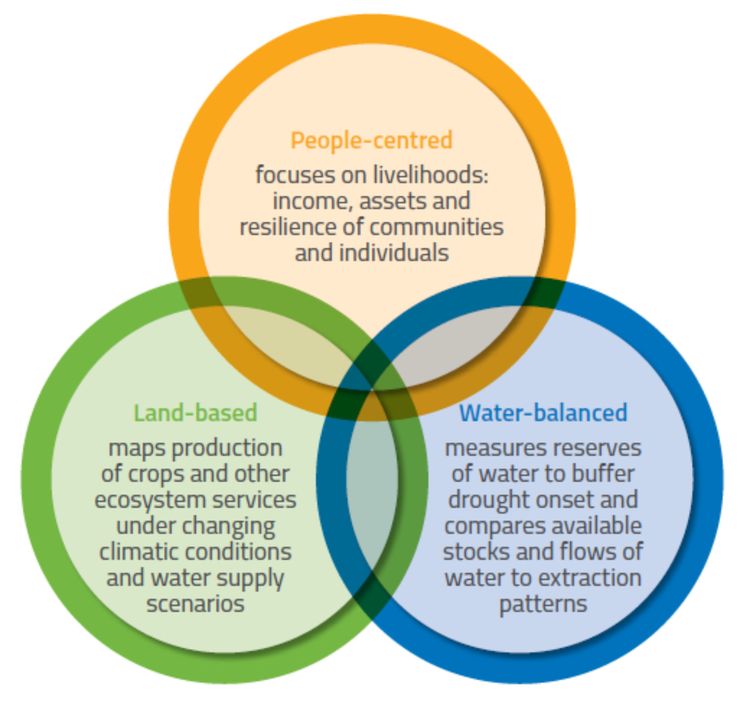
3. Identification of Equity Issues Within the Three Assessment Approaches
3.1. Ecosystem-Based Mapping and Modelling: Examples from Latin America and the Sahel
3.2. People-Centred Livelihoods Assessment Approaches: Examples from the Horn of Africa
3.3. Basin or Catchment Level Resource Accounting: Examples from India
4. Discussion
5. Conclusions
Author Contributions
Funding
Acknowledgments
Conflicts of Interest
Appendix A
References
- IPCC. Global Warming of 1.5 °C—Summary for Policymakers; Intergovernmental Panel on Climate Change: Geneva, Switzerland, 2018; p. 33. [Google Scholar]
- IPCC. Climate Change and Land—An IPCC Special Report on Climate Change, Desertification, Land Degradation, Sustainable Land Management, Food Security, And Greenhouse Gas Fluxes in Terrestrial Ecosystems; Summary for Policymakers Intergovernmental Panel on Climate Change: Geneva, Switzerland, 2019; p. 32. [Google Scholar]
- WWAP. Leaving Noone Behind; World Water Assessment Programme (WWAP), UNESCO: Paris, France, 2019; p. 185. [Google Scholar]
- GFDRR. Post-Disaster Needs Assessment Guidelines, Volume A; Global Facility for Disaster Reduction and Recovery: Washington DC, USA, 2013; p. 126. [Google Scholar]
- Jeggle, T.; Boggero, M. Lessons from a Decade of Experience: Post-Disaster Needs Assessment PDNA; European Commission (EU), Global Facility for Disaster Reduction and Recovery (GFDRR), the World Bank, and United Nations Development Program (UNDP): Washington, DC, USA, 2018; p. 72. [Google Scholar]
- Venton, P.A.; Venton, C.C.; Limones, N.; Ward, C.; Pischke, F.; Engle, N.L.; Wijnen, M.M.P.; Talbi, A. Framework for the Assessment of Benefits of Action or Cost of Inaction (BACI) for Drought Preparedness (English); World Bank Group: Washington, DC, USA, 2019; p. 61. [Google Scholar]
- IPCC. Annex II: Glossary. In Climate Change 2014: Impacts, Adaptation, and Vulnerability; Agard, J., Schipper, L., Eds.; Cambridge University Press: New York, NY, USA, 2014; pp. 1757–1776. [Google Scholar]
- Blauhut, V.; Stahl, K.; Stagge, J.H.; Tallaksen, L.M.; Stefano, L.D.; Vogt, J. Estimating drought risk across Europe from reported drought impacts, drought indices, and vulnerability factors. Hydrol. Earth Syst. Sci. 2016, 20, 2779–2800. [Google Scholar] [CrossRef]
- Kreibich, H.; Blauhut, V.; Aerts, J.C.J.H.; Bouwer, L.; Van Lanen, H.A.J.; Mejia, A.; Mens, M.; Van Loon, A.F. What Approaches and Data Are Needed to Better Understand Trends in Drought and Flood Impacts? In Proceedings of the 20th EGU General Assembly, EGU2018, Vienna, Australia, 4–13 April 2018; p. 10871. [Google Scholar]
- King-Okumu, C. Drought Impact & Vulnerability Assessment: A Rapid Review of Practices and Policy Recommendations; UNCCD: Bonn, Germany, 2019; p. 65. [Google Scholar]
- Crossman, N.D. Drought Resilience, Adaptation and Management Policy (DRAMP) Framework: Supporting Technical Guidelines; UNCCD: Bonn, Germany, 2018; p. 58. [Google Scholar]
- UNDRR. Global Assessment Report on Disaster Risk Reduction; UN office for Disaster Risk Reduction (DRR): Geneva, Switzerland, 2019; p. 472. [Google Scholar]
- UNISDR. Living with Risk: A Global Review of Disaster Reduction Initiatives; United Nations International Strategy for Disaster Reduction: Geneva, Switzerland, 2004. [Google Scholar]
- UNISDR. Drought Risk Reduction Framework and Practices: Contributing to the Implementation of the Hyogo Framework for Action; Technical Report; United Nations International Strategy for Disaster Reduction (UNISDR): Geneva, Switzerland, 2009; p. 213. [Google Scholar]
- UNISDR. Report of the Open-Ended Intergovernmental expert Working Group on Indicators and Terminology Relating to Disaster Risk Reduction; United Nations Office for Disaster Risk Reduction (UNISDR) & United Nations General Assembly (UNGA): New York, NY, USA, 2017; p. 41. [Google Scholar]
- IPCC. Annex 1—Glossary. In IPCC Special Report on Climate Change, Desertification, Land Degradation, Sustainable Land Management, Food Security, and Greenhouse gas fluxes in Terrestrial Ecosystems; IPCC: Geneva, Switzerland, 2019; p. 28. [Google Scholar]
- Critchley, W.R.S. Inquiry, initiative and inventiveness: Farmer innovators in East Africa. Phys. Chem. Earth Part B Hydrol. Ocean. Atmos. 2000, 25, 285–288. [Google Scholar] [CrossRef]
- Chambers, R.; Pacey, A.; Thrupp, L.A. (Eds.) Farmer First: Farmer Innovation and Agricultural Research; Intermediate Technology Publications: London, UK, 1989. [Google Scholar]
- King-Okumu, C.; Jillo, B.; Kinyanjui, J.; Jarso, I. Devolving water governance in the Kenyan Arid Lands: From top-down drought and flood emergency response to locally driven water resource development planning. Int. J. Water Resour. Dev. 2018, 34, 675–697. [Google Scholar] [CrossRef]
- Satapathy, S.; Porsché, I.; Rolker, D.; Bhatt, S.; Tomar, S.; Nair, S. (Eds.) A Framework for Climate Change Vulnerability Assessments; GIZ: Bonn, Germany, 2014; p. 186. [Google Scholar]
- Hagenlocher, M.; Meza, I.; Anderson, C.C.; Min, A.; Renaud, F.G.; Walz, Y.; Siebert, S.; Sebesvari, Z. Drought vulnerability and risk assessments: State of the art, persistent gaps, and research agenda. Environ. Res. Lett. 2019, 14, 083002. [Google Scholar] [CrossRef]
- Parry, M.L.; Carter, T.; Konijn, N. (Eds.) The Impact of Climatic Variations on Agriculture, Volume 2: Assessments in Semi-Arid Regions; Kluwer Academic Publishers for The International Institute for Applied Systems Analysis, United Nations Environment Program: Dordrecht, The Netherlands, 1988. [Google Scholar]
- CARE. Practical Guide to PSP: Participatory Scenario Planning Using Seasonal Forecasts; CARE Climate change, Agricultural Sector Development Support Programme (ASDSP), MoALF; Kenya Meteorological Department (KMD): Nairobi, Kenya, 2017; p. 144. [Google Scholar]
- CARE. Planning for Resilience A Practitioner’s Manual to Support Community Based Adaptation to Climate Change; CARE in Vietnam: Hanoi, Vietnam, 2015. [Google Scholar]
- CARE. Decision-Making for Climate Resilient Livelihoods and Risk Reduction: A Participatory Scenario Planning Approach; Adaptation Learning Programme: Nairobi, Kenya, 2012; p. 12. [Google Scholar]
- Boultif, M.; Benmessaoud, H. Using climate-soil-socioeconomic parameters for a drought vulnerability assessment in a semi-arid region: Application at the region of El Hodna, (M’sila, Algeria). Geogr. Pannon. 2017, 21, 142–150. [Google Scholar] [CrossRef]
- Kamali, B.; Abbaspour, K.C.; Wehrli, B.; Yang, H. Drought vulnerability assessment of maize in Sub-Saharan Africa: Insights from physical and social perspectives. Global Planet. Change 2018, 162, 266–274. [Google Scholar] [CrossRef]
- WMO/GWP. National Drought Management Policy Guidelines: A Template for Action (D.A. Wilhite). In Integrated Drought Management Program (IDMP) Tools and Guidelines, Series 1; WMO: Geneva, Switzerland; GWP: Stockholm, Sweden, 2014. [Google Scholar]
- IBRD. Toward Integrated Disaster Risk Management in Vietnam Recommendations Based on the Drought and Saltwater Intrusion Crisis and the Case for Investing in Longer-Term Resilience; The World Bank: Washington, DC, USA, 2017; p. 35. [Google Scholar]
- Meza-González, R.A.; Ibáñez-Hernández, O.F. Análisis de propuestas metodológicas sobre vulnerabilidad contenidas en los Programas de Medidas Preventivas y de Mitigación de la Sequía en México. Tecnociencia Chihuahua 2016, 9, 180–191. [Google Scholar]
- Ortega-Gaucin, D.; Bartolón, J.C.; Bahena, H.V.C. Drought vulnerability indices in Mexico. Water (Switzerland) 2018, 10, 1671. [Google Scholar] [CrossRef]
- Ortega-Gaucin, D.; Bartolón, J.d.l.C.; Bahena, H.V.C. 5. Peligro, Vulnerabilidad Y Riesgo Por Sequía En El Contexto Del Cambio Climático En México 80. In Agua Y Cambio Climático; Sánchez, R.L., Canales, A.A.P., Eds.; Instituto Mexicano de Tecnología del Agua: Jiutepec, Mexico, 2018; pp. 80–105. [Google Scholar]
- UNGRD. Seasonal Drought Outlook Strategies for Appropriate and Timely Decision-Making in Agriculture and Water Resources; National Unit for Disaster Risk Management: Bogotá, DC, USA, 2017; p. 33. [Google Scholar]
- Bank, W. Assessing Drought Hazard and Risk: Principles and Implementation Guidance; World Bank: Washington, DC, USA, 2019; p. 88. [Google Scholar]
- Ebi, K.L.; Padgham, J.; Doumbia, M.; Kergna, A.; Smith, J.; Butt, T.; McCarl, B. Smallholders adaptation to climate change in Mali. Clim. Change 2011, 108, 423–436. [Google Scholar] [CrossRef]
- Venton, C.C. Economics of Resilience to Drought; USAID: Washington, DC, USA, 2018; p. 43. [Google Scholar]
- Venton, C.C.; Fitzgibbon, C.; Shitarek, T.; Coulter, L.; Dooley, O. The Economics of Early Response and Disaster Resilience: Lessons from Kenya and Ethiopia; DFID: London, UK, 2012; p. 84. [Google Scholar]
- IUCN. Fp113: Twende: Towards Ending Drought Emergencies: Ecosystem Based Adaptation in Kenya’s Arid and SemiArid Rangelands; IUCN ESARO/GCF Documentation: Nairobi, Kenya, 2019; p. 79. [Google Scholar]
- PDNA. Kenya Post-Disaster Needs Assessment (PDNA) for the 2008-2011 Drought; Republic of Kenya with technical support from the European Union, United Nations, and World Bank and financial support from the European Union and the Grand Duchy of Luxembourg: Luxembourg, 2012; p. 188.
- Behnke, R.; Muthami, D. The Contribution of Livestock to the Kenyan Economy; IGAD Livestock Policy Initiative: Addis Ababa, Ethiopia, 2011; p. 62. [Google Scholar]
- NDMA. National Drought Management Authority Strategic Plan, 2018–2022; National Drought Management Authority, Government of Kenya: Nairobi, Kenya, 2018; p. 72.
- King-Okumu, C.; Orindi, V.A.; Lekalkuli, L. Drought Management in the Drylands of Kenya: What Have We Learned. In Drought Preparedness and Livelihood Implications in Developing Countries: What Are the Options? Mapedza, E., Tsegai, D., Bruentrup, M., McLeman, R., Eds.; Elsevier: Amsterdam, The Netherlands, 2019. [Google Scholar]
- IGAD. Mid-Term Review (MTR) of the 1st Phase, 2013–2017, of Implementation of the IGAD Drought Disaster Resilience and Sustainability Initiative (IDDRSI) Strategy; Intergovernmental Authority on Development: Djibouti City, Djibouti, 2016; p. 36. [Google Scholar]
- Metaferia. Productive Safety Net Program (Apl Iii) Final Report Consulting Services for Conducting Productive Safety Net Program 2ND 2011 Public Works Impact Assessment Credit; Metaferia: Addis Ababa, Ethiopia, 2013; p. 128. [Google Scholar]
- Siedenburg, J. Community-based Cost Benefit Analysis (CBCBA); Findings from DFID Kenya’s Arid Lands Support Programme Landell Mills: London, UK, 2016; p. 62. [Google Scholar]
- FAO. Boosting Emergency Drought Response in Kenya. Available online: http://www.fao.org/resilience/news-events/detail/en/c/1027789/ (accessed on 21 May 2018).
- King-Okumu, C. Distilling the Value of Water Investments; IIED: London, UK, 2016; p. 2. [Google Scholar]
- King-Okumu, C. Rapid Assessment of Investments in Natural Resource Stewardship in Comparison to the Value of Returns; International Institute for Environment and Development (IIED): London, UK, 2015. [Google Scholar]
- Taye, M.T.; Dyer, E.; Hirpa, F.A.; Charles, K. Climate change impact on water resources in the Awash basin, Ethiopia. Water (Switzerland) 2018, 10, 1560. [Google Scholar] [CrossRef]
- Hirpa, F.A.; Dyer, E.; Hope, R.; Olago, D.O.; Dadson, S.J. Finding sustainable water futures in data-sparse regions under climate change: Insights from the Turkwel River basin, Kenya. J. Hydrol. Reg. Stud. 2018, 19, 124–135. [Google Scholar] [CrossRef]
- Mutiga, J.K.; Mavengano, S.T.; Zhongbo, S.; Woldai, T.; Becht, R. Water Allocation as a Planning Tool to Minimise Water Use Conflicts in the Upper Ewaso Ng’iro North Basin, Kenya. Water Resour. Manag. 2010, 24, 3939–3959. [Google Scholar] [CrossRef]
- Silvestri, S.; Zaibet, L.; Mohammed Yahya Said; Shem Chege Kifugo, S.C. Valuing ecosystem services for conservation and development purposes: A case study from Kenya. Environ. Sci. Policy 2013, 31, 23–33. [Google Scholar] [CrossRef]
- Pandey, R.P.; Pandey, A.; Galkate, R.V.; Byun, H.R.; Mal, B.C. Integrating Hydro-Meteorological and Physiographic Factors for Assessment of Vulnerability to Drought. Water Resour. Manag. 2010, 24, 4199–4217. [Google Scholar] [CrossRef]
- He, X.; Wada, Y.; Wanders, N.; Sheffield, J. Intensification of hydrological drought in California by human water management. Geophys. Res. Lett. 2017, 44, 1777–1785. [Google Scholar] [CrossRef]
- SEEA, U.N. Statistical Papers Series M No. 91 International Recommendations for Water Statistics; Department of Economic and Social Affairs Statistics Division: New York, NY, USA, 2012; p. 213. [Google Scholar]
- Pedro-Monzonís, M.; Solera, A.; Ferrer, J.; Andreu, J.; Estrela, T. Water accounting for stressed river basins based on water resources management models. Sci. Total Environ. 2016, 565, 181–190. [Google Scholar] [CrossRef]
- SEEA, U.N. Seea Technical Note: Water Accounting Version: 27 October 2017; UN System for Environmental Economic Accounting: New York, NY, USA, 2017; p. 28. [Google Scholar]
- UNWater. Integrated Monitoring Guide for SDG 6 Step-By-Step Monitoring Methodology for Indicator 6.4.2 on Water Stress; FAO: Rome, Italy, 2017; p. 11. [Google Scholar]
- GoI. Manual for Drought Management; Government of India, Department of Agriculture, Cooperation & Farmers Welfare Ministry of Agriculture & Farmers Welfare: New Delhi, India, 2016; p. 167.
- Ashish, S. Drought management policy of india: An overview. Disaster Adv. 2019, 12, 51–62. [Google Scholar]
- Shah, A.; Mathur, N. Contestations around water allocation during a climate crisis in India: The case of ‘IPL vs. drought’. Global Environ. Change 2019, 57, 101927. [Google Scholar] [CrossRef]
- Pathak, S.; Garg, R.D.; Jato-Espino, D.; Lakshmi, V.; Ojha, C.S.P. Evaluating hotspots for stormwater harvesting through participatory sensing. J. Environ. Manag. 2019, 242, 351–361. [Google Scholar] [CrossRef]
- Kuchimanchi, B.R.; Nazareth, D.; Bendapudi, R.; Awasthi, S.; D’Souza, M. Assessing differential vulnerability of communities in the agrarian context in two districts of Maharashtra, India. Clim. Dev. 2019, 11, 918–929. [Google Scholar] [CrossRef]
- Ercin, E.; Chico, D.; Chapagain, A.K. Vulnerabilities of the European Union’s economy to hydrological extremes outside its borders. Atmosphere 2019, 10, 593. [Google Scholar] [CrossRef]
- Tanner, T.; Rentschler, J.; Surminski, S.; Mitchell, T.; Mechler, R.; Wilkinson, E.; Peters, K.; Reid, R.; Brandon, C.; Hallegatte, S.; et al. Unlocking the Triple Dividend of Resilience: Why Investing in Disaster Risk Management Pays off; ODI: London, UK, 2015; p. 24. [Google Scholar]
- Hallegatte, S.; Vogt-Schilb, A.; Bangalore, M.; Rozenberg, J. Unbreakable: Building the Resilience of the Poor in the Face of Natural Disasters; World Bank: Washington, DC, USA, 2017; p. 201. [Google Scholar]
- Dazé, A.; Ambrose, K.; Ehrhart, C. Climate Vulnerability and Capacity Analysis Handbook; CARE International: Chatelaine, Switzerland, 2009; p. 52. [Google Scholar]
- PROVIA. PROVIA Guidance on Assessing Vulnerability, Impacts and Adaptation to Climate Change; Consultation document; United Nations Environment Programme: Nairobi, Kenya, 2013; p. 198. [Google Scholar]
- Swiderska, K.; King-Okumu, C.; Islam, M.M. Ecosystem-Based Adaptation: A Handbook; IIED, UNEP/EbA South: London, UK, 2018. [Google Scholar]
- Burns, D.; Harvey, B.; Aragón, A.O. Introduction: Action Research for Development and Social Change. IDS Bull. 2012, 43, 1–7. [Google Scholar] [CrossRef][Green Version]
- Taylor, J.; Lassa, J.A. How Can Climate Change Vulnerability Assessments Best Impact Policy And Planning? Lessons from Indonesia International Institute for Environment and Development: London, UK, 2015; p. 33. [Google Scholar]
- Hovland, I. Successful Communication: A Toolkit for Researchers and Civil Society Organisations; Research and Policy in Development Programme, Overseas Development Institute: London, UK, 2005; p. 78. [Google Scholar]
- Jarso, I.; Tari, D.; King-Okumu, C. Recommendations to the County Government of Isiolo for Preparation of A Strategic Plan on Water, Energy and Climate Change; IIED: London, UK, 2017; p. 62. [Google Scholar]
- ChristianAid. Christian Aid Good Practice Guide: Participatory Vulnerability and Capacity Assessments (PVCA); ChristianAid: London, UK, 2009. [Google Scholar]
- Chiwaka, E.; Yates, R. Participatory Vulnerability Analysis: A Step-by-step Guide for Field Staff; ActionAid International: London, UK, 2005; p. 35. [Google Scholar]
- Macchi, M. Framework for Community-Based Climate Vulnerability and Capacity Assessment in Mountain Areas; International Centre for Integrated Mountain Development: Kathmandu, Nepal, 2011; p. 27. [Google Scholar]
- PracticalAction. Participatory Climate Risk Vulnerability and Capacity Assessment (PCR-VCA): Tools for Operationalizing the Adaptive Livelihood Framework; Practical Action: Colombo, Sri Lanka, 2012; p. 4. [Google Scholar]
- IFRC. How to Do a VCA: A Practical Step-by-step Guide for Red Cross Red Crescent Staff and Volunteers; International Federation of Red Cross and Red Crescent Societies: Geneva, Switzerland, 2007; p. 96. [Google Scholar]
- IFRC. What is VCA? An Introduction to Vulnerability and Capacity Assessment; International Federation of Red Cross and Red Crescent Societie IFRC: Geneva, Switzerland, 2006. [Google Scholar]
- NEF. Counting on Uncertainty—The economic case for community based adaptation in North-East Kenya Technical Appendices 1–9 July 2012; New Economics Foundation & CARE International: London, UK, 2012; p. 73. [Google Scholar]
- NEF. Counting on Uncertainty: The Economic Case for Community based Adaptation in North-East Kenya; New Economics Foundation & CARE International: London, UK, 2012; p. 48. [Google Scholar]
- Oliver, S.; Rossing, T.; Cross, K. Assessing climate change vulnerability in East Africa: A case study on the use of CARE’s Climate Change Vulnerability and Capacity Assessment (CVCA) methodology within the Global Water Initiative East Africa Program; CARE USA, CARE International, International Union for Conservation of Nature (IUCN): Nairobi, Kenya, 2011. [Google Scholar]
- IFRC. Ethiopian Droughts: Reducing the Risk to Livelihoods Through Cash Transfer; International Federation of the Red Cross (IFRC): Geneva, Switzerland; Addis Ababa, Ethiopia, 2003. [Google Scholar]
- IFRC. Using the Vulnerability and Capacity Assessment Tool in Rwanda; International Federation of Red Cross and Red Crescent Societies: Geneva, Switzerland, 2003; p. 20. [Google Scholar]
- IBRD. Participatory Scenario Development Approaches for Identifying Pro-Poor Adaptation Options; Capacity Development Manual World Bank: Washington, DC, USA, 2010; p. 90. [Google Scholar]


| Approach | Characterization of Approach | Strengths | Weaknesses |
|---|---|---|---|
| People-centred | Focuses on people, their assets and ability to recover from drought | Ensures people-centered analysis, broader than income only Includes presentation of economic case at household level Can accommodate long-term time horizon Considers capacities of different kinds Familiar to practitioners. Connects to agro-ecosystems | Data-intensive and time consuming Focuses on household scale—may not be multiscale May not capture effects on the national and regional economy Can favor recommendations to diversify the livelihood portfolio Can miss effects that deepen long term systemic vulnerability Often misses identification of strategic water management solutions |
| Land or ecosystem-based | Focuses on ecosystems, their productivity and responses to climate anomalies | Ensures coverage of resource-dependent production systems Can connect to climate models and to economic models Can be mapped and monitored at low cost using satellite derived data Many agricultural adaptation options likely to be identified Familiar to agricultural extension systems and capacities in place | Inclusion of poor and marginal groups not always systematic More oriented to agriculture than other sectors May not capture vulnerabilities in urban areas Not necessarily long term Focuses on field scale—may not be multiscale May have relatively short time horizons Does not consider water needs in other sectors of the economy |
| Water balanced | Focuses on water availability, and relation to demands from different sectors of the economy, management systems and hydro-climatic cycles | Considers water availability and demand across the economy including in urban areas Makes effective use of climate models and scenarios Connects to drought monitoring and early warning systems Can enable identification of capacity needs Can enable identification of risk management actions | Institutional challenges to coordinate data collection, management and analysis Data on water extractions often incomplete in drought-affected areas May require information on groundwater management Municipal and industrial water extractions growing faster and less well understood than agricultural water use Transboundary issues, political and security sensitivities in some countries |
© 2020 by the authors. Licensee MDPI, Basel, Switzerland. This article is an open access article distributed under the terms and conditions of the Creative Commons Attribution (CC BY) license (http://creativecommons.org/licenses/by/4.0/).
Share and Cite
King-Okumu, C.; Tsegai, D.; Pandey, R.P.; Rees, G. Less to Lose? Drought Impact and Vulnerability Assessment in Disadvantaged Regions. Water 2020, 12, 1136. https://doi.org/10.3390/w12041136
King-Okumu C, Tsegai D, Pandey RP, Rees G. Less to Lose? Drought Impact and Vulnerability Assessment in Disadvantaged Regions. Water. 2020; 12(4):1136. https://doi.org/10.3390/w12041136
Chicago/Turabian StyleKing-Okumu, Caroline, Daniel Tsegai, Rajendra Prasad Pandey, and Gwyn Rees. 2020. "Less to Lose? Drought Impact and Vulnerability Assessment in Disadvantaged Regions" Water 12, no. 4: 1136. https://doi.org/10.3390/w12041136
APA StyleKing-Okumu, C., Tsegai, D., Pandey, R. P., & Rees, G. (2020). Less to Lose? Drought Impact and Vulnerability Assessment in Disadvantaged Regions. Water, 12(4), 1136. https://doi.org/10.3390/w12041136