Impact of Extreme Drought Climate on Water Security in North Borneo: Case Study of Sabah

 ,
,  ,
,
Abstract
1. Introduction
2. Materials and Methods
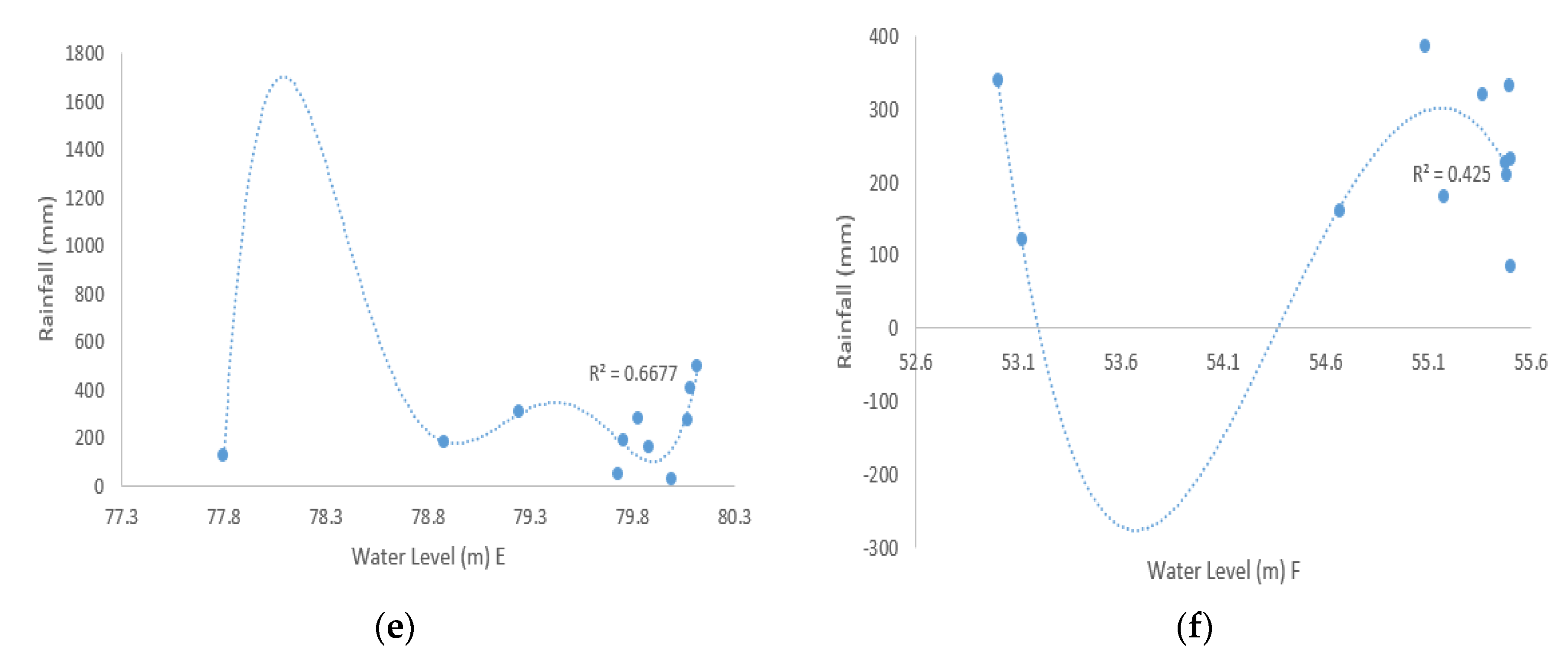
2.1. Study Area
2.2. Dam Water Level and Rainfall Analysis
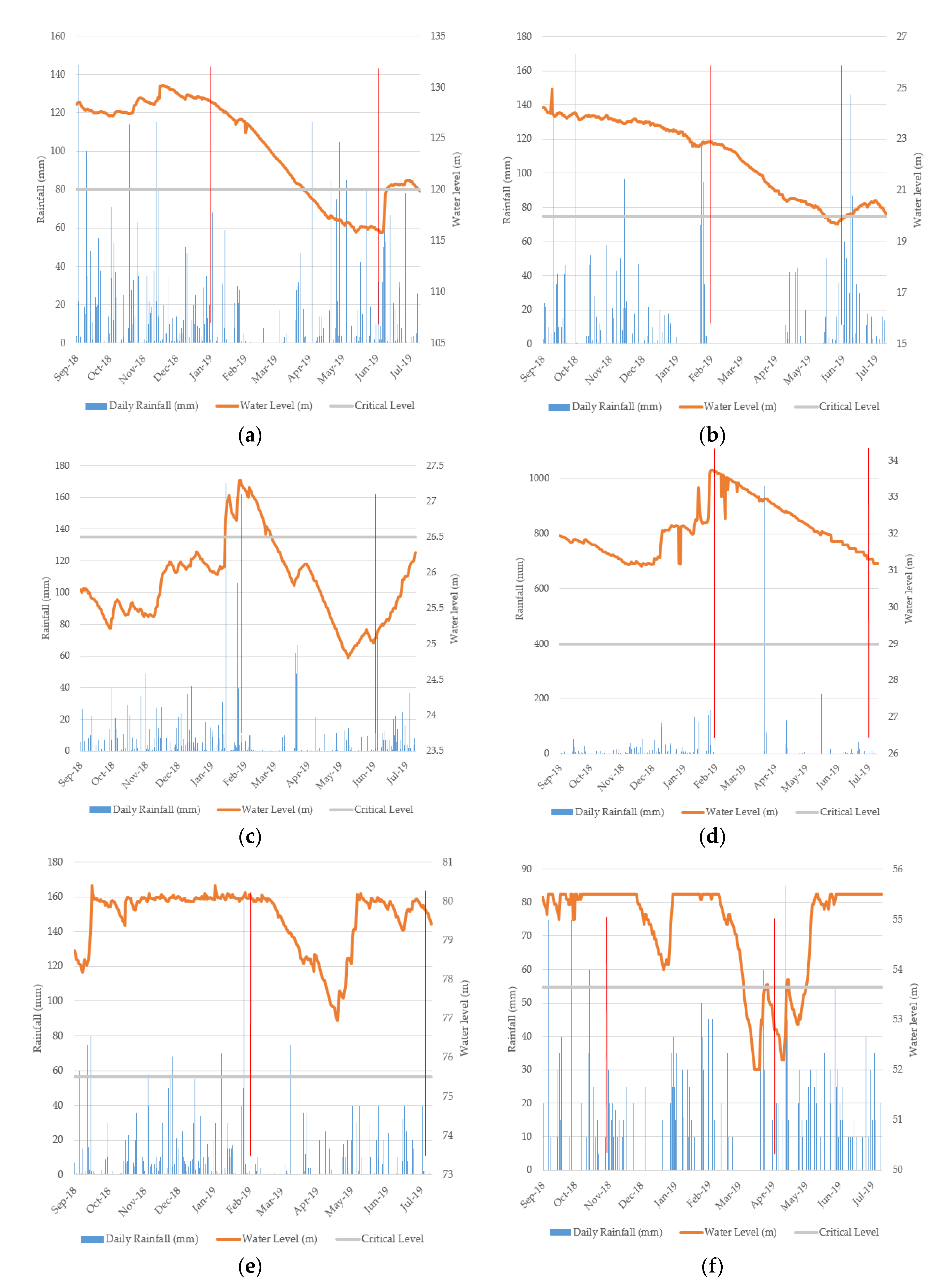
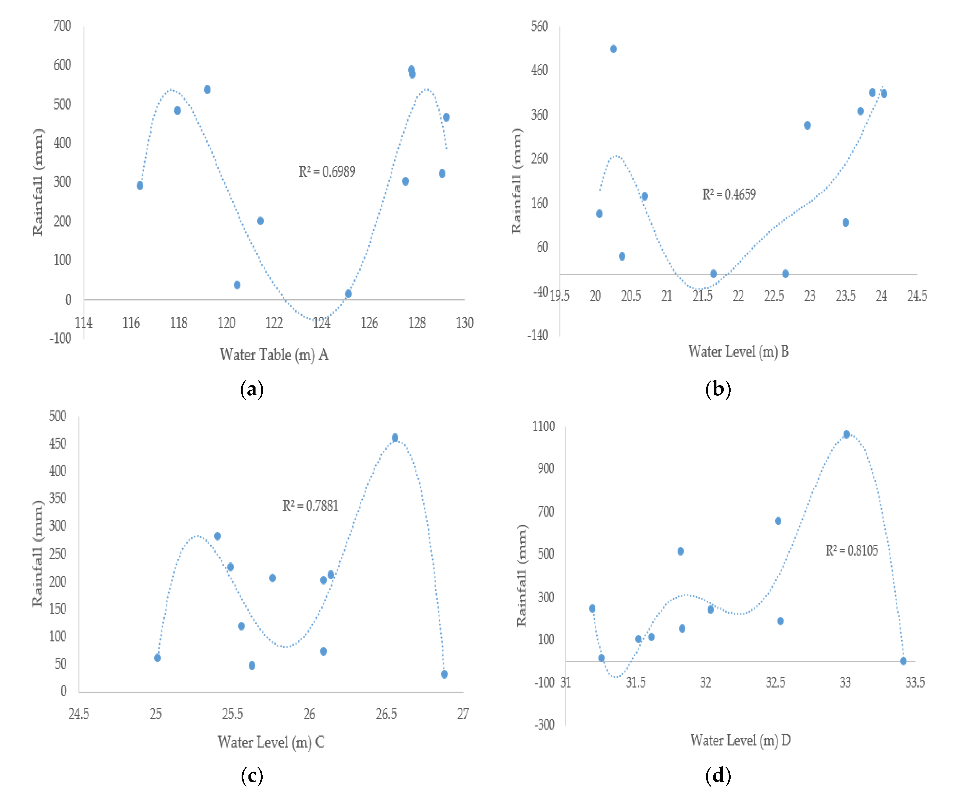
3. Results and Discussions
- Dam C (Betotan, North East Coast of Borneo)
- Dam A (Babagon, West Coast of Borneo)
- Dam F (Timbangan, South East Coast of Borneo)
- Dam B (Telibong II, West Coast of Borneo)
- Dams D and E (Milau and Sepagaya, North and South East of Borneo)
4. Conclusions
Author Contributions
Funding
Acknowledgments
Conflicts of Interest
References
- Warner, J.; Johnson, C.L. Virtual water, real people: Useful concept or prescriptive tool? Water Int. 2007, 32, 63–77. [Google Scholar] [CrossRef]
- FAO. Climate Change, Water and Food Security; Food and Agriculture Organization of the United Nations: Rome, Italy, 2011. [Google Scholar]
- Zhang, Q.; Sun, P.; Li, J.; Xiao, M.; Singh, V.P. Assessment of drought vulnerability of the Tarim River basin, Xinjiang, China. Theor. Appl. Climatol. 2014, 121, 337–347. [Google Scholar] [CrossRef]
- Mohammad, A.H.; Jung, H.C.; Odeh, T.; Bhuiyan, C.; Hussein, H. Understanding the impact of drought in the Yarmouk Basin, Jordan: Monitoring droughts through meteorological and hydrological drought indices. Arab. J. Geosci. 2018, 11, 103. [Google Scholar] [CrossRef]
- Sindico, F. The Guarani aquifer system and the international law of transboundary aquifers. Int. Community Law Rev. 2011, 13, 255–272. [Google Scholar] [CrossRef]
- Cooley, H.; Christan-Smith, J.; Gleick, P.H.; Allen, L.; Cohen, M. Understanding and Reducing the Risks of Climate Change for Transboundary Waters; United Nations Environment Programme: New York, NY, USA, 2009. [Google Scholar]
- Gleick, P.H. How much water is there and whose is it? In The World’s Water 2000–2001: The Biennial Report on Freshwater Resources; Island Press: Washington, DC, USA, 2000. [Google Scholar]
- Gleick, P.H. Water and conflict. Int. Secur. 1993, 18, 79–112. [Google Scholar] [CrossRef]
- United Nations (UN). Integrated River Basin Development; UN Publications: New York, NY, USA, 1958. [Google Scholar]
- United Nations (UN). International Rivers; Pergamon Press: Oxford, UK, 1978. [Google Scholar]
- Wolf, A.T.; Natharius, J.; Danielson, J.; Ward, B.; Pender, J. International river basins of the world. Int. J. Water Resour. Dev. 1999, 15, 387–427. [Google Scholar] [CrossRef]
- UNESCO. Methodology for the Assessment of Transboundary Aquifers; UNEP: Nairobi, Kenya, 2009. [Google Scholar]
- Da Silva, L.P.B.; Hussein, H. Production of scale in regional hydropolitics: An analysis of La Plata River Basin and the Guarani Aquifer System in South America. Geoforum 2019, 99, 42–53. [Google Scholar] [CrossRef]
- Villar, P.C. International cooperation on transboundary aquifers in South America and the Guarani Aquifer case. Revita Bras. De Politica Int. 2016, 59, 1609. [Google Scholar] [CrossRef]
- Gun, J.V.C. The Agriculture Groundwater Revolution: Opportunities and Threats to Development; Cromwell Press: Trowbridge, UK, 2007. [Google Scholar]
- UNESCO. Atlas of Transboundary Aquifers: Global Maps, Regional Cooperation and Local Inventories; UNESCO: Paris, France, 2007. [Google Scholar]
- Cassuto, D.; Samppaio, R.S.R. Hard, soft & uncertain: The Guarani aquifer and the challenges of transboundary groundwater. Colo. Nat. Resour. Energy Environ. Law Rev. 2013, 24, 1–42. [Google Scholar]
- Kristin, E.J.; Ashton, P.J. Adapting to change in transboundary rivers: An analysis of treaty flexibility on the Orange-Senqu River Basin. Int. J. Water Resour. Dev. 2008, 24, 385–400. [Google Scholar] [CrossRef]
- Goldenman, G. Adapting to climate change: A study of international rivers and their legal arrangements. Ecol. Law Q. 1990, 17, 741–802. [Google Scholar]
- McCaffrey, S.C. The need for flexibility in freshwater treaty regimes. Nat. Resour. Forum 2003, 27, 156–162. [Google Scholar] [CrossRef]
- Fischhendler, I. Legal and institutional adaptation to climate uncertainty: A study of international rivers. Water Policy 2004, 6, 281–302. [Google Scholar] [CrossRef]
- Hussein, H. The Guarani Aquifer System, highly present but not high profile: A hydropolitical analysis of transboundary groundwater governance. Environ. Sci. Policy 2018, 83, 54–62. [Google Scholar] [CrossRef]
- Cooley, H.; Gleick, P.H. Climate-proofing transboundary water agreements. Hydrol. Sci. J. 2011, 56, 711–718. [Google Scholar] [CrossRef]
- Kundzewicz, Z.W.; Mata, L.J.; Arnell, N.W.; Doll, P.; Jimenez, B.; Miller, K.; Oki, T.; Sen, Z.; Shiklomanov, I. The implications of projected climate change for freshwater resources and their management. Hydrol. Sci. J. 2008, 53, 3–10. [Google Scholar] [CrossRef]
- IPCC. Climate Change 2014: Synthesis Report; Contribution of Working Groups I, II and III to the Fifth Assessment Report of the Intergovernmental Panel on Climate Change; IPCC: Geneva, Switzerland, 2014. [Google Scholar]
- Kwan, M.S.; Tangang, F.; Liew, J. Projected changes of future climate extremes in Malaysia. Sains Malays. 2013, 42, 1051–1059. [Google Scholar]
- Chenoli, S.N.; Jayakrishnan, P.R.; Abu Samah, A.; Ooi, S.H.; Ahmad Mazuki, M.; Lim, C.H. Southwest monsoon onset dates over Malaysia and associated climatological characteristics. J. Atmos. Sol. Terr. Phys. 2018, 179, 81–93. [Google Scholar] [CrossRef]
- Ali Khan, M.M.; Shaari, N.; Achmad Nahar, A.; Baten, M.; Nazaruddin, D. Flood impact assessment in Kota Bharu, Malaysia: A statistical analysis. World Appl. Sci. J. 2014, 32, 626–634. [Google Scholar]
- Sammathuria, M.K.; Ling, L.K. Regional Climate Observation and Simulation of Extreme Temperature and Precipitation Trends. In Proceedings of the 14th International Rainwater Catchment Systems Conference, Kuala Lumpur, Malaysia, 3–6 August 2009. [Google Scholar]
- Abdulah, N.; Jusoh, J.; Kassim, A. Country Reports—Malaysia. Capacity Development to Support National Drought Management Policy; Integrated Drought Management Programme (IDMP): Hanoi, Vietnam, 2014. [Google Scholar]
- Alagesh, T.N. Sungai Tembeling drying up in heatwave. New Straits Times, 8 March 2019. [Google Scholar]
- NST. Dry weather to last until May; water shortage in 6 states. New Straits Times, 24 March 2019. [Google Scholar]
- Sim, L.L.; Chung, C.; Izahar, N. Too many unplanned water cuts. The Star, 3 August 2019. [Google Scholar]
- Tham, J.V. 7 Klang Valley Districts Will Face Water Cuts up to 84 Hours Next Week. Says, 16 July 2019. [Google Scholar]
- Boo, S.-L. Water cuts to hit Petaling Jaya. Malay Mail, 18 March 2019. [Google Scholar]
- Chu, M.M. Xavier: Longer droughts expected, Malaysia’s water industry in dire straits. The Star, 25 July 2019. [Google Scholar]
- Marcos-Garcia, P.; Lopez-Nicolas, A.; Pulido-Velazquez, M. Combined use of relative drought indices to analyze climate change impact on meteorological and hydrological droughts in a Mediterranean basin. J. Hydrol. 2017, 554, 292–305. [Google Scholar] [CrossRef]
- Smith, A.B.; Katz, R.W. US billion-dollar weather and climate disasters: Data sources, trends, accuracy and biases. Nat. Hazards 2013, 67, 387–410. [Google Scholar] [CrossRef]
- Zhang, Q.; Zhang, W.; Chen, Y.D.; Jiang, T. Flood, drought and typhoon disasters during the last half-century in the Guangdong province, China. Nat. Hazards 2011, 57, 267–278. [Google Scholar] [CrossRef]
- Abdul Rahman, H. Water Shortage in Malaysia: Again? Malays. Consum. Law J. 2014, 1, 115–128. [Google Scholar]
- Easterling, D.R.; Meehl, G.A.; Parmesan, C.; Changnon, S.A.; Karl, T.R.; Mearns, L.O. Climate extremes: Observations, modeling, and impacts. Science 2000, 289, 2068–2074. [Google Scholar] [CrossRef]
- Kua, K.S. Water crisis: The price of populism. The Star, 28 July 2019. [Google Scholar]
- Malay Mail. CM denies Melaka to declare emergency over water shortage. Malay Mail, 19 September 2019. [Google Scholar]
- Falkenmark, M.; Lindh, G. How can we cope with the water resources situation by the year 2015? AMBIO 1974, 3, 114–122. [Google Scholar]
- Falkenmark, M. Freshwater: Time for a modified approach. AMBIO 1986, 15, 192–200. [Google Scholar]
- Falkenmark, M. The massive water scarcity now threatening Africa: Why isn’t it being addressed? AMBIO 1989, 18, 112–118. [Google Scholar]
- Mehta, L. Whose scarcity? Whose property? The case of water in western India. Land Use Policy 2007, 24, 654–663. [Google Scholar] [CrossRef]
- Garreth, A.S.E. Justice, Neoliberal natures and Australia’s water reforms. Trans. Inst. Br. Geogr. 2015, 40, 479–493. [Google Scholar]
- Garreth, A.S.E. Shifting constructions of scarcity and the Neoliberalization of Australian water governance. Environ. Plan. A Econ. Space 2013, 45, 1873–1890. [Google Scholar]
- Garreth, A.S.E.; Bulkeley, H.A. Heterotopia and the urban politics of climate change experimentation. Environ. Plan. D Soc. Space 2018, 36, 350–369. [Google Scholar]
- Hussein, H. Lifting the veil: Unpacking the discourse of water scarcity in Jordan. Environ. Sci. Policy 2018, 89, 385–392. [Google Scholar] [CrossRef]
- Jeremy, A. The sustainability and resilience of global water and food systems: Political analysis of the interplay between security, resource scarcity, political systems and global trade. Food Policy 2011, 36, 3–8. [Google Scholar]
- Hussein, H. Whose ‘reality’? Discourses and hydropolitics along the Yarmouk River. Contemp. Levant J. 2017, 2, 103–115. [Google Scholar] [CrossRef]
- Hussein, H. Yarmouk, Jordan and Disi Basins: Examining the impact of the discourse of water scarcity in Jordan on transboundary water governance. Mediterr. Politics 2019, 24, 269–289. [Google Scholar] [CrossRef]
- Hussein, H.; Grandi, M. Dynamic political contexts and power asymmetries: The cases of the Blue Nile and the Yarmouk Rivers. Int. Environ. Agreem. Politics Law Econ. 2017, 17, 795–814. [Google Scholar] [CrossRef]
- Lankford, B.A. Resource Efficiency Complexity and the Commons: The Paracommons and Paradoxes of Natural Resources Losses, Wastes and Wastages; Earthscan Publications: Abingdon, UK, 2013. [Google Scholar]
- Zeitoun, M.; Lankford, B.; Bakker, K.; Conway, D. Water Security—Principles, Perspectives and Practices; Routledge: London, UK, 2013. [Google Scholar]
- Zeitoun, M. Power and Water in the Middle East: The Hidden Politics of the Palestinian-Israeli Water Conflict; I.B. Tauris Publications: London, UK; New York, NY, USA, 2008. [Google Scholar]
- Lankford, B.A. Resource centered thinking in river basins: Should we revoke the crop water requirement approach to irrigation planning? Agric. Water Manag. 2004, 68, 33–46. [Google Scholar] [CrossRef]
- Zeitoun, M. The global web of national water security. Glob. Policy 2011, 2, 286–296. [Google Scholar] [CrossRef]
- Cook, C.; Bakker, K. Water security: Debating an emerging paradigm. Glob. Environ. Chang. 2012, 22, 94–102. [Google Scholar] [CrossRef]
- Bakker, K. Privatizing Water: Governance Failure and the World’s Urban Water Crisis; Cornell University Press: Ithaca, NY, USA; London, UK, 2010. [Google Scholar]
- Ho, K.; Tang, D. Climate change in Malaysia: Trends, contributors, impacts, mitigation, and adaptations. Sci. Total Environ. 2019, 650, 1858–1871. [Google Scholar]
- Bernama. Water in six dams in Sabah may soon run out. New Straits Times, 5 March 2019. [Google Scholar]
- Miwil, O. With drying rivers, Sabah has just two months of water reserves. New Straits Times, 27 February 2019. [Google Scholar]
- Jiffar, S. Kota Belud declares drought. New Straits Times, 1 March 2019. [Google Scholar]
- Menga, F. Hydropolis: Reinterpreting the polis in water politics. Political Geogr. 2017, 60, 100–109. [Google Scholar] [CrossRef]
- Hussein, H.; Menga, F.; Greco, F. Monitoring transboundary water cooperation in SDG 6.5.2: How a critical hydropolitics approach can spot inequitable outcomes. Sustainability 2018, 10, 3640. [Google Scholar] [CrossRef]
- Ministry of Natural Resources and Environment Malaysia (MNRE). Malaysia Biennial Update Report to the UNFCC; Ministry of Natural Resources and Environment Malaysia: Putrajaya, Malaysia, 2015. [Google Scholar]
- Tang, A. Group: Nation not prepared for water crisis. The Star, 27 July 2019. [Google Scholar]
- Zack, J. Water disruption to hit more than 370,000 after pollution shuts down Selangor treatment plant. The Star, 28 September 2019. [Google Scholar]
- Che-Ani, A.I.; Shaari, N.; Sairi, A.; Zain, M.F.; Tahir, M.M. Rainwater harvesting as an alternative water supply in the future. Eur. J. Sci. Res. 2009, 34, 132–140. [Google Scholar]
- Ahmad, F.; Ushiyama, T.; Sayama, T. Determination of Z-R Relationship and Inundation Analysis for Kuantan River Basin; Malaysia Meteorological Department: Petaling Jaya, Malaysia, 2017. [Google Scholar]
- Odeh, T.; Mohammad, A.H.; Hussein, H.; Ismail, M.; Almomani, T. Over-pumping of groundwater in Irbid governorate, northern Jordan: A conceptual model to analyze the effects of urbanization and agricultural activities on groundwater levels and salinity. Environ. Earth Sci. 2019, 78, 40. [Google Scholar] [CrossRef]
- Odeh, T.; Salameh, E.; Schirmer, M.; Strauch, G. Structural control of groundwater flow regimes and groundwater chemistry along the lower reaches of the Zerka River, West Jordan, using remote sensing, GIS and field methods. Environ. Geol. 2009, 58, 1797–1810. [Google Scholar] [CrossRef]
- Odeh, T.; Rodiger, T.; Geyer, S.; Schirmer, M. Hydrological modeling of a heterogeneous catchment using an integrated approach of remote sensing, a geographic information system and hydrologic response units: The case study of Wadi Zerka Ma’inn catchment area, northeast of the Dead Sea. Environ. Earth Sci. 2015, 73, 3309–3326. [Google Scholar] [CrossRef]
- Baldock, J.; Bancrodt, K.P.; William, M.; Shedrawi, G.; Field, S. Accurately estimating local water temperature from remotely sensed satellite sea surface temperature: A near real-time monitoring tool for marine protected areas. Ocean Coast Manag. 2014, 96, 73–81. [Google Scholar] [CrossRef]
- Souza, C.R.G. Coastal erosion and the coastal zone management challenges in Brazil. J. Integr. Coast. Zone Manag. 2009, 9, 17–37. [Google Scholar]
- Yusof, K.M.; Azid, A.; Shirwan, M.A.S.; Samsudin, M.S.; Syuhada, M.A.; Nurul, L.A.; Jamalani, M.A. The evaluation on artificial neural networks (ANN) and multiple linear regression (MLR) models over particulate matter (PM10) variability during haze and non-haze episodes: A decade case study. Malays. J. Fundam. Appl. Sci. 2019, 15, 164–172. [Google Scholar] [CrossRef]
- Blunden, J.; Arndt, D.S.; Hartfield, G. State of the Climate in 2017. Bull. Am. Meteorol. Soc. 2018, 99, 1–310. [Google Scholar]
- El Jazouli, A.; Barakat, A.; Khellouk, R.; Rais, J.; El Baghdadi, M. Remote sensing and GIS techniques for prediction of land use land cover change effects on soil erosion in the high basin of the Oum Er Rabia River (Morocco). Remote Sens. Appl. Soc. Environ. 2019, 13, 361–374. [Google Scholar] [CrossRef]
- Gerlak, A.K.; House-Peters, L.; Varady, R.G.; Albrecht, T.; Zúñiga-Terán, A.; de Grenade, R.R.; Scott, C.A. Water security: A review of place-based research. Environ. Sci. Policy 2018, 82, 79–89. [Google Scholar] [CrossRef]
- Kao, S.C.; Govindaraju, S.R. A copula-based joint deficit index for droughts. J. Hydrol. 2010, 380, 121–134. [Google Scholar] [CrossRef]
- Lillesand, T.; Kiefer, R.W.; Chipman, J. Remote Sensing and Image Interpretation; John Wiley & Sons: Chichester, West Sussex, UK, 2014. [Google Scholar]
- Mekonnen, M.M.; Hoekstra, A.Y. Four billion people facing severe water scarcity. Sci. Adv. 2016, 2, 17–23. [Google Scholar] [CrossRef]
- Davey, M.K.; Anderson, D.L.T. A comparison of the 1997/98 El Nino with other such events. Weather 1998, 53, 295–310. [Google Scholar] [CrossRef]
- Wolter, K.; Timlin, M.S. Measuring the strength of ENSO events: How does 1997/98 rank. Weather 1998, 53, 315–324. [Google Scholar] [CrossRef]
- Walsh, R.P.D.; Newbery, D.M. The ecoclimatology of Danum, Sabah, in the context of the world’s rainforest regions, with particular reference to dry periods and their impact. Philos. Trans. R. Soc. 1999, 354, 1869–1883. [Google Scholar] [CrossRef]
- Johnson, J.A. Assessing the Impact of Climate Change in Borneo; World Wildlife Fund Environmental Economics Series; World Wildlife Fund: Washington, DC, USA, 2012. [Google Scholar]
- Rossi, G. Drought and Drought Mitigation in Europe; Kluwer Academic Publisher: Dordrecht, The Netherlands, 2000. [Google Scholar]
- Bhuiyan, C.; Singh, R.P.; Kogan, F.N. Monitoring drought dynamics in the Aravalli region (India) using different indices based on ground and remote sensing data. Int. J. Appl. Earth Obs. Geoinform. 2006, 8, 289–302. [Google Scholar] [CrossRef]
- Dracup, J.A.; Lee, K.S.; Paulson, E.G. On the definition of droughts. Water Resour. Res. 1980, 16, 297–302. [Google Scholar] [CrossRef]
- Jain, S.K.; Keshri, R.; Goswami, A.; Sarkar, A. Application of meteorological and vegetation indices for evaluation of drought impact: A case study for Rajasthan, India. Nat. Hazards 2010, 54, 643–656. [Google Scholar] [CrossRef]
- Bandyopadhyay, N.; Bhuiyan, C.; Saha, A.K. Heat waves, temperature extremes and their impacts on monsoon rainfall and meteorological drought in Gujarat, India. Nat. Hazards 2016, 82, 367–388. [Google Scholar] [CrossRef]
- Jones, R.; Chiew, F.; Boughton, W.; Zhang, L. Estimating the sensitivity of mean annual runoff to climate change using selected hydrological models. Adv. Water Resour. 2005, 29, 1419–1429. [Google Scholar] [CrossRef]
- Ho, M.U.; Lall, M.; Allaire, N.; Devineni, H.H.; Kwon, I.; Pal, D.; Wegner, D. The future role of dams in the United States of America. Water Resour. Res. 2017, 53, 982–998. [Google Scholar] [CrossRef]
- Barnett, T.P.; Adam, J.C.; Lettenmaier, D.P. Potential impacts of a warming climate on water availability in snow-dominated regions. Nature 2005, 438, 303–309. [Google Scholar] [CrossRef]
- Steinschneider, S.M.; Ho, E.; Cook, R.; Lall, U. Can PDSI inform extreme precipitation: An exploration with a 500-year long paleoclimate reconstruction over the U.S. Water Resour. Res. 2016, 52, 3866–3880. [Google Scholar] [CrossRef]
- Cook, E.R.; Seager, R.; Heim, R.; Vose, R.S.; Herweijer, C.; Woodhouse, C. Megadroughts in North America: Placing IPCC projections of hydroclimatic change in a long-term paleoclimate context. J. Q. Sci. 2010, 25, 48–61. [Google Scholar] [CrossRef]
- Russo, T.A.; Lall, U. Depletion and response of deep groundwater to climate-induced pumping variability. Nat. Geosci. 2017, 10, 105–108. [Google Scholar] [CrossRef]
- Pulido-Velazquez, M.; Marques, G.F.; Harou, J.J.; Lund, J.R. Integrated Groundwater Management: Concepts, Approaches and Challenges; Springer: Cham, Switzerland, 2016. [Google Scholar]
- Razman, M.R.; Payus, C.; Jahi, J.M. Control of river pollution in protecting ecology and human habitat: Legislative review in Malaysia. Int. J. Malay World Civiliz. 2010, 28, 227–240. [Google Scholar]


| Dam | ||||||
|---|---|---|---|---|---|---|
| Water Level Indicator | C | D | A | B | E | F |
| Number of days at good * level | 20 | 314 | 199 | 212 | 314 | 231 |
| Number of days at alert * level | 23 | 0 | 38 | 83 | 0 | 29 |
| Number of days at critical * level | 271 | 0 | 77 | 19 | 0 | 54 |
| Percentage of days at critical level | 86.31% | 0% | 24.52% | 6.05% | 0% | 17.20% |
| Dam | Risk Factors | ||
|---|---|---|---|
| Water Supply | Sensitivity to Rainfall | Impact of Drought | |
| C | - Very water-insecure - Below critical 86.31% of the time - Undersupply or overdemand | - High - Water level corresponds closely to rainfall frequency and intensity | - High - Significant net loss of water - Water levels fell to the lowest point during drought |
| A | - Slightly water-insecure - Water levels below critical 24.52% of the time (only during drought) | - Moderate - Water level unaffected by rainfall <60 mm and isolated heavy rainfall | - High - Water levels fell most sharply to critical during drought |
| F | - Slightly water-insecure - Water levels below critical17.20% of the time | - High - Changes in water level directly parallel to rainfall events | - High - Smaller capacity means less tolerance for drought events |
| B | - Mostly water-secure - Water levels below critical 6.05% of the time (only duringdrought) | - Low - Water level not particularly sensitive to rainfall | - Moderate - The water level did not sharply decrease during drought |
| E | - Water-secure - Water levels adequate to meet demand even through drought | - High - Changes in water level directly parallel to rainfall events | - Low - Smaller tolerance for drought events offset by adequacy of water supply |
| D | - Water-secure - Water levels adequate to meet demand even thoughdrought | - Moderate - Not particularly sensitive to rainfall | - Moderate - Water level decreased but not to a critical level |
© 2020 by the authors. Licensee MDPI, Basel, Switzerland. This article is an open access article distributed under the terms and conditions of the Creative Commons Attribution (CC BY) license (http://creativecommons.org/licenses/by/4.0/).
Share and Cite
Payus, C.; Ann Huey, L.; Adnan, F.; Besse Rimba, A.; Mohan, G.; Kumar Chapagain, S.; Roder, G.; Gasparatos, A.; Fukushi, K. Impact of Extreme Drought Climate on Water Security in North Borneo: Case Study of Sabah. Water 2020, 12, 1135. https://doi.org/10.3390/w12041135
Payus C, Ann Huey L, Adnan F, Besse Rimba A, Mohan G, Kumar Chapagain S, Roder G, Gasparatos A, Fukushi K. Impact of Extreme Drought Climate on Water Security in North Borneo: Case Study of Sabah. Water. 2020; 12(4):1135. https://doi.org/10.3390/w12041135
Chicago/Turabian StylePayus, Carolyn, Lim Ann Huey, Farrah Adnan, Andi Besse Rimba, Geetha Mohan, Saroj Kumar Chapagain, Giulia Roder, Alexandros Gasparatos, and Kensuke Fukushi. 2020. "Impact of Extreme Drought Climate on Water Security in North Borneo: Case Study of Sabah" Water 12, no. 4: 1135. https://doi.org/10.3390/w12041135
APA StylePayus, C., Ann Huey, L., Adnan, F., Besse Rimba, A., Mohan, G., Kumar Chapagain, S., Roder, G., Gasparatos, A., & Fukushi, K. (2020). Impact of Extreme Drought Climate on Water Security in North Borneo: Case Study of Sabah. Water, 12(4), 1135. https://doi.org/10.3390/w12041135