Assessment of the Geo-Environmental Status of European Union Priority Habitat Type “Mediterranean Temporary Ponds” in Mt. Oiti, Greece

 ,
, 
 ,
,  ,
,
Abstract

1. Introduction
2. Materials and Methods
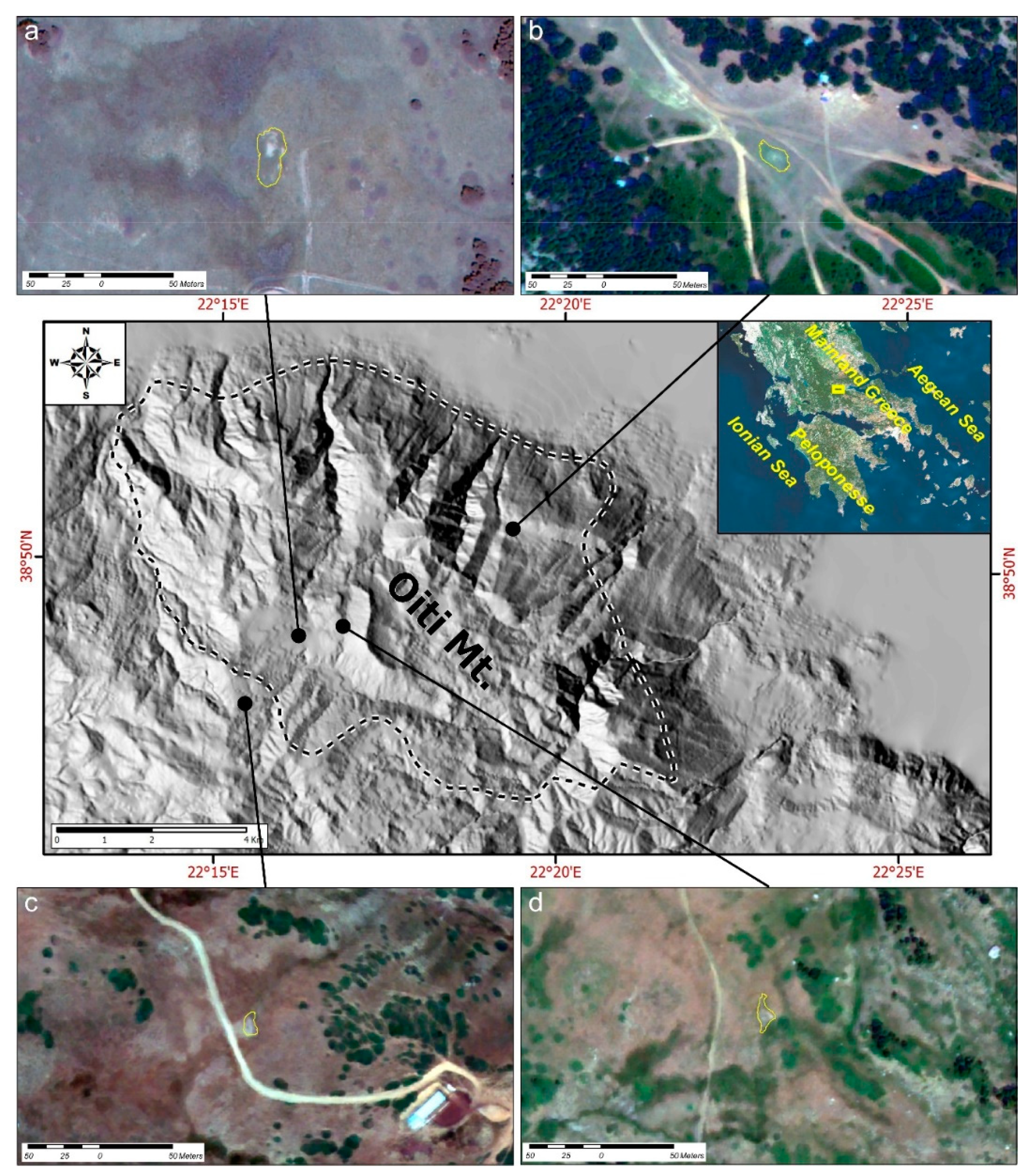
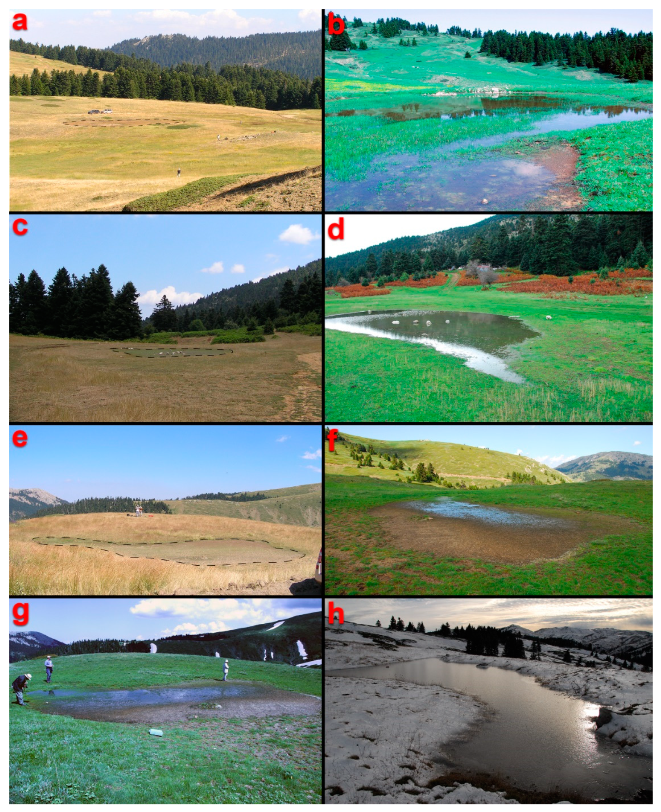
2.1. Study Area
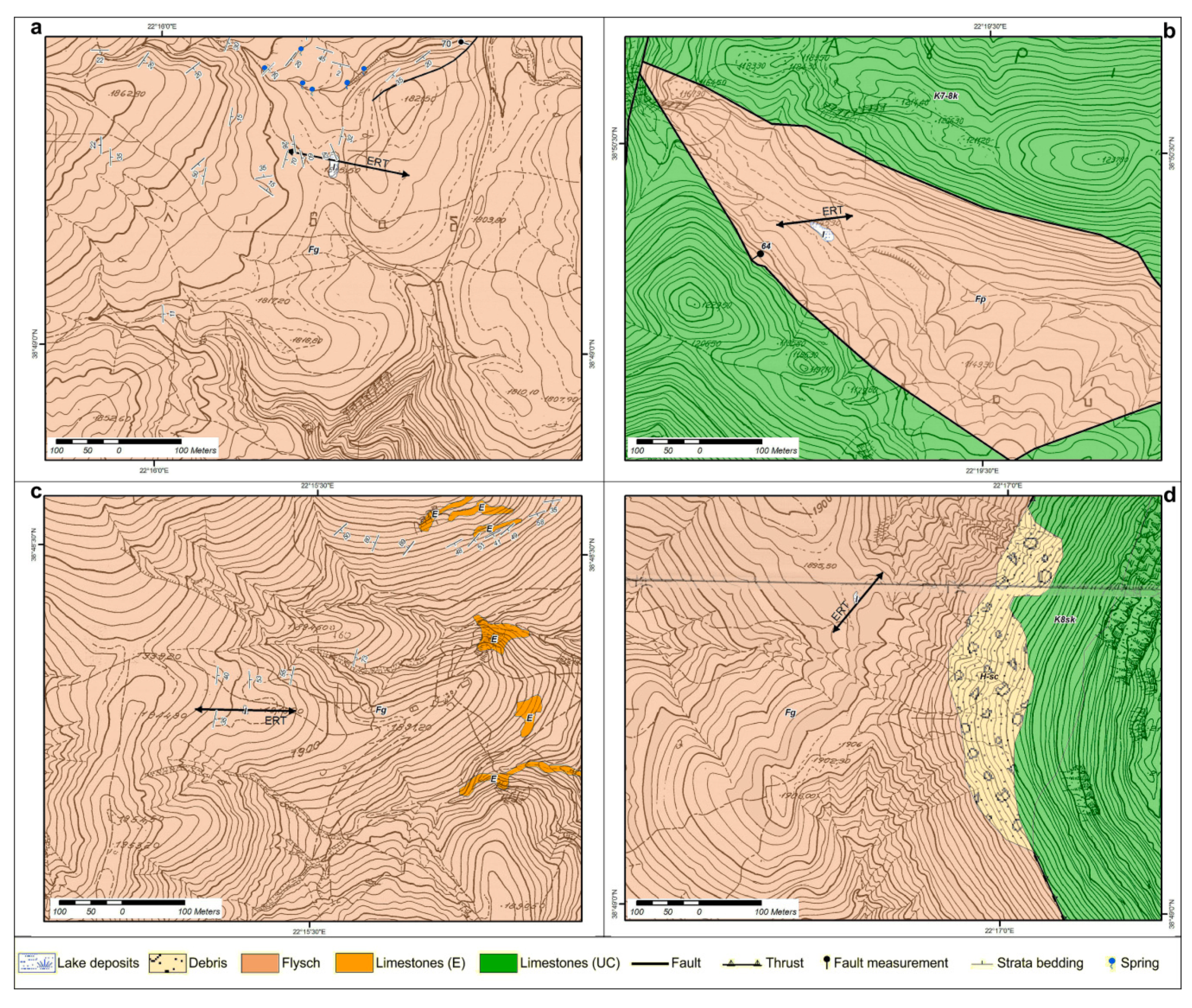
2.2. Geological and Geophysical Survey
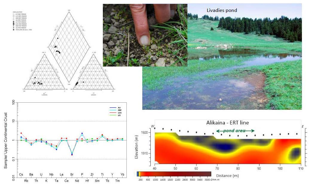
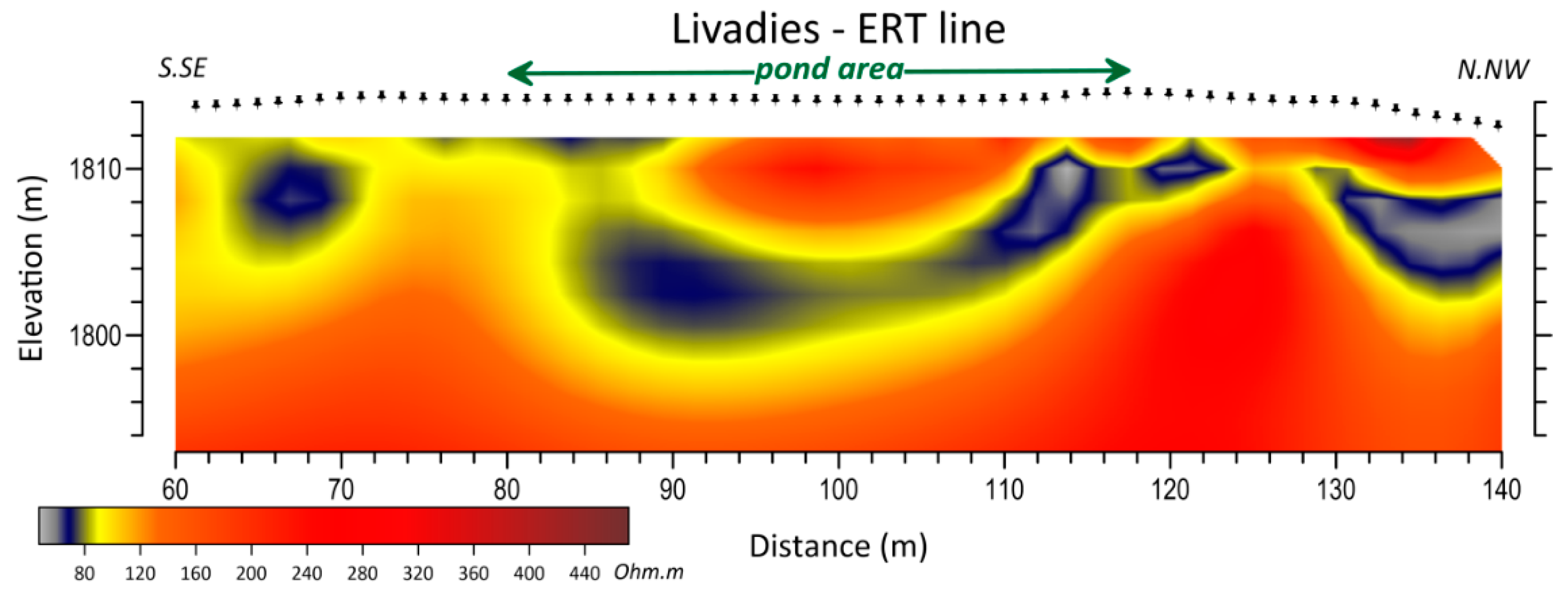
2.2.1. Pond of Livadies
2.2.2. Pond of Louka
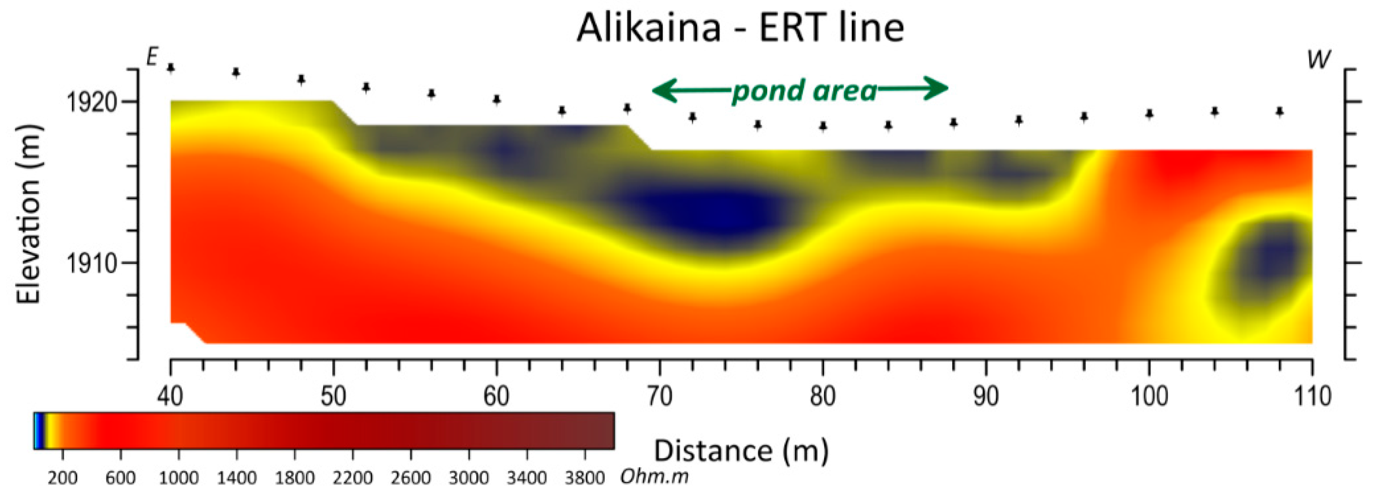
2.2.3. Pond of Alikaina
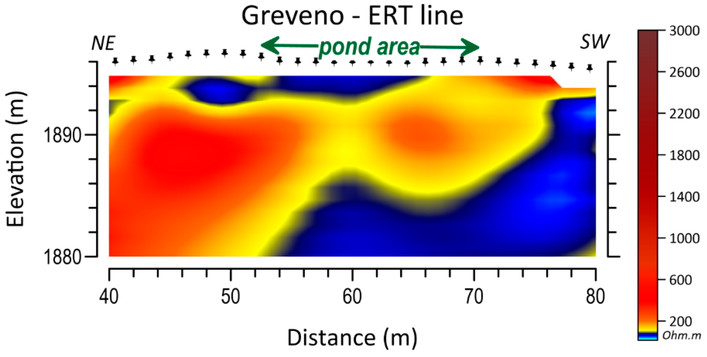
2.2.4. Pond of Greveno
2.3. Physical Characteristics
2.4. Sampling and Analytical Procedures
2.4.1. Bottom Sediments
2.4.2. Water
3. Results
3.1. Geological and Geophysical Survey
3.2. Physical Characteristics
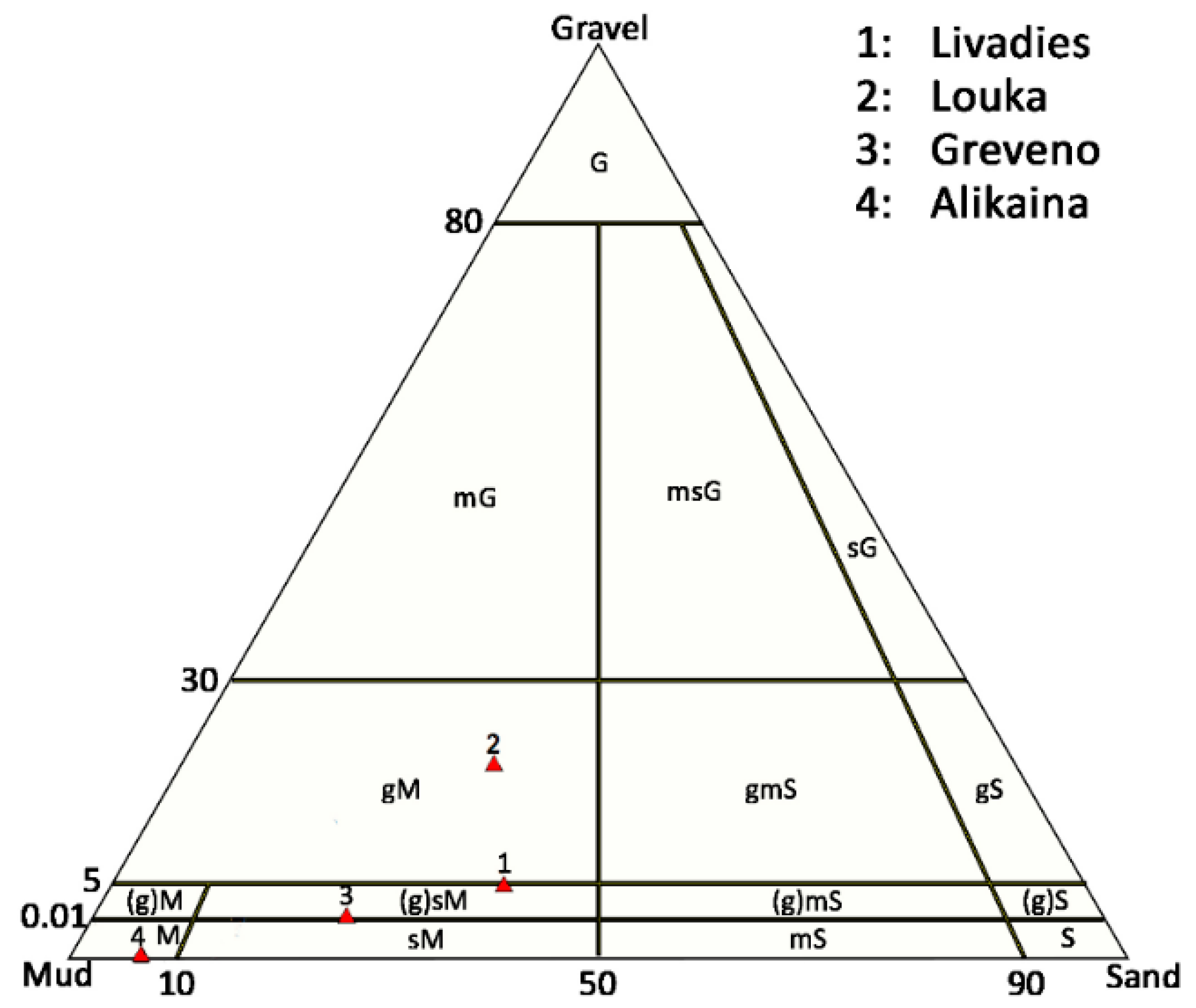
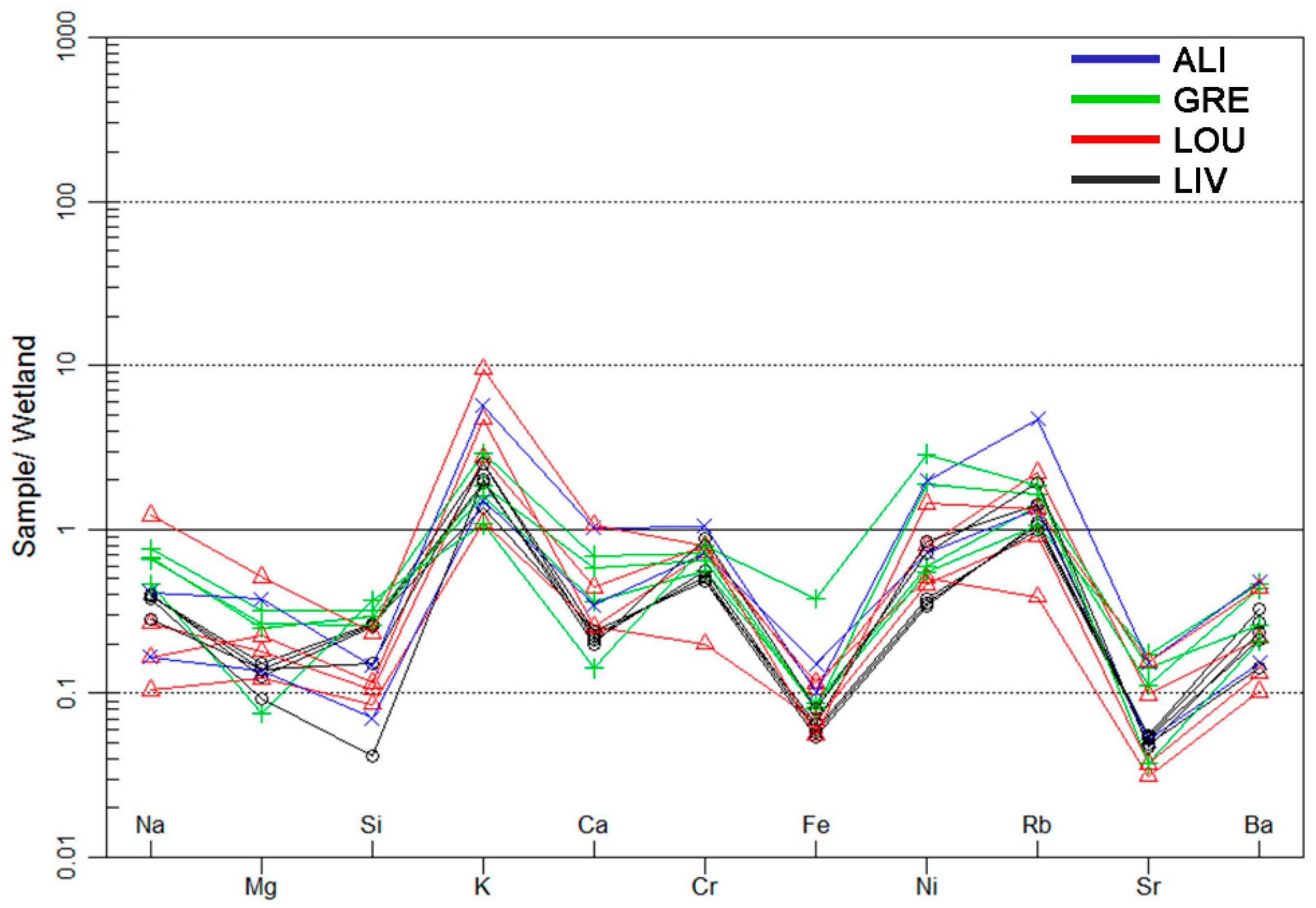
3.3. Bottom Sediments
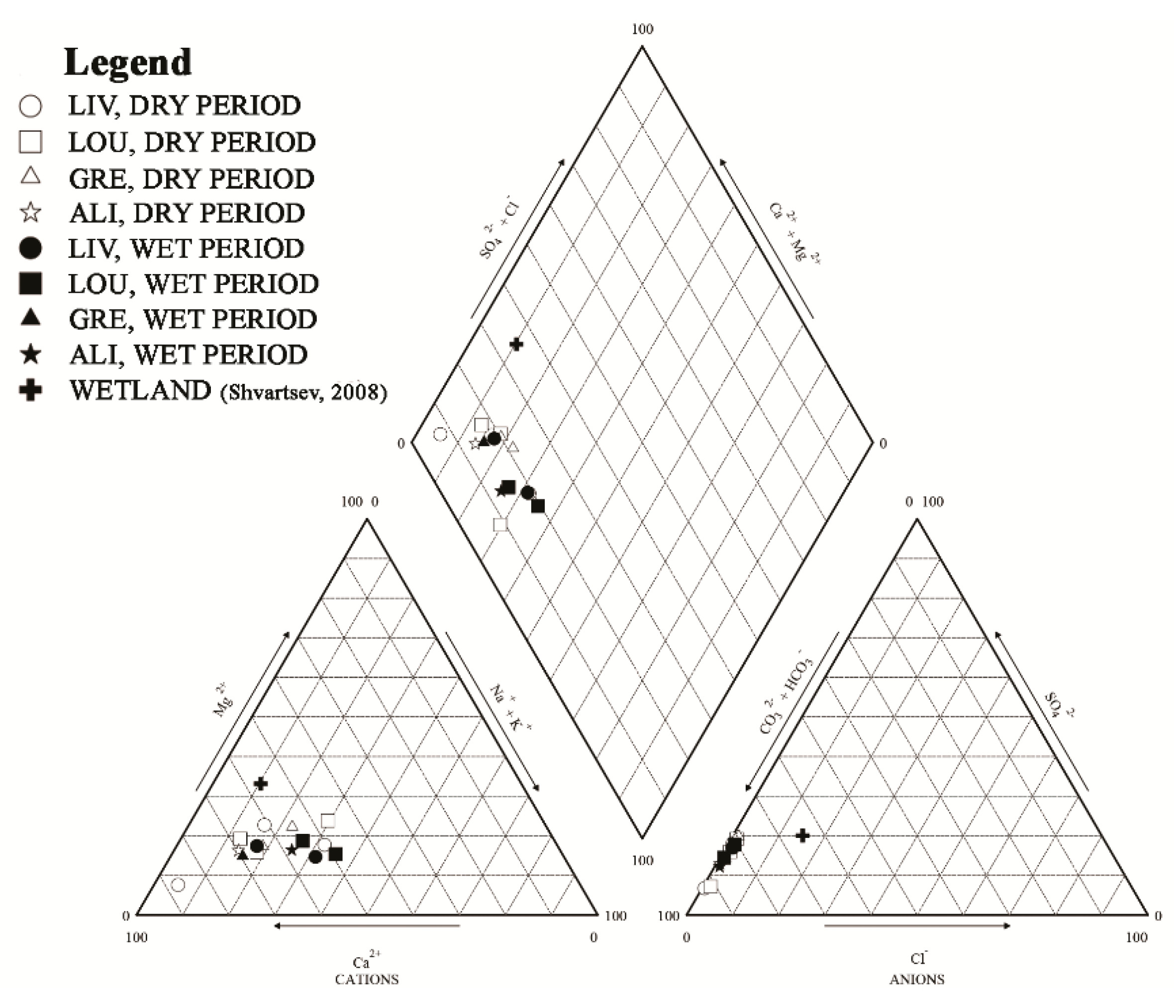
3.4. Water
4. Discussion
5. Conclusions
Supplementary Materials
Author Contributions
Funding
Acknowledgments
Conflicts of Interest
References
- Deil, U. A review on habitats, plant traits and vegetation of ephemeral wetlands—A global perspective. Phytocoenologia 2005, 35, 533–705. [Google Scholar] [CrossRef]
- Zacharias, I.; Dimitriou, E.; Dekker, A.; Dorsman, E. Overview of temporary ponds in the Mediterranean region: Threats, management and conservation issues. J. Environ. Biol. 2007, 28, 1–9. [Google Scholar] [PubMed]
- Grillas, P.; Roché, J. Vegetation of Temporary Marshes, Ecology and Management; Tour du Valat: Arles, France, 1997. [Google Scholar]
- Nicolet, P.; Biggs, J.; Fox, G.; Hodson, M.; Reynolds, C.; Whitfield, M.; Williams, P. The wetland plant and macroinvertebrate assemblages of temporary ponds in England and Wales. Biol. Conserv. 2004, 120, 261–278. [Google Scholar] [CrossRef]
- Williams, P.; Biggs, J.; Fox, G.; Nicolet, P.; Whitfield, M. History, origins and importance of temporary ponds. Freshw. Forum 2001, 17, 7–15. [Google Scholar]
- European Commission. Directive 2000/60/EC; EU Water Framework Directive; European Commission: Brussels, Belgium, 2000; p. 72. [Google Scholar]
- Van Den Broeck, M.; Waterkeyn, A.; Rhazi, L.; Grillas, P.; Brendonck, L. Assessing the ecological integrity of endorheic wetlands, with focus on Mediterranean temporary ponds. Ecol. Indic. 2015, 54, 1–11. [Google Scholar] [CrossRef]
- Céréghino, R.; Biggs, J.; Oertli, B.; Declerck, S. The ecology of European ponds: Defining the characteristics of a neglected freshwater habitat. In Pond Conservation in Europe. Developments in Hydrobiology 210; Oertli, B., Céréghino, R., Biggs, J., Declerck, S., Hull, A., Miracle, M.R., Eds.; Springer: Dordrecht, The Netherlands, 2007; pp. 1–6. [Google Scholar]
- Collinson, N.H.; Biggs, J.; Corfield, A.; Hodson, M.J.; Walker, D.; Whitfield, M.; Williams, P.J. Temporary and permanent ponds: An assessment of the effects of drying out on the conservation value of aquatic macroinvertebrate communities. Biol. Conserv. 1995, 74, 125–133. [Google Scholar] [CrossRef]
- Grillas, P.; Gauthier, P.; Yavercovski, N.; Perennou, C. Mediterranean Temporary Pools. Issues Relating to Conservation, Functioning and Management; Station Biologique de la Tour du Valat: Arles, France, 2004; Volume 1. [Google Scholar]
- Zacharias, I.; Zamparas, M. Mediterranean temporary ponds. A disappearing ecosystem. Biodivers. Conserv. 2010, 19, 3827–3834. [Google Scholar] [CrossRef]
- Pinto-Cruz, C.; Barbosa, A.M.; Molina, J.A.; Espírito-Santo, M.D. Biotic and abiotic parameters that distinguish types of temporary ponds in a Mediterranean ecosystem. Ecol. Indic. 2011, 11, 1658–1663. [Google Scholar] [CrossRef]
- Williams, D.D. The Biology of Temporary Waters; Oxford University Press: Oxford, UK, 2006. [Google Scholar]
- Angeler, D.G.; Moreno, J.M. Zooplankton community resilience after presstype anthropogenic stress in temporary ponds. Ecol. Appl. 2007, 17, 1105–1115. [Google Scholar] [CrossRef]
- Foteinis, S.; Mpizoura, K.; Panagopoulos, G.; Chatzisymeon, E.; Kallithrakas-Kontos, N.; Manutsoglu, E. A novel use of caesium-137 technique to estimate human interference and historical water level in a Mediterranean Temporary Pond. J. Environ. Radioact. 2014, 127, 75–81. [Google Scholar] [CrossRef]
- Bagella, S.; Gascón, S.; Caria, M.C.; Sala, J.; Mariani, M.A.; Boix, D. Identifying key environmental factors related to plant and crustacean assemblages in Mediterranean temporary ponds. Biodivers. Conserv. 2010, 19, 1749–1768. [Google Scholar] [CrossRef]
- Bauder, T.E. Inundation effects on small-scale plant distributions in San Diego, California vernal pools. Aquat. Ecol. 2000, 34, 43–61. [Google Scholar] [CrossRef]
- Šilc, U.; Kavgaci, A.; Čarni, A.; Başaran, M.; Košir, P.; Marinšek, A. Variability of vegetation of temporary pond along gradients of stagnant water and altitude in South-West Anatolia. Pak. J. Bot. 2011, 43, 2323–2330. [Google Scholar]
- Céréghino, R.; Boix, D. The ecological role of ponds in a changing world. Hydrobiologia 2014, 723, 1–6. [Google Scholar] [CrossRef]
- Ruiz, E. Management of Natura 2000 Habitats. 3170 Mediterranean Temporary Ponds; European Commission: Brussels, Belgium, 2008. [Google Scholar]
- Kanellopoulos, C.; Argyraki, A. Soil baseline geochemistry and plant response in areas of complex geology. Application to NW Euboea, Greece. Chem. Erde–Geochem. 2013, 73, 519–532. [Google Scholar] [CrossRef]
- Delipetrou, P.; Dimitriadis, I.; Zikos, A.; Sarika, M.; Georghiou, K. Base study and Interannual Variation of Temporary Pond (3170*) Communities in Mt. Oiti and Mt. Kallidromo. Part A: Flora and Vegetation. Deliverable A.3.1.a for the Project LIFE11 NAT/GR/2014–ForOpenForests; National and Kapodistrian University of Athens—HSPN: Athens, Greece, 2014. [Google Scholar]
- Marrone, F. Report on the Non-Malacostracancrustaceans (Crustacea: Branchiopoda, Copepoda, Ostracoda) from the Temporary Ponds Included in the “LIFE11 NAT/GR/1014 ForOpenForests” Project. Supplement to the Deliverable A.3.1.c for the Project LIFE11 NAT/GR/2014—ForOpenForests; National and Kapodistrian University of Athens—HSPN: Athens, Greece, 2018. [Google Scholar]
- European Commission. Guidance Document No 12: The Role of Wetlands in the Water Framework Directive. Common Implementation Strategy for the Water Framework Directive (2000/60/EC); European Commission: Brussels, Belgium, 2003. [Google Scholar]
- European Commission. Interpretation Manual of European Union Habitats Directive; Natura 2000, Nature and biodiversity, EUR; European Commission: Brussels, Belgium, 2003; pp. 32–33. [Google Scholar]
- European Commission. Guidance Document No 13: Overall Approach to the Classification of Ecological Status and Ecological Potential. Common Implementation Strategy for the Water Framework Directive (2000/60/EC); European Commission: Brussels, Belgium, 2005. [Google Scholar]
- Dimitriou, E.; Karaouzas, I.; Skoulikidis, N.; Zacharias, I. Assessing the environmental status of Mediterranean temporary ponds in Greece. Ann. Limnol.–Int. J. Lim. 2016, 42, 33–41. [Google Scholar] [CrossRef]
- Mertzanis, A.; Syleounis, S.; Mertzanis, K.; Skouras, A.; Efthimiou, G. Nature trails management and enhancement: The case of Hercules at the Oiti Mountain (Greece). J. Int. Sci. Publ. Ecol. Saf. 2015, 9, 1314–7234. [Google Scholar]
- Alexopoulos, J.D.; Dilalos, S.; Vassilakis, E.; Michelioudakis, D.; Mavroulis, S.; Farangitakis, P. A Geophysical Insight for the Occurrence of Mediterranean Temporary Ponds on Mts. Oiti and Kallidromo (Greece). In Proceedings of the Near Surface Geoscience 2014—20th European Meeting of Environmental and Engineering Geophysics, Athens, Greece, 14–18 September 2014. [Google Scholar]
- Jayawickreme, D.H.; Jobbágy, E.G.; Jackson, R.B. Geophysical subsurface imaging for ecological applications. New Phytol. 2014, 201, 1170–1175. [Google Scholar] [CrossRef]
- Papanikolaou, D. The three metamorphic belts of the Hellenides; a review and a kinematic interpretation, 17:551–561. In The Geological Evolution of the Eastern Mediterranean; Dixon, J.E., Robertson, A.H., Eds.; Geological Society of London: Oxford, UK, 1984. [Google Scholar]
- Marinos, G.; Anastopoulos, I.; Maratos, G.; Melidonis, N.; Andronopoulos, V.; Papastamatiou, I.; Tataris, A.; Vetoulis, D.; Bornovas, I.; Katsikatsos, G.; et al. The Geological Map of Greece, Lamia Sheet, Scale 1:50000; IGME: Athens, Greece, 1967. [Google Scholar]
- Karipi, S.; Tsikouras, B.; Hatzipanagiotou, K. Petrology and geochemistry of granitic pebbles in the Parnassos flysch at Iti Mountain, continental Central Greece. Bull. Geol. Soc. Greece 2007, 40, 816–828. [Google Scholar] [CrossRef][Green Version]
- Moser, D.; Zechmeister, H.; Plutzar, C.; Sauberer, N.; Wrbka, T.; Grabherr, G. Landscape patch shape complexity as an effective measure for plant species richness in rural landscapes. Landsc. Ecol. 2002, 17, 657–669. [Google Scholar] [CrossRef]
- Bagella, S.; Gascón, S.; Filigheddu, R.; Cogoni, A.; Boix, D. Mediterranean Temporary Ponds: New challengesfrom a neglected habitat. Hydrobiologia 2016, 782, 1–10. [Google Scholar] [CrossRef]
- Folk, R.L. Petrology of Sedimentary Rocks; Hemphill Publishing Co: Austin, TX, USA, 1974. [Google Scholar]
- Blott, S.J.; Pye, K. GRADISTAT: A grain size distribution and statistics package for the analysis of unconsolidated sediments. Earth Surf. Process. Landf. 2001, 26, 1237–1248. [Google Scholar] [CrossRef]
- Salerno, F.; Gambelli, S.; Viviano, G.; Thakuri, S.; Guyennon, N.D.; Agata, C.; Diolaiuti, G.; Smiraglia, C.; Stefani, F.; Bocchiola, D.; et al. High alpine ponds shift upwards as average temperatures increase: A case study of the Ortles–Cevedale mountain group (Southern Alps, Italy) over the last 50years. Glob. Planet. Chang. 2014, 120, 81–91. [Google Scholar] [CrossRef]
- McLatchey, G.P.; Reddy, K.R. Regulation of organic matter decomposition and nutrient release in a wetland soil. J. Environ. Qual. 1998, 27, 1268–1274. [Google Scholar] [CrossRef]
- Cho, D.; Jiang, S.; Kwon, S.H. Chemical and Biological Analyses of Bay Sediment Where Magnesium Oxide Compounds are Applied. Environ. Eng. Res. 2014, 19, 101–105. [Google Scholar] [CrossRef]
- Taylor, S.R.; McLennan, S.M. The geochemical evolution of the continental crust. Rev. Geophys. 1995, 33, 241–265. [Google Scholar] [CrossRef]
- Kissoon, L.T.T.; Jacob, D.L.; Hanson, M.A.; Herwig, B.R.; Bowe, S.E.; Otte, M.L. Multi-Elements in Waters and Sediments of Shallow Lakes: Relationships with Water, Sediment, and Watershed Characteristics. Wetlands 2015, 35, 443–457. [Google Scholar] [CrossRef]
- Vasilatos, C.; Megremi, I.; Economou-Eliopoulos, M.; Mitsis, I. Hexavalent chromium and other toxic elements in natural waters in the Thiva- Tanagra- Malakasa Basin, Greece. Hell. J. Geosci. 2008, 43, 57–66. [Google Scholar]
- Vasilatos, C.; Megremi, I.; Economou-Eliopoulos, M. Geochemical characteristics of natural waters contaminated by hexavalent chromium, in Eastern Sterea Hellas, Greece. Sci. Ann. 2010, 99, 347–353. [Google Scholar]
- Megremi, I.; Vasilatos, C.; Atsarou, A.; Theodoratou, C.; Economou–Eliopoulos, M.; Mitsis, I. Geochemical evidences for the sources of the Cr (VI) contamination in groundwater in central Euboea and Assopos-Thiva basins, Greece: Natural versus anthropogenic origin. Eur. Water 2013, 41, 23–34. [Google Scholar]
- Megremi, I.; Vasilatos, C.; Vassilakis, E.; Economou-Eliopoulos, M. Spatial diversity of Cr distribution in soil and groundwater sites in relation with land use management in a Mediterranean region: The case of C. Evia and Assopos-Thiva Basins. Sci. Total Environ. 2019, 651, 656–667. [Google Scholar] [CrossRef] [PubMed]
- Berner, E.K.; Berner, R.A. The Global Water Cycle Geochemistry and the Environment; Englewood Cliffs, N.J., Prentice-Hall: Upper Saddle River, NJ, USA, 1987; p. 397. [Google Scholar]
- Shvartsev, S.L. Geochemistry of Fresh Groundwater in the Main Landscape Zones of the Earth. Geochem. Int. 2008, 46, 1285–1398. [Google Scholar] [CrossRef]
- Piper, A.M. A Graphic Procedure in the Geochemical Interpretation of Water Analysis; USGS Groundwater Note: Reston, VA, USA, 1953; No. 1. [Google Scholar]
- Argyraki, A.; Godelitsas, A.; Petrakaki, N.; Astilleros, J.M.; Karageorgis, A. Mobilization of Pb from Weathered Shots at a Firing Range in Athens, Greece. In Proceedings of the Goldschmidt 2011 Conference Abstracts, Mineralogical Magazine, Prague, Czech Republic, 14–19 August 2011; p. 450. [Google Scholar]
- Delipetrou, P.; Dimitriadis, I.; Koutsovoulou, K.; Thanos, C.; Georghiou, K. Population Dynamics of Veronica Oetaea. Deliverable A.4.1. for the Project LIFE11 NAT/GR/2014–ForOpenForests; National and Kapodistrian University of Athens–HSPN: Athens, Greece, 2015. [Google Scholar]


| Pond Name | Abbreviation | Altitude (m a.s.l.) | Area (m2) |
|---|---|---|---|
| Livadies | LIV | 1815 | 607.9 |
| Louka | LOU | 1114 | 252.1 |
| Greveno | GRE | 1895 | 158.4 |
| Alikaina | ALI | 1919 | 112.5 |
| Livadies | Louka | Greveno | Alikaina | |
|---|---|---|---|---|
| Area (m2) | 607.9 | 252.1 | 158.4 | 112.5 |
| Perimeter (m) | 111.4 | 72.3 | 67.8 | 46.4 |
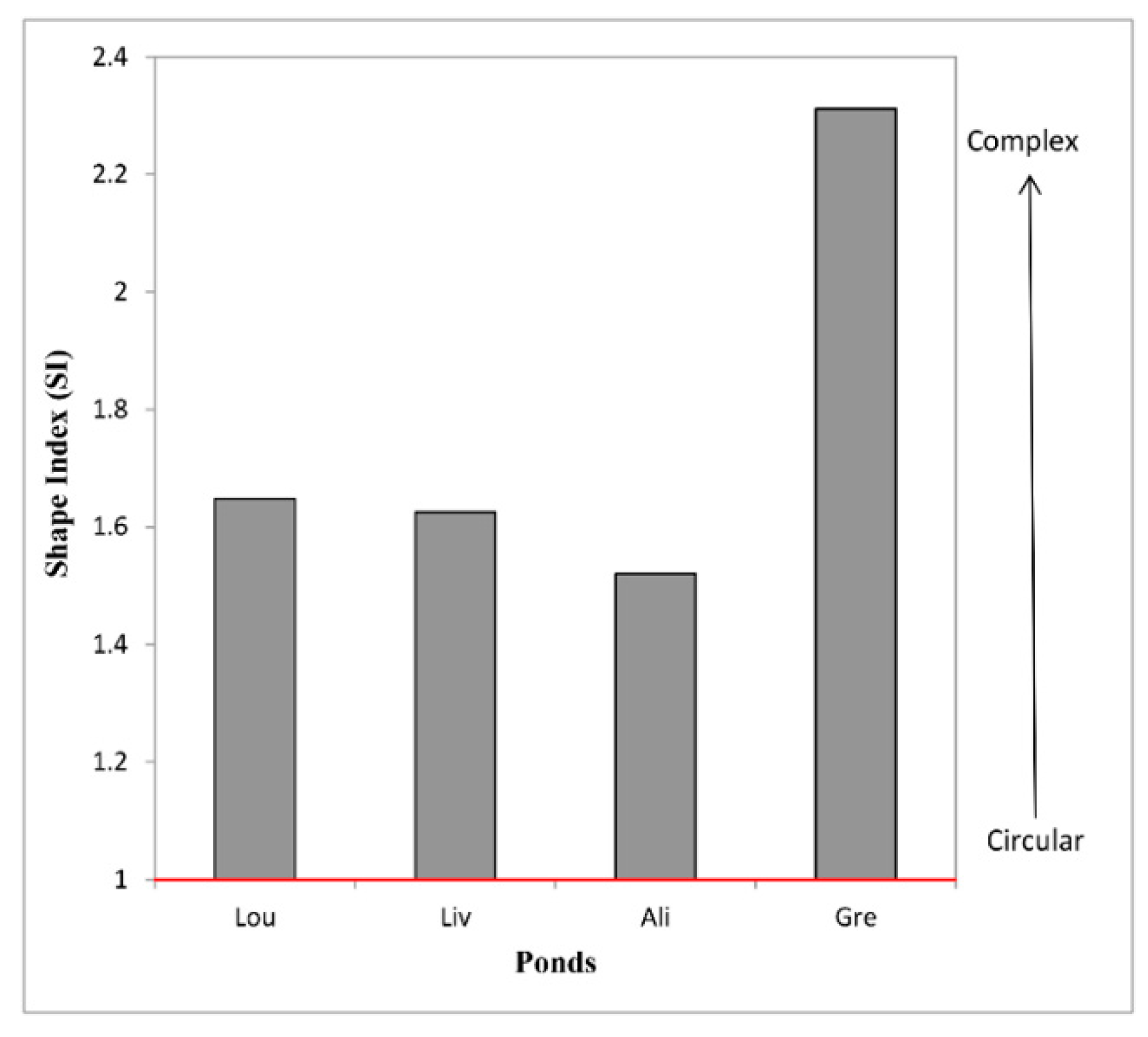
| Shape Index (SI) | 1.63 | 1.65 | 2.31 | 1.52 |
| Mean pond depth (cm) | 20.4 | 8 | 5.3 | 5 |
| Bottom sediments granulometry | Gravelly Mud | Sandy Mud | Sandy Mud | Mud |
| LIV | LOU | GRE | ALI | |
|---|---|---|---|---|
| Quartz | MJ | MJ | MJ | MJ |
| Alkali Feldpars | MD | TR/MD | MD | MD |
| Illite | TR | TR | TR/MD | MD |
| Smectite | TR/MD | TR/MD | TR | tr |
| Chlorite | TR | TR | TR | TR |
| Sepiolite | tr | tr | tr | |
| Hornblende | tr |
| Ponds | ||||||||||||||
|---|---|---|---|---|---|---|---|---|---|---|---|---|---|---|
| Variable | LIV | LOU | GRE | ALI | LOU | LIV | ALI | GRE | LOU | LIV | ALI | GRE | ||
| % | µg·g−1 | µg·g−1 | ||||||||||||
| SiO2 | 62.43 | 52.4 | 54.96 | 57.93 | As | 8 | 15 | 8 | 4 | Ni | 144 | 77 | 129 | 80 |
| Al2O3 | 14.65 | 17.98 | 14.92 | 15.21 | Ba | 383 | 318 | 315 | 333 | Pb | 69 | 20 | 24 | 24 |
| Fe2O3 | 7.1 | 7.5 | 6.11 | 7.39 | Bi | 0 | 0 | 0 | 0 | Pr | 8 | 6 | 6 | 6 |
| MgO | 2.38 | 2.35 | 2.3 | 2.83 | Ce | 80 | 61 | 62 | 62 | Rb | 140 | 100 | 120 | 113 |
| CaO | 0.42 | 0.54 | 0.57 | 0.42 | Co | 27 | 26 | 28 | 22 | Sc | 20 | 15 | 16 | 15 |
| Na2O | 1.5 | 0.59 | 1.37 | 1.42 | Cs | 9 | 4 | 6 | 5 | Sm | 5 | 4 | 5 | 5 |
| K2O | 2.18 | 2.45 | 2.36 | 2.8 | Cu | 39 | 35 | 42 | 32 | Sr | 58 | 72 | 63 | 74 |
| TiO2 | 0.86 | 0.98 | 0.8 | 0.81 | Dy | 5 | 4 | 4 | 4 | Ta | 1 | 1 | 1 | 1 |
| P2O5 | 0.15 | 0.19 | 0.3 | 0.38 | Er | 3 | 2 | 2 | 2 | Tb | 1 | 1 | 1 | 1 |
| MnO | 0.05 | 0.06 | 0.06 | 0.08 | Eu | 1 | 1 | 1 | 1 | Th | 12 | 9 | 10 | 10 |
| Cr2O3 | 0.024 | 0.036 | 0.021 | 0.036 | Ga | 22 | 18 | 18 | 18 | U | 3 | 3 | 2 | 3 |
| C | 1.22 | 2.4 | 4.67 | 2.2 | Gd | 5 | 4 | 4 | 4 | V | 164 | 131 | 141 | 125 |
| S | <0.02 | <0.02 | <0.02 | <0.02 | Hf | 5 | 6 | 5 | 5 | Y | 24 | 22 | 21 | 21 |
| OM | 3.24 | 5.99 | 9 | 4.78 | La | 39 | 27 | 29 | 29 | Yb | 3 | 3 | 2 | 2 |
| Nb | 15 | 13 | 12 | 12 | Zn | 99 | 92 | 114 | 105 | |||||
| Nd | 30 | 23 | 23 | 24 | Zr | 162 | 229 | 180 | 167 | |||||
| DRY PERIOD | WET PERIOD | |||||||||||||||
|---|---|---|---|---|---|---|---|---|---|---|---|---|---|---|---|---|
| 2012 | 2013 | 2014 | 2013 | 2014 | ||||||||||||
| Variable | Units | LIV | LOU | LIV | LOU | GRE | LIV | LOU | GRE | ALI | LOU | LIV | GRE | ALI | LIV | GRE |
| Τ | °C | 12.1 | 11.9 | 13.8 | 12.9 | 14.4 | 10.1 | 10.3 | 11.2 | 9.5 | 21.9 | 20.0 | 25.5 | 21.0 | 19.7 | 22.5 |
| pH | 7.0 | 7.1 | 6.5 | 6.4 | 6.1 | 7.6 | 7.5 | 7.4 | 8.2 | 7.1 | 7.1 | 7.1 | 7.0 | 5.8 | 6.1 | |
| Eh | mV | −11 | −16 | 17.3 | 22.8 | 39.6 | −37 | −20 | −39 | −46 | −16 | −16 | −16 | −11 | 63 | 47 |
| Conductivity | µS | 22.4 | 56.2 | 130 | 203 | 323 | 21.4 | 43 | 55.9 | 21.2 | 64.5 | 40.5 | 84.2 | 52.2 | 50.1 | 62 |
| TDS | mg·L−1 | 11.2 | 28.7 | 69 | 108 | 176 | 11 | 23.3 | 29.8 | 11.6 | 31.6 | 22.1 | 42.1 | 26.1 | 26.2 | 33.1 |
| TOC | mg·L−1 | 0.9 | bdl | 0.5 | 0.5 | 0.5 | 0.5 | 0.5 | 0.6 | 0.5 | bdl | bdl | bdl | bdl | 0.5 | 0.5 |
| NO3− | mg·L−1 | bdl | bdl | 17.26 | 32.76 | 36.30 | 7.08 | 5.31 | 5.31 | 5.75 | bdl | bdl | bdl | bdl | 5.75 | 2.66 |
| NO2 | mg·L−1 | bdl | bdl | bdl | bdl | bdl | bdl | bdl | bdl | bdl | bdl | bdl | bdl | bdl | bdl | bdl |
| ΝH3 | mg·L−1 | 2.67 | 0.12 | 2.55 | 1.34 | 0.24 | 0.10 | 0.12 | 0.10 | 0.06 | 0.12 | 1.09 | 0.12 | 0.12 | 0.64 | 0.77 |
| PO43− | mg·L−1 | 0.09 | 0.53 | 0.1 | 0.2 | 0.1 | 0.1 | 0.1 | 0.1 | 0.2 | 0.35 | 0.45 | 0.25 | 0.95 | 0.60 | 0.30 |
| Cl− | mg·L−1 | bdl | bdl | bdl | bdl | bdl | 0.5 | bdl | 0.5 | 0.5 | bdl | bdl | bdl | bdl | bdl | bdl |
| HCO3− | mg·L−1 | 135 | 46 | 45.9 | 51.7 | 49.7 | 59 | 43.3 | 59 | 48.9 | 70 | 46 | 56 | 69 | 44.7 | 43 |
| SO42− | mg·L−1 | 8 | <3 | 7.5 | 9.9 | 9.9 | 12.3 | 7.5 | 12.3 | 9.9 | 10 | 8 | 8 | 8 | 7.5 | 7.5 |
| Al | μg·L−1 | 9 | 79 | 38 | 120 | 82 | 78 | 128 | 77 | 139 | 36 | 71 | 68 | 45 | 116 | 193 |
| As | μg·L−1 | bdl | bdl | bdl | bdl | bdl | bdl | bdl | bdl | bdl | 1 | bdl | 1 | 1 | 1 | 0.6 |
| B | μg·L−1 | bdl | 10 | bdl | 6 | 6 | bdl | bdl | bdl | bdl | 6 | 9 | 28 | 28 | 14 | 9 |
| Ba | μg·L−1 | 23 | 4 | 9 | 6 | 12 | 6 | 3 | 13 | 5 | 4 | 7 | 13 | 12 | 7 | 6 |
| Br | μg·L−1 | bdl | bdl | bdl | bdl | 6 | bdl | 5 | 8 | bdl | 7 | 9 | 13 | 21 | 7 | bdl |
| Ca | mg·L−1 | 39.4 | 3.1 | 2.9 | 5.3 | 4.3 | 2.5 | 3.0 | 8.2 | 4.1 | 2.9 | 6.9 | 12.2 | 12.6 | 2.4 | 1.7 |
| Cd | µg·L−1 | bdl | bdl | bdl | bdl | bdl | bdl | bdl | bdl | bdl | 0.1 | 0.1 | 0.2 | 0.1 | bdl | 0.2 |
| Cl | mg·L−1 | 2.0 | 2.0 | 1.0 | 1.0 | 1.0 | 1.0 | bdl | 2.0 | 1.0 | 1.0 | 1.0 | 1.0 | 5.0 | bdl | bdl |
| Co | μg·L−1 | bdl | 0.03 | 0.04 | 0.22 | 0.06 | 0.06 | 0.07 | 0.04 | 0.16 | 0.09 | 0.15 | 0.41 | 0.22 | 0.07 | 0.21 |
| Cr | µg·L−1 | bdl | bdl | 1 | 1 | 1 | 1 | 1 | 1 | 1 | 1 | 1 | 1 | 1 | 1 | 1 |
| Cu | µg·L−1 | 1 | 3 | 3 | 2 | 4 | 3 | 2 | 3 | 2 | 5 | 7 | 7 | 7 | 4 | 4 |
| Fe | µg·L−1 | 13 | 59 | 47 | 92 | 75 | 52 | 100 | 70 | 131 | 56 | 69 | 88 | 48 | 69 | 325 |
| K | mg·L−1 | 0.4 | 3.2 | 0.9 | 1.9 | 1.1 | 1.7 | 0.8 | 2.0 | 1.0 | 1.7 | 1.3 | 3.9 | 6.5 | 1.4 | 0.7 |
| Mg | mg·L−1 | 2.1 | 1.0 | 0.7 | 0.8 | 1.1 | 0.5 | 0.5 | 1.4 | 0.6 | 0.6 | 1.1 | 1.6 | 2.2 | 0.4 | 0.3 |
| Mn | µg·L−1 | bdl | 1 | 1 | 9 | 2 | 1 | 2 | 1 | 4 | 5 | 4 | 39 | 10 | 1 | 2 |
| Mo | µg·L−1 | bdl | bdl | bdl | bdl | bdl | bdl | bdl | bdl | bdl | bdl | bdl | bdl | bdl | bdl | bdl |
| Na | mg·L−1 | 2.5 | 0.4 | 0.8 | 0.6 | 1.4 | 0.8 | 0.2 | 1.6 | 0.4 | 0.6 | 1.4 | 0.9 | 2.6 | 0.8 | 1.0 |
| Ni | µg·L−1 | bdl | 1 | 1 | 2 | 1 | 1 | 1 | 1 | 2 | 2 | 5 | 5 | 3 | 2 | 7 |
| P | µg·L−1 | 35 | 226 | 44 | 72 | 55 | 29 | 39 | 40 | 67 | 191 | 100 | 406 | 144 | 249 | 130 |
| Pb | µg·L−1 | bdl | 1 | bdl | bdl | 1 | bdl | 1 | 1 | bdl | 1 | 1 | 1 | bdl | bdl | 2 |
| Rb | µg·L−1 | bdl | bdl | bdl | 1 | 1 | bdl | bdl | bdl | bdl | 1 | 1 | 2 | bdl | 1 | 1 |
| S | mg·L−1 | 2.0 | <1 | 2.0 | 3.0 | 3.0 | 3.0 | 2.0 | 4.0 | 3.0 | 2.0 | 2.0 | 2.0 | 3.0 | 2.0 | 2.0 |
| Si | µg·L−1 | 2977 | 390 | 887 | 356 | 998 | 866 | 290 | 1074 | 237 | 515 | 876 | 496 | 783 | 139 | 1232 |
| Sn | µg·L−1 | bdl | bdl | 0.06 | bdl | bdl | bdl | bdl | bdl | bdl | 0.07 | 0.11 | 0.06 | bdl | bdl | Bdl |
| Sr | µg·L−1 | 48 | 5 | 8 | 14 | 16 | 8 | 5 | 25 | 8 | 7 | 21 | 22 | 23 | 7 | 5 |
| V | µg·L−1 | bdl | bdl | bdl | 1 | bdl | bdl | bdl | bdl | 1 | bdl | 1 | 2 | 1 | 2 | 1 |
| Y | µg·L−1 | bdl | bdl | bdl | bdl | bdl | bdl | bdl | bdl | bdl | bdl | bdl | bdl | bdl | bdl | bdl |
| Zn | µg·L−1 | 4 | 8 | 4 | 6 | 9 | 4 | 6 | 8 | 4 | 12 | 15 | 9 | 17 | 7 | 5 |
| NATURACODE | WASTE DISPOSAL * | TOURISM | AGRICULTURE | HYDROLOGIC DISTURBANCE | OVERGRAZING | EXCAVATION | NO THREAT | ECOLOGICAL STATUS |
|---|---|---|---|---|---|---|---|---|
| GR1430004 | √ | excellent | ||||||
| GR2440002 | √ | √ | √ | at-risk | ||||
| GR4110001 | √ | good | ||||||
| GR4110002 | √ | at-risk | ||||||
| GR4110003 | √ | at-risk | ||||||
| GR4110004 | √ | √ | at-risk | |||||
| GR4210004 | √ | medium | ||||||
| GR4210007 | √ | medium | ||||||
| GR4210008 | √ | √ | medium | |||||
| GR4220005 | √ | at-risk | ||||||
| GR4220006 | √ | √ | good | |||||
| GR4220007 | √ | √ | good | |||||
| GR4220010 | √ | at-risk | ||||||
| GR4220014 | √ | √ | √ | at-risk | ||||
| GR4340001 | √ | √ | medium | |||||
| GR4340002 | √ | √ | √ | medium | ||||
| GR4340010 | √ | √ | medium | |||||
| GR4340013 | √ | √ | excellent | |||||
| GR2440007 | √ | √ | good | |||||
| Livadies | √ | excellent | ||||||
| Louka | √ | √ | √ | medium | ||||
| Greveno | √ | excellent | ||||||
| Alikaina | √ | excellent |
© 2019 by the authors. Licensee MDPI, Basel, Switzerland. This article is an open access article distributed under the terms and conditions of the Creative Commons Attribution (CC BY) license (http://creativecommons.org/licenses/by/4.0/).
Share and Cite
Vasilatos, C.; Anastasatou, M.; Alexopoulos, J.; Vassilakis, E.; Dilalos, S.; Antonopoulou, S.; Petrakis, S.; Delipetrou, P.; Georghiou, K.; Stamatakis, M. Assessment of the Geo-Environmental Status of European Union Priority Habitat Type “Mediterranean Temporary Ponds” in Mt. Oiti, Greece. Water 2019, 11, 1627. https://doi.org/10.3390/w11081627
Vasilatos C, Anastasatou M, Alexopoulos J, Vassilakis E, Dilalos S, Antonopoulou S, Petrakis S, Delipetrou P, Georghiou K, Stamatakis M. Assessment of the Geo-Environmental Status of European Union Priority Habitat Type “Mediterranean Temporary Ponds” in Mt. Oiti, Greece. Water. 2019; 11(8):1627. https://doi.org/10.3390/w11081627
Chicago/Turabian StyleVasilatos, Charalampos, Marianthi Anastasatou, John Alexopoulos, Emmanuel Vassilakis, Spyridon Dilalos, Sofia Antonopoulou, Stelios Petrakis, Pinelopi Delipetrou, Kyriacos Georghiou, and Michael Stamatakis. 2019. "Assessment of the Geo-Environmental Status of European Union Priority Habitat Type “Mediterranean Temporary Ponds” in Mt. Oiti, Greece" Water 11, no. 8: 1627. https://doi.org/10.3390/w11081627
APA StyleVasilatos, C., Anastasatou, M., Alexopoulos, J., Vassilakis, E., Dilalos, S., Antonopoulou, S., Petrakis, S., Delipetrou, P., Georghiou, K., & Stamatakis, M. (2019). Assessment of the Geo-Environmental Status of European Union Priority Habitat Type “Mediterranean Temporary Ponds” in Mt. Oiti, Greece. Water, 11(8), 1627. https://doi.org/10.3390/w11081627