Article

A New Framework for the Management and Radiological Protection of Groundwater Resources: The Implementation of a Portuguese Action Plan for Radon in Drinking Water and Impacts on Human Health

1
Department of Geology, Centre for Research and Technology of Agro-Environment and Biological Science, University of Trás-os-Montes e Alto Douro, 5001-801 Vila Real, Portugal
2
Department of Earth Sciences, Centre for Earth and Space Research of the University of Coimbra, Rua Sílvio Lima, Polo II University of Coimbra, 3004-531 Coimbra, Portugal
3
Department of Geology, Geosciences Centre of the University of Coimbra, University of Trás-os-Montes e Alto Douro, 5001-801 Vila Real, Portugal
4
Department of Civil Engineering, Centre for Research and Technology of Agro-Environment and Biological Science, University of Trás-os-Montes and Alto Douro, 5001-801 Vila Real, Portugal
5
Department of Geology, Chemistry Research Centre, University of Trás-os-Montes e Alto Douro, 5001-801 Vila Real, Portugal
*
Author to whom correspondence should be addressed.
Water 2019, 11(4), 760; https://doi.org/10.3390/w11040760
Submission received: 7 March 2019 / Revised: 30 March 2019 / Accepted: 10 April 2019 / Published: 12 April 2019
(This article belongs to the Special Issue Radioactive Isotopes in Hydrosphere)

Abstract

:
In general, this study was developed to assess the radon contamination in groundwater intended for human consumption, to raise awareness among policy-makers to implement a legal framework for drinking water management and the radiological protection of groundwater resources. Thus, we analyzed with parallel coordinate visualization (PCV) plots what features may influence the water–rock interaction and promote high-radon concentrations in water intended for human consumption. The results show that in granitic areas composed by biotite granites (Group V), although there is a higher radon production in the rocks, the radon transfer to groundwater was not effective, mainly due to the physical and chemical properties of the water. The main conclusions show that in all springs sampled (n = 69) for the entire study area, there are only four springs that must have an immediate intervention, and 22 of them are above the limit imposed by the Portuguese legislation. These results are intended to promote a Portuguese Action Plan for Radon that can be framed in the guidelines on the management and protection of groundwater resources.

1. Introduction

To ensure the sustainable use and protection of groundwater resources and aquifers in the frame of climate change, the drinking water contamination risks related to geogenic sources should be properly assessed. The groundwater pollution from geogenic sources should be duly studied and appreciated by policy-makers for the development of effective water management, through monitoring tools to evaluate the qualitative aquifer status and trends. Particular attention should be dedicated to the understanding of groundwater quality in its association with natural processes and anthropogenic inputs, as well as to aquifer vulnerability [1,2,3], in parallel with the strong need to improve advanced monitoring and early warning systems associated with the transport of pollutants from rocks, soils, and the vadose zone to groundwater. This research will also provide a real-time assessment of radon contamination in water supply and advanced monitoring that will give the evaluation of radiological impacts and trends in the integrated planning of land-uses and the management of groundwater quality. Innovative tools and solutions for decision support on groundwater remediation strategies will be produced, considering the regional water governance constraints. The fundamental principles of the National Water Plan (NWP) related to water planning aim at making the sustainable use of these natural resources in an integrated way through their protection and valorization, as well as the protection of people against extreme phenomena associated with water ingestion (e.g., radiological contamination).
Until 2020, Portugal has a National Strategy for Adaptation to Climate Change (NSACC), where it highlights some specific risks related to the reduction of the flow and recharge of aquifers, especially where these are scarcer. These risks from climate change also modify the water quality, mainly due to the reduction of dilution flow rates causing a deterioration of water bodies [4]. Following this NSACC report, several strategic objectives were defined from 2021 to 2027: (a) Promote sustainable use based on long-term protection of available water resources, (b) ensure the gradual reduction of groundwater pollution to prevent further contamination, and (c) ensure appropriate supply of good quality groundwater. Thus, these legal impositions also provide some measures to promote efficient management and governance of water, among which a reinforcement and operationalization of a new monitoring system that evaluates the water bodies is implied. Concerns about the overexploitation of water resources are also highlighted in the first inter-municipal planning of the wine-growing Douro region (IPADVT, in Portuguese), and more attention for some regions subject to the disorderly exploitation of water resources for public supply purposes is also reported [5]. The National Water Resources Information System (SNIRH) provides for the Portuguese territory a total of 22,641 groundwater monitoring points, of which only 779 of them have general information about the quality network of the water bodies related to contamination essentially by nitrates, chlorides, fluorides, and ammoniacal nitrogen [6]. The economic dimensions of sustainable management of groundwater resources are mainly focused on water pricing and water access for irrigation. Currently, there is not a willingness of policy-makers to ensure financial conditions for the implementation of a Portuguese Action Plan for Radon (PAPR) and active mitigation of water bodies contaminated by geogenic sources. Nevertheless, it is worth noting that the scarcity of water from climate changes could worsen the quality of water resources due to the adverse collateral effects of reduced aquifer recharge and consequently lower dilution of geogenic contaminants.
Radon (222Rn) is a noble radioactive gas resulting from geogenic sources, with high mobility in natural systems due to its short half-life (3.8 days). Exposure to this colorless, odorless, and tasteless substance can be a serious public health problem, since it is responsible for the radiation dose received by the human population [7,8,9,10,11]. According to the World Health Organization (WHO; [12]), radon is a carcinogenic agent reported as the second leading risk factor of lung cancer after tobacco, which is in accordance to recent epidemiological studies about radon exposure that causes about 20,000 deaths per year [13]. Regarding exposure to radon, a review of lung cancer mortality in northern Portugal developed by Veloso et al. [14] related 8514 lung cancer deaths with radon exposure. The primary source of radon in groundwater comes from the successive decays in uranium-bearing minerals of rocks and soils. In the subsoil, when the U-bearing mineral is subject to weathering, radon can easily migrate from the host mineral and precipitate into fractures and microfractures, onto the surfaces of the crystals, or even be mobilized through groundwater circulation under certain pH conditions [15,16,17,18,19,20,21,22,23]. The rate of weathering and hence of radon migration is conditioned by the rock hydraulic diffusivity [24,25,26,27,28,29,30]. The disintegration of 226Ra atoms provides the radon product which, being a gas, can easily migrate from the generation site to the intergranular rock spaces (emanation coefficient). In these circumstances and depending on the high amount of water in the rock pores attached to the minerals, radon diffusion can be increased [31].
Currently, some scientific limitations are also recognized by the scientific community in the knowledge of the control processes of radon production in rocks, as well as the mechanisms of transport that influence the water–rock interaction dynamics. The innovative goal of this study consists essentially in the evaluation of the ability of radon transfer from the geological substrate to groundwater. The porosity and the potential of radon production in rocks, and the physical and chemical conditions of drinkable water are considered the main contributing features to the radon contamination in water intended for human consumption. The main purpose of this study is to develop a PAPR in groundwater used for public consumption so that in the future, it can be applied by policy-makers in land-use planning and hydrographic region management plans. It is also intended to assess the risk of radon exposure, which includes the annual effective dose from ingestion and inhalation.

2. Materials and Methods
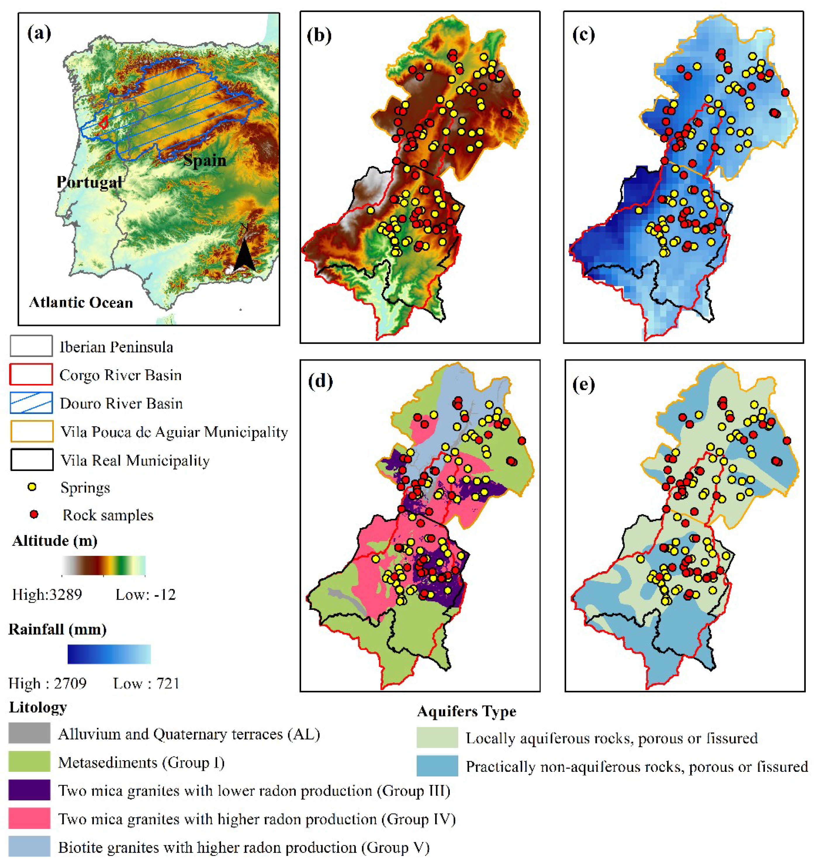
2.1. Study Area

The Douro River Basin is considered the third largest among the rivers of the Iberian Peninsula. It is an international river basin with a total area in the national territory of 19,218 km2, representing 13% of the entire area (Figure 1a). The spring of the Douro river is located in the Urbion mountain (Spain), at about 1700 m altitude, while the main water course extends along 927 km. The groundwater availability for this hydrographic region is around 1.084 hm−3 y−1, representing three groundwater bodies that produce water for human consumption [32].
The hydrographic basin of the Corgo River is located near Vila Real (VR) and Vila Pouca de Aguiar (VPA) municipalities (northern Portugal), and the length of its route is 43 km in an area of approximately 468 km2. The Corgo River is a tributary of the Douro River and runs mostly along the main regional geotectonic structure so-called the Penacova-Régua-Verín fault (PRVF) with a NNE–SSW direction, producing tectonic hillslopes ranging from 300 to 1400 m (Figure 1c). This study area is characterized by a cold-wet period from October to May, succeeded by a warm-dry period from July to August [35]. This study area also has from 1960 to 1991 an annual precipitation rate between 721 to 2709 mm (Figure 1d). The geology is characterized by Paleozoic metasediments (Group I) and granitoids with different radiological profiles, being classified by their installation age and their rock’s ability to produce radon (Figure 1e). Several groups of granitoids occur in this study area, namely two-mica granites with low-radon production (Group III), two-mica granites with high-radon production (Group IV), and biotite granites with high-radon production (Group V; [36]). As for water resources, its availability is very much conditioned by the geology of the territory, where the locally fractured aquiferous rocks stand out, consisting mainly of eruptive rocks (granites) and practically non-aquiferous rocks (metamorphic rocks), whose hydraulic productivity is low (Figure 1f).

2.2. Radiological Analysis in Water Intended for Water Consumption

This radiological study was carried out in two municipalities of the Corgo river basin (Vila Pouca de Aguiar and Vila Real) during the summer period (July 2014) in 69 sampled springs used for water supply. For radon analysis, the prior preparation for water sampling was developed in water vessels that contain 12 mL of scintillation cocktail (Betaplate). In these springs, some physical and chemical parameters (electrical conductivity, pH, and temperature) were measured in the field using portable equipments WTW LF320 and WTW pH320 (WTW, Trifthof, Upper Bavaria, Germany). The radiological analysis was performed in the Laboratory of Natural Radioactivity (LRN) in the University of Coimbra, using Perkin-Elmer® Quantullus 1220 ultra-sensitive spectrometer (Perkin-Elmer, Waltham, MA, USA) with Liquid Scintillation Counting (LSC). This analytical procedure comprises the collection of 10 mL of water samples into a Teflon-coated polyethylene vial [37], minimizing the turbulence to avoid the formation of air bubbles. After sealing the vial, the water with radon content should be shaken to mix the collected water with the Perkin-Elmer® scintillation cocktail. This necessary procedure implies that the radon is preferably concentrated in the organic phase, remaining confined immediately below the cocktail level (double-phase method; [38]).
After three hours of sample resting, where the equilibrium between the radon and its short half-life progeny is restored, the water samples are introduced into the spectrometer (Perkin-Elmer, Waltham, MA, USA) with corrective action on the measured activities as a function of the elapsed time between measurements and water collection. This latent time efficiency was assessed by measuring several standard solutions of 226Ra after radon had reached the secular equilibrium of 21 days. In general, the estimated overall error is less than 15% of the measured values [39].

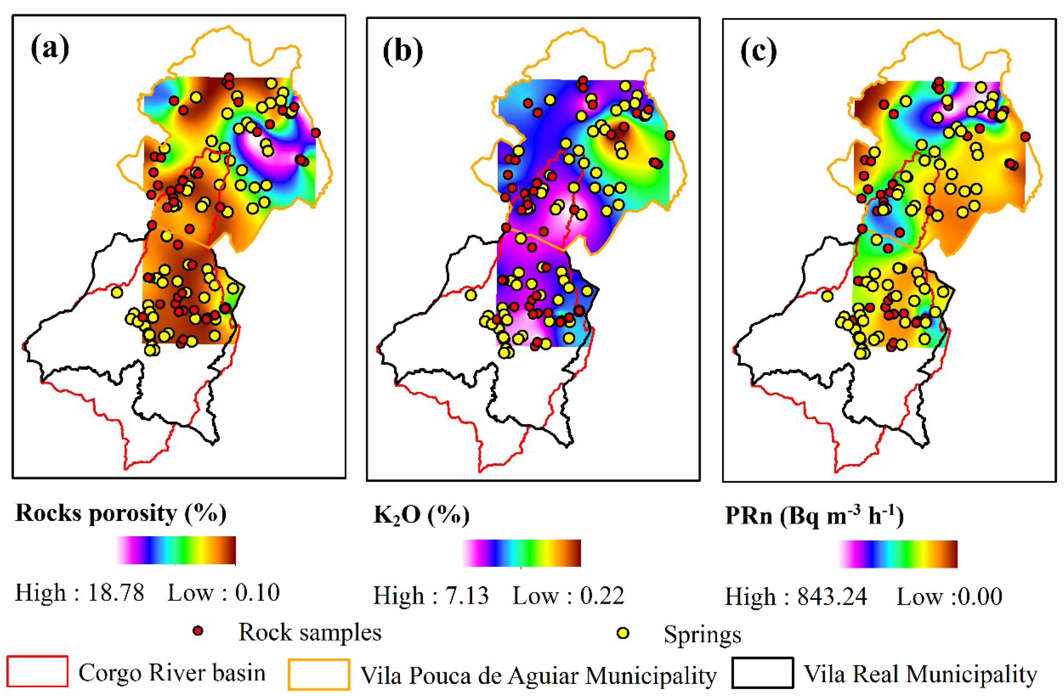
2.3. Determination of K2O on Rocks

To determine the K2O content in the rocks, a gamma spectrometer (ORTEC, Oak Ridge, TN, USA) with a NaI detector and 3 "diameter was used. The samples are placed inside a lead shield to protect against background radiation. A total of 56 representative rock samples were collected in the outcrops of metasedimentary (n = 11) and granitic units (n = 45), considering the cartographic representation of these lithologies. Ground rock samples of about 500 g with a particle size less than 2 mm were placed in beakers of Marinelli type with a volume of 0.2 L. These samples remain at rest with the minimum possible air inside the beaker, and the preparation date, its total weight (sample + beaker), and the analysis date were recorded. After this previous preparation, approximately 27 days were allowed to establish the isotopic balance between these radioisotopes and their progenies. The measurement time used was 36,000 s, which corresponds to about 10 h of continuous measurements. To develop an adequate calibration, standard measurements provided by the International Atomic Energy Agency (IAEA) were carried out under the same experimental conditions. Depending on the radioisotope analyzed and its activity, the uncertainties were variable, estimating between 5% and 25% of the measured value.

2.4. Determination of Porosity on Rocks

For the analysis of porosity in rocks, small rock fragments of the representative lithologies (n = 56) of the region under study were cut. Furthermore, for the determination of the apparent porosity, a Portuguese standard procedure [40] was used, being the entitled test method for natural stone: Determination of total and open porosity. Following this procedure, the samples were dried to a constant mass at 70 ± 5 °C. The constant mass was reached when the difference between two successive weighings within an approximate 24 h period was not more than 0.1% of the sample mass. Each sample was weighed (md) and placed in a vacuum vessel until the pressure was gradually lowered to 2.0 ± 0.7 kPa. This pressure was maintained for 2 h in order to eliminate the air contained in the open pores of the samples. Distilled water was slowly introduced at a temperature of 20 ± 5 °C so that the filling flow promoted full immersion of the samples after 15 min. When all samples were immersed, they were maintained at this pressure for a further 24 h and at the end, the immersed samples (mh) were weighed and rapidly wiped with a damp cloth, becoming the mass of the saturated sample with water (ms). The porosity was obtained by the ratio of the open pores volume to the apparent volume of the sample, following the equation:
P   =   ( ms md ) ( ms mh )   × 100
where P is the porosity (%), ms is the saturated sample weight (g), md is the dry sample weight (g), and mh is the immersed sample weight (g).

2.5. Assessment of Total Effective Dose from Radon Exposure in Drinking Water

The total annual effective dose for radon ingestion and inhalation were calculated according to the UNSCEAR report [41], as below:
Eing (mSv y1) = 222Rn (Bq L−1) × Wec × 10−3 m−3 L−1 × DCFing × 10−3
and
Einh (mSv y−1) = 222Rn (Bq L−1) × Raw × F × O × DCFinh × 10−3
where Eing is the annual effective dose from water ingestion (mSv y−1), Wec is the weighted estimate of consumption (60 L y−1), DCFing is the ingestion dose conversion factor (3.5 nSv Bq−1), Einh is the annual effective dose from inhalation (mSv y−1), Raw is the air–water concentration ratio (10−4), O is the indoor occupancy (7000 h y−1), F is the equilibrium factor between radon and its decay products (0.4), and DCFinh is the inhalation dose conversion factor (9 nSv (Bq h−1 m−3)−1).

2.6. Technical Workflow

The technical workflow was prepared to develop a Portuguese Action Plan for Radon (PAPR) in aquifer systems. This workflow is composed of several interconnected modules (Figure 2): (1) The central module that represents water planning policies transposed through the National Water Plan (NWP) of territorial scope, the Hydrographic Region Management Plans (HRMPs) that cover the hydrographic basins integrated in a hydrographic region, and the Specific Water Management Plans (SWMPs), which are complementary to the HRMPs, covering a specific sub-basin or geographic area [32]; (2) the external module that describes all features that contribute to the radon contamination, namely a geogenic source that promotes the radon production in rocks, a climatic feature (rainfall) to understand the dilution effect, and the physical and chemical properties (aquifer type, and physical and chemical properties of water) which may contribute to the effectiveness of water–rock interaction; (3) the module of corrective and awareness measures for the radiological protection of human health; and (4) the PAPR that covers all previous interconnected modules.
The NWP elaborates the principles of the planning of water resources by integrating the sustainable use of these natural resources with the protection and valorization of water bodies, as well as the protection of people against extreme phenomena associated with water contamination [4]. Furthermore, in the NWP, there is no reference related to the contamination by geogenic sources as the leading cause of negative impacts on the state of groundwater bodies. The Water Law (WL) has transposed into the Portuguese legal order by Directive 2000/60/EC, establishing a European framework for action in the field of water policy, the Water Framework Directive (WFD), where the environmental objectives should be followed through the application of specified measures in the HRMPs. These HRMPs for the Douro River basin are planning tools for water resources and aim at the management, protection, and environmental, social, and economic evaluation of water of the Douro river basin [32]. These plans aim to base and guide the protection and management of water, setting the standards of environmental quality and the criteria related to the water state. Although, the main purpose of the PAPR module is verifying if the radon contamination can be connected to several features which may contribute to the interaction of this problematic geogenic pollutant in the water supply. This new approach can also contribute to the demystification of the extreme contamination of groundwater bodies mentioned in these water resource planning, which aim at the management, protection, and environmental, social, and economic assessment of water at the level of integrated river basins (Corgo river basins) within the Douro river basin.

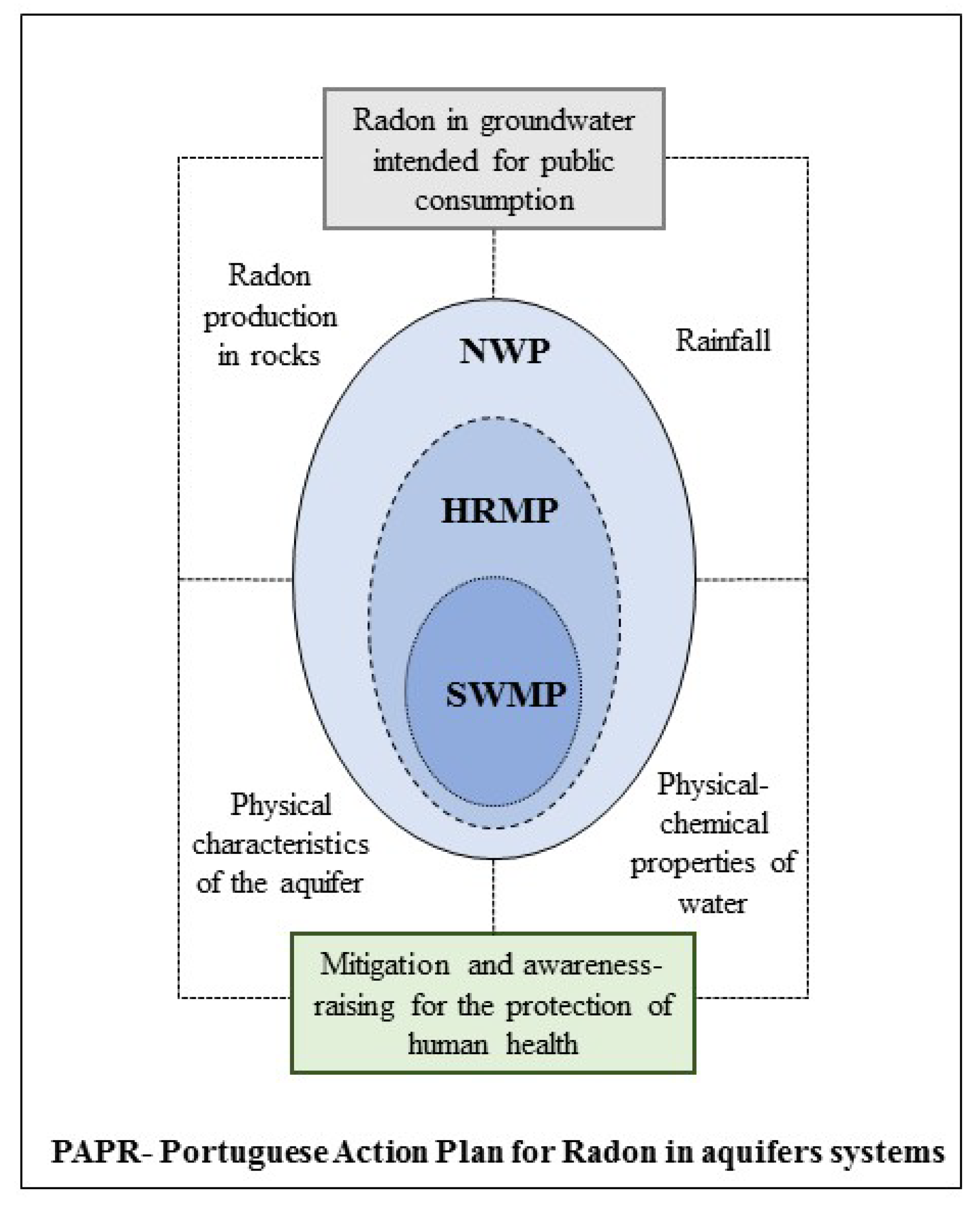
2.7. Management Guidelines

The European Directive [42] provides the health protection of the general public about radioactive substances exposure in water intended for human consumption. The member states shall set a parametric value of 100 Bq L−1, applicable for the monitoring of radon in the water supply. In the event of non-compliance with the parametric value, the member states shall assess whether the failure poses a risk to human health, which requires remedial and awareness measures to ensure that the general public is notified of the threat while safeguarding human health and the implementation of preventive behavior [42]. Taking into account the large geographical variability in the natural occurrence of radon, the European Directive recommended remedial actions where radon concentrations exceed 1000 Bq L−1.
In contrast with the European guidelines, the transposition to the Portuguese law establishes a parametric value of 500 Bq L−1, for which optimization of protection should be continued without comprising water supply on a national or regional scale [43]. In addition, the WHO recommendations should be followed when the radon concentration in the water for human consumption exceeds 100 Bq L−1.

3. Results and Discussion

Since it was not possible to sample rocks in areas near the springs, it was decided to use measurements of potential of radon production in rocks (PRn) obtained by Martins [36], who carried out analyses of porosity and K2O in these same rocks. A brief description of radon production methodology is portrayed in Pereira et al. [44]. The total dataset of these three features is depicted in Table S1 from the Supplementary Material. For a consistent dataset preparation for parallel coordinate visualization (PCV) plot projection, these three measured variables were previously interpolated using the Topo to Raster tool in concomitance with the Extract Multi Values to Points tool from ArcMap [44]. For these three parameters, there are missing values in Table S1 of the Supplementary Material because some springs (n = 7) are located in the outside of the raster boundary generated through the performed interpolations (Figure 3a–c). The summary of the total dataset used for the PCV plot is depicted in Table S2 in the Supplementary Material. The complete dataset from the Excel worksheet was prepared in the ArcMap [45] computer package, which is increasingly used in many hydrologic and environmental studies (e.g., [46,47,48,49,50,51,52,53,54,55,56,57,58,59,60,61,62,63,64,65]). The PCV plot is a graphical user interface tool (available in Excel using the XLSTAT statistical software) that analyzes the dissimilarities between grouped objects, resulting in a dendrogram, which shows the following data grouping within the suitable number of geological groups. In the PCV procedure, when mean lines are activated, this option lets XLSTAT display for each lithological group a line that corresponds to the mean of the measured variables (222Rn, altitude, rainfall, electric conductivity, temperature, pH, porosity, K2O, and PRn) for each nominal variable (geology group). When the rescale option is activated, it allows for comparing how the data are distributed for multivariate measured variables and facilitates the visualization. Thus, the goal of the PCV plot is to comprise what measured features may influence the dissimilarity between each lithological group. According to the data projected in Figure 3a–c, it is verified that the municipalities of Vila Real and Vila Pouca de Aguiar are composed of a broad cartographic representation of higher values of K2O.
On the other hand, when crossing these results with the geology of the Vila Real municipality, an overlap is observed with the two-mica granites (Group III and IV) and high K2O contents, sometimes subjected to the surface weathering due to physical alterations resulting from the adverse temperature and precipitation that occurs in the region. Besides, K2O content is very noticeable in these type of granites mainly due to the high muscovite amount in comparison to the biotite granites [36]. On the other hand, it can be verified that in the NE of the VPA territory, there are outcrops of Parautochthonous metasediments with low K2O content but with higher porosity (Figure 3a,b). In this way, we can predict that specific groups with high porosity (Groups I and V) have low K2O contents. The radon production potential is higher in granites than in the metasediments, and as such in both municipalities the granitic rocks can release high radon concentrations into the groundwater (Figure 3c). In this way, it will be expected for both districts to find high levels of radon in the water supply.
In the first approach, high concentrations of radon in water for human consumption will be expected, and given the substantial amount of analyzed features, the protection planning of drinking water is crucial to ensure public health. For this purpose, the PCV plot was initially used and depicted in Figure 4.
The PCV projection displays two typical patterns, highlighting the pH and PRn values (Med = 5.9 and 254.9 Bq m−3 h−1, respectively) for Group V, and remaining high K2O and 222Rn values (Med = 5.3% and 5.4% and 441.0 and 588.5 Bq L−1, respectively) for Groups III and IV (Figure 4; Table 1). These results clearly show that although Group V develops a high ability to produce radon (PRn), their release into groundwater will not always be effective if the physical and chemical conditions of water do not facilitate their transport. Therefore, once again the water conditions in the biotite granites group, namely low temperature and high pH (Med = 14.6 °C and 5.9, respectively) did not provide for the release of radon into the water (Figure 4; Table 1).
However, it should also be noted that in the groups of two-mica granites (Group III and IV), there are some differences in several parameters, although not very significant. The features that contributed substantially to a lower concentration of radon in springs of group III were the highest altitude and precipitation (Med = 760.5 m and 1299.7 mm, respectively) compared with lower PRn (Figure 4, Table 1). In this particular group (Group III), rainfall rate may have promoted an increase in aquifer recharge resulting from dilution flow in groundwater bodies. Besides, it is verified that Group I present low values in almost all features except for electrical conductivity and porosity (Med = 58.5 μS cm−1 and 3.7%, respectively; Figure 4, Table 1). Thus, despite the high porosity displayed by the metasediments, the ability to produce radon is meager, so there is a low amount of radon to be transported to the water used for public consumption.
Therefore, we can anticipate that springs located in metasedimentary areas may represent a low risk of radon exposure. For the efficiency of land-use planning, these considerations should be included in municipality and management planning related to water protection policies (NAP, HRMP, and SWMP) for the promotion of radiation protection in groundwater bodies.
A projection of two maps for the promotion of an effective territory planning and radiological protection of human health is depicted in Figure 5a,b, to carry out the analysis of the radon risk contamination in drinking water in concomitance with the land-use map.
The data projection about radon contamination in water intended for human consumption shows that the high-risk areas (801–1400 Bq L−1) overlap the granitic substrates, however with greater cartographic representation in the two-mica granites of the Vila Real municipality and the lower-risk spots (0–200 Bq L−1) on metasedimentary areas (Figure 5a). On the other hand, it is also observed that the areas with high population density are located precisely in high-risk regions of radon exposure, and as such, preventive and awareness-raising measures will need to be taken to warn citizens about the hazards of radiological exposure.
A more detailed analysis of radon concentration in the different land-use systems shows that the artificial areas present a higher average radon concentration (506.9 Bq L−1; Figure 5b and Figure 6) because they are mostly implanted in granitic areas (Figure 1e and Figure 5). The forest area is quite broad in both municipalities and therefore has a lower average radon concentration (334.6 Bq L−1) because several lithologies represent it with noticeable differences in radon production from geogenic sources (Figure 5b).
In the last years, several radiological studies about water intended for human consumption were carried out in some European countries like Portugal (64–9784, 3–2295, and 0.3–938 Bq L−1), Spain (2–31000 Bq L−1), Greece (3–26 Bq L−1), Germany (1–1800 Bq L−1), and Austria (2–644 Bq L−1) [18,20,66,67,68,69,70]. The radiological results for this study area show that in several springs, radon concentrations in water (14–1385 Bq L−1; Table 1) were higher than the results obtained in other countries.
In general, after a thorough analysis of drinking water (n = 69), it was confirmed that 52 springs have radon concentrations above the limit imposed by international guidelines of 100 Bq L−1, and 22 of them have radon concentrations above the national guidelines of 500 Bq L−1. According to European Union requirements, whenever radon concentrations in water exceed the value of 1000 Bq L−1 (n = 4), corrective measures should be considered to implement effective health protection (Table S2). Since drinking water conditions affect the intake of radionuclides, it is necessary to ascertain that the dose of ingestion and inhalation from this source was properly evaluated for this region. Therefore, we projected in box plots the annual effective dose from ingestion and inhalation of water to ensure the protection from radiological hazards (Figure 7).
The global average of total annual effective dose from inhalation of radon is thus 1.1 mSv y−1 (where the decay products present in the air are included), and for ingestion the global average is an annual effective dose of 1.2 mSv y−1 [41].
The groups of two-mica granites (Group III and IV) present a higher average in the annual effective dose from ingestion and inhalation of radon compared to the remaining groups. Since these groups have higher concentrations of radon in drinking water (Figure 4), it is again demonstrated that the annual effective dose from ingestion and inhalation of radon confirms the increased risk if exposure is constant (Figure 7a,b).
Regarding the annual effective dose for ingestion, there is only one spring with higher values than the average worldwide. On the contrary, the effective dose by inhalation has a more significant impact in 27 springs (Figure 7c; Table S2). Radon inhalation plays the main role in the assessment of radionuclides exposure in water intended for human consumption. As previously mentioned, the highest number of springs with higher effective doses by inhalation (Figure 7c) is also located in Groups III and IV (Figure 7d). Several corrective measures can be applied in these areas (e.g., use of aeration diffusers, granular activated carbon filters, ionic and reversed osmosis, and nanofiltration) to minimize the effects of high dose exposure and distinguish the actual risk to human health.
The removal of radon through activated carbon filters is the easiest and low-cost solution for the treatment of consumer water as an individual solution [71]. Long-term analytical monitoring of at least one hydrological year in areas considered to be at high risk and the protection against the action of stochastic radon effects are also advisable.
According to the Municipality Planning of Vila Pouca de Aguiar, in this territory there are groundwater collection points used for human consumption which have defined some priority guidelines for the preservation of groundwater, including management of water resources to monitor and improve water quality [72]. Of the total number of sampled springs of the VPA municipality (n = 36), 14% of them present radon concentrations above the limit imposed by Portuguese legislation. On the other hand, the municipality of VR reveals more concern, because of the 33 springs sampled, 48% of them present radon values above 500 Bq L−1. According to the HRMPs, all groundwater bodies have "Good Condition" resulting from contamination by anthropogenic origin, yet once again, the water contamination from geogenic sources has never been addressed in these plans but should be.
In the groundwater quality disclosure platform (SNIRH), there is not any monitoring water point for the municipality of VPA. On the contrary, for the VR municipality, there are only three monitoring points, with only one single analysis in 2006, concered with conductivity, nitrates, pH, ammoniacal nitrogen, and chlorides. In Portugal, there seems to be remarkable disinvestment in the dissemination and promotion of groundwater quality. However, there is still a great deal of concern about climate changes, with the long-term practice of using groundwater in periods of increased water scarcity for public consumption from deep sources. Due to the water scarcity from climate changes, the Trás-os-Montes and Alto Douro region is particularly affected in regard to groundwater availability and quality used for human consumption [32].
Future research will focus on the study of the weights attributed to each of these factors influencing radon contamination in the water intended for human consumption, using Partial Least Squares-Path Modelling.

4. Conclusions

Measurements of radon concentrations were performed to assess the radiological effect in springs of Corgo River basins and two municipalities of Vila Pouca de Aguiar e Vila Real, which cover almost the entire catchment area. These springs are located in northern Portugal in a rural environment, where radon production in rocks in some areas represents the main threat to groundwater contamination through the weathering of uranium-bearing minerals from geogenic sources. The threat is confirmed by high radon concentrations between 500 and 1400 Bq L−1, assessed in summer seasons. However, measured radon concentrations fulfill the imposed national limit in 22 springs which are thus considered to be unsuitable for drinking water. It is worth mentioning that four springs reached the maximum levels of radon contamination above 1000 Bq L−1 and should be immediately subject to mitigation measures in accordance with the European Directive [42].
The PAPR in groundwater resources is therefore intended to be a comprehensive but pragmatic plan, which can be framed in the policies for the management of water, and it is endowed with a strategic vision of water quality promotion, namely: (a) Achieve a good status in the quality of groundwater bodies, (b) promote an efficient management of the risks associated with the contamination of geogenic origin, and (c) raise the awareness of the Portuguese society using publicity campaigns for more active citizen participation in the mitigation measures. It is also intended to promote further research on the long-term control of groundwater recharge, through possible scenarios arising from climate changes, and adjust the monitoring of water intended for human consumption regarding the risk of contamination for the promotion of effective control by public entities of management and protection of groundwater resources. The organization of a new management system of information that enables an up-to-date radiological knowledge of water resources should be developed, and be made available in a timely and expeditious way, promoting public awareness about the hazards of radon ingestion. Thus, the efficient management of groundwater subject to geogenic contamination should be based on long-term protection of available water resources, protecting citizens of these two municipalities from damage caused by radon exposure and at the same time ensuring the water supply for the population. This study contributes to the early warning systems of aquifer pollution from geogenic contamination that provide an improved resilience and security for groundwater resources quality. Overall, this study is extremely valuable for water planners and policy decision makers because this water–rock interaction performance sheds light over the headwaters that require special attention for adequate protection of groundwater quality. The results of this study may also contribute to the operational priorities of NWP, HRMPs, SWMPs, and municipalities land-use planning for water sustainability achievement extended to areas that require secure water resources availability and quality within aquifer systems. This study will also contribute to the implementation of priorities for the sustainable management of water resources set in the 2030 Agenda (Goal 6—clean water and sanitation) with a clear strategy based on research and innovation to solve immediate problems in contamination headwaters, while at the same time anticipating future needs. Understanding the relationship between groundwater contamination risk and rock–water interaction is therefore crucial for the correct planning of groundwater quality protection. In line with the Agenda 2030, water resource planners may end up restricting land-uses where radon concentrations in groundwater are high, paying less attention to some areas where the sources of radon are located. These warnings are supported by the conclusions of this study since the spatial distribution of radon activity in drinking water does not always overlap with areas of higher radon production in the rocks or vice versa. Therefore, there is a need for new aquifer management models that address the broad impacts of geogenic contamination in the whole groundwater cycle, promoting long-term sustainability and public health.

Supplementary Materials

The following are available online at https://www.mdpi.com/2073-4441/11/4/760/s1, Table S1: Radon production potential removed from Martins [36], porosity and K2O measurements from rocks, Table S2: Dataset of radiological measurements and physical-chemical properties in water intended for human consumption, geology groups, topographic and climatic features, interpolation of radioactive and porosity measurements in rocks and total effective dose from ingestion and inhalation of water.

Author Contributions

Conceptualization, L.M. and F.P.; methodology, L.M. and A.P.; formal analysis, A.P.; data curation, L.M., A.P., A.O., L.S.F., and F.P.; writing—original draft preparation, L.M.; writing—review and editing, L.M., A.P., A.O., L.S.F., and F.P.; visualization, L.M. and F.P.; supervision, A.O., L.S.F., and F.P.

Funding

This research was funded by the INTERACT project—“Integrated Research in Environment, Agro-Chain and Technology”, no. NORTE-01-0145-FEDER-000017, in its line of research entitled BEST, co-financed by the European Regional Development Fund (ERDF) through NORTE 2020 (North Regional Operational Program 2014/2020). For authors integrated into the CITAB research centre, it was further financed by the FEDER/COMPETE/POCI—Operational Competitiveness and Internationalization Programme, under Project POCI-01-0145-FEDER-006958, and by National Funds of FCT—Portuguese Foundation for Science and Technology, under the project UID/AGR/04033/2019. For the author integrated into the CQVR, the research was additionally supported by National Funds of FCT—Portuguese Foundation for Science and Technology, under the project UID/QUI/00616/2019.

Acknowledgments

The authors would like to thank Álvaro Miranda from Trás-os-Montes and Alto Douro University and Rita Lamas for their contribution in the sampling campaigns and the laboratory analyses. The authors would also like to thank the Laboratory of Natural Radioactivity of the University of Coimbra, in the person of Alcides Pereira, for the financial support in the performing of radiological analysis in drinking water.

Conflicts of Interest

The authors declare no conflict of interest.

References

  1. Pacheco, F.A.L. Application of Correspondence Analysis in the Assessment of Groundwater Chemistry. Math. Geol. 1998, 30, 129–161. [Google Scholar] [CrossRef]
  2. Pacheco, F.A.L.; Landin, P.M.B. Two-way regionalized classification of multivariate datasets and its application to the assessment of hydrodynamic dispersion. Math. Geol. 2005, 37, 393–417. [Google Scholar] [CrossRef]
  3. Valle Junior, R.F.; Varandas, S.G.P.; Sanches Fernandes, L.F.; Pacheco, F.A.L. Multi criteria analysis for the monitoring of aquifer vulnerability: A scientific tool in environmental policy. Environ. Sci. Policy 2015, 48, 250–264. [Google Scholar] [CrossRef]
  4. MA-Ministério do Ambiente. Decreto-Lei n.o 76/2016 de 9 de novembro, Diário da República, 1.a série—N.o 215; Diário da República: Lisboa, Portugal, 2016; pp. 3951–4007. (In Portuguese) [Google Scholar]
  5. PCM-Presidência do Conselho de Ministros. Resolução do Conselho de Ministros n.o 150/2003 de 22 de Setembro de 2003, Diário da República- i série-B no 219; Diário da República: Lisboa, Portugal, 2003; pp. 6144–6159. (In Portuguese) [Google Scholar]
  6. APA SNIRH. Available online: https://snirh.apambiente.pt/index.php?idMain= (accessed on 9 January 2019).
  7. Council, N.R. Health Effects of Exposure to Radon: BEIR VI; The National Academies Press: Washington, DC, USA, 1999; ISBN 978-0-309-05645-8. [Google Scholar]
  8. Ruano-Ravina, A.; Barros-Dios, J.M. Randon and lung cancer. Implications for health workers, citizens and public administrations [Radón y cáncer de pulmón. Implicaciones para profesionales sanitarios, ciudadanos y administraciones públicas]. Med. Clin. (Barc.) 2007, 128, 545–549. [Google Scholar] [CrossRef]
  9. Pérez-Ríos, M.; Barros-Dios, J.M.; Montes-Martínez, A.; Ruano-Ravina, A. Attributable mortality to radon exposure in Galicia, Spain. Is it necessary to act in the face of this health problem? BMC Public Health 2010, 10, 256. [Google Scholar] [CrossRef] [PubMed]
  10. Hauri, D.D.; Huss, A.; Zimmermann, F.; Kuehni, C.E.; Röösli, M.S.N.C. Prediction of residential radon exposure of the whole Swiss population: Comparison of model-based predictions with measurement-based predictions. Indoor Air 2013, 23, 406–416. [Google Scholar] [CrossRef]
  11. Field, R.W. Radon: An Overview of Health Effects. In Reference Module in Earth Systems and Environmental Sciences; Elsevier: Amsterdam, Netherlands, 2015; ISBN 978-0-12-409548-9. [Google Scholar]
  12. World Health Organization (WHO). WHO Handbook on Indoor Radon: A Public Health Perspective; WHO: Geneva, Switzerland, 2018. [Google Scholar]
  13. Dubois, G.A.G. An Overview of Radon Surveys in Europe; Institute for Environment and Sustainability, JRC–European Commission: Luxembourg, 2005. [Google Scholar]
  14. Veloso, B.; Nogueira, J.R.; Cardoso, M.F. Lung cancer and indoor radon exposure in the north of Portugal—An ecological study. Cancer Epidemiol. 2012, 36, e26–e32. [Google Scholar] [CrossRef] [PubMed]
  15. Pereira, A.J.S.C.; Neves, L.J.P.F. Geogenic controls of indoor radon in Western Iberia. In Proceedings of the 10th International Workshop on the Geological Aspects of Radon Risk Mapping, Prague, Czech Republic, 22–25 September 2010; pp. 205–210. [Google Scholar]
  16. Moreno, V.; Bach, J.; Zarroca, M.; Font, L.; Roqué, C.; Linares, R. Characterization of radon levels in soil and groundwater in the North Maladeta Fault area (Central Pyrenees) and their effects on indoor radon concentration in a thermal spa. J. Environ. Radioact. 2018, 189, 1–13. [Google Scholar] [CrossRef]
  17. Galán López, M.; Martín Sánchez, A. Present status of 222Rn in groundwater in Extremadura. J. Environ. Radioact. 2008, 99, 1539–1543. [Google Scholar] [CrossRef]
  18. Costa, M.R.; Pereira, A.J.S.C.; Neves, L.J.P.F.; Ferreira, A. Potential human health impact of groundwater in non-exploited uranium ores: The case of Horta da Vilariça (NE Portugal). J. Geochem. Explor. 2017, 183, 191–196. [Google Scholar] [CrossRef]
  19. Choubey, V.M.; Mukherjee, P.K.; Bajwa, B.S.; Walia, V. Geological and tectonic influence on water–soil–radon relationship in Mandi–Manali area, Himachal Himalaya. Environ. Geol. 2007, 52, 1163–1171. [Google Scholar] [CrossRef]
  20. Martins, L.M.O.; Gomes, M.E.P.; Neves, L.J.P.F.; Pereira, A.J.S.C. The influence of geological factors on radon risk in groundwater and dwellings in the region of Amarante (Northern Portugal). Environ. Earth Sci. 2013, 68, 733–740. [Google Scholar] [CrossRef]
  21. Tsunomori, F.; Shimodate, T.; Ide, T.; Tanaka, H. Radon concentration distributions in shallow and deep groundwater around the Tachikawa fault zone. J. Environ. Radioact. 2017, 172, 106–112. [Google Scholar] [CrossRef]
  22. Yun, U.; Kim, T.S.; Kim, H.K.; Kim, M.S.; Cho, S.Y.; Choo, C.O.; Cho, B.W. Natural radon reduction rate of the community groundwater system in South Korea. Appl. Radiat. Isot. 2017, 126, 23–25. [Google Scholar] [CrossRef]
  23. Telahigue, F.; Agoubi, B.; Souid, F.; Kharroubi, A. Groundwater chemistry and radon-222 distribution in Jerba Island, Tunisia. J. Environ. Radioact. 2018, 182, 74–84. [Google Scholar] [CrossRef]
  24. Pacheco, F.A.L.; Van der Weijden, C.H. Role of hydraulic diffusivity in the decrease of weathering rates over time. J. Hydrol. 2014, 512, 87–106. [Google Scholar] [CrossRef]
  25. Pacheco, F.A.L.; Alencoão, A.M.P. Role of fractures in weathering of solid rocks: Narrowing the gap between laboratory and field weathering rates. J. Hydrol. 2006, 316, 248–265. [Google Scholar] [CrossRef]
  26. Pacheco, F.A.L.; Van der Weijden, C.H. Modeling rock weathering in small watersheds. J. Hydrol. 2014, 513, 13–27. [Google Scholar] [CrossRef]
  27. Pacheco, F.A.L.; Van der Weijden, C.H. Weathering of plagioclase across variable flow and solute transport regimes. J. Hydrol. 2012, 420–421, 46–58. [Google Scholar] [CrossRef]
  28. Pacheco, F.A.L.; Van Der Weijden, C.H. Mineral weathering rates calculated from spring water data: A case study in an area with intensive agriculture, the Morais Massif, northeast Portugal. Appl. Geochem. 2002, 17, 583–603. [Google Scholar] [CrossRef]
  29. Pacheco, F.A.L.; Van der Weijden, C.H. Integrating topography, hydrology and rock structure in weathering rate models of spring watersheds. J. Hydrol. 2012, 428–429. [Google Scholar] [CrossRef]
  30. Pacheco, F.A.L.; Sousa Oliveira, A.; Van Der Weijden, A.J.; Van Der Weijden, C.H. Weathering, biomass production and groundwater chemistry in an area of dominant anthropogenic influence, the Chaves-Vila Pouca de Aguiar region, north of Portugal. Water. Air. Soil Pollut. 1999, 115, 481–512. [Google Scholar] [CrossRef]
  31. Åkerblom, G.; Mellander, H. Geology and Radon. In Radon Measurements Etched Track Detectors; World Scientific Publishing Co. Ptc. Ltd: Singapore, 1997; pp. 21–49. [Google Scholar]
  32. DR-Declaração de Retificação. Declaração de Retificação n.o 22-B/2016 de 18 de Novembro de 2016, Diário da República, 1.a série—N.o 222; Diário da República: Lisboa, Portugal, 2016; pp. 4060–(25)–4060–(57). (In Portuguese) [Google Scholar]
  33. LNEG-Laboratório Nacional de Energia e Geologia geoPortal do LNEG—A Cartografia ao Serviço do Conhecimento do Território. Available online: http://geoportal.lneg.pt/index.php?option=com_wrapper&view=wrapper&Itemid=1&lg=pt (accessed on 12 January 2019).
  34. EGDI-European Geological Data Infrastructure Hydrogeological Map of Europe. Available online: http://www.europe-geology.eu/groundwater/groundwater-map/hydrogeological-map-of-europe/ (accessed on 14 January 2019).
  35. Alencoão, A.N.A.M.P.; Pacheco, F.A.L. Infiltration in the Corgo River basin (northern Portugal): Coupling water balances with rainfall—Runoff regressions on a monthly basis. Hydrol. Sci. J. 2006, 51, 989–1005. [Google Scholar] [CrossRef]
  36. Martins, L.M.O. Controlo geológico e mineralógico da radioatividade natural: Um estudo na região de Trás-os-Montes e Alto Douro. Ph.D. Thesis, Trás-os-Montes e Alto Douro University, Vila Real, Portugal, 2017. [Google Scholar]
  37. Belloni, P.; Ingrao, G.; Santaroni, G.P.; Torri, G.; Vasselli, R. Misure di 222Rn in alcune acque potabili mediante scintillazione liquida quale contributo al calcolo della dose. In Proceedings of the Atti del 5° Convegno su Metodologie Radiochimiche e Radiometriche in Radioprotezione, Urbino, Giugno, 4–6 March 1995; pp. 181–186. [Google Scholar]
  38. ASTM D 50721-98. Standard Test Method for Radon in Drinking Water, 1998. Available online: https://www.astm.org/Standards/D5072.htm(accessed on 25 May 2016).
  39. Pereira, A.J.S.C.; Pereira, M.D.; Neves, L.J.P.F.; Azevedo, J.M.M.; Campos, A.B.A. Evaluation of groundwater quality based on radiological and hydrochemical data from two uraniferous regions of Western Iberia: Nisa (Portugal) and Ciudad Rodrigo (Spain). Environ. Earth Sci. 2015, 73, 2717–2731. [Google Scholar] [CrossRef]
  40. NP EN 1936. Natural Stone Test Methods Determination of Real Density and Apparent Density, and of Total and Open Porosity. 2008, p. 13. Available online: https://shop.bsigroup.com/ProductDetail/?pid=000000000030149240&_ga=2.71127316.5294777.1555007718-1478516652.1555007718 (accessed on 21 November 2015).
  41. United Nations Scientific Committee on the Effects of Atomic Radiation (UNSCEAR). SOURCES AND EFFECTS OF IONIZING RADIATION; 2000 Report to the General Assembly, with Scientific Annexes; United Nations: New York, NY, USA, 2000; Volume I: Sources. [Google Scholar]
  42. 2013/51/EURATOM COUNCIL DIRECTIVE; 2013 of 22 October Laying Down Requirements for the Protection of the Health of the General Public with Regard to Radioactive Substances in Water Intended for Human Consumption. 2013, pp. 296/12–296/21. Available online: https://eur-lex.europa.eu/legal-content/EN/TXT/?uri=CELEX%3A32013L0059 (accessed on 6 January 2019).
  43. MCTES-Ministério da Ciência Tecnologia e Ensino Superior. Decreto-Lei n.o 23/2016 de 3 de junho, Diário da República, 1.a série—N.o 107; Diário da República: Lisboa, Portugal, 2016; pp. 1744–1751. (In Portuguese) [Google Scholar]
  44. Pereira, A.; Lamas, R.; Miranda, M.; Domingos, F.; Neves, L.; Ferreira, N.; Costa, L. Estimation of the radon production rate in granite rocks and evaluation of the implications for geogenic radon potential maps: A case study in Central Portugal. J. Environ. Radioact. 2017, 166, 270–277. [Google Scholar] [CrossRef]
  45. ESRI ArcMap (version 10); Esri Portugal: Lisboa, Portugal, 2010.
  46. Pacheco, F.A.L.; Szocs, T. “Dedolomitization reactions” driven by anthropogenic activity on loessy sediments, SW Hungary. Appl. Geochem. 2006, 21, 614–631. [Google Scholar] [CrossRef] [Green Version]
  47. Pacheco, F.A.L. Regional groundwater flow in hard rocks. Sci. Total Environ. 2015, 506–507. [Google Scholar] [CrossRef]
  48. Santos, R.M.B.; Sanches Fernandes, L.F.; Pereira, M.G.; Cortes, R.M.V.; Pacheco, F.A.L. A framework model for investigating the export of phosphorus to surface waters in forested watersheds: Implications to management. Sci. Total Environ. 2015, 536, 295–305. [Google Scholar] [CrossRef]
  49. Santos, R.M.B.; Sanches Fernandes, L.F.; Varandas, S.G.P.; Pereira, M.G.; Sousa, R.; Teixeira, A.; Lopes-Lima, M.; Cortes, R.M.V.; Pacheco, F.A.L. Impacts of climate change and land-use scenarios on Margaritifera margaritifera, an environmental indicator and endangered species. Sci. Total Environ. 2015, 511, 477–488. [Google Scholar] [CrossRef] [Green Version]
  50. Santos, R.M.B.; Sanches Fernandes, L.F.; Pereira, M.G.; Cortes, R.M.V.; Pacheco, F.A.L. Water resources planning for a river basin with recurrent wildfires. Sci. Total Environ. 2015, 526, 1–13. [Google Scholar] [CrossRef]
  51. Sanches Fernandes, L.F.; Pacheco, F.A.L.; Cortes, R.M.V.; Jesus, J.J.B.; Varandas, S.G.P.; Santos, R.M.B. Integrative assessment of river damming impacts on aquatic fauna in a Portuguese reservoir. Sci. Total Environ. 2017, 601–602, 1108–1118. [Google Scholar]
  52. Terêncio, D.P.S.; Sanches Fernandes, L.F.; Cortes, R.M.V.; Pacheco, F.A.L. Improved framework model to allocate optimal rainwater harvesting sites in small watersheds for agro-forestry uses. J. Hydrol. 2017, 550, 318–330. [Google Scholar] [CrossRef]
  53. Terêncio, D.P.S.; Sanches Fernandes, L.F.; Cortes, R.M.V.; Moura, J.P.; Pacheco, F.A.L. Rainwater harvesting in catchments for agro-forestry uses: A study focused on the balance between sustainability values and storage capacity. Sci. Total Environ. 2018, 613–614, 1079–1092. [Google Scholar] [CrossRef]
  54. Valera, C.A.; Valle Junior, R.F.; Varandas, S.G.P.; Sanches Fernandes, L.F.; Pacheco, F.A.L. The role of environmental land use conflicts in soil fertility: A study on the Uberaba River basin, Brazil. Sci. Total Environ. 2016, 562, 463–473. [Google Scholar] [CrossRef]
  55. Valera, C.A.; Pissarra, T.C.T.; Filho, M.V.M.; Junior, R.F.V.; Fernandes, L.F.S.; Pacheco, F.A.L. A legal framework with scientific basis for applying the ‘polluter pays principle’ to soil conservation in rural watersheds in Brazil. Land Use policy 2017, 66, 61–71. [Google Scholar] [CrossRef]
  56. Pacheco, F.A.L.; Sanches Fernandes, L.F. Environmental land use conflicts in catchments: A major cause of amplified nitrate in river water. Sci. Total Environ. 2016, 548–549, 173–188. [Google Scholar] [CrossRef]
  57. Bellu, A.; Sanches Fernandes, L.F.; Cortes, R.M.V.; Pacheco, F.A.L. A framework model for the dimensioning and allocation of a detention basin system: The case of a flood-prone mountainous watershed. J. Hydrol. 2016, 533, 567–580. [Google Scholar] [CrossRef]
  58. Pacheco, F.A.L.; Landim, P.M.B.; Szocs, T. Anthropogenic impacts on mineral weathering: A statistical perspective. Appl. Geochem. 2013, 31, 265–278. [Google Scholar] [CrossRef]
  59. Pacheco, F.A.L.; Santos, R.M.B.; Sanches Fernandes, L.F.; Pereira, M.G.; Cortes, R.M.V. Controls and forecasts of nitrate yields in forested watersheds: A view over mainland Portugal. Sci. Total Environ. 2015, 537, 421–440. [Google Scholar] [CrossRef] [Green Version]
  60. Pacheco, F.A.L.; Martins, L.M.O.; Quininha, M.; Oliveira, A.S.; Sanches Fernandes, L.F. An approach to validate groundwater contamination risk in rural mountainous catchments: The role of lateral groundwater flows. MethodsX 2018, 5, 1447–1455. [Google Scholar] [CrossRef]
  61. Pacheco, F.A.L.; Martins, L.M.O.; Quininha, M.; Oliveira, A.S.; Sanches Fernandes, L.F. Modification to the DRASTIC framework to assess groundwater contaminant risk in rural mountainous catchments. J. Hydrol. 2018, 566, 175–191. [Google Scholar] [CrossRef]
  62. Fernandes, L.F.S.; dos Santos, C.M.M.; Pereira, A.P.; Moura, J.P. Model of management and decision support systems in the distribution of water for consumption. Eur. J. Environ. Civ. Eng. 2011, 15, 411–426. [Google Scholar] [CrossRef]
  63. Sanches Fernandes, L.F.; Seixas, F.J.; Oliveira, P.C.; Leitão, S.; Moura, J.P. Climate-change impacts on nitrogen in a hydrographical Basin in the northeast of Portugal. Fresenius Environ. Bull. 2012, 21, 3643–3650. [Google Scholar]
  64. Fernandes, L.F.S.; Marques, M.J.; Oliveira, P.C.; Moura, J.P. Decision support systems in water resources in the demarcated region of Douro - case study in Pinhão river basin, Portugal. Water Environ. J. 2014, 28, 350–357. [Google Scholar] [CrossRef]
  65. Fernandes, L.F.S.; Terêncio, D.P.S.; Pacheco, F.A.L. Rainwater harvesting systems for low demanding applications. Sci. Total Environ. 2015, 529, 91–100. [Google Scholar] [CrossRef]
  66. Gomes, M.E.P.; Neves, L.J.P.F.; Coelho, F.; Carvalho, A.; Sousa, M.; Pereira, A.J.S.C. Geochemistry of granites and metasediments of the urban area of Vila Real (northern Portugal) and correlative radon risk. Environ. Earth Sci. 2011, 64, 497–502. [Google Scholar] [CrossRef]
  67. Soto, J.; Fernández, P.L.; Gómez-Arozamena, J.; Ródenas, C. Study of the Occurrence of 222Rn and 226Ra in Drinking Water in Spain. Health Phys. 1996, 69, 961–965. [Google Scholar] [CrossRef]
  68. Matiatos, I.; Alexopoulos, A.; Godelitsas, A. Multivariate statistical analysis of the hydrogeochemical and isotopic composition of the groundwater resources in northeastern Peloponnesus (Greece). Sci. Total Environ. 2014, 476–477, 577–590. [Google Scholar] [CrossRef]
  69. Wallner, G.; Steininger, G. Radium isotopes and 222Rn in Austrian drinking waters. J. Radioanal. Nucl. Chem. 2007, 274, 511–516. [Google Scholar] [CrossRef]
  70. Beyermann, M.; Bünger, T.; Schmidt, K.; Obrikat, D. Occurrence of natural radioactivity in public water supplies in Germany: 238U, 234U, 235U, 228Ra, 226Ra, 222Rn, 210Pb, 210Po and gross α activity concentrations. Radiat. Prot. Dosimetry 2010, 141, 72–81. [Google Scholar] [CrossRef]
  71. Annanmaki, M.; Turtiainen, T. Treatment Techniques for Removing Natural Radionuclides from Drinking Water—Final Report of the TENAWA project; Oy Edita Ab: Helsinki, Finland, 2000. [Google Scholar]
  72. MUNICÍPIO DE VILA POUCA DE AGUIAR. Aviso n.o 12613/2012 de 20 de setembro de 2012, Diário da República, 2.a série—N.o 183; Diário da República: Lisboa, Portugal, 2012; pp. 31979–32000. (In Portuguese) [Google Scholar]
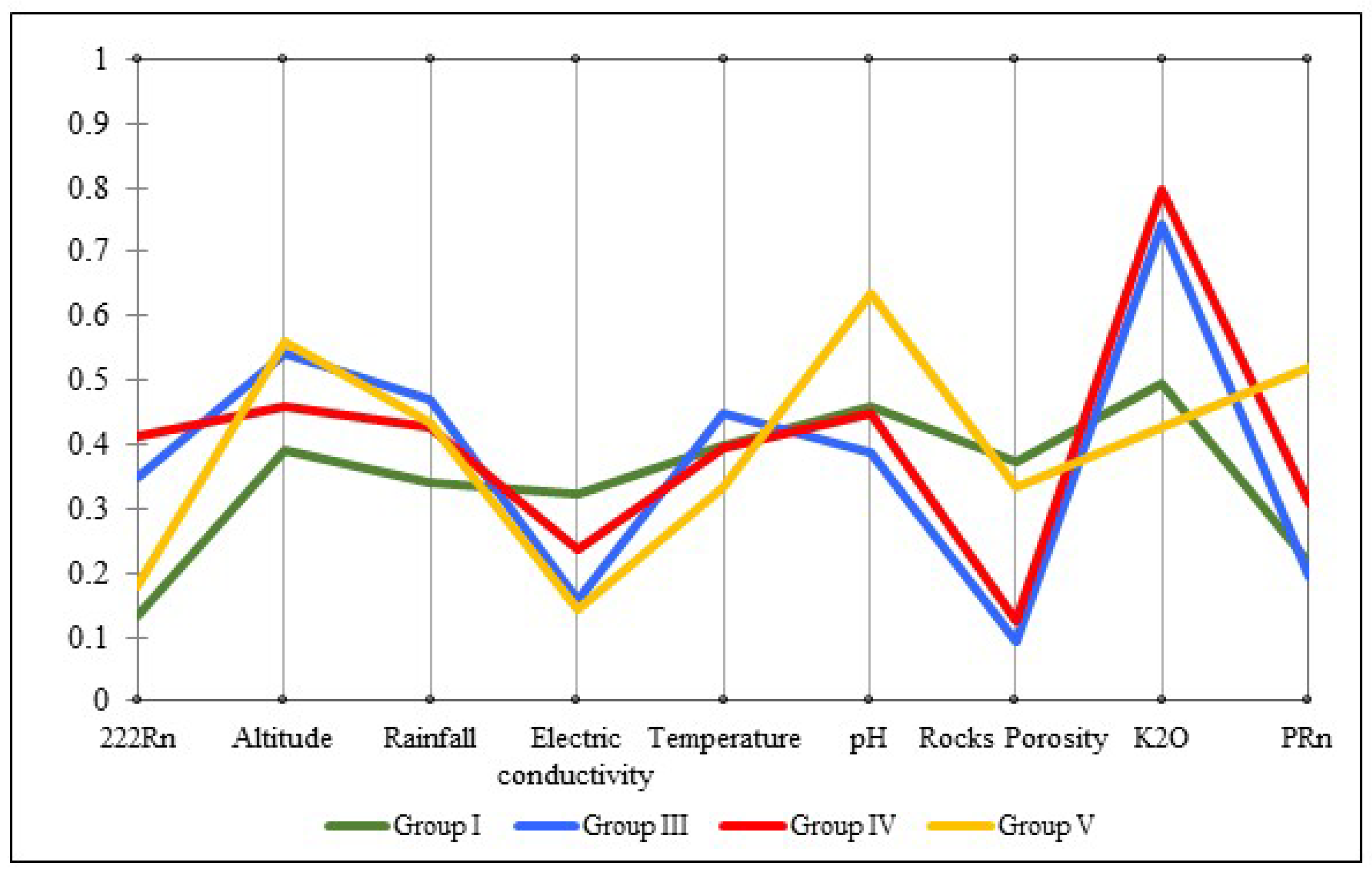
Figure 1. Several hydrogeological, topography, precipitation, and geology networks represented for the studied region: (a) Topography of Iberian Peninsula; (b) digital elevation/drainage network models of studied region; (c) distribution of mean annual precipitation in millimeters between 1960 and 1991, [6]; (d) simplified geological map of studied area, based on the Geological map of Portugal, scale 1:500,000 and 1:50,000 in the influence areas of the geological maps 10B (Vila Real) and 6D (Vila Pouca de Aguiar) [33]; and (e) aquifers type, [34].
Water 11 00760 g001
Figure 2. Technical workflow specifically designed to implement a Portuguese Action Plan for radon (PAPR) in aquifers systems. NWP is the National Water Plan, HRMPs are the Hydrographic Region Management Plans, and SWMPs are the Specific Water Management Plans. The details on the workflow are presented in Section 2.6 described above.
Water 11 00760 g002
Figure 3. The geogenic interpolated maps from rocks: (a) Rocks porosity, (b) K2O contents, and (c) radon production potential [36]. These maps were digitally sampled in ArcMap [45] using the Topo to Raster tool and the Extract Multi Values to Points tool, as to obtain the values of all features for each water collection point.
Water 11 00760 g003
Figure 4. The distribution of dissimilarities results through parallel coordinate visualization plots (PCV).
Water 11 00760 g004
Figure 5. Comparison between interpolated distributions of radon and land-use map: (a) Radon risk map for drinking water with the projection of population density; and (b) land-use map with water collection points through graduated values.
Water 11 00760 g005
Figure 6. Average radon concentrations for several land-use areas.
Water 11 00760 g006
Figure 7. Evaluation of annual effective dose from drinking water consumption: (a) Annual effective dose from radon ingestion; (b) annual effective dose from radon inhalation; (c) number of observations for inhalation and ingestion effective dose above average worldwide; and (d) distribution of observations by groups from inhalation effective dose above the average worldwide.
Water 11 00760 g007
Table 1. Descriptive statistics for climatic, topographic, physical and chemical characteristics, and radiological parameters in water for each geological group.
Geology GroupsStatistics Criteria222Rn (Bq L−1)A (m)R (mm)EC (µS cm−1)T (°C)pHP (%)K2O (%)PRn (Bq m−3 h−1)
Group IMean198.2654.91076.2123.615.15.74.54.9160.7
SD240.8213.7436.7105.32.70.42.80.537.4
Median83.0602.01003.058.515.05.73.74.8152.5
Min.14.0384.0453.628.711.54.71.54.295.7
Max.1013.01053.02275.4330.022.36.39.65.7234.2
n2116
Group III Mean493.6760.51307.769.715.75.52.25.3154.4
SD311.982.5295.258.12.70.20.60.236.9
Median441.0760.51299.751.115.25.42.05.3149.7
Min.116.0628.0597.118.112.35.21.64.8100.3
Max.1223.0879.01911.0205.020.86.13.65.7213.5
n14
Group IVMean581.3702.41234.595.115.05.62.55.3189.0
SD387.7191.0202.298.42.80.50.60.281.2
Median588.5729.01263.441.015.25.62.35.4165.9
Min.31.0434.0607.119.110.35.01.74.8110.6
Max.1385.01035.01553.2343.021.36.74.35.7397.0
n2019
Group VMean 261.1773.61245.164.514.36.14.24.8253.0
SD202.3148.5199.142.62.10.31.90.257.8
Median203.5724.51241.654.514.65.93.24.8254.9
Min.46.0478.0833.321.210.75.62.04.6163.0
Max.749.01078.01573.9164.017.86.97.35.3344.5
n1413
222Rn (Bq L−1) is the radon concentration in springs, A is the altitude (m), R is the rainfall (mm), EC is the electrical conductivity (µS cm−1), T is temperature (°C), RP is porosity (%), and PRn is the potential of radon production in rocks (Bq m−3 h−1).

