Article

Effects of Urban Forms on Separate Drainage Systems: A Virtual City Perspective

1
School of Environment, Tsinghua University, Beijing 100084, China
2
Unit of Environmental Engineering, University of Innsbruck, 6020 Innsbruck, Austria
3
China Minsheng Banking Co., Ltd., Beijing 100031, China
*
Authors to whom correspondence should be addressed.
Water 2019, 11(4), 758; https://doi.org/10.3390/w11040758
Submission received: 23 January 2019 / Revised: 20 February 2019 / Accepted: 9 April 2019 / Published: 11 April 2019
(This article belongs to the Special Issue Urban Water Management and Urban Flooding)

Abstract

:
The development of urban drainage systems is challenged by rapid urbanization; however, little attention is paid to the urban form and its effects on these systems. This study develops an integrated city-drainage model that configures typical urban forms and their associated drainage infrastructures, specifically domestic wastewater and rainwater systems, to analyze the relationship between them. Three typical types of urban forms were investigated: the square, the star, and the strip. Virtual cities were designed first, with the corresponding drainage systems generated automatically and then linked to a model herein called the Storm Water Management Model (SWMM). Evaluation was based on 200 random configurations of wastewater/rainwater systems with different structures or attributes. The results show that urban forms play more important roles on three dimensions of performance, namely economic efficiency, effectiveness, and adaptability, of the rainwater systems than of the wastewater systems. Cost is positively correlated to the effectiveness of rainwater systems among the different urban forms, while adaptability is negatively correlated to the other two performance dimensions. Regardless of the form, it is difficult for a city to make its drainage systems simultaneously cost-effective, efficient, and adaptable based on the virtual cities we investigated. This study could inspire the urban planning of both built-up and to-be-built areas to become more sustainable with their drainage infrastructure by recognizing the pros and cons of different macroscale urban forms.

1. Introduction

China’s large-scale urbanization means rapid growth of urban drainage infrastructures; the length of urban drainage pipes in urban areas increased dramatically by an average of 19.2% per year from 2000 to 2016 [1]. There is a requirement to use separate drainage systems for all newly developed areas, and existing combined sewer systems are encouraged to transform into separate ones, according to the relevant national regulation in China issued in 2013 [2,3]. However, in many Chinese cities, drainage systems experience a number of problems or challenges. The first concerns economic feasibility, as the cost of drainage constitutes a considerable expense for cities, especially small cities focusing on infrastructure. From 1981 to 2016, investments in drainage systems accounted for an average of 7.7% of fixed asset investments in urban service facilities nationwide, which ranks fourth among 10 facilities, i.e., only below roads and bridges, rail transit systems, and water supply. This percentage is even higher in small cities (14.42%) than in medium- and large-sized cities (9.04%) [1]. The second problem concerns effectiveness. Deposition in drainage pipes is common according to monitoring tests of some pipes that were used for several years [4], and this negatively impacts the performance of wastewater pipes. In rainwater systems, urban flooding is a serious problem; 176 Chinese cities, accounting for 27% of all prefecture-level and county-level cities in China, experienced water-logging at least once from 2010 to 2017 [5]. The third problem concerns the adaptability of the fixed drainage systems to various future conditions mainly driven by urban growth [6,7,8,9] and climate change [10,11,12,13].
As one of the major driving forces, urbanization tends to worsen the performance of drainage systems as the urban form changes. Typical characteristics of urban form change include the increases of both the constructed area and its impervious fraction, which lead to a larger volume of urban flooding [14,15] and higher urban water pollutant loads such as TSS (total suspended solids) and NH4-N [16]. In addition to the impervious fraction, other relevant characteristics, such as allotment geometry and roof area can be conceptualized by a newly developed software that performs refined simulation and management of urban water systems [17]. Further, with a newly developed urban development model that relies on minimal data, the population distribution and building attributes could be simulated and easily interlinked with urban water models; an application of the technology to the city of Innsbruck shows that an analysis of numerous spatial scenarios is accessible and necessary, which enables pro-active adaptation or (if possible) the option to prioritize the development of some areas, which put less stress on the existing network [18]. In addition, to analyze the effects of urban form on urban water systems, the results of Mikovits et al. [19] showed that reasonable spatial planning can reduce the negative effects caused by population growth on drainage system performance, which indicates the potential effects of urban form on drainage systems. Applying water-sensitive urban design (WSUD) in Australia, researchers found that green technologies should also be regarded as an integral part of the urban form [20]. The concepts of green infrastructure (GI), low-impact development (LID), and sustainable urban drainage system (SUDS) as the methods to reduce runoff and mitigate the negative effects of urbanization received lots of research attention [21,22]; since these green measures could provide hydrological and bioecological benefits on different spatial scales, there are, thus, additional challenges in the planning of these measures [23]. However, it is worth noting that the concept “urban form” involved in the abovementioned studies adopted a point of view at the micro or the medium level (i.e., related to buildings, parcels, or blocks) and there is little research that considers a city as a whole and investigates its spatial characteristics in relation to urban drainage systems [24].
As cities grow larger worldwide, it could bring both the benefits and the costs associated with the scale of cities [25], which become a major concern in urban planning. The relationship between macroscale urban forms, namely the physical contour of the urban built area, and the atmospheric environment or its related carbon emission or energy consumption, is already widely researched. Most of those studies focused on the form of a compact city, which is characterized by high residential density and mixed land use. Comparing based on sprawl pattern, the compact form will have a positive impact on the reduction of energy consumption, carbon emission [26], and air pollution [27,28]. However, some studies drew a different conclusion, e.g., compact development will increase the concentration of PM2.5 in local hotspots [29]. Among the effects of macroscale urban forms on water systems, the distribution system received some research attention. Results show that the radial/monocentric combination and the physical topology of traditional gridiron neighborhoods have lower energy requirements for the water supply system [30,31], compared to other urban forms involved. Analyzed from the perspective of urban form expansion, another study concluded that the best cost–benefit performance of a water distribution system occurs under uniform expansion, regardless of the population growth rate or whether the system is reformed [32]. However, to our knowledge, there are only few studies that considered drainage systems and macroscale urban forms, even though the features of urban forms play decisive roles in the scale and spatial structures of drainage systems. Therefore, this is the subject matter of this study.
Some of the studies cited above focusing on the urban form and its environmental effects were not based on empirical research on actual cities, but were based on either a spatially explicit theoretical model [33] or an artificial framework of the urban forms [34]. This kind of theoretical or virtual approach may decouple results from location-specific characteristics and, thus, may make it possible to analyze how different elements related to urban planning and population distribution affect the environment [33]. In studies concerning water distribution systems, this virtual approach is applied frequently due to the paucity of published water distribution system models and the low availability of data due to security reasons. Currently. there are several algorithms or software creating benchmark virtual networks stochastically, e.g., Modular Design System [35], WaterNetGen [36], Virtual Infrastructure Benchmarking (VIBe) [37], each of which has its specific advantages [38]. For its application with urban form, some typical patterns, such as gridiron, radial and satellite [31], compact/uniform, monocentric, polycentric, and edge developments [32], are set up during the artificial design process of the physical configuration of pipes along with the spatial distribution of water users. To simulate drainage systems, the VIBe model was applied to generate virtual cities of varying sizes and simulate its impact on combined sewer overflows (CSO) and flooding [39].
Here, we develop an integrated model based on the virtual city concept to investigate the relationship between the macroscale outer contour of the urban form and the performance of urban drainage systems. The three main parts consist of the virtual city design, drainage system generation, and drainage performance simulation. Separate wastewater and rainwater systems are generated independently, and, in the following text, the wastewater and rainwater systems are abbreviated as WS and RS, respectively. System performance was measured in terms of its economic efficiency, effectiveness, and adaptability, where the last two aspects used different indicators of the two separate systems. In the end, an evaluation and a comparison of the two drainage systems’ performance under different urban forms were conducted.

2. Materials and Methods

There are two general principles when designing virtual cities and corresponding drainage systems. Firstly, all the parameters and assumptions should reflect the reality of Chinese cities and current drainage systems. Here, the word “reflect” does not mean “exactly the same”, because cities have numerous attributes with large degrees of diversity, some of which are hard to measure or count. For example, a wastewater treatment plant is generally located downstream, but its actual position depends on many influencing factors and is very hard to pinpoint. Therefore, the term “reflect” here means that all the parameters and assumptions in this study are reasonable and not against any current Chinese standard or common knowledge in this field. Secondly, the virtual system should be simplified as much as possible on the premise of the first principle. This simplification mainly includes unifying some parameters or assumptions and selecting values or attributes that are relatively easy to calculate. For example, the position of a wastewater treatment plant should be at the lowest area that is a corner of the virtual city, according to the set uniform slope. Moreover, the receiving water body is assumed to be a straight river alongside the virtual city; the situation where the river crosses through a city receives no special consideration because the city could be regarded as two independent systems on each side of the river.

2.1. Virtual City Design

2.1.1. Forms of the Virtual Cities

Since cities differ greatly in terms of urban form, a large array of classifications of urban form can be found in the literature. Milder [40] summarized the various classifications roughly into seven typologies, i.e., dispersed city, compact city, corridor/linear/radial city, multi-nuclear/polycentric city/edge city, fringe city, edge city, and satellite city. From the perspective of physical configuration, Besussi et al. [41] classified urban forms into four types, i.e., compact contiguous, linear strip corridor, polynucleated nodal, and scattered/discontiguous.
According to Wu [42], Chinese cities can be divided into two categories: centralized cities and group cities. The former category, which is the focus of this study, is divided into three typical types: block, strip, and star, based on the outer contours. As these studies only provide theoretical support, we looked into the actual built-up areas of 276 Chinese cities for the year 2015, and found corresponding cities for all the three form types. Some cities with these three typical forms are shown in Figure 1a. Based on these findings and the simplicity principle, this study used three typical shapes as the forms of the virtual cities. The first is the square, which is the most typical and regular graphic, and indicative of the block form. The second is the rectangle, with a length-to-width ratio of 25:4, which indicates a common strip form. The third form resembles a maple leaf (see Figure 1b) and indicates the star form. Using these three outer forms, three virtual cities were designed in this study, and they are named The Square, The Strip and The Star.
This study focused only on the effects of urban contour forms on separate drainage systems, and all other factors were assumed to be equal. Thus, other features that may contribute to urban forms, such as population distribution patterns and terrains, are not considered here and they are assumed homogeneously in every location of all the three virtual cities for simplicity.

2.1.2. Scale and Natural Conditions of the Virtual Cities

The scale of the virtual city was based on small cities in China. This choice was dictated by multiple reasons. Firstly, Sitzenfrei et al. [39] drew a conclusion that water infrastructures of smaller cities are more affected by condition change compared to medium-sized and larger cities. Secondly, in China in the period 2010–2015, the increase in underground pipeline length and sewage treatment capacity was higher in county-level cities (mainly small- and medium-sized cities) than that of prefecture-level cities (mainly medium- and large-sized cities) [1], and small- and medium-sized cities are planned to develop even faster to 2020 according to China’s 13th five-year plan. Thirdly, traditional drainage systems will continue to play dominant roles in smaller cities in the near future because distributed low-impact development (LID) measures were not planned there [43]. Moreover, the urban forms and drainage systems in small cities are relatively simple, making it more suitable to study the relationship between them. According to the statistical results of the small cities with populations ranging roughly from 200,000 to 500,000 in 2015, the virtual city used in this study has an area of 36 km² and a population of 360,000. The three urban forms mentioned above are set in the virtual city (see Figure 1b).
In order to exclude the influence of terrain, we assume a nearly flat ground with only a small slope of 0.01%, which enables runoff to flow into pipes; however, this may produce the need for pumping stations. The water body is set along the longest side of each virtual city, since cities are usually built and developed alongside a river.

2.1.3. Blocks and Drainage Units

Each virtual city is composed of 400 uniform blocks of 300 m × 300 m, since this is the common size and shape of a block in Chinese cities located in the plain. Residents are evenly distributed among all the blocks. Each block has three drainage units (DU), containing one core DU and two road DUs (see Figure 1c), and the area distribution is set according to the Code for Classification of Urban Land Use and Planning Standards of Development Land in China [44]. Based on the composition of surfaces with different imperviousness rates in ordinary Chinese cities, all of the 400 core DUs were divided into three groups of 260, 120, and 20 DUs with runoff coefficients of 0.2, 0.6, and 0.7, respectively. The runoff coefficient of road DUs is 0.9 [45].
Usually, the layout of the rainwater pipe network is closely correlated with the road network [46], since runoff is produced on the surface almost everywhere and it is necessary to build the pipes underneath all the roads. It is natural that the runoff from a particular zone is collected by the nearest pipe situated at a lower location. On the other hand, the residential wastewater is a kind of point source. The aim of the wastewater pipe network is to collect wastewater from all discharge points, making it unnecessary to build pipes underneath all roads. Moreover, the flow direction of wastewater does not necessarily follow the slope, especially if the slope is small. Based on this knowledge, we set the wastewater from a core DU to flow to any one of four surrounding roads randomly, while the runoff from a core DU flows to the road closest to the receiving river and the runoff from a road DU flows to itself. The attributes of drainage units are shown in Table 1.

2.2. Drainage System Generation and Performance Simulation

Before drainage system generation, the number and position of the wastewater treatment plants (WWTP, for the WS) and outfall points (for the RS) have to be set because they are the starting points for a whole pipeline network. As introduced in Section 2.1, one WWTP is located at the topographically lowest corner of each virtual city. It is feasible that such a city containing 360,000 residents uses only one WWTP designed to handle a flow smaller than 100,000 m3 per day, which is a common size for Chinese WWTPs. For the RS, we set ten outfalls which are uniformly located along the river side of the city, dividing the city into ten equal and vertical drainage zones to the river. The area of a single drainage zone is 3.6 km2, and 10 outfalls enable all three cities to be evenly and vertically divided.
The three main steps involved in generating the whole pipeline networks for both drainage systems are (i) network layout determination, (ii) hydraulic calculation of the pipes, and (iii) pump setting. For layout determination, we use the Kruskal algorithm [47], which seeks only one minimum tree with a starting point at the WWTP and the outfalls traversing all the needed roads. Considering the water flow from every DU and the connection of pipes, the velocity, diameter, and slope of each pipe are calculated according to the current code for outdoor drainage engineering design in China [45]. Pumps are set only when the burial depth of the pipe outlet is more than 7 m [48].
According to the assumptions set in Table 1, for each kind of drainage system, there is a variable deciding the final generation result of the pipe networks. For WS, the variation arises from the connected road randomly chosen by every core DU; thus, the network layout changes every time the connected roads change. For RS, the variation arises from the various spatial distributions of three types of core DU; thus, the hydraulic calculation result of pipes changes every time the spatial distribution changes. As a result, for the city of each form, the generation of a pipeline network is conducted a number of times before the means of every performance indicator (which will be introduced in the next section) do not change significantly.
A widely used urban water management model, SWMM (Storm Water Management Model) [49], was connected to simulate the hydraulic performance of the two drainage systems separately every time a whole wastewater system and a whole rainwater system is generated. The generation of the drainage systems is automatically accomplished through Matlab, as well as its connection with SWMM. The Matlab code automates the process of writing and reading the input files, running the software, reading the output files, and extracting the simulated results of SWMM.
The Horton infiltration model and the dynamic wave routing model are used for the hydraulic simulation in SWMM [49]. The infiltration parameters are calibrated according to the assumptions set on DUs before running the model. The simulation time for WS is 24 h, which indicates a whole day, while, for RS, the rainfall events last for two hours and the simulation time is four hours. The time step for reporting the results is five minutes. Other main settings and parameters used in this research are shown in Table 2.

2.3. Evaluation of Drainage System Performance

Three criteria, namely economic efficiency, effectiveness, and adaptability, are applied to evaluate the performance of both drainage systems.

2.3.1. Economic Efficiency

The total cost of the system is calculated as its economic efficiency. The total cost (Cost) is defined as the sum of the construction cost (CC) and the operation and maintenance cost (OMC) after discounting, as shown in Equation (1), where r denotes the discount rate and t is the discount time, set at 6% and 30 years, respectively. For both the WS and the RS, the construction costs include the pipeline network and pumps (if they exist), and, for the WS, the cost of the WWTP is also included, as shown in Equations (2) and (3).
C o s t = C C + ( ( 1 + r ) t 1 ) / ( r × ( 1 + r ) t ) × O M C ;
C C = C C p i p e + C C p u m p + C C W W T P ;
O M C = O M C p i p e + O M C p u m p + O M C W W T P .
The construction cost and the operation and maintenance cost of pipes, pumps, and the WWTP are calculated according to Wang [52] and Liu et al. [53].
C C pipe = N p i p e ( ( 34.4 + 8.8 H + 1.0 H 2 + 121.1 D × H + 180.7 D 4.31538 ) × L ) ,
C C p u m p = N p u m p 79 , 418.5 H p u m p × Q p u m p 0.52 ,
C C W W T P = ( 0.0053 Q W W T P 2 + 1.1202 Q W W T P + 1.5011 ) / 10 7 ,
O M C p i p e = 0.03 C C p i p e ,
O M C p u m p = 0.03 C C p u m p ,
O M C W W T P = 0.8217 × Q W W T P 0.2397 × Q W W T P × 365 / 10 4 ,
where H denotes the depth (m), D is the diameter (m), L is the length (m), Npipe is the number of the pipes, Hpump denotes the lifting height (m), Qpump represents the design flow (L/s), Npump is the number of the pumps, and QWWTP denotes the design flow of the WWTP (104 m3/d). The unit of all kinds of cost is Chinese yuan.

2.3.2. Effectiveness

Based on the simulated results from the SWMM, we set two indicators for each of the two systems to evaluate their respective hydraulic performance based on current conditions. For the WS, since the deposition-related problems of pipes suggest frequent low water flow inside the pipes [54], and since extremely high water flow is also harmful to the pipe network, the capacity of the pipes, here defined as the fraction of the full area filled by flow for conduits suggested in the SWMM user’s manual [49], and the velocity of water flow inside the pipes are computed. We calculate the percentage of the pipes whose capacity exceeds 75% at least once during the 24 h, and the percentage of pipes whose flow velocity is less than 0.6 m/s constantly for one day. These two percentages are defined as capacity failure (Cf) and velocity failure (Vf) indicators, respectively. For the RS, we focus on local flooding under rainfall events with different return periods of 1, 2, 3, 5, 10, 20, 50, and 100 years. The other parameters of the rainfall events are consistent with the designed one, and it rains for two hours with the peak position coefficient 0.35. We calculate both the number of the flooded nodes and the flooding volume of all flooded nodes during the eight rainfall events. The final indicators are calculated as the sum of each individual indicator with the reciprocal of the return periods used as weights, and the named number of flooded nodes (N) and quantity of flood (Q, m3), calculated as follows:
N = i R P 1 i N i ,
Q = i R P 1 i Q i ,
where RP = {1, 2, 3, 5, 10, 20, 50, 100}.

2.3.3. Adaptability

Once a drainage system is constructed, it is not easy to replace or rebuild it during its entire life span. Thus, it is important to build a drainage system with a capacity to adapt well to uncertain conditions in the future. The quantity of wastewater discharge will face multiple influencing factors such as climate change, population change, and water consumption behavior change. Moreover, actual rainfall events will not always be consistent with the designed one. In order to simplify measurements, we set different scenarios for the two systems. For the WS, the wastewater change coefficient is set to an upper value of 1.5 and a lower value of 0.5, which will be used to multiply the 24-hour wastewater discharge, doubling or halving the discharge. For the RS, we change the peak position coefficient, which is a parameter in the Chicago rain pattern formula that ranges from 0 to 1, deciding when the maximum precipitation occurs during a rainfall event. Based on previous research showing that the closer it is to 1, the more intensively the rainfall may strike the system [48], we set the value to 0.5 to represent the adverse scenario in this study.
We use the proportions of the effectiveness indicators (Cf, Vf, N, and Q) under changing scenarios and the baseline scenario as the adaptability indicators, named Cf_Adapt, Vf_Adapt, N_Adapt, and Q_Adapt, respectively. In particular, capacity failure and velocity failure correspond to the wastewater discharge change oppositely. The greater the wastewater discharges, the higher the flow capacity and the faster the velocity become; additionally, the likelihood for the capacity to fail is greater, but the likelihood for the velocity to fail is lower. Therefore, we only consider the high-discharge scenario for Cf and the low-discharge scenario for Vf. For both the WS and the RS, the larger these indicators are, the less adaptability the system has.

3. Results and Discussion

In this section, the results of the three dimensions including the economic efficiency along with the pipe network structure, the effectiveness, and the adaptability for both WS and RS are described and discussed, and a comprehensive evaluation of both systems is conducted at the end of this section.

3.1. Structure and Economic Efficiency

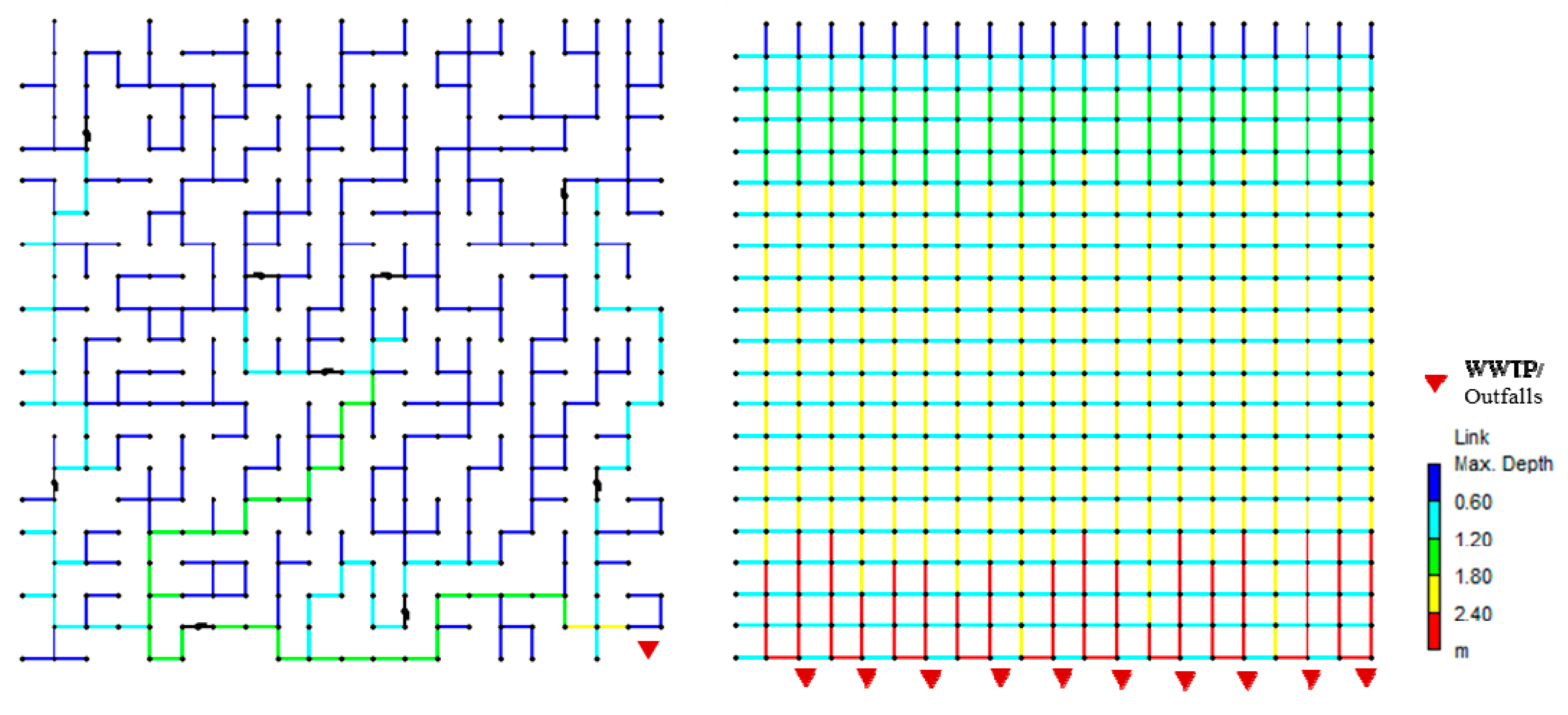
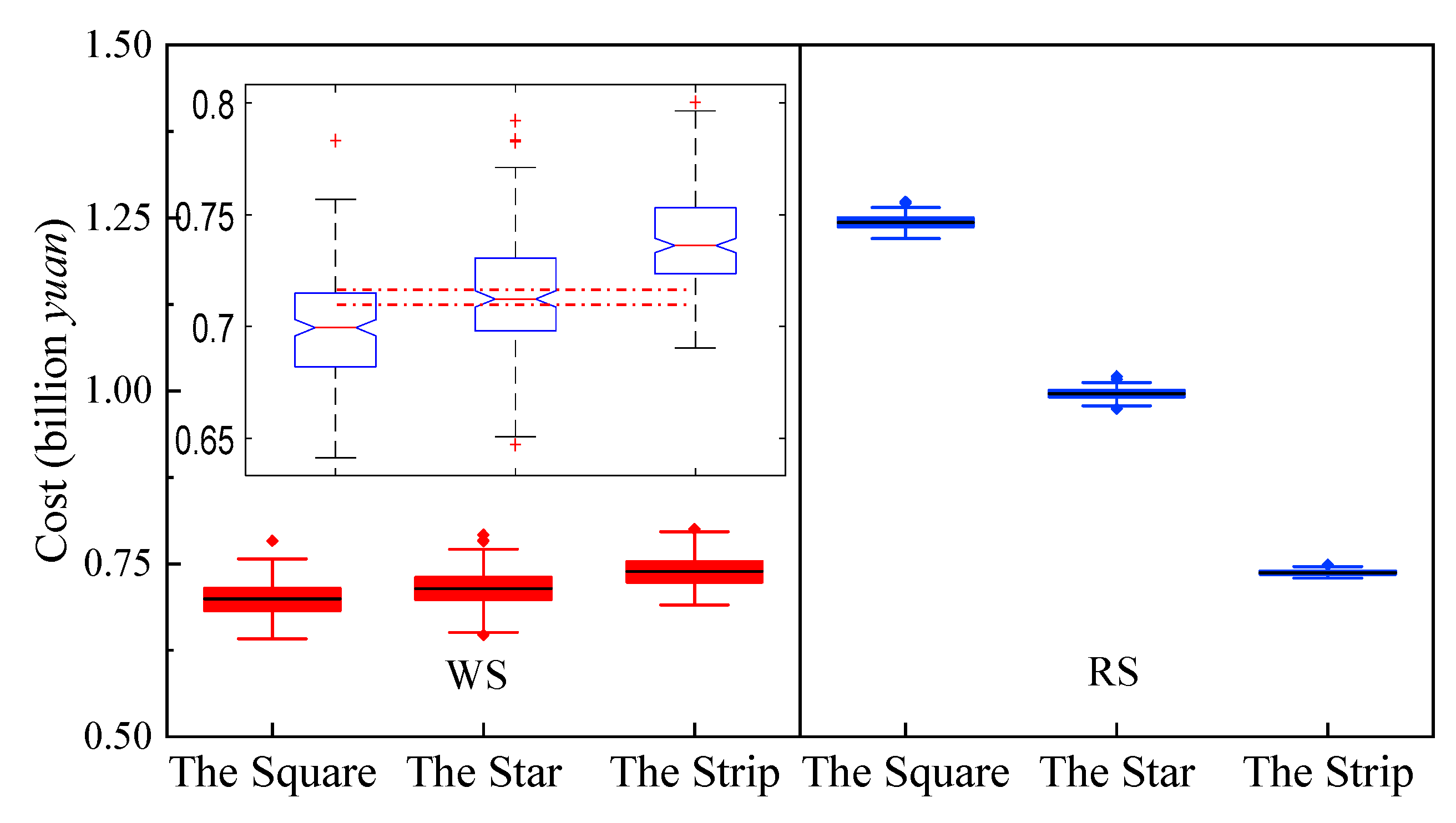
For each virtual city, simulation and indicator calculations are implemented 200 times for both the wastewater and the rainwater systems, since the relative errors between the means after each round of calculation and the mean of all 200 times are constantly below 0.005 before 200 times for all indicators. One of the drainage generation results of The Square can be found in Figure A1 (Appendix). Other wastewater pipeline results have different layouts of pipes from this one, and other rainwater pipelines are generated with the same layout but possess different attributes compared to this one. The WS always has much fewer pipes than the RS, because the rainwater pipes are under all roads, while the wastewater pipes only exist when it is necessary to build a pipe to receive the discharge or link two pipes. The diameters of the wastewater pipes are generally smaller than those of the other system due to the difference between the wastewater flow and the runoff when the area is fixed. Such structural differences between the RS and the WS are also applicable in The Star and The Strip cities. The consequence of this structural difference between the two kinds of drainage systems is the difference in economic efficiency, as shown in Figure 2. The total costs of wastewater systems lie within the range of 0.65 to 0.8 billion Chinese RMB yuan (equivalent to 94 to 116 million United States (US) dollars), regardless of the urban form. However, the lowest cost associated with the RS in The Strip is similar to the mean cost of the WS, and the RS costs more than the WS, especially for The Square and The Star.
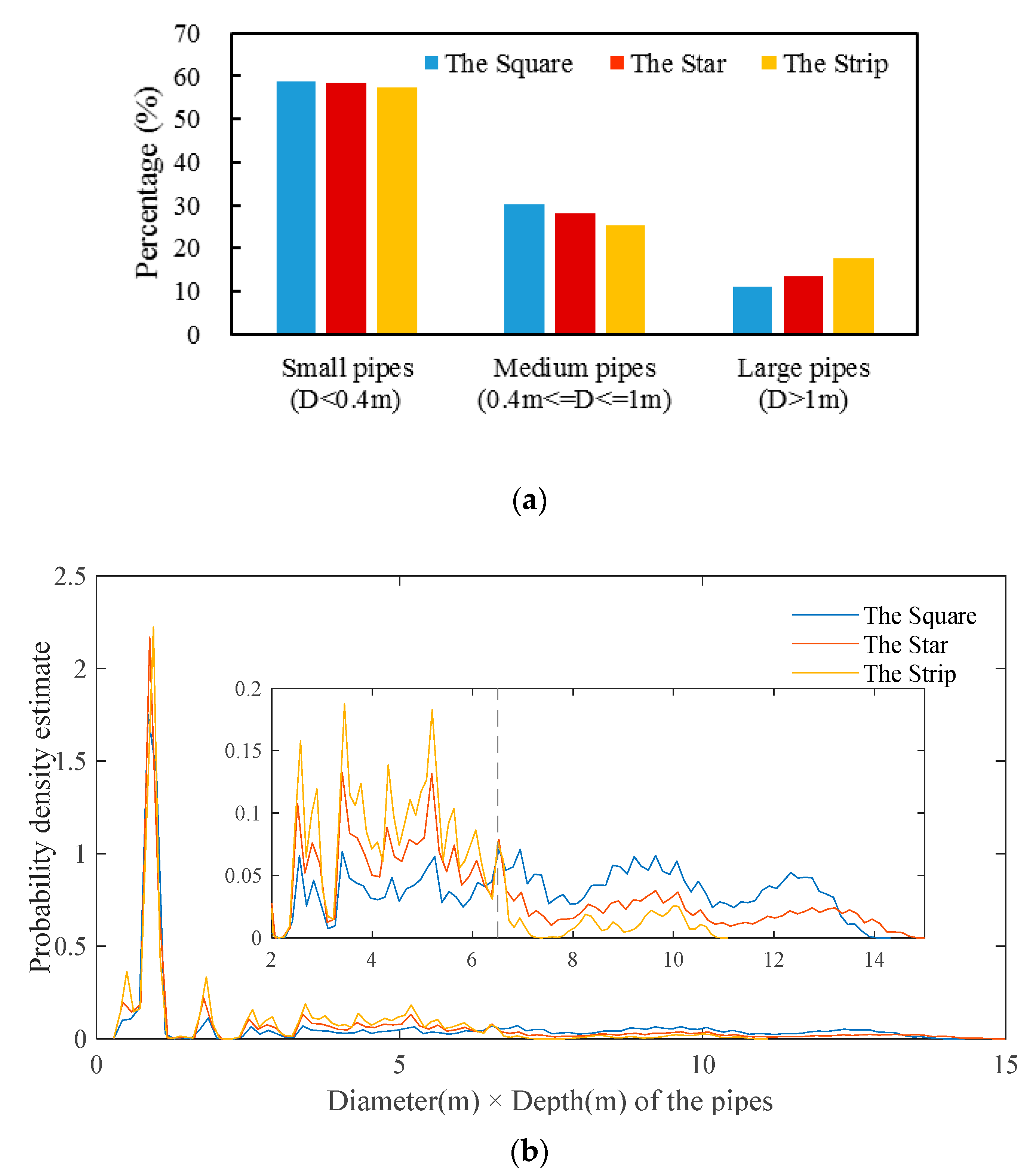
The Kruskal–Wallis test for independent samples and the median test for both drainage systems suggest that the difference in cost among the three forms is statistically significant (p < 0.01), and the pairwise comparisons suggest that the costs among the three forms are statistically different from each other (Adjusted p < 0.01), for both drainage systems. However, the difference between the WS forms is not as apparent as that of the RS, as shown in Figure 2. The two drainage systems of the three urban forms have opposite cost trends. Considered in the order of The Square, The Star, and The Strip, the total cost of wastewater system increases while that of rainwater system declines. For the WS, the cost difference is mainly due to the pipeline network other than the WWTP, since the cost of WWTP does not vary because the total wastewater discharge is fixed. However, because the WWTP is located at a corner of the city, The Strip has the longest transport path for water flow, which leads to larger and deeper pipes, especially in the downstream portion. As Figure 3a shows, considering the percentage of the pipes that are larger than 1 m in diameter, on average, The Strip has 6.4% more pipes than The Square. As a consequence, The Strip requires the most expensive wastewater system compared to the other forms.
For the RS, we used the Kernel smoothing function, a non-parametric way to estimate the probability density of a variable [55], to quantify the probability density of the pipe diameter multiplied by the depth of all pipes. As Figure 3b shows, for the very small or shallow pipes that are usually at the start of the pipe networks, the difference in probabilities among the three forms is not apparent. However, the probability difference tends to increase as this variable increases. The probability curve of The Square is the flattest among the three curves, while that of The Strip declines sharply from the highest to the lowest when the variable reaches 6.5. This indicates that The Square has the largest number of large and deep pipes, thus leading to its highest cost, while The Strip has the opposite attributes. Since the outfalls are uniformly located along the longest side of the city and the main pipes stretch vertically along this side from the outfalls, the distance from the opposite side to the water body side plays the key role in determining the diameter and depth of the pipes. The Strip has the shortest distance, resulting in the cheapest rainwater system, while The Square has the most expensive system; The Star is intermediate between the other two.

3.2. Effectiveness

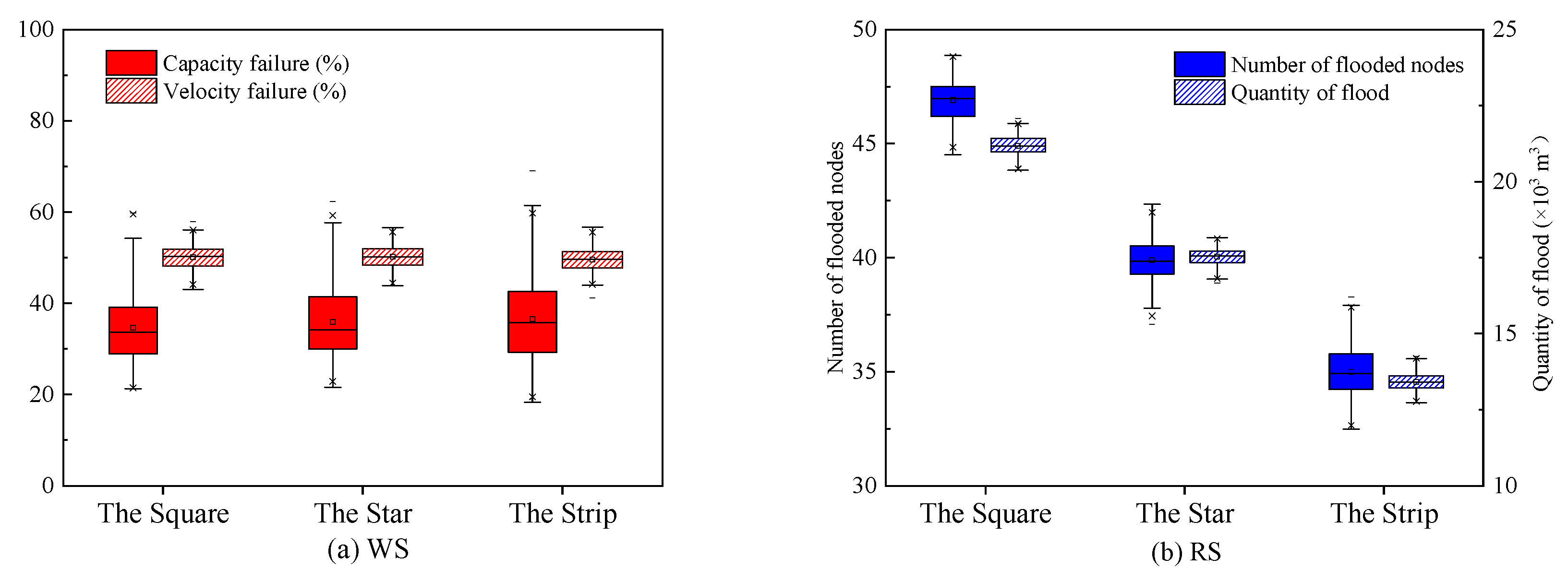
The effectiveness indicators of the two drainage systems differ according to the three urban forms, as Figure 4 shows. For the RS, the differences involving the number of flooded nodes and the quantity of flood are significant (p < 0.01); however, for the WS, both Cf and Vf fail the Kruskal–Wallis statistical test. Regardless of the urban form, for the WS, the percentage of pipes that fail in terms of capacity is in the range of 30–40%, while the percentage of pipes that fail in terms of velocity is higher, within the range of 47–53%. This indicates that urban forms have limited influence on the pipe effectiveness for the WS.
For the RS, the size relationships of the effectiveness indicators under the three urban forms are basically consistent with those of economic efficiency, and the changes in the number of flooded nodes and quantity of flood occur in the same direction. Compared to the RS of The Square, on average, the RS of The Star and The Strip are 14.9% and 25.4% lower, respectively, in the number of flooded nodes, and 17.2% and 36.7% lower, respectively, in the quantity of flood. The difference in the quantity is larger than that of the number.
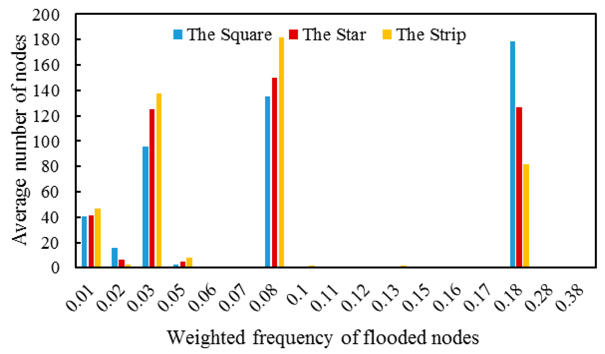
To conduct a more in-depth analysis of the results, the numbers of flooded nodes with different sums of weighted frequencies of the eight rainfall events are counted for each city. The weights of each flooded node are the reciprocals of the eight return periods (1, 2, 3, 5, 10, 20, 50, and 100), which are consistent with those of the effectiveness indicators. Based on the results, there are, in total, 17 discrete weighed sums, and the average number of the flooded nodes of the 200 configurations with different sums for each urban form is shown in Figure 5. Generally, The Square has the least number of low- and medium-frequency (weighted frequencies lower than 0.17) flooded nodes but the most high-frequency (weighted frequencies higher than 0.17) flooded nodes, and its average number of high-frequency flooded nodes is more than two times higher than The Strip. This indicates that the worst effectiveness of The Square in the RS is due to its largest number of flooded nodes during the lighter rainfalls, rather than its vulnerability to the rainfall events of larger return periods. This result could also be traced into the structural difference of the pipe networks among the three urban forms. As mentioned in the previous section, The Strip has the shortest distance from the opposite side to the water body and, thus, the shortest length for main pipes of the RS, while The Square has the longest ones. When the rainfall is above the design return period, the downstream pipes of The Square are filled rapidly, thus creating a backwater effect in the upstream nodes and subsequent flooding. However, when the rainfall is heavy, there would be little difference among the RS of the three forms as the pipes are filled almost uniformly. That could be the reason for the similar trend of costs and effectiveness among the three forms for the RS.

3.3. Adaptability

The adaptability results are shown in Figure 6, and all the indicators among the three forms differ significantly based on the Kruskal–Wallis test (p < 0.01) for both drainage systems.
For the WS, when the total wastewater discharge increases by 50%, the average capacity failure values of The Square, The Star, and The Strip are 1.53, 1.48, and 1.46 times higher, respectively, than the baselines, as shown in Figure 6a. When the discharge reduces by half, the velocity failure values of The Square, The Star, and The Strip are 1.31, 1.29, and 1.28 times higher, respectively, than the baselines. The difference between The Star and The Strip for both indicators is minor, but The Strip is inferior compared to the other two, especially for the Cf_Adapt. The results indicate that The Square, which has the best economic efficiency for the WS, has the lowest adaptability to changes. The reason for this could be traced to the structure of the pipe networks (see Figure 3a), which shows that the percentage of the relatively small pipes for The Square is the highest. Since smaller pipes are located in the upstream part of the network and are designed according to the direct inflow from the junctions rather than the water flow of the upstream pipes, they are more sensitive to the inflow changes than larger pipes.
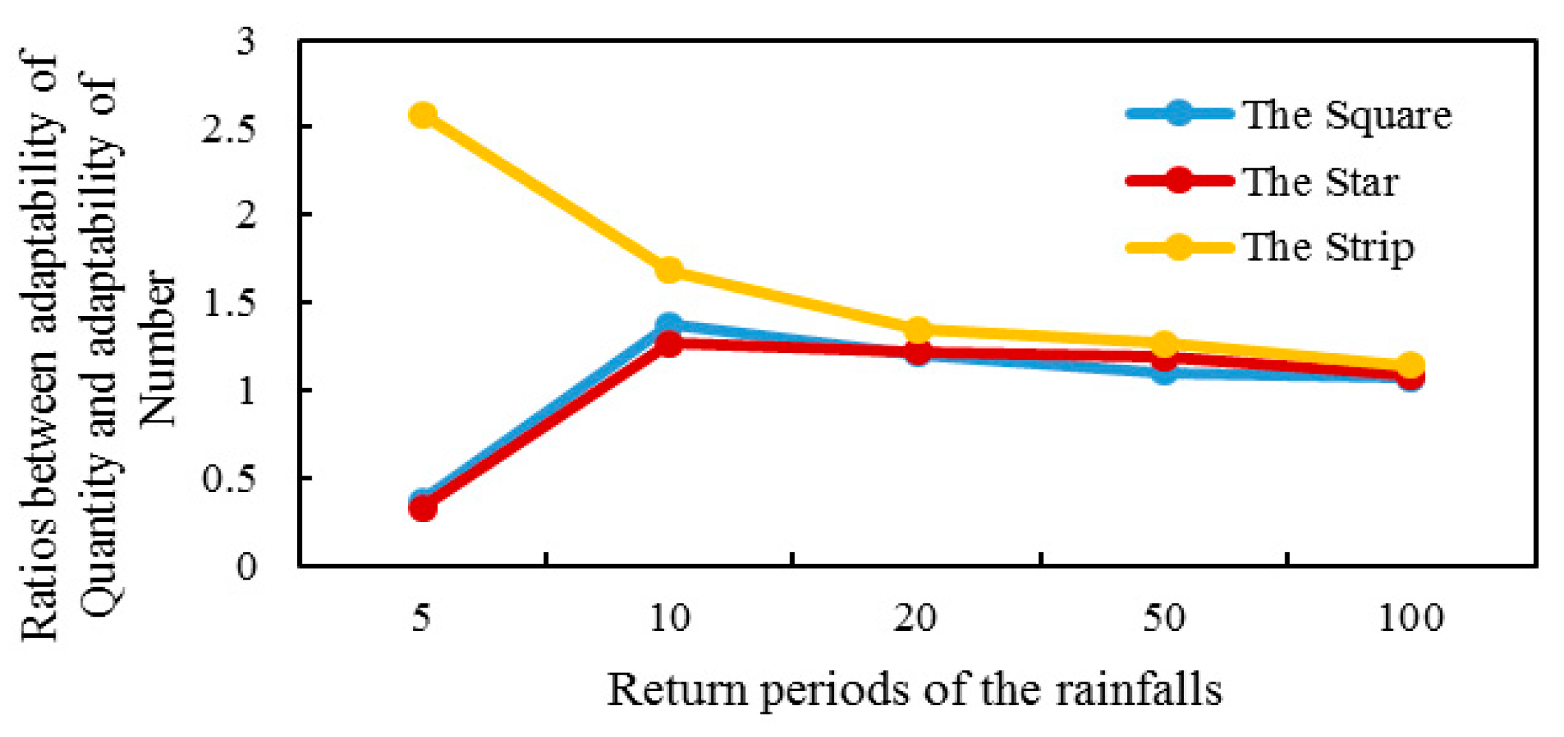
For the RS, when the peak coefficient of the rainfall changes from 0.35 to 0.5, both the number of flooded nodes and flood quantity increase with rates of 30–60% and 40–70%, respectively, as shown in Figure 6b. This increase occurs because, when the rainfall peak moves to a later position, the internal space of the pipes is easier to be fulfilled by the smaller runoff in the initial stage and, thus, it is more likely that the pipes will get overloaded from the peak runoff. Both indicators here show generally contrasting patterns in the three urban forms as compared to economic efficiency and effectiveness, except for N_Adapt of The Strip. The reason for the increasing trend of Q_Adapt under the three forms can be traced to the relationship between the increment of change and its original values. For The Square, although the increment of flood quantity remains the biggest, its largest original value plays a more important role in deciding the quotient, which leads to its relatively better adaptability. For The Strip, although its adaptability on the quantity of flood is the worst, its adaptability on the number of flooded nodes is not. We compared the separate adaptability values of the quantity and the number after the scenario changes under each return period of rainfall that causes flooding (starting from five years). As shown in Figure 7, the ratios of The Strip are always larger than 1 and higher than the other two forms, especially under the five-year rainfall. This indicates that, when the rainfall is heavy enough to cause floods in the RS for The Strip, the move of the peak position will lead to a higher flood volume in the original flooded nodes rather than making more nodes into the flood. The Square and The Star, however, have opposite responses when the rainfall starts to cause a flood.

3.4. Comprehensive Evaluation

For the five indicators above of both the WS and the RS, all 600 results of three urban forms were normalized, and the means of each indicator under each urban form were calculated before being evenly distributed into effectiveness and adaptability, and directly distributed into economic efficiency. The results are shown in Figure 8; the closer the value is to 1.0, the worse the dimension is for the urban form.
On the whole, the effect of the urban form on the performance of the RS is more significant than that of the WS. For the WS, only the economic efficiency shows the most significant difference among the three forms; however, this difference is still smaller compared to all the dimensions of the RS. For the RS, the difference among the three forms in economic efficiency and effectiveness is larger than that of adaptability; in adaptability, The Star and The Strip are more similar to each other.
For the RS, the rankings of the three urban forms on the economic efficiency and effectiveness are relatively consistent; however, the rankings based on adaptability are the opposite to that of the other two dimensions. These results suggest that costs and effectiveness for the RS are positively correlated, but the correlation between adaptability and costs or effectiveness is negative when looking at the type of urban form. This suggests that a city with a certain form may not have an effective rainwater system despite spending much money on it, but it may have relatively good adaptability if the rain pattern changes, and vice versa.
For the RS, The Star has similar performances on all three dimensions; this form performs moderately compared to the other two forms on all dimensions. The Strip is superior to The Square in terms of both economic efficiency and effectiveness for the RS, but their rankings are switched when looking at adaptability for the RS and economic efficiency for the WS. These results indicate that cities with three typical urban forms could face different challenges when constructing and using drainage systems, with the precondition that the other natural or social conditions such as terrains and population densities remain homogeneous. A square-shaped city is likely to suffer from serious urban flooding even though it has to spend much money on the RS, and its wastewater pipes may not work very well when the discharge changes. A strip-shaped city does not face these problems; however, its wastewater system may cost higher compared to the other shapes, and its rainwater system may not adapt well when the rain pattern changes. Although a star-shaped city performs relatively moderately compared to the other two urban forms, it has nearly the worst adaptability to the rainwater system; thus, this urban form will have difficulty dealing with changing conditions. Furthermore, these results also suggest that, regardless of urban form, it is difficult for a city to simultaneously build a drainage system that is cost-saving, effective at the present, and adaptable to changes in the future, under the premise that all the hypotheses in the virtual cities are valid and no green infrastructure is included. In other words, we did not identify the most suitable urban form based on the investigated performances of drainage systems in the virtual cities we defined.

4. Conclusions

This paper analyzes the relationship between urban forms and the performance of separate drainage systems by means of integrated models. Virtual cities with three typical urban contour forms were designed based on a series of reasonable assumptions and feasible pre-conditions. For each virtual city, a number of wastewater systems and rainwater systems were generated automatically following Chinese urban planning and outdoor drainage standards. The performance of each system was then simulated with SWMM. Three performance dimensions, i.e., economic efficiency, effectiveness, and adaptability, were calculated for each system and later compared for each of the three urban forms.
Results show that all three dimensions for the RS differed significantly among the three urban forms, while, for the WS, only economic efficiency and adaptability differed significantly among the forms, even though the difference was not as large as that of the RS. This indicates that urban contour forms play more significant roles in the performance of rainwater systems than on wastewater systems. Cost was positively correlated to the effectiveness of rainwater systems among the different urban forms; however, adaptability was negatively correlated to the other two performance dimensions. For the three urban forms, The Square and The Strip always performed oppositely on all three dimensions of the RS and economic efficiency of the WS, while the RS performance of The Star always ranked intermediately. On the whole, each urban form has its own advantages and disadvantages concerning drainage systems. This study could not identify the best urban contour form that can make drainage systems simultaneously cost-saving, effective, and adaptable to changes.
Although all the numerical results can only be addressed under the conditions we set in the virtual city model, the results may have implications in actual urban planning and drainage design. Cities that used rainwater systems for decades can hardly be expected to reconstruct their underground infrastructures; thus, they need to pay more attention to system adaptability to possible future changes, especially for cities shaped like irregular stars or long strips. Increasing the infiltration rainfall volume and extending the hydraulic retention time before the runoff goes to the pipes are possible measures to improve the adaptability of the rainwater systems. For cities being planned, especially those tending to resemble a square built-up area, the total costs and effectiveness of the rainwater systems should be of great concern; on the other hand, a strip city should pay closer attention to the total costs of the wastewater system. The infrastructure planning of such cities needs to be prepared for high investment and possible failures of the drainage systems. Although this study is based on cities, the basic conclusions and practical implications may also be applied to independent urban drainage zones with equivalent areas and population scales, since these two organizing concepts do not essentially differ when it comes to drainage systems.
As this study only focused on the contour urban forms, some urban attributes that could also affect the performance of drainage systems, such as terrains and population distributions, were excluded from the research. Furthermore, the green infrastructures, being a cost-effective technology for rainwater systems as recognized by many studies [56], were also not considered in this study; the cities with selected urban forms may have different potentials with various green infrastructures either in increasing the economic feasibility and effectiveness in the sewer design stage or improving the adaptability after infrastructure renewal. As a result, it should be noted that all the conclusions in this study are limited to these simplifications, as well as the hypothesis made on the virtual cities.
The critical point of this study may be the usefulness of virtual cities, which relies on a number of assumptions. Whereas cities and urban drainage systems are complex and diverse in reality, any approximation or mapping model cannot be entirely “correct”. The virtual city is useful in this study, as it does not rely on empirical evidence on the relationship between urban forms and drainage performance. Instead, it is an effort to provide a theoretical analysis framework to understand the relationship between urban spatial structures and drainage infrastructures. Since the results show that urban forms do have effects on urban drainage systems, especially rainwater systems, it is worth developing virtual city models in future investigations. This method could be further improved and refined to be more flexible and adaptable to various urban growth scenarios, as well as green infrastructures.

Author Contributions

N.J. designed the study, performed the analysis, and wrote the original draft; R.S. helped in improving the model, analyzed the results, and reviewed the writing; W.R. helped in analyzing the results and reviewed the writing; S.L. performed preliminary calculations of the wastewater system; Y.L. supervised the work and helped in editing the manuscript.

Funding

This research was funded by the National Natural Science Foundation of China (No. 71473148), and “12th Five-Year” Major Science and Technology Program for Water Pollution Control and Treatment: “Integration of Urban Water Pollution Control and Water Treatment Technology” (No. 2014ZX07323001). The work of the University Innsbruck in this research was funded by the Austrian Science Fund (FWF): P 31104-N29.

Acknowledgments

The authors would like to acknowledge Hua Bai, Dazhen Zhang, and Zhiwei Xu for their support provided for the model. We are also grateful to the anonymous reviewers for their useful comments and suggestions.

Conflicts of Interest

The authors declare no conflict of interest. The funders had no role in the design of the study; in the collection, analyses, or interpretation of data; in the writing of the manuscript, or in the decision to publish the results.

Appendix A

Figure A1. One pipeline network of the WS (left) and one of the RS (right) for The Square.
Water 11 00758 g0a1

References

  1. Ministry of Housing and Urban-Rural Development of the People’s Republic of China. China urban construction statistical yearbook. Beijing. 2016. Available online: http://www.mohurd.gov.cn/xytj/tjzljsxytjgb/jstjnj/index.html (accessed on 22 January 2019).
  2. The State Council of the People’s Republic of China. Regulation on Urban Drainage and Sewage Treatment. Beijing. 2013. Available online: http://www.gov.cn/zwgk/2013-10/16/content_2508045.htm (accessed on 15 February 2019).
  3. Li, T.; Zhang, W.; Feng, C.; Shen, J. Performance assessment of separate and combined sewer systems in metropolitan areas in southern China. Water Sci. Technol. 2014, 69, 422–429. [Google Scholar] [CrossRef] [PubMed]
  4. Qi, L.; Zu, S.; Ma, J. CCTV Inspection and Thinking of a Regional Sewage Networks in Zhuhai. CHINA WATER WASTEWATER 2017, 33, 135–138. (in Chinese). [Google Scholar]
  5. National Flood Control and Drought Relief Headquarters & Ministry of Water Resources. Water and Drought Disaster Bulletin in China 2010–2017; SinoMaps Press: Beijing, China, 2011–2018.
  6. Astaraie-Imani, M.; Kapelan, Z.; Fu, G.; Butler, D. Assessing the combined effects of urbanisation and climate change on the river water quality in an integrated urban wastewater system in the UK. J. Environ. Manag. 2012, 112, 1–9. [Google Scholar] [CrossRef]
  7. Deng, Y.H.; Cardin, M.-A.; Babovic, V.; Santhanakrishnan, D.; Schmitter, P.; Meshgi, A. Valuing flexibilities in the design of urban water management systems. Water Res. 2013, 47, 7162–7174. [Google Scholar] [CrossRef]
  8. Li, C.; Liu, M.; Hu, Y.; Shi, T.; Qu, X.; Walter, M.T. Effects of urbanization on direct runoff characteristics in urban functional zones. Sci. Total. Environ. 2018, 643, 301–311. [Google Scholar] [CrossRef] [PubMed]
  9. Zhou, Q. A Review of Sustainable Urban Drainage Systems Considering the Climate Change and Urbanization Impacts. Water 2014, 6, 976–992. [Google Scholar] [CrossRef]
  10. Pingale, S.M.; Jat, M.K.; Khare, D. Integrated urban water management modelling under climate change scenarios. Resour. Conserv. Recycl. 2014, 83, 176–189. [Google Scholar] [CrossRef]
  11. Notaro, V.; Liuzzo, L.; Freni, G.; La Loggia, G. Uncertainty Analysis in the Evaluation of Extreme Rainfall Trends and Its Implications on Urban Drainage System Design. Water 2015, 7, 6931–6945. [Google Scholar] [CrossRef]
  12. Kang, N.; Kim, S.; Kim, Y.; Noh, H.; Hong, S.J.; Kim, H.S. Urban Drainage System Improvement for Climate Change Adaptation. Water 2016, 8, 268. [Google Scholar] [CrossRef]
  13. Da Silva, C.V.F.; Schardong, A.; Garcia, J.I.B.; Oliveira, C.D.P.M. Climate Change Impacts and Flood Control Measures for Highly Developed Urban Watersheds. Water 2018, 10, 829. [Google Scholar] [CrossRef]
  14. Huong, H.T.L.; Pathirana, A. Urbanization and climate change impacts on future urban flooding in Can Tho city, Vietnam. Hydrol. Earth Syst. Sci. 2013, 17, 379–394. [Google Scholar] [CrossRef]
  15. Zhou, Q.; Leng, G.; Su, J.; Ren, Y. Comparison of urbanization and climate change impacts on urban flood volumes: Importance of urban planning and drainage adaptation. Sci. Total. Environ. 2018, 658, 24–33. [Google Scholar] [CrossRef]
  16. Kleidorfer, M.; Mikovits, C.; Jasper-Tönnies, A.; Huttenlau, M.; Einfalt, T.; Rauch, W. Impact of a Changing Environment on Drainage System Performance. Procedia Eng. 2014, 70, 943–950. [Google Scholar] [CrossRef]
  17. Bach, P.M.; Deletic, A.; Urich, C.; McCarthy, D.T. Modelling characteristics of the urban form to support water systems planning. Environ. Model. Softw. 2018, 104, 249–269. [Google Scholar] [CrossRef]
  18. Mikovits, C.; Rauch, W.; Kleidorfer, M. Importance of scenario analysis in urban development for urban water infrastructure planning and management. Comput. Environ. Syst. 2018, 68, 9–16. [Google Scholar] [CrossRef]
  19. Mikovits, C.; Tscheikner-Gratl, F.; Jasper-Tönnies, A.; Einfalt, T.; Huttenlau, M.; Schöpf, M.; Kinzel, H.; Rauch, W.; Kleidorfer, M. Decision Support for Adaptation Planning of Urban Drainage Systems. J. Resour. Plan. Manag. 2017, 143, 4017069. [Google Scholar] [CrossRef]
  20. Kuller, M.; Bach, P.M.; Ramirez-Lovering, D.; Deletic, A. Framing water sensitive urban design as part of the urban form: A critical review of tools for best planning practice. Environ. Model. Softw. 2017, 96, 265–282. [Google Scholar] [CrossRef]
  21. Pregnolato, M.; Ford, A.; Robson, C.; Glenis, V.; Barr, S.; Dawson, R. Assessing urban strategies for reducing the impacts of extreme weather on infrastructure networks. R. Soc. Open Sci. 2016, 3, 160023. [Google Scholar] [CrossRef]
  22. Ellis, J.B.; Viavattene, C. Sustainable urban drainage system modeling for managing urban surface water flood risk. CLEAN—Soil Air Water 2014, 42, 153–159. [Google Scholar] [CrossRef]
  23. Zhang, K.; Chui, T.F.M. Linking hydrological and bioecological benefits of green infrastructures across spatial scales—A literature review. Sci. Total. Environ. 2019, 646, 1219–1231. [Google Scholar] [CrossRef]
  24. Rauch, W.; Urich, C.; Bach, P.; Rogers, B.; De Haan, F.; Brown, R.; Mair, M.; McCarthy, D.; Kleidorfer, M.; Sitzenfrei, R.; et al. Modelling transitions in urban water systems. Water Res. 2017, 126, 501–514. [Google Scholar] [CrossRef]
  25. Batty, M. A Theory of City Size. Science 2013, 340, 1418–1419. [Google Scholar] [CrossRef]
  26. Fang, C.; Wang, S.; Li, G. Changing urban forms and carbon dioxide emissions in China: A case study of 30 provincial capital cities. Appl. Energy 2015, 158, 519–531. [Google Scholar] [CrossRef]
  27. Liu, Y.; Wu, J.; Yu, D. Disentangling the Complex Effects of Socioeconomic, Climatic, and Urban Form Factors on Air Pollution: A Case Study of China. Sustainability 2018, 10, 776. [Google Scholar] [CrossRef]
  28. Lu, C.; Liu, Y. Effects of China’s urban form on urban air quality. Urban Stud. 2016, 53, 2607–2623. [Google Scholar] [CrossRef]
  29. Mansfield, T.J.; Rodriguez, D.A.; Huegy, J.; Gibson, J.M. The Effects of Urban Form on Ambient Air Pollution and Public Health Risk: A Case Study in Raleigh, North Carolina. Risk Anal. 2015, 35, 901–918. [Google Scholar] [CrossRef]
  30. Wong, H.G.; Speight, V.L.; Filion, Y.R. Impact of Urban form on Energy Use in Water Distribution Systems at the Neighbourhood Level. Procedia Eng. 2015, 119, 1049–1058. [Google Scholar] [CrossRef]
  31. Filion, Y.R. Impact of Urban Form on Energy Use in Water Distribution Systems. J. Infrastruct. Syst. 2008, 14, 337–346. [Google Scholar] [CrossRef]
  32. Farmani, R.; Butler, D. Implications of Urban Form on Water Distribution Systems Performance. Resour. Manag. 2013, 28, 83–97. [Google Scholar] [CrossRef]
  33. Schindler, M.; Caruso, G. Urban compactness and the trade-off between air pollution emission and exposure: Lessons from a spatially explicit theoretical model. Comput. Environ. Syst. 2014, 45, 13–23. [Google Scholar] [CrossRef]
  34. Long, Y.; Mao, Q.; Yang, D.; Wang, J. A Multi-agent Model for Urban Form, Transportation Energy Consumption and Environmental Impact Integrated Simulation. Acta Geogr. Sin. 2011, 66, 1033–1044. (In Chinese) [Google Scholar]
  35. Möderl, M.; Fetz, T.; Rauch, W. Stochastic approach for performance evaluation regarding water distribution systems. Water Sci. Technol. 2007, 56, 29–36. [Google Scholar] [CrossRef]
  36. Muranho, J.; Ferreira, A.; Sousa, J.; Gomes, A.; Marques, A.S.; Marques, J.A.S. WaterNetGen: an EPANET extension for automatic water distribution network models generation and pipe sizing. Water Sci. Technol. Water Supply 2012, 12, 117–123. [Google Scholar] [CrossRef]
  37. Sitzenfrei, R.; Fach, S.; Kleidorfer, M.; Urich, C.; Rauch, W. Dynamic virtual infrastructure benchmarking: DynaVIBe. Water Sci. Technol. Water Supply 2010, 10, 600–609. [Google Scholar] [CrossRef]
  38. Sitzenfrei, R. A Review on Network Generator Algorithms for Water Supply Modelling and Application Studies. In Proceedings of the World Environmental and Water Resources Congress, West Palm Beach, FL, USA, 22–26 May 2016. [Google Scholar]
  39. Sitzenfrei, R.; Möderl, M.; Rauch, W. Assessing the impact of transitions from centralised to decentralised water solutions on existing infrastructures—Integrated city-scale analysis with VIBe. Water Res. 2013, 47, 7251–7263. [Google Scholar] [CrossRef]
  40. Milder, J. Sustainable Urban Form. In Sustainable Urban Environments: An Ecosystem Approach; Springer: Dordrecht, The Netherlands, 2012; pp. 263–284. [Google Scholar]
  41. Besussi, E.; Chin, N.; Batty, M.; Longley, P. The Structure and Form of Urban Settlements. In Radar Remote Sensing of Urban Areas; Springer: Dordrecht, The Netherlands, 2010; Volume 10, pp. 13–31. [Google Scholar]
  42. Wu, J. Urban forms in China: Structures, Features and their Evolution; Jiangsu Science and Technology Press: Nanjing, China, 1990. (In Chinese) [Google Scholar]
  43. Ministry of Housing and Urban-Rural Development of the People’s Republic of China & National Development and Reform Commission. The 13th Five-Year Plan for the Municipal Infrastructure Construction in Nationwide Cities. Beijing. 2017. Available online: http://www.mohurd.gov.cn/wjfb/201705/W020170525053420.pdf (accessed on 13 February 2019).
  44. Ministry of Housing and Urban-Rural Development of the People’s Republic of China & State Administration for Market Regulation. Code for Classification of Urban Land Use and Planning Standards of Development Land (GB 50137-2011); China Architecture & Building Press: Beijing, China, 2011.
  45. Ministry of Housing and Urban-Rural Development of the People’s Republic of China & State Administration for Market Regulation. Code for Design of Outdoor Wastewater Engineering (GB 50014-2006); China Planning Press: Beijing, China, 2014.
  46. Mair, M.; Zischg, J.; Rauch, W.; Sitzenfrei, R. Where to Find Water Pipes and Sewers?—On the Correlation of Infrastructure Networks in the Urban Environment. Water 2017, 9, 146. [Google Scholar] [CrossRef]
  47. Cormen, T.H.; Leiserson, C.E.; Rivest, R.L.; Stein, C. The algorithms of Kruskal and Prim. In Introduction to Algorithms, 2nd ed.; MIT Press and McGraw-Hill: Cambridge, MA, USA, 2001; pp. 567–574. [Google Scholar]
  48. Bai, H. Research on the Optimization Design Method of Separated Urban Drainage System under Uncertainty. Ph.D. Thesis, Tsinghua University, Beijing, China, 2016. (In Chinese). [Google Scholar]
  49. Rossman, L.A. Storm Water Management Model User’s Manual Version 5.1; U.S. Environmental Protection Agency: Cincinnati, OH, USA, 2015.
  50. Ministry of Housing and Urban-Rural Development of the People’s Republic of China. Statistical Communiqué of China’s Urban Water Supply (2006–2010). Available online: http://www.mohurd.gov.cn/xytj/tjzljsxytjgb/w02012052419769781411330032.doc (accessed on 17 February 2019).
  51. Keifer, C.J.; Chu, H.H. Synthetic storm pattern for drainage design. J. Hydraul. Div. 1957, 83, 1–25. [Google Scholar]
  52. Wang, H. Optimization Design for Sewer Network System Based on MATLAB. Master Thesis, Hefei University of Technology, Hefei, China, 2007. (In Chinese). [Google Scholar]
  53. Liu, J.; Zheng, X.; Gao, C.; Chen, L. Study on area, operating and construction costs of urban wastewater treatment plants. Chin. J. Environ. Eng. 2010, 11, 2522–2526. (In Chinese) [Google Scholar]
  54. Mattsson, J.; Hedström, A.; Westerlund, L.; Dahl, J.; Ashley, R.M.; Viklander, M. Impacts on Rural Wastewater Systems in Subarctic Regions due to Changes in Inputs from Households. J. Cold Reg. Eng. 2018, 32, 4017019. [Google Scholar] [CrossRef]
  55. Botev, Z.I.; Grotowski, J.F.; Kroese, D.P. Kernel density estimation via diffusion. Ann. Stat. 2010, 38, 2916–2957. [Google Scholar] [CrossRef]
  56. Dong, X.; Guo, H.; Zeng, S. Enhancing future resilience in urban drainage system: Green versus grey infrastructure. Water Res. 2017, 124, 280–289. [Google Scholar] [CrossRef]
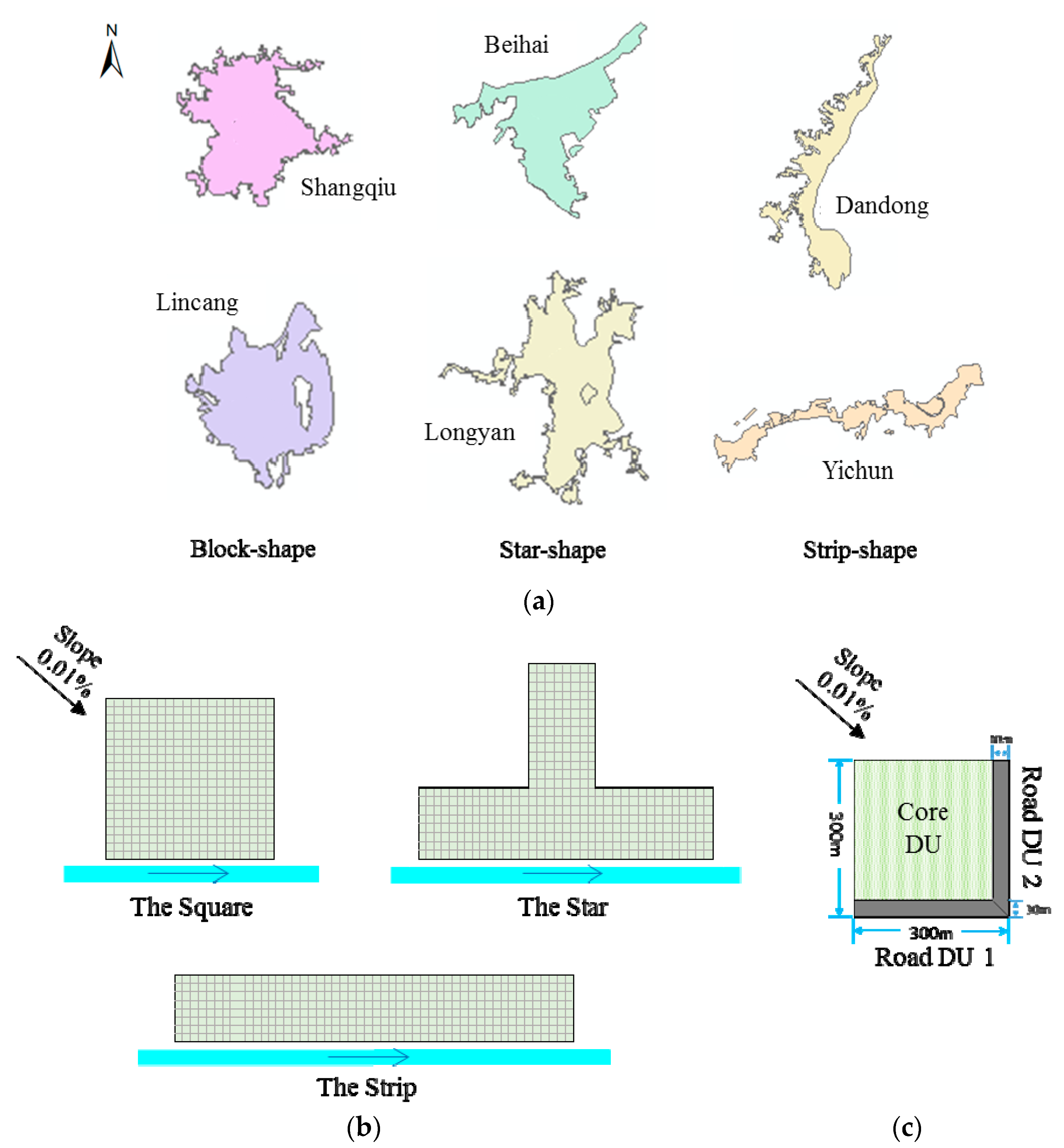
Figure 1. (a) Extracted shapes of built-up areas of six cities with three typical contour forms in 2015. (b) Virtual cities of three typical urban forms with the position and the flow direction of the receiving river. (c) The basic block and its three drainage units.
Water 11 00758 g001
Figure 2. Economic efficiency of the wastewater system (WS) and the rainwater system (RS) under three urban forms.
Water 11 00758 g002
Figure 3. Analysis of the pipe structure under three urban forms. (a) WS: average percentages of pipes with different diameters; (b) RS: Kernel smoothing function estimate of diameter multiplying depth of pipes.
Water 11 00758 g003
Figure 4. (a) Effectiveness of wastewater systems under three urban forms. (b) Effectiveness of rainwater systems under three urban forms.
Water 11 00758 g004
Figure 5. The average number of flooded nodes with weighted frequency of the RS under three urban forms.
Water 11 00758 g005
Figure 6. (a) Adaptability of wastewater systems under three urban forms. (b) Adaptability of rainwater systems under three urban forms.
Water 11 00758 g006
Figure 7. Ratios between quantity adaptability and number adaptability under rainfall events of each return period for the RS.
Water 11 00758 g007
Figure 8. Comprehensive evaluation results under three urban forms: (a) the wastewater systems; (b) the rainwater systems.
Water 11 00758 g008
Table 1. Attributes of drainage units in the virtual city. DU—drainage unit.
AttributesCore DURoad DU
Basic informationTypesThree One
Area7.29 ha0.855 ha
Number400800
Wastewater systemProduce wastewater?YesNo
Population900-
Where to discharge?Randomly choose any one of four surrounding roads-
Rainwater systemProduce rain water?YesYes
Runoff coefficient0.2, 0.6, and 0.70.9
Where to discharge?The road closest to the receiving water body Itself
Table 2. Basic settings and parameters of the model.
ItemsWastewater SystemRainwater System
Variables of samplingThe roads (pipes) includedThe layout of Core DUs
Design parametersTypical household wastewater discharge: 240 L/cap/day [45,50]Rain pattern: Chicago [51] 1
Return period: 2 years [45]
Rainfall intensity (of Beijing):
i = 10.5508 + 7.5646 lg R P ( t + 11.1907 ) 0.6867
Simulation parameters24 h, using a typical daily wastewater discharge curvePeak position coefficient: 0.35
Rainfall duration: 2 h
Rainfall events of different return periods
1 According to the code for design of outdoor wastewater engineering in China, the Chicago rain pattern is recommended when a local storm statistical model is not accessible [45].