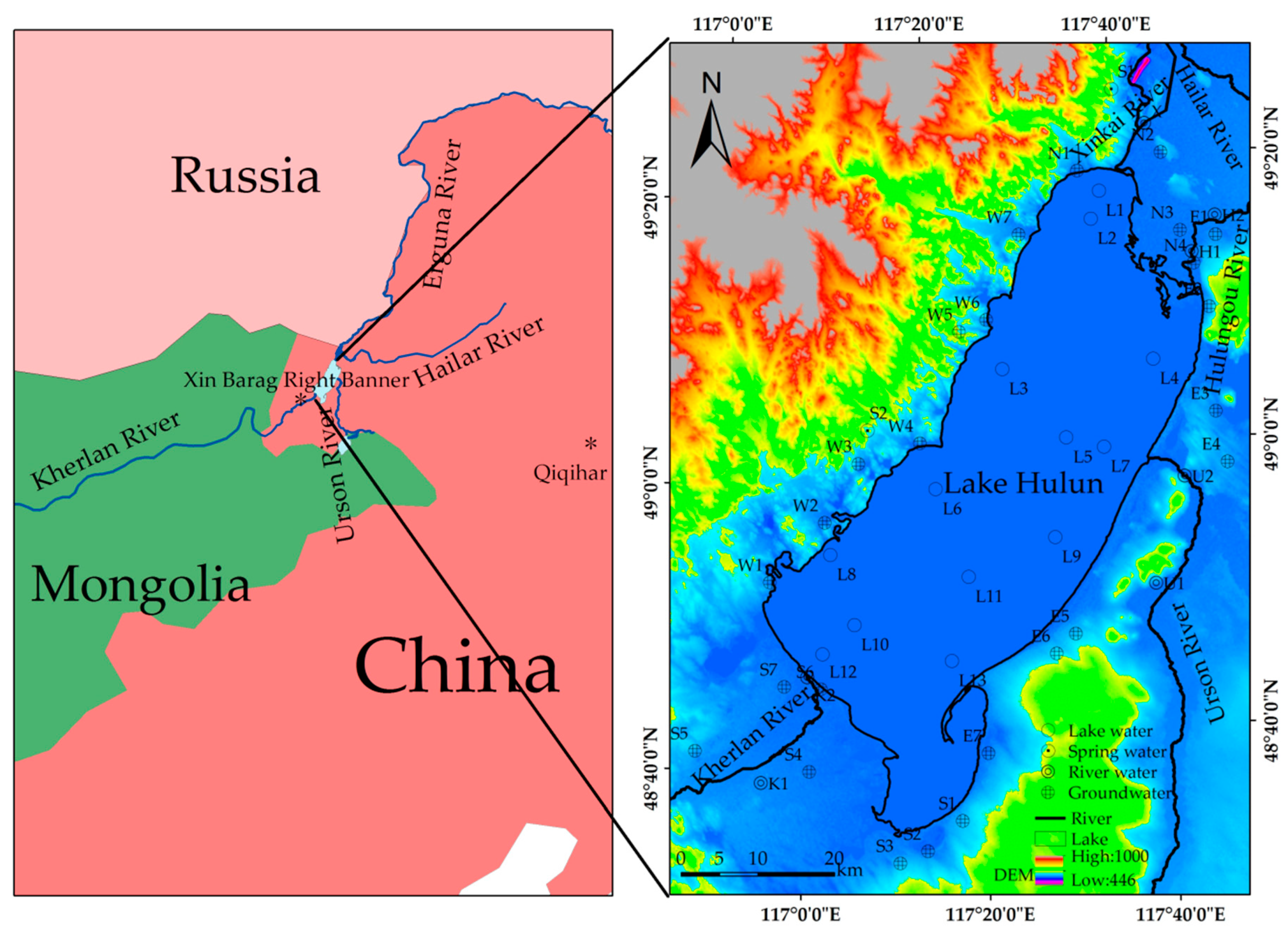
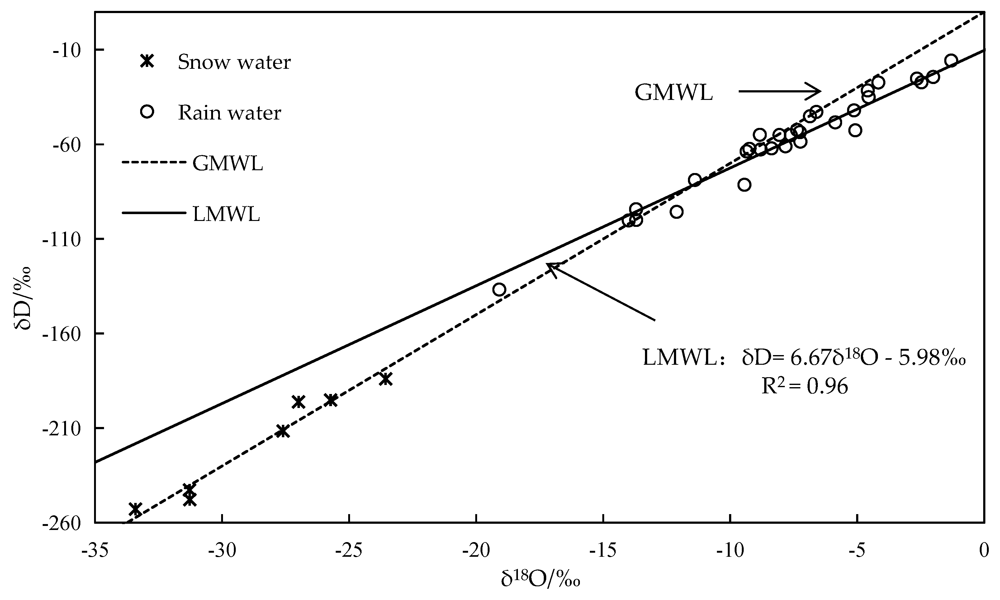
4.1. Local Meteoric Water Line in the Lake Hulun Area
Due to the different origins, types and degrees of isotopic fractionation in the precipitation, there are inevitably discrepancies in terms of the slopes and intercepts between the GMWL and LMWL for a specific region. It is therefore important to establish the LMWL before any investigation of the isotopic characteristics in a region is conducted. Based on an analysis of the hydrogen and oxygen isotopes in the local precipitation from June 2016 to September 2017, the snow water’s δD ranges from −253‰ to −184‰, the δ
18O value ranges from −33.4‰ to −23.6‰, the δD of the rainwater ranges from −137‰ to −16‰ and the δ
18O value ranges from −19.1‰ to −1.3‰. Based on this data, a weighted average of the hydrogen and oxygen isotope in rainwater can now be calculated and the LMWL in the Lake Hulun area determined (
Figure 2). The equation for LMWL in the study area is therefore defined as follows:
As
Figure 2 shows, the slope and intercept of the LMWL in the Lake Hulun area deviate somewhat from the global average levels. The slope of less than 8 indicates that the water vapor in the precipitation comes from a number of disparate origins that contain different ratios of these stable hydrogen and oxygen isotopes. This also suggests that some evaporation occurs during precipitation [
12]. It is interesting to note that samples from snow water are uniformly distributed along the GMWL. This can be explained by the fact that the cold winter climate in the Lake Hulun area promotes the gathering of heavy isotopes in the remaining water after the snow begins to form in the clouds. As the amount of fractionation is far less than that seen for precipitation evaporation, the isotope levels in snow water are lower than those in rainwater. Comparisons of the precipitation equations for northeast China (δD = 7.24 δ
18O + 1.96‰) [
13], Lake Dali (δD = 6.686 δ
18O − 8.3124‰) [
14], and Lake Wuliangsuhai (δD = 6.3 δ
18O − 5.6‰) [
15] show that the slopes and intercepts of the equations for the three main lakes in Inner Mongolia plateau are very similar. This suggests that the precipitation in all the lake areas in Inner Mongolia plateau will share broadly similar characteristics, with the minor differences observed indicating that in the area around each lake evaporation influences the precipitation slightly differently. The slope of the LMWL in the Lake Hulun area is less steep than that generally seen in northeast China, likely because the Greater Khingan Mountain Range blocks the moist air from the summer monsoon, which is the main source of precipitation in the Hulun Buir Grassland area, arriving from the Pacific. In addition, the lake water raises the temperature in the area, causing strong evaporation and resulting in a lack of δ
18O in the precipitation. The precipitation features on the eastern and western sides of Greater Khingan Mountain Range are thus significantly different. The marked differences in the climatic characteristics in the eastern and western parts of China also affect the composition of the isotopes in the atmospheric precipitation [
16], making it necessary to gather data to establish the local LMWL in the Lake Hulun area.
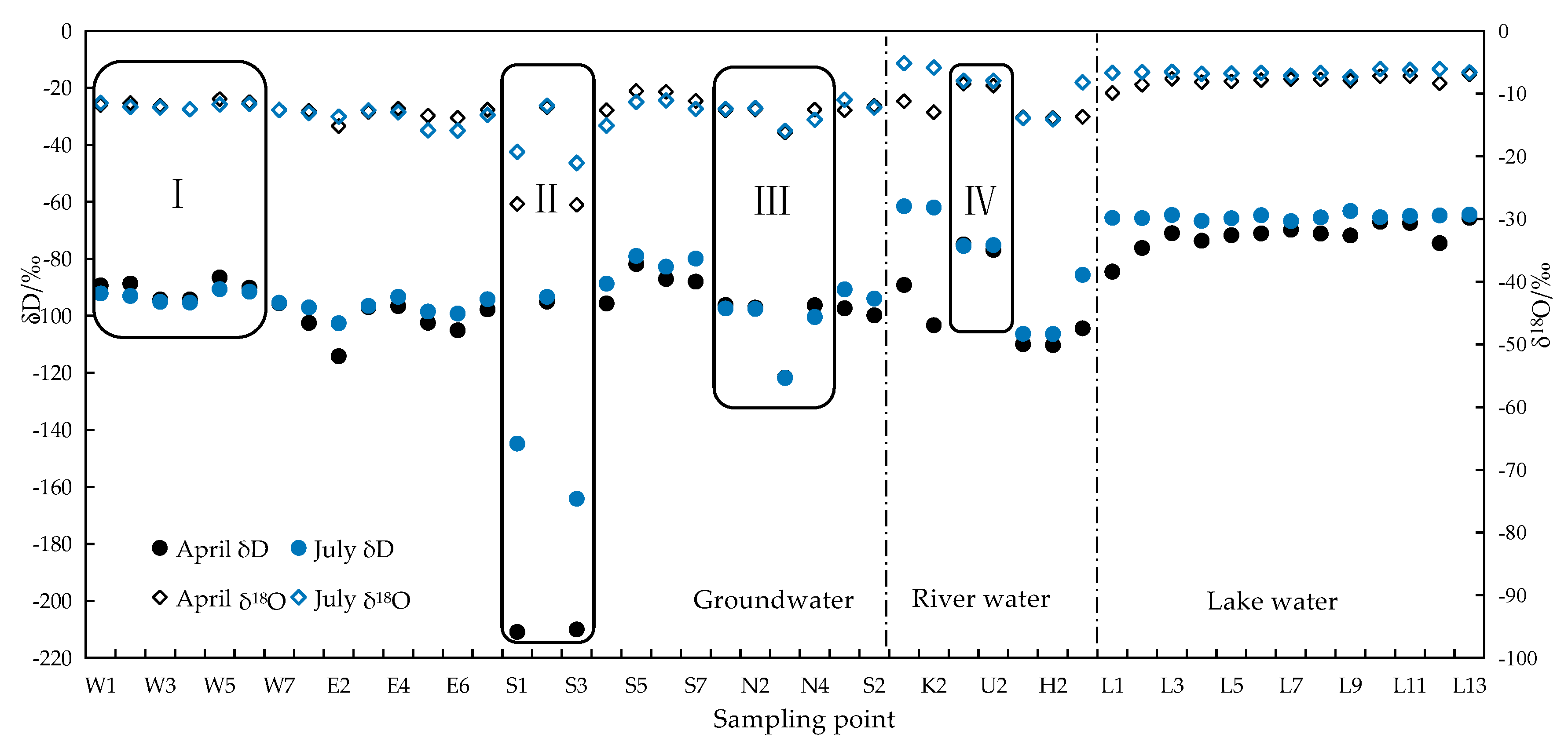
4.2. Changes in the Water Isotopes in the Lake Hulun Basin
The results of the stable isotope analysis are shown in
Table 1 and indicate that the δD values recorded in the lake water ranged from −84.5‰ to −63.2‰ and the δ
18O values ranged from −9.9‰ to −6.1‰, while for spring water these ranged from −103.3‰ to −89.1‰ and from −12.9‰ to −10.9‰, respectively. In the river water, the δD values ranged from −110‰ to −62‰ and the δ
18O values from −13.9‰ to −5.2‰; the δD values in the well water ranged from −211‰ to −100‰ and the δ
18O values ranged from −27.6‰ to −8.4‰.
Table 1 shows that the evaporation intensity for each type of water during the frozen period is lower than that during the non-frozen period. As the variation of hydrogen and oxygen isotopes in water bodies is influenced by evaporative fractionation [
17]. Among them, the δD values and the δ
18O values of lake water passed the Rank sum test of
p < 0.01 (n = 13), and the groundwater (including two springs water) passed the Student’s t-test of
p < 0.01 (n = 27). The Student’s
t-test of the δD values and the δ
18O values of river water were
p = 0.252 and
p = 0.249 (n = 7), respectively. This was attributed to the small number of river water samples which came from four different. In April, when the lake is frozen, the temperature falls below zero degree Celsius in the Lake Hulun Basin and the surface water is covered with ice, which greatly reduces the water evaporation and interferes with the normal evaporative fractionation of the water body. In contrast, in July the water evaporates under the influence of the relatively high temperatures in the region, resulting in a significantly higher accumulation of heavy isotopes in the lake, spring and river water than in the groundwater.
The variations in the levels of the hydrogen and oxygen isotopes in the lake, river and groundwater during frozen and non-frozen periods (
Figure 3) indicate that the accumulation of these heavier isotopes in the lake and river water is higher in the non-frozen period than when the lake is frozen. The degree of this fractionation is significant and stable and conforms to the thermodynamic isotopic effect [
18,
19]. It is interesting to note that the levels of the hydrogen and oxygen isotopes were lower in July than in April in the groundwater collected from wells along the western side of the lake that lie along the fault zone to the west of the lake basin (
Figure 3I). A tentative explanation for this phenomenon is that it arises due to the recharge from lake water to groundwater along the western lakeshore, although this can only be confirmed by further research. In addition, intense evaporative fractionation of the hydrogen and oxygen isotopes was observed in two wells S1 and S3, both of which are located along the southeastern shore of the lake. The δD levels in these two wells during the frozen period were found to be −211‰ and −210‰, respectively, and the δ
18O levels in the wells were −27.6‰ and −27.8‰, respectively, which are close to the levels of hydrogen and oxygen isotopes found in snow (
Figure 3II). Interestingly, during the non-frozen period, the δD levels measured in the two wells were −145‰ and −164‰, respectively, and the δ
18O levels were −19.3‰ and −21.1‰, respectively, slightly lower than the levels of these isotopes in the local rainwater. This suggests that the main source of groundwater in this area is the recharge from the rain. The melting and infiltration of snow and the exchange intensity of groundwater are relatively weak. Field research in this part of the study area, which is located to the southeast of the lake area, found the soil to consist of Quaternary Holocene Aeolian dune rock, sand hills and ridges with coarse-fine and silt grains. The wells are generally 1–2 m below the surface in this area, with no nearby rivers or springs. This observation further supports our conclusion that the primary recharge source for shallow groundwater is atmospheric precipitation. The temporal variations in the isotope levels in the four wells in the third box (N1–N4; groundwater) and in the two wells close to the Urson River (U1 and U2; river water) are relatively small. The evaporative fractionation is weak, and is not seasonal, which indicates that both the groundwater to the north of Lake Hulun and the Urson River itself have their own stable recharge sources.
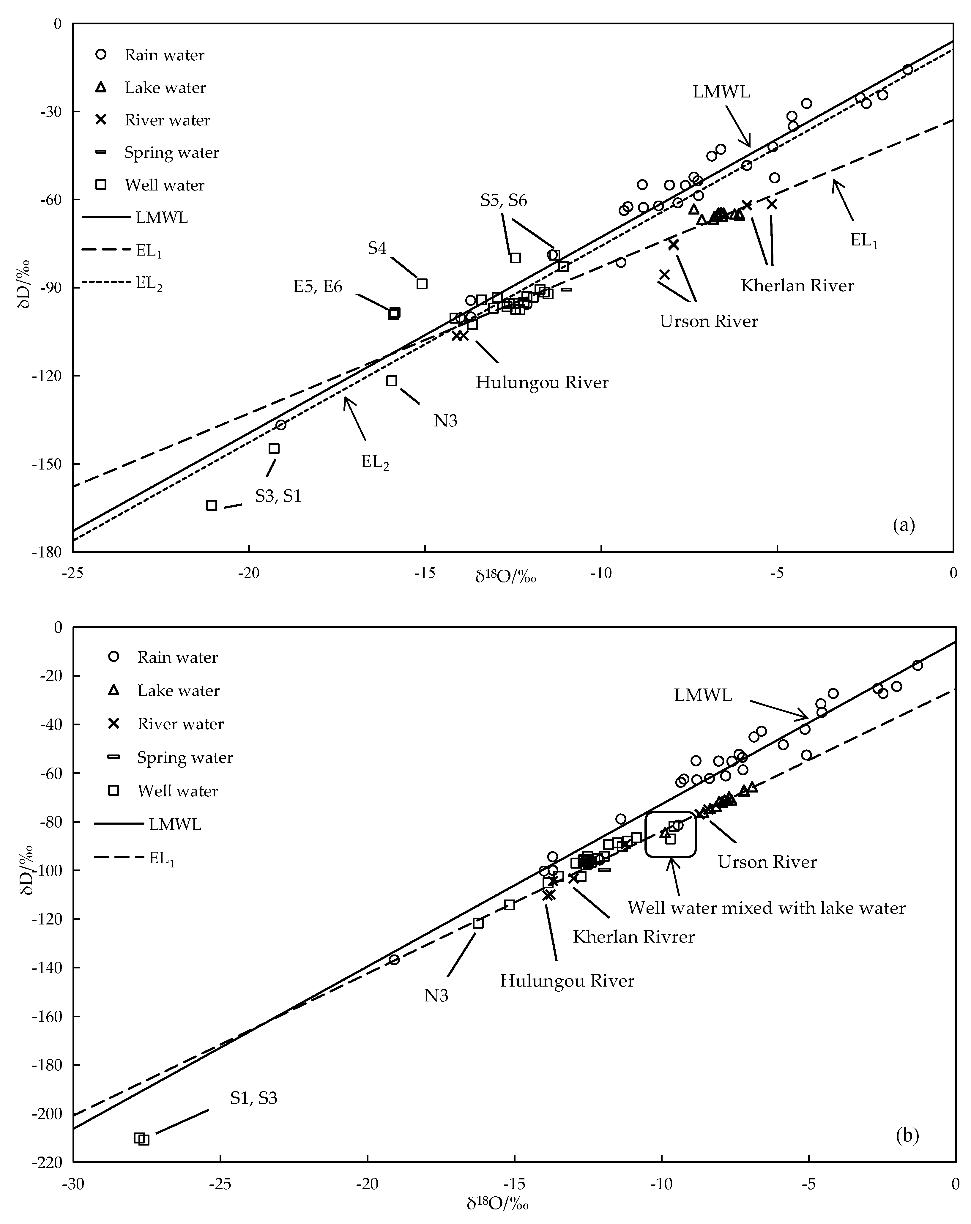
4.3. Analysis of the Isotopes in Water Bodies in the Lake Hulun Area
The relationships between the hydrogen and oxygen isotopes in precipitation, water, river, well and spring in the Lake Hulun area during the non-frozen period are shown in
Figure 4a. Although the values of δD and δ
18O in the lake and river water both fall below the LMWL, the values of δD and δ
18O for the lake water are more stable and intense than that of those for the river water. This suggests that the wide lake surface of Lake Hulun is subject to strong evaporation, leading to excessive fractionation of the isotopes. It accords with the fact that Lake Hulun is located in an arid/ semi-arid area where evaporation is greater than precipitation. The following EL
1 equation for the evaporation trend line for the Lake Hulun area is thus obtained through a regression analysis of the hydrogen and oxygen isotope levels in the lake and its inflowing rivers.
The evaporation line EL
1 for the lake and its surrounding rivers falls below the LWML as the isotope levels increase. This phenomenon often occurs in a dry climate or closed basin. The fact that the values of water samples fall at different positions on the evaporation trend line indicates the different degrees of evaporation experienced by each of the different water bodies in the study area [
20]. Compared with the slopes of 4.9678 [
21] obtained for the Lake Daihai region and 4.66 [
22] for the area around Lake Wuliangsuhai in the Inner Mongolia plateau, the degree of evaporation in the Lake Hulun area is closer to that for Lake Daihai than Lake Wuliangsuhai. The isotope levels at the intersection between the evaporation line and the global meteoric water line determine the isotopic composition of the initial recharge source of the lake [
23,
24]. In this case, the δD and δ
18O values at the intersection of the weighted averages of the initial precipitation that can effectively recharge Lake Hulun are approximately −100‰ and −15.9‰, indicating a combination of precipitation, groundwater and river water. Field research also found that the elevation of the groundwater in the study area is generally higher than that of the lake water level, which is the hydraulic condition required for recharge from groundwater to the lake. The data presented in
Table 1 also show that the average Cl
− concentration in the lake water is lower in April than it is in July. With the advent of the rainy season, the volume of the runoff carried by the major inflowing rivers increases considerably, but given that the mean concentration of Cl
− in these rivers is relatively low, at only around 11−15 mg/L, this suggests that the significant increase in the Cl
− concentration in the lake water is actually due to recharge by groundwater. This provides further evidence that groundwater is the main source of recharge for Lake Hulun, supplemented by direct recharge from the rivers and precipitation. The following EL
2 equation for the evaporation trend line of the groundwater is thus obtained through a regression analysis of the hydrogen and oxygen isotopes in the groundwater in the Lake Hulun area:
As
Figure 4a shows, when the lake is frozen the trend lines for EL
2 and LWML are close to each other and both the groundwater and precipitation samples are distributed in close proximity to these two lines. This further corroborates our conclusion that the main recharge source of groundwater is precipitation, and the evaporative fractionation of the groundwater is stronger than that for precipitation. Meanwhile, it was found that the water samples of E5, E6, S4, S5 and S6, are all located above LWML, a significant deviation. Similar to the case of the Heihe River, which originates from the Qilian Mountains [
25]. This phenomenon is likely due to a change in the isotope balance, which dilutes the δ
18O thus causing the δ
18O levels measured in the samples to drift downwards.
As to whether the precipitation can be effectively recharged into the groundwater through the aeration zone, it is first necessary to study the transport of rainwater in the soil. Many research methods focus on indoor rainfall infiltration experiments to test soil profiles at different depths in the study area [
26,
27]. However, since the area covered in the present study is large, and the local geology complicated due to the many different types of geological landforms surrounding the lake, indoor precipitation infiltration experiments cannot be effectively applied in Lake Hulun area. Our research team from Inner Mongolia Agricultural University has conducted longitudinal studies in the Lake Hulun area to monitor the groundwater levels before and after the rainy season (mainly from June to August) around the lake for four consecutive years. The results of the monitoring, which are shown in
Table 2, indicate that the groundwater level around Lake Hulun after the rainy season is generally higher than before the rainy season, confirming that precipitation does indeed recharge the groundwater. According to the regional hydrogeological data, bedrock fissure water is widely distributed to the west of Lake Hulun, which is mainly composed of Mesozoic volcano rocks and Hercynian and Yanshan-period granite, with pore water in the loose rock formed during the Quaternary period being distributed on the top. On the eastern side of the lake, fissure phreatic water in volcanic rocks is widely distributed and is mainly found in the small basins between hills, at weathering fractures, and in vein-shaped structural fissures of volcanic rocks in the Upper Khingan Range and granite formed during the early Yanshan Period. Pore-water in a strip of Holocene lacustrine sand is distributed along the Lake Hulun Beach area. Hence, even in parts of the Lake Hulun area where the annual evaporation is up to 7 times the precipitation that falls, precipitation infiltration can achieve the maximum possible soil water holding capacity and thus recharge the shallow groundwater through infiltration into the saturated zone. These findings are in sharp contrast to the situation in Lakes Wuliangsuhai and Daihai, where precipitation in the surrounding area cannot effectively recharge the groundwater [
21,
22].
The analysis of the isotope levels in each of the different water bodies in the Lake Hulun area during the frozen period, shown in
Figure 4b, reveals that the water samples are evenly distributed along the evaporation line. Some samples from wells are mixed with those from the lake, leading to homogenization of the mixed isotopes. A comparison with
Figure 4a reveals that there are traces of isotopes in snow water at two sites, N1 and N3, during the summer. Among the three major inflowing rivers, the isotopes in the Hulungou River and the Urson River remain stable across the seasons, while those in the Kherlon River demonstrate significant changes. The values for the hydrogen and oxygen isotopes in July are higher in the Kherlon River than in the Lake Hulun, which indicates that in the summer the Kherlon River is strongly influenced by evaporative fractionation. This may be explained by the slow flow velocity of the river, its wide riverbed and even the“urban heat island effect” to some extent since the Kherlon River flows through Xin Barag Right Banner into the lake. The Hulungou River, which flows into Lake Hulun from the north, has significantly lower levels of the hydrogen and oxygen isotopes than the surrounding groundwater and the relatively lower levels seen in lake water near the river mouth are thus likely due to its recharge into the lake water diluting the effect of the nearby groundwater. The reverse is the case for the Urson River, which has accumulated more heavy hydrogen and oxygen isotope and hence has higher levels of both isotopes than either the surrounding groundwater or the lake water. The Urson River flows into Lake Hulun to the right of high plains located along the Cuogang Uplift Belt, where rocks are exposed to open air and joints and fractures in the strata are formed, which facilitates the direct infiltration of atmospheric precipitation. Therefore, it can be surmised that the reason for the relatively dense accumulation and consistently high levels of hydrogen and oxygen isotopes in the Urson River are due to the reception of recharge from groundwater from the high plains that has travelled through rock fractures along the river’s left bank.
The values found for the hydrogen and oxygen isotopes in well water at the N3 site, shown in the third box in
Figure 3, are quite consistent. Comparing
Figure 4a with
Figure 4b, the water samples from N3 are below LWML, deviating significantly from the evaporation line for groundwater and surface water, indicating that the water samples collected at this site originate from a different source or combination of sources than the other samples. The δD and δ
18O of the well water in April and July are −121.61‰ and −16.24‰, and −121.75‰ and −15.95‰, respectively. The levels of both isotopes are lower than those in the nearby Hulungou River, which suggests that the river is not the main recharge source of the groundwater in this area. Field research found the pH value of the groundwater near site N3 to be weakly alkaline, with the only exception being the well water sample collected at the site itself, which was below 7. Interviews with local herdsmen revealed that the amount of fluorine ions in the well water exceeds the amount permitted in drinking water and that the alkalinity or acidity and degree of mineralization in two wells that are only a few hundred meters apart can be dramatically different. The hydrogeological map shows that this area is located in the transitional fracture zone between Mount Huoerpo, Mount Huoerwula and the Zhalainuoer depression belt northeast of Lake Hulun. This fracture zone stretches across the entire area. The Derbugan deep fault also crosses the area along the eastern margin of Lake Hulun. The concentration of Cl
− in Well N3 was 72 mg/L in April and 134.7 mg/L in July, which suggests that the lake cannot be recharged by either infiltration or fracture. The presence of fracture recharge from water bodies containing lower levels of the hydrogen and oxygen isotopes cannot be ruled out, however, and this remains to be tested in future research.
4.4. Distribution Features and Tracer Analysis of Cl− in Water Bodies in the Hulun Lake Area
In terms of tracer analysis, the most important advantage of Cl
− is its conservativeness after the atmospheric sediment into the soil layer. Therefore, the conservativeness property of Cl
− in soil water and groundwater is better than that of tritium in the water bodies during convection, dispersion and diffusion. Some amount of tritium will be lost in its evaporative and diffusive gaseous form, while Cl
− is completely nonvolatile under normal conditions. Therefore, Cl
− will stay in the aqueous water without entering the atmosphere and will not be removed by normal geochemical processes. Therefore, Cl
− serves as an excellent tracer to study the recharge of groundwater [
28]. The analysis of the spatial distribution of Cl
− in water bodies in the basin can help further understand the recharge and discharge relationships between surface water and groundwater in the basin.
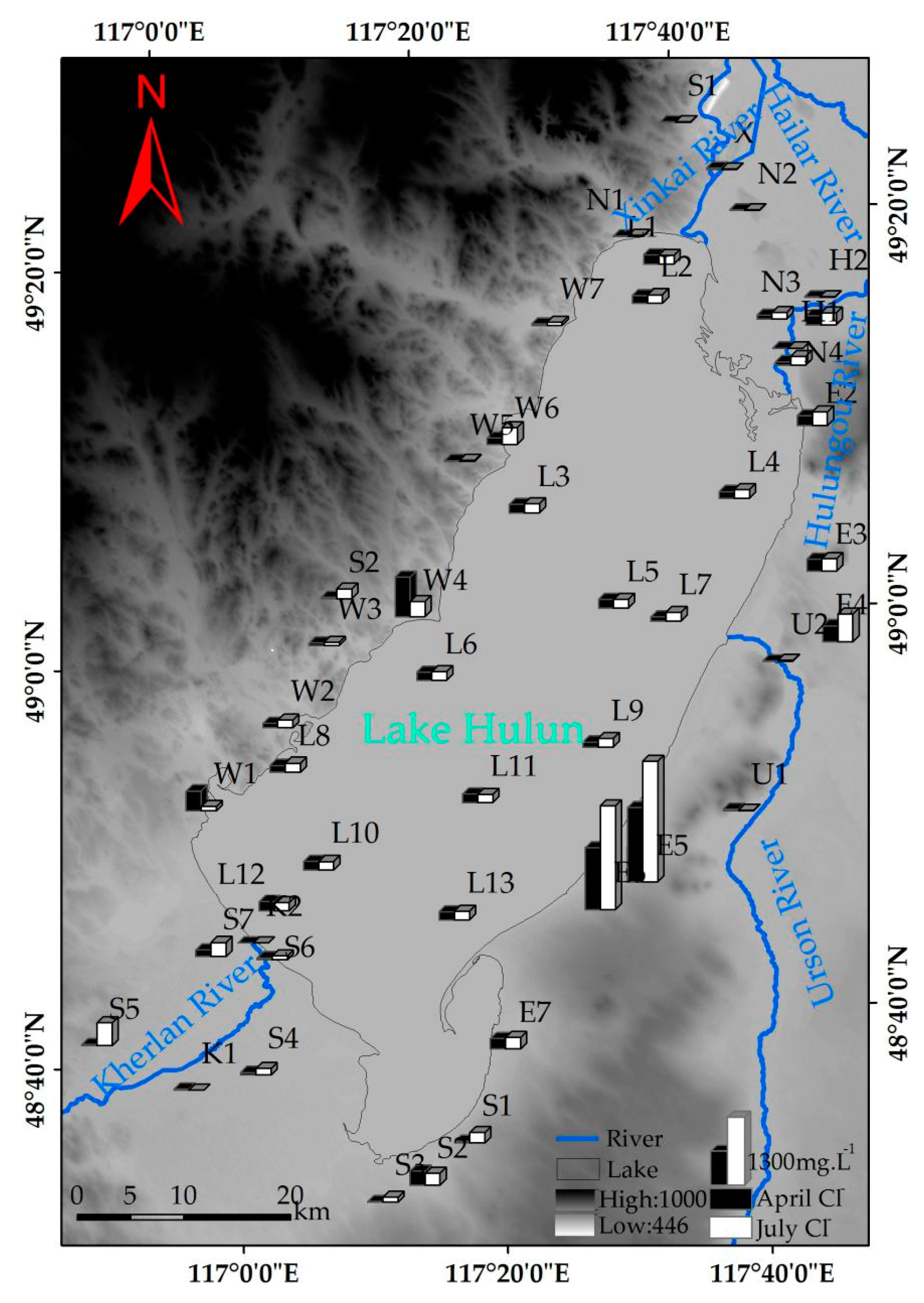
As shown in
Figure 5, the Cl
− concentration in the Hulun Lake lake Hulun Lake in different periods of remained relatively constant. The Cl
− concentration in the inflowing rivers into the lake during the frozen and non-frozen periods is far less than that in the lake and surrounding groundwater. In addition, the concentrations in the surrounding wells near the lake vary greatly and change significantly in different periods. In the water samples from Well E5 and E6 in the right of the lake basin, concentrations of Cl
− were significantly higher than those from other wells. It can be explained by the influence of the landform, i.e., the Cuogang uplift zone. This is consistent with the recharge relationship from groundwater to Urson River in the above analysis of hydrogen and oxygen isotope. Meanwhile, the area is mainly composed of the high plains with flat terrain, strong evaporation, and weak exchange between groundwater, which accelerates mineralization and concentration of Cl
−. In the water samples from Well E3 and E4 in the north of the lake where Urson River flows into the lake, the concentration of Cl
− in groundwater during the frozen and non-frozen periods is significantly higher than that in water. The hydrogen and oxygen isotope in the two wells remain constant across the seasons. Besides, the two newly formed lakes caused by the crevasse due to the rising water level in the Hulun Lake are located here [
29]. It indicates that this area is lower than the Hulun Lake. Regional hydrogeological data and field research shows that Cuogang uplift belt has been developed in the east of Hulun Lake, and the trans-tensional fault is well developed on the belt. This suggests that the effect of tensile stress lasts rather long, which subsequently cuts Mesozoic tectonic layers into pieces. The tensional fault between Huoerpo Mountain and Huoerwula Mountain is formed in the direction of N50° and west in this area. The southern slope of Huoerpo Mountain is steep, while Huoerwula Mountain is isolated with a steep slope on the northern and eastern sides, demonstrating the characteristics of tensional fault and connecting the Hulun Lake with newly formed lakes. According to the indications of hydrogen and oxygen isotope and Cl
−, in addition to the outflow from the Hulun Lake into newly formed lakes, water in the Hulun Lake can also recharge the groundwater in this area through the underground fault.
The concentration of Cl
− in Wells W1 and W4 on the western side of the lake basin were significantly higher when the lake was frozen than when it was not, with Cl
− concentrations of 421 mg/L and 854 mg/L, respectively, in April, and 88 mg/L and 325 mg/L in July, markedly different from the levels measured in other wells along the western side. This suggests that during the frozen season these two wells receive recharges from water bodies with higher Cl
− concentrations compared to those tapped in the non-frozen period. According to the data shown in
Figure 3, the amounts of the hydrogen and oxygen isotopes present in the groundwater during the frozen period are abnormally high compared to those during the non-frozen period.
Figure 4b includes data points indicating that some well water becomes mixed with lake water during the frozen period; the field researchers noted that these two wells are both less than 500 m away from the lake shore. Wells W1 and W4 are 19 m and 60 m deep, respectively. Being so close to the lake, the elevation of the water level at these locations is approximately the same as that of the lake water level, leading to poor water quality and salinity exceeding the level permitted by the water quality criteria for drinking water; the water in Well W4 is yellow and turbid. The Xishan fault is located along the western lakeshore in the lake basin. The specific geographic location and climatic characteristics of Lake Hulun mean that every year the winter starts from at the end of October, when the lake starts to freeze and ends in early May when the lake ice starts to melt. The rate of evaporation reaches its maximum in May and June, with monthly evaporation of up to 270–370 mm, leading to the volume of lake water decreasing and a noticeable drop in the lake’s water level. In July and August, the amount of precipitation in the area reaches its peak, and this precipitation recharges the lake via infiltration, increasing the amount of runoff in the inflowing rivers and a rise in the lake’s water level. From October onwards the temperature in the Lake Hulun Basin drops sharply and lake ice starts to form. As the winter progresses the lake ice gradually expands downward, further elevating the lake surface and putting pressure on the lakebed. Although the 0.5 m layer of sludge at the bottom of the lake is very effective at sealing leaks when the lake is not frozen, after a cycle in which the water level of the lake falls and rises again lake water is discharged through the faults on both sides of the lake basin during the frozen period.
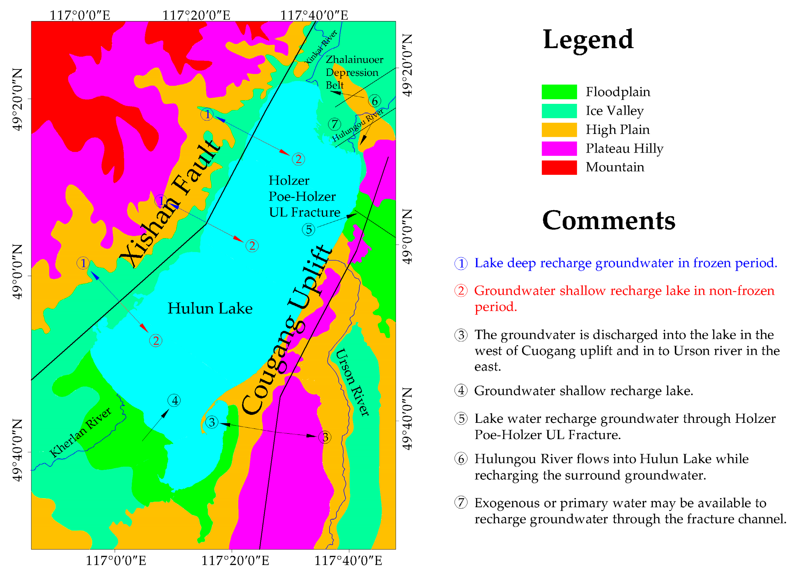
4.5. The Recharge and Discharge Relationship between the Lake and Groundwater in Lake Hulun
The local climate, geology, geomorphology and geological structure determine the hydrogeological conditions in the study area. Lake Hulun is located within the third Neocathaysian subsidence belt in the western Hailar basin. The geological structure formed by in-situ stress is highly complex in terms of its nature, order and distribution; the situation is further complicated by the fact that much of it is covered and hidden underground by the Cenozoic strata. The emergence of new satellite lakes formed by two crevasses suggests that as an occlusive tectonic lake, Lake Hulun has no other discharge outlets than those provided by the fault zones that lie along both sides of the lake and that the velocity and volume of the discharge into these fault zones are both limited. In terms of the relationship between geological structure and hydrogeology, it seems likely that the main reason why the occlusive Lake Hulun, which is located in a basin and has no effluent water outlet, can survive salinization is that the lake water recharges the underground water along both sides of the tensional fracture.
Based on the field research and the prior research in this area reported in the literature, and taking into account the evolutionary characteristics of the hydrogen and oxygen isotopes and the Cl
− levels in the lake and the nearby rivers and springs measured for two typical periods, a diagram depicting the recharge and discharge relationship of the lake and groundwater in Lake Hulun can now be constructed (
Figure 6). The directions of the arrows in the figure indicate the recharge and discharge flows in or out of the lake and/or groundwater: ①⑤ indicate the recharge from the lake water into the groundwater through the deep fracture on both sides of the lake; ②④ represents the recharge from groundwater flowing into the lake by means of shallow runoffs; ③ indicates the recharge passing through precipitation fissures on the high plains due to the Cuogang Uplift Belt into the groundwater and eventually into lake on the western side, and into groundwater and eventually the Urson River on the eastern side; ⑥ shows how the runoff from the Hulungou River recharges the lake as well as the groundwater; and ⑦ indicates the possible recharge from exogenous deep water or initial water into the groundwater in this area through the fault channels evidenced by the far lower Cl
− concentrations and levels of hydrogen and oxygen isotopes measured in Well B3, which is located at the intersection of the Zhalainuoer Depression Belt and the fracture belt.


