Numerical Study of Remote Sensed Dredging Impacts on the Suspended Sediment Transport in China’s Largest Freshwater Lake


Abstract
:1. Introduction
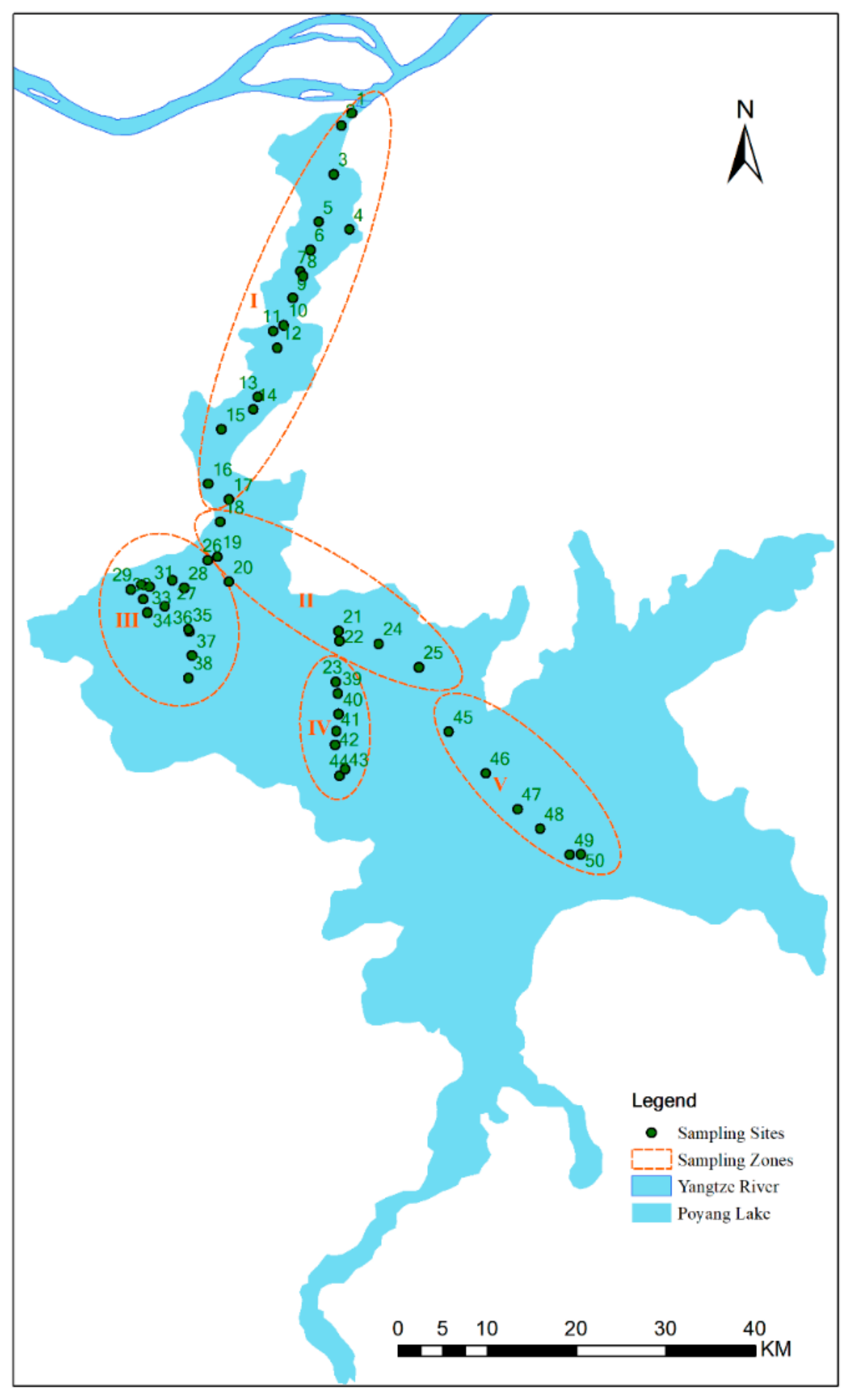
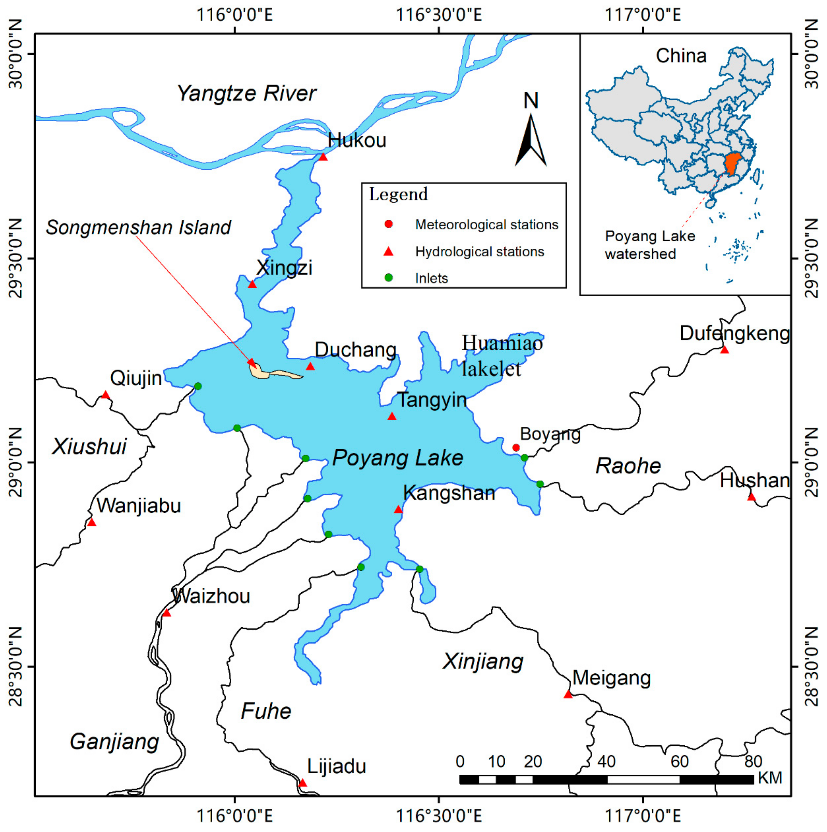
2. Study Area and Data
3. Methods
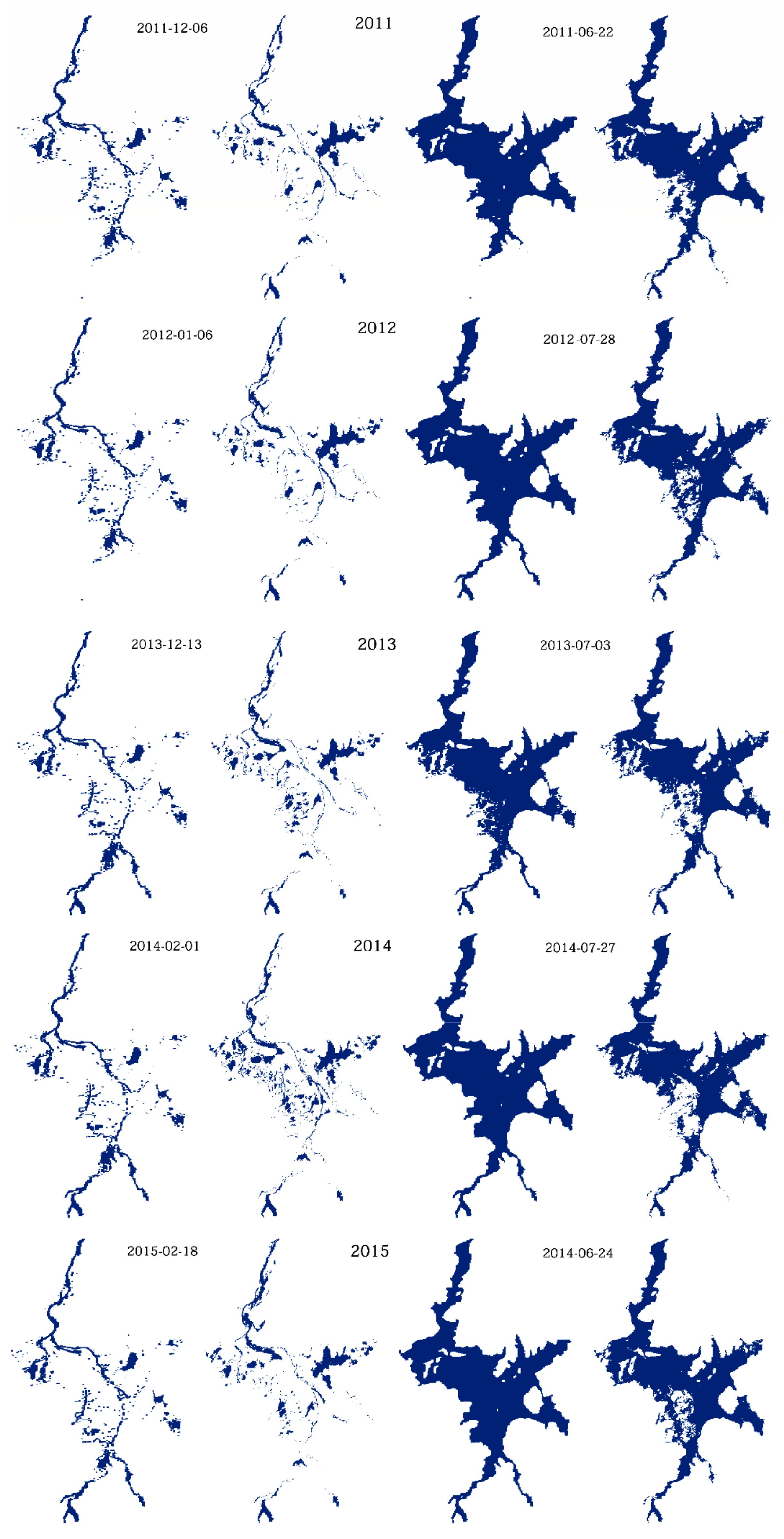
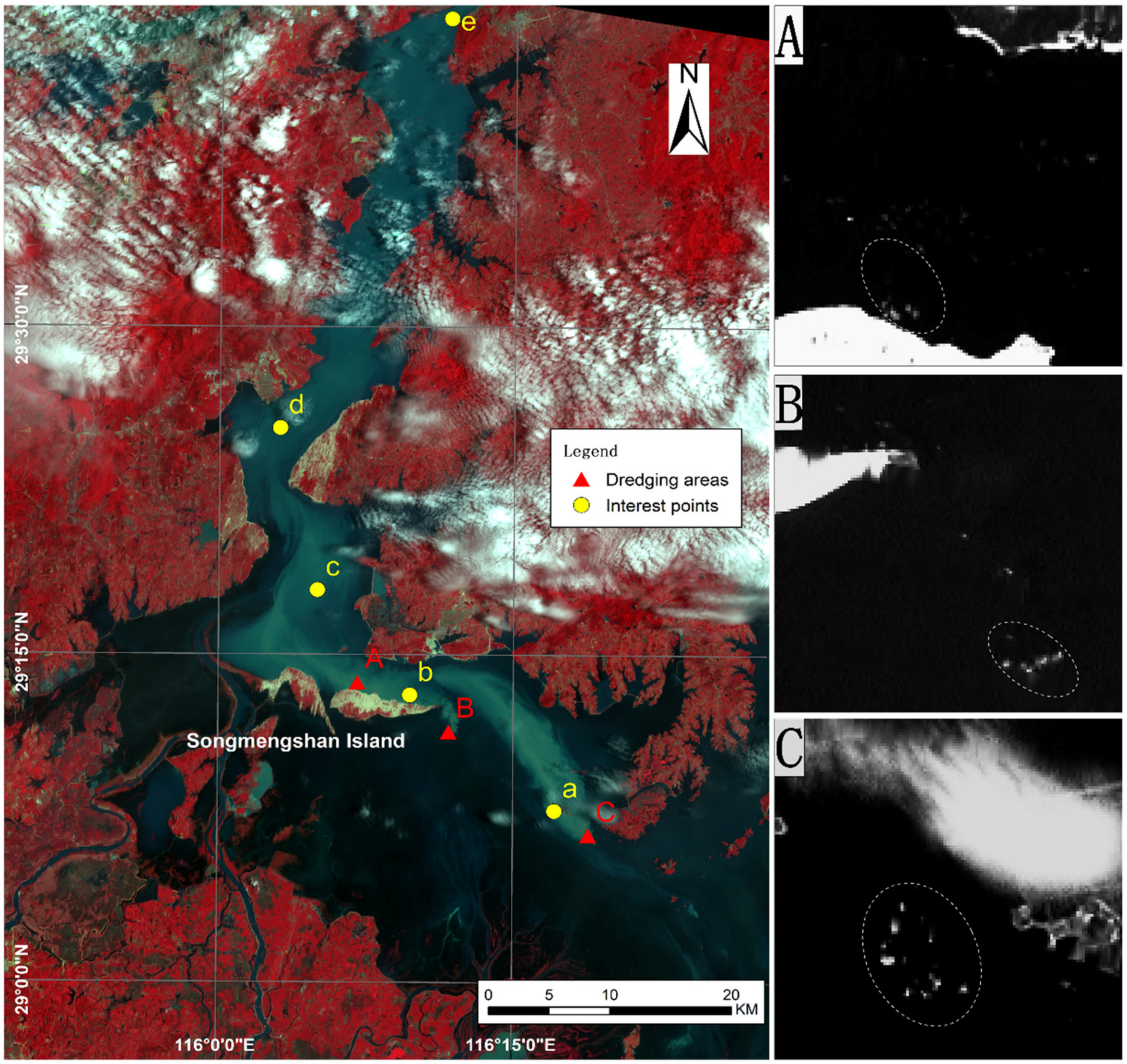
3.1. Remote Sensing Image Processes
3.2. Hydrodynamic-Sediment Transport Model Setup for Poyang Lake
4. Results and Discussion
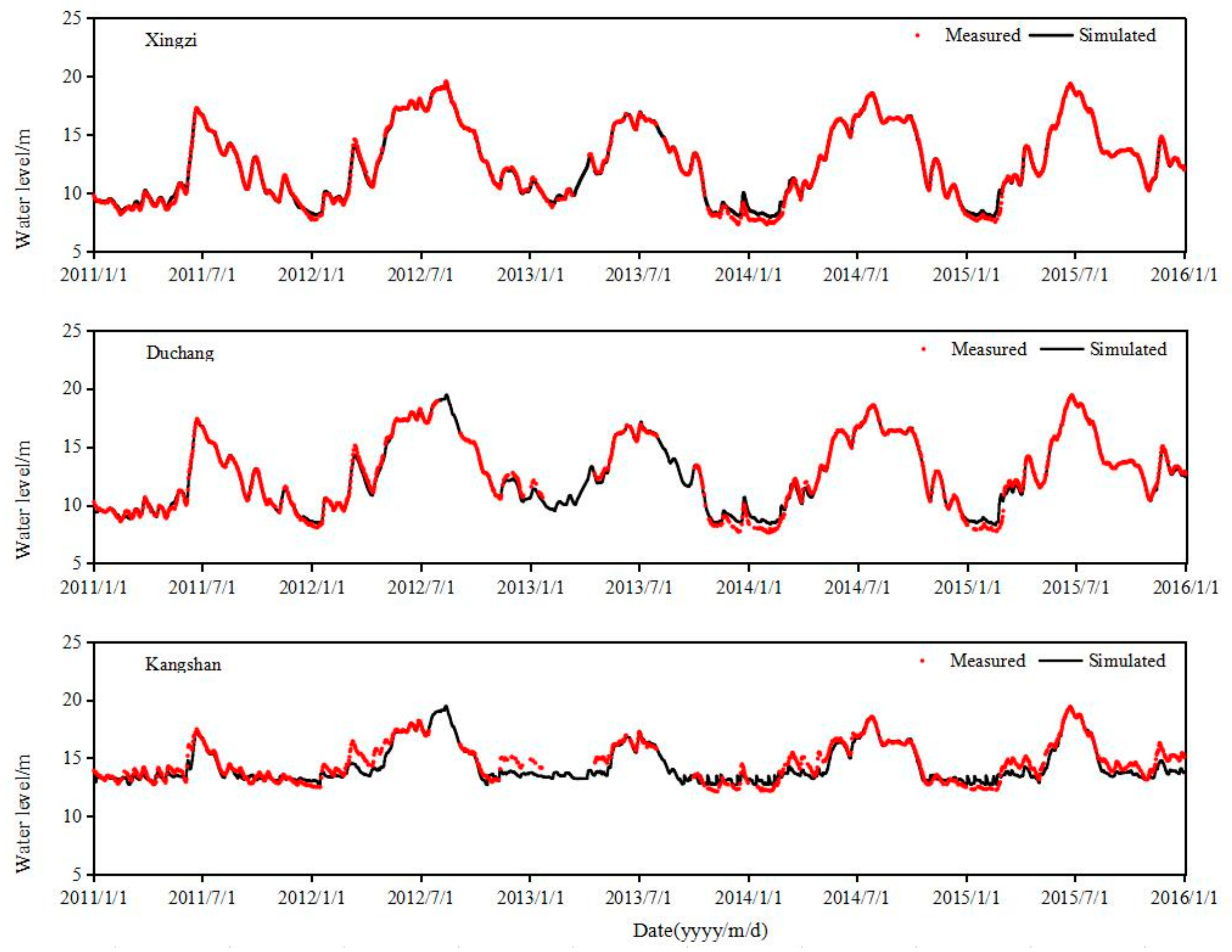
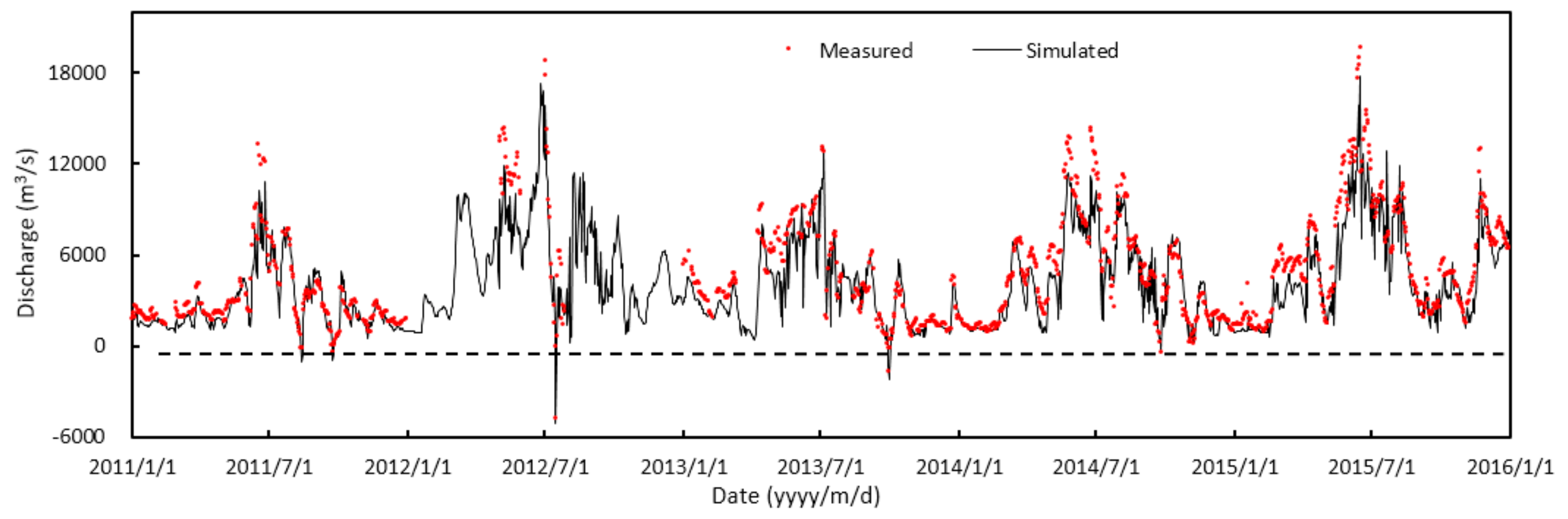
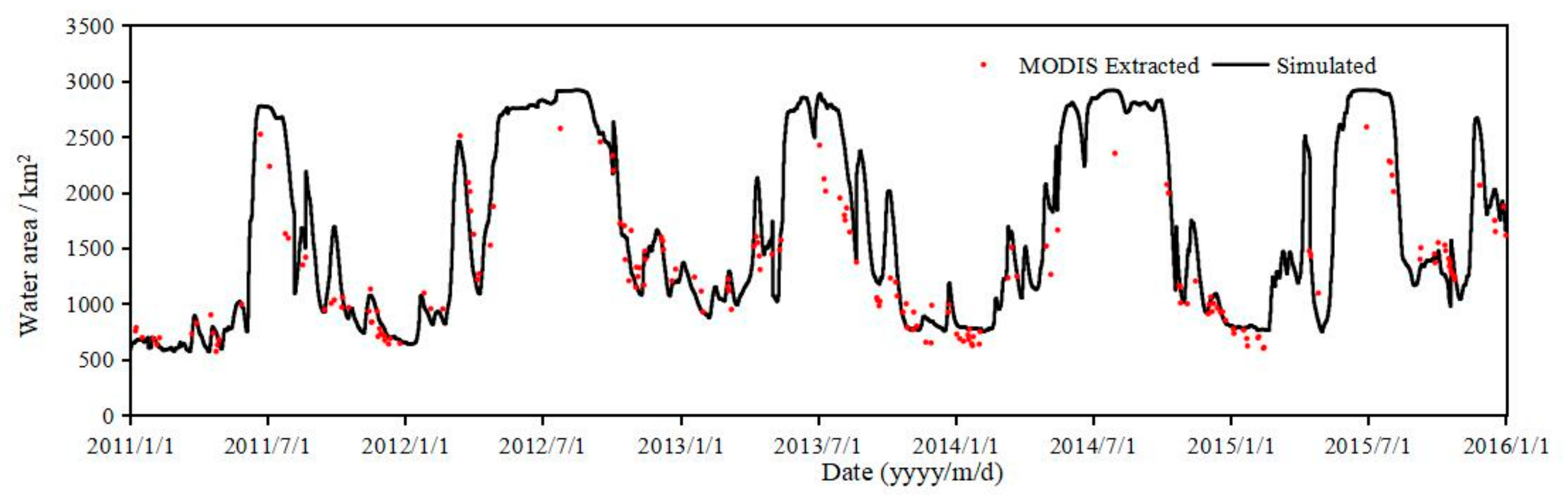
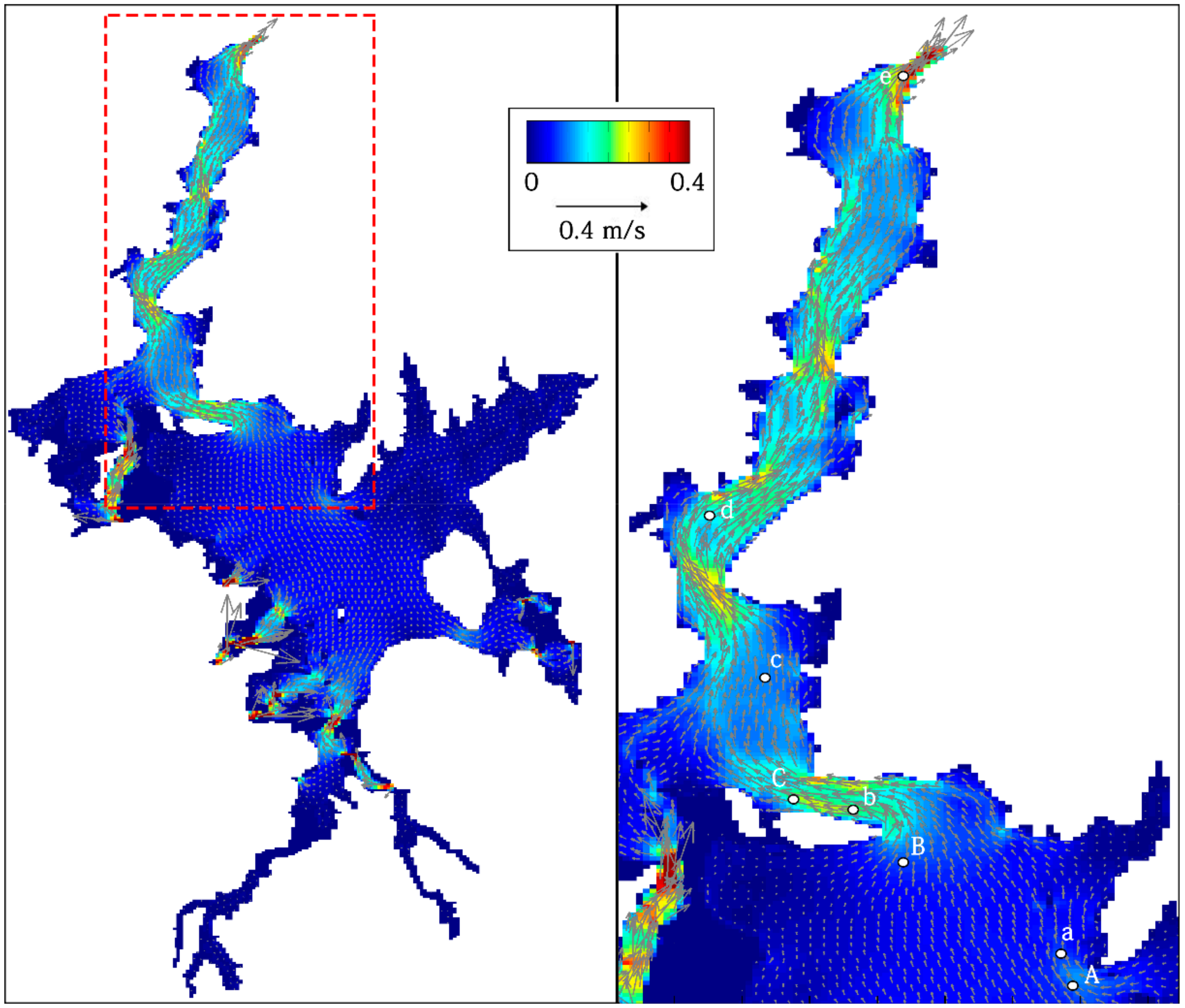
4.1. Hydrodynamic Model Validation
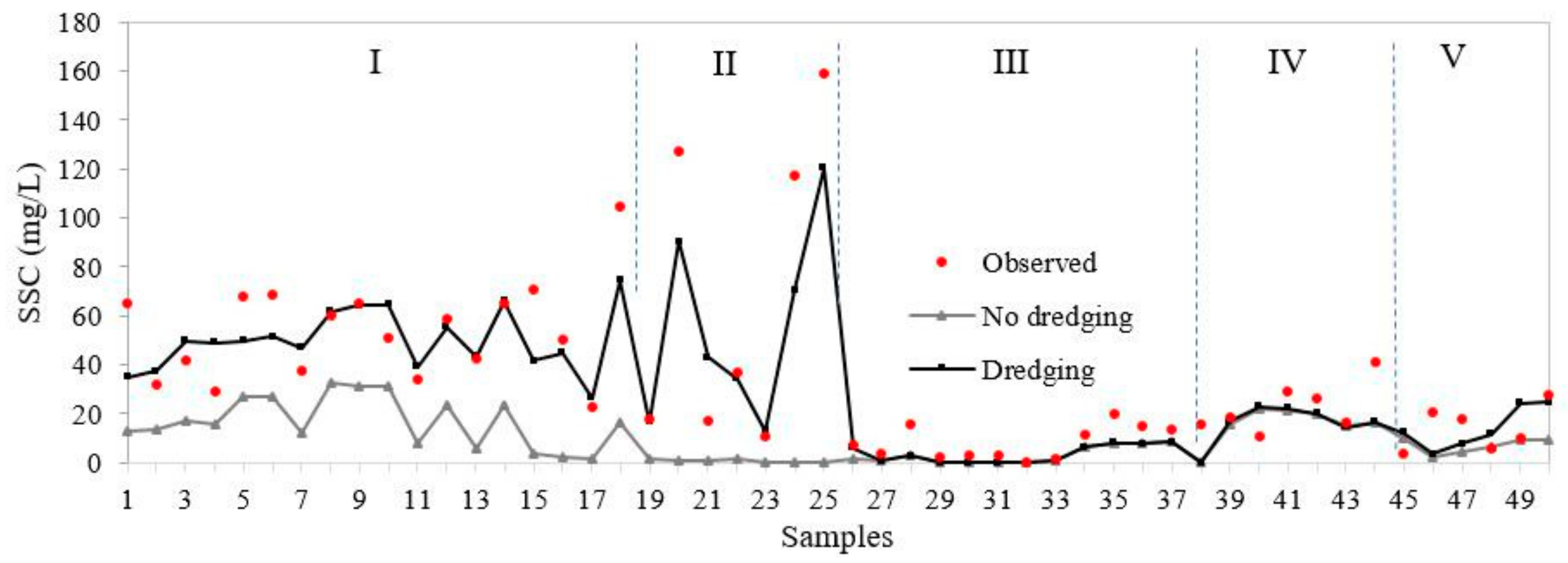
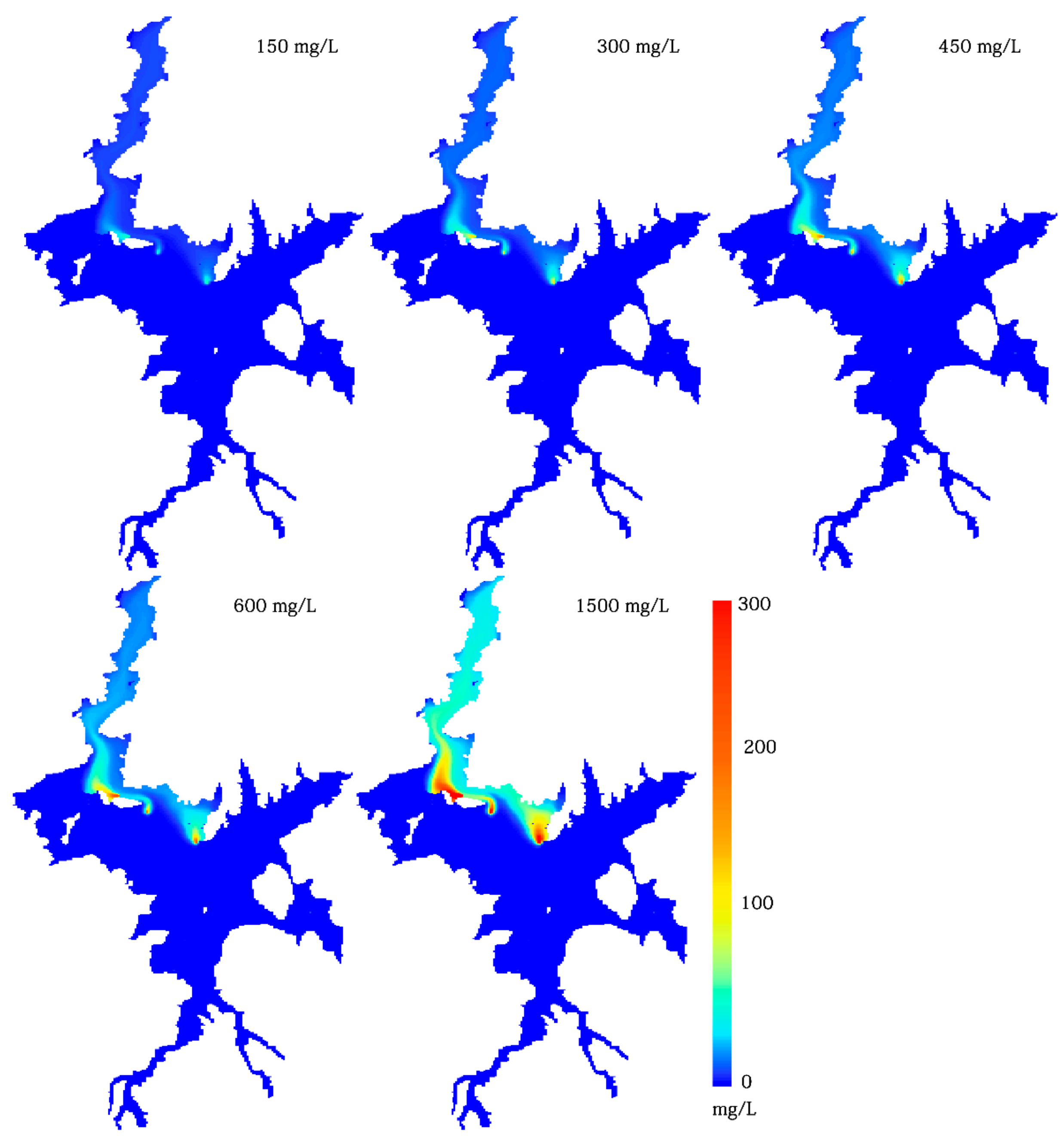
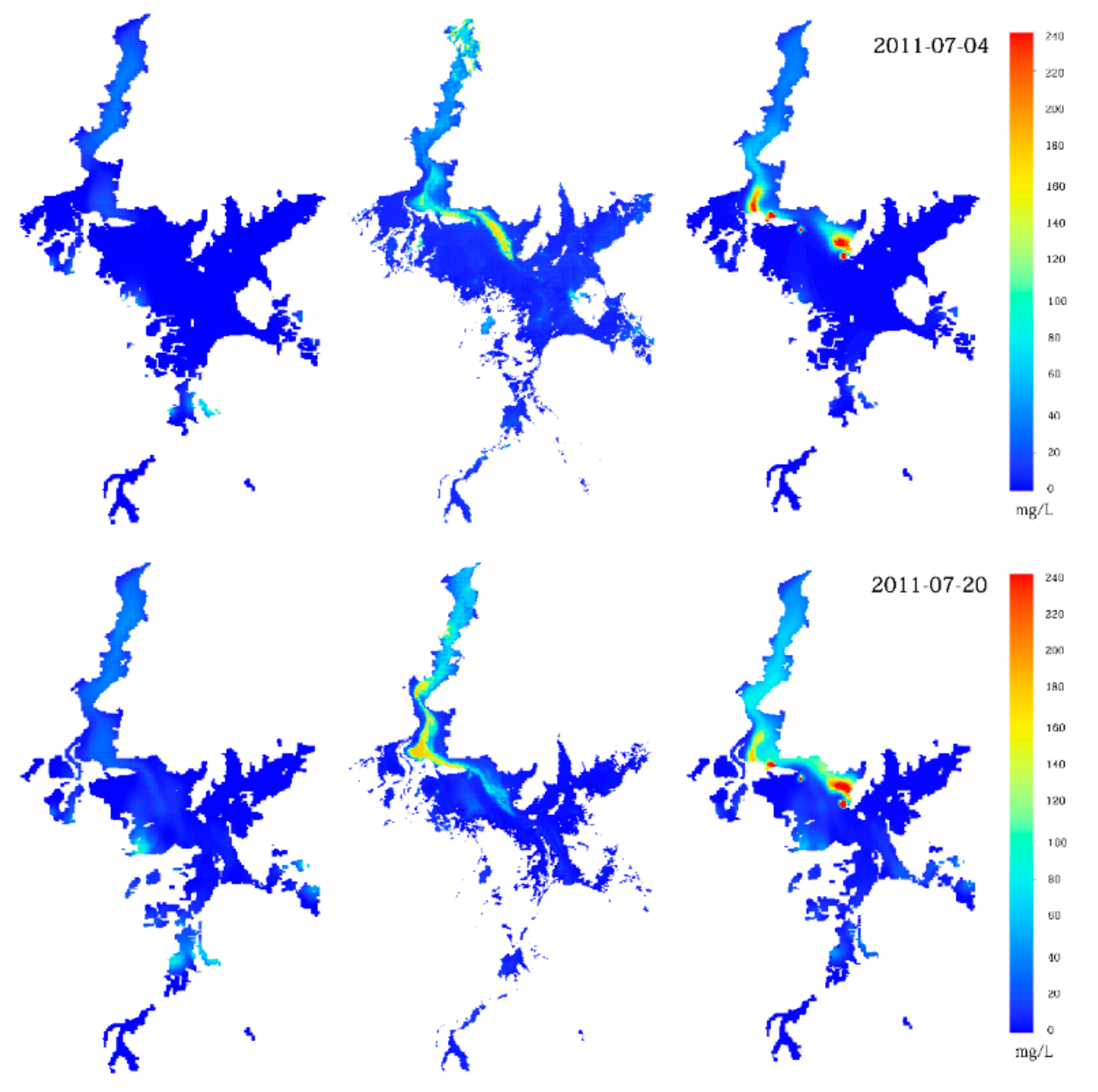
4.2. Simulation of Sand Dredging Effects on the Suspended Sediment Concentration
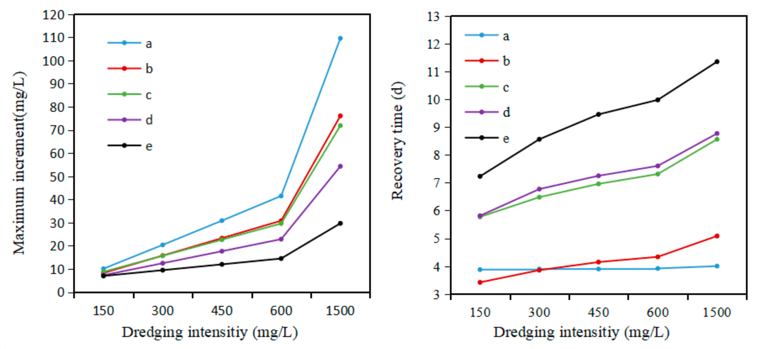
4.3. Spatial and Temporal Impacts of Dredging on the Suspended Sediment in Poyang Lake
5. Conclusions
Author Contributions
Funding
Acknowledgments
Conflicts of Interest
References
- Vos, R.J.; Brummelhuis, P.G.J.T.; Gerritsen, H. Integrated data-modelling approach for suspended sediment transport on a regional scale. Coast. Eng. 2000, 41, 177–200. [Google Scholar] [CrossRef]
- Miller, R.L.; Castillo, C.E.D.; Chilmakuri, C.; Mccorquodale, J.A. Using MULTI-temporal MODIS 250 m Data to Calibrate and Validate a Sediment Transport Model for Environmental Monitoring of Coastal Waters. In Proceedings of the IEEE International Workshop on the Analysis of Multi-Temporal Remote Sensing Images, Biloxi, MS, USA, 16–18 May 2005; Volume 62, pp. 200–204. [Google Scholar] [CrossRef]
- Kunte, P.D.; Zhao, C.; Osawa, T.; Sugimori, Y. Sediment distribution study in the Gulf of Kachchh, India, from 3D hydrodynamic model simulation and satellite data. J. Mar. Syst. 2005, 55, 139–153. [Google Scholar] [CrossRef]
- Elias, E.P.L.; Cleveringa, J.; Buijsman, M.C.; Roelvink, J.A.; Sive, M.J.F. Field and model data analysis of sand transport patterns in Texel Tidal inlet (The Netherlands). Coast. Eng. 2006, 53, 505–529. [Google Scholar] [CrossRef]
- Fettweis, M.; Nechad, B.; Van den Eynde, D. An estimate of the suspended particulate matter (SPM) transport in the southern North Sea using SeaWiFS images, in situ measurements and numerical model results. Cont. Shelf Res. 2007, 27, 1568–1583. [Google Scholar] [CrossRef]
- Chen, X.; Lu, J.; Cui, T.; Jiang, W.; Tian, L.; Chen, L.; Zhao, W. Coupling remote sensing retrieval with numerical simulation for SPM study—Taking Bohai Sea in China as a case. Int. J. Appl. Earth Obs. Geoinform. 2010, 12, 203–211. [Google Scholar] [CrossRef]
- Liang, D.; Lu, D.; Chen, X.; Zhang, L. Numerical simulation of hydrological and hydrodynamic responses to channel erosion in China’s largest freshwater lake. Appl. Ecol. Environ. Res. 2019, 17, 6865–6886. [Google Scholar] [CrossRef]
- Hossain, S.; Eyre, B.D.; McKee, L.J. Impacts of dredging on dry season suspended sediment concentration in the Brisbane River Estuary, Queensland, Australia. Estuar. Coast. Shelf S. 2004, 61, 539–545. [Google Scholar] [CrossRef]
- Thibodeaux, L.; Duckworth, K. The Effectiveness of Environmental Dredging: A Study of Three Sites. Remediation 2001, 11, 5–33. [Google Scholar] [CrossRef]
- Alam, S.; Matin, M.A. Application of 2D morphological model to assess the response of Karnatuli River due to capital dredging. J. Water Resour. Ocean. Sci. 2013, 2, 40–48. [Google Scholar] [CrossRef]
- Jeroen, S. The Influence of Dredging Activities on the Morphological Development of the Columbia River Mouth. MSc Thesis, Department of Hydraulic Engineering Section of Coastal Engineering, Delft University of Technology, TU Delft, Delft, The Netherlands, 2012. [Google Scholar]
- Cheng, X.; Wan, Y.; Cao, B. Identification of sand dredges in Yangtze River based on ASAR remote sensing data. In Proceedings of the 17th International Conference on Geoinformatics, IEEE, Fairfax, VA, USA, 12–14 August 2009; pp. 1–5. [Google Scholar] [CrossRef]
- Evans, R.D.; Murray, K.L.; Field, S.N.; Moore, J.A.; Shedrawi, G.; Huntley, B.G.; Fearms, P.; Broomhall, M.; Mckinna, L.I.; Marrable, D. Digitise this! A quick and easy remote sensing method to monitor the daily extent of dredge plumes. PLoS ONE 2012, 7, 16733–16737. [Google Scholar] [CrossRef]
- He, M.X.; Hu, L.; Hu, C. Harbour dredging and fish mortality in an aquaculture zone: Assessment of changes in suspended particulate matter using multi-sensor remote-sensing data. Int. J. Remote Sens. 2014, 35, 4383–4398. [Google Scholar] [CrossRef]
- Islam, M.A.; Wang, L.; Smith, C.; Reddy, R.; Lewis, A.; Smith, A. Evaluation of satellite remote sensing for operational monitoring of sediment plumes produced by dredging at Hay Point, Queensland, Australia. J. Appl. Remote Sens. 2007, 1, 011506. [Google Scholar] [CrossRef]
- Sipelgas, L.; Raudsepp, U. Monitoring of HARBOR dredging Using Remote Sensing and Optical In Situ Data. In Proceedings of the IEEE International Geoscience and Remote Sensing Symposium, Cape Town, South Africa, 12–17 August 2009; pp. II-476–II-478. [Google Scholar] [CrossRef]
- Lu, J.; Chen, X.; Zhang, P.; Huang, J. Evaluation of spatiotemporal differences in suspended sediment concentration derived from remote sensing and numerical simulation for coastal waters. J. Coast. Conserv. 2017, 21, 197–207. [Google Scholar] [CrossRef]
- Jordan, Y.C.; Ghulam, A.; Hartling, S. Traits of surface water pollution under climate and land use changes: A remote sensing and hydrological modeling approach. Earth-Sci. Rev. 2014, 128, 181–195. [Google Scholar] [CrossRef]
- Milzow, C.; Kgotlhang, L.; Kinzelbach, W.; Meier, P.; Bauer-Gottein, P. The role of remote sensing in hydrological modelling of the Okavango Delta, Botswana. J. Environ. Manag. 2009, 90, 2252–2260. [Google Scholar] [CrossRef]
- Oey, L.-Y.; Ezer, T.; Hu, C.; Muller-Karger, F.E. Baroclinic tidal flows and inundation processes in Cook Inlet, Alaska: Numerical modeling and satellite observations. Ocean. Dynam. 2007, 57, 205–221. [Google Scholar] [CrossRef]
- Van Dongeren, A.; Plant, N.; Cohen, A.; Roelvink, D.; Haller, M.C.; Catalan, P. Beach Wizard: Nearshore bathymetry estimation through assimilation of model computations and remote observations. Coast. Eng. 2008, 55, 1016–1027. [Google Scholar] [CrossRef]
- Feng, L.; Hu, C.; Chen, X.; Cai, X.; Tian, L.; Gan, W. Assessment of inundation changes of Poyang Lake using MODIS observations between 2000 and 2010. Remote Sens. Environ. 2012, 121, 80–92. [Google Scholar] [CrossRef]
- Wu, G.; Cui, L. Remote sense-based analysis of sand dredging impact on water clarity in Poyang Lake. Acta Ecol. Sin. 2008, 28, 6113–6120. (in Chinese). [Google Scholar]
- Cui, L.; Qiu, Y.; Fei, T.; Wu, G. Using remotely sensed suspended sediment concentration variation to improve management of Poyang Lake, China. Lake Reserv. Manag. 2013, 29, 47–60. [Google Scholar] [CrossRef]
- Lai, X.; Shankman, D.; Huber, C.; Yeou, H.; Huang, Q.; Jiang, J. Sand mining and increasing Poyang Lake’s discharge ability: A reassessment of causes for lake decline in China. J. Hydrol. 2014, 519, 1698–1706. [Google Scholar] [CrossRef]
- Li, J.; Tian, L.; Chen, X.; Li, X.; Lu, J.; Feng, L. Remote-sensing monitoring for spatio-temporal dynamics of sand dredging activities at Poyang Lake in China. Int. J. Remote Sens. 2014, 35, 6004–6022. [Google Scholar] [CrossRef]
- Chen, X.; Wu, Z.; Tian, L.; Chen, L. Inversion model for dynamic monitoring of suspended sediment: A case study on Poyang Lake. Sci. Technol. Rev. 2007, 25, 19–22. [Google Scholar] [CrossRef]
- Wu, G.; Cui, L.; Duan, H.; Fei, T.; Liu, Y. An approach for developing Landsat-5 TM-based retrieval models of suspended particulate matter concentration with the assistance of MODIS. ISPRS J. Photogramm. 2013, 85, 84–92. [Google Scholar] [CrossRef]
- Wu, G.; Cui, L.; He, J.; Duan, H.; Fei, T.; Liu, Y. Comparison of MODIS-based models for retrieving suspended particulate matter concentrations in Poyang Lake, China. Int. J. Appl. Earth Obs. 2013, 24, 63–72. [Google Scholar] [CrossRef]
- Zhang, P.; Wai, O.W.H.; Chen, X.; Lu, J.; Tian, L. Improving Sediment Transport Prediction by Assimilating Satellite Images in a Tidal Bay Model of Hong Kong. Water 2014, 6, 642–660. [Google Scholar] [CrossRef]
- Leeuw, J.; Shankman, D.; Wu, G.; de Boer, W.F.; Burnham, J.; He, Q.; Yesou, H.; Xiao, J. Strategic assessment of the magnitude and impacts of sand mining in Poyang Lake, China. Reg. Environ. Chang. 2009, 10, 95–102. [Google Scholar] [CrossRef]
- Zhang, P.; Lu, J.; Feng, L.; Chen, X.; Zhang, L.; Xiao, X.; Liu, H. Hydrodynamic and Inundataion modeling of China’s Largest Freshwater Lake aided by remote sensing data. Remote Sens. 2015, 7, 4858–4879. [Google Scholar] [CrossRef]
- Feng, L.; Hu, C.; Chen, X.; Tian, L.; Chen, L. Human induced turbidity changes in Poyang Lake between 2000 and 2010: Observations from MODIS. J. Geophys. Res.-Oceans 2012, 117. [Google Scholar] [CrossRef]
- Gao, J.; Jia, J.; Kettner, A.J.; Xing, F.; Wang, Y.; Xu, X.; Yang, Y.; Zou, X.; Gao, S.; Qi, S.; et al. Changes in water and sediment exchange between the Yangtze River and Poyang Lake under natural and anthropogenic conditions, China. Sci. Total Environ. 2014, 481, 542–553. [Google Scholar] [CrossRef]
- Huete, A.; Didan, K.; Miura, T.; Rodriguez, E.P.; Gao, X.; Ferreira, L.G. Overview of the radiometric and biophysical performance of the MODIS vegetation indices. Remote Sens. Environ. 2002, 83, 195–213. [Google Scholar] [CrossRef]
- Delft Hydraulics. Delft3d-Flow User Manual: Simulation of Multi-Dimensional Hydrodynamic Flows and Transport Phenomena, Including Sediments; Deltares: Delft, The Netherlands, 2014; pp. 1–683. [Google Scholar]
- Lesser, G.; Roelvink, J.; van Kester, J.; Stelling, G. Development and validation of a three-dimensional morphological model. Coast. Eng. 2004, 51, 883–915. [Google Scholar] [CrossRef]
- Zhang, P.; Chen, X.; Lu, J.; Zhang, W. Assimilation of remote sensing observations into a sediment transport model of China’s largest freshwater lake: Spatial and temporal effects. Environ. Sci. Pollut. Res. 2015, 22, 18779–18792. [Google Scholar] [CrossRef] [PubMed]
- Tang, L.; Xiao, Y.; Zhou, H.; Luo, J.; Tang, H. Research on the effect factors of flow diversion ratio in Ganjiang River. Hydro-Sci. Eng. 2011, 27, 64–68. [Google Scholar] [CrossRef]
- Zhang, P.; Chen, X.; Lu, J.; Zhang, W.; Xiao, X. Suspended sediment transport modeling of Poyang Lake in the wet season based on remote sensing data. Geomat. Inform. Sci. Wuhan Univ. 2017, 42, 369–376. [Google Scholar] [CrossRef]
- Pennekamp, J.G.S.; Epskamp, R.J.C.; Rosenbrand, W.F.; Mullie, A.; Wessel, G.L.; Arts, T.; Deibel, I.K. Turbidity caused by dredging: Viewed in perspective. Terra Aqua 1996, 64, 10–17. [Google Scholar]
- Li, Y.; Acharya, K.; Chen, D.; Stone, M. Modeling water ages and thermal structure of Lake Mead under changing water levels. Lake Reserv. Manag. 2010, 26, 258–272. [Google Scholar] [CrossRef]
- Qi, H.; Lu, J.; Chen, X.; Sauvage, S.; Sanchez-Perez, J.-M. Water age prediction and its potential impacts on water quality using a hydrodynamic model for Poyang Lake, China. Environ. Sci. Pollut. Res. 2016, 23, 13327–13341. [Google Scholar] [CrossRef]


© 2019 by the authors. Licensee MDPI, Basel, Switzerland. This article is an open access article distributed under the terms and conditions of the Creative Commons Attribution (CC BY) license (http://creativecommons.org/licenses/by/4.0/).
Share and Cite
Lu, J.; Li, H.; Chen, X.; Liang, D. Numerical Study of Remote Sensed Dredging Impacts on the Suspended Sediment Transport in China’s Largest Freshwater Lake. Water 2019, 11, 2449. https://doi.org/10.3390/w11122449
Lu J, Li H, Chen X, Liang D. Numerical Study of Remote Sensed Dredging Impacts on the Suspended Sediment Transport in China’s Largest Freshwater Lake. Water. 2019; 11(12):2449. https://doi.org/10.3390/w11122449
Chicago/Turabian StyleLu, Jianzhong, Haijun Li, Xiaoling Chen, and Dong Liang. 2019. "Numerical Study of Remote Sensed Dredging Impacts on the Suspended Sediment Transport in China’s Largest Freshwater Lake" Water 11, no. 12: 2449. https://doi.org/10.3390/w11122449
APA StyleLu, J., Li, H., Chen, X., & Liang, D. (2019). Numerical Study of Remote Sensed Dredging Impacts on the Suspended Sediment Transport in China’s Largest Freshwater Lake. Water, 11(12), 2449. https://doi.org/10.3390/w11122449