Flood Simulations in Mid-Latitude Agricultural Land Using Regional Current and Future Extreme Weathers

 , ,
, ,
Abstract
1. Introduction
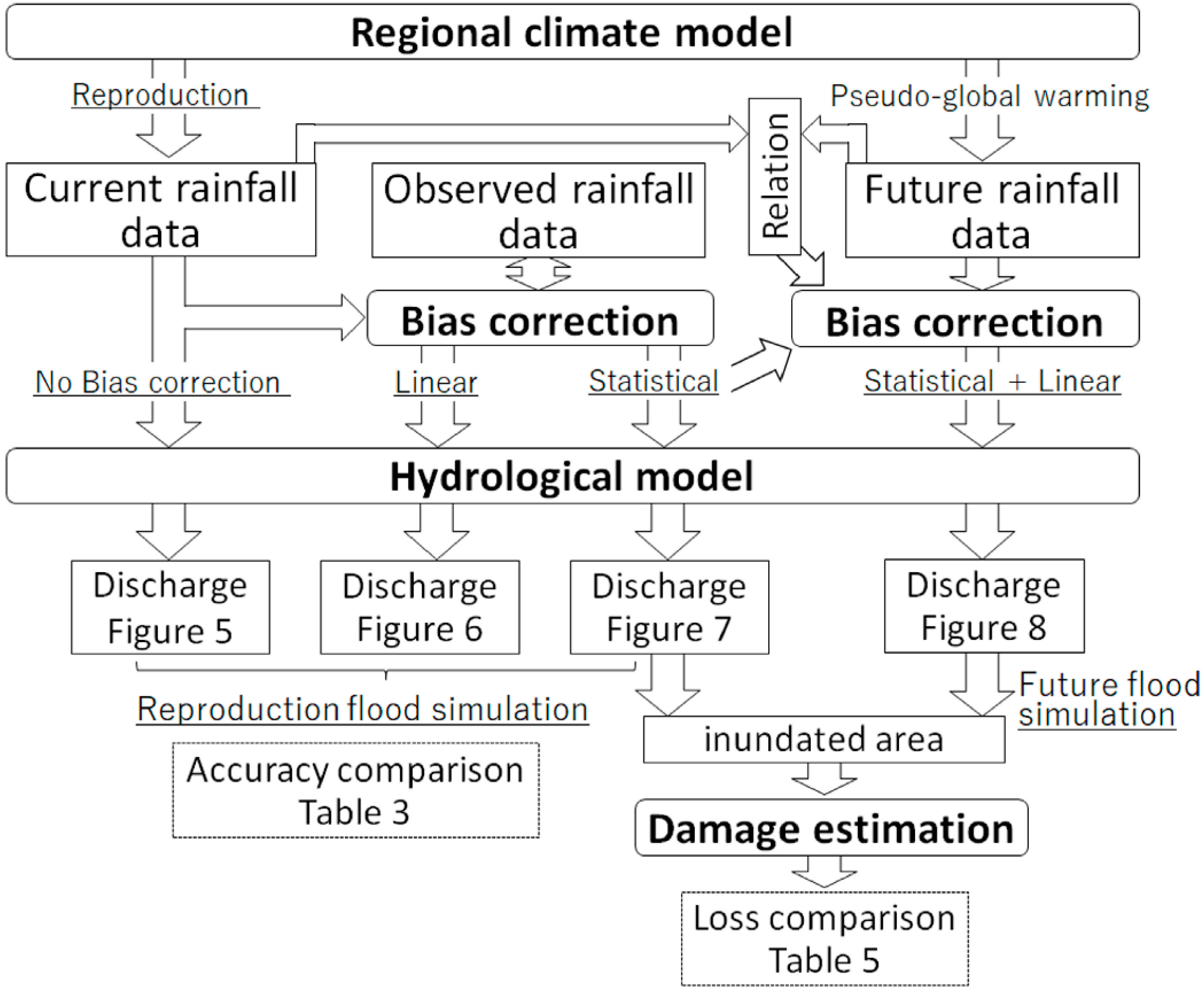
2. Methods
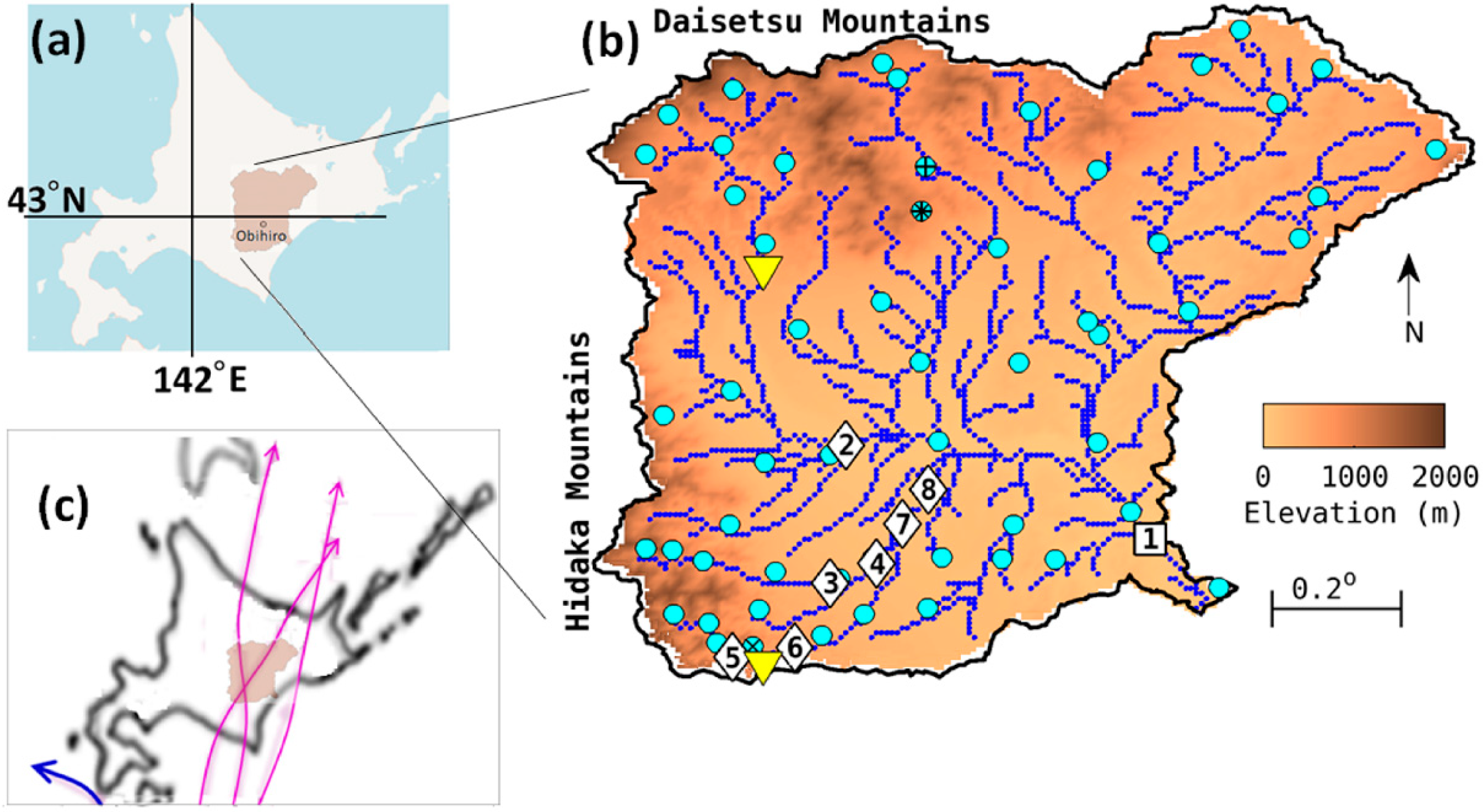
2.1. Study Site
2.2. Integrated Flood Analysis System (IFAS)
2.3. Data Inputs
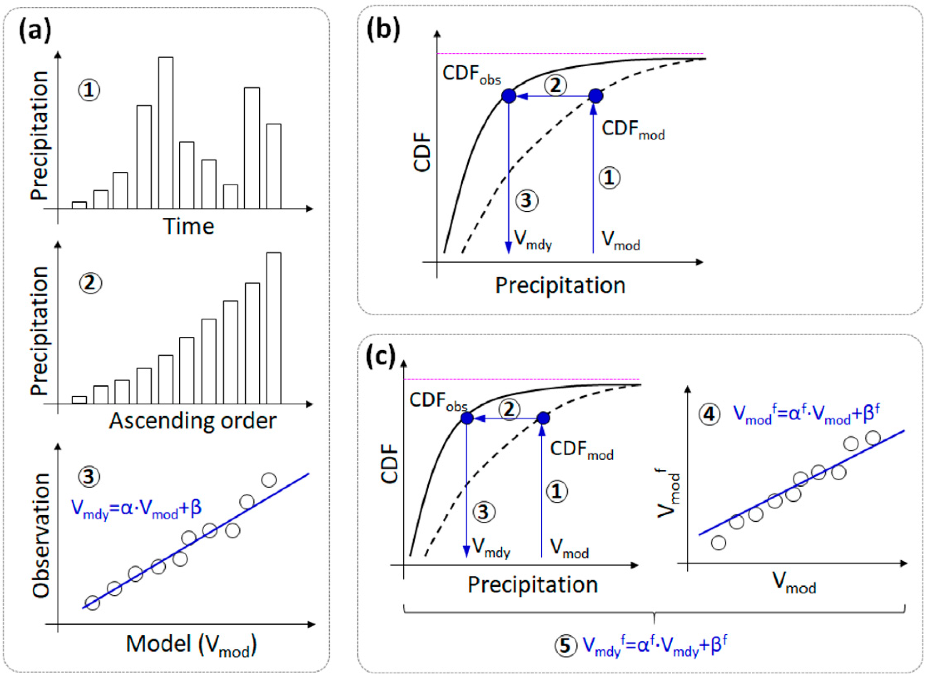
2.4. Rainfall Data and Bias Corrections
2.5. Simulation Preparations
2.6. Indicators for Model Validation
3. Results
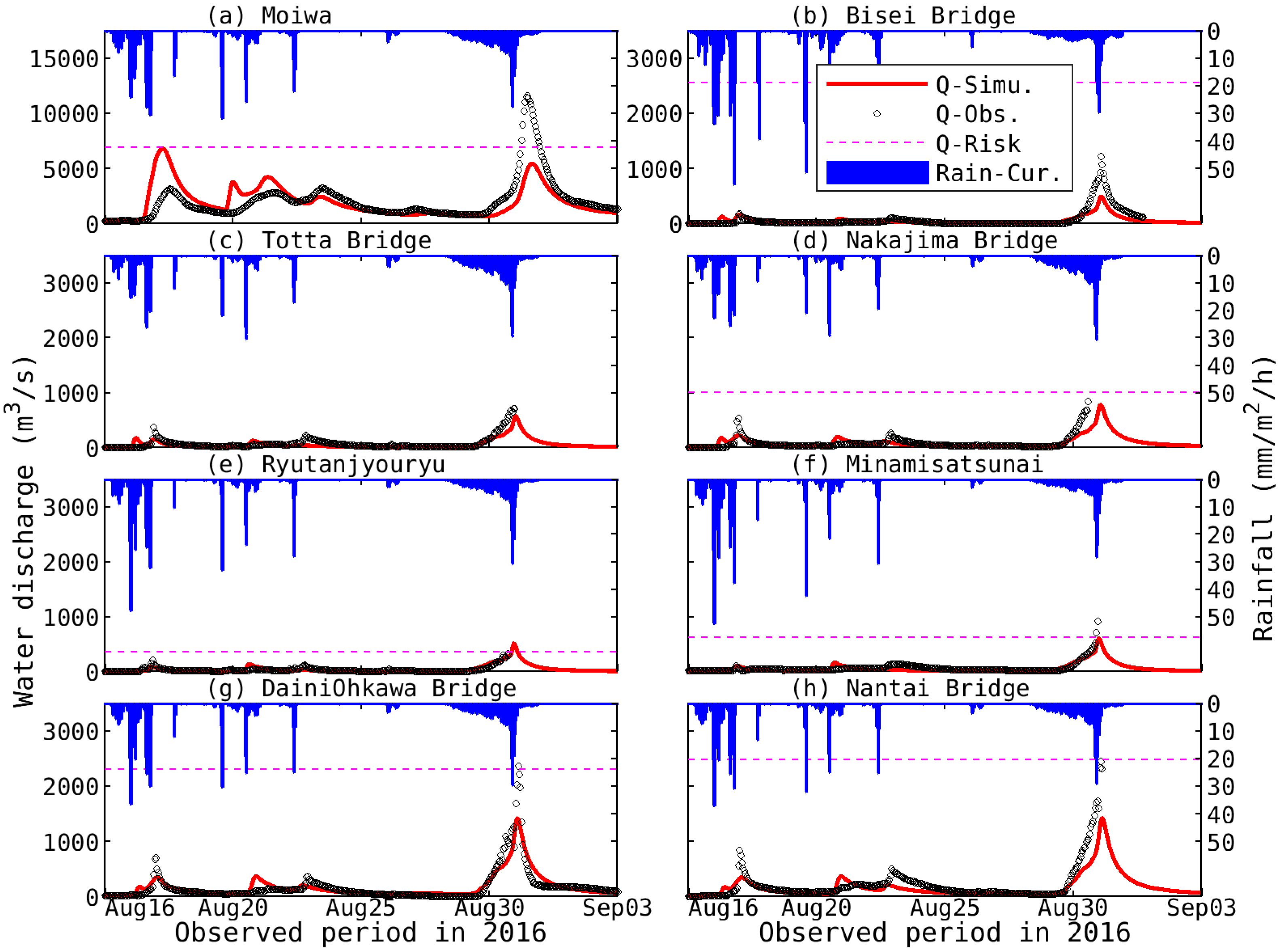
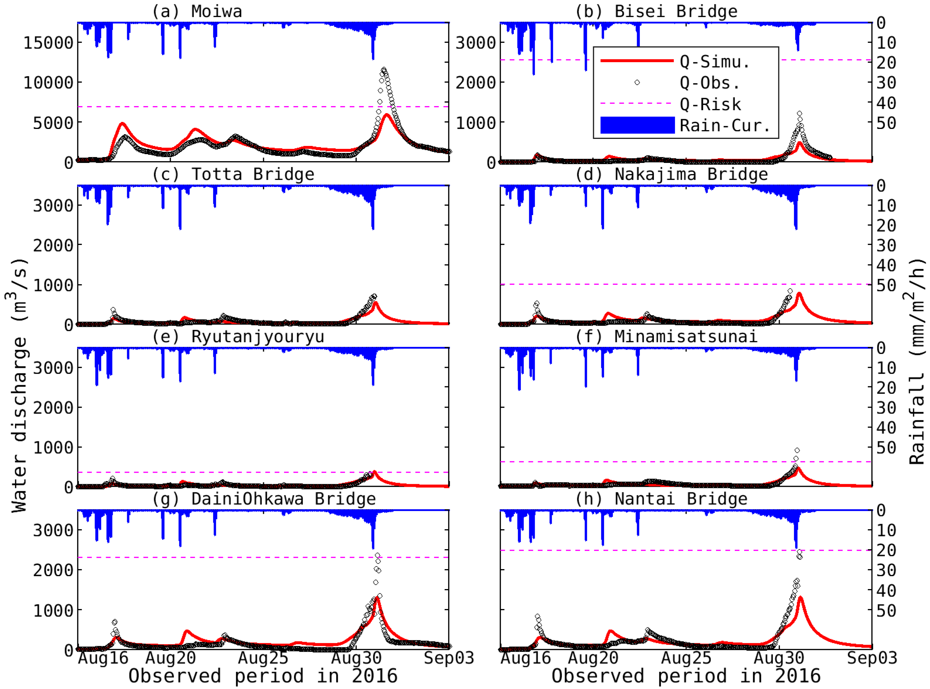
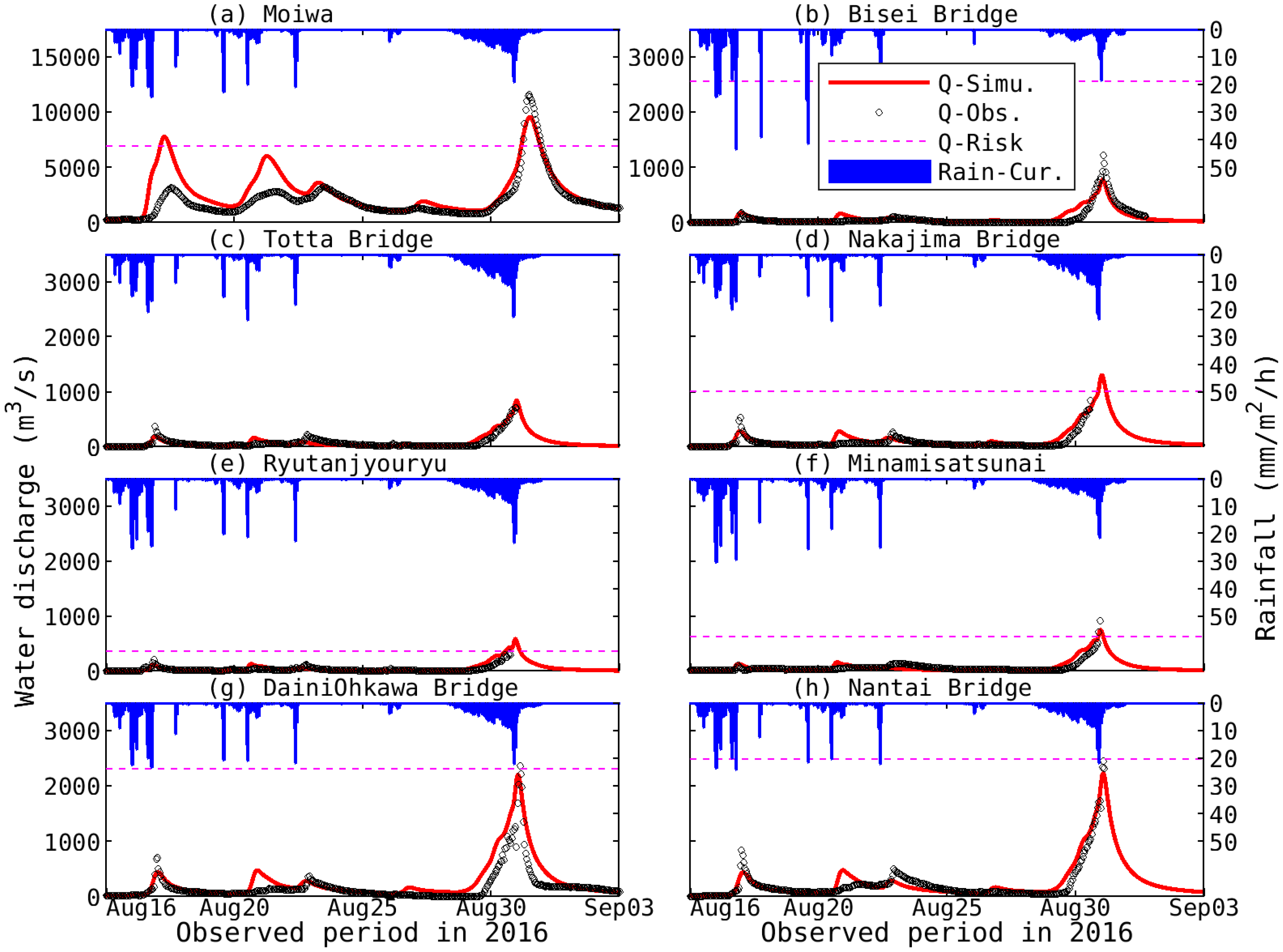
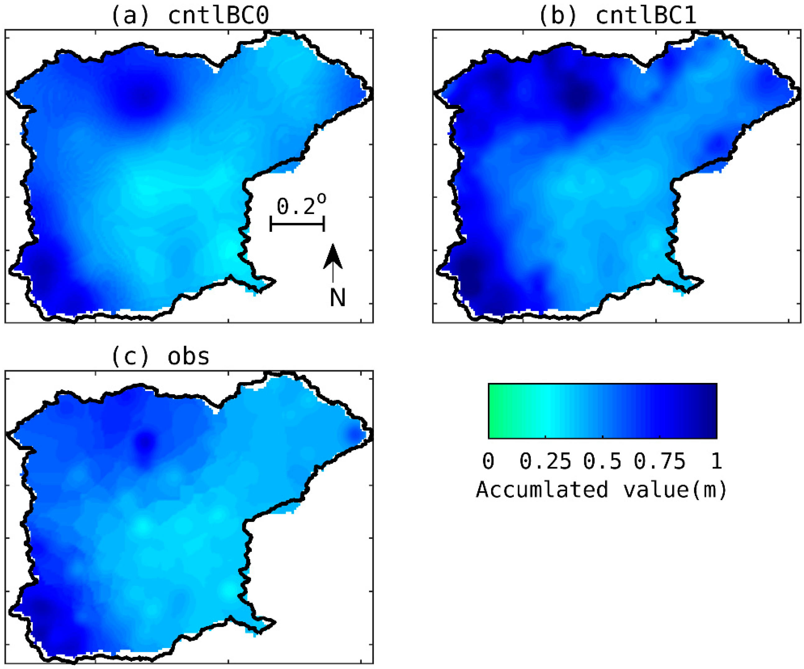
3.1. Hydrological Model Validation
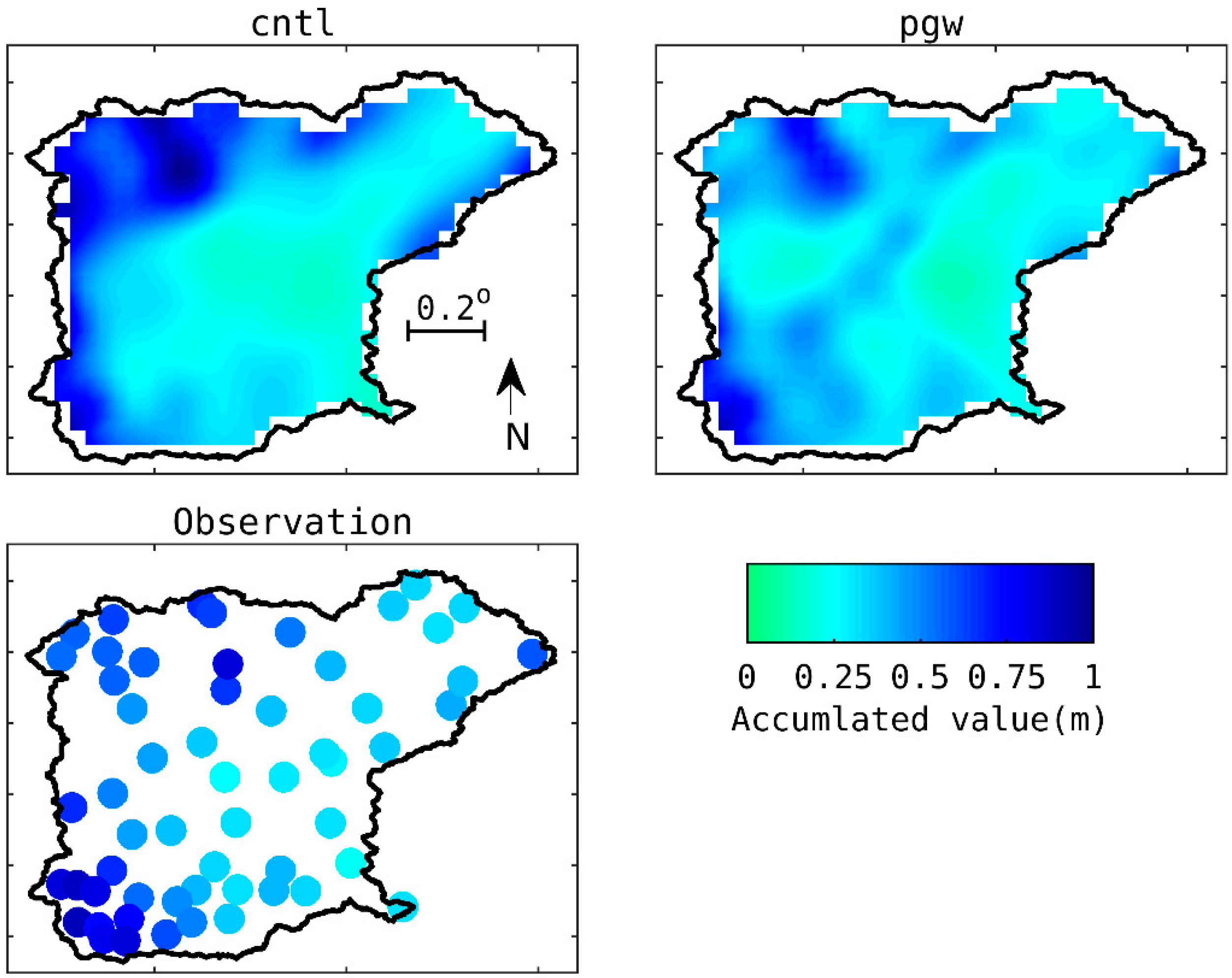
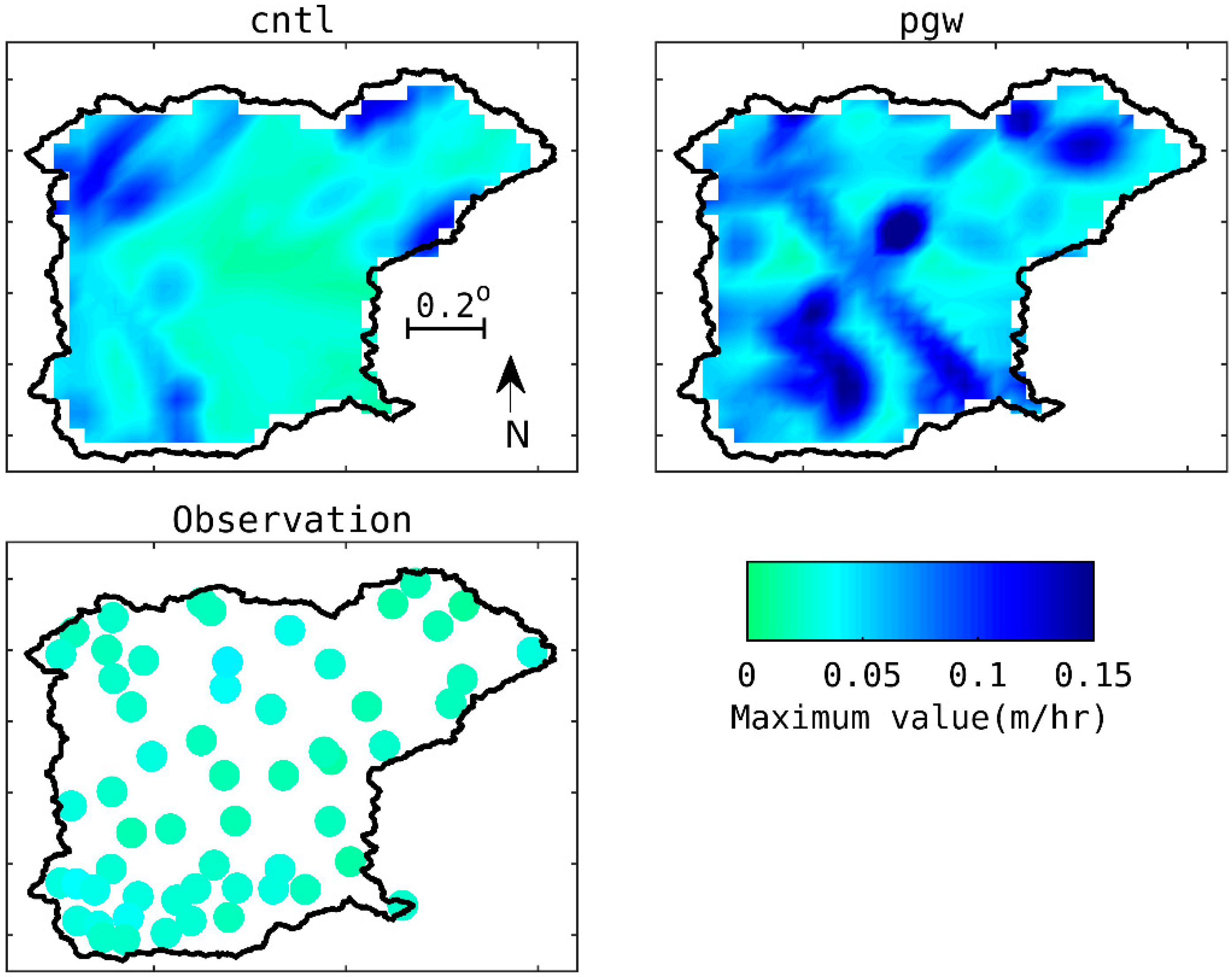
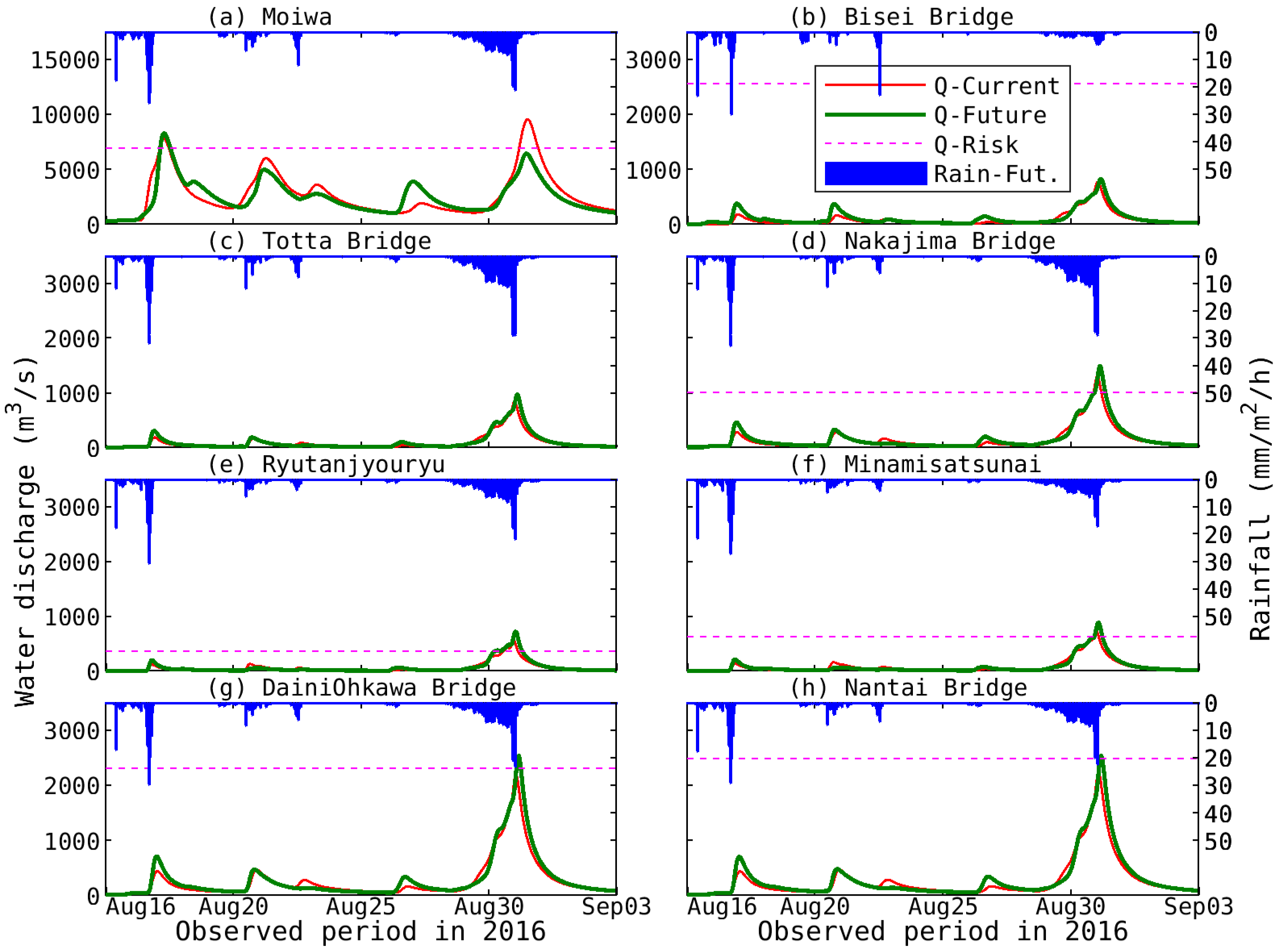
3.2. Future Flood Situation under GLOBAL WARNING
3.3. Estimation of Agricultural Damage Loss
4. Discussion
5. Conclusions
Author Contributions
Funding
Acknowledgments
Conflicts of Interest
Appendix A

Appendix B


References
- Intergovernmental Panel on Climate Change (IPCC). Managing the Risks of Extreme Events and Disasters to Advance Climate Change Adaptation; A special report of working groups I and II of the IPCC; Field, C.B., Barros, V., Stocker, T.F., Qin, D., Dokken, D.J., Ebi, K.L., Mastrandrea, M.D., Mach, K.J., Plattner, G.K., Allen, S.K., et al., Eds.; Cambridge University Press: Cambridge, UK; New York, NY, USA, 2012; 582p. [Google Scholar]
- IPCC Climate Change 2014: Synthesis Report. Contribution of Working Groups I, II and III to the Fifth Assessment Report of the Intergovernmental Panel on Climate Change; Core Writing Team, Pachauri, R.K., Meyer, L.A., Eds.; IPCC: Geneva, Switzerland, 2014; 151p. [Google Scholar]
- Myeong, S.; Hong, H.J. Developing flood vulnerability map for North Korea. In Proceedings of the American Society for Photogrammetry and Remote Sensing Annual Conference 2009, Baltimore, MD, USA, 9–13 March 2009. [Google Scholar]
- Japan Meteorological Agency (JMA)—The Regional Specialized Meteorological Center (RSMC) Tokyo—Typhoon Center. Available online: http://www.jma.go.jp/jma/jma-eng/jma-center/rsmc-hp-pub-eg/RSMC_HP.htm (accessed on 31 July 2019).
- JMA. Past Meteorological Data in 2017. Available online: http://www.data.jma.go.jp/obd/stats/data/bosai/report/2017/20170922/jyun_sokuji20170913-0918.pdf (accessed on 31 July 2019). (In Japanese).
- JMA. Past Meteorological Data in 2018. Available online: http://www.data.jma.go.jp/obd/stats/data/bosai/report/2018/20180713/jyun_sokuji20180628-0708.pdf (accessed on 31 July 2019). (In Japanese).
- Japan Society of Civil Engineers (JSCE). Onsite Field Investigation Team, Site-Investigation Report for the Hokkaido Heavy Rain Disasters in August 2016; JSCE report 2017; JSCE: Tokyo, Japan, 2017; 141p. (In Japanese) [Google Scholar]
- Ministry of Land, Infrastructure, Transport, and Tourism in Japan (MLIT Japan). Hydrology and Water Quality Database. Available online: http://www1.river.go.jp/ (accessed on 31 July 2019). (In Japanese).
- Kitano, Y.; Yamamoto, T.; Kobayashi, A.; Yamada, T.J. Statistical analysis of typhoon related events in Hokkaido and surroundings in the last 56 years including the 2016 heavy rainfall. J. Jpn. Soc. Civ. Eng. Ser. B1 (Hydraul. Eng.) 2017, 73, I_1231–I_1236. (In Japanese) [Google Scholar] [CrossRef]
- Hoshino, T.; Yamada, T.J. Analysis of annual maximum precipitation over first-class river basins in Japan using a large-ensemble dataset(d4PDF). J. Jpn. Soc. Civ. Eng. Ser. B1 (Hydraul. Eng.) 2018, 74, I_187–I_192. (In Japanese) [Google Scholar]
- Yamada, T.J.; Inatsu, M.; Sato, T.; Hoshino, T.; Nguyen-Le, D.; Hatsuzuka, D.; Sugimoto, S.; Kawase, H. Assessment of Flood Risk in Hokkaido Associated with Climate Change, Annual Report of the Earth Simulator (April 2017–March 2018). Available online: https://www.jamstec.go.jp/ceist/j/publication/annual/annual2017/pdf/2project/chapter3/3-3-2_yamada.pdf (accessed on 31 July 2019).
- Mizuta, R.; Murata, A.; Ishii, M. Over 5000 years of ensemble future climate simulations by 60 km global and 20 km regional atmospheric models. Bull. Am. Meteorol. Soc. 2016, 98, 1383–1393. [Google Scholar] [CrossRef]
- Kanada, S.; Tsuboki, K.; Aiki, H.; Tsujino, S.; Takayabu, I. Future enhancement of heavy rainfall events associated with a typhoon in the midlatitude regions. SOLA 2017, 13, 246–251. [Google Scholar] [CrossRef]
- MLIT Japan. Future Countermeasures for Flood Controls with the Consideration of the Hokkaido Heavy-Rain Disaster in August 2016—Supplementary Material. Available online: https://www.hkd.mlit.go.jp/ky/kn/kawa_kei/ud49g7000000f0l0-att/splaat000000hdsv.pdf (accessed on 31 July 2019). (In Japanese).
- Kimura, N.; Kiri, H.; Kitagawa, I. The Impact of Multiple Typhoons on Severe Floods in the Mid-Latitude Region (Hokkaido). Water 2018, 10, 843. [Google Scholar] [CrossRef]
- Ministry of Agriculture, Forestry and Fisheries Japan. FY2018 Summary of the Annual Report on Food, Agriculture and Rural Areas in Japan. Available online: http://www.maff.go.jp/j/wpaper/w_maff/h30/attach/pdf/index-28.pdf (accessed on 31 July 2019).
- Hokkaido Regional Development Bureau in MLIT Japan. Obihiro office website. Available online: https://www.hkd.mlit.go.jp/ob/obihiro_kasen/index.html (accessed on 31 July 2019). (In Japanese).
- Fukami, K.; Sugiura, Y.; Magome, J.; Kawakami, T. Integrated Flood Analysis System (IFAS Ver. 1.2)—User’s Manual; Japan PWRI-technical note; The Public Works Research Institute: Tsukuba, Japan, 2009; 223p, No.4148; ISSN 0386-5878. [Google Scholar]
- International Centre for Water Hazard and Risk Management (ICHARM). IFAS Flood Forecasting System Using Global Satellite Rainfall. Available online: http://www.icharm.pwri.go.jp/research/ifas/ (accessed on 31 July 2019).
- Aziz, A.; Tanaka, S. Regional parameterization and applicability of Integrated Flood Analysis System (IFAS) for flood forecasting of upper-middle Indus River. Pak. J. Meteorol. 2011, 8, 21–38. [Google Scholar]
- Liu, T.; Tsuda, M.; Iwami, Y. A study on flood forecasting in the upper Indus basin considering snow and glacier meltwater. J. Disaster Res. 2017, 12, 793–805. [Google Scholar] [CrossRef]
- Kimura, N.; Chiang, S.; Wei, H.P.; Su, Y.F.; Chu, J.L.; Cheng, C.T.; Liou, J.J.; Chen, Y.M.; Lin, L.Y. Hydrological flood simulation to Tsengwen reservoir watershed under global climate change with 20 km mesh Meteorological Research Institute atmospheric general circulation model (MRI-AGCM). Terr. Atmos. Ocean. Sci. 2014, 25, 449–461. [Google Scholar] [CrossRef]
- Yoshino, F.; Yoshitani, J.; Sugiura, M. A conceptual distributed model for large-scale mountainous basins. In Hydrology of Mountainous Regions, I—Hydrological Measurements; the water cycle; Lang, H., Musy, A., Eds.; IAHS Publisher: Lausanne, Switzerland, 1990; pp. 685–692. [Google Scholar]
- Hydrological Data and Maps Based on Shuttle Elevation Derivatives at Multiple Scales (HydroSHEDS). Available online: https://www.hydrosheds.org/ (accessed on 31 July 2019).
- Global Land Cover Characterization (GLCC). Available online: https://www.usgs.gov/centers/eros/science/usgs-eros-archive-land-cover-products-global-land-cover-characterization-glcc?qt-science_center_objects=0#qt-science_center_objects (accessed on 31 July 2019).
- Aiki, H.; Yoshioka, M.; Kato, M.; Morimoto, A.; Shinoda, T.; Tsuboki, K. A coupled atmosphere-ocean-surface-wave modeling system for understanding air-sea interactions under tropical cyclone conditions. Bull. Coast. Oceanogr. 2015, 52, 139–148. [Google Scholar]
- Tsuboki, K.; Sakakibara, A. Large-scale parallel computing of Cloud Resolving Storm Simulator. In High Performance Computing; Zima, H.P., Joe, K., Sato, M., Seo, Y., Shimasaki, M., Eds.; Springer: New York, NY, USA, 2002; pp. 243–259. [Google Scholar]
- Aiki, H.; Takahashi, K.; Yamagata, T. The Red Sea outflow regulated by the Indian Monsoon. Cont. Shelf Res. 2006, 26, 1448–1468. [Google Scholar] [CrossRef]
- Aiki, H.; Matthews, J.P.; Lamb, K.G. Modeling and energetics of tidally generated wave trains in the Lombok Strait: Impact of the Indonesian Throughflow. J. Geophys. Res. 2011, 116, C03023. [Google Scholar] [CrossRef]
- Kobayashi, S.; Ota, Y.; Harada, Y.; Ebita, A. The JRA-55 reanalysis: General specifications and basic characteristics. J. Meteorol. Soc. Jpn. 2015, 93, 5–48. [Google Scholar] [CrossRef]
- Miyazawa, Y.; Zhang, R.; Guo, X.; Tamura, H.; Ambe, D.; Lee, J.S.; Okuno, A.; Yoshinari, H.; Setou, T.; Komatsu, K. Water mass variability in the western North Pacific detected in a 15-year eddy resolving ocean reanalysis. J. Oceanogr. 2009, 65, 737–756. [Google Scholar] [CrossRef]
- Mizuta, R.; Yoshimura, H.; Murakami, H.; Matsueda, M.; Endo, H.; Ose, T.; Kamiguchi, K.; Hosaka, M.; Sugi, M.; Yukimoto, S.; et al. Climate simulations using MRI-AGCM3.2 with 20-km grid. J. Meteorol. Soc. Jpn. 2012, 90, 233–258. [Google Scholar] [CrossRef]
- Mizuta, R.; Arakawa, O.; Ose, T.; Kusunoki, S.; Endo, H.; Kitoh, A. Classification of CMIP5 future climate responses by the tropical sea surface temperature changes. SOLA 2014, 10, 167–171. [Google Scholar] [CrossRef]
- Piani, C.; Weedon, G.P.; Best, M.; Gomes, S.M.; Viterbo, P.; Hagemann, S.; Haerter, J.O. Statistical Bias Correction of Global Simulated Daily Precipitation and Temperature for the Application of Hydrological Models. J. Hydrol. 2010, 395, 99–215. [Google Scholar] [CrossRef]
- JMA. Past Meteorological Data. Available online: http://www.data.jma.go.jp/gmd/risk/obsdl/index.php (accessed on 31 July 2019).
- Nash, J.E.; Sutcliffe, J.V. River flow forecasting through conceptual models, part I—A discussion of principles. J. Hydrol. 1970, 10, 282–290. [Google Scholar] [CrossRef]
- Obihiro Office in the Hokkaido Agriculture, Forestry and Fisheries. The Statistical Annual Report from 2016 to 2017. Available online: http://www.maff.go.jp/hokkaido/toukei/kikaku/nenpou/28-29sougou/28-29sougou.html. (accessed on 31 July 2019). (In Japanese).
- Kazama, S.; Sato, A.; Kawagoe, S. Evaluating the cost of flood damage based on changes in extreme rainfall in Japan. Sustain. Sci. 2009, 4, 61–69. [Google Scholar] [CrossRef]
- Colle, B.; Mass, C.; Westrick, K. MM5 precipitation verification over the Pacific Northwest during the 1997–99 cool seasons. Weather Forecast. 2000, 15, 730–744. [Google Scholar] [CrossRef]
- Gutmann, E.; Rasmussen, R.M.; Liu, C.; Ikeda, K.; Gochis, D.J.; Clark, M. A comparison of statistical and dynamical downscaling of winter precipitation over complex terrain. J. Clim. 2012, 25, 262–281. [Google Scholar] [CrossRef]
- News Letter for Flood Disaster Reports in Memuro Town. Available online: http://www.memuro.net/soumu/bousai/pdf/saigai/smile_vol1-19.pdf (accessed on 31 July 2019). (In Japanese).
- Yamaura, K.; Sakaue, S.; Washida, T. Regional and Sectoral Impacts of Global Warming and Agricultural Production: A Case of CGE Analyses. Jpn. J. Agric. Econ. 2017, 19, 54–59. [Google Scholar] [CrossRef][Green Version]
- KAKUSHIN Program Innovative Program of Climate Change Projection for the 21st Century. Available online: https://www.jamstec.go.jp/kakushin21/eng/brochure/general%20report-e.pdf (accessed on 31 July 2019).
- Umetsu, C.; Palanisami, K.; Coşkun, Z.; Donma, S.; Nagano, T.; Fujihara, Y.; Tanaka, K. Climate Change and Alternative Cropping Patterns in Lower Seyhan Irrigation Project: A Regional Simulation Analysis with MRI-GCM and CSSR-GCM. In the final report of the Impact of Climate Change on Agricultural Projection system in the arid areas, Research Institute for Humanity and Nature and the Scientific and technological Research Council of Turkey, 231–243. Available online: http://www.chikyu.ac.jp/iccap/ICCAP_Final_Report/6/5-irrigation_umetsu.pdf (accessed on 31 July 2019).
- Pierce, D.; Cayan, D.; Maurer, E.; Abatzoglou, J.; Hegewisch, K. Improved bias correction techniques for hydrological simulations of climate change. J. Hydrometeorol. 2015, 16, 2421–2442. [Google Scholar] [CrossRef]


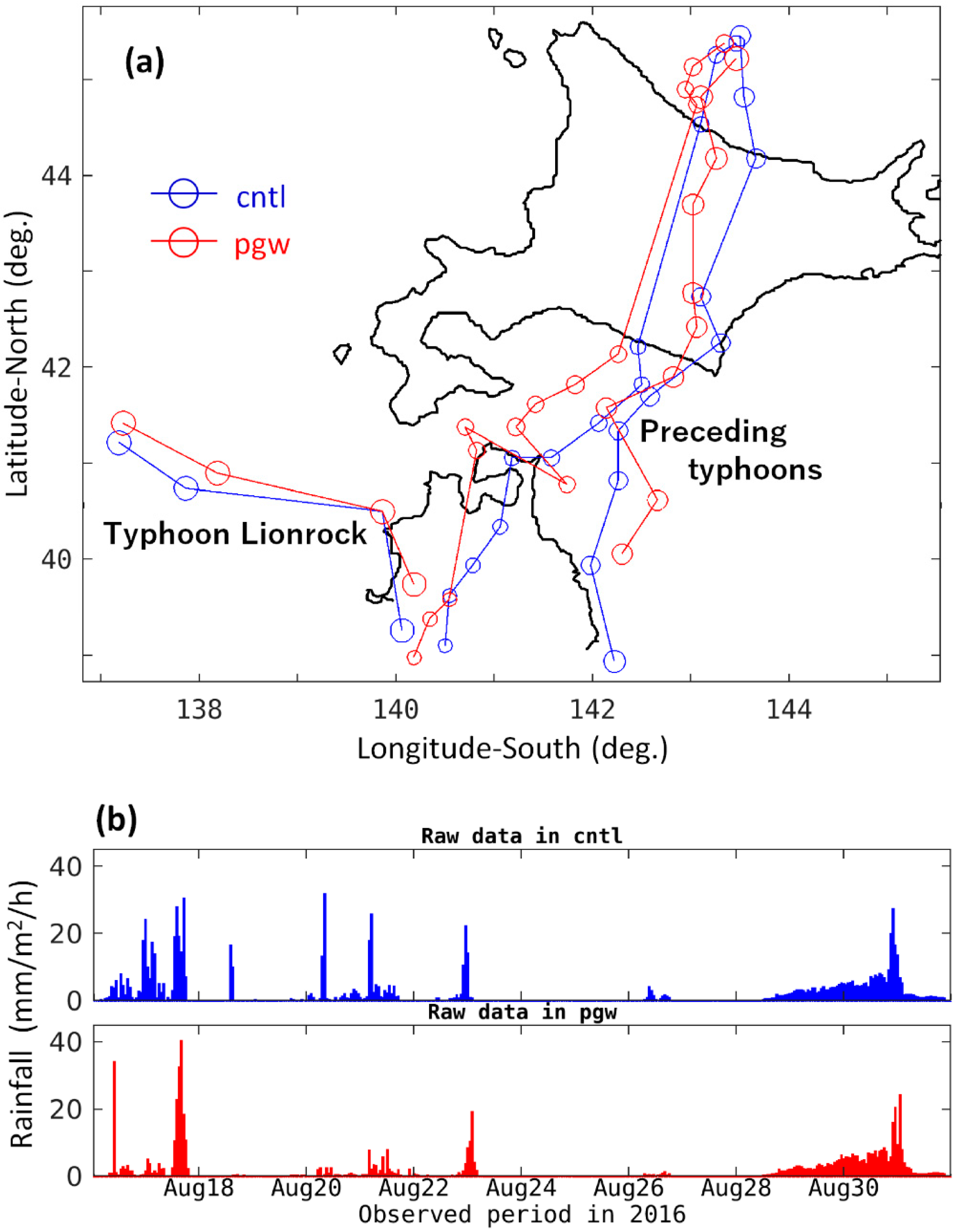
| Asian Typhoon Name | (1) Date and Time of Landing or Approach (2016) | (1) Minimum Central Pressure (hPa) | (1) Maximum Wind Speed (m/s) | (2) Accumulated Precipitation (mm) (Duration) |
|---|---|---|---|---|
| Chanthu | 17 August, 17:00 | 980 | 30 | 197 (48 h) |
| Kompasu | 21 August, 23:00 | 1002 | 18 | 183 (48 h) |
| Mindulle | 23 August, 06:00 | 992 | 25 | 103 (24 h) |
| Lionrock | 30 August, 17:00 | 965 | 35 | 352 (72 h) |
| Dam Name | Location | Catchment Area (km2) | Water Capacity (M–m3) | Length (m) | Height (m) | Surface Area (km2) |
|---|---|---|---|---|---|---|
| Tokachi | 43.240° N, 142.939° E | 592.0 | 112.0 | 443.0 | 84.3 | 4.2 |
| Satsunai River | 42.588° N, 142.923° E | 117.7 | 54.0 | 300.0 | 114.0 | 1.7 |
| # | Station Name | Location | Raw Data | Linear BC | Statistical BC | ||||||
|---|---|---|---|---|---|---|---|---|---|---|---|
| NS | MAE (m3/s) | rMAE (%) (1) | NS | MAE (m3/s) | rMAE (%) (1) | NS | MAE (m3/s) | rMAE (%) (1) | |||
| 1 | Moiwa (main stream) | 42.808° N, 143.512° E | 0.45 | 807.6 | 6.8 | 0.70 | 530.2 | 4.5 | 0.57 | 619.2 | 5.2 |
| 2 | Bisei Bridge (Tributary Bisei River) | 42.923° N, 143.066° E | 0.65 | 36.6 | 3.0 | 0.66 | 44.8 | 3.7 | 0.81 | 36.1 | 2.9 |
| 3 | Totta Bridge (Tributary: Tottabetsu River) | 42.699° N, 143.058° E | 0.70 | 29.1 | 4.1 | 0.75 | 26.5 | 3.7 | 0.83 | 24.6 | 3.4 |
| 4 | Nakajima Bridge (Same above) | 42.733° N, 143.109° E | 0.57 | 30.7 | 3.7 | 0.56 | 43.6 | 5.2 | 0.68 | 34.5 | 4.1 |
| 5 | Rrutanjyoryu (Tributary: Satsunai River) | 42.611° N, 142.870° E | 0.75 | 11.9 | 3.6 | 0.70 | 14.8 | 4.5 | 0.41 | 16.9 | 5.1 |
| 6 | Minami-satsunai (Same above) | 42.603° N, 142.987° E | 0.75 | 27.3 | 3.0 | 0.69 | 24.7 | 2.7 | 0.64 | 30.8 | 3.4 |
| 7 | Dainiohkawa Bridge (Same above) | 42.798° N, 143.157° E | 0.82 | 54.6 | 2.3 | 0.73 | 83.0 | 3.5 | 0.60 | 89.2 | 3.7 |
| 8 | Nantai Bridge (Same above) | 42.8401° N, 43.188° E | 0.73 | 73.5 | 3.0 | 0.72 | 76.7 | 3.1 | 0.90 | 58.0 | 2.4 |
| Product Features in Costs and Profits | Wheat | Beans | Potato | Sugar Beet | ||
|---|---|---|---|---|---|---|
| Soybean | Sweet Red Bean | Kidney Bean | ||||
| Yielding (kg/103 m2) | 632 | 262 | 247.8 | 202 | 3577 | 7100 |
| Unit cost (JPY/kg) | 111.4 | 197.0 | 310.0 | 192.7 | 34.6 | 9.5 |
| Unit gross profit (JPY/103 m2) | 70,424 | 51,614 | 76,818 | 38,919 | 123,736 | 67,308 |
| Average area ratio (%) of each product in the TR watershed | 37.5 | 8.6 | 9.0 | 5.4 | 18.2 | 21.2 |
| Average gross profit of each product (JPY/103 m2) | 26,437 | 4456 | 6932 | 2087 | 22,569 | 14,242 |
| Average gross profit for the major products (JPY/103 m2) | 76,724 | |||||
| Average gross revenue for the major products (M-USD/km2) | 0.72 | |||||
| # | Location Name | Current Flood Simulation | Future Flood Simulation | ||||
|---|---|---|---|---|---|---|---|
| Overflow Volume (M-m3) | Inundated Area (km2) | Damage Cost (M-USD) | Overflow Volume (M-m3) | Inundated Area (km2) | Damage Cost (M-USD) | ||
| 1 | Moiwa | 111.2 | 277.9 | 200.4 | 27.3 | 68.2 | 49.2 |
| 2 | Bisei Bridge | 0.0 | 0.0 | 0.0 | 0.0 | 0.0 | 0.0 |
| 3 | Totta Bridge | 0.0 | 0.0 | 0.0 | 0.0 | 0.0 | 0.0 |
| 4 | Nakajima Bridge | 4.3 | 10.8 | 7.8 | 8.6 | 21.6 | 15.6 |
| 5 | Rrutanjyoryu | 3.9 | 9.7 | 7.0 | 9.1 | 22.8 | 16.5 |
| 6 | Minamisatsunai | 1.2 | 3.1 | 2.2 | 3.8 | 9.5 | 6.8 |
| 7 | Dainiohkawa Bridge | 0.0 | 0.0 | 0.0 | 2.2 | 5.4 | 3.9 |
| 8 | Nantai Bridge | 0.0 | 0.0 | 0.0 | 0.2 | 0.5 | 0.4 |
© 2019 by the authors. Licensee MDPI, Basel, Switzerland. This article is an open access article distributed under the terms and conditions of the Creative Commons Attribution (CC BY) license (http://creativecommons.org/licenses/by/4.0/).
Share and Cite
Kimura, N.; Kiri, H.; Kanada, S.; Kitagawa, I.; Yoshinaga, I.; Aiki, H. Flood Simulations in Mid-Latitude Agricultural Land Using Regional Current and Future Extreme Weathers. Water 2019, 11, 2421. https://doi.org/10.3390/w11112421
Kimura N, Kiri H, Kanada S, Kitagawa I, Yoshinaga I, Aiki H. Flood Simulations in Mid-Latitude Agricultural Land Using Regional Current and Future Extreme Weathers. Water. 2019; 11(11):2421. https://doi.org/10.3390/w11112421
Chicago/Turabian StyleKimura, Nobuaki, Hirohide Kiri, Sachie Kanada, Iwao Kitagawa, Ikuo Yoshinaga, and Hidenori Aiki. 2019. "Flood Simulations in Mid-Latitude Agricultural Land Using Regional Current and Future Extreme Weathers" Water 11, no. 11: 2421. https://doi.org/10.3390/w11112421
APA StyleKimura, N., Kiri, H., Kanada, S., Kitagawa, I., Yoshinaga, I., & Aiki, H. (2019). Flood Simulations in Mid-Latitude Agricultural Land Using Regional Current and Future Extreme Weathers. Water, 11(11), 2421. https://doi.org/10.3390/w11112421