1. Introduction
In intermittent and ephemeral streams (IRES), surface water is absent during certain times of the year. This type of stream drains about half of the world’s land surface [
1]. Phenomena of their drying (timing, frequency, and duration) strongly depend on climate change and anthropogenic actions. They are among the most common and most hydrologically dynamic freshwater ecosystems. Their planetary significance far exceeds the level of our knowledge of them. It should be stressed that streams that periodically cease to flow are not restricted to arid regions. Although IRES make up a high proportion of river networks on Earth, they have been understudied for a long period [
2]. Datry et al. [
3] emphasize: “
After years of obscurity, the science of IRES has bloomed recently and it is being recognized that IRES support a unique and high biodiversity, provide essential ecosystem services and are functionally part of river networks and groundwater systems.”
Intermittent streams do not have continuous flowing water year-round. Intermittence creates unique longitudinal dynamics in flow regimes. Generally, they have flowing water periods during the wet season and are dry during hot summer months. These streams are partially supplied by groundwater rising to the surface as stream baseflow. Intermittent streams dry up periodically as ground water levels decline in drier seasons. Ephemeral streams have less flow than intermittent streams. They are normally dry for most of the year and have flowing water for brief periods in response to intensive rainfall. In the literature, there are many different, more or less similar, definitions and names of IRES, for example [
1]: (1) Ephemeral; (2) episodic; (3) temporary; (4) intermittent; (5) seasonal; (6) dryland; (7) interrupted; (8) nonperennial; (9) near perennial; (10) torrential; (11) influence, etc.
Flow cessation and drying can be caused by one or more of the following processes [
4]: (1) Transmission loss (seepage through porous beds or through small swallow-holes at the karst stream’s bottom), (2) evapotranspiration, (3) downward shifts in water tables caused by natural and/or anthropogenic factors, (4) hillslope runoff recession, (5) freeze-up (cessation of melting or soil freezing), (6) cessation of karst spring discharge, (7) drops in lake level below outlet elevation, and/or (8) cessation of discharge from reservoirs. Flow intermittence is an extreme form of flow variation, which has strong and quick influence on different processes in its catchment, especially ecological.
Specific hydrological, geomorphological, and ecological processes characterize the hydrological regime of any given IRES. Generally, an open stream’s flow regime is characterized by: (1) Magnitude—the total amount of flow at any given time, (2) frequency—how often flow exceeds or is below a given magnitude, (3) duration—how long flow exceeds or is below a given magnitude, (4) predictability—regularity of occurrence of different flow events, and (5) rate of change or flashiness—how quickly flow changes from one magnitude to another. Detailed knowledge of IRES hydrological regimes is a prerequisite to ensure their sustainable development. The most important prerequisite for interdisciplinary analyses of IRES is to understand how alterations in flow regimes impair IRES biodiversity, functions, and services.
After interruption of flow in some IRES, surface waters can be isolated in pools and may continue to flow through the hyporheic zone below the streambed. After some time, this flow may also cease [
5]. One of the main obstacles is that each case is individual, having very different environmental—as well as climatological and hydrological–hydrogeological—characteristics. Considerable work is needed to explain reactions of various ecosystems and/or species to fast and drastic hydrological changes, especially in timing and duration of flow cessation. These investigations are of special importance in the case of analyses of IRES in karst regions, where such changes occur more often than in other geological media. Because of their unique features, the karstic IRES represent especially endangered and vulnerable systems.
Due to very high infiltration rates, overland and surface flows are rare in comparison with non-karst terrains [
6]. Flow regimes in open streamflows in karst depend mostly upon the interaction between the groundwater and the surface water [
7,
8]. They are hydraulically connected through numerous karst forms, which facilitate and govern the exchange of water between the surface and subsurface [
9]. Karst landforms in the analyzed catchment and along the rivercourse play predominant roles in occurrence and duration of flow cessation. Generally, karstic IRES dry up, with the number of zero-discharge days increasing from the spring towards the outlet.
Open streamflow in karst very often disappears underground multiple times and emerges again in different karst springs, usually under a different name. Sinking, losing, and underground streams are frequent karst phenomena [
10]. Bonacci et al. [
11] described a case of one river in Dinaric karst, which, over a length of 106 km, switches among losing, sinking, and underground stream sections eight times. The occurrence of IRES in karst terrain is more the rule than the exception. A losing streamflow is a surface stream that contributes water to the karst groundwater system in localized areas. A sinking surface streamflow can be defined as a surface river or stream flowing onto or over karst that then disappears completely underground through a swallow-hole (ponor or sinkhole), and which may or may not rise again and flow as a resurgent surface river or stream. Infiltration from sinking streams into the karst groundwater system is the most rapid form of recharge for carbonate aquifers [
12]. Underground or subterranean streamflows are subsurface karst passages that have the main characteristics of open rivers or streams.
Karstic IRES cease flowing and dry at certain stream courses, strongly depending on surface and underground karst features and groundwater level oscillations. Rapid and substantial rising and falling of karst groundwater level (more than 100 m in a few hours) is a characteristic which strongly and quickly influences their hydrological characteristics. The lack of techniques to assess the extent and significance of underground conduit networks, caves, and jamas (vertical or subvertical caves), as well as their interconnections with surface karst forms, presents a major problem in analyses, protection, and management of these systems [
13]. Nevertheless, groundwater flow through the rock mass discontinuity networks should not be neglected, especially in regional scale studies, as it often represents a significant portion of the storage—even in karstic areas. To ascertain the vulnerability of water and ecological resources of IRES in karst is much more difficult than in non-karst regions. Karst IRES are among the least-known ecosystems on Earth. Long-term ecological studies and population size estimates in these systems are very rare [
14].
It should be stressed that in all of Earth’s karst regions, there are many IRES. Some cases from Dinaric karst are described in the literature [
11,
15,
16,
17,
18,
19,
20,
21,
22,
23]. IRES are common to all Mediterranean karst areas, whereas the soil is quite thin and the infiltration is relatively high [
15,
16,
17,
18,
19,
20,
21,
22,
23]. For Doglioni et al. [
19], IRES are morphological elements of karstic low-relief areas, characterized by relatively large and flat transects. They occasionally drain runoff, in particular after extraordinary or extreme rainfall events. A karst IRES loses water as it flows downstream, and contributes to the karst groundwater systems in localized areas. These losses can be massive in particular river sections, whereas in others, they are small and difficult or even impossible to observe without performing especially precise measurements [
11]. The main processes causing flow intermittence in karst areas are: (1) Transmission loss; (2) cessation of spring discharge; and (3) groundwater decline. It is also important to mention other environments of similar monitoring and time series were researched [
24,
25,
26,
27].
This paper presents a hydrogeological and hydrological analysis of the intermittent Čikola River and Spring catchment, which are located in deep and developed parts of the Dinaric karst in Croatia. The objective of this paper is to provide a comprehensive explanation of the hydrogeological and hydrological characteristics of one very characteristic intermittent karst river from the Dinaric karst area. The purpose is to improve the general understanding of flow processes within the analyzed intermittent river on the basis of existing data. We hope that this example will be useful for the broader scientific community dealing with complex interdisciplinary problems of karstic IRES.
2. Study Area: Geology, Hydrogeology, Hydrography, and Geomorphology
The study area is located in the central part of the Dinaric karst in Croatia.
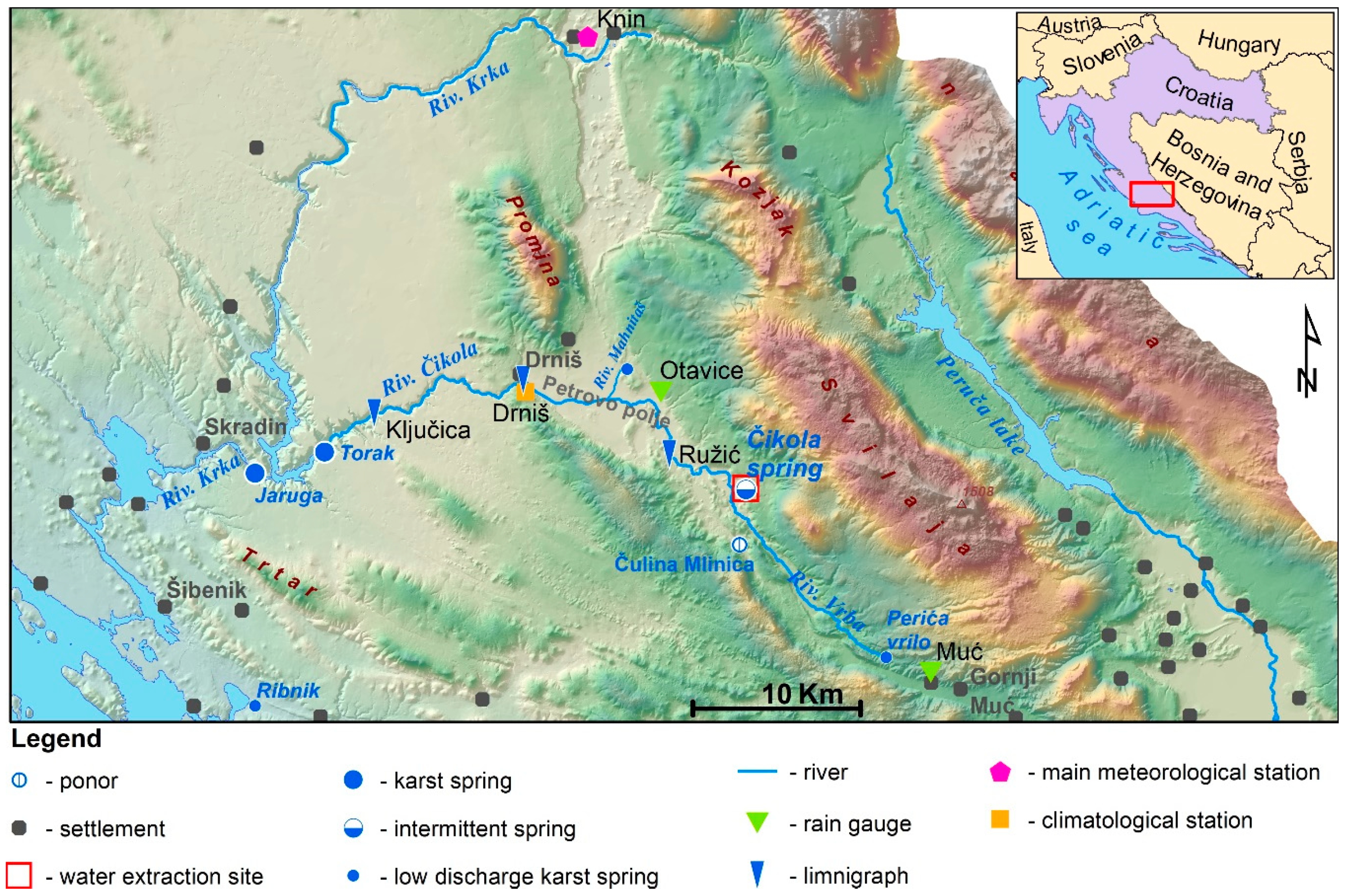
Figure 1 shows a location map of the study area, indicating the Čikola River and Spring, main tributaries (Vrba and Mahnitaš), two temporary springs (Velika and Mala Kanjevača—too close to Čikola to be presented in maps), the permanent spring Torak, three hydrological stations (Ružić, Drniš, Ključice), meteorological station (Drniš), two rain gauging stations (Muć, Otavice), a water pumping site, and some major ponors. The Čikola is a typical karst intermittent river, while its main tributaries, Vrba and Mahnitaš, are ephemeral open streamflows. Mahnitaš is a typical torrential stream. The Čikola River, the largest tributary of the Krka River, emerges in the edge of Petrovo polje under the Svilaja Mtn., runs through the town of Drniš, and drains into the Krka River near Torak. Thanks to its remarkable beauty, the pristine environment of the Čikola River Canyon has been protected since 1965.
Due to well-developed and deep karstification, catchment area boundaries of the Čikola River are not precisely defined. According to the analyses and calculations made by Bonacci et al. [
28], the catchment area of Čikola at Ružić hydrological station covers approximately 300 km
2, and very probably changes in accordance with very fast groundwater level variations.
Dinaric karst is morphologically a typical karst terrain, known for its deep compressive tectonics, especially in the neotectonic phase, which cause intensive reverse faulting, fracturing of rock masses, and, consequentially, deep and very irregular karstification. Such natural conditions practically exclude a groundwater hydraulic modeling approach, especially on a regional scale, and simultaneous hydrological and hydrogeological analysis gives the best results for understanding the stream and its complex connections with the groundwater. Although in certain karst terrains hydraulic modeling is acceptable [
29], for the Dinaric karst regional scale studies, it would be completely senseless. Calculation of the Dinaric karst aquifers hydraulic properties is acceptable only as a rough approximation [
30], in subregional or local scale studies. The investigation of karst aquifers is often limited to the determination of the geological setting, combined with the research of surface water occurrences, as springs, ponors, surface streams, and preferential underground flow paths [
31,
32]. From a hydrogeological point of view, this middle and north Dalmatian karst terrain was researched on a regional scale [
33,
34,
35]. Several studies have addressed similar problems in karst areas (especially Dinaric) [
11,
15,
16,
17,
20,
21,
36,
37]. The data from several unpublished technical reports were used as well.
In most of the Dinaric karst of Croatia, the strike of regional geological structures is NW–SE, the so-called Dinaric strike. Small-scale “Basic geological maps” [
38,
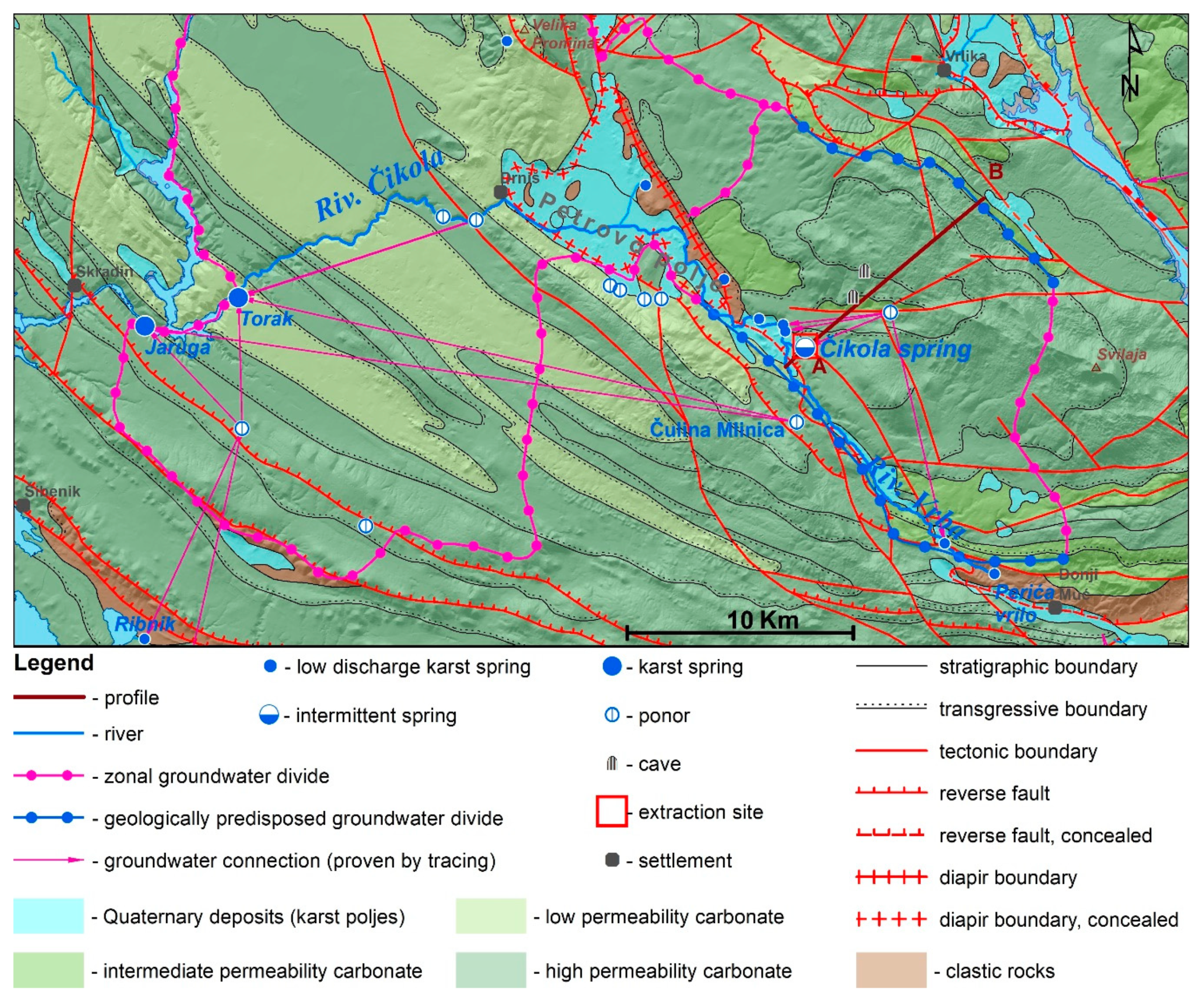
39] cover geological construction of the research area. In the hydrogeological map (
Figure 2), lithological and stratigraphic members were grouped according to their hydrogeological features:
Quaternary deposits—on the surface, mostly alluvial, with intergranular porosity, connected with karst poljes. Permeability depends on clast sizes (usually mixtures of terra rossa clays and silts with clasts of base rocks, mostly carbonates). These deposits are of low relevance for deeper karst groundwater studies, but in Petrovo polje, there is influence on Čikola stream and spring.
Water-tight rock masses—mostly covered by Quaternary deposits of karst in Petrovo polje, various rock types from Permian igneous rocks (diabase), Triassic sandstones, and similar clastites to Pliocene marls and limestone-marls (lake sediments).
Low permeability carbonates—mostly dolomites and dolomitic limestones, which are less karstified. Cretaceous, Jurassic, and Triassic rocks.
Intermediate permeability carbonates—dolomitic limestones and marly limestones, which are tectonically fractured and karstified to a certain extent. Cretaceous, Jurassic, and Triassic rocks;
High permeability carbonates—highly fractured and intensively karstified rocks, mostly from the Upper Cretaceous (rudist limestones) but also most Eocene–Oligocene “Promina” rocks (all except marl beds), and other karstified limestones.
The tectonics of the area is extensive, and the rocks are highly karstified [
40,
41,
42,
43,
44,
45,
46]. Due to compressive tectonics dominated by the reverse faulting of geological structures, karstification reaches deep horizons in the underground and is very irregularly distributed. On the other hand, the Middle Dalmatian plateau where Krka and Čikola canyons were cut is characterized by relatively mild tectonics. The Čikola canyon is up to 130 m deep and is steeply cut, being present in a karst-plateau with low tectonic disturbance, built mostly in Eocene–Oligocene “Promina” or Upper Cretaceous limestone rock mass. Promina is a series of mostly thick (meter-sized) beds of carbonates, conglomerates, and marly limestones. These rocks are mostly subhorizontal and are some of the most important factors in the creation of the recent relief. Because these marly beds are less present, the Promina complex has mostly karstic hydrogeological behavior and resembles neighboring Upper Cretaceous rudist limestones. Carbonates within Promina are calcitic and karstified to about the same extent as neighboring limestones.
According to such spread of lithological composition, most of the terrain is covered by pervious karstified carbonate rocks. In Petrovo polje, under the Quaternary deposits, there are practically impervious clastic (marly) rocks (
Figure 3).
In
Figure 4, there is a detailed cross-section of the Čikola spring zone. The main spring is a cave, speleologically explored several tens of meters. In continuation, there is also a depression with several estavelles (suffosion sinkholes), which are, during high groundwater levels, springs of Čikola. When the spring dries up, these estavelles are either dry or act as ponors—for some shorter period of time, groundwater from alluvial Quaternary sediments of Petrovo polje sinks into the karst underground. As shown, there is an extraction site with four bored wells, which were drilled directly into the cave under the lowest groundwater level and are used for public water supply with a maximal pumping rate of 180 L/s. Extraction from the four close-by wells, out of the same cave which acts as estavelle, and numerous smaller estavelles nearby, makes any attempt of hydraulic modeling impossible, even if the results would be presented within an order of magnitude.
3. Study Area Climate
The climate of the study area is predominantly Mediterranean, with influence of continental and mountain climates at the northern upper part of the catchment. In the Čikola River catchment, there are: (1) A meteorological station, Drniš (1957–2018, missing 1991–1997), and (2) two rain gauging stations, Muć (1991–2018) and Otavice (1998–2018).
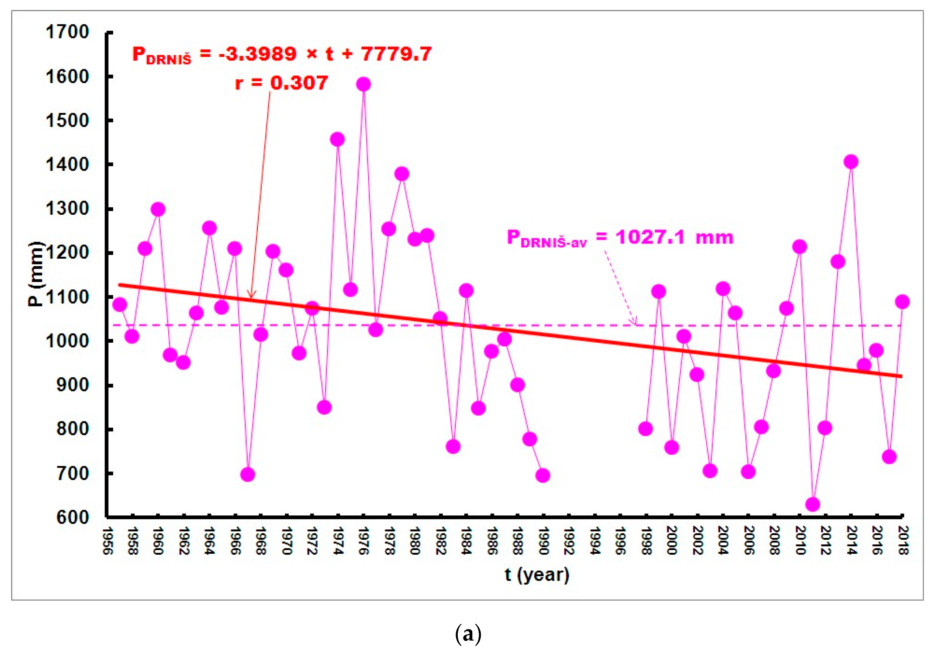
The annual rainfall measured at the meteorological station Drniš in the available period (
Figure 5a) varied within a very large range, between 1581.8 mm (1976) and 630.1 (2011), with an average value of 1027.1 mm. The linear regression line in
Figure 5a shows a decreasing trend. Due to missing data for seven years (1991–1997), there is no utility in testing its statistical significance.
Areal rainfall distribution follows a well-developed morphology. Precipitation events are most abundant at Muć station. Over the 21-year period (1998–2018), when all three rain gauging stations were active, average annual rainfall at Muć was 1261.6 mm, at Otavice 991.1 mm, and at Drniš 951.9 mm. July and August are the driest, while November and December are the wettest months. The rainfalls frequently (few times in the year) reach a greater intensity than 50 mm/h.
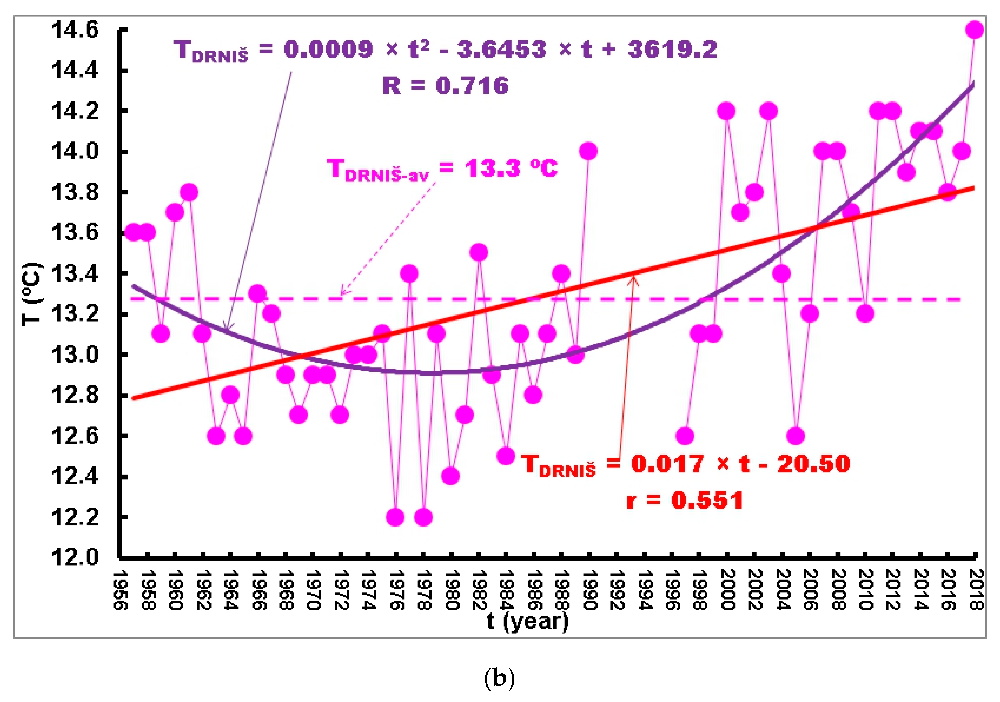
The time series of mean annual air temperatures measured at Drniš meteorological station (1957–2018, missing 1991–1996) depicted in
Figure 5b indicate that air temperatures varied over a broad range, between 12.2 °C (1976 and 1978) and 14.6 °C (2018), with a mean value of 13.3 °C. Linear and second-order polynomial trend lines show existence of an increasing trend, which is very intensive in the recent period of 22 years (1996–2018). If this increasing trend continues, it could have a strong influence on the Čikola hydrological regime, especially in combination with declines in annual rainfall.
Minimum and maximum measured mean daily air temperatures vary between −9.8 °C and 32.9 °C, respectively. Maximum instantaneous temperature can reach 37 °C. The hottest month is July, and the coldest is January [
28].
Previous analyses indicate that in the recent period, annual rainfall has declined, while air temperature has tended to increase. If these patterns continue, water availability and the ecological regime in the intermittent Čikola River and its catchment may be significantly endangered.
4. Čikola Karst River Hydrology
Along the Čikola River’s relatively short watercourse (39 km), there are three hydrological stations (
Table 1). Detailed and reliable hydrological analysis is inhibited by different durations of their discharge time series, as well as by gaps in their operation. Hydrological station Ružić, located 6.6 km from the river spring, has had the longest period of measurement (58 complete years). The other two downstream stations, Drniš and Ključice, have had 32 and 28 complete years, respectively.
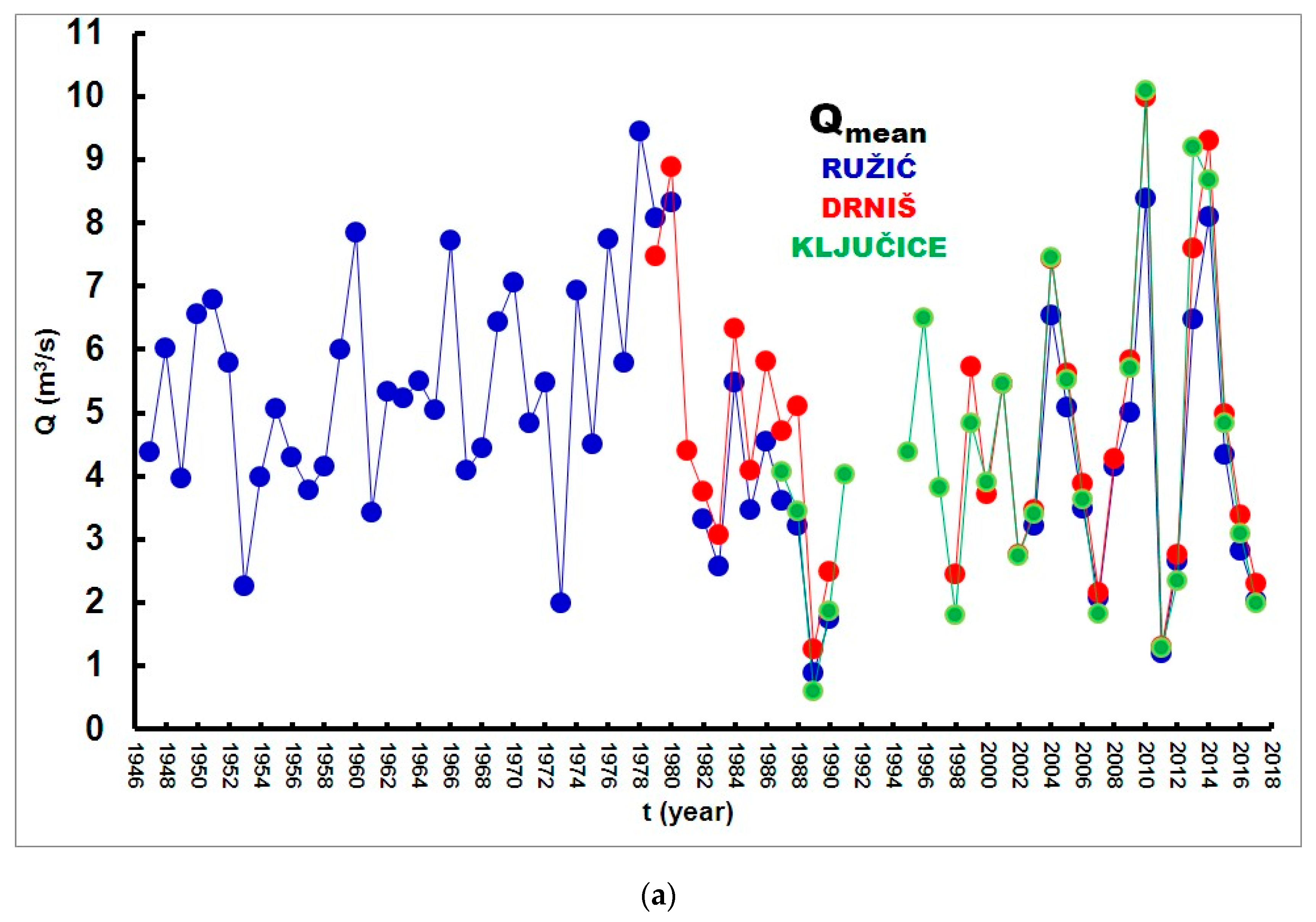
Figure 6a shows three time series of the mean annual discharges, Q
mean (m
3/s), measured at the three hydrological stations along the Čikola River course: (1) Ružić (1947–2017, missing 1981, 1991–2002), (2) Drniš (1979–2017, missing 1991–1997), (3) Ključice (1987–2017, missing 1992–1994 and 2008). The figure shows similar hydrological behavior of mean annual discharges at the three hydrological stations along the river course. Over a period of 15 years (2003–2017, missing 2008), when all three hydrological stations were active, average mean annual discharges were the following: (1) Q
Ružić-mean-av = 4.4 m
3/s, (2) Q
Drniš-mean-av = 5.0 m
3/s, (3) Q
Ključice-mean-av = 4.9 m
3/s. In all cases,
t-tests show no statistically significant differences between average mean annual discharges (see third column in
Table 2).
The situation is different in the case of maximum annual discharges at the three hydrological stations.
Figure 6b shows three time series of the maximum annual discharges, Q
max (m
3/s), measured at the three hydrological stations along the Čikola River course. Over a period of 15 years (2003–2017, missing 2008), when all three hydrological stations were active, average annual discharges were the following: (1) Q
Ružić-max-av = 40.2 m
3/s, (2) Q
Drniš-max-av = 49.4 m
3/s, (3) Q
Ključice-max-av = 53.2 m
3/s. In two cases,
t-tests show no statistically significant differences between average mean annual discharges. The fourth column of
Table 2 presents the results of
t-tests for average maximum annual discharges between the three pairs of hydrological stations along the Čikola River over a period of 15 years (2003–2017, missing 2008), when all three hydrological stations were active. The results of the
t-tests show that Ružić differed significantly (
p < 0.01) from both downstream stations Drniš and Ključice in average maximum annual discharges. The difference between average maximum annual discharges between Drniš and Ključice is not statistically significant.
Although intensive precipitation events are frequent in the Čikola catchment, maximum discharges are not adequately high, which can be explained by the influence of karst features and limited outflow capacity of karst springs [
47].
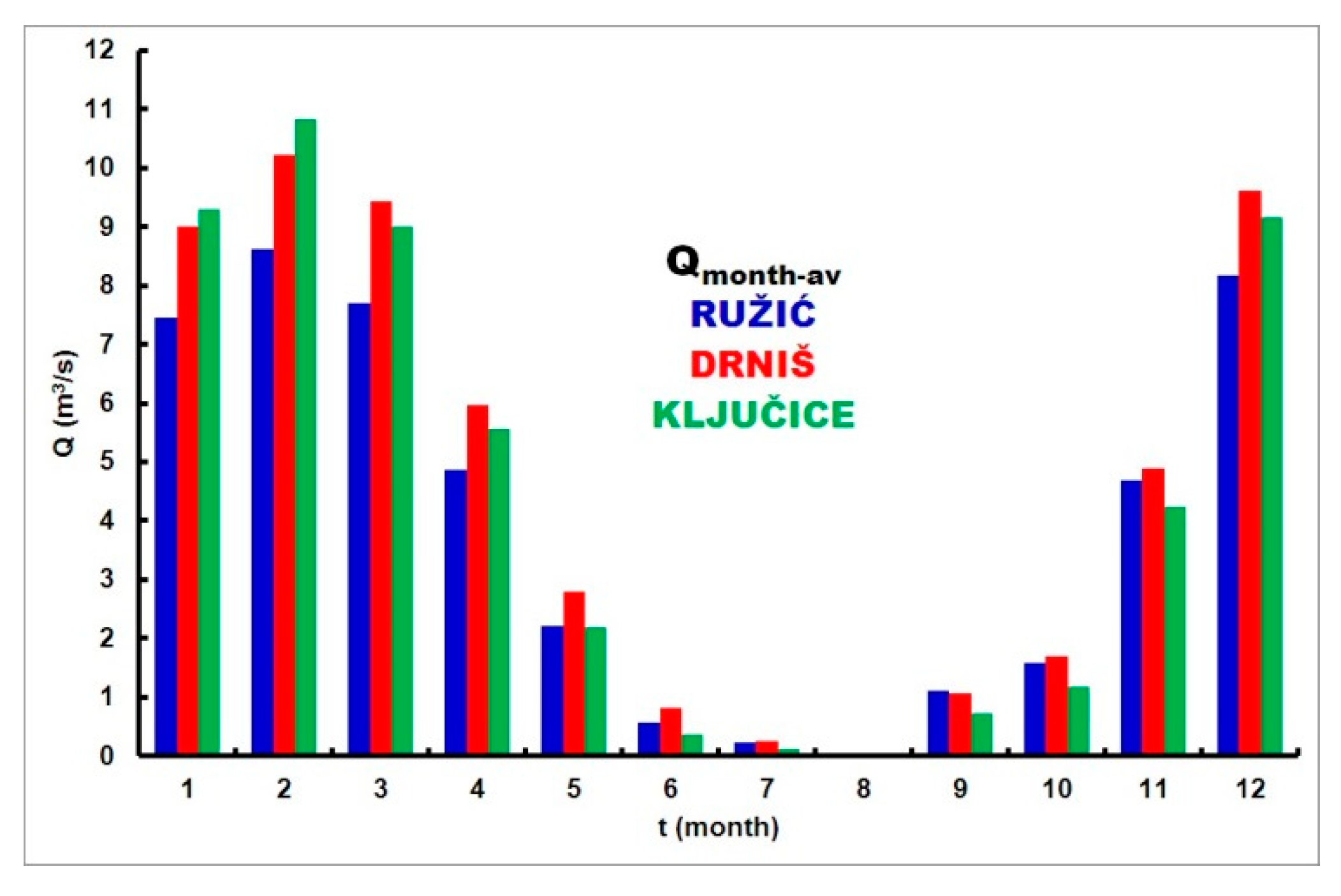
Figure 7 shows average monthly discharges, Q
month-av (m
3/s), measured at the three hydrological stations along the Čikola River course during 18 years in the period 1987–2017 (missing 1991–2002 and 2008). Maximum values of average mean monthly discharges occur in February, and minimum values in August. It is interesting to notice that during January and February, the average mean monthly discharges in Ključice are higher than at the two upstream stations, Ružić and Drniš, indicating that when groundwater levels are high, the karstic catchment of the canyon drains groundwater directly into the stream. In March, April, and December, average mean monthly discharges at Ključice are higher than at Ružić, but lower than at Drniš. In every other month from May to November, average mean monthly discharges at Ključice are lower than at the two upstream stations—river water sinks into the karst rock mass, mostly reappearing at the Torak spring in its estuary.
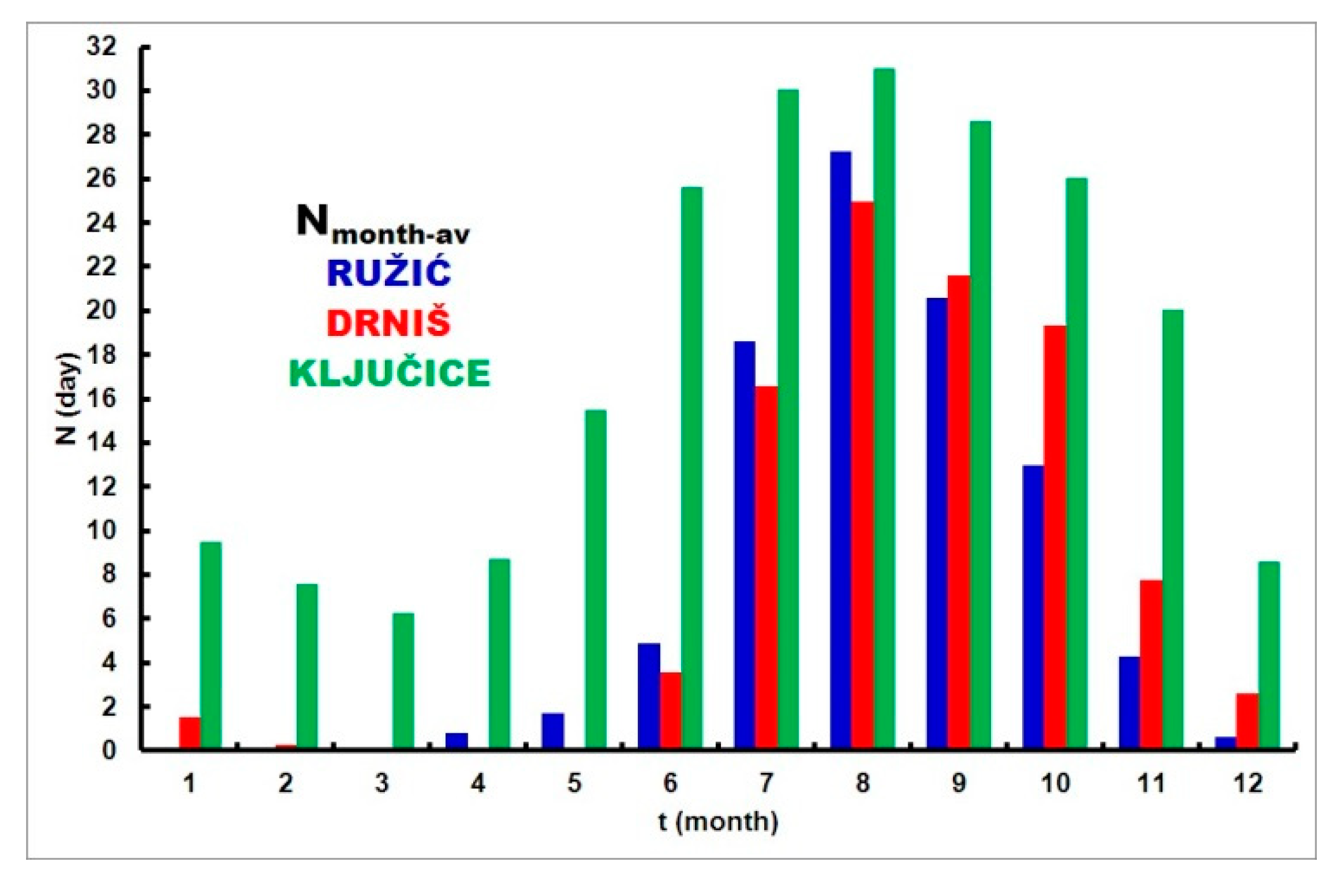
At Ružić hydrological station (1947–2017, missing 1981, 1991–2002), the number of dry days per year, N, varied over a broad range between N = 0 (1947, 1948, 1951, 1957, 1959, 1963, 1966, 1968, 1969, 1972, 1978, 1979, 1980, 1982, 1984) and N = 184 (2003), with an average value of N = 56.3. At Drniš hydrological station (1979–2017, missing 1991–1997), the number of dry days per year, N, varied over a broad range between N = 0 (1983, 1984, 1986, 1989, 1999) and N = 178 (2006), with an average value of N = 75.9. At Ključice hydrological station (1987–2017, missing 1992–1994 and 2008), the number of dry days per year, N, varied over a broad range between N = 93 (2014) and N = 317 (1989), with an average value of N = 211.9 [
28].
Figure 8 shows average number of dry days, N
month-av (day), during the months monitored at the three hydrological stations along the Čikola River course over 18 years in the period 1987–2017 (missing 1991–2002, 2008). At Ružić station, drying never occurred in January, February, or March. At Drniš station, drying never occurred in March, April, or May. At the most downstream station, Ključice, flow cessation occurred every month.
5. Relationship between Groundwater and Surface Water
The entrance into the Čikola spring cave is situated at ca. 279 m a.s.l. When groundwater starts to appear at the surface, it slowly fills the depression with estavelles (
Figure 3), which start to act as springs as well. At the end of this spring zone is a weir (low dam), and when water starts to spill over it significantly, the river starts to flow. This happens at the elevation of 285 m a.s.l. After that, the small increase in groundwater level in the Čikola spring results in significant increase of discharge at the Ružić hydrological station (
Figure 9), and after that, at Drniš and Ključice stations as well. After the point when the Čikola spring zone starts to spring over the weir, all water quantities from Vrba and other smaller springs in the area become negligible.
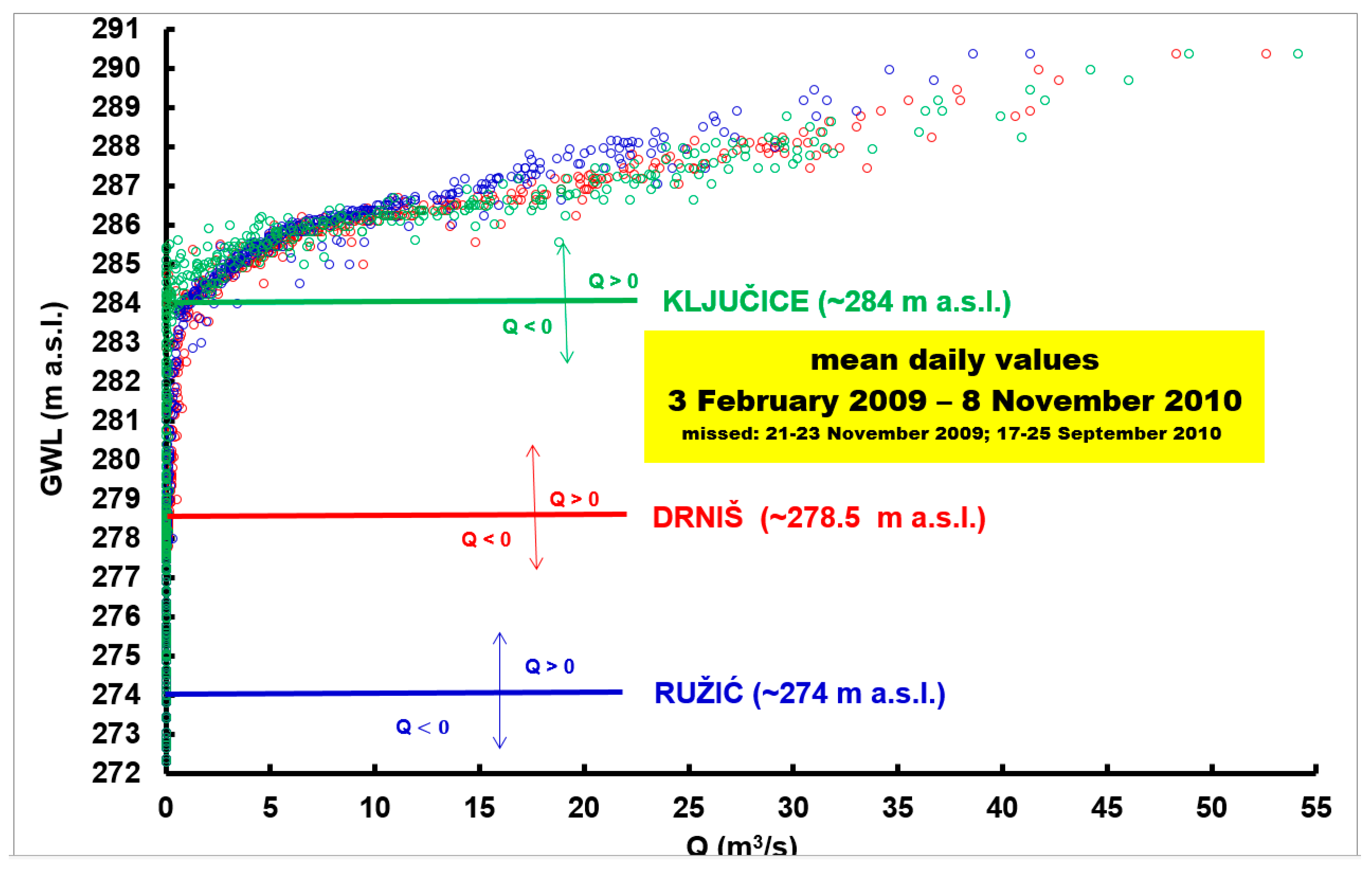
Over the period 3 February 2009–8 November 2010 (645 days), continuous measurement of groundwater level (GWL) was performed at one of the extraction wells drilled in the Čikola spring/cave (
Figure 4). During that period, the minimum GWL was 266.91 m a.s.l. and the maximum value was 290.38 m a.s.l. The relationship between the mean daily groundwater level, GWL (m a.s.l.), and the mean daily discharge, Q (m
3/s), measured at Ružić (dark blue color), Drniš (red color), and Ključice (green color) hydrological stations during that period is presented in
Figure 9. Emergence of surface flow at Ružić hydrological station occurs when GWL at the extraction site exceeds ~274 m a.s.l. At the two downstream hydrological stations, Drniš and Ključice, surface flow occurs when GWL exceeds ~278.5 and ~284 m a.s.l., respectively (
Table 1). Groundwater pumping quantity is similar every day (working only a few hours during the night with quantities below 180 L/s), and its influence on groundwater levels proves to be very low, especially with minimal GWL, and therefore can be neglected. Although the Čikola spring starts to discharge groundwater from the cave at some 279 m a.s.l., the real discharge starts when spring-zone water exceeds the top of a small weir—ca. 285 m a.s.l. River flow measured at all three stations below that level at spring is quite low (
Figure 9), especially at the Ključice station. Since the other two stations (Ružić and Drniš) are situated outside of the karstic areas, in Petrovo polje Quaternary sediments that overlay impervious rock masses, it can be presumed that water in the Čikola River during such periods (levels at extraction site between 274 and 285 m a.s.l.) is connected with smaller tributaries, such as Vrba, and groundwater from the alluvial sediment of the polje itself. As the measured discharge in the riverbed in such terms rarely exceeds a few cubic meters per second, the data are probably associated with heavy rains in the polje and/or rapid drops in water level during the beginning of the recession period.
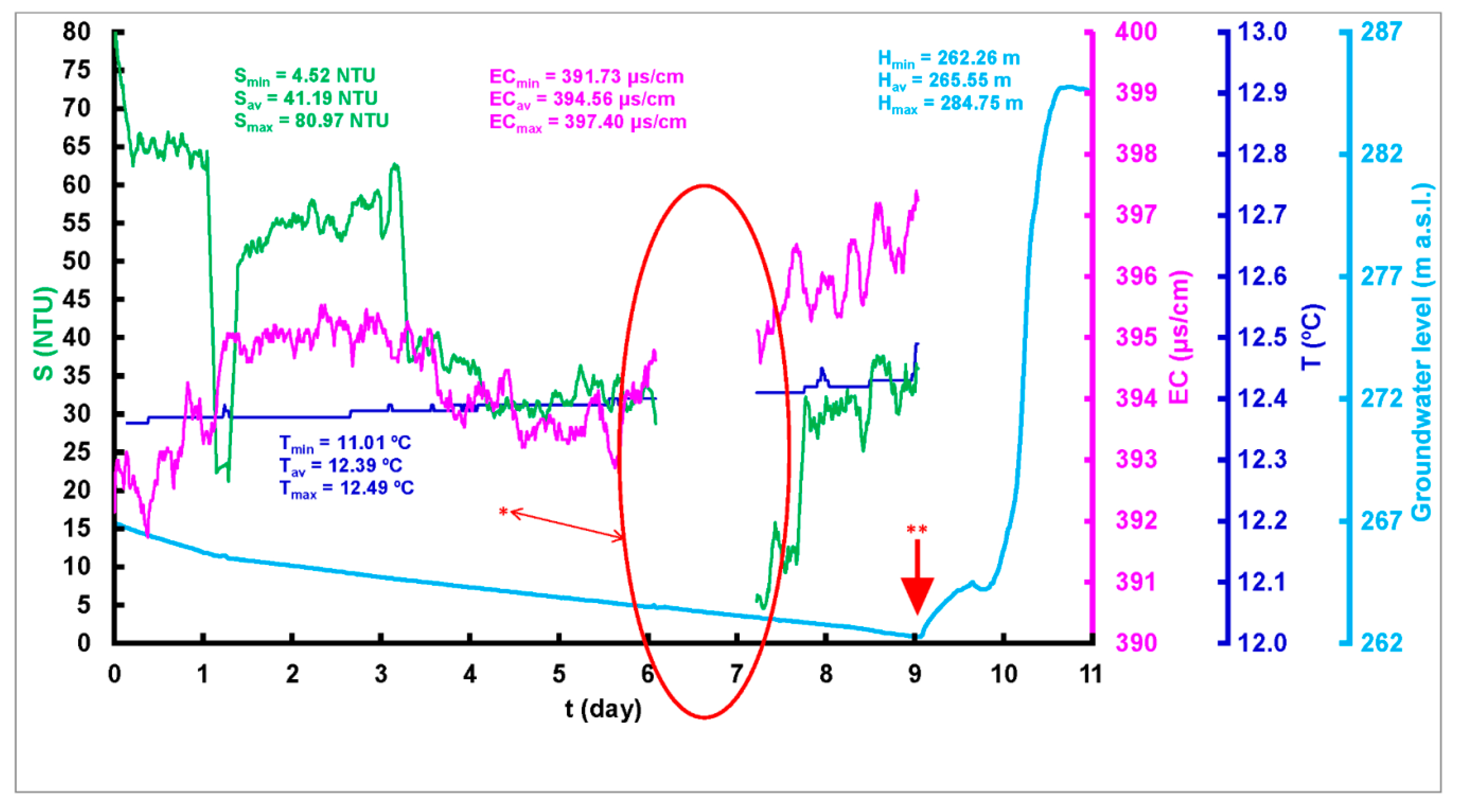
Three time series of turbidity S (NTU), groundwater temperature T (°C), and electrical conductivity EC (μS/cm) were measured using a datalogger (fluorimeter) GGUN-FL during one of the two pumping tests (the second pumping test was shorter and is not presented here) that were done on the Čikola spring (extraction wells) (
Figure 10). Turbidity ranged from S
min = 4.53 NTU to S
max = 80.97 NTU, electrical conductivity from EC
min = 391 μS/cm to EC
max = 397 μS/cm, and groundwater temperature from T
min = 11.01 °C to T
max = 12.49 °C. The changes in EC and groundwater temperature during the pumping test were rather low, and values are typical for karst groundwater in that area. Variations in turbidity were associated with the turbulent start of the pumping test, but after less than a day, they became very low (up to six NTU) and steady.
The pumping test was conducted using maximal pumping quantity in all four wells, 180 L/s, without disruption (except marked period,
Figure 10). The test started during very low GWL, ca. 267 m a.s.l., at the end of a long dry period—the riverbed was completely dry. In the first few days, GWL declined with an almost linear trend, but very slightly. On 25 September, rain started in the spring’s catchment, and in less than one day, pumping became negligible, GWL rose significantly (over 20 m during one day), and the river started to flow. Of course, the pumping test was stopped. During both pumping tests, groundwater temperature was equivalent to the average air temperature in the catchment area, ca. 11–12.5 °C, while EC values approximately 395 μS/cm were typical for Dinaric karst groundwater. EC increases with increasing water hardness [
32,
48]. The karst groundwater conductivity measured at several karst springs in France ranged between 220 and 470 μS/cm, with a mode of 380 μS/cm. During the pumping test, total drawdown was approximately 5 m, followed by a slight increase in the EC value and T. After the first heavy rain in the catchment area, the spring reacted quickly.
One of the most challenging issues when researching karst systems on a regional scale is the positioning of water divides, i.e., delineation of catchment areas. Probably the most powerful tool for this delineation is a groundwater tracing experiment (see connections proven by tracing in
Figure 2). The catchment delineation in such karst systems is especially difficult in intermittent systems, when a spring or river dries out. The catchment area is strongly associated with geological construction, and the influence of topography is minor. As mentioned, the hydrologically determined catchment area of the Čikola River at Ružić station is approximately 300 km
2, while, for the previously described geological reasons, it cannot exceed 250 km
2. The absence of hydrological stations in higher karst areas of Svilaja Mtn. is probably the reason. It is also important to point out that in significant parts of the Dinaric karst, divides are so-called zonal divides, meaning they change position according to hydrological conditions, groundwater levels. Strong karst springs of neighboring catchments preclude the possibility of increasing the Čikola spring catchment area; only common use of hydrological and hydrogeological approaches can lead to increase in knowledge and improvement in the positioning of groundwater divides (they cannot practically be connected with topography). The groundwater divide in the karst plateau between the Krka and Čikola rivers is probably closer to Čikola, but it changes position significantly according to hydrological conditions (unfortunately, there are no observed GWL data in Svilaja Mtn., nor in mentioned karst plateau; no monitoring boreholes at all). All of this area is usually considered to be a catchment of the Torak spring, but during high GWL, it strongly influences Čikola, as is recorded at the Ključice hydrological station (
Figure 6).
Krka canyon is deeper (up to 200 m) than the Čikola canyon (up to 130 m). Both canyons were cut in the same geological structure, mostly Eocene Promina carbonate clastites and Cretaceous carbonates, which are both intensively karstified. Krka’s stream is permanent and much stronger, due to stronger contributories and a much bigger catchment area, while Čikola flows at higher altitude and that is the main reason for more emphasized sinking within its own riverbed after entering karst terrain (canyon), except during periods of very high GWL.
In karst terrains, groundwater and surface water constitute a single dynamic system. Determination of the catchment area and boundaries in karst environment presents an extremely difficult and complex task, which very often remains unsolved. A karst basin represents a complex system of water circulation governed by numerous extremely different surfaces and underground karst forms. Locations, dimensions, and spreading of underground karst phenomena are generally unknown. In such heterogeneous and anisotropic systems, water may circulate in unexpected directions, mainly depending on groundwater level. The interdependency between surface water and groundwater in karst occasionally or permanently changes in time and space. These changes are caused by natural processes, as well as anthropogenic interventions, which have been very intensive in the last hundred years or so and are generally uncontrolled. Due to previous briefly specified reasons, the discovery, explanation, and quantification of water circulation in karst media is not an easy task, and in some cases is even impossible.
6. Conclusions
In the case of an intermittent karst river, the specificity of the karst geological setting strongly influences complex interrelationships between the surface stream and groundwater. Detailed hydrogeological and hydrological monitoring and investigations can help elucidate and better explain these processes. The example of the Čikola River provides good evidence of this fact. An exclusively hydrogeological or exclusively hydrological approach would not be adequate for interpretation, as presented. Further improvements can be accomplished with more detailed monitoring of both river and groundwater, which would include continuous measurements of levels and physical–chemical characteristics, especially during storm events and the end of recession. Delineation of catchments and subcatchments can only be achieved with several iterations among hydrogeologists and hydrologists. Due to ongoing climate changes/variations, the monitoring must be more detailed, considering both spatial and temporal distribution, and must cover hydrological, hydrogeological, and ecological processes in the analyzed area. Previous analyses have revealed strong and dangerous increasing trends of air temperature and decreasing trends of precipitation over the last 20 years. This paper shows that only a multi-methodical approach is possible in terrains as such, where hydraulic modeling is not an option. Nevertheless, within further research, a thorough program of hydrochemical, isotopic, and geophysical methods should be included to achieve better understanding of the system.
To better understand and manage IRES of crucial importance is to bring together hydrologists, hydrogeologists, biogeochemists, ecologists, modelers, environmental economists, social researchers, and stakeholders to form a research network for synthesizing the fragmented, recent knowledge on IRES, improving our understanding of IRES and translating this into science-based, sustainable management of river networks. Drying affects flow continuity through time and flow connectivity across longitudinal, lateral, and vertical dimensions of space.
The conclusions of the presented Čikola River and Spring research are comprised of several points: (1) The spring (cave) has limited discharge capacity, and after it reaches its maximal rate, several supplemental springs occur in the vicinity; (2) the reaction of the spring on rainfall in hinterland is rapid and abundant; (3) the river flows in three different environments—through the karst polje, through the canyon, and in estuary; (4) groundwater and surface water are interrelated; and (5) after appearing in polje, the discharges have to increase (
Figure 10) to provide enough water for the river to flow through the canyon.
There are multiple areas in which a lack of knowledge hampers the effective management of intermittent streams [
49]: (1) Hydrologic processes, (2) the effects of flow stress on ecological processes, (3) restoring degraded IRES, and (4) assessment of the condition of IRES. For both hydrology and ecology, there is a paucity of detailed scientific data on IRES, especially these located in karst regions. Traditional flow-gauging systems have vastly underestimated the number of rivers and streams flowing intermittently [
3]. Unfortunately, for more detailed and more reliable conclusions, the analyzed case requires measures from more hydrological stations and a dense network of piezometers drilled in karst aquifer (and Petrovo karst polje as well) along the Čikola River watercourse, as well as precipitation measuring gauges within the catchment areas. Despite this obvious shortage, the example discussed in this paper is very characteristic for practically all IRES in karst terrains and can usefully help other colleagues dealing with the analyses of karstic IRES.
Larned et al. [
4] and Boulton [
50] suggested six primary objectives for IRES conservation: (1) Preservation or restoration of their aquatic–terrestrial habitat mosaics, (2) preservation or restoration of their natural intermittency, (3) identification of flow requirements for highly valued species and processes, (4) adoption of conservation measures that explicitly acknowledge the importance of the spatial arrangement of ephemeral streams to the entire drainage network, (5) protection of the contributions of ephemeral streams to local and regional aquifer recharge and water quality, and (6) recognition of the cumulative importance of the brief periods of flow to aquatic and terrestrial ecological processes.
Climate change may exert a strong effect on any IRES, and particularly on the Čikola River. Intensification of global warming will cause earlier initiation or later completion of flow cessation. Additionally, water pumping can influence extension of drying duration. A definite conclusion is that water and ecological resources in this vulnerable karst catchment are under stress. These effects are presently difficult to predict.
It is realistic to expect that the occurrence of spring and river drying in the nearby future will be much more frequent and severe. As a result, conflicts between water supplies and the environment will very likely be stronger and with more dangerous consequences. To help mitigate negative consequences, Dragoni et al. [
51] insist on a better understanding of complex interrelations between surface water and groundwater, as well as the influence of future anthropogenic actions. We hope that this paper can help in achieving better results in understanding and management of the extraordinarily valuable and complex systems of karstic IRES.


