(2) Pre-define the runoff coefficient
Except for the rainwater lost in the process of stratum infiltration, vegetation interception, and surface land evapotranspiration, most of the rainwater will be surface runoff, which will need to be discharged into the water system. The hydrology model integrating the runoff coefficient method is widely adopted for rainwater calculating. The runoff coefficient is related to the local terrain and hydrology features, and it needs to be calibrated by many rainstorm and runoff observation experiments. Therefore, we suggest to adopt the official provided runoff coefficient values.
The comprehensive runoff coefficient used in urban areas is usually between 0.5 and 0.8, and its range is (0.4, 0.6) in the suburbs [
39]. Referring to the official definition from the Wuhan Municipal Flood Control and Drainage Regulations (version year 2013) [
40], it was calculated for the VIS-W model. Compared to the VIS-W model, the type of vegetation (V) has a direct corresponding value, and we adopted 0.275, which is the average value of the proposed values. The type of imperious surface (I) adopts the average value of the corresponding resident land, business land, industry land, and traffic land, and its value is 0.775. The type of soil (S) adopts the corresponding value of the other land, and the value is 0.275. Furthermore, the type of water (W) always represents the area for storing rainwater. Therefore, its value shall be considered as 1, which means that all of the rainwater produced in the range of the water area will be collected completely by the water storage system. All of the final values we adopted in this paper are listed in
Table 3.
The quantity of runoff rainwater needs to be calculated by the rainfall–runoff hydrology model. We used the integrated runoff coefficient related to the underlying surface model to obtain the value. The area of land type in VIS-W was considered as the weight to obtain the integrated runoff coefficient, as shown in Equation (6).
where
Ψint represents the integrated runoff coefficient, which is the average of the runoff coefficient weight by the area ratio of land cover type in the VIS-W model, including the land cover types of vegetation, impervious surface, soil, and water;
Ai (unit: 10
4 m
2) represents the area of land type in the sub-catchment; and
ψi represents the runoff coefficient of land use types in the VIS-W model, including vegetation, impervious surface, soil, and water.
(3) Pre-define the rainfall precipitation
The precipitation is the main input when calculating rainwater. In a city, the statistical precipitation according to the hydrological frequency analysis can reflect the city’s common rainfall intensity. In China, the city’s frequency adjustment of design storm intensity usually adopts an empirical frequency distribution curve model, such as the extreme value distribution curve, the negative exponential distribution curve, and the Pearson-Ⅲ type distribution curve [
39]. In this paper, we quoted Wuhan’s design rainfall identity (the precipitation of four return periods: 1, 5, 20, and 100 years) proposed by Guoping Hong et al., based on the theory of the extreme value distribution curve [
41], and the values are listed in
Table 4.
In order to qualitatively estimate the rainwater capacity of each sub-watershed, the four designed precipitation values are divided into six intervals, which can be described as interval set :{“<1”, “1–5”, “5–20”, “20–100”, “~100” and “>100”} as shown in
Table 5. The middle four intervals are calculated by the mean value of the two neighboring sides of precipitation; the first interval “<1” has the minimum value of “1–5”, and the last interval “>100” has a maximum value of “~100”.
where
can utilize 6-h or 12-h duration precipitation to calculate the return period interval. Its interval values can be quantified by the interpolation of precipitation according to the previous four return periods.
represents the return period interval and its precipitation, which uses the duration of 6 hours as the basic calculating value.
represents the return period interval precipitation and is based on 12 hours of precipitation. The interval value “<1” adopts the value of 1-year precipitation as the maximum.
The interval values “1–5”, “5–20”, and “20–100” use the left neighbor’s maximum as the minimum, and adopt the average value of the two interval sides corresponding to precipitation as the maximum. The fifth interval “~100” uses the maximum of the previous neighbor interval “20–100” as the minimum, and the value of the 100-year return period is accumulated as the average value of the precipitation values of the 20-year and 100-year intervals. The sixth interval ">100" adopts the maximum value of the interval “~100” as the minimum limitation.
(4) Construct basic maps
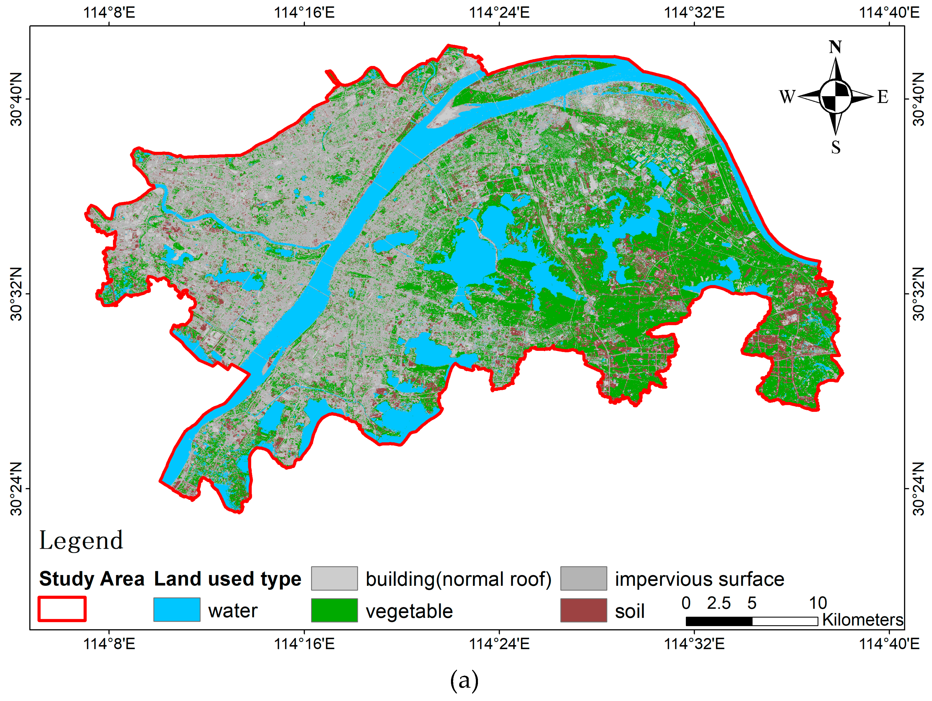
We mainly need to map the slope, land-use type, and the watershed, as shown in
Figure 3. With the exception of the land-use type, which is extracted by ENVI 5.3, the other maps are produced using the related tools in ARCGIS 10.2.
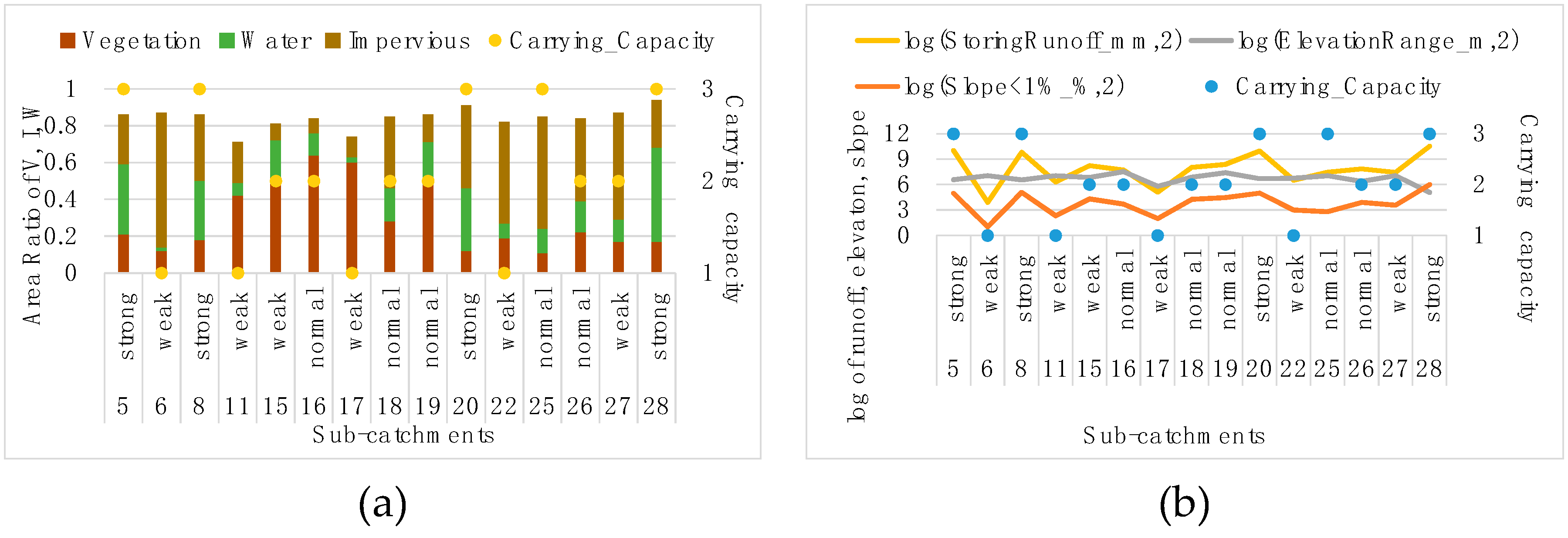
1) Land-use type. The ratio of land cover type is used to calculate the rainfall–runoff production based on the urban runoff coefficient in each sub-watershed. The land cover type is composed of the vegetation, impervious surface, soil, and water, based on the VIS-W model. The maximum likelihood method was used to extract the land cover type by ENVI 5.3 from the GF-1 and GF-2 images. We firstly extracted the vegetation, impervious surface, soil, water, and shadow. Then, according to the spatial adjacency between the shadow and the water, we could identify the part of shadow which should belong to water, and we regarded the left part of shadows as the impervious surface. This might bring a slight overestimation of the impervious surface, but we considered this as acceptable because the rainwater produced by the overestimated impervious surface is too small to disturb the collected water.
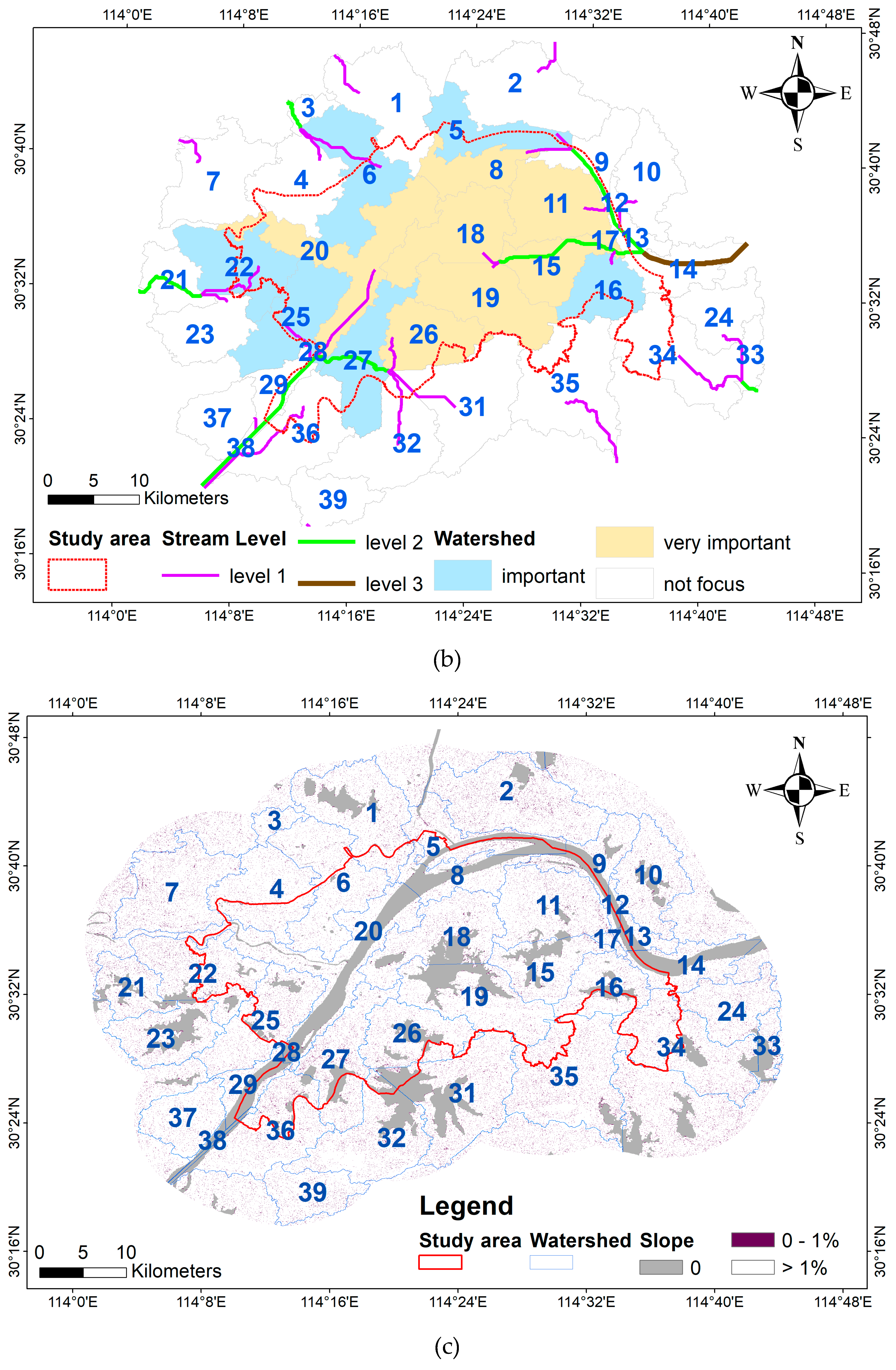
2) Watershed. The watershed polygon is the defined basic evaluation unit. We used the hydrology tool of ARCGIS 10.2, which is based on the D8 algorithm, to delimitate watershed. Related to the previous research, we used a refined DEM by water body for watershed delimitation, since the performances will increase the certainty of flow direction and improve the accuracy of the delimited watershed compared to the original DEM [
42]. The adopted water body was extracted from GF-1 and GF-2 by the previous land type map step. Based on the smallest area of the Sanjiaohu lake watershed [
43], we used 11,111 (10 km
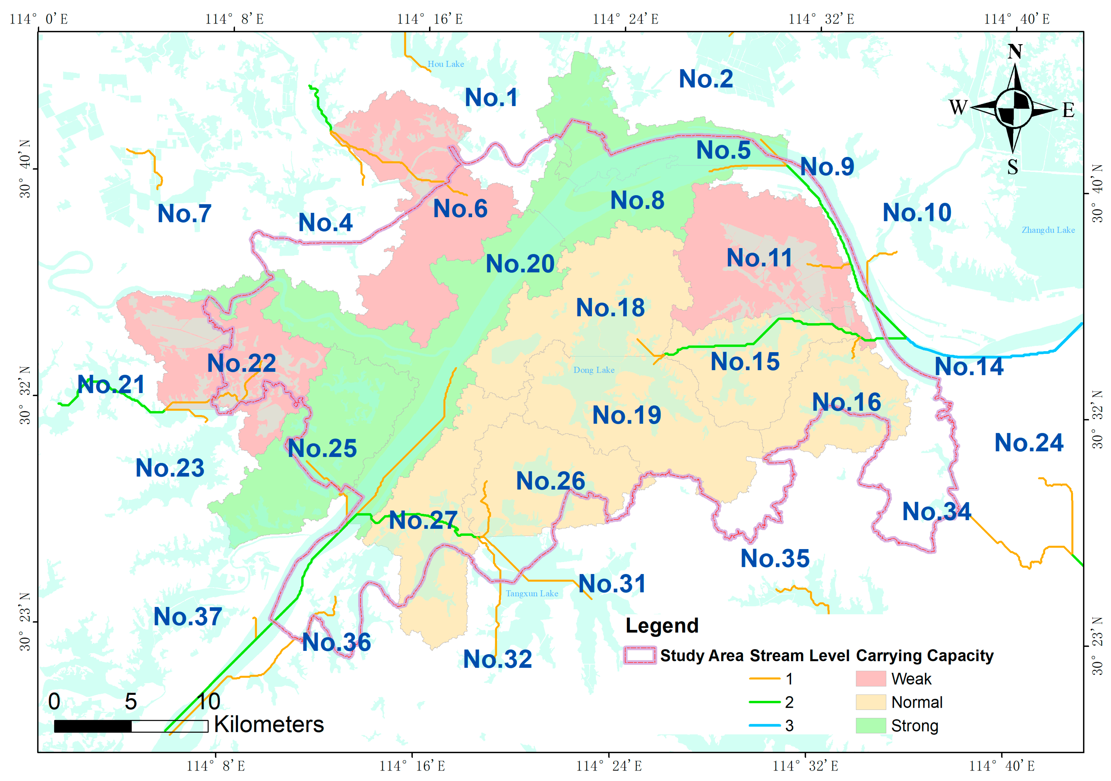
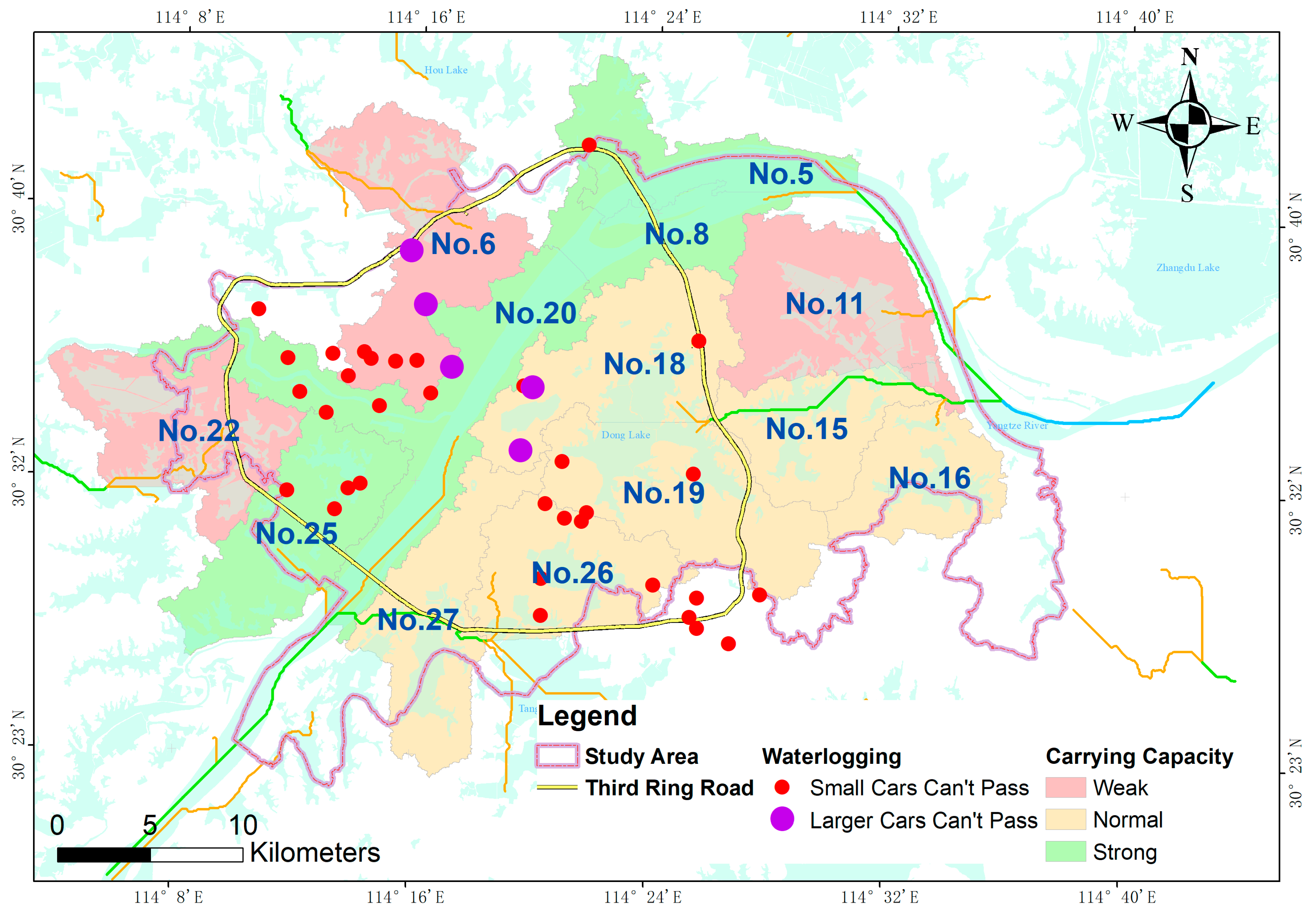
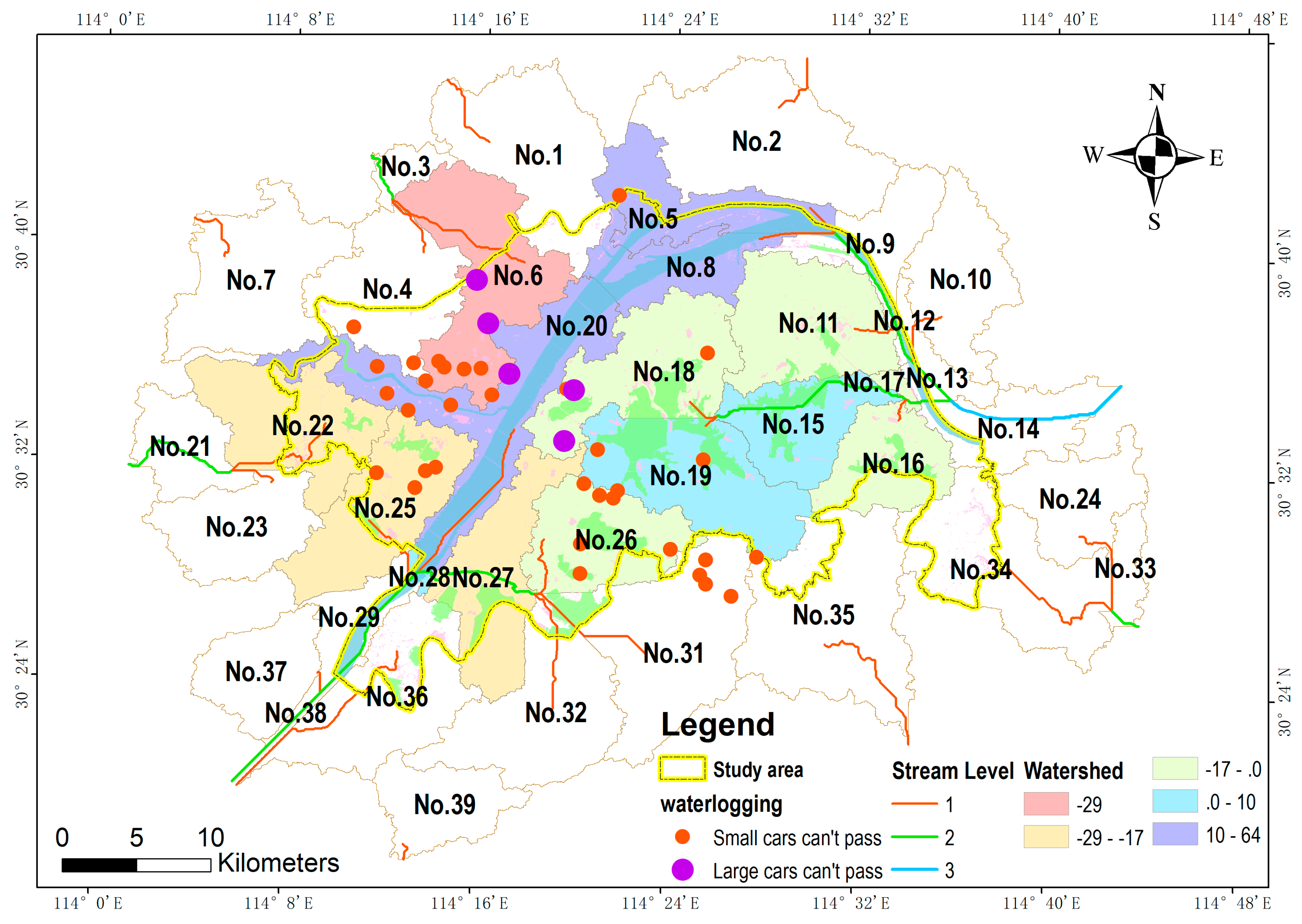
2/ 30 m × 30 m ≈ 11,111) as the limitation of flow accumulation to extract the stream network, and we got 38 sub-catchments, finally. Considering the condition that the inside area ratio must be higher than 40%, there are 15 sub-catchments that have been chosen. They are divided into two groups: the “very important” group, for which the ratio is more than 89% (including No. 8, No. 11, No. 15, No. 17, No. 18, No. 19, No. 20, and No. 26), and the “important” group, for which the ratio is between 40% and 89% (including No. 5, No. 6, No. 16, No. 22, No. 25, No. 27, and No. 28).
3) Slope < 1%. The slope < 1% raster map is used to identify the low-lying area, and it will be used to analyze the areas which need to pump outside of the watershed. It is calculated by the DEM data set using the slope analysis tool and the raster calculation tool in ARCGIS 10.2.
(5) Construct basic indicators
(1)
. Corresponding precipitation in each sub-catchment is used to express the storage capacity. It is composed of three parts: the river, the lake, and the puddle or pond.
where
(unit: m
3) represents the rainwater storage, and the storage volume of the river, lake, and puddle or pond are represented by the
(unit: m
3),
(unit: m
3), and
(unit: m
3), respectively.
● River storage
The potential storage of a river is determined by the limitation of the water level in flood seasons. In this paper, we take three meters as the water level increase limitation based on the flood control water level of the Yangtze River and Han River. Equation (9) is used to calculate this storage capacity:
where
y (its unit is 10
6 m
3) represents the storage capacity of the river area in the sub-catchment,
Ai (unit 10
6 m
3) is the area of water belonging to the river,
ρ represents the area coefficient of the calculated river, and
h (unit is m) is the storing water depth. We default set the following:
ρ = 1.0 and
h = 3.0.
● Lake storage
Zhou et al. [
43] proposed the identification of the storage of lakes in terms of pre-regular pumping (the water level should be 0.3 m, and the area coefficient should be 0.8), normal storage (the water level should be 1 m, and the area coefficient should be 1), and extended water level (the water level should be 0.3 m, and the area coefficient should be 1.2).
Here, (unit: 106 m3) represents the capacity of lake storage, (unit: 106 m3) represents the storage of a normal storage capacity, (unit: 106 m3) represents the volume of the pre-regular pumping water level before flood seasons, and (unit: 106 m3) represents the magnifying storage according to the surveyed average flood control water level. Ai (unit: 106 m2) represents the area of lakes in the sub-catchment, ρ represents the calculating area coefficient of lakes, and h (unit: m) represents the permission increasing water level in lakes. We default set ρ = 1.0 and h = 1.0 to calculate the normal storage, set ρ = 0.8 and h = 0.3 to calculate the pre-pumping storage, and set ρ = 1.2 and h = 0.3 to calculate the lakes’ expansion storage.
● Puddle or pond storage
Puddles or ponds can temporarily store rainwater in residential areas. In this study, we defined single areas of water bodies measuring between 900 square meters and 100,000 square meters as puddle or pond entities. This is because 900 square meters represents an area of about the horizon resolution of DEM (length 30 meters, and width 30 meters). Additionally, the area of 100,000 square meters is close to the area of Sanjiao Lake, which is the smallest lake in Wuhan. The distribution of pits or ponds is wide and relatively separate. We found the location of pits or ponds to be generally near residents, which demonstrated that there is no room to extend the water level higher than the shores. We default set the average increase in water level as 0.8 m.
Here, (unit: 106 m3) represents the storage, Ai (unit: 106 m2) represents the area of the puddle or pond in the sub-catchment, ρ represents the area coefficient for calculating the puddle or pond, and h (unit: m) represents the water level. We default set ρ = 1.0 and h = 0.8.
● The storage capacity identify by the interval of rainfall intensity
According to the pre-defined runoff coefficient, the integrated runoff coefficient by land cover type area in each catchment can be estimated according to Equation (6). Finally, the storage capacity of each sub-catchment can be calculated as follows:
where the rainfall intensity
is restricted by the rainwater storage
(unit: m
3); the area of sub-catchment is recorded as
(unit: m
2); and the integrated runoff is the coefficient
.
or
represent the precipitation of a certain return period interval, which is calculated by Equation (7).
(2) Ai. This represents the area of vegetation, soil, impervious surface, and water. It can be calculated by the statistical analysis tool in ARCGIS 10.2. The sub-catchment polygon is used to extract the area of vegetation, soil, impervious surface, and water from the land used type raster by the geometry analysis function in ARCGIS 10.2.
(3) . The ratio of low-lying areas represents the area for which the slope is less than 1%, except the area for which the land cover type is water.
(4) The stream level represents the flow path inside the urbanized catchment. It adopts the river level function in the hydrology analysis tool in ArcGIS 10.2 to calculate its value, using the stream data extracted from the flow accumulation raster. The level of stream is named according to the Strahler level definition, which adopts the river link to the stream level from upstream to downstream. When the branches with the same grade of streams converge together, the level of current link will move up one grade, otherwise, the higher value is kept among its branches.
(5) . The terminal flow type of the sub-watershed current is analyzed by the stream link and the flow path. It is labeled as “river” “inner”, and “outer”. The term “river” represents the downstream link finally pouring into river and the term “outer” represents the downstream link finally pouring outside of the catchment; otherwise, the terminal flow type can be labeled as “inner”.
(6) . The sub-catchment of the next flow type represents the type of neighbor sub-catchment along the flow path. It is also labeled as “river”, “inner”, and “outer”.
(7) . The length is from current sub-catchment to the main outlet. In this paper, it is used to record the sub-watersheds to the river. If the terminal flow type is “outlet”, the value of shall use a value twice the maximum values among the sub-watersheds for which the terminal flow types are labeled as “river” or “inner”.
(8) . The count of sub-catchment follows the flow path from upstream. Its value is default set as 1, which means that the area only receives rainwater from itself.
Finally, all of the basic indicators in each sub-catchment are listed in
Table 6.


