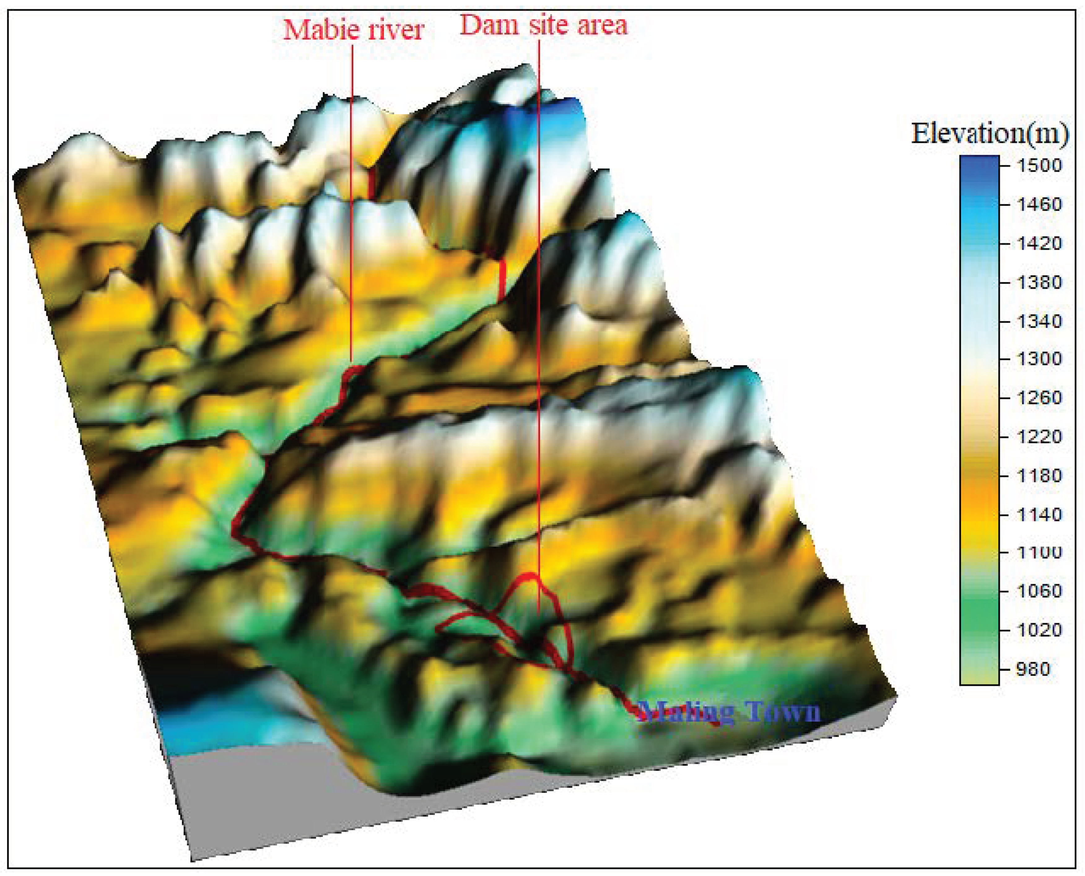
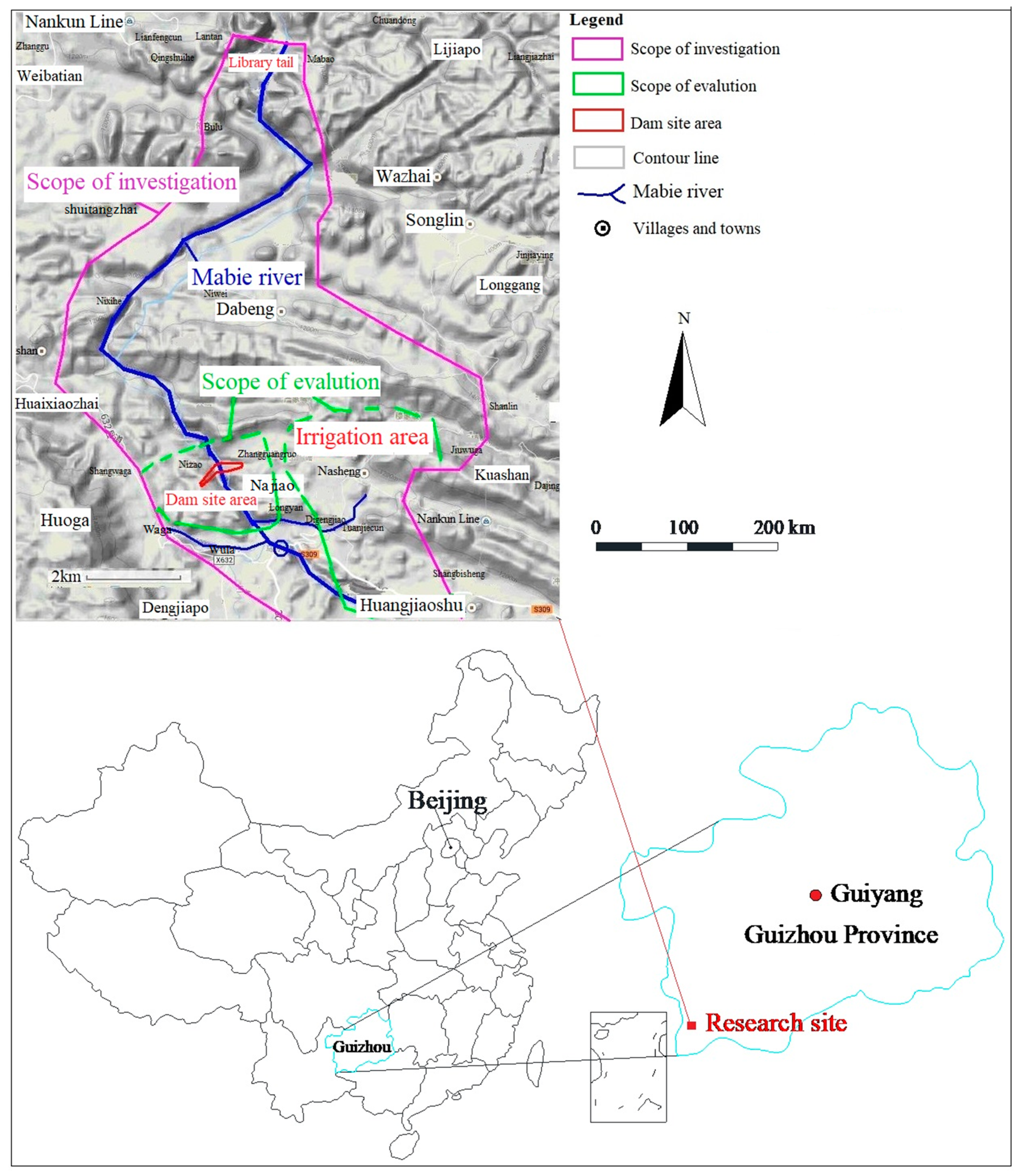
4.2. Analysis of Reservoir Immersion
According to the geological survey of the reservoir area, there was no large-scale immersion (i.e., inundation) problem along the banks of the reservoir area. However, there was a possibility of small-scale immersion in the area around the Nizao village on the right bank of the reservoir. The area was a shale depression of mud shale and dolomite that originates from T2g2 and T2g1-2, with an area of about 0.15 km2. The farmland was widely distributed on the ground, with a minimum elevation of 1030.6 m. On the east side, there was spring water at the interface between T2g2 and T2g1-2 with an elevation of 1042 m. After the reservoir water returned to the mud gully, it was only 200 m away from the lowest point of the depression. The terrain between the two places was gentle and low (the highest point was only 1041.15 m). The lithology was weak and broken, which could not effectively block the penetration of the reservoir water into the depression. Therefore, with the elevation of the water level in the reservoir, the groundwater level in the Nizao village increased correspondingly and resulted in the immersion of farmland in the depression. Meanwhile, the poor drainage of the depression was also likely to cause short-term water logging.
4.4. Leakage Analysis in the Reservoir Area
(1) Analysis of leakage in adjacent valley
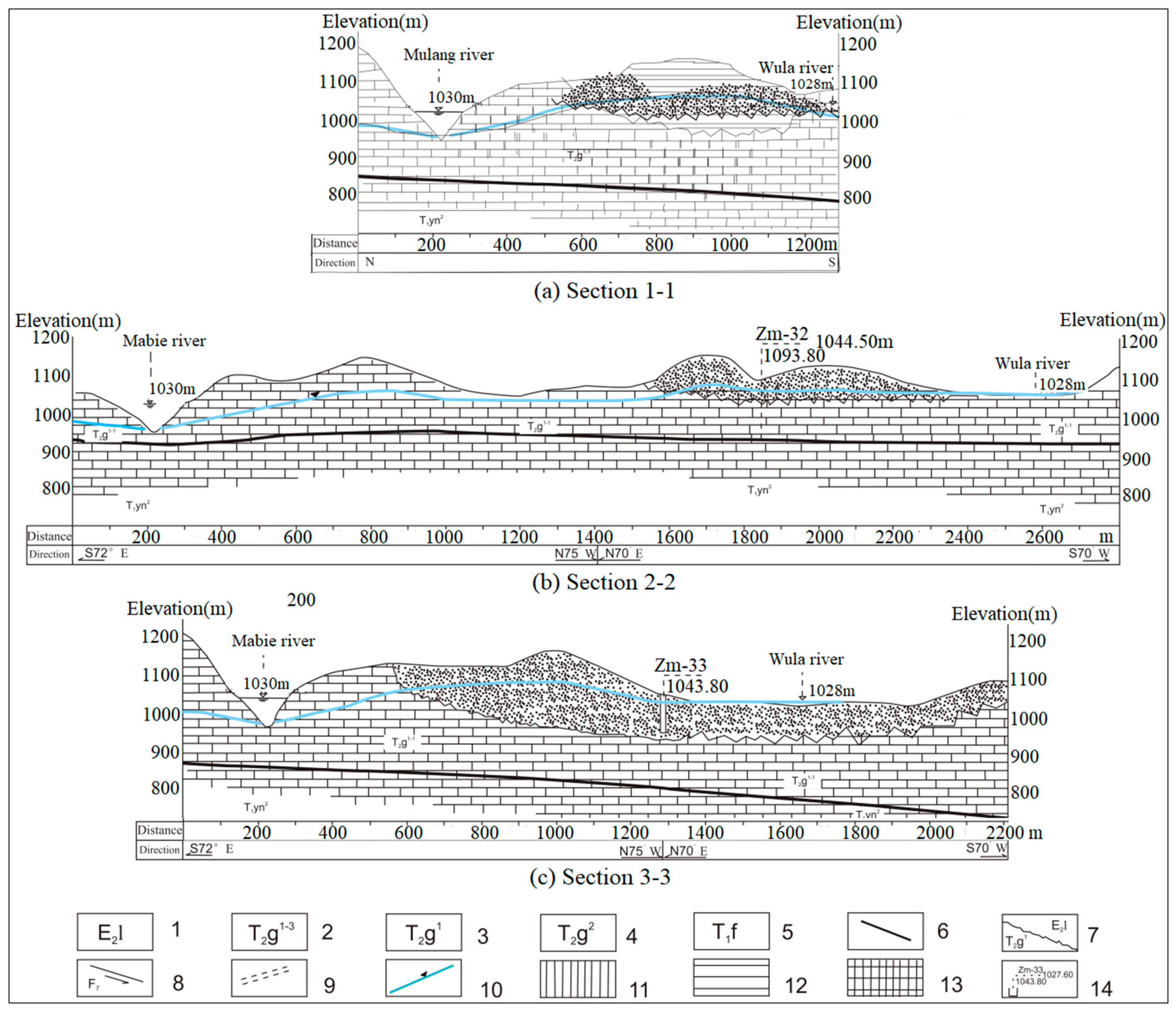
The rock stratum of the dam site intersected with the river at a large angle (50°–60°) and steeply descended downstream. The degree of karst development was controlled by lithology. The karst permeability distribution extended continuously to both sides, while the water permeability along the upper and lower reaches of the river was characterized by interphase distribution. The karst developed weakly because of the distribution of soluble and non-soluble rocks. The mountains on both sides of the reservoir were majestic with high surface and underground watersheds. There were no low neighboring valleys. Although the karst was more developed in the reservoir area, no large pipelines occurred in the reservoir. Therefore, there was no possibility of karst leakage from the large-scale adjacent valley.
(2) Analysis of leakage between river blocks on the right bank of the reservoir area
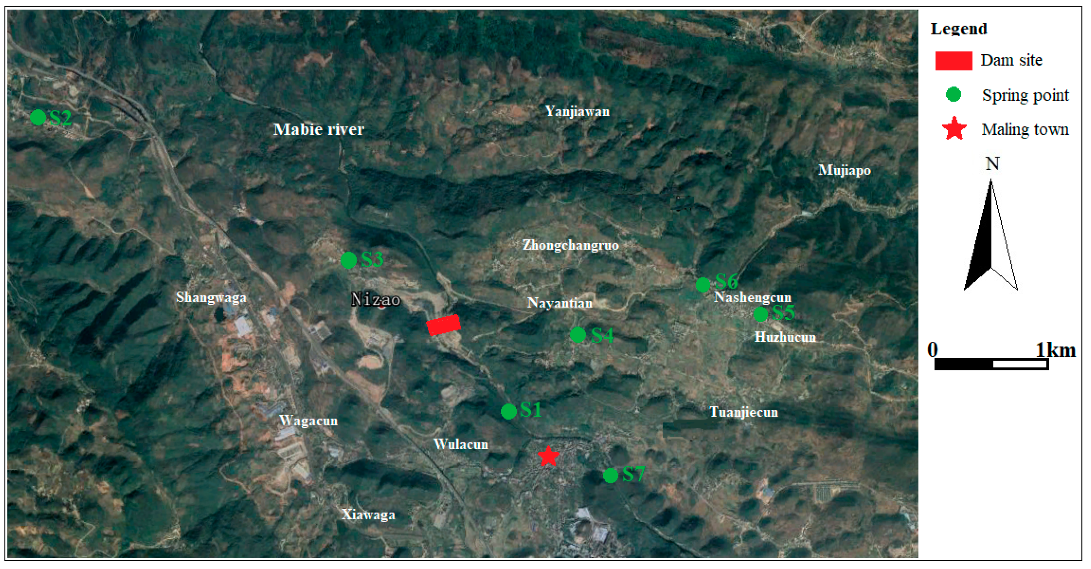
At 1.6 to 3.5 km upstream of the dam site, the Mulang River and the Mabie River meet on the right bank of the reservoir. An interstream block was formed between the Mabie River–Mulang River and the Wula river because the reservoir backwatered to the upper part of Mulang river. The narrowest part of the inter-river block was about l km when the normal water level was 1030 m. The stratum is T
1yn limestone, T
2g dolomite, gray dolomite mud shale, and T
1f red sand shale. The red conglomerate strata of E
2l are widely distributed roughly east–west. The faults F
2 and F
3 are also developed along the east–west direction and a small number of unidentified faults cross the stratum in the north–south direction. However, due to the distribution of red sand shale between the Mulang River and the Wula River with a thickness of 625 m, which blocks the hydraulic connection between the Mulang River and the Wula River, the possibility of leakage is very small (
Figure 5a).
The Wula River on the right bank of the reservoir originates from the vicinity of Shangwa and is formed by the Daoban Creek and some nearby springs and gullies. It extends east–west in the upper section of Shangwaga. It flows to the south and east in the lower section of Shangwaga. It constitutes a low neighboring valley because its river level is slightly lower than the normal water level of the MWCP (1030 m). The E
2l layer of the inter-river block has good water-blocking performance with small depression in a local area. In addition, the percolation diameter is long (1.2–2 km). The water head inside and outside the reservoir is only 5–10 m and an underground watershed is above the normal water level. Therefore, there is no possibility of leakage along the two layers of T
2g
1-1 and T
1yn
1. The remaining formations such as T
1yn
2 and T
2g
1-2 are water-repellent layers and will not leak (
Figure 5b,c).
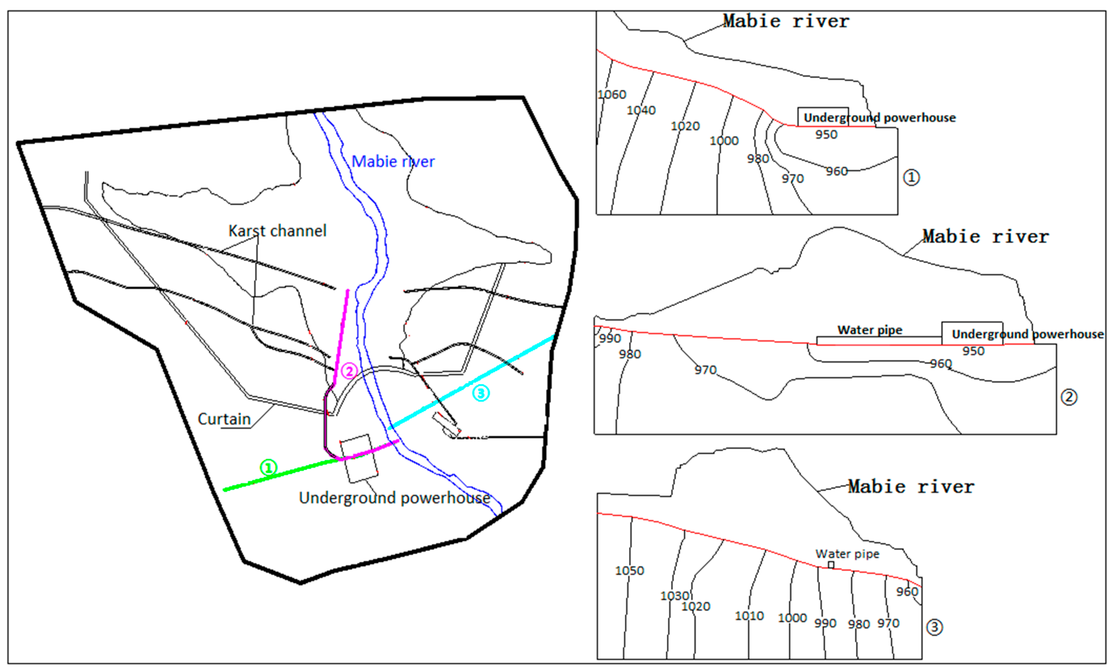
4.6. Analysis of Groundwater Level
Before the excavation of the water conveyance tunnel and underground powerhouse, the inclined and lower flat sections and the workshop were below the groundwater level (about 990 m) except for the upper flat section of the water conveyance system. The contour map of the groundwater level in different sections during the construction period is shown in
Figure 6. The groundwater level plummeted after the excavation of the cavern. The groundwater level descended along the inclined well and it was adjacent to the outer wall of the high-pressure branch pipe, indicating that the unlined diversion well and the high-pressure branch pipe had strong water guiding effect. The decline of the free surface was mainly due to the fact that most of the permeate water flows into the diversion pipe. Finally, a plant-centered landing funnel was formed. Since the floor of the plant was basically the same as the water level of the Mabie River, the groundwater entering the plant through the river was less.
The bottom surface of the plant and the surrounding wall were surrounded by free surfaces, which indicates that groundwater near the plant escapes through the unlined plant floor and the surrounding side walls. The top of the plant was in an unsaturated zone, so no groundwater penetrates into the plant through the top of the plant. The inclined section, the lower section, and the irrigation section of the diversion power generation system were located below the groundwater level line. The construction excavation would cause the groundwater level to drop to a certain extent. The corresponding groundwater anti-seepage measures were taken during the construction of the project. The various measures began to function after the completion of the construction. The surrounding groundwater could quickly return to the natural condition under the effect of the surrounding groundwater, surface water, and rainfall.
After the reservoir was filled with water, the groundwater was mainly discharged from the upper reservoir to the downstream of the dam and the factory building. The water level around the inundation area was relatively high and gradually decreased radially to the surrounding area. The groundwater level in the reservoir tailwater was relatively low. The groundwater level decreased slowly and had little difference with the natural state. The groundwater level of the plant had dropped by about 2–5 m owing to the drainage. The water level of the water pipeline had increased by 10–20 m. The water level of the mountain on both sides had increased by about 15–25 m. The construction had changed the local seepage field distribution around the underground powerhouse, but the scope of influence was mainly limited to a small area near the plant. Generally speaking, it had little effect on the groundwater level and flow field in the study area after the project operation. However, it had some influence on the groundwater flow field of local areas due to the effect of engineering anti-seepage and precipitation measures, such as the plant.
4.7. Analysis of Groundwater Quality
The main sources of water pollution during construction were gravel processing system wastewater, concrete mixing system wastewater, mechanical repair plant oily wastewater, and foundation pit wastewater. The main contaminants in sewage wastewater were BOD5, COD, SS, and petroleum. Their concentrations were, respectively, 200 mg/L, 400 mg/L, 5000 mg/L, and 40 mg/L.
(1) Analysis of the impact on shallow groundwater
The engineering exploration data show that the single layer thickness of the first rock layer is Mb > 1.0 m. The permeability of the shallow rock mass is mainly 5–10 Lu (1 Lu is about 10−5 cm/s). The vertical permeability coefficient is between 10−6cm/s and 10−4cm/s. The anti-fouling performance of the vadose zone is medium, indicating that shallow groundwater is not susceptible to pollution. If the wastewater is leaking, the contaminants will pass through the aeration zone slowly, which has less impact on the quality of the shallow groundwater.
(2) Analysis of the impact on deep groundwater
Deep groundwater in the project area includes fissure water and karst water according to the analysis of geological conditions. Taking atmospheric precipitation as the main source of recharge, surface water and ditch water are also sources of replenishment of low-altitude karst water and they are excreted in the form of spring water. In summary, there is a certain relationship between regional groundwater aquifers. However, it has little impact on the quality of deep groundwater.
(3) Analysis of the influence of groundwater around the cavern
The project adopted the method of draining or collecting wells and collecting water from the pump and drained the water from the tunnels. Finally, it entered the sedimentation tank set up at the cave and was used for watering, forest irrigation, etc. Therefore, it had little impact on the surrounding groundwater.
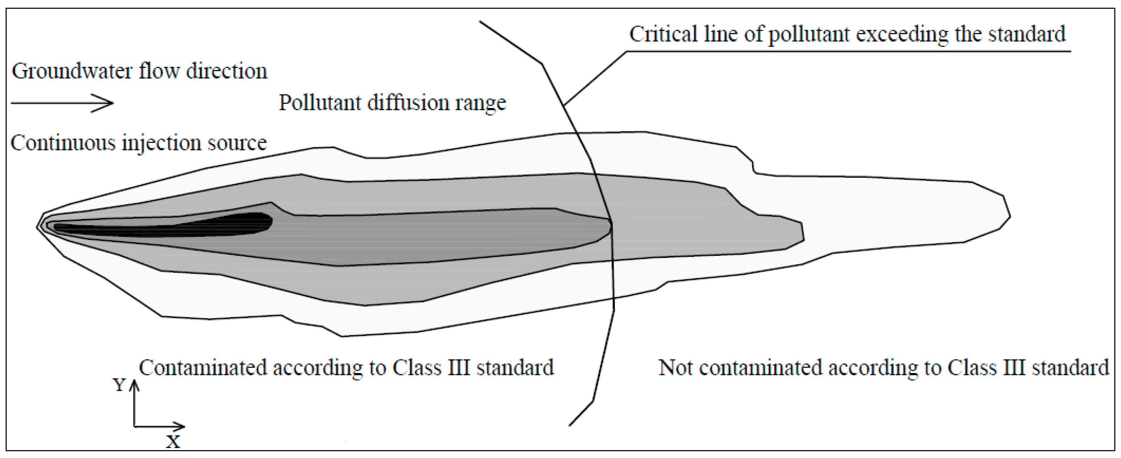
The wastewater will leak when the anti-seepage of the wastewater treatment facility is not in place or fails. The leakage during the construction period is about 211.8 m
3/d when the leakage of the sewage is calculated according to 5% of the generated amount. At this time, we could formulate according to Equation (7) to predict the migration of contaminants. The calculation parameters are shown in
Table 6. For the contaminants in abnormal conditions, the excess diffusion distance of contaminants after 100 days, 1 year, 3 years, 5 years, and 10 years after the continuous discharge of the wastewater was calculated (
Table 7). Under abnormal conditions, the migration distance of contaminants exceeds the standard as the time increases. It shows that if the groundwater is polluted in the karst area, the migration distance of the contaminants is large and the contaminants are easy to spread.
The source of sewage in the operation period of the reservoir was mainly domestic sewage, which was estimated to be 30 m3/d. If the anti-seepage measures are in place, the amount of sewage infiltration can be neglected and the operation period of the reservoir has little impact on groundwater quality.


