A Rapid Assessment Method to Identify Potential Groundwater Flooding Hotspots as Sea Levels Rise in Coastal Cities
Abstract
:1. Introduction
Bay Area Sea Level Rise and Groundwater
2. Materials and Methods
2.1. Study Area
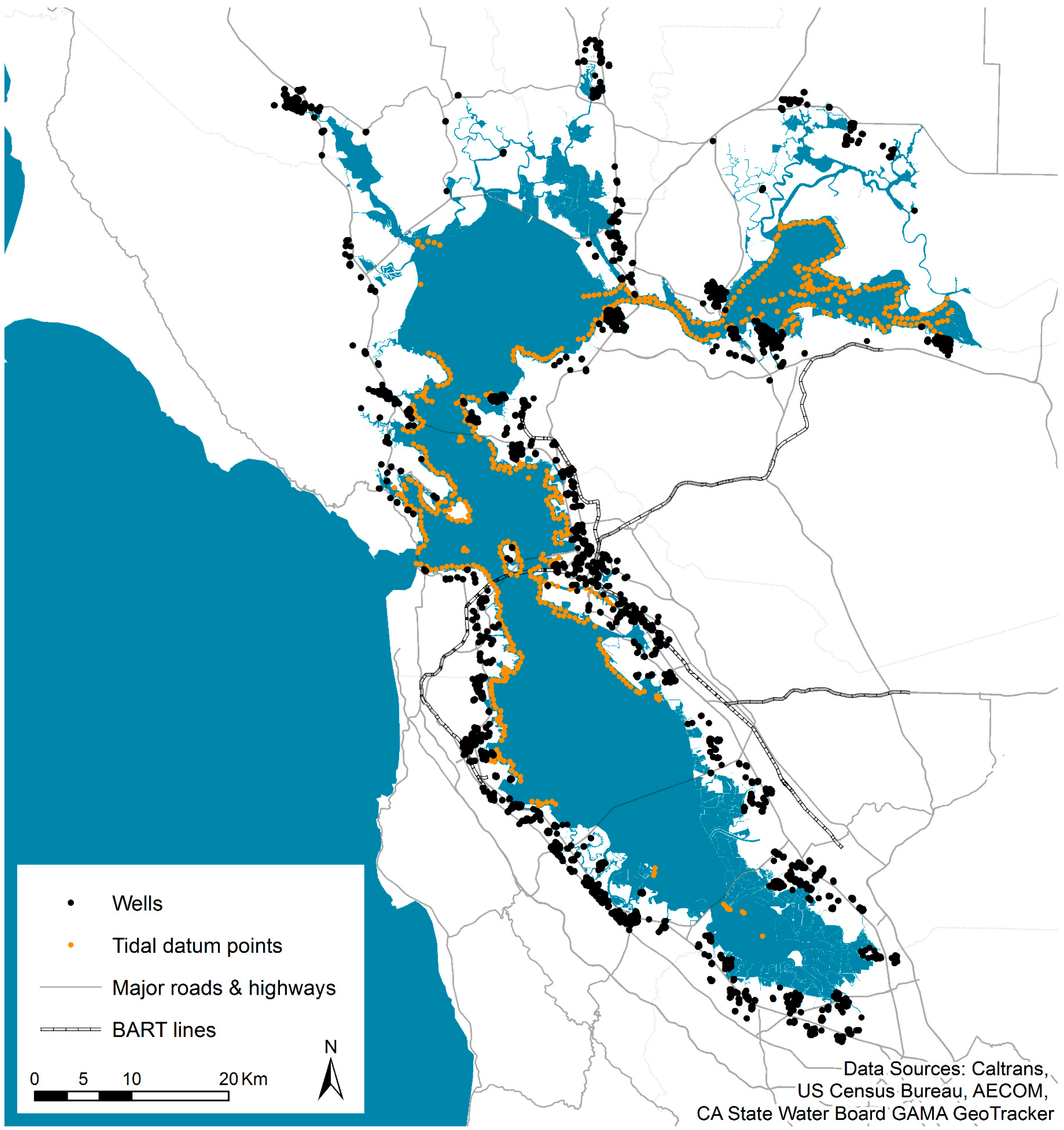
2.2. Monitoring Well Data
2.3. Quality Control for Monitoring Well Data
2.4. Tidal Data
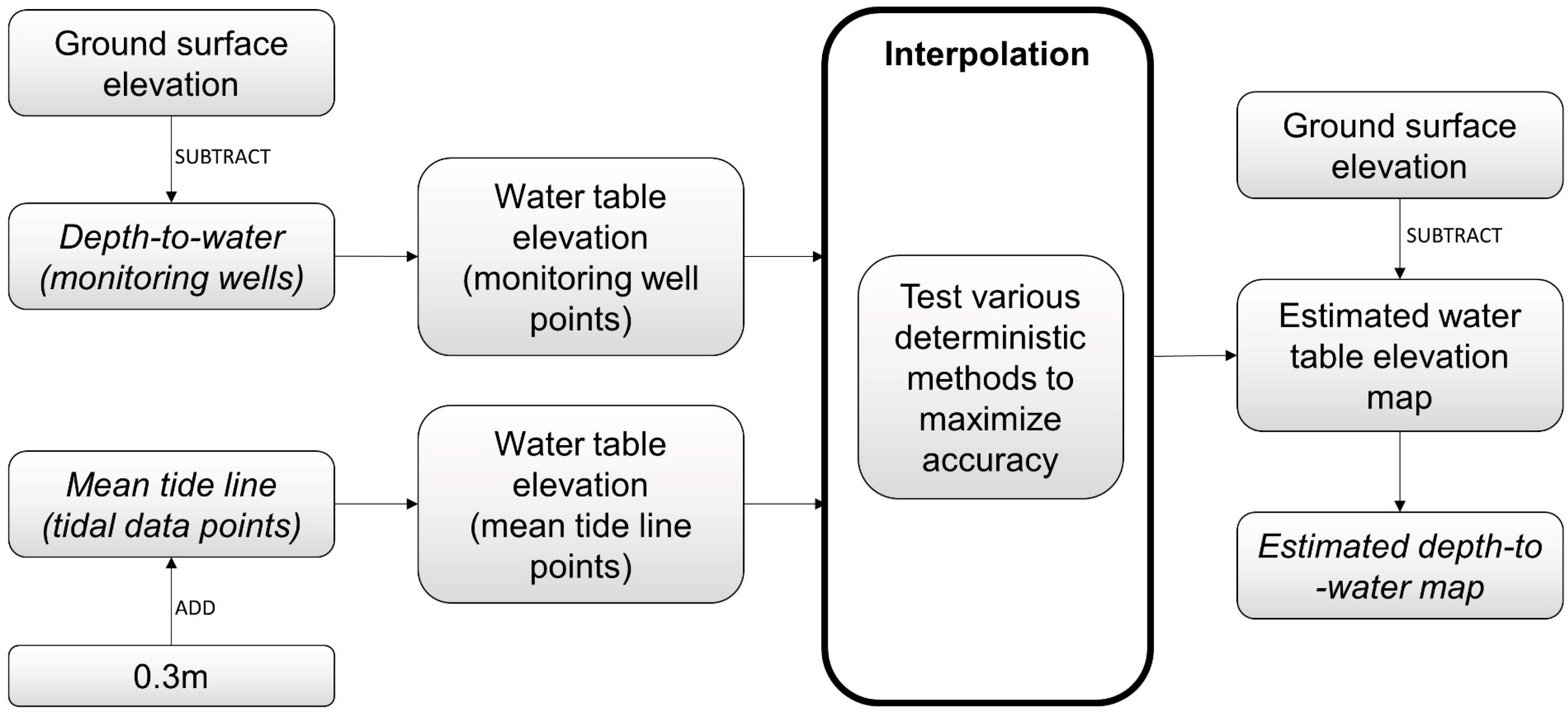
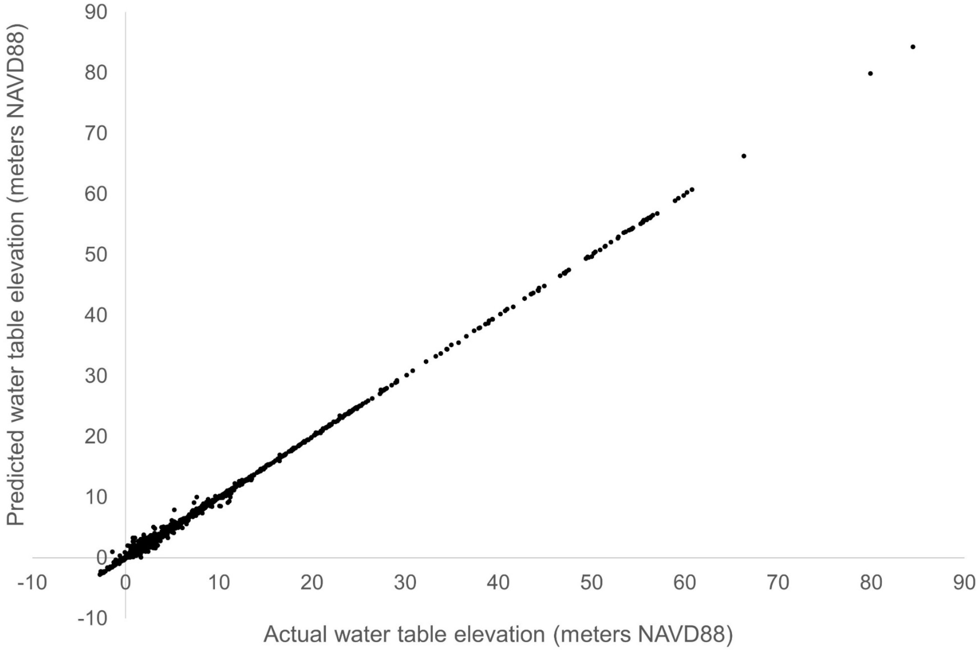
2.5. Analysis
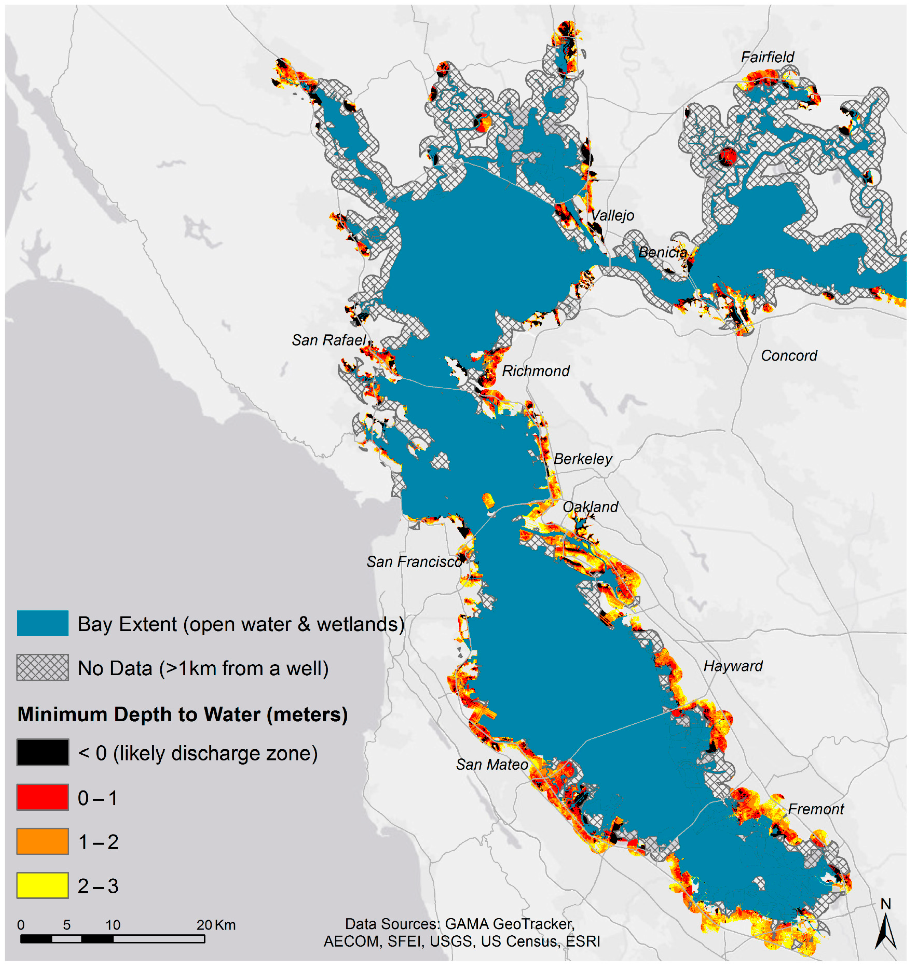
3. Results
Projecting Future Conditions
4. Discussion
5. Conclusions
Author Contributions
Funding
Acknowledgments
Conflicts of Interest
References
- Intergovernmental Panel on Climate Change. Climate Change 2013: The Physical Science Basis. Contribution of Working Group I to the Fifth Assessment Report of the Intergovernmental Panel on Climate Change; Cambridge University Press: Cambridge, UK; New York, NY, USA, 2013. [Google Scholar]
- Bjerklie, D.M.; Mullaney, J.R.; Stone, J.R.; Skinner, B.J.; Ramlow, M.A. Preliminary Investigation of the Effects of Sea-Level Rise on Groundwater Levels in New Haven, Connecticut; U.S. Geological Survey: Reston, VA, USA, 2012; p. 46.
- Cooper, H.H. Sea Water in Coastal Aquifers; US Government Printing Office: Washington, DC, USA, 1964.
- Hoover, D.J.; Odigie, K.O.; Swarzenski, P.W.; Barnard, P. Sea-level rise and coastal groundwater inundation and shoaling at select sites in California, USA. J. Hydrol. Reg. Stud. 2017, 11, 234–249. [Google Scholar] [CrossRef] [Green Version]
- Rotzoll, K.; Fletcher, C.H. Assessment of groundwater inundation as a consequence of sea-level rise. Nat. Clim. Chang. 2012, 3, 477–481. [Google Scholar] [CrossRef]
- Chesnaux, R. Closed-form analytical solutions for assessing the consequences of sea-level rise on groundwater resources in sloping coastal aquifers. Hydrogeol. J. 2015, 23, 1399–1413. [Google Scholar] [CrossRef]
- Werner, A.D.; Simmons, C.T. Impact of Sea-Level Rise on Sea Water Intrusion in Coastal Aquifers. Ground Water 2009, 47, 197–204. [Google Scholar] [CrossRef] [PubMed]
- Chang, S.W.; Clement, T.P.; Simpson, M.J.; Lee, K.-K. Does sea-level rise have an impact on saltwater intrusion? Adv. Water Resour. 2011, 34, 1283–1291. [Google Scholar] [CrossRef] [Green Version]
- Michael, H.A.; Russoniello, C.J.; Byron, L.A. Global assessment of vulnerability to sea-level rise in topography-limited and recharge-limited coastal groundwater systems. Water Resour. Res. 2013, 49, 2228–2240. [Google Scholar] [CrossRef]
- Nuttle, W.K.; Portnoy, J.W. Effect of rising sea level on runoff and groundwater discharge to coastal ecosystems. Estuar. Coast. Shelf Sci. 1992, 34, 203–212. [Google Scholar] [CrossRef]
- Galloway, D.L.; Burbey, T.J. Review: Regional land subsidence accompanying groundwater extraction. Hydrogeol. J. 2011, 19, 1459–1486. [Google Scholar] [CrossRef]
- Scott, J.M.; Schipper, J. Gap analysis: A spatial tool for conservation planning. In Principles of Conservation Biology, 3rd ed.; Groom, M.J., Meffe, G.K., Carroll, C.R., Eds.; Sinauer: Sunderland, MA, USA, 2006; pp. 518–519. [Google Scholar]
- Jamei, Y.; Rajagopalan, P.; Sun, Q. (Chayn) Spatial structure of surface urban heat island and its relationship with vegetation and built-up areas in Melbourne, Australia. Sci. Total Environ. 2019, 659, 1335–1351. [Google Scholar] [CrossRef]
- Rembold, F.; Meroni, M.; Urbano, F.; Csak, G.; Kerdiles, H.; Perez-Hoyos, A.; Lemoine, G.; Leo, O.; Negre, T. ASAP: A new global early warning system to detect anomaly hot spots of agricultural production for food security analysis. Agric. Syst. 2019, 168, 247–257. [Google Scholar] [CrossRef]
- Hummel, M.A.; Berry, M.S.; Stacey, M.T. Sea Level Rise Impacts on Wastewater Treatment Systems Along the U.S. Coasts. Earth’s Future 2018, 6, 622–633. [Google Scholar] [CrossRef] [Green Version]
- Smith, R.A. Center for Operational Oceanographic Products and Services. In Historical Golden Gate Tidal Series; NOAA: Silver Spring, MD, USA, 2002. [Google Scholar]
- Knowles, N. Potential Inundation Due to Rising Sea Levels in the San Francisco Bay Region. San Franc. Estuary Watershed Sci. 2010, 8. [Google Scholar] [CrossRef] [Green Version]
- Vandever, J.; Lightner, M.; Kassem, S.; Guyenet, J.; Mak, M.; Bonham-Carter, C. Adapting to Rising Tides: Bay Area Sea Level Rise Analysis and Mapping Project; San Francisco Bay Conservation and Development Commission, Metropolitan Transportation Commission, Bay Area Toll Authority, AECOM, San Francisco, CA: 2017. Available online: http://www.adaptingtorisingtides.org/wp-content/uploads/2018/07/BATA-ART-SLR-Analysis-and-Mapping-Report-Final-20170908.pdf (accessed on 22 April 2018).
- Takekawa, J.Y.; Thorne, K.M.; Buffington, K.J.; Spragens, K.A.; Swanson, K.M.; Drexler, J.Z.; Schoellhamer, D.H.; Overton, C.T.; Casazza, M.L. Final Report for Sea-Level Rise Response Modeling for San Francisco Bay Estuary Tidal Marshes; Open-File Report; U.S. Geological Survey: Reston, VA, USA, 2013; p. 171.
- USGS. Point Blue Conservation Science OCOF Our Coast, Our Future Flood Map. Available online: http://data.pointblue.org/apps/ocof/cms/index.php?page=flood-map (accessed on 19 June 2019).
- Shirzaei, M.; Bürgmann, R. Global climate change and local land subsidence exacerbate inundation risk to the San Francisco Bay Area. Sci. Adv. 2018, 4, eaap9234. [Google Scholar] [CrossRef] [PubMed] [Green Version]
- Masterson, J.P.; Garabedian, S.P. Effects of Sea-Level Rise on Ground Water Flow in a Coastal Aquifer System. Ground Water 2007, 45, 209–217. [Google Scholar] [CrossRef]
- Planert, M.; Williams, J.S. Groundwater Atlas of the United States: California, Nevada (HA 730-B, Coastal Basins Aquifers); USGS: 1995. Available online: https://pubs.usgs.gov/ha/ha730/ch_b/B-text4.html (accessed on 14 July 2017).
- Ferriz, H. Groundwater resources of northern California: An overview. Eng. Geol. Pract. North. Calif. Bull. 2001, 210, 19–47. [Google Scholar]
- CA State Water Resources Control Board GeoTracker. Available online: http://geotracker.waterboards.ca.gov/data_download_by_county (accessed on 29 January 2017).
- San Francisco Estuary Institute Bay Area Aquatic Resource Inventory (BAARI) Version 2.1 GIS Data. Available online: http://www.sfei.org/data/baari-version-21-gis-data (accessed on 14 October 2016).
- Mak, M.; Harris, E.; Lightner, M.; Vandever, J.; May, K. San Francisco Bay Tidal Datums and Extreme Tides Study; Prepared for the Federal Emergency Management Agency by AECOM: Oakland, CA, USA, 2016; Available online: https://www.adaptingtorisingtides.org/wp-content/uploads/2016/05/20160429.SFBay_Tidal-Datums_and_Extreme_Tides_Study.FINAL_.pdf (accessed on 25 October 2016).
- Moss, A. Coastal Water Table Mapping: Incorporating Groundwater Data into Flood Inundation Forecasts. Master’s Thesis, Duke University, Durham, NC, USA, 2016. [Google Scholar]
- Akkala, A.; Devabhaktuni, V.; Kumar, A. Interpolation techniques and associated software for environmental data. Environ. Prog. Sustain. Energy 2010, 29, 134–141. [Google Scholar] [CrossRef]
- Buchanan, S.; Triantafilis, J. Mapping Water Table Depth Using Geophysical and Environmental Variables. Ground Water 2009, 47, 80–96. [Google Scholar] [CrossRef]
- Cooper, H.M.; Zhang, C.; Selch, D. Incorporating uncertainty of groundwater modeling in sea-level rise assessment: A case study in South Florida. Clim. Chang. 2015, 129, 281–294. [Google Scholar] [CrossRef]
- Sun, Y.; Kang, S.; Li, F.; Zhang, L. Comparison of interpolation methods for depth to groundwater and its temporal and spatial variations in the Minqin oasis of northwest China. Environ. Model. Softw. 2009, 24, 1163–1170. [Google Scholar] [CrossRef]
- Griggs, G.; Arvai, J.; Cayan, D.; DeConto, R.; Fox, J.; Fricker, H.; Kopp, R.; Tebaldi, C.; Whiteman, E.; California Ocean Protection Council Science Advisory Team Working Group. Rising Seas in California: An Update on Sea-Level Rise Science; California Ocean Science Trust: 2017. Available online: http://www.oceansciencetrust.org/wp-content/uploads/2017/04/OST-Sea-Level-Rising-Report-Final_Amended.pdf (accessed on 9 May 2017).
- All Bay Collective, Resilient by Design Bay Area Challenge. The Estuary Commons: People, Place, and a Path Forward 2018. Available online: http://www.resilientbayarea.org/estuary-commons (accessed on 20 August 2019).
- SFEI and SPUR. San Francisco Bay Shoreline Adaptation Atlas: Working with Nature to Plan for Sea Level Rise Using Operational Landscape Units; San Francisco Estuary Institute: Richmond, CA, USA, 2019. [Google Scholar]
- Habel, S.; Fletcher, C.H.; Rotzoll, K.; El-Kadi, A.I. Development of a model to simulate groundwater inundation induced by sea-level rise and high tides in Honolulu, Hawaii. Water Res. 2017, 114, 122–134. [Google Scholar] [CrossRef]
- Luoma, S.; Okkonen, J. Impacts of Future Climate Change and Baltic Sea Level Rise on Groundwater Recharge, Groundwater Levels, and Surface Leakage in the Hanko Aquifer in Southern Finland. Water 2014, 6, 3671–3700. [Google Scholar] [CrossRef] [Green Version]
| Statistic | Value |
|---|---|
| Count | 10,777 |
| Minimum | 0 m |
| Maximum | 6.46 m |
| Mean | 1.95 m |
| Median | 1.75 m |
| Standard Deviation | 1.21 m |
| Maximum Groundwater Elevation | ||
|---|---|---|
| RMSE | ME | |
| Inverse Distance Weighting (IDW) | 1.237 | −0.021 |
| Global Polynomial Interpolation (GPI) | 5.114 | −0.001 |
| Radial Basis Functions (RBF): Multiquadric | 1.167 | −0.010 |
| RBF: Completely Regularized Spline | 1.579 | −0.006 |
| RBF: Spline with Tension | 1.482 | −0.006 |
| RBF: Inverse Multiquadric | 2.638 | −0.003 |
| Extent of Potential Flooding with 1 m SLR, km2 (% of Total) | ||||
|---|---|---|---|---|
| County | Direct SLR only 1 | Emergent Groundwater only | Both Direct SLR 1 and Emergent Groundwater | Total |
| Alameda | 3.3 (8%) | 28.3 (72%) | 7.7 (20%) | 39.3 |
| Contra Costa | 0.7 (3%) | 19.5 (87%) | 2.2 (10%) | 22.5 |
| Marin | - | 9.1 (65%) | 4.8 (35%) | 13.9 |
| Napa | - | 8.2 (98%) | 0.2 (2%) | 8.4 |
| San Francisco | - | 4.3 (88%) | 0.6 (12%) | 4.8 |
| San Mateo | 11.7 (30%) | 8.3 (21%) | 19.0 (49%) | 39.1 |
| Santa Clara | 7.3 (56%) | 2.3 (18%) | 3.5 (27%) | 13.1 |
| Solano | 1.3 (6%) | 15.6 (68%) | 6.1 (26%) | 23.0 |
| Sonoma | 1.2 (9%) | 9.3 (73%) | 2.2 (17%) | 12.7 |
| Total | 25.6 (14%) | 104.9 (59%) | 46.2 (26%) | 176.8 |
© 2019 by the authors. Licensee MDPI, Basel, Switzerland. This article is an open access article distributed under the terms and conditions of the Creative Commons Attribution (CC BY) license (http://creativecommons.org/licenses/by/4.0/).
Share and Cite
Plane, E.; Hill, K.; May, C. A Rapid Assessment Method to Identify Potential Groundwater Flooding Hotspots as Sea Levels Rise in Coastal Cities. Water 2019, 11, 2228. https://doi.org/10.3390/w11112228
Plane E, Hill K, May C. A Rapid Assessment Method to Identify Potential Groundwater Flooding Hotspots as Sea Levels Rise in Coastal Cities. Water. 2019; 11(11):2228. https://doi.org/10.3390/w11112228
Chicago/Turabian StylePlane, Ellen, Kristina Hill, and Christine May. 2019. "A Rapid Assessment Method to Identify Potential Groundwater Flooding Hotspots as Sea Levels Rise in Coastal Cities" Water 11, no. 11: 2228. https://doi.org/10.3390/w11112228
APA StylePlane, E., Hill, K., & May, C. (2019). A Rapid Assessment Method to Identify Potential Groundwater Flooding Hotspots as Sea Levels Rise in Coastal Cities. Water, 11(11), 2228. https://doi.org/10.3390/w11112228


